St Austell to A30 Link - Cornwall Council
←
→
Page content transcription
If your browser does not render page correctly, please read the page content below

St Austell to A30 Link
Traffic Forecasting Report

Project reference: 0128
Project number: 60571547

March 2020

St Austell to A30 Link
 Project reference: 0128
 Project number: 60571547

Quality information
Prepared by Checked by Verified by Approved by

Alex Bertram Tom Holian Maurice Houkes Thea Wattam
Consultant Senior Consultant Associate Director Associate Director

Revision History
Revision Revision date Details Authorized Name Position
V0.1 16/09/19 Draft Issue 16/09/2019 Thea Wattam Associate
 Director
V0.2 12/03/20 DfT comments 31/03/2020 Maurice Houkes Associate
 Director
V0.3 19/08/20 Table 3-3 19/08/2020 Maurice Houkes Associate
 correction Director

Prepared for: CORMAC Solutions Ltd AECOM
St Austell to A30 Link
 Project reference: 0128
 Project number: 60571547

Prepared for:
CORMAC Solutions Ltd

Prepared by:

AECOM Limited
3rd Floor, Portwall Place
Portwall Lane
Bristol BS1 6NA
United Kingdom

T: +44 117 901 7000
aecom.com

© 2020 AECOM Limited. All Rights Reserved.

This document has been prepared by AECOM Limited (“AECOM”) for sole use of our client (the
“Client”) in accordance with generally accepted consultancy principles, the budget for fees and the
terms of reference agreed between AECOM and the Client. Any information provided by third parties
and referred to herein has not been checked or verified by AECOM, unless otherwise expressly stated
in the document. No third party may rely upon this document without the prior and express written
agreement of AECOM.

Prepared for: CORMAC Solutions Ltd AECOM
St Austell to A30 Link
 Project reference: 0128
 Project number: 60571547

Table of Contents
1. Executive Summary ................................................................................ 7
2. Study Overview ....................................................................................... 8
2.1 Background........................................................................................................................... 8
2.2 Scheme Objectives ............................................................................................................... 8
2.3 Model Purpose and Assessment Option ................................................................................ 9
2.4 Report Structure.................................................................................................................... 9
3. Overview of Base Year Model ............................................................... 10
3.1 Introduction ......................................................................................................................... 10
3.2 Model Time Periods and Network Structure ......................................................................... 10
3.3 2016 Base Year Trip Matrices.............................................................................................. 16
4. Uncertainty Log and Forecast Years ..................................................... 18
4.1 Demand Forecasting for Specific Developments.................................................................. 18
5. Forecasting Future Year Demand ......................................................... 22
5.1 Overview of Demand Forecasting Procedure....................................................................... 22
5.2 Forecast Time Periods and Years ........................................................................................ 22
5.3 The National Transport Model and NTEM ............................................................................ 22
5.4 Demand Forecasting for Specific Developments.................................................................. 25
5.5 Forecasting Scenarios......................................................................................................... 29
6. Forecasting Future Year Supply ............................................................ 31
6.1 Infrastructure....................................................................................................................... 31
6.2 Future Network: Do Minimum Scenario ............................................................................... 32
6.3 Future Network: Do Something Scenario ............................................................................. 37
7. Variable Demand Modelling .................................................................. 47
7.1 Introduction ......................................................................................................................... 47
7.2 VDM Test: Methodology ...................................................................................................... 47
7.3 VDM Test: Demand Response ............................................................................................ 49
7.4 VDM Tests: Impact to Scheme Benefits ............................................................................... 51
7.5 Conclusion: The Need for VDM ........................................................................................... 53
8. Assignment Results ............................................................................... 54
8.1 Convergence ...................................................................................................................... 54
8.2 Traffic Flows........................................................................................................................ 54
8.3 Screenline Flows................................................................................................................. 60
8.4 Journey Times .................................................................................................................... 63
9. Summary and Conclusions ................................................................... 66
9.1 Summary ............................................................................................................................ 66
9.2 Conclusions ........................................................................................................................ 66
Appendix A Uncertainty Log ............................................................................ 67
Appendix B Convergence Results................................................................... 68
Appendix C Key Link Results .......................................................................... 69
Appendix D Traffic Flow Diagrams .................................................................. 70
Appendix E Screenline Flows .......................................................................... 71
Appendix F Journey Time Results................................................................... 72

Prepared for: CORMAC Solutions Ltd AECOM
St Austell to A30 Link
 Project reference: 0128
 Project number: 60571547

Figures
Figure 2-1: Proposed Scheme Overview ............................................................................................ 9
Figure 3-1: Area of Detailed Study .................................................................................................... 11
Figure 3-2: Zone Plan (detailed Study Area)..................................................................................... 12
Figure 3-3: Zone Plan (Cornwall) ..................................................................................................... 13
Figure 3-4: Zone Plan (Rest of Modelled Area)................................................................................. 14
Figure 3-5: Cornwall Network........................................................................................................... 16
Figure 3-6: South UK Network ......................................................................................................... 16
Figure 4-1: Uncertainty Log Development Locations ........................................................................ 20
Figure 6-1: Duporth Traffic Signals ................................................................................................... 33
Figure 6-2: A390 Sawles Road Traffic Signals .................................................................................. 34
Figure 6-3: Edgcumbe Triangle ........................................................................................................ 34
Figure 6-4: Pentewan Roundabout .................................................................................................. 35
Figure 6-5: Higher Trewhiddle Development Roundabout ................................................................ 36
Figure 6-6: Holmbush Development Signals .................................................................................... 37
Figure 6-7: Do Something General Arrangement .............................................................................. 38
Figure 6-8: General Arrangements Drawing 01 of 06........................................................................ 39
Figure 6-9: General Arrangements Drawing 02 of 06........................................................................ 40
Figure 6-10: General Arrangements Drawing 03 of 06...................................................................... 40
Figure 6-11: General Arrangements Drawing 04 of 06 ...................................................................... 41
Figure 6-12: General Arrangements Drawing 05 of 06...................................................................... 42
Figure 6-13: General Arrangements Drawing 06 of 06...................................................................... 43
Figure 6-14: General Arrangements, Complementary Measures and TROs...................................... 44
Figure 6-15: Bugle, Complementary Measures and TROs................................................................ 45
Figure 6-16: Roche, Complementary measures and TROs .............................................................. 46
Figure 7-1: Own Cost Elasticity Test Zone Status ............................................................................. 49
Figure 8-1: Key Links Map ............................................................................................................... 55
Figure 8-2: Screenline Locations...................................................................................................... 60
Figure 8-3: Journey Time Routes ..................................................................................................... 63

Tables
Table 3-1: Modelled Time Period Classification ................................................................................ 10
Table 3-2: Model User Classes ........................................................................................................ 17
Table 3-3: 2016 Base Trips Summary .............................................................................................. 17
Table 4-1: WebTAG Uncertainty Classifications................................................................................ 18
Table 4-2: Uncertainty Log ............................................................................................................... 19
Table 4-3: Development to be Included in Growth Scenarios ............................................................ 21
Table 5-1: Forecast Model Time Periods .......................................................................................... 22
Table 5-2: Development Zone Growth .............................................................................................. 24
Table 5-3: NTEM 7.2 Projections...................................................................................................... 24
Table 5-4: NTEM 7.2 Forecast Growth (Households and Jobs) ........................................................ 24
Table 5-5: Development Zones ........................................................................................................ 25
Table 5-6: Core/Low Growth Development Trip Generation .............................................................. 27
Table 5-7: High Growth Development Trip Generation (Difference to Low/Core Highlighted Blue) ..... 27
Table 5-8: Additional HGV Trips ....................................................................................................... 29
Table 5-9: Core Forecast Matrix Summary ....................................................................................... 30
Table 5-10: High Growth Forecast Matrix Summary ......................................................................... 30
Table 5-11: Low Growth Forecast Matrix Summary .......................................................................... 30
Table 6-1: Future Year Infrastructure Changes ................................................................................. 31
Table 7-1: Elasticity Power Functions ............................................................................................... 48
Table 7-2: Do Minimum Trip Matrix Totals: Fixed vs Elastic ............................................................... 50
Table 7-3: Do Minimum and Do Something Trip Matrix Comparison: Fixed vs Elastic ....................... 51
Table 7-4: Total Distance Travelled: Do Minimum. Fixed vs Elastic ................................................... 51
Table 7-5: Total Distance Travelled: Do Something. Fixed vs Elastic................................................. 51
Table 7-6: Scheme Benefits with Fixed and Elastic Demand ............................................................ 53

Prepared for: CORMAC Solutions Ltd AECOM
St Austell to A30 Link
 Project reference: 0128
 Project number: 60571547

Table 8-1: WebTAG Convergence Criteria........................................................................................ 54
Table 8-2: Convergence Statistics (2022 Core, Do Minimum and Do Something) ............................. 54
Table 8-3: Key Study Links List ........................................................................................................ 55
Table 8-4: Key Link Flow Results, Core Scenario, 2022 AM Peak..................................................... 57
Table 8-5: Key Link Flow Results, Core Scenario, 2022 Inter Peak................................................... 58
Table 8-6: Key Link Flow Results, Core Scenario, 2022 PM Peak .................................................... 59
Table 8-7: Screenline Results, Core Scenario, 2022 AM Peak .......................................................... 60
Table 8-8: Screenline Results, Core Scenario, 2022 Inter Peak ........................................................ 62
Table 8-9: Screenline Results, Core Scenario, 2022 PM Peak.......................................................... 62
Table 8-10: Journey Time Comparison, AM Peak ............................................................................. 64
Table 8-11: Journey Time Comparison, Inter Peak ........................................................................... 64
Table 8-12: Journey Time Comparison, PM Peak ............................................................................. 65

Prepared for: CORMAC Solutions Ltd AECOM
St Austell to A30 Link
 Project reference: 0128
 Project number: 60571547

1. Executive Summary
 The existing route between St Austell and the A30 is of a variable standard, passing through
 a number of villages, with congestion and delays leading to poor journey time reliability. The
 new route is needed to help meet Cornwall Council’s objectives of relieving traffic issues
 along the current route and unlocking economic potential within St Austell and the
 surrounding area.

 Cornwall Council and local stakeholders hold an aspiration to create an improved strategic
 link between St Austell and the A30. St Austell is Cornwall’s largest town and is not currently
 served by a high-quality road link to the A30. The proposed scheme is a new high-quality,
 single carriageway route linking St Austell to the A30 and to divert traffic (including Heavy
 Goods Vehicles) away from settlements along the existing route(s).

 Cornwall Council’s overarching aims for the scheme are to:

 • Reduce journey times and improve journey reliability between Newquay, the A30 and St
 Austell;
 • Create a better link between two of Cornwall’s largest towns (St Austell and Newquay),
 the airport and Aerohub Enterprise Zone;
 • Make access to Cornwall’s new, large employment sites easier, therefore supporting
 the expanding employment sites Victoria Business Park, Indian Queens Industrial
 Estate and the Aerohub Enterprise Zone;
 • Improve the competitiveness of St Austell as a location to do business via new
 employment space or interest in land that can be developed into employment space;
 • Support housing growth, including the delivery West Carclaze Garden Village
 ecocommunity, which is expected to create 1,500 new homes and 500 jobs; and
 • Support the regeneration of Roche, Bugle and St Dennis by addressing traffic related
 issues within the villages and creating better opportunities for businesses.
 This Traffic Forecasting Report details the development of the forecast year demand
 matrices and future year traffic models that will be used within the appraisal of the proposed
 scheme.

 The model results forecast that the proposed scheme will provide an improvement to the
 performance of traffic flow between St Austell and the A30. Journey times for vehicles
 travelling between St Austell to the A30 via the proposed scheme are predicted to reduce,
 and traffic flows through the villages of Roche and Bugle are forecast to be significantly
 reduced, with Heavy Goods Vehicles experiencing a reduction of up to 100%.

 Overall, the forecast model results demonstrate traffic patterns that would be reasonably
 expected to occur. As the models have been produced with reference to WebTAG and
 sense checked for validity, it is felt that they provide a suitable basis for assessing the
 impacts of the proposed scheme.

 The 2022 and 2037 future year traffic forecasts produced from the forecasting assessment
 within the main body of this report have been taken forward for use within the economic
 appraisal of the St Austell to A30 Link.

Prepared for: CORMAC Solutions Ltd AECOM
 53
St Austell to A30 Link
 Project reference: 0128
 Project number: 60571547

2. Study Overview
2.1 Background
 Cornwall Council and local stakeholders have an aspiration to create an improved strategic
 link between St Austell and the A30. Although St Austell is Cornwall’s largest town, it is not
 currently served by a high-quality road link to the A30. The current route is the A391, which
 is a variable standard single carriageway route passing through a number of settlements
 between St Austell and the A30.

 Given its status as the largest town in Cornwall, St Austell is a major attractor of trip origins
 and destinations within mid-Cornwall, with heavy industry within the China Clay Area
 attracting a high number of Heavy Goods Vehicle (HGV) trips. The low standard of the
 current route connections to the A30 result in congestion, delays and traffic safety issues
 within affected areas. The route requires improvement to meet Cornwall Council’s objectives
 of improving journey reliability, safety and raising economic competitiveness. The current
 poor connectivity is seen as the major block to the economic growth of the St Austell area.

 The scheme is inherently expected to impact the travel arrangements within St Austell,
 settlements along the current route, and to the wider transport network within Cornwall.
 Travel patterns would be anticipated to be affected because of route performance
 improvements, attracting traffic from other routes. The traffic model has been designed to
 forecast the potential impact of these travel patterns across a wide area.

2.2 Scheme Objectives
 The overarching aim of the scheme is to provide a higher quality link between St Austell and
 the A30, and to divert traffic (including HGVs) away from the towns and villages along the
 existing routes.

 The scheme objectives are aligned with the key policies identified within Cornwall Council’s
 regional transport policies, and the Cornwall and Isles of Scilly Strategic Economic Plan
 (Vision 2030).

 The Council’s objectives for the mid-Cornwall area are:

 • Create a better link between two of Cornwall’s largest towns – St Austell and Newquay,
 the airport and Aerohub Enterprise Zone;
 • Make it easier to access Cornwall’s new, large employment sites and support the
 expanding employment sites Victoria Business Park, Indian Queens Industrial Estate
 and the Aerohub Enterprise Zone;
 • Improve competitiveness of St Austell as a location to do business via new employment
 space or interest in land that can be developed into employment space;
 • Support housing growth, including the delivery West Carclaze Garden Village
 ecocommunity (with the creation 1,500 new homes and 500 jobs); and
 • Support the regeneration of Roche, Bugle and St Dennis by addressing traffic related
 issues within the villages and creating better opportunities for businesses.
 To help achieve these overarching aims, the scheme’s transport-specific objectives are to:

 • Reduce journey times and improve journey reliability between St Austell and A30;
 • Reduce the impact of traffic congestion on local communities and businesses; and
 • Improve the safety of road users, pedestrians and cyclists.

Prepared for: CORMAC Solutions Ltd AECOM
 53
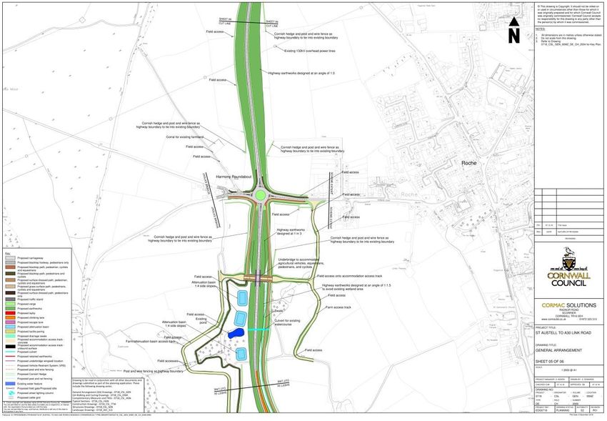
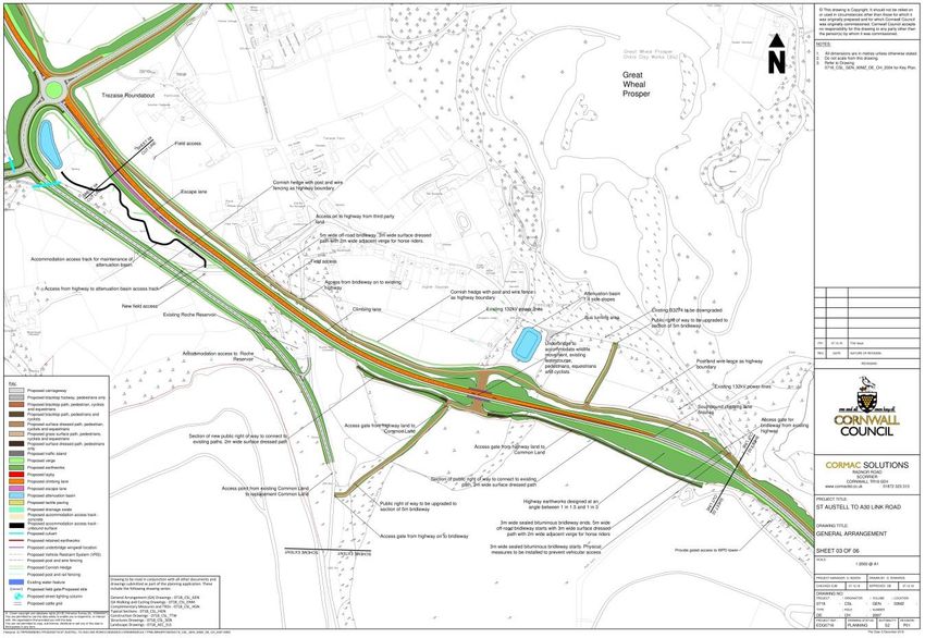
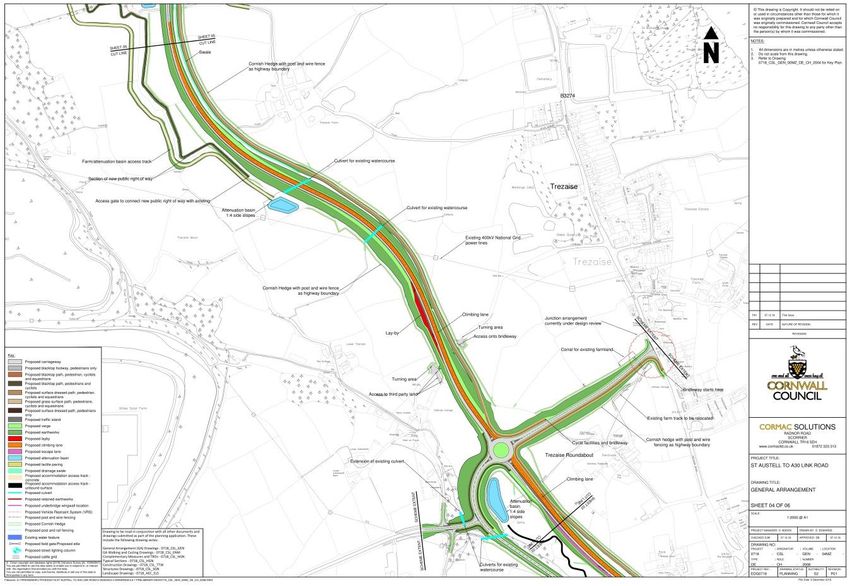
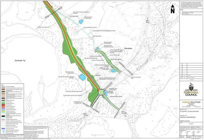
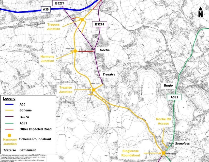
St Austell to A30 Link
 Project reference: 0128
 Project number: 60571547

2.3 Model Purpose and Assessment Option
 The model has been used to appraise the preferred route for the St Austell to A30 Link Road
 scheme. The evaluation process for determining the preferred option is set out in the
 Options Assessment Report (dated March 2017). The forecasting processes documented in
 this report follow the methodology set out in the Appraisal Specification Report (dated
 November 2016) and WSP|PB’s Traffic Forecasting Report (dated March 2017) (TFR),
 produced as part of the Outline Business Case (OBC) evidence base.

 A detailed review of the scheme can be found in Section 6.3, but it broadly follows the
 ‘Roche Option’ assessed in the OBC TFR. The highway has been designed to
 accommodate vehicles travelling at 60mph and will replace the B3274 from Stenalees to
 Trezaise to form a bypass around Roche, linking to the old A30 west of Victoria (Figure 2-1).

Figure 2-1: Proposed Scheme Overview
 In general, the St Austell to A30 Link Road will be single carriageway, with climber lanes
 provided at key locations as required. Four new roundabouts will be constructed at
 Stenalees, Trezaise, Harmony Road and at the old A30 (C0120).

2.4 Report Structure
 This TFR sets out information relating to the development of the forecast scenarios and is
 structured as follows:

 • Chapter 3: Overview of Base Year Model;
 • Chapter 4: Uncertainty Log and Forecast Years;
 • Chapter 5: Forecasting Future Year Demand;
 • Chapter 6: Forecasting Future Year Supply;
 • Chapter 7: Variable Demand Modelling;
 • Chapter 8: Assignment Results; and
 • Chapter 9: Summary and Conclusions.

Prepared for: CORMAC Solutions Ltd AECOM
 53

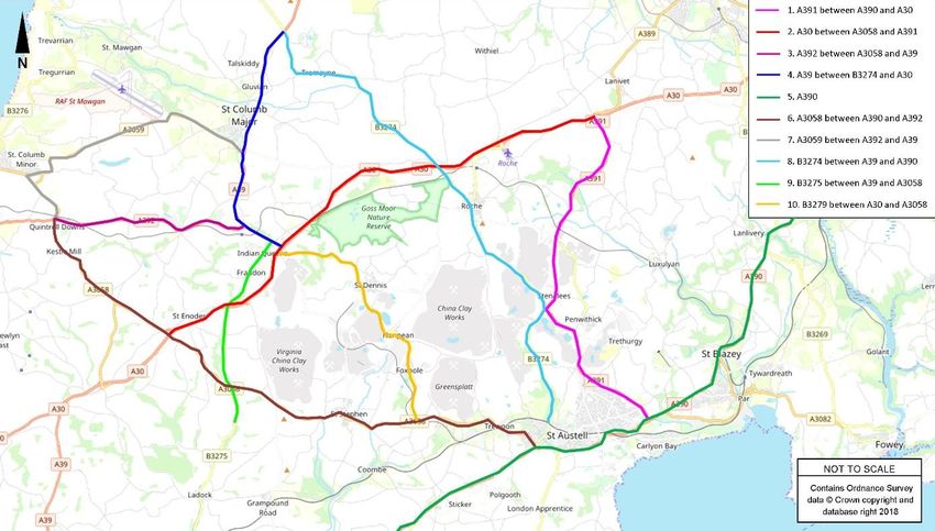
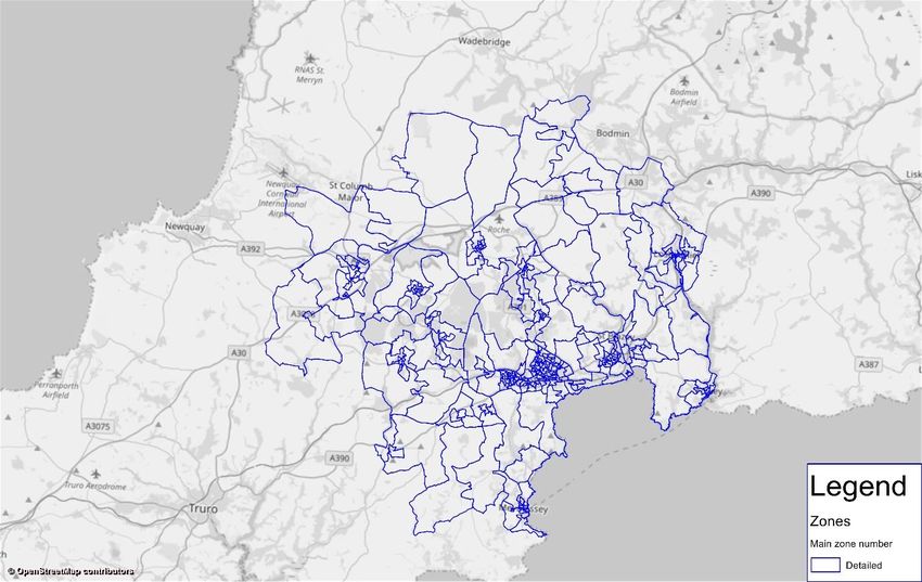
St Austell to A30 Link
 Project reference: 0128
 Project number: 60571547

3. Overview of Base Year Model
3.1 Introduction
 This chapter provides an overview of the Base Year model. The Local Model Validation
 Report (March 2017) details the base model that has been developed by PTV to inform the
 appraisal of the scheme.

 The Base Year model formed the basis for the forecast models detailed in this report.
 Forecast models have been built for 2022 (the proposed opening year of the scheme) and
 2037 (future case fifteen years from the opening year). The forecast models detailed in this
 report have been built in compliance with Department for Transport WebTAG Unit M4
 ‘Forecasting and Uncertainty’ (May 2018).

3.2 Model Time Periods and Network Structure
 Neutral month peak and inter-peak time periods have been modelled to fully understand the
 operation and economic benefits of the proposed scheme. The modelled time periods are
 shown in Table 3-1.

Table 3-1: Modelled Time Period Classification

 Time Period Modelled Period
 Neutral Month AM Peak 08:00 - 09:00
 Neutral Month Inter Peak Ave hour 10:00 – 16:00
 Neutral Month PM Peak 17:00 – 18:00
The main study area covers St Austell and includes the towns of Roche and Bugle to the
north, Lostwithiel and Fowey to the east, Mevagissey to the south, and St Stephens and St
Dennis to the west. The extent of the detailed study area is illustrated Figure 3-1 and

 Figure 3-2.

Prepared for: CORMAC Solutions Ltd AECOM
 53
St Austell to A30 Link
 Project reference: 0128
 Project number: 60571547

Figure 3-1: Area of Detailed Study

Prepared for: CORMAC Solutions Ltd AECOM
 53
St Austell to A30 Link
 Project reference: 0128
 Project number: 60571547

Figure 3-2: Zone Plan (detailed Study Area)
 The remainder of Cornwall has been modelled in varying levels of detail (

Prepared for: CORMAC Solutions Ltd AECOM
 53
St Austell to A30 Link
 Project reference: 0128
 Project number: 60571547

 Figure 3-3). This area is not as detailed as the main study area but allows for the control of
 traffic routes into Cornwall. The wider model area includes the rest of the UK (

 Figure 3-4). Outside of Devon and Cornwall the zones become much larger .

Figure 3-3: Zone Plan (Cornwall)

Prepared for: CORMAC Solutions Ltd AECOM
 53
St Austell to A30 Link
 Project reference: 0128
 Project number: 60571547

Figure 3-4: Zone Plan (Rest of Modelled Area)
 The simulation network (

Prepared for: CORMAC Solutions Ltd AECOM
 53
St Austell to A30 Link
 Project reference: 0128
 Project number: 60571547

 Figure 3-5 and

 Figure 3-6) is formed of the following sections:

 • Cornwall (all roads);
 • Major and intermediate routes in Devon, with slightly more detail in Plymouth and
 Exeter; and
 • Major routes covering the rest of the UK.

Prepared for: CORMAC Solutions Ltd AECOM
 53
St Austell to A30 Link
 Project reference: 0128
 Project number: 60571547

Figure 3-5: Cornwall Network

Figure 3-6: South UK Network

3.3 2016 Base Year Trip Matrices
 The development of base year matrices for 2016 is described in detail in the Local Model
 Validation Report (March 2017) which has been produced by PTV.

 Three user classes (UCs) are used in the Base Year validation process, with each UC
 corresponding to the vehicle type detailed in Table 3-2.

Prepared for: CORMAC Solutions Ltd AECOM
 53
St Austell to A30 Link
 Project reference: 0128
 Project number: 60571547

Table 3-2: Model User Classes

 User Class Purpose
 UC1 Car
 UC4 Light Goods Vehicles (LGV)
 UC5 Heavy Goods Vehicles (HGV)

 Table 3-3 shows the base case matrices total trips.

Table 3-3: 2016 Base Trips Summary

 User Class AM Peak Inter Peak PM Peak
 Car 17,381 15,947 28,307
 LGV 3,188 2,689 2,666
 HGV 1,025 1,041 470
 Total 21,594 19,677 31,443

Prepared for: CORMAC Solutions Ltd AECOM
 53
St Austell to A30 Link
 Project reference: 0128
 Project number: 60571547

4. Uncertainty Log and Forecast
 Years
4.1 Demand Forecasting for Specific Developments
 The following base and forecast years have been adopted:

 • Base Year: 2016;
 • Opening Year: 2022; and
 • Design Year: 2037.
 Cornwall Council-owned Cormac Solutions Limited (Cormac) provided information for
 potential residential and employment development sites within the St Austell area, based
 upon the development plan outlined in the Cornwall Local Plan. Local planning documents
 for the detailed study area outlined earlier were also obtained from Cornwall Council (CC)
 and the CC Planning Portal. This provided information including size of development (gross
 floor areas, dwelling numbers), development type (use class), and development phasing.
 These developments have been considered alongside, and constrained to, growth factors
 obtained from TEMPro v7.2.

 As the distribution of development outside of the detailed study area is of less importance to
 growth on the proposed link road between St Austell and the A30, specific development
 information was not obtained. Growth outside of the detailed study area has instead been
 derived from, and constrained to, TEMPro v7.2 at a district level.

 Development sites within the study area have been recorded and analysed in an Uncertainty
 Log (Appendix A), in accordance with WebTAG Unit M41. The Uncertainty Log outlines the
 developments which are to be explicitly modelled as part of the core scenario and the
 evidence behind this inclusion.

 The Uncertainty Log is presented in Appendix A, alongside rationale behind the uncertainty
 classification choices (Table 4-1) and the phasing of each of the developments. The
 Uncertainty Log development classification choices have been based upon correspondence
 with Cormac.

Table 4-1: WebTAG Uncertainty Classifications2

Probability of the Input Status Core Scenario Assumption
Near certain: The - Intent announced by proponent to This should form part of the core
outcome will happen or regulatory agencies. scenario
there is a high - Approved development proposals.
probability that it will
happen. - Projects under construction.

More than likely: The - Submission of planning or consent This should form part of the core
outcome is likely to application imminent. scenario
happen but there is some - Development application within the
uncertainty.
 consent process.

Reasonably foreseeable: - Identified within a development plan. These should be excluded from the
The outcome may - Not directly associated with the core scenario but may form part of
happen, but there is transport strategy/ scheme but may the alternative scenarios
significant uncertainty.
 occur if the strategy/scheme is
 implemented.
 - Development conditional upon the
 transport strategy/scheme proceeding.

1
 Forecasting and Uncertainty (May 2018)
2
 WebTAG Unit M4, Table A2 Classification of Future Inputs

Prepared for: CORMAC Solutions Ltd AECOM
 53
St Austell to A30 Link
 Project reference: 0128
 Project number: 60571547

 - Or, a committed policy goal, subject to
 tests (e.g. of deliverability) whose
 outcomes are subject to significant
 uncertainty
Hypothetical: There is Conjecture based upon currently available These should be excluded from the
considerable uncertainty information. core scenario but may form part of
whether the outcome will Discussed on a conceptual basis. the alternative scenarios
ever happen. One of a number of possible inputs in an
 initial consultation process.
 Or, a policy aspiration.
 Table 4-2 lists the developments in the detailed modelled area, with only those defined as
 ‘Near Certain’ and ‘More than Likely’ included in the 2022 and 2037 core scenario forecast
 models.

 Figure 4-1 presents these developments spatially.

Table 4-2: Uncertainty Log
 Site
 Location Land Use Classification
 number
 Mixed Use (C3 Residential, D1
 1 West Carclaze Community and Education, Retail, Near Certain
 Offices)
 Reasonably
 2 Par Docks C3 Residential
 Foreseeable
 3 Menear Road C3 Residential Near Certain
 4 Mount Crescent, Par C3 Residential Near Certain
 Mixed Use (C3 Residential, Drinking
 5 Holmbush Road Near Certain
 Establishment, Office)
 6 Porthpean Road Mixed Use (C3 Residential, Office) Near Certain
 7 Elliot Road C3 Residential Near Certain
 8 Pentewan Road Mixed Use (Retail, Office) Near Certain

Prepared for: CORMAC Solutions Ltd AECOM
 53
St Austell to A30 Link
 Project reference: 0128
 Project number: 60571547

 9 Eden Project B8 (Geothermal power plant) Near Certain
 Rural (between Scredda and
 10 B1 Offices and B2 General industrial Near Certain
 Carluddon)
 11 Plastic Plant Buckler B1 Offices More Than Likely
 12 Cuddra A1 Retail More Than Likely
 Mixed Use (C3 Residential, B1 Reasonably
 13 Pentewan Road
 Offices) Foreseeable
 Mixed Use (C3 Residential, B1 Reasonably
 14 Edgecumbe
 Offices) Foreseeable
 Reasonably
 15 Par Moor B1 Offices
 Foreseeable
 Mixed Use (C3 Residential, C1
 17 St Mewan Near Certain
 Hotel, Retail, Offices)
 18 Carlyon Bay C3 Residential Near Certain
 19 Mountside Rd, Par C3 Residential More Than Likely
 Kingsley Village, near
 20 A1 Retail, A3 Food Near Certain
 Fraddon
 21 Land East of Lodge B1 Offices and B2 General industrial Near Certain
 22 Kernow Veor, Carclaze Road C3 Residential More Than Likely
 Land at Former Totem
 23 A1 Retail Near Certain
 Building
 24 Sedgemoor Campus C3 Residential Near Certain

Figure 4-1: Uncertainty Log Development Locations
 In addition to the Core scenario, High Growth (HG) and Low Growth (LG) scenarios have
 been constructed, in line with DfT guidance3. Some developments have been included in the

3
 WebTAG Unit M4: Forecasting and Uncertainty (May 2018)

Prepared for: CORMAC Solutions Ltd AECOM
 53
St Austell to A30 Link
 Project reference: 0128
 Project number: 60571547

 HG scenario, but not in the Core and LG scenarios, as there is significant uncertainty as to
 how and whether they will proceed. The additional developments included in the High
 Growth scenario are those classified as ‘Reasonably Foreseeable’. Table 4-3 lists the
 development classifications that are included in each growth scenario. Core and Low
 Growth scenarios are the same in terms of the developments considered, but Low Growth
 scenario assumes a pessimistic inner growth scenario (see Section 5.4.11).

Table 4-3: Development to be Included in Growth Scenarios

 Growth Scenario Development Classifications Included
 Near Certain
 Core
 More Than Likely
 Near Certain
 Low Growth
 More Than Likely
 Near Certain
 High Growth More Than Likely
 Reasonably Foreseeable

Prepared for: CORMAC Solutions Ltd AECOM
 53
St Austell to A30 Link
 Project reference: 0128
 Project number: 60571547

5. Forecasting Future Year Demand
5.1 Overview of Demand Forecasting Procedure
 This section details the approach used to produce future year demand matrices.

 The demand forecasting procedure involved the creation of an Uncertainty Log to identify
 developments to be included within the future year growth scenarios, as described in
 Chapter 4. Once all relevant developments were recognised and quantified, development
 trips were created for the applicable zones.

 The following steps were undertaken to produce the demand forecasts:

 1. Development trip totals were calculated/obtained from local plans and TAs for each
 development zone by year, time period and UC. Further information on the trip
 generation process is in Section 0. To find a suitable trip distribution, average
 distributions from existing zones with similar land uses were applied using the trip ends
 from these zones.
 2. Development trip matrices were added to their relevant base matrices to produce the
 Core forecast matrices.
 3. LGV and HGV forecasts (UC4 and UC5) have been calculated using the September
 2018 National Road Traffic Forecast (RTF18).

5.2 Forecast Time Periods and Years
 As outlined in Section 4.1, the forecast years are 2022 (scheme opening year) and 2037
 (design year). The forecast time periods are shown in Table 5-1.

Table 5-1: Forecast Model Time Periods

 Time Period Modelled Period
 Neutral Month AM Peak 08:00 - 09:00
 Neutral Month Inter Peak Ave hour 10:00 – 16:00
 Neutral Month PM Peak 17:00 – 18:00

5.3 The National Transport Model and NTEM
 The National Transport Model compares the national consequences of alternative transport
 policies or widely applied transport policies and forms the basis of the RTF. These are then
 compared against a range of background scenarios which account for major factors
 affecting future patterns of travel. The OBC TFR used RTF data from 2015 as it was the
 most recently available at the time. However, to ensure the most-up-to-date data (at the time
 of writing) informs the Full Business Case appraisal, RTF18 has been utilised for this study.

 The National Trip End Model (NTEM) provides predictions for the growth of car ownership
 and traffic, influenced by planning data projections. The predictions are a forecast of vehicle
 movements and not of personal travel. The NTEM v7.2 (March 2017) datasets, accessed
 through the TEMPro v7.2 program, have been used to calculate the car-based forecast
 growth matrices.

 The total growth expected from local developments within the detailed study area in terms of
 future household and job numbers is shown in

Prepared for: CORMAC Solutions Ltd AECOM
 53
St Austell to A30 Link
 Project reference: 0128
 Project number: 60571547

 Table 5-2, while the NTEM forecast is shown in Table 5-3 and Table 5-4.

Prepared for: CORMAC Solutions Ltd AECOM
 53
St Austell to A30 Link
 Project reference: 0128
 Project number: 60571547

Table 5-2: Development Zone Growth

 2022 Core/LG 2022 HG 2037 Core/LG 2037 HG
 Development
 TEMPro Zone Dev Dev Dev Dev Dev Dev Dev Dev
 Zone
 HH Jobs HH Jobs HH Jobs HH Jobs
 Cornwall 019 2031, 229 0 0 0 0 705 457 705 457
 2000, 2001, 2002,
 Cornwall 027 180 1,500 180 1,500 51 1,250 51 1,250
 2003, 2018
 Cornwall 031 2004, 2017, 60 144 233 294 533 0 0 0 0
 2011, 2012, 2013,
 Cornwall 036 2019, 2023, 2029, 259 259 259 259 260 284 260 557
 2033, 9
 Cornwall 038 81 143 143 168 168 0 0 0 68
 2006, 2014, 2014,
 Cornwall 039 2016, 2020, 2022, 291 291 291 291 40 228 40 228
 13, 68, 109
 Cornwall 041 2028 0 0 0 0 0 0 0 137

Table 5-3: NTEM 7.2 Projections

 Houses Jobs
 TEMPro Zone
 2016 2022 2037 2016 2022 2037
 Cornwall 019 4,407 4,592 5,020 5,828 5,964 6,215
 Cornwall 027 4,419 4,661 5,234 3,880 3,956 4,125
 Cornwall 031 2,996 3,160 3,548 2,172 2,237 2,334
 Cornwall 036 4,081 4,315 4,869 4,539 4,647 4,848
 Cornwall 038 2,734 2,890 3,262 3,751 3,802 3,968
 Cornwall 039 4,443 4,698 5,301 6,237 6,377 6,653
 Cornwall 041 3,553 3,703 4,048 3,836 3,930 4,093

Table 5-4: NTEM 7.2 Forecast Growth (Households and Jobs)

 2022 2037
 TEMPro Zone
 HH Jobs HH Jobs
 Cornwall 019 185 613 136 387
 Cornwall 027 242 815 76 245
 Cornwall 031 164 552 65 162
 Cornwall 036 234 788 108 309
 Cornwall 038 156 528 51 217
 Cornwall 039 255 858 140 416
 Cornwall 041 150 495 94 257

Prepared for: CORMAC Solutions Ltd AECOM
 53
St Austell to A30 Link
 Project reference: 0128
 Project number: 60571547

5.4 Demand Forecasting for Specific Developments
Development Model Zones
 As per the method outlined in the OBC TFR, most developments were assigned a new zone
 within VISUM (starting from zone 2000). It was deemed suitable for some development trips
 to simply be added to existing (base) zones (numbered up to zone 413). Table 5-5 shows all
 forecast zones with new development trips.

Table 5-5: Development Zones

 Zone Development Name
 9 Menear Rd Housing
 13 Old Bus Depot Housing
 Mount Crescent Housing,
 60
 Mountside Rd Housing
 68 Sedgemoor Apartments
 81 Carclaze Housing
 109 STA-M2 Housing
 229 Kingsley Retail Park Expansion
 2000 West Carclaze Housing
 West Carclaze Health, Community
 2001
 Centre
 2002 West Carclaze Nursery, School
 2003 West Carclaze Shops
 2004 ECO M2 Par Docks Housing
 2006 STA-M1 Office
 2011 Holmbush Rd Housing
 Holmbush Rd Office,
 2012
 Polymermedics
 2013 Holmbush Rd Pub
 2014 Porthpean Rd Housing
 2015 Porthpean Rd Office
 2016 Pentewan Rd Morrisons
 2017 Eden Project Geothermal Plant
 2018 Carluddon Technology Park
 2019 Cuddra Retail
 2020 STA-M1 Housing
 2022 STA-M2 Office
 2023 STA-E3 Office
 2028 Higher Trewhiddle Farm
 2029 Carlyon Beach Housing
 2031 Indian Queens Industrial Estate
 2033 Holmbush LIDL

Prepared for: CORMAC Solutions Ltd AECOM
 53
St Austell to A30 Link
 Project reference: 0128
 Project number: 60571547

Forecast Trip Generation
 As per the method outlined in the OBC TFR, TRICS v7.3.4 was used to obtain trip rates for
 the various developments included in the forecast models when a relevant Transport
 Assessment (TA) could not be used. The trip rates were based upon similar development
 types to most reasonably represent the potential future year development trip generation. As
 TRICS does not disaggregate trips generated by UC, the source zone UC percentage splits
 were then applied.

 In instances where a TA was available, trip generations were extracted directly. These trip
 numbers were also derived from TRICS data and were agreed with the local authority as
 part of the planning consent for the development.

 New trips were assumed to be split across all UCs, and subsequent UC splits obtained from
 existing zones. In the case of retail units, extra HGV trips were generated using HGV only
 trip rates (and discussed in greater detail in 5.4.10).

 As many non-residential trip rates are calculated using Gross Floor Area (GFA), and
 because of conflicting sources and a lack of some information, it was necessary to convert
 or approximate some figures from other measurements. GIA (Gross Internal Area), GIF
 (Gross Internal Floorspace), and NTA (Net Trade Area, for supermarkets) were all
 considered equivalent to GFA for the purpose of trip generation, and GEA (Gross External
 Area) was applied a factor of 0.954 to convert to GFA.

 Table 5-6 and

 2022 2037
 Zone AM Peak Inter Peak PM Peak AM Peak Inter Peak PM Peak
 Orig Dest Orig Dest Orig Dest Orig Dest Orig Dest Orig Dest
 9 10 27 24 22 29 16 10 27 24 22 29 16
 13 5 16 0 0 16 8 5 16 0 0 16 8
 60 31 79 50 46 72 47 31 79 80 74 72 47
 68 10 32 0 0 32 16 10 32 0 0 32 16
 81 18 39 28 26 35 22 18 39 28 26 35 22
 109 0 0 0 0 0 0 0 0 0 0 0 0
 229 73 45 166 140 183 181 73 45 166 140 183 181
 2000 23 65 7 57 69 37 195 540 518 478 575 311
 2001 5 5 0 0 5 6 10 8 54 59 7 9
 2002 20 14 0 0 2 2 20 14 162 298 2 2
 2003 0 0 0 0 0 0 44 42 69 61 55 56
 2004 0 0 0 0 0 0 0 0 0 0 0 0
 2006 0 0 0 0 0 0 0 0 0 0 0 0
 2011 28 87 66 60 80 44 28 87 66 60 80 44
 2012 12 1 4 4 1 13 19 2 7 7 2 18
 2013 0 0 0 0 16 12 0 0 0 0 16 12
 2014 42 114 90 83 124 67 42 114 90 83 124 67
 2015 13 3 4 4 2 9 13 3 4 4 2 9
 2016 0 0 0 0 0 0 158 119 328 317 310 297
 2017 0 0 0 0 0 0 14 3 5 6 2 12
 2018 0 0 6 3 0 0 84 22 9 6 11 61
 2019 59 45 37 31 97 99 59 45 37 31 97 99
 2020 0 0 0 0 0 0 0 0 0 0 0 0
 2022 0 0 0 0 0 0 0 0 0 0 0 0

4
 Home and Communities Agency Employment Density Guide (3rd edition).

Prepared for: CORMAC Solutions Ltd AECOM
 53
St Austell to A30 Link
 Project reference: 0128
 Project number: 60571547

 2023 0 0 0 0 0 0 0 0 0 0 0 0
 2028 125 244 593 527 408 333 125 244 593 527 408 333
 2029 0 0 0 0 0 0 87 266 0 0 271 138
 2031 186 40 42 34 26 158 186 40 42 34 26 158
 2033 44 37 113 112 89 98 44 37 113 112 89 98
 Table 5-7 show the total trips generated for each development zone. Note that zones
 numbered 2000 and above are new zones present only in the forecast year scenarios, but
 zones numbered up to 413 are base zones and extra development trips were added to
 those existing zones.

Table 5-6: Core/Low Growth Development Trip Generation
 2022 2037
 Zone AM Peak Inter Peak PM Peak AM Peak Inter Peak PM Peak
 Orig Dest Orig Dest Orig Dest Orig Dest Orig Dest Orig Dest
 9 10 27 24 22 29 16 10 27 24 22 29 16
 13 5 16 0 0 16 8 5 16 0 0 16 8
 60 31 79 50 46 72 47 31 79 80 74 72 47
 68 10 32 0 0 32 16 10 32 0 0 32 16
 81 18 39 28 26 35 22 18 39 28 26 35 22
 109 0 0 0 0 0 0 0 0 0 0 0 0
 229 73 45 166 140 183 181 73 45 166 140 183 181
 2000 23 65 7 57 69 37 195 540 518 478 575 311
 2001 5 5 0 0 5 6 10 8 54 59 7 9
 2002 20 14 0 0 2 2 20 14 162 298 2 2
 2003 0 0 0 0 0 0 44 42 69 61 55 56
 2004 0 0 0 0 0 0 0 0 0 0 0 0
 2006 0 0 0 0 0 0 0 0 0 0 0 0
 2011 28 87 66 60 80 44 28 87 66 60 80 44
 2012 12 1 4 4 1 13 19 2 7 7 2 18
 2013 0 0 0 0 16 12 0 0 0 0 16 12
 2014 42 114 90 83 124 67 42 114 90 83 124 67
 2015 13 3 4 4 2 9 13 3 4 4 2 9
 2016 0 0 0 0 0 0 158 119 328 317 310 297
 2017 0 0 0 0 0 0 14 3 5 6 2 12
 2018 0 0 6 3 0 0 84 22 9 6 11 61
 2019 59 45 37 31 97 99 59 45 37 31 97 99
 2020 0 0 0 0 0 0 0 0 0 0 0 0
 2022 0 0 0 0 0 0 0 0 0 0 0 0
 2023 0 0 0 0 0 0 0 0 0 0 0 0
 2028 125 244 593 527 408 333 125 244 593 527 408 333
 2029 0 0 0 0 0 0 87 266 0 0 271 138
 2031 186 40 42 34 26 158 186 40 42 34 26 158
 2033 44 37 113 112 89 98 44 37 113 112 89 98

Table 5-7: High Growth Development Trip Generation (Difference to Low/Core Highlighted
Blue)
 2022 2037
 Zone AM Peak Inter Peak PM Peak AM Peak Inter Peak PM Peak
 Orig Dest Orig Dest Orig Dest Orig Dest Orig Dest Orig Dest

Prepared for: CORMAC Solutions Ltd AECOM
 53
St Austell to A30 Link
 Project reference: 0128
 Project number: 60571547

 9 10 27 24 22 29 16 10 27 24 22 29 16
 13 5 16 0 0 16 8 5 16 0 0 16 8
 60 31 79 50 46 72 47 31 79 80 74 72 47
 68 10 32 0 0 32 16 10 32 0 0 32 16
 81 18 39 28 26 35 22 18 39 28 26 35 22
 109 4 13 5 5 13 7 4 13 5 5 13 7
 229 73 45 166 140 183 181 73 45 166 140 183 181
 2000 23 65 7 57 69 37 195 540 518 478 575 311
 2001 5 5 0 0 5 6 10 8 54 59 7 9
 2002 20 14 0 0 2 2 20 14 162 298 2 2
 2003 0 0 0 0 0 0 44 42 69 61 55 56
 2004 26 78 33 28 80 41 51 156 65 56 159 81
 2006 0 0 0 0 0 0 38 3 14 15 3 31
 2011 28 87 66 60 80 44 28 87 66 60 80 44
 2012 12 1 4 4 1 13 19 2 7 7 2 18
 2013 0 0 0 0 16 12 0 0 0 0 16 12
 2014 42 114 90 83 124 67 42 114 90 83 124 67
 2015 13 3 4 4 2 9 13 3 4 4 2 9
 2016 0 0 0 0 0 0 158 119 328 317 310 297
 2017 0 0 0 0 0 0 14 3 5 6 2 12
 2018 0 0 6 3 0 0 84 22 9 6 11 61
 2019 59 45 37 31 97 99 59 45 37 31 97 99
 2020 0 0 0 0 0 0 17 52 22 19 53 27
 2022 0 0 0 0 0 0 19 2 0 0 1 16
 2023 0 0 0 0 0 0 76 7 28 29 6 63
 2028 125 244 593 527 408 333 125 244 593 527 408 333
 2029 0 0 0 0 0 0 87 266 0 0 271 138
 2031 186 40 42 34 26 158 186 40 42 34 26 158
 2033 44 37 113 112 89 98 44 37 113 112 89 98

Prepared for: CORMAC Solutions Ltd AECOM
 53
St Austell to A30 Link
 Project reference: 0128
 Project number: 60571547

Trip Distribution
 As per the trip distribution method outlined in the OBC TFR, one or more distribution zones
 were chosen for each development, and had origin-destination UC percentage splits
 extracted and applied to the total generated trips from new developments.

 In the case of development zones with multiple source zones, the UC proportions obtained
 from each source zone were averaged. Checks were undertaken to ensure the resulting
 distributions provided a sensible representation of the expected behaviour of vehicles
 arriving and leaving each development.

 Additional HGV trips were calculated for supermarkets and large retail developments, as the
 respective TAs provided insufficient information (Table 5-8).

Table 5-8: Additional HGV Trips
 2022 2037
 Development
Zone AM Peak Inter Peak PM Peak AM Peak Inter Peak PM Peak
 Name
 Orig Dest Orig Dest Orig Dest Orig Dest Orig Dest Orig Dest

201 Pentewan Road
 0 0 0 0 0 0 4 5 2 2 2 2
 6 Morrisons

203
 Holmbush LIDL 4 4 2 2 1 1 4 4 2 2 1 1
 3

 Higher
202
 Trewhiddle 5 5 8 7 2 2 5 5 8 7 2 2
 8
 Supermarket

 As all of the developments in Table 5-8 are classified as near certain, the trip generation
 totals are the same across the three growth scenarios.

5.5 Forecasting Scenarios
 As outlined in WebTAG Unit M45, LG and HG scenarios have been developed to allow for a
 degree of uncertainty in forecasting of demographic, economic and behavioural trends.

Core Scenario
 All developments considered ‘Near Certain’ and, ‘More than Likely’ are included within the
 Core scenario (Table 5-6). The developments included in all scenarios are shown in
 Appendix A.

High Growth Scenario
 The HG scenario provides a forecast based upon a proportion of base year demand added
 to the core scenario demand. This proportion includes extra development trips generated by
 the inclusion of ‘Reasonably Foreseeable’ developments, as well as those classified as
 ‘Near Certain’ and ‘More than Likely’ (Table 5-7).

 Adjustment factors were calculated using the following formula from WebTAG6 (where n is
 the number of years ahead of the base year).

 ± 2.5% ∗ √

 The HG matrices therefore applied an adjustment of 6.12% in 2022 and 11.46% in 2037
 from the Core scenario matrices.

5
 Paragraph 4.1.3
6
 Section 4.2

Prepared for: CORMAC Solutions Ltd AECOM
 53
St Austell to A30 Link
 Project reference: 0128
 Project number: 60571547

Low Growth Scenario
 The LG scenario applies the same adjustment calculation process as the HG scenario but
 with negative adjustments. An adjustment of -6.12% in 2022 and -11.46% in 2037 has
 therefore been applied to each cell of the core scenario reference case matrix. The LG
 development trips are identical to the Core development trips, i.e. ‘Near Certain’ and ‘More
 than Likely’ (Table 5-6).

Matrix Totals
 Table 5-9, Table 5-10 and Table 5-11 present the final forecast matrix totals used,
 constrained to TEMPro growth factors. Growth has been constrained to TEMPro, in
 accordance with OBC TFR feedback from the DfT.

Table 5-9: Core Forecast Matrix Summary

 2022 2037
 User Class
 AM Peak Inter Peak PM Peak AM Peak Inter Peak PM Peak
 UC1 - Commute 11,576 2,845 11,885 12,708 3,205 13,042
 UC2 - Employer’s Business 1,321 1,365 2,021 1,456 1,508 2,223
 UC3 - Other 5,559 12,783 16,060 6,093 14,106 17,616
 UC4 - LGV 3,540 3,072 3,018 4,233 3,691 3,594
 UC5 - HGV 1,026 1,073 477 1,047 1,117 496
 All User Classes 23,021 21,138 33,460 25,538 23,627 36,970

Table 5-10: High Growth Forecast Matrix Summary

 2022 2037
 User Class
 AM Peak Inter Peak PM Peak AM Peak Inter Peak PM Peak
 UC1 - Commute 12,244 3,011 12,569 13,950 3,507 14,318
 UC2 - Employer’s Business 1,395 1,441 2,135 1,594 1,649 2,436
 UC3 - Other 5,881 13,517 16,994 6,704 15,489 19,370
 UC4 - LGV 3,930 3,401 3,344 4,964 4,307 4,204
 UC5 - HGV 1,089 1,137 506 1,165 1,236 550
 All User Classes 24,539 22,507 35,549 28,377 26,188 40,877

Table 5-11: Low Growth Forecast Matrix Summary

 2022 2037
 User Class
 AM Peak Inter Peak PM Peak AM Peak Inter Peak PM Peak
 UC1 - Commute 10,907 2,678 11,196 11,458 2,893 11,754
 UC2 - Employer’s Business 1,244 1,287 1,904 1,312 1,361 2,004
 UC3 - Other 5,240 12,051 15,132 5,496 12,737 15,879
 UC4 - LGV 3,525 3,052 3,004 4,206 3,657 3,569
 UC5 - HGV 1,021 1,067 475 1,038 1,107 492
 All User Classes 21,937 20,136 31,710 23,511 21,755 33,699

Prepared for: CORMAC Solutions Ltd AECOM
 53
St Austell to A30 Link
 Project reference: 0128
 Project number: 60571547

6. Forecasting Future Year Supply
6.1 Infrastructure
 As outlined in section 5.4.1, most developments have been allocated new zones. There are
 a small number of exceptions where developments are an extension or densification of
 existing land uses within a zone, with development trips added to the existing zone in these
 instances.

 New access junctions have been included for new zones located within the simulation
 network. These new junctions have been coded as priority junctions, except where plans
 indicating otherwise have been provided or were available from planning
 applications/access statements.

 Table 6-1 confirms the infrastructure changes which have been included in the forecast
 scenarios.

Table 6-1: Future Year Infrastructure Changes
 Development/
 Description 2022 2037 DM LG Core HG
 Mitigation
 Duporth Traffic Reconfiguration of traffic lights, reopening
 N Y Y Y Y Y
 Signals of right turn lane.
 Sawles Road
 Addition of pedestrian “all red” stage. N Y Y Y Y Y
 signals upgrade
 Edgecumbe
 Replacing priority junction with roundabout
 Triangle N Y Y Y Y Y
 redesign and 3-way traffic signal.

 Pentewan Replacing two roundabouts with one bigger
 N Y Y Y Y Y
 roundabout roundabout.
 Higher Roundabout for access to Higher
 Trewhiddle N Y Y Y Y Y
 roundabout Trewhiddle development

 Holmbush
 Traffic lights to access Holmbush
 access traffic N Y Y Y Y Y
 development.
 lights
 West Carclaze A391, Great Treverbyn Rdbt, reconfigure
 Eco Town Y Y Y Y Y Y
 Access Carluddon double mini roundabouts

 Par Docks Eco
 Primary entry onto Harbour Rd Y Y Y N N Y
 Town access
 Holmbush Mixed
 New signalised junction off Holmbush Rd N Y Y Y Y Y
 Use dev. access
 Wainhomes
 Proposed compact roundabout on Tregonissey
 Tregonissey Y Y Y Y Y Y
 Rd (north of Hillside Td) to college
 Access
 Wainhomes Widen entry width on Carlyon Rd (W) arm
 Tregonissey Mit of Carlyon Rd (W)/Carlyon Rd (E )/ Poltair Y Y Y Y Y Y
 #1 Rd roundabout
 Wainhomes Reduce speeds on Menacuddle Hill and Mt
 Tregonissey Mit Y Y Y Y Y Y
 #2 Stamper Rd to 30mph from 70mph

 Wainhomes
 Revise Slades/Tregonissey Rd crossroad
 Tregonissey Mit Y Y Y Y Y Y
 #3 to double mini roundabout

 Porthpean Rd
 New roundabout on Porthpean Rd Y Y Y Y Y Y
 Phase 1 Access

Prepared for: CORMAC Solutions Ltd AECOM
 53
St Austell to A30 Link
 Project reference: 0128
 Project number: 60571547

 STA-M1
 Pentewan Rd N Y Y N N Y
 Access
 Pentewan Road/ Link Road from A390 to B3273 Pentewan Rd,
 Trewhiddle Link bypassing A390 Pentewan Rd junction Y Y Y Y Y Y
 Road (accessed from Trewhiddle Farm dev.)
 STA-E3 Par
 Access onto Par Moor Road N Y Y N N Y
 Moor Access
 Carlyon Beach
 New junction onto Sea Rd, opp. Crinnis Close. N Y Y Y Y Y
 Access
 Cuddra Retail
 New junction with A390 Holmbush Rd Y Y Y Y Y Y
 access
 Main access by new roundabout at NW corner
 Higher of site, off the A390, continues to main ‘street’
 Trewhiddle Y Y Y Y Y Y
 through dev. area with potential to link onto
 Farm Access
 B3273 to East
 Indian Queens
 Access via Lodge Way onto B3279 Y Y Y Y Y Y
 access
 Carluddon Tech
 Y Y Y Y Y Y
 Park Access
 Holmbush LIDL Access to from Daniels Ln via priority junction
 Y Y Y Y Y Y
 access in similar position to the existing site access.
 Edgcumbe Realignment of 3 junctions where traffic
 triangle from A3058, A390 and B3274 converges. N Y Y Y Y Y
 improvement Realignment to relieve congestion
 A390/B3273 Improvement to A390 Penwinnick
 Pentewan Rd/B3273 Pentewan Rd junction to max.
 Rd/South N Y Y Y Y Y
 capacity and safety, conversion of existing
 Street rdbt jn double minis to larger single roundabout
 Review options for jn improvement, could
 Slades
 Rd/Sandy Hill inc. conversion from signals to mini N Y Y Y Y Y
 dbl mini roundabout to Slades Rd/Sandy Jill junction to
 maximise capacity and safety
 Study to review options for junction and
 Tregonissey network improvements in north St Austell, inc.
 Rd/Slades Rd N Y Y Y Y Y
 Tregonissey signals, Scredda roundabout and
 signals
 surrounding roads

6.2 Future Network: Do Minimum Scenario
Duporth Traffic Signals
 In the base scenario, Porthpean Road is a one-way, northbound street between Victoria
 Road and the A390. This road provides access to Mount Charles School. There is no right
 turn into Porthpean Road, meaning that vehicles wishing to access the road are required to
 undertake a U-turn on the ASDA roundabout.

 The reconfiguration of Duporth traffic signals (A390/Porthpean Road crossroads) is a
 Cornwall Council scheme, as shown in Figure 6-1, which would include:

 • Re-open the right turn to Porthpean Road, by adding an additional lane on the west
 bound arm on the A390, removing the requirement to U-turns at the ASDA roundabout;
 • Provision of two ahead lanes for westbound movements on the A390; and
 • Move the existing pedestrian crossing westward so it is better integrated into the
 junction, to minimise delays to traffic flow.

Prepared for: CORMAC Solutions Ltd AECOM
 53
St Austell to A30 Link
 Project reference: 0128
 Project number: 60571547

Figure 6-1: Duporth Traffic Signals

A390 Sawles Road Traffic Signals
 Sawles Road forms part of St Austell’s active travel ‘advisory cycle route’ and provides the
 main pedestrian and cycling link between the town centre and the Pentewan Valley Trail to
 the south. Crossing the A390 therefore provides a significant barrier for pedestrians and
 cyclists using this link. An addition of a pedestrian stage ‘all red’ at the Sawles Road / A390
 traffic signals has been identified to make the junction safer and encourage active travel
 (see Figure 6-2).

 Traffic signal groups have been updated accordingly in the forecast models to reflect the
 new phasing.

Prepared for: CORMAC Solutions Ltd AECOM
 53
St Austell to A30 Link
 Project reference: 0128
 Project number: 60571547

Figure 6-2: A390 Sawles Road Traffic Signals

Edgcumbe Triangle
 In the base model, Edgcumbe triangle consists of three junctions, (two priority junctions and
 a traffic lights crossroads), where traffic converges from the A3058, A390 and B3274.

 The edgcumbe triangle is currently experiencing congestion and is expected to experience
 severe congestion in the near future under the current set up according to the St Austell
 Transport Strategy Development report. The following measures (see Figure 6-3) have been
 identified in order to ease congestion:

 • A390 / Truro Road priority junction replaced by a roundabout; and
 • Edgcumbe Road severed, with 4-way traffic signal junction at Truro Road / Edgcumbe
 Road replaced by a 3-way traffic signal.

Figure 6-3: Edgcumbe Triangle

Prepared for: CORMAC Solutions Ltd AECOM
 53
St Austell to A30 Link
 Project reference: 0128
 Project number: 60571547

Pentewan Roundabout
 The existing A390 / Pentewan Road double mini-roundabout is to be upgraded to a single
 roundabout as part of the proposals in the do minimum scenario. The TA for development of
 a superstore along Pentewan Road found that the existing double mini-roundabout is above
 capacity and subject to numerous accidents. The proposed scheme (see Figure 6-4)
 encompasses the following highway modifications:

 • Replace the double mini-roundabout at A390 / South Street/ Pentewan Road with a
 bigger, single roundabout;
 • Entry lanes will be reduced from 3 to 2 lanes from the B3273 (Southbound) and South
 Street (Northbound);
 • A new traffic signal-controlled pedestrian crossing will be created west of the proposed
 junction on the A390 Penwinnick Road; and
 • Pedestrian crossing points with drop down kerbs will be provided at all other arms of
 the roundabout, with the exception of A390 Trevanion Road.

Figure 6-4: Pentewan Roundabout

Higher Trewhiddle Development Roundabout
 A new roundabout is proposed at the junction of A390 Truro Road and Hill Park Crescent to
 provide access to a new development at Higher Trewhiddle. The new roundabout will serve
 as the main access point for associated vehicle trip origins and destinations within the
 model. The features of the proposed highway amendments (see Figure 6-5) are as follows:

 • Construction of a roundabout allowing access to/from the proposed Higher Trewhiddle
 development, and north to Hill Park Crescent;
 • Approaches to the roundabout from the A390 will allow for turning lanes towards the
 new development;
 • Existing road width of the A390 approaching the roundabout will be reduced, removing
 central hatching; and
 • Amendments to the existing 30mph speed limit west of the proposed roundabout to
 create a buffer zone, subject to Traffic Regulation Orders (TROs) being obtained
 through Cornwall Council.

Prepared for: CORMAC Solutions Ltd AECOM
 53
You can also read


