Strawberry Canyon Fire Trails and Nearby Paths
←
→
Page content transcription
If your browser does not render page correctly, please read the page content below
Strawberry Canyon Fire Trails and Nearby Paths
Length: 7.7 miles

Time: About three hours

Difficulty: 4

Elevation Gain: 1,200 feet

Starting Point: Spruce St.
and Los Angeles Ave.

Transportation: AC Transit
bus 67 stops at Spruce and
Los Angeles. Parking is
also available on Spruce or
Los Angeles.

Overview:
         Climb steep paths to the
Lawrence Hall of Science, then
descend three miles of gentle,
scenic fire trails through
Strawberry Canyon to the
University, head down Panoramic
Hill via paths, and return on flatter
paths and streets. This walk is a
favorite due to the great views,
beautiful paths and trails, and the
fact that most of the hard climbing
is done at the very beginning.

Directions and pictures:
        Start at Spruce and Los Angeles, or, for a slightly shorter loop, Euclid and Eunice. Begin
by walking up Spruce (east) and make your first right onto Arch St. Arch climbs a hill, then goes
down to Oak, where you should make a left to continue up into the Berkeley Hills. Oak ends
after one block; here, continue straight up the shady first block of Oak St. Path, which has steps
but is not too steep. At the top, head straight on the street, then continue onto the second block
of the path which takes you down a hand-railed cement staircase to Euclid.
        Turn right on Euclid and cross at Eunice into Codornices Park (if you want to skip the
previous hill, you can start here, and stay on Euclid at the end of the walk to return here rather
than turning down Vine Lane). Follow the concrete path down a gentle hill parallel to the
Step It Up: An Adventurer’s Guide to Forty Walks on the Paths, Trails, and Streets of Berkeley and Beyond   121
© 2019 by Jacob Lehmann Duke and Zeke Gerwein. All rights reserved.
driveways of the nearby houses, then proceed across a bridge and up the stone steps of
Tamalpais Path. The path takes you steeply up to Tamalpais Rd. Here, turn left and go one
block up to Shasta, make another left, and walk past Keith to Northgate Path. Turn right to walk
up the path, which is steep and has over 200 small wooden stairs, bringing you to Northgate the
street and a view to your right back down on Berkeley and the San Francisco Bay. Go up the
street a block and stay right to continue on Quail Ave. Take this to where it ends after two
blocks and turn right. Very quickly you will reach Glendale Path; turn left and go up the steps
one block. Here, make a right (on Fairlawn), then stay left at the intersection with Queens. After
one long block, make a slight right onto Avenida, then a nearly immediate left onto Olympus.
Take Olympus to where it dead-ends and continue straight onto a small trail which will lead you
to the Lawrence Hall of Science, past a great view down on Berkeley.

The view from above the Lawrence Hall of Science encompasses most of San Francisco Bay

         Take the small path to your left from the parking lot and cross Centennial Dr, continuing
on the trail. Soon you will come to a multi-layer parking lot. Make a slight left to walk up the
parking lot road to the final tier of lots, then turn right, walk through the lot, and turn left up the
wooden steps. These steps will lead you up to the MSRI (Math and Sciences Research
Institute) buildings. On your way, be sure to look back the phenomenal view down on Berkeley,
Emeryville, the Bay, and the bridges across the it. At the top of the steps, make a slight right on

Step It Up: An Adventurer’s Guide to Forty Walks on the Paths, Trails, and Streets of Berkeley and Beyond   122
© 2019 by Jacob Lehmann Duke and Zeke Gerwein. All rights reserved.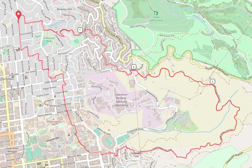
a small road, continue up a short hill and through another parking lot and shortly to a large log
bench and an entrance to the Strawberry Canyon Fire Trail.
Right: Many lizards are
visible in the sunny patches of the stairs up to MSRI
Make a right down this scenic dirt trail and
follow it for about a mile, then stay on it as it loops
around the canyon with views down to the University
and the campanile. Stay right at any trail
intersections so as not to end up on the upper fire
trail. Another mile and a half, the trail will take you to
a very steep hill. You’ll know it when you see it, since
it is so much steeper than any other part of the trail.
Descend this, then make a left off the trail and an immediate right down Panoramic Way. Where
the road curves, make a slight right down Arden Path. (There is a street sign, so it isn’t hard to
find.) At the bottom of the path,
stay right and descend the
steep, hand-railed, Arden
Steps.
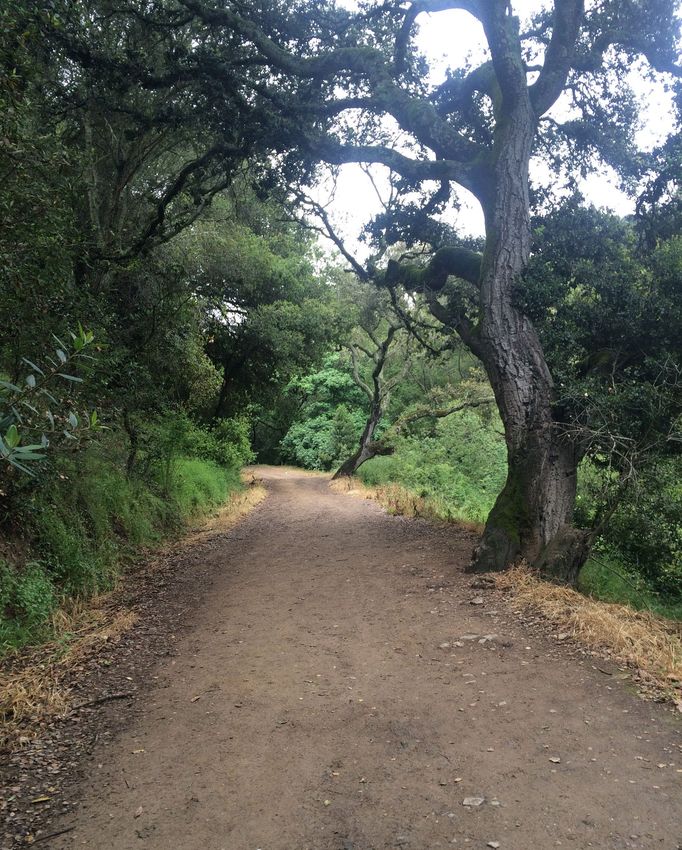
Left: The Upper Strawberry
Canyon Fire Trail, namesake
and highlight of the walk
Make a left at the
bottom on Mosswood Rd, then
make a slight right where the
road curves onto Mosswood
Lane, which is also signed.
This path takes you gradually
down through redwoods on a
dirt trail and ends at one of only
three “path intersections” in
Berkeley. Here, turn right down
Orchard Lane, then right on
Panoramic War, then left on
Bancroft Way. After a block,
continue straight to go down
Bancroft Steps and then take
Bancroft the street another
block down from where it
restarts at the bottom of the
path.
Step It Up: An Adventurer’s Guide to Forty Walks on the Paths, Trails, and Streets of Berkeley and Beyond 123
© 2019 by Jacob Lehmann Duke and Zeke Gerwein. All rights reserved.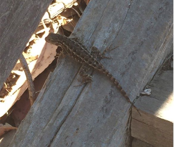
At Piedmont, Bancroft jogs to the right; follow it down one more block to College, then
turn right into UC Berkeley. There are many ways through the campus. Just walk along any
paths that look nice and try not to go too far left, just straight ahead and, if necessary, to the
right. If you come out on Gayley Rd, which runs east of the university, turn left, then left again at
Hearst. If you come out on Hearst, which ideally you should, take it to LeRoy, which is one block
below Gayley Rd. and one block above Euclid. Cross Hearst and head north on LeRoy. Where
it dead-ends, go up LeRoy Steps to connect to Hilgard. Turn right, then left shortly after at the
spot where LeRoy restarts. When LeRoy curves for the second time past the German school,
stay left to go down Hill Ct. Steps. There is a street sign so it should not be hard to find. The
steps end at the top of Hill Ct, unsurprisingly. Head down this tiny dead-end road to Euclid Ave.
and make a right. Cross Euclid at Buena Vista but continue heading north until Vine Lane, a
path. Here, make a left (unless you started at Euclid and Eunice, in which case you should
continue straight four blocks to finish your loop), noticing the ornate sign as you pass under it. At
the bottom of the path, go right, then make your first left down Hawthorne Steps. Again, go right
at the bottom then make your first left, this time on Rose St. Take Rose one block to Arch, go
right a block to Glen, and go left a block to Spruce. Turn right on Spruce to climb three blocks
back to the starting point.

Step It Up: An Adventurer’s Guide to Forty Walks on the Paths, Trails, and Streets of Berkeley and Beyond   124
© 2019 by Jacob Lehmann Duke and Zeke Gerwein. All rights reserved.
You can also read