Th e Moody Atlas of the Bible - Barry J. Beitzel - Cartographer: Nick Rowland F. R. G. S.
←
→
Page content transcription
If your browser does not render page correctly, please read the page content below
The Moody Atlas
                      of the Bible
                           Barry J. Beitzel

                      Cartographer: Nick Rowland F. R. G. S.

00 Prelims.indd i                                              8/5/09 08:55:51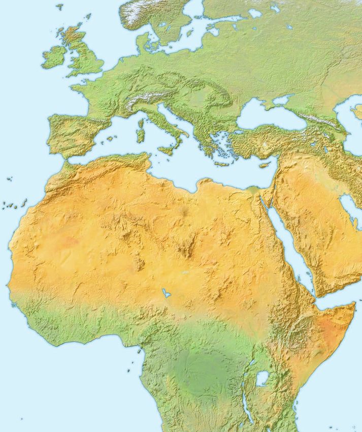
© 2009 by BARRY J. BEITZEL
                                                    THE MOODY BIBLE INSTITUTE OF CHICAGO

                          All rights reserved. No part of this book may be reproduced in any form without permission in writing
                             from the publisher, except in the case of brief quotations embodied in critical articles or reviews.

                                Unless otherwise indicated, the Scripture translation used in this book is the author’s own.

                                         Scripture quotations marked kjv are taken from the King James Version.

                                     Scripture quotations marked asv are taken from the American Standard Version.

                            Scripture quotations marked niv are taken from the Holy Bible, New International Version®. niv®.
                     Copyright © 1973,1978,1984 by International Bible Society. Used by permission of Zondervan. All rights reserved.

                        Scripture quotations marked tniv are taken from the Holy Bible, Today’s New International Version tniv®.
                       Copyright© 2001, 2005 by International Bible Society. Used by permission of Zondervan. All rights reserved.

                                                                ISBN: 978-0-8024-0441-1

                                                             Design © 2009 by Bounford.com

                                           Worldwide co-edition organized and produced by Lion Hudson plc
                                                                  Wilkinson House
                                                                  Jordan Hill Road
                                                                  Oxford OX2 8DR
                                                                      England
                                                                Tel: +44 (0) 1865 302750
                                                                Fax: +44 (0) 1865 302757
                                                              email: coed@lionhudson.com
                                                                 www.lionhudson.com

                                 We hope you enjoy this book from Moody Publishers. Our goal is to provide high-quality,
                               thought-provoking books and products that connect truth to your real needs and challenges.
                           For more information on other books and products written and produced from a biblical perspective,
                                                     go to www.moodypublishers.com or write to:

                                                                    Moody Publishers
                                                                 820 N. LaSalle Boulevard
                                                                    Chicago, IL 60610

                                                                    1 3 5 7 9 10 8 6 4 2

                                                                     Printed in China

00 Prelims.indd ii                                                                                                                      15/6/09 11:57:09
To Carol, my closest and dearest friend,
                      my sure companion on the journey of faith
                           and on the journey to the sites.

00 Prelims.indd iii                                               8/5/09 08:56:00
CONTENTS
             Preface                                                        10       Searching for Mt. Sinai in the Northern
                                                                                        Sinai Peninsula                                110
             CHAPTER 1: THE PHYSICAL GEOGRAPHY                                       Searching for Mt. Sinai in Southern Sinai         112
                OF THE LAND                                                13
                                                                                     Continuing the Israelites’ Route                  113
             Role of Geography in Understanding History                    14
                                                                                 Israel’s Occupation of Transjordan                    115
             Role of Geography in Understanding the Bible                   16
                                                                                 The Battles of Jericho and Ai/Bethel                  116
             A Geographical Introduction to the World of Palestine          18
                                                                                 The Battle of Gibeon                                  118
                    As a Component of the Fertile Crescent                  18
                    As a Land Prepared by God                               24   The Battle of Hazor                                   120
                    Historical Terminology                                  29   The Tribal Distribution of the Land                   122
                    Geopolitical Districts                                  32   The Levitical Cities and Cities of Refuge             124
             Geographical Overview of the Land of Biblical Israel’s              An Analysis of Israel’s Settlement of Palestine       126
              Territorial Inheritance                                       40       Recent Intriguing Discoveries                     126
                    The Land’s Physical Topography                          40   Egypt Campaigns into Canaan                           131
                    The Land’s Geology                                      56       Thutmosis III                                     131
                    The Land’s Hydrology                                    58       Amenhotep II                                      131
                    The Land’s Climate                                      64       Seti I                                            132
                    The Land’s Forestation                                  66       Merneptah                                         132
                    Cities in the Biblical World                            67       Shishak                                           132
                    Proper Identification of Ancient Cities                  72
                                                                                 The Era of the Judges                                 134
                    Roadways and Transportation in the Biblical World       76
                                                                                 Othniel, Ehud, and Samson                             137
                    Difficulties of Ancient Travel                            81
                                                                                     Othniel                                           137
                    The Location of Major Roadways                          84
                                                                                     Ehud                                              138
                    Travel by Sea                                           86
                                                                                     Samson                                            138
             CHAPTER 2: THE HISTORICAL GEOGRAPHY                                 The Judgeship of Deborah and Barak                    139
               OF THE LAND                                                 87
                                                                                 The Judgeships of Gideon and Jephthah                 141
             Garden of Eden                                                88
                                                                                 The Movements of the Ark                              143
             The Table of Nations                                           91
                                                                                 The Wars of King Saul                                 145
                    The Fourteen Descendants of Japheth                     91
                    The Thirty Descendants of Ham                           92   The Kingdom of Saul                                   148

                    The Twenty-six Descendants of Shem                      96   David and Goliath                                     150

             The Migrations of the Patriarchs                               98   David the Fugitive                                    151
                    The Wanderings of the Patriarchs                       100   The Battle of Mount Gilboa                            153
             Abraham in Palestine                                          101   The Exploits of King David                            155
             The Patriarchs in Palestine                                   104   Solomon’s International Trading Networks              159
             The Route of the Exodus                                       106       Tarshish: A Real Location                         159
                    The Historical Background                              106       The Ships of Tarshish                             162
                    The Geographic Setting                                 106       Evidence for 10th-century b.c. Phoenician Trade
                                                                                        on the Mediterranean                           164
                    The Israelites Beside the Sea                          108
                    Searching for Mt. Sinai in Saudi Arabia/South Jordan   109   Solomon’s Domestic Administration                     166

                                                                                                                                             v

00 Prelims.indd v                                                                                                                                9/6/09 10:35:22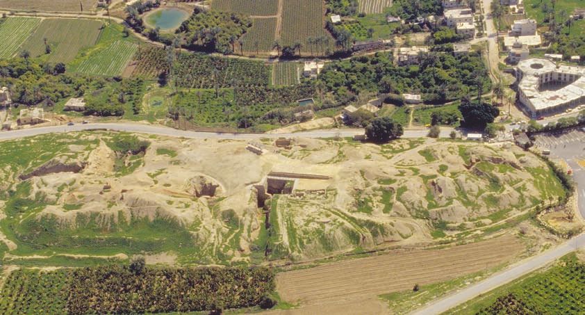
The Monarchy Divides                                 168   The Roman Empire                                232
                     Rehoboam’s Fortified Cities                           171   The Rise of Herod the Great                     234
                     Judah and Jerusalem Besieged                         173   Jesus’ Early Years                              238
                     The Battle of Qarqar                                 177   Jesus’ Move to Capernaum                        241
                     The Exploits of Jehu against the House of Ahab       179   Jesus’ Journeys to Jerusalem                    246
                     Israel’s Prophets                                    181   Jesus’ Post-resurrection Appearances            248
                     The Assyrian Empire                                  183   The Jewish Diaspora at Pentecost                250
                     The Assyrian Campaigns against Israel and Judah      185   The Ministry of Peter and Philip                251
                     The Battle of Carchemish                             189       Philip                                      251
                     Jerusalem Falls to Babylonia                         191       Peter                                       251

                     Jewish Deportations and Returns                      194   Extensive Travels of the Apostle Paul           253

                     The Babylonian Kingdom                               196   Paul’s Missionary Journeys                      254
                                                                                    Paul’s First Missionary Journey             254
                     Jeremiah Is Taken to Egypt                           198
                                                                                    Paul’s Second Missionary Journey            257
                     Judea after the Exile                                201
                                                                                    Paul’s Third Missionary Journey             261
                     The Persian Empire                                   203
                                                                                    Paul’s Voyage to Rome                       263
                          Cyrus II                                        203
                                                                                The Seven Churches of Asia                      266
                          Cambyses II                                     203
                                                                                The First Jewish Revolt                         268
                          Darius I Hystaspes                              203
                          Xerxes I                                        206   The Spread of Christianity in the Roman World   271
                          Darius II Nothus                                206
                     The Campaign of Alexander the Great against Persia   207   Chapter 1 Notes                                 277

                     The Battle of Issus                                  212   Chapter 2 Notes                                 280

                     Hellenistic Cities in Palestine                      214   Map Citation Index                              292

                     The Maccabean Revolt                                 216   Scripture Citation Index                        297

                     Jerusalem Through the Ages                           220   General Index                                   302
                          The Name                                        220   General Reading                                 304
                          Topography                                      222
                          Explorations and Excavations                    223
                          History                                         224

                     vi

00 Prelims.indd vi                                                                                                                    9/6/09 10:35:26
TABLE OF ABBREVIATIONS

             1QapGen   Genesis Apocryphon from Qumran cave 1               LXXA       Codex Alexandrinus
             1QM       War of the Children of Light against the Children   LXXB       Codex Vaticanus
                       of Darkness from Qumran cave 1                      LXXS       Codex Sinaiticus
             3Q15      Copper Scroll from Qumran cave 3                    MT         Mas(s)oretic Text [the Hebrew text of the Old
             4QEnd     Enoch fragment from Qumran cave 4                              Testament]
             4QSam     Samuel from Qumran cave 4                           Mt./Mts.   Mountain, Mountains
             Akk.      Akkadian                                            N./n.      Nahr [Hebrew word for river or stream]; or,
             Ar.       Arabic                                                         when used with Africa: North
             Aram.     Aramaic                                             PN         personal name [male or female; ancient,
             ARMT      Archives royales de Mari: transcriptions et                    classical, medieval or modern]
                       traductions.                                        R./r.      River
             Br.       Brook                                               RN         royal name [male or female; a non-Israelite/
             ca.       circa [approximately]                                          Judahite monarch]
             ch.       chapter(s)                                          RNn        royal name [a king of Israel (the northern
             DN        divine name [male or female]                                   kingdom) during the divided monarchy]
             EA        siglum for the Tell el-Amarna tablets               RNs        royal name [a king of Judah (the southern
             Eg.       Egyptian                                                       kingdom) during the divided monarchy]
             ELS       D. Baldi, ed., Enchiridion Locorum Sanctorum.       SP         Samaritan Pentateuch
                       Documenta S. Evangelii Loca Respicientia.           ss         superscription [heading found at the beginning
                       Jerusalem: Franciscan Printing Press, 1982.                    of many Psalms]
             EN        ethnic name                                         Sum.       Sumerian
             Gk.       Greek                                               T.         Tel/Tell [Hebrew/Arabic word for artificial
             Heb.      Hebrew; or, in the context of a scriptural                     earthen occupational mound]
                       citation: Hebrews                                   Ug.        Ugaritic
             J.        Jebel [Arabic word for mountain]                    Vulg.      Vulgate
             Kh.       Khirbet [Arabic word for ruins]                     W./w.      Wadi [Arabic word for intermittent water
             L.        Lake                                                           channel]
             Lat.      Latin
             LXX       A. Rahlfs, ed., Septuaginta. Stuttgart:
                       Württembergische Bibelanstalt, 1962.

                                                                                                                                   vii

00 Prelims.indd vii                                                                                                                      8/5/09 08:56:02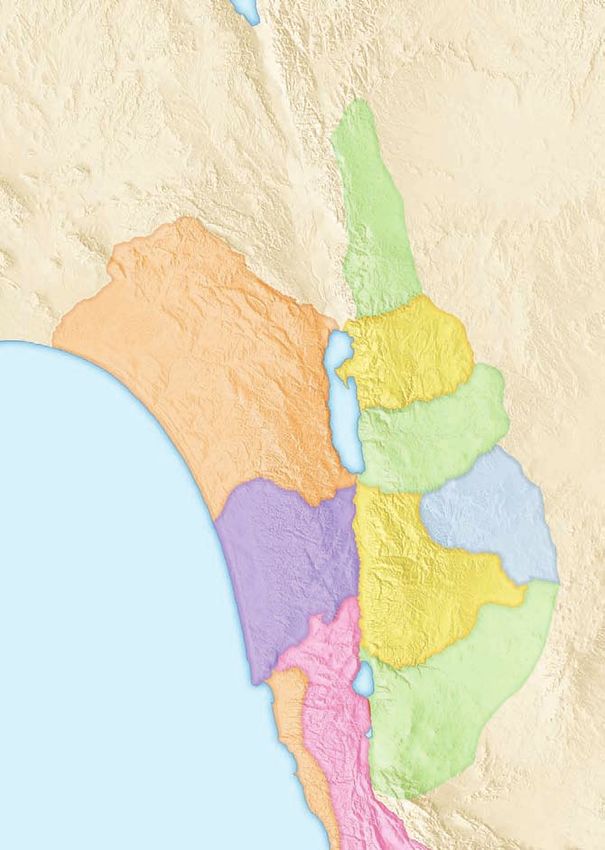
MAPS AND FIGURES
                       Geographical Barriers and the Ancient World         20   The Battle of Gibeon                                 119
                       Mesopotamia                                         22   The Battle of Hazor                                  121
                       The Levant                                          25   The Tribal Distribution of the Land                  123
                       Theological Borders of the Holy Land                27   The Levitical Cities and Cities of Refuge            125
                       Districts of the Old Testament                      33   An Analysis of Israel’s Occupation of Palestine: A   128
                       Districts of the New Testament                      37   An Analysis of Israel’s Occupation of Palestine: B   129
                       The Strategic Location of Palestine                 41   Egypt Campaigns into Palestine                       133
                       The Geographical Regions of Palestine               43   The Era of the Judges                                135
                       The Elevation of Palestine                          45   The Israelites Attack Gibeah                         136
                       The Jezreel Valley                                  46   The Judgeships of Othniel and Samson                 137
                       Samaria                                             47   The Judgeship of Ehud                                138
                       The Shephela Region                                 49   The Judgeship of Samson                              138
                       The Afro-Arabian Fault Line                         50   The Judgeship of Deborah and Barak                   140
                       The Sea of Galilee                                  53   The Judgeship of Gideon                              141
                       The Dead Sea                                        55   The Judgeship of Jephthah                            142
                       The Geology of Palestine                            57   The Movements of the Ark                             143
                       The Soils of Palestine                              59   The Wars of King Saul                                146
                       The Mountains and Rivers of Palestine               61   The Battle of Michmash                               147
                       Precipitation in Palestine                          63   The Kingdom of Saul                                  149
                       The Atmosphere of the Middle East in Summer         64   David and Goliath                                    150
                       The Atmosphere of the Middle East in Winter         65   David the Fugitive                                   152
                       Major Cities of Palestine                           68   The Battle of Mount Gilboa                           154
                       Major Archaeological Sites of the Biblical World    74   The Battle of the Valley of Rephaim                  155
                       Major Archaeological Sites of Palestine             77   The Exploits of King David                           157
                       Transport Routes of the Biblical World              78   The Kingdoms of Saul, David, and Solomon             158
                       Sea Routes of the Greco-Roman World                 82   Solomon’s International Trading Networks             160
                       The Roads of Palestine                              85   Solomon’s Domestic Initiatives                       165
                       The Garden of Eden                                  89   Solomon’s Domestic Administration                    167
                       The Table of Nations                                93   The Monarchy Divides                                 169
                       Migrations and Wanderings of the Patriarchs         99   Rehoboam’s Fortified Cities                           171
                       Abraham in Palestine                               102   Judah and Jerusalem Besieged                         174
                       The Patriarchs in Palestine                        105   The Vulnerability of Judah and Jerusalem             175
                       The Israelites leave Egypt                         107   The Battle of Qarqar                                 177
                       The Route of the Exodus                            110   The Exploits of Jehu against the House of Ahab       179
                       The Journey of the Spies                           114   The Ministries of Elijah and Elisha                  180
                       Israel’s Occupation of Transjordan                 115   Israel’s Prophets                                    181
                       The Battles of Jericho and Ai/Bethel               117   Renaissance During the Divided Monarchy              182

                       viii

00 Prelims.indd viii                                                                                                                       9/6/09 10:35:26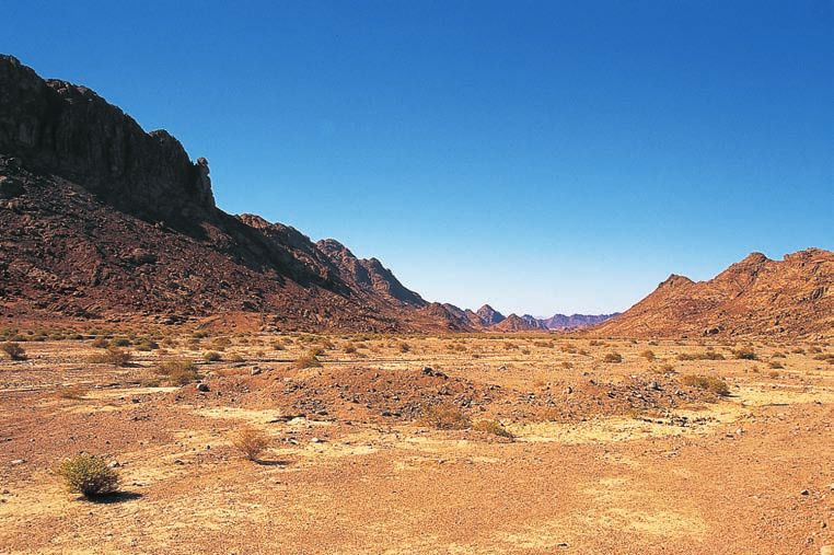
The Assyrian Empire                                  184   Modern Jerusalem                                231
             Assyria’s Earlier Campaigns against Israel           185   The Roman Empire                                232
             Assyria’s Later Campaigns against Israel and Judah   186   The Rise of Herod the Great                     235
             Palestine after the Fall of the Northern Kingdom     187   The Kingdom of Herod the Great                  237
             The Battle of Carchemish                             189   Jesus’ Early Years                              239
             Jerusalem Falls to Babylonia                         193   Jesus’ Ministry in Galilee                      243
             Jewish Deportations and Returns                      195   Jesus’ Ministry in Palestine                    244
             The Babylonian Kingdom                               197   Jesus’ Journeys to Jerusalem                    247
             Jeremiah Is Taken to Egypt                           198   Jesus’ Post-resurrection Appearances            249
             Ezekiel’s Vision of the Land                         200   The Jewish Diaspora at Pentecost                250
             Judea after the Exile                                202   The Ministry of Peter and Philip                252
             The Persian Empire                                   204   The Early Travels of the Apostle Paul           255
             The Greek Empire                                     208   The Strategic Location of Antioch               256
             Alexander Marches through Palestine                  211   Paul’s First Missionary Journey                 257
             The Battle of Issus                                  213   Paul’s Second Missionary Journey                259
             Hellenistic Cities in Palestine                      215   Paul’s Third Missionary Journey                 261
             The Maccabean Revolt                                 217   Paul’s Voyage to Rome                           265
             The Maccabean Kingdom                                218   The Seven Churches of Asia                      267
             Old Testament Jerusalem                              221   The First Jewish Revolt                         269
             New Testament Jerusalem                              225   The Spread of Christianity in the Roman World   272
             Jesus and Jerusalem                                  227   Early Christian Communities in Palestine        275
             The Roman Destruction of Jerusalem                   229   The Borders of Modern Israel                    276

                                                                                                                              ix

00 Prelims.indd ix                                                                                                                 9/6/09 10:35:27
PREFACE

                    “Geography is a flavor.” Thus Starbucks proclaims as a                  The essence of geography has imbued the biblical storyline
                    banner on its sales displays around the world or on the side       with a distinctive flavor. It is not the flavor of most of North
                    of a one pound bag of its coffee. The market strategy of the        America, Europe, or much of the rest of the world, but it
                    international conglomerate continues by affirming: You can tell      is nonetheless a robust and full-bodied flavor, one that is
                    a lot about a coffee if you know where it’s from, because every     a function of a peculiar geography. Capturing this flavor
                    bean has a distinctive flavor particular to its land of origin.     will depend to a large extent on one’s ability to recover and
                    Coffees from Arabia are legendary for their berrylike flavors        assess the Bible’s particular geographical horizon. St. Jerome,
                    and winelike qualities. Those from Africa are remarkable           who lived in this Land for many years, wrote concerning
                    for their floral aromas and citrusy tastes. Coffees from Latin       geography’s role in the enterprise of biblical interpretation:
                    America are celebrated for their great balance, medium body,       “Just as those who have seen Athens understand Greek history
                    tangy brightness, and consistent quality. And those from Asia-     better, and just as those who have sailed from Troy . . . to
                    Pacific are popular for smooth, earthy, and exotic flavors, with     Sicily, and from there to Ostia Tiberias [Rome’s port on the
                    low acidity and full body.                                         Tyrrhenian Sea, fully developed in the 2nd century a.d. by
                        A similar claim can be made with respect to the biblical       the emperor Hadrian; see map 26] understand better the 3rd
                    storyline: it exudes a distinctive flavor that is particular to     Book of (the poet) Virgil, so one who has seen the land of
                    the Land where it originated. Much of the biblical storyline’s     Judah with his own eyes or has become personally acquainted
                    character and aromatic quality reflect the specific geographic       with the historical references to the ancient towns . . . will
                    realities at the place of its birth and enactment. Thus for        surely comprehend the Holy Scriptures with a much clearer
                    example, the Land of God’s covenantal promises might have          understanding.”1 Geography does play a critical role and does
                    been created with the aroma of an environment without              make a decisive difference, whether one has in mind the
                    blemish; it might have been permeated with the flavor of            particular scent of a coffee bean or the distinctive flavor of a
                    ecological or climatological perfection. It might have been        biblical storyline!
                    endowed with the taste of a tropical rain forest through which         Geography is understood in the Atlas to define three
                    coursed an effusion of crystal-clear waters; it might have been     separate, if somewhat overlapping concepts: physical
                    brought into existence with the texture and brightness of a        geography (a description of those topographic and
                    thickly carpeted grassy meadow or the scent of an elegant          environmental features that characterize and embody the
                    garden suffused with the pungent fragrance of blossoms,             land), regional geography (a description of those political
                    mosses, and flowers. It might have been—but it was not.             and territorial subdivisions that comprise the land), and
                    As I will attempt to demonstrate, this Land of promise that        historical geography (a diachronic unfolding of those events
                    God prepared as the stage on which his storyline would be          that have transpired in the land, which are conducive to a
                    enacted is a locale that embodied the direst of geographic         geographical explanation). Chapter one of the Atlas addresses
                    and environmental hardship. Innately possessing meager             aspects of physical geography, as well as setting forth many
                    physical and economic resources, and positioned where it           of the major parameters of regional geography; chapter two
                    was caught inescapably in a maelstrom of relentless political      seeks to present an overview of historical geography. It is
                    upheaval, this Land has yielded up to its residents a simple,      not my purpose in chapter two to supply a full and running
                    tenuous, mystifying, and precarious existence throughout the       commentary on the whole of the biblical narratives discussed,
                    biblical epoch, even under the best of circumstances. It is an     which would require separate volumes in themselves, but only
                    important and helpful insight to recognize that God prepared       to provide a geographic sketch sufficient to elucidate a given
                    a certain kind of land, situated at a particular location,         map. To a certain degree, chapter two adheres to the aphorism
                    fashioned to elicit a specific and appropriate response. This is    of Thomas Fuller: “ . . . the eye will learn more in an hour from
                    not to say that I believe the Bible was designed to teach the      a Mappe, than the eare can learn in a day from discourse.”2
                    subject of geography, or any other of the sciences. It is merely       Anyone today who wishes to write on the biblical world
                    to observe that the Bible often characteristically transmits its   faces the vexed question of nomenclature, but this issue is
                    storyline through the geographic medium. To the degree one         perhaps most acute and protracted for the geographer. Given
                    appreciates the flavor and parameters of the medium, so also        the climate of contemporary Middle Eastern politics, it
                    one should be able to understand more fully the revelatory         becomes almost impossible for the Bible geographer to employ
                    import and texture of a given biblical text.                       certain words—e.g., Israel/Palestine, Jordan/Transjordan, West

                    x           The Moody Atlas of the Bible

00 Prelims.indd x                                                                                                                                      8/5/09 08:56:03
Bank/Samaria-Judea, Gulf of Aqaba/Gulf of Elat, Persian Gulf/         Jebel el-Magharah). Finally, frequently cited bodies of water that
             Arabian Gulf, or even Armenia or Syria, etc.—without creating         serve as important geographical points of reference on a map
             the impression that a certain political statement is being            have been assigned a static spelling throughout the volume (e.g.,
             made or a particular nationalist or religious ideology is being       Mediterranean Sea, not also Upper Sea, Great Sea, Western
             endorsed.3 With this reality in mind, I wish at the outset to         Sea, Great Syrian Sea, Great Green Sea, Mare Internum, Mare
             state as candidly and clearly as I know how to my readers—be          Nostrum, Sea of the Maiden, Sea of Isis, or tâmtu elītu; Dead
             they Christian, Jewish, or Muslim—that my agenda is purely            Sea, not also Salt Sea, Sea of the Arabah, Mare Maledictum,
             historical and that when I use these or other such terms, even        al-bahaire el-maita, Devil’s Sea, Stinking Sea), even though such
             in a post-biblical or a modern context, their use should not be       spellings will admittedly be anachronistic on some maps. In a
             construed as espousing any particular contemporary political          similar vein, historical periodization indicated by terms such as
             or ecclesial conviction.                                              “(Late) Bronze Age” or “(Early) Iron Age” reflects a classification
                 Another problem faced by any author of an Atlas is the            of architectural forms and/or decorative styles of ancient
             tension between the area covered by a map and the scale at            pottery. It has nothing to do with metalworking or any other
             which it can be covered. If the area to be covered is large,          form of metallurgic technology.
             then the scale must be small, or else the map will not fit on              Beyond those common abbreviations found in the Table of
             the size of a printed page. But this can make for an extremely        Abbreviations, individual maps show abbreviations, symbols,
             vague and imprecise map. Alternatively, if the map were to            and explanatory boxes in the legend and sometimes on the
             be composed at a large scale, then the area covered must be           body of the map itself. Use of the question mark, traditionally
             small, or again the map will be larger than page size. Now the        employed on Bible maps to denote cities of uncertain location,
             map can be extraordinarily detailed but may lack the larger           has been avoided in the Atlas because of irritation or even
             perspective or be without fixed geographic points. My effort            possible confusion to the reader. By this, however, I do not
             here has been to keep the scale as large as possible and yet to       wish to imply certainty where the identity of a site remains in
             avoid cropping off an important section of a map or placing an         doubt. Instead of a question mark, I have uniformly used the
             arrow that points off the map toward a designated spot. On a           symbol [ ] for a city whose location is judged to be uncertain; it
             few occasions, however, to have an arrow pointing seemingly           was thought that this symbol is both less conspicuous on a map
             to the margin of a page was unavoidable, though admittedly            and less susceptible to misinterpretation.
             this can be an irritating practice. Of similar practices, Plutarch        Among the back matter, the reader will encounter three
             once complained: “Geographers . . . crowd onto the edges of           Indexes (Map Citation Index, Scripture Citation Index,
             their maps parts of the world which elude their knowledge,            General Index). The Map Citation Index is organized
             adding notes in the margin to the effect that beyond this lies         according to map number, not page number (for a complete
             nothing but sandy deserts without water and full of wild beasts,      list of maps arranged according to page number, refer to the
             unapproachable bogs, or frozen sea.”4 I trust that my readers will    Table of Maps and Figures found among the front matter).
             be more understanding. But my approach to this problem of             It should be stressed that the Map Citation Index is not a
             area covered versus scale has sometimes necessitated that a map       Gazetteer (a comprehensive index of all geographic names
             legend be positioned adjacent to, but not on, the map itself.         referenced in the Bible, sometimes including information
                 Complexities of phonetics between several writing systems         concerning the pronunciation of each entry, together with
             used in the biblical world are profound, and a certain amount         a description of its present location and name); inasmuch
             of inconsistency in the spelling of proper names is unavoidable.      as Gazetteers already exist in a variety of readily accessible
             Nevertheless, a measure of systemization has been attempted.          versions and formats, there seemed to be no need to
             Names that have a well-known English form have been retained          reinvent the wheel. The Scripture Citation Index is arranged
             in the Atlas (e.g., Jerusalem, Babylon, Greece); names that are       according to page number in the Atlas; it is also keyed to
             generally transliterated into English in a certain form retain that   English versification, which is sometimes at variance with
             customary form here (e.g., Akkad, Tyre, Aleppo, Carchemish),          the versification of the MT. The General Index intends to
             even though the transliteration may be slightly imprecise; names      include many proper names and major subjects addressed in
             not occurring in English are rendered phonetically in English         the text, with some limitations. Thus for example, frequently-
             script (e.g., Negeb, Wadi Far`ah, Kafr Bir’im), normally without      cited biblical characters (e.g., Abraham, David, Jesus) are not
             vowel length marks or diacritical indicators (note that both          included in the Index, since there are whole blocks of maps/
             length marks and diacritical signs are used where feasible when       text dedicated to these individuals (in such cases, refer to the
             transcribing words that are not proper names). Arabic names           Table of Maps and Figures found among the front matter).
             may be spelled with or without the definite article (el- or al-,       Likewise, frequently referenced classical writers (e.g., Josephus,
             but often assimilated into the sound of the following consonant)      Pliny) are not included in the Index, as the relevant source data
             (e.g., Tell el-Amarna, not Tell Amarna, or Jebel Magharah, not        are documented in the Notes. Also, I have deliberately limited

                                                                                                                              Preface              xi

00 Prelims.indd xi                                                                                                                                      8/5/09 08:56:04
the number of geographical names in the General Index, responsibility alone. Finally, I shall never be able to estimate
hoping to minimize overlap with corresponding information fairly, much less to repay, the debt of gratitude that I owe my
contained comprehensively in the Map Citation Index. Names wife and family. Without their joyful sacrifices of time, and
of most foreign monarchs have been subsumed in the General their steadfast patience and encouragement since its inception,
Index under their national identity (e.g., Assyrian monarchs, this project could never have been brought to consummation.
Persian monarchs, Roman emperors), but all other data have For myself, the study of geography culminates in doxology.
been arranged alphabetically. I confess to resonating with the prophetic declaration: “That
Finally, this Atlas could never have become a reality without which fills the whole earth is his glory” (Isa. 6:3b), or with the
the diligent labor of a host of individuals, and my thanks to them analogous refrain found on the lips of the psalmist:
here is more than a mere accommodation to tradition. These
include Greg Thornton, Vice President at Moody Publishers; “Let us come into his presence with thanksgiving;
Dave DeWit, project co-ordinator at Moody Publishers; Tim let us make a joyful noise to him with songs of praise!
Dowley, London, Project Editor; Nick Rowland, Cambridge, For the Lord is a great God
England, cartographer; and Nick Jones, co-edition coordinator, and a great King above all gods.
at Lion Hudson, Oxford, England. All maps are new and The depths of the earth are in his hand;
digitized. The text has been completely rewritten and greatly the mountain peaks also belong to him.
expanded, with ample supporting documentation provided. The sea is his, for he made it;
I wish to communicate thankfulness to the Board of and his hands formed the dry land.
Regents of Trinity Evangelical Divinity School, whose Come, let us worship and bow down,
mission-minded sabbatical program has substantially helped let us kneel before the Lord, our Maker!
to undergird and sustain a project of this breadth and scope. I For he is our God,
also express profound indebtedness to my Teaching Assistant, and we are the people of his pasture,
Mr. A. D. Riddle, who has invested countless hours and the sheep under his care” (Ps. 95:2–7a).
concentrated energies in checking my work and in preparing
the Indexes. And to Professors Davis Young, Walter Kaiser, Baalbek, Lebanon
James Hoffmeier, and Douglas Moo, who read parts of the May,
manuscript and offered helpful insight and counsel, I express
sincere appreciation. Naturally, any remaining errors are my
ENDNOTES
1 St. Jerome, “Praefatio Hieronymi in librum Paralipomenon juxta LXX Interpretes,” in J.-P. Migne, ed., Patrologiae cursus completus: 3 e.g., the National Geographic Atlas of the World [8th edition] was widely accused of displaying political bias by using the name
omnium SS. patrum, doctorum scriptorumque ecclesiasticorum, Patrologiae Latinae 29, (Turnhout, Belgium: Brepols, 1880), 423a, “Persian Gulf,” with the words “Arabian Gulf” appearing in brackets beneath. A delicate geographical issue not limited to the
author’s translation. Middle East, Rand McNally’s World Atlas [7th edition] experienced significant fallout from its primary use of “Peking” [and not
2 Thomas Fuller, A Pisgah-sight of Palestine and The Confines thereof, with the Historie of the old and new Testament acted thereon, “Beijing”].
(London: J. Williams, 1650), 3. 4 Plutarch, Lives: Theseus 1.1, author’s translation.
xii The Moody Atlas of the Bible
00 Prelims.indd xii 8/5/09 08:56:06CHAPTER 1
The Physical
Geography of the Land
01 Chapter layout.indd 13 8/5/09 08:47:38ROLE OF GEOGRAPHY IN
UNDERSTANDING HISTORY
Western civilization has commonly embraced the logic of inconsequential that the Roman Empire was able to expand
Greek philosophical categories and has endeavored to describe as far as the Danube and Rhine rivers, a boundary which
cosmic realities in terms of “time and space.” Individuals, for part of the 20th century also corresponded to the Iron
ideas, movements, and even the courses of nations are often Curtain. Even in 21st-century America, virtually every major
interpreted precisely in accordance with these canons. Hence, commercial and industrial city has an outlet to river, ocean, or
designations are invariably employed in analyzing civilizations the Great Lakes network. Those few exceptions are located at
past and present: pre-/post-, Early/Late, b.c./a.d., East/West, the hub of important interstate highways or airline routes.
Oriental/Occidental, Near East/Far East/Middle East.1 (Note Other factors of geography, such as earthquake activity
the first word in this paragraph!) and volcanic eruption, have likewise played their part in
Christian theology itself has not escaped such an fashioning history.3 It is axiomatic that the face of much of
encompassing mode of thinking: God may be described in western Asia and eastern Africa has been formed through
terms that are corollary to time (infinity, eternality) or space seismic activity. A huge fissure in the earth’s surface has been
(omnipresence). And Christianity asserts that those attributes the single dominant factor in shaping the landscape of western
of deity were willingly relinquished by Christ through the Syria, Lebanon, Israel, Jordan, Ethiopia, Uganda, Tanzania,
drama of incarnation, when he became “locked in time and Mozambique, and the island of Madagascar. [See map 13.]
space.” Accordingly, even upon superficial reflection, one In western Asia, earthquake activity has always meant that
can begin to comprehend something of the far-reaching certain areas were inhospitable to human occupation, causing
significance of the temporal and spatial disciplines: history arterial travel to be funneled into an essentially north-south
and geography respectively. grid. The seismic forces that produced the mighty Himalayan
Moreover, history is in many respects inseparably bound chain, on the other hand, created what in antiquity was an
by and subject to geographic limitations. Geography is an impenetrable longitudinal barrier that caused culture to
impelling force that both initiates and limits the nature and expand and traffic to flow on an essentially east-west axis.
extent of political history, what we might call geopolitics. Vast badlands of congealed lava confront a potential settler
Geologic formation and rock type have a decisive effect on in a dreary terrain broken only occasionally by basaltic
altitude, manner and extent of erosion, location and quantity plugs or cinder cones, gaunt reminders of bygone volcanic
of water supply, and physical topography. These, in turn, activity. More important is the harsh reality that this volcanic
have a profound bearing on certain aspects of climate, raw activity often rendered the soil totally unsuitable for human
materials, soil formation, and land use—factors that may productivity. In antiquity it always presented a cruelly hostile
alternatively repel or attract human settlement and certainly environment that was intolerably painful to the limbs of pack
influence the location, density, and socioeconomic makeup animals, and thus precluded any sort of arterial traffic.
of a settlement. Where settlements are founded, roadways Volcanic eruptions can bring a segment of history to
are eventually opened and used by migrants, traders, or an abrupt termination. The image of Vesuvius’s eruption
armies, and culture ultimately arrives at a particular location. upon Pompeii in a.d. 79 often comes to mind. The 1815
Stated more succinctly, “With every step back in time, history eruption of Tambora on Indonesia created a casualty count
becomes more and more geographical until, in the beginning, of approximately 92,000 and produced an ash cloud in the
it is all geography.”2 upper atmosphere that reflected sunlight back into space
In short, factors of geography often dictate where and how and produced a year without summer. The 1883 eruption
geopolitics will occur. Surely it is geographically significant of Krakatoa was audible across one-third of the earth’s
that ancient civilizations emerged on the banks of rivers. surface, caused a tsunami that was perceptible in all oceans
Ancient Egypt owed its existence to the Nile; Mesopotamia of the world, adversely modified climate on a global scale for
drew its life sustenance from the Tigris and Euphrates; the several years, and killed more than 36,000 people. Yet in vivid
Indus Valley civilization was situated along the river by the contrast to all these events stands the eruption of the Greek
same name; the Hittite Empire rested astride the Halys; island of Santorini (Thera), located in the south Aegean Sea
Old Indian culture sprang to life in the Brahmaputra and approximately midway between mainland Greece and Crete.
Ganges river valleys; ancient China had its Yellow River and [See maps 111 and 112 for location.]
the Yangtze; and European culture emerged on the banks Santorini’s explosivity index at ground zero is calculated
of the Tiber, Thames, Danube, Rhine, and Seine. Nor is it to have been more than 15 times greater than the force of the
14 The Moody Atlas of the Bible
01 Chapter layout.indd 14 8/5/09 08:47:50atomic explosion over Hiroshima. In the wake of the colossal the gold of Spain, and the ivory of the African interior.
eruption that occurred on Santorini around 1525 b.c. (±100 And who can doubt that the whole complexion of modern
years, whether dated archaeologically or radiometrically), geopolitics has been dramatically altered by the OPEC
some 32 square miles of earth collapsed into a caldera of cartel? Indeed, geography represents the stage on which the
approximately 2,250 feet in depth. When the Aegean waters pageant of history is presented, without which history itself
rushed into this newly created and superheated chasm would wander about aimlessly as a vagrant.7 To paraphrase
(estimated to have been in excess of 2550° F.), a gigantic the aphorism commonly but probably erroneously ascribed
tsunami was formed that is estimated to have been as high to Will Durant, civilization exists by geographic consent,
as 800 feet at its apex. Within 20 minutes, this massive tidal subject to change without notice.8
wave—also propelling an enormous volume of searing, toxic Geography’s effect upon history extends also to the
gases—catastrophically struck Crete at an estimated speed of theoretical domain. Like the effect of environment on culture,
200 miles per hour and at a height of 200 to 300 feet.4 Pumice geography actually establishes the boundaries within which
laminated the vestige of Santorini with a volcanic deposit history must operate. Students of the effect of geography
ranging in depth from between 65 and 195 feet. A cloud of on history have made a most helpful distinction between
pumice, ash, and lava estimated at between 8.5 and 11.25 its determining effect and its limiting effect. Where a frigid
cubic miles in volume was thrust some 50 miles into the sky winter climate necessitates the wearing of heavy clothing,
where a predominantly northwesterly wind blew it toward there is nothing in the temperature itself that decrees whether
Crete. The thick blanket of falling ash would have created an people shall wear sealskins or Shetland wool, but they must
atmosphere of lethal air, producing polluted water, rancid procure and wear winter clothing. When a region unsuitable
food, and diverse diseases. What is more, basaltic cores the for agriculture somehow becomes populated, very little in the
size of a person’s head were hurled like missiles directly from environment predetermines which domestic animals shall
Santorini to Crete. Waterborne pumice fragments manifesting be grazed or whether food shall be secured with hooks, nets,
a Santorini origin have been found across the entire stretch traps, or spears, but a non-agrarian society will surely emerge.
of the eastern Mediterranean basin, even at inland places as It is geographically pertinent that places in the Near
far away as Israel and Egypt.5 It is not difficult to comprehend East manifesting the most ancient human habitation—
how the entire Minoan culture on Santorini was brought to a Mt. Carmel, Shanidar, Çatal Hüyük, Jarmo, Hacilar
disastrous, abrupt end, nor how a number of Minoan palaces [map 23]—are situated precisely in areas that receive an
on Crete were severely damaged and may even have been average annual rainfall capable of sustaining the spontaneous
destroyed at that time. generation of wild grains that can support human existence.
Mountains, deserts, and oceans have all influenced the It is also geographically pertinent that certain plants and
location or nature of geopolitics. Today’s newspapers often animals are peculiar to only one hemisphere, or that writing
contain lead stories having to do with the continental effects of arose where, when, and in the form that it did. These all
El Niño, salination, widespread famine and food shortages, or represent expressions of geopolitical history that have been
global warming. Some of those same geographic factors played and continue to be subject to the limitations and indirect
a profound role in ancient Near Eastern geopolitics. Famines controls of geography.
were often described in ancient literature, and scholars have Many of the same limitations are discernible even in our
amply demonstrated how climate fluctuations in antiquity had modern technological world, where deserts can be extensively
an adverse effect on ancient culture.6 irrigated or the effects of oppressive heat can be mitigated
A “Mediterranean theater” of history existed from the by air-conditioning; where Landsat photography equipped
demise of the Persian navy at the Battle of Salamis (480 b.c.) with infrared capability can discover vast reservoirs of fresh
until the defeat of the Spanish Armada (a.d. 1588). Northern water buried deep in the cavities of the earth’s interior, or
and southern shores regularly vied for political and cultural cloud-seeding and widespread irrigation can lessen the gravity
superiority. But after the oceanic voyages of Christopher of an arid environment; where rampaging rivers can be
Columbus, Vasco da Gama, and Ferdinand Magellan, the restrained by huge dams and even harnessed for hydroelectric
geopolitical sovereignty of the Mediterranean was challenged purposes; where formidable mountain barriers can be leveled,
as the Renaissance and some of its important cities began to penetrated, or easily surmounted; and where air travel can
fade and “history” moved westward. put faraway places within quick and convenient reach. One
Natural resources represent yet another geographic factor might imagine how much more defined and deeply etched
that has influenced the location and nature of geopolitics. such geographical limitations would have been in a world that
A wide array of ancient documentation explicitly addressed existed before such technological sophistication—one like the
the need to maintain control over the tin of Afghanistan, the biblical world.
cedar of Lebanon, the silver of Assyria, the copper of Cyprus,
The Physical Geography of the Land 15
01 Chapter layout.indd 15 8/5/09 08:47:50ROLE OF GEOGRAPHY IN
UNDERSTANDING THE BIBLE 9
Matters of “time and space” remain among the difficulties that ● “Wandering” (Num. 32:13; Hos. 9:17; Deut. 26:5b)—
vex a 21st-century student of the Bible. The proclamations A wanderer was someone en route to nowhere. He was
of Scripture were occasioned and penned from distinctive not just between stops, but actually had no specified
settings, yet modern students of the Bible live in a different destination or home.
millennium and adhere to a different worldview. Most live on ● “Going into exile” (2 Kings 18:11; Isa. 5:13; 49:21; Ezek.
a different continent. So in our desire to properly interpret and 39:23; Ezra 1:11)—An exile was someone who had been
apply the Bible, we must ensure as much as possible that our forcibly uprooted or disenfranchised from his own land
enterprise is built knowledgeably upon the grid of the Bible’s and obliged to live in another “place.”
own environment. At the outset, it is imperative for one to view
geography (space) as something more than a superfluity that Whether removed to Egypt, Babylon, or elsewhere,
can be arbitrarily divorced from biblical interpretation. To the landlessness was tantamount to hopelessness. Israel’s
contrary, the biblical portrait of both Israel and the Church is covenantal faith was very much based on and grounded in
painted on several levels, including the territorial level.10 events that transpired at certain places in this world. There
In point of fact, biblical narratives are often driven by the was an acute consciousness of a national home, a definable
notion of “space.” An incident may be said to have occurred on geographic domain in which even the soil was divinely
a certain hill, in a particular valley, on a discreet plain, at a given consecrated, what one may call “the holy land.”11 One can
town. At times the name of the place itself becomes an important rightly characterize Israel’s faith by its “here and now”
part of the revelation, frequently including a wordplay or pun on essence—one where the ascetic principle of 1 John 2:15–17
the name in order to reinforce the location of the event in public was largely absent.
consciousness. Occasionally an aspect of geography becomes a Similarly, in the New Testament gospels, much of the
theological axis around which an entire biblical book revolves, teaching of Jesus may be related to where he was situated at
or a large portion of a book is particularly rich in geographical the time. Jesus talked about “living water” while at Jacob’s
metaphor: for example, fertility and the book of Deuteronomy, well (John 4:10); He called himself the “bread of life” while at
forestation and the book of Isaiah, hydrology and the book of Capernaum, where basaltic grain mills were manufactured
Psalms, or agriculture and the book of Joel. Often it is precisely a (John 6:48); he declared Peter to be the “rock” against which
geographical reference or allusion that enables scholars to assign “the gates of Hades will not prevail” while in Caesarea Philippi,
a book to a place of origin (such as Amos in Israel’s northern a site otherwise known in the classical world for the Eleusian
kingdom, or James in the eastern Mediterranean basin). Oracles and the daughter of Demeter being carried off by
Perhaps even more profoundly, Jewish faith in the Old Hades, god of the underworld (Matt. 16:18); and he spoke
Testament was inextricably tied to space, and “land” became about faith that can move a mountain while on the road to
the prism of this faith. Land/space was an arena in which God Bethphage, from which his disciples could easily have looked
acted mightily on behalf of his people. (Consider the call and southward and seen evidence of a mountain that had been
covenant with Abraham and his descendants, the Exodus/Sinai physically “moved” by Herod the Great in order to construct
motif, the conquest/settlement of the land, the captivity away his palace/fortress site of Herodium (Matt. 21:21–22).
from the land, the return to the land, the New Israel.) Many of In a few instances Jesus appeared to go out of his way
God’s promises related directly to the original possession (or in order to teach a lesson at a particular location. On one
later restoration) of a particular parcel of real estate. It is not such occasion he told a parable about a certain nobleman
an overstatement to declare that, during its years of recorded who journeyed to a distant country in order to obtain
biblical history, Israel’s rootage in this “land” provided its faithful royal power. However, his appointment was opposed by a
their foundational identity, security, and even prosperity. delegation of local citizens, who had sent an embassy to state
When they were not in possession of their land, Israelites their objections to his reign. So, when he returned with his
were often described in terms that reflected the precarious newfound authority, this nobleman ruthlessly attacked those
connotations of landlessness, aimlessness, and estrangement: who had opposed him and had been disloyal to him (Luke
● “Sojourning” (Gen. 12:10; 15:13; 47:4; Ex. 6:4; Deut. 10:19b; 19:11–27). This “parable” is eerily reminiscent of real-life
26:5b; cf. Heb. 11:13)—A sojourner was a resident-alien events surrounding the eldest son of Herod the Great—
who did not belong and could not settle down to enjoy Archelaus. After Herod’s death in 4 b.c., Archelaus traveled
the privileges afforded the citizen. from Judea to Rome to obtain an “ethnarchy”—an official
16 The Moody Atlas of the Bible
01 Chapter layout.indd 16 8/5/09 08:47:51sanction to rule over a province. The Jewish historian Josephus that one may run afoul of the biblical argument or that reality
tells us Archelaus was awarded the title over the protest of may dissolve into sentimentalism.
more than 8,000 Jews in Rome, including a delegation that Armed with a geographical knowledge of the Bible, one is
had also traveled from Judea.12 After returning to Judea better able to understand references such as “the former and
with his new power, Archelaus wasted no time in ruthlessly latter rains,” “the strong east wind,” or “a land flowing with milk
extracting vengeance on his detractors. Josephus also wrote and honey.” Similarly, one can better appreciate the scorching
that Archelaus focused much time and attention on the New effect of Israel’s hot sun; the implications of “no rainfall” and
Testament city of Jericho and its immediate environs: he the importance of dew for crop survival; the prevalence of
rebuilt the Herodian palace at Jericho in splendid fashion, he fertility (Baal) worship; the nature of Egyptian, Canaanite, and
built a town near Jericho that he named for himself, and he Mesopotamian deities; the migrations of Abraham, Moses,
diverted irrigation waters to his date-palm plantations located and Nehemiah; the terrain Joshua’s forces could conquer
only two miles from Jericho.13 but over which the Philistines could not run their chariots;
It is of interest to note that Jesus told his parable as he was the astounding success of David in eluding Saul’s manhunt;
departing Jericho en route to Jerusalem, which means that his the social psychology of the ministry of John the Baptist;
listeners would have been on the Roman road bordering the the motivation(s) behind Jesus’ astute move from Nazareth
recently reconstructed Herodian palace and adjacent to the to Capernaum; and the staggering distances traveled by the
irrigation channels that carried water out of the Judean hill apostle Paul. In addition, the pronouncements of the prophets
country to Jericho and its environs. Indeed, many of Jesus’ make more sense as they predicted a stunning day to come
teachings are arguably related to his distinctive geographical when valleys will be lifted, mountains will be lowered, uneven
surroundings. He talked about various kinds of soil, the east and rough ground will be made level and smooth, and even
wind, the flowers of the field, and branches abiding in vines. when the water of the Dead Sea will become crystal clear and
One later observes a geographical correlation between the nourish abundant sea life.
uniquely centrifugal form of Jesus’ Great Commission in Acts Cultivating a spatial awareness is a necessary and valuable
1:8 (“[from] Jerusalem, [then] in all Judea and Samaria, and component in any serious study of the Bible. Like the Bible
[finally] to the ends of the earth”) and that book’s presentation itself, faith is formulated from within the spatial and temporal
of the expansion of the early apostolic movement. context of which it was a part. Hence, the geographical
And for Christian faith as well—not only for Jewish discipline should become both the object and the vehicle of
faith—many crucially important aspects of biblical history some of the most rewarding and enlightening Bible study; it is
have transpired in very precise places on earth—not just in clearly worthy of a detailed investigation.
empty space nor in heaven (e.g., the location of the birth,
crucifixion, resurrection, and ascension of Christ; the flow of
the early apostolic missionary journeys; etc.). If the Christian
gospel were simply a matter of otherworldliness or concerned Old Testament Jericho sits adjacent to the most prolific spring in eastern Canaan
only with spiritual or moral values, gaining an appreciation (above site in picture). The scars of archaeological excavation are apparent on the tell.
of the spatial dimension
of the Bible would hardly
matter, and seminal events
in the New Testament
would hardly have been
geographically located in the
text by the biblical writers.
But it is neither of these!
Central to the kerygma of
the New Testament is the
foundational claim that God
became human at a definite
moment in time and at a
precise point in space. To
be unaware of or to neglect
the geographical DNA of the
Bible or the biblical world
will therefore often mean
The Physical Geography of the Land 17
01 Chapter layout.indd 17 8/5/09 08:47:51A GEOGRAPHICAL INTRODUCTION
TO THE WORLD OF PALESTINE
AS A COMPONENT OF THE animals, to cultivate grains and become a food producer, to
FERTILE CRESCENT14 cluster buildings and build cities, to work metals, and to write
Wrapped like a mantle around the Mediterranean, Black, and (first pictographically and later alphabetically). It was in this
Caspian seas is a vast geologic formation of elevated and rugged crescent of civilization that humanity developed art, music,
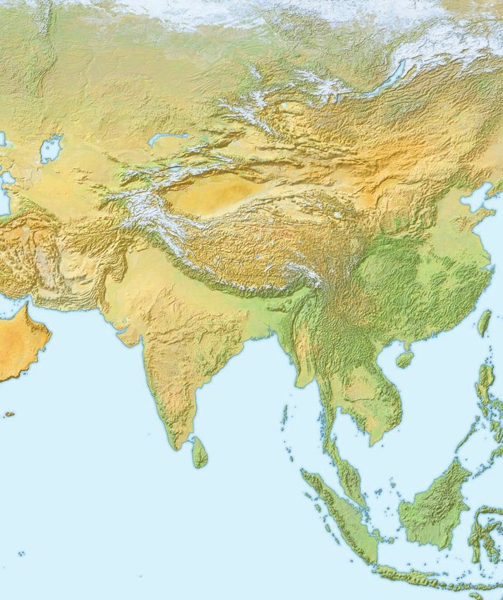
mountains, known as the Alpine-Himalayan chain. [See map literature, law, mathematics, philosophy, medicine, astronomy,
1.] This rocky and convoluted landscape stretches eastward cartography, chemistry, and the calendar.
from the Pyrenees Mountains of northern Spain in a nearly At the risk of oversimplification, the Fertile Crescent may
unbroken 7,000-mile line to the towering Himalayan chain of be divided into two topographic spheres, known respectively
India and Nepal and the Tsinling Shan range of inland China. as “Mesopotamia” and “Levant.” The word “Mesopotamia”
Near the center of this sprawling alpine uplift stand the lofty (a Greek term meaning “[the land] between the rivers”),
Taurus, Pontus, Urartu, and Kurdistan Mountains of Turkey was applied to the eastern sphere as early as the writings
(rising at places to an elevation of nearly 17,000 feet, with peaks of Polybius, Strabo, and Josephus (200 b.c. to a.d. 100).16
snow-clad year round) and the Zagros and Elburz ranges of Earlier still, the translators of the Septuagint (LXX) employed
Iran (a few peaks of which ascend over 18,000 feet, the highest the word to designate the district from which the patriarch
in all the Near East). Whether Akkadian, Egyptian, Assyrian, Abraham had emigrated (Gen. 24:10), rendered by Hebrew
Babylonian, Phoenician, Persian, or Greek, ancient civilization scribes as Aram-naharaim (“Aram of the two rivers”). It is
was never fully able to transcend or penetrate such formidable likely that this Hebrew expression should be understood to
terrain for imperialistic purposes. Indeed, all Near Eastern demarcate only the land between the Euphrates and the Balih
empires prior to the time of Julius Caesar were largely restrained rivers, known also as Paddan-aram (“the field of Aram” [e.g.,
by this northern barrier. Moreover, there always lurked in those Gen. 28:2f; 33:18; 35:9]), and not the entire terrain between
dim and mountainous recesses fierce peoples who periodically the Tigris and Euphrates. [See maps 2 and 30.] Nevertheless,
threatened Semitic domination of the northern frontier. contemporary references to “Mesopotamia” conventionally
Farther south, extending eastward from the Atlantic shores denote the “island” of land bounded on the west and south by
of North Africa, is an enormous expanse of almost waterless the Euphrates, on the east by the Tigris, and on the north by
terrain. Known across that continent as the Sahara Desert, this the outliers of the Taurus and Kurdistan mountains. The low-
barren and desolate environment stretches beyond the Red Sea lying plain of Mesopotamia lies at an altitude of about 1,625
and spans the entire Arabian Peninsula as the Arabian Desert. feet in some northern sectors and slopes gently toward the
The arid zone crosses the mountains of Iran to the north Persian Gulf. [See map 2.]
side and continues through the Salt Desert (Dasht-e Kavir), Variations in precipitation differentiate Mesopotamia into a
Tarim Basin, and into the Gobi Desert of southern Mongolia. wet and dry steppe. The wet steppe receives more than twelve
Broadening at places to more than 1,000 miles in width, and inches of rainfall annually. It is characterized by red-brown
stretching nearly 5,000 miles across two continents, this band sediment, perennial grasses, herbs, and bushes, especially as
of savage, foreboding sand was yet another impassable barrier one moves from west to east. This area between the Euphrates
to imperialism and civilization in antiquity. and the Balih rivers is most closely associated with the biblical
Hemmed in by these two natural barriers of mountain patriarchs and consists of low, stony hills that are bare of
and desert lies a thin, semicircular strip of comparatively vegetation except when watered in the spring. Between the
arable land that arches northward from the southeastern Balih and the Habur rivers, the steppe is less arid and even
corner of the Mediterranean Sea near Gaza (Acts 8:26) relatively fertile in the springtime and early summer. The area
[map 2], through Israel, Lebanon, and western Syria. Near is quite suitable for pasturage, yet survival in this part of the
the northeastern corner of the Mediterranean, this strip steppe depended on the numerous wells scattered throughout
bends eastward and then curves southeastward, essentially the terrain (Gen. 24:11; 29:2). The area does not seem to have
following the flood plains of the Tigris and Euphrates river been heavily occupied or cultivated in antiquity.
valleys as far as the head of the Persian Gulf. Since the days The upper Habur River appears on the map in the shape
of the Egyptologist James Breasted,15 this strip of land has of an inverted triangle where the land flattens considerably.
been known as the “Fertile Crescent.” In this Crescent, Adequate rainfall and good soil has allowed agriculture to
humankind invented the plow, the wheel, the lever and flourish here since high antiquity, producing an abundance of
screw, and the arch. Here they learned how to domesticate the best grain in all of Mesopotamia. Flanking either side of
18 The Moody Atlas of the Bible
01 Chapter layout.indd 18 8/5/09 08:47:56the southern point of this triangle, mountainous outcroppings formations and dunes, a result of sand blowing off the
retain the soil and mineral deposits washed down from Arabian Desert. At the same time, southern Mesopotamia
the north. Accordingly, this region tends to remain grassy has always had to contend with the problem of a higher water
throughout even the summer and autumn months, so it table brought on by over-irrigation, thus producing an ever-
provided lush grazing grounds for Mesopotamian shepherds increasing soil salination. Some authorities, in fact, suggest
who would migrate during the spring and summer from their that the decline of the Sumerian civilization there, and the
native areas south of the Euphrates. The mountains also sustain subsequent shift northward of the cultural centers, can be
essentially all the native timber available in Mesopotamia— attributed to the creeping salination of the soil.17 This is far
pine, oak, terebinth, and pistachio trees. In modern times from certain, though we do know that the Sumerian economy
poplar trees have been planted throughout much of depended heavily on locally grown grain yields, far beyond
Mesopotamia, both as windbreaks and for architectural usage. what could be produced later in antiquity or any time since.18
Most of the dry steppe, by way of contrast, is characterized The region between the confluence of the Tigris and
by gray gypsum desert soils, shallow-rooted seasonal grasses, Euphrates and the Persian Gulf is known as the Shatt el-
scattered shrubs, and—where the soil is deep enough— Arab waterway. Twice daily the water level in this vicinity
marginal dry-farming of winter crops. Below the eight-inch rises and falls by about six feet, a cause of periodic boundary
precipitation line, only limited-scale irrigation farming is disputes between Iraq and Iran. Geographically speaking,
practiced. The flood plain of the middle Euphrates, particularly the fluctuation permits salt water from the Gulf to penetrate
in the area of Deir ez-Zor and south, is as deep as 300 feet and inland, thereby creating a marshy area that severely restricts
up to eight miles wide. The humus soil deposited there by the human settlement.
Euphrates and Habur is ideal for agriculture, and an entire This general overview enables one to realize that the phrase
network of settlements is known to have existed in this region “Fertile Crescent” is quite open to misinterpretation. More
throughout the biblical period. On a much more limited scale, accurately, most of Mesopotamia can be called “fertile” only by
the same conditions exist along a short section of the middle way of contrast with its arid, desert neighbor, and only along
Tigris, in the area around Samarra, where the deposition of
the Tigris and the Lower Zab has created a bed of rich alluvial
sediments. The soil of south Mesopotamia is uniformly hard Both the city of Diyarbekir (on the horizon) and local sheep (right of river) draw their
and nearly impenetrable. The landscape exhibits windblown sustenance from the waters of the upper Tigris river.
The Physical Geography of the Land 19
01 Chapter layout.indd 19 8/5/09 08:47:57You can also read