THE DEVONIAN SEDIMENTARY RECORD OF MONTANA
←
→
Page content transcription
If your browser does not render page correctly, please read the page content below
THE DEVONIAN SEDIMENTARY RECORD OF MONTANA

   Michael H. Hofmann

  Department of Geosciences, University of Montana, Missoula, Montana

                                                  ABSTRACT
    More than a century has passed since Peale established the presence of Devonian rocks in Montana, and
since then, much has been documented about the distribution, facies character, and depositional origin of these
strata. Most attention has been given to the Devonian record in the western part of Montana where rocks are
widespread on the surface. However, this record from outcrop is incomplete, since during the Kaskaskia trans-
gression Montana was first inundated in the northeast in what is now the Williston Basin. There the Devonian
record goes as far back as the Eifelian with basal conglomerates of the Ashern Formation, representing a trans-
gressive lag deposited on the previously exposed craton. In the western half of Montana widespread Devonian
deposition did not occur until the latest Givetian (Maywood Formation) and more prominently during earliest
Frasnian. At this time the Kaskaskia transgression closed in from the present-day east and west, depositing the
Jefferson Dolomite, the thickest Devonian formation in Montana. This deposition did not occur gradually, but
stepwise, resulting in the formation of well-recognized depositional cycles that reflect changes in accommo-
dation on the craton. Accommodation was mainly driven by eustacy during the Eifelian to early Frasnian, but
tectonic controls became more significant by the end of the Devonian as the Antler Orogeny influenced the cra-
tonic margin. This transition from a mainly passive margin setting to an active margin resulted in the formation
of small sub-basins across present-day Montana. These basins were typically bound by deep-rooted lineaments
that were reactivated during the Antler collision. This tectonic inheritance and local deposition is best recorded
in the Famennian to Tournaisian strata, namely the Bakken, Exshaw, and Sappington Formations. This review
summarizes the Devonian strata in Montana and the diverse observations and interpretations as reported by
researchers over more than a century.

                 INTRODUCTION                             a result of the 1970s oil crisis and the interest in the
                                                          hydrocarbon potential of several of the Devonian
    “The following note is written simply to place        strata in Montana. The number of publications stayed
upon record the first positive identification of Devoni- at a relatively high level throughout the next decades,
an strata in the Rocky-Mountain region of Montana.”       but started to drop from this high nevertheless. The
These are the words that A.C. Peale used to describe      recent uptick in peer-reviewed publications shows that
for the first time the occurrence of Devonian rocks in    the Devonian in Montana remains an interval of great
Montana (Peale, 1885). Nearly a century and a half        interest and active geologic research, in no small part
later, hundreds of peer-reviewed articles, theses, and    because of the “unconventional” oil and gas drilling
dissertations, and countless non-peer-reviewed reports, boom that swept across North America a decade ago,
abstracts, and presentations have been published that     elevating the Williston Basin (fig. 2) in northeastern
describe the Devonian strata in Montana at the surface Montana and adjacent states and Canadian provinc-
and in the subsurface (fig. 1). The number of Devonian es to one of the top three oil-producing basins in the
publications in the State vary greatly and are often re- continental United States (Gaswirth and others, 2013;
lated to developments in the energy industry. Up until    Gaswirth and Marra, 2015).
the 1950s, publications about the Devonian in Mon-
tana were rare. A first uptick in publications is notable     The "Bakken Boom," named after the main hydro-
in the 1960s and 1970s, not to a small degree driven      carbon-bearing latest Devonian Bakken Formation,
by the USGS and the work done by Sandberg and oth- not only sparked an increase in geologic work in the
ers. A flourish of publications followed in the 1980s,    subsurface in northeastern Montana and adjacent

                                                                                                                     1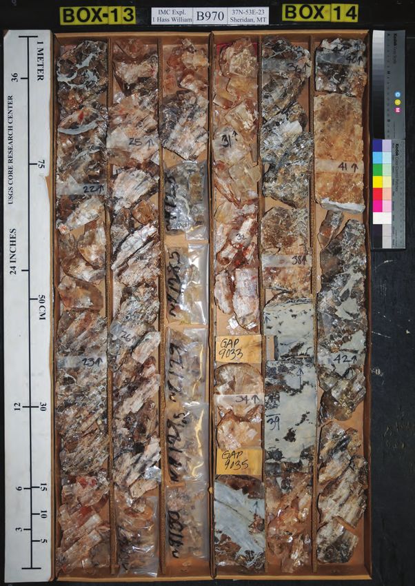
Figure 1
  MBMG Special Publication 122: Geology of Montana, vol. 1: Geologic History

                                        12                                                                        50
                                                Between 1880-                         Between 1980-1989,
                                                1889, ~11% of                            46 peer reviewed
                                                                                                                  45

                                                                                                                       Number of Publications
                                        10

                      Montana Geosciences
                                                all MT geo                                 publications on        40
                                                publications                          ‘Devonian+Montana’

                        Percent of Total
                                                included                                                          35

                          Publications
                                            8
                                                ‘Devonian’                                                        30
                                            6                                                                     25
                                                                                                                  20
                                            4
                                                                                                                  15
                                                                                                                  10
                                            2
                                                                                                                  5
                                            0                                                                     0
                                               59 69 79 89 99 09 19 29 39 49 59 69 79 89 99 09 19
                                           - 18 -18 -18 -18 -18 -19 -19 -19 -19 -19 -19 -19 -19 -19 -19 -20 -20
                                         50 60 70 80 90 00 10 20 30 40 50 60 70 80 90 00 10
Figure 2                               18 18 18 18 18 19 19 19 19 19 19 19 19 19 19 20 20

                                                                             Publication Year
                                                           Devonian peer reviewed %   Devonian AND Montana
  Figure 1. Bar graph showing the number of peer-reviewed publications written about the Devonian in Montana in absolute numbers
  per decade (red bars) and in percent of all geologic publications published on Montana geology per decade (blue bars). A total of 200
  peer-reviewed publications are listed on GeoRef that are concerned with the Devonian in Montana or mention Devonian in Montana
  (GeoRef search on ‘Devonian AND Montana’ on July 27th, 2020).

  Figure 2. Location map of figures (markers) and locations (italic labels) referred to in this report. Background map is a colored, shaded
  relief map of Montana, with cooler colors depicting higher elevations.

  2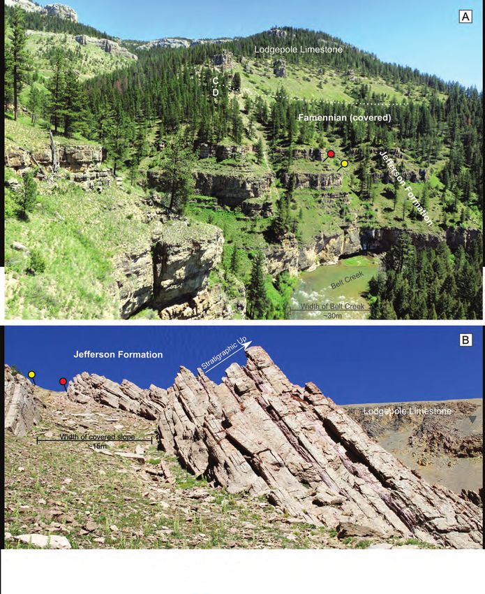
Michael H. Hofmann: Devonian Sedimentary Record of Montana

 states and provinces (e.g., Sonnenberg and others,                    of the Devonian in Montana, while also challenging
 2017; Hogancamp and Pocknall, 2018; Petty, 2019;                      certain assumptions about statewide synchronicity
 Hart and Hofmann, 2020), but it also drove a flur-                    of events, paleogeography, and controls on sedimen-
 ry of studies in the central and western part of the                  tation (e.g., Johnson and Sandberg, 1988; Dorobek,
 State (e.g., Myrow and others, 2015; Rodriguez and                    1991; Gantyno, 2010; Grader and others, 2014, 2016;
 others, 2016; diPasquo and others, 2017; Phelps and                   Cole and others, 2015; Myrow and others, 2015; di
 others, 2018; Hohman and others, 2019; diPasquo                       Pasquo and others, 2017, 2019; Phelps and others,
 and others, 2019; Browne and others, 2020; Schultz                    2018; Hogancamp and Pocknall, 2018; Hohman and
 and Hofmann, 2021). There, Devonian strata are well                   others, 2019; Hart and Hofmann, 2020; Browne and
 exposed (figs. 2, 3) and are used as an analog to help                others, 2020; Ronemus and others, 2020). This review
 better understand the stratigraphic architecture and fa-              is an attempt to summarize over a century of excellent
 cies distribution that control the production of oil and              Devonian geologic research in Montana with an eye
 gas in the subsurface.                                                on the large-scale controlling factors, namely eustacy
     In the past couple of decades, sequence strati-                   and tectonics.
 graphic analyses and other modern analytical tech-
 niques3 produced a more complex stratigraphic picture
Figure

                                   Devonian (~250m)
            Middle                          Upper
                                                                            DMs
                                                                  Dt                                   Mm
                                          Dj               Djb
                                                                            Dtt
                                                                    Dtl

               Dm

      Ꞓsr

 Figure 3. The Devonian strata in the northern Bridger Range in SW Montana as viewed from Sacagawea Peak looking to the northwest.
 The entire Devonian section is approximately 250 m (820 ft) thick at this location. The oldest Devonian rocks are the Givetian to Fras-
 nian Maywood Formation (Dm) disconformably overlying the Cambrian Snowy Range Formation (Ꞓsr). The Maywood Formation at this
 location is as much as 27 m thick and primarily composed of reddish orange to pale yellow gray, thin-bedded siltstones and mudstones
 (Skipp and others, 1999). The mainly light to dark brown and gray, medium- to thick-bedded dolostones and dolomitic limestones of
 the Jefferson Formation (Dj) are prominently exposed in the center of the photograph. An increase in pale yellow and tan limestones
 and dolomitic siltstones near the top of the Jefferson is part of the Birdbear Member (Nisku; Djb). Some small folds and faults (orange
 dotted-dashed lines) are visible in the Jefferson. The entire Three Forks Formation (Dt) is ~50 m thick and exposed in the saddle just
 to the left (southwest) of the peak. The lower Logan Gulch member (Dtl) conformably overlies the Jefferson Formation. The orange and
 tan, limonitic shales are topped by a ledge-forming limestone and dissolution breccia with variable thickness (collapse structures) and
 are visible near the saddle and peeking through the talus slope. The olive to green and gray mudstones of the Trident Member (Dtt)
 are separated from the Sappington Formation (DMs) by another unconformity. Thin limestone beds of the Lodgepole Formation of the
 Mississippian Madison Group (Mm) are well exposed towards the top of the section. The black dotted rectangle is the location of fig. 18;
 the gray triangle refers to the same location in fig. 15B. Source of photo: author.
                                                                                                                                        3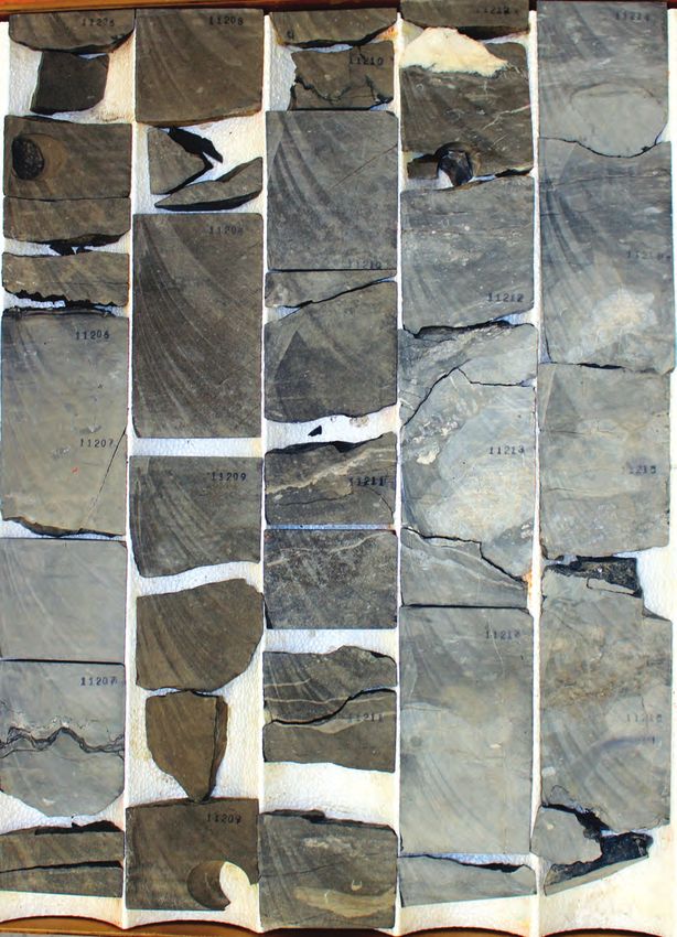
MBMG Special Publication 122: Geology of Montana, vol. 1: Geologic History

  1.1 From Lithostratigraphy to Chronostratigraphy to                 during the Devonian (Woodward, 1996), limited the
 Sequence Stratigraphy—The Kaskaskia Megasequence                     correlation of stratigraphic intervals across the State
     The first geologic examination of Devonian strata                and resulted in the establishment of local stratigraph-
 in Montana was undertaken in the Three Forks area,                   ic names early on. Most infamous in this regard are
 northwest of Bozeman (fig. 2), in southwest Montana                  the latest Famennian to earliest Tournaisian Bakken/
 in 1860, by F.V. Hayden as a member of the United                    Exshaw/Sappington Formation (figs. 3, 5). In the
 States Army mapping expedition let by William F.                     Milligan Canyon type section, west of Three Forks,
 Raynolds. Subsequent visits to the Three Forks area                  Berry (1943) assigned the name Sappington Sand-
 by A.C. Peale and other members of the USGS in                       stone to ~18 m (60 ft) of yellow sandstone above the
 1871, 1872, and 1884 provided the groundwork for                     Three Forks Shale. Ten years later, Nordquist (1953)
 the first geologic map of the area and the mention of                recognized a similar lithologic succession overlying
 Devonian strata in the State (fig. 4), namely the Upper              the Three Forks Formation in the Williston Basin and
 Devonian Jefferson Formation and the Three Forks                     named it the Bakken Formation. Another decade later,
 Shale (Peale, 1893). The occurrence of brachiopods                   the Exshaw Shale, a black shale, sandstone, and car-
 and stromatoporoids in the Three Forks and Jefferson                 bonate unit in Canada (Warren, 1937), was formally
 Formations was recognized early on and was critical                  described as extending from Canada into northwest
 for correlating Devonian strata into other parts of the              Montana (Sandberg, 1966). This tripartite nomencla-
 State (e.g., Raymond, 1907, 1909; Haynes, 1916;                      ture for the latest Famennian and earliest Tournaisian
 Deiss, 1933, 1936, 1943; Berry, 1943; Sloss and Laird,               strata is still used today, and all three names are rec-
 1946, 1947).                                                         ognized with formation status in Montana and used in
                                                                      the regions of their initial use.
     A general pinch-out of Devonian strata onto the
 Central
Figure  4 Montana Uplift, an area of structural inversion

 Figure 4. Copy of Peale’s original 1893 geological map of the Three Forks area. Devonian stratigraphy was mapped for the first time in
 Montana. The sketch and photograph shown in figure 12 were taken at the present site of Logan, Montana (arrow). See also fig. 2 for
 location.
 4
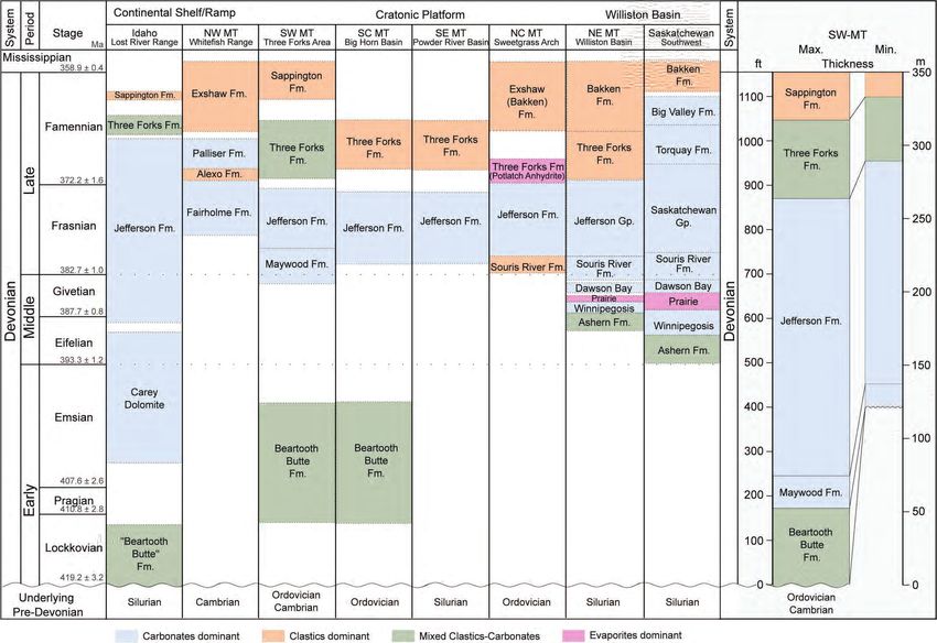
Figure 5. Chronostratigraphic correlation chart of Devonian strata (formation and group level) in Montana and adjacent areas. The most complete Devonian section in Montana is
    preserved in the Williston Basin (NE MT). Devonian strata generally thin towards central Montana onto the Devonian cratonic platform, then thicken to the west and into Idaho—the
    Devonian continental margin. The dominant facies throughout Montana are carbonates (blue), but clastics and mixed facies are present during the onset of Devonian deposition as
    well as during the waning stages. The carbonate facies dominance is best recognized when displaying the Devonian on a thickness scale (the two sections to the right with a light
    gray background), rather than on the time stratigraphic chart. Chart compiled with data from McMannis (1955), Sandberg (1961a, 1962a, 1965), Sandberg and Mapel (1967), Sand-
    berg and McMannis (1964), Meyers (1971), Mallory and Hennerman (1972), Sandberg and Poole (1977), Balster (1980), Johnson and others (1985), Ehrets and Kissling (1987),
    Maughan (1989), Seward and Dyman (1990), Seward (1990), Grader and Dehler (1999), Stearns (2001), Schietinger (2013), Saskatchewan Ministry of the Economy (2014), Grader
    and others (2014, 2016), Rodriguez and others (2016), diPasco and others (2017), Hogancamp and Pocknall (2018).
                                                                                                                                                                                        Michael H. Hofmann: Devonian Sedimentary Record of Montana

5
MBMG Special Publication 122: Geology of Montana, vol. 1: Geologic History

Figure 6. Compilation chart of global and local Devonian events and stratigraphy. From left to right, the tracks are chronostratigraphic
scale (age) in million years (Ma), from Becker and others (2016) and Brett and others (2020); epoch and age boundaries scaled to
chronostratigraphic scale; conodont zones (old and new) scaled to chronostratigraphic scale, from Becker and others (2016); bioevents
(1st order bioevents in bold text, 2nd order in regular text, 3rd and higher order in gray text), modified from Becker and others (2016),
and Brett and others (2020); low-latitude sea surface temperature in °C (SST; red solid line) and carbon isotope data in permill (δ13C;
black dashed line), modified from Buggisch and Joachimski (2006) and Joachimski and others (2009); major tectonic events (global and
relevant to Montana, double arrows and color bars) based on data from Dorobek and others (1991), and McKerrow and others (2000);
Devonian glaciation events in Gondwana and Laurentia (blue boxes) reported in Streel and others (2000), Caputo and others (2008),
(Caption continued on next page)

6
Michael H. Hofmann: Devonian Sedimentary Record of Montana

Isaacson and others (2008); qualitative eustatic sea level, 1 from Haq and Schutter (2008), and 2 from Johnson and others (1985); T-R
cycles (Johnson and others, 1985) and Supersequences (Haq and Schutter, 2008) scaled to the chronostratigraphic scale; stratigraph-
ic column, including dominant lithology and major unconformities, for southwest Montana (fig. 2 for location) and northeast Montana,
scaled to the chronostratigraphic scale (vertical scale), and depositional environment (horizontal scale). Montana stratigraphic columns
compiled with data from McMannis (1955), Sandberg (1965), Sandberg and McMannis (1964), Sandberg and Mapel (1967), Meyers
(1971), Mallory and Hennerman (1972), Sandberg and Poole (1977), Ehrets and Kissling (1987), Stearns (2001), Grader and others
(2014, 2016), Rodriguez and others (2016), di Pasco and others (2017), Hogancamp and Pocknall (2018).

                                                                                                                                           7
MBMG Special Publication 122: Geology of Montana, vol. 1: Geologic History

    The recognition of cratonal correlative megase-                 STRATIGRAPHY, FACIES, AND
quences (Sloss, 1963) followed by the development of                   FACIES DISTRIBUTION
seismic and sequence stratigraphic principles (Payton,
1977; Vail and others, 1977; Vail, 1987) revolutionized                    Early and Middle Devonian
how the stratigraphic record is analyzed. The subdivi-           The oldest Devonian deposits preserved in Mon-
sion of lithologic successions into related depositional    tana belong to the Beartooth Butte Formation (figs.
sequences, bound by unconformities and other signif-        5–7), a heterolithic accumulation of thin-bedded red
icant surfaces, provides a useful tool for analyzing ge-    and buff mudstone, gray to yellowish carbonate mud-
netically and chronologically related stratigraphy and      stone, sandstone, sandy and silty dolomite, limestone
facies distributions in an area. The Devonian in Mon-       conglomerate and breccia, and light gray to grayish
tana is no exception, because the base of the Devonian      red dolomite containing fish and plant fossil remains
is marked by a regional unconformity, the basal Devo-       (Dorf, 1934; Sandberg, 1961a; Sandberg and Mapel,
nian unconformity, that is onlapped by the time-trans-      1967; Meyers, 1971; Fiorillo, 2000). In outcrop the
gressive strata of the Kaskaskia Megasequence, the          formation is only found locally in southwestern,
third oldest of the six cratonic megasequences recog-       south-central, and central Montana, as far north as
nized in North America (fig. 6, previous pages; Sloss       the Big Snowy Mountains (fig. 2). Where it occurs,
and Laird, 1947; Sloss, 1950, 1963; Sandberg and            its thickness varies over short distances but can be as
others, 1988). The Devonian rocks in western Mon-           much as 52 m (170 ft; fig. 7; Sandberg, 1961a; Sand-
tana overlie Cambrian strata, in central Montana the        berg and Mapel, 1967; Meyers, 1971).
Devonian strata is in contact with Ordovician rocks              The North American continent remained largely
below the unconformity, and in the northeastern part        exposed during the Middle Devonian, and deposition
of the State, Silurian strata is truncated by the basal     was limited to isolated basins (fig. 8A). The same is
Devonian unconformity (fig. 5).                             true in Montana, where the onset of more widespread
    In general, the Kaskaskia Megasequence in Mon-          deposition started in the Middle Devonian, although
tana can be separated into two distinct higher order        first only in eastern Montana (fig. 8B). There, the on-
supersequences. The lower Kaskaskia (Kaskaskia I)           set of Kaskaskia transgression is marked by the silici-
Supersequence (fig. 6) is of mid-Early Devonian to          clastic and mixed carbonate siliciclastic units of the
latest Devonian (Pragian–Famennian) age, and the up-        Ashern Formation (figs. 5, 6; Baillie, 1951). The thin
per Kaskaskia (Kasakskia II) Supersequence is latest        Ashern Formation was included as part of the Winni-
Devonian (Famennian) to late Mississippian (Visean/         pegosis Formation (Sandberg and Hammond, 1958),
Serpukhovian; Haq and Schutter, 2008). Carbonate            but others recognized it as the basal formation of the
rocks are the dominant lithology (by thickness) in the      Elk Point Group (McGehee, 1949; Belyea, 1952;
Kaskaskia Megasequence rock record in Montana,              Baillie, 1953, 1955; Sandberg, 1961b; Lobdell, 1984).
but evaporites and siliciclastic deposits also occur to a   Breccias in the lower parts (lower member after Lob-
lesser degree, the latter in particular during the onset    dell, 1984) of the Ashern Formation are interpreted as
and waning stages of deposition of Devonian strata          transgressive lags and contain abundant reworked Sil-
(figs. 5, 6). This Devonian review largely focuses on       urian subcrop strata. Claystone, silty and argillaceous
the deposits of the Kaskaskia I Supersequence and           dolomite, dolomitic shale, and dolomitic limestone are
the early stages of the Kaskaskia II Supersequence          common facies; evaporites occur locally in the lower
(Famennian) that are described in ascending temporal        Ashern Formation, whereas cephalopods, gastropods,
order, starting from the oldest Devonian rocks that are     and brachiopods are more common near the top of the
recognized only locally in western Montana, to the          formation. In general, lithologies in the lower Ashern
youngest formations that bridge the Devonian to Mis-        Formation have a more intense red color and change
sissippian boundary throughout Montana.                     to a greener hue higher up in the succession (Baillie,
                                                            1953; Lewis, 1958; Lobdell, 1984; Rosenthal, 1987;
                                                            Megathan, 1987).
                                                                 Overlying the mixed clastic-carbonate facies of the
                                                            Ashern Formation are mainly limestone beds of the
                                                            Winnipegosis Formation (figs. 5, 6; Tyrrell, 1892).

8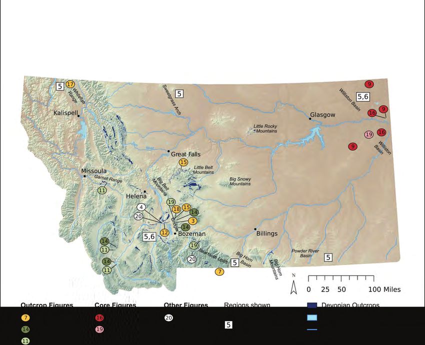
A
Dj
Ob
B C D
Dj
Dm?
Db
Ob
Figure 7. The Beartooth Butte Formation at its type locality at Beartooth Butte, WY, in the Beartooth Mountains, just ~3.5 mi south of the Montana border (see fig. 2 for location). (A)
Beartooth Butte viewed from “Top of the World” on Beartooth Highway (Hwy 212). The intensely red Beartooth Butte Formation is infilling channel-like incisions carved into the un-
derlying, largely gray Ordovician Big Horn Dolomite (Ob; Sandberg, 1961a). Subsequently, the Beartooth Butte Formation was overlain by the nearly horizontal beds of the younger
Devonian strata. Most recognizable are the beds of the Frasnian Jefferson Formation (Dj). View is due west; height of outcrop is ~800 ft. Thickness of Beartooth Butte Formation is
approximately 150 ft (50 m; Fiorillo, 2000). Close-up photograph (B) and line drawing (C) of the Beartooth Butte Formation from Beartooth Lake (view is due NW; see white dashed
outline in A for approximate photo area). Conglomerates (triangles in C) form the basal facies of the Beartooth Butte Formation. The thin-bedded red mudstones onlap the basal
conglomerates. The inclined beds gradually flatten upward. Horizontal, tan to yellowish, very thin beds can be seen atop the red Beartooth Butte thin beds and might be deposits of
the Maywood Formation (Dm). The medium-bedded, medium gray beds above are the dolomite facies of the Frasnian Jefferson Formation (Dj). (D) Plot of stable oxygen and car-
bon isotope data from Beartooth Butte Formation localities in Montana and Wyoming, showing the increase in freshwater influence from the Beartooth Butte type locality towards
Michael H. Hofmann: Devonian Sedimentary Record of Montana
the north into central Montana (Half Moon samples; figure from Fiorillo, 2000). Source of photos: author.
9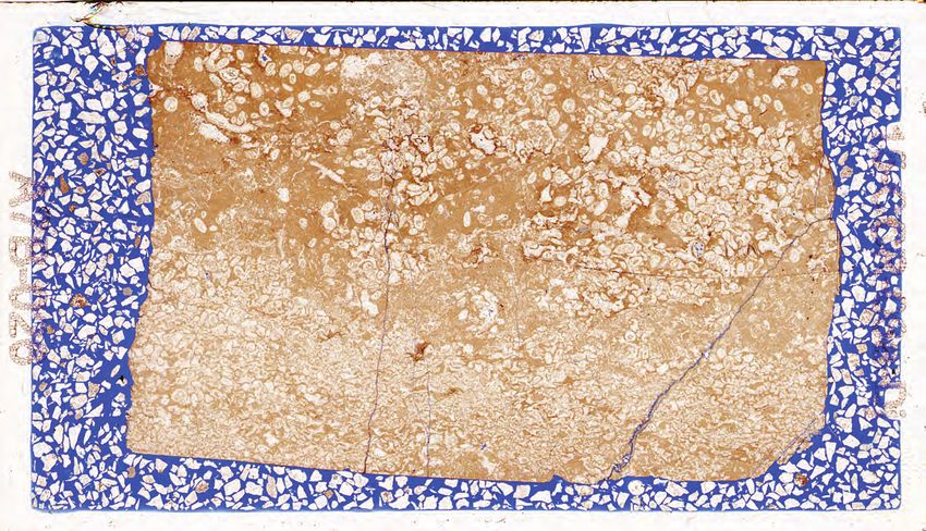
Figure 8
MBMG Special Publication 122: Geology of Montana, vol. 1: Geologic History

     Middle Devonian
     Oce alassa
          h                                    Baltica
        an
     Pant

                                   Laurentia
                      El
                        kP
                          oi
                            nt
                     Montana
                               Ba
                                  sin

                                                              n
                                                            ea
                                                                                                     Montana

                                                         Oc
                                                   eic
                                                 Rh
      A                                                           B
Figure 8. Middle Devonian paleogeography. Baltica and Laurentia were almost fully exposed during this time and the Kaskaskia trans-
gression only inundated isolated areas, including the Elk Point Basin in northeast Montana (A). Early Middle Devonian rocks (Eifelian)
are only found in the subsurface in northeastern Montana, including the Ashern, Winnipegosis, Prairie, and Dawson Bay Formations (B).
During the late Middle Devonian (Givetian), continued flooding of the craton from the west and the east resulted in more widespread
deposition of the Maywood and Souris River Formations (see also fig. 10). Basement lineaments (gray dashed lines) might have had
some control on the paleogeography, but a clear trend is not obvious during this time in part because of the limited exposures of these
deposits. DSZ, Dillon Shear Zone; GFSZ, Great Falls Shear Zone; LCL, Lewis and Clark line; MTL, Mesoproterozoic Montana–Tennes-
see line; PL, Perry line; THO, Trans-Hudson orogen; TMFTB, Trans-Montana fold-and-thrust belt. Maps compiled and modified from
Blakey (2016), and Sims and others (2004).

The thickness of the Winnipegosis Formation in the                    conformable by some, but unconformable by others
Williston Basin ranges from 0 to 122 m (0 to 400 ft;                  (e.g., Sandberg and Mapel, 1967; Ehrets and Kissling,
Baillie, 1953, 1955; Sandberg, 1961b), and the unit                   1987)—and is composed of fine-grained siliciclastic
is mainly composed of dolomitic shale, dark gray                      rocks, argillaceous limestone and dolomite, and
calcareous shale and siltstone, argillaceous dolomite,                gray red silty argillaceous dolomite (Baillie, 1953;
light gray to brownish gray dolomite, and fossilifer-                 Sandberg and Hammond, 1958). These mostly
ous limestone (fig. 9; Sandberg and Hammond, 1958;                    siliciclastic basal deposits are succeeded by massive
Sandberg, 1961b; Perrin, 1982, 1987; Ehrets and                       dolomitic limestone and limestone with corals and
Kissling, 1987).                                                      stromatoporoids, and local anhydrite and anhydritic
     The youngest formation of the Elk Point Group                    dolostone in the upper parts (fig. 9; Baillie, 1953;
is the Prairie Formation (figs. 5, 6). In Montana, the                Sandberg and Hammond, 1958). Anhydrite can fill
Prairie Formation only occurs in the subsurface in the                small vugs in brecciated limestones and dolostones,
far northeastern corner of the State, mainly in Sher-                 together with calcite (fig. 9).
idan County, where it thickens to over 61 m (200 ft;                       In contrast to the majority of the Middle Devonian
Nicolas, 2015), consisting of mainly halite (fig. 9),                 strata that are largely only present in the subsurface
with lesser sylvite, potash, anhydrite, dolomite, clay,               in northeastern Montana, Late Devonian strata are
and quartz (Berg, 2010). The facies changes laterally,                widespread across the State (fig. 5). The first deposits
including interbedded anhydritic dolostones, dolomitic                of very late Middle Devonian (late Givetian) to ear-
mudstone, and siltstone with halite inclusions, and can               ly Late Devonian (early Frasnian) age are the Souris
reach a thickness of 183 m (600 ft) in the central parts              River Formation (figs. 5, 6)—present in the subsurface
of the Williston Basin in North Dakota and Saskatch-                  in eastern Montana (including the Williston Basin), in
ewan (Sandberg and Hammond, 1958; Bannatyne,                          the central Montana uplift, the Sweetgrass Arch, and
1983; LeFever and Le Fever, 2005; Nicolas, 2015).                     in the Big Horn Basin of south-central Montana—and
     Overlying the Elk Point Group is the Dawson                      the time-equivalent Maywood Formation in western
Bay Formation (figs. 5, 6). Like the Elk Point Group,                 and southwestern Montana (late Givetian to early
the Dawson Bay Formation is only described in the                     Frasnian; Sandberg, 1962a, 1967; Kauffman and Earll,
subsurface in northeastern Montana. The Dawson Bay                    1963; Mayers, 1971).
Formation overlies the Prairie Formation—the basal                        The thickness of the Maywood and Souris Forma-
contact of the Dawson Bay Formation is described as                   tions varies greatly (McMannis, 1962; Sandberg and
10
Michael H. Hofmann: Devonian Sedimentary Record of Montana
Winnipegosis Formation
A
ᶲ = 10.6%, k = 0.8md
ᶲ = 10.2%, k = 6.3md
ᶲ = 7.9%, k = 1.7md
ᶲ = 8.5%, k = 1.1md
dolomite
limestone
dolomite
dolomitic
mudstone
ᶲ = 10.4%, k = 1.03md
ᶲ = 0.2%, k = 0.03md
ᶲ = 9.1%, k = 0.9md
ᶲ = 0.8%, k = 1.1md
dolomite
limestone
Stylolite
dolomite
Figure 9A. Middle and early Late Devonian facies in core. This example from the western Williston Basin (Roosevelt County) shows the
heterolithic Winnipegosis facies compressed in one core box with Helium porosity and maximum air permeability listed alongside. Main-
ly dark gray and brownish gray sucrosic dolomite (above red line) and thin interbeds of dolomitic mudstone (at 11,207 ft marker). Apart
from the mudstone interval, the porosity of the dolomites is consistently at approximately 10%, although permeability varies from 6 md. A centimeter-scale amplitude stylolite at the base of the mudstone interval provides evidence for abundant pressure solution.
Below the dashed red line, well-cemented (low porosity and permeability), brecciated, and fossiliferous limestones are the dominant
facies. Photo from core Granley State 4-15X (API#: 2508521604), Roosevelt County, MT. Core box height is 2 ft. Photo source: author.
11Figure
MBMG Special 9 continued
Publication 122: Geology of Montana, vol. 1: Geologic History
B Prairie Formation Dawson Bay Formation
salt
salt
mudstone mudstone brecciated
clasts limestone fossilferous
limestone
salt
clasts
mudstone
Figure 9B. Middle and early Late Devonian facies in core. The Prairie Formation (left) contains abundant salt deposits interbedded with
intervals of mudstones. Photo from core W.H. Hass #1 (API#: 2509121328), Sheridan County, Montana. Core box height is 3 ft. Photo
source: USGS, https://my.usgs.gov/crcwc/. This example of mainly calcareous and dolomitic facies of the Dawson Bay Formation (right)
is from Dawson County, Montana. Photo from core Burlington Northern 1 (API#: 2502121041), Dawson County, Montana. Core box
height is 3 ft. Photo source: USGS, https://my.usgs.gov/crcwc/.
12Michael H. Hofmann: Devonian Sedimentary Record of Montana
McMannis, 1964; Grant, 1965; Meyers, 1971, 1980; Thomas, 2011). More common are tan, brown, yellow,
Thomas, 2011), but generally increases from central red, greenish gray, and green, thin-bedded to laminat-
Montana to the west towards the Devonian shelf mar- ed, finely crystalline limestone, dolomitic limestone,
gin and northeast into the Williston Basin (figs. 5, 10; microcrystalline and finely crystalline dolostone,
e.g., Emmons and Calkins, 1913; Sandberg, 1962a; silty dolostone, argillaceous dolostone, dolomitic
Kauffman and Earll, 1963; Carlson and Anderson, mudstone, and thin beds or laminae of siltstone, silici-
1965; Witkind, 1971; Mudge, 1972; Mudge and oth- clastic mudstone, and calcareous shale (Emmons and
ers, 1982; Porter and Wilde, 2001), with the greatest Calkins 1913; Meyers, 1971; Witkind, 1971; Mudge,
thickness of about 120 m (394 ft) reported from north- 1972; Porter and Wilde, 2001; Vuke and others, 2014;
west Montana (Vuke and others, 2007). In central and Thomas, 2011). Siliciclastic interbeds (figs. 11A–11C)
southern Montana, the Maywood and Souris River are most common in central Montana (Witkind, 1971),
Formations are absent; however, the position of this and also generally increase towards the north (fig. 10)
pinch-out is not very well constrained. Figure 10 high- and northeast (Sandberg and Hammond, 1958; Sand-
lights the area of uncertainty for the zero edge of the berg, 1961b; Carlson and Anderson, 1965; Porter and
Maywood/Souris River Formations and also illustrates Wilde, 2001). Anhydrite beds are only present in the
the ongoing transgression of the Kaskaskia seas onto Souris River Formation in eastern Montana (fig. 6;
the craton (compare to paleogeography in fig. 8). Sandberg and Hammond, 1958; Sandberg, 1961b).
The facies of the early Middle Devonian strata are Late Devonian
heterolithic. In some areas in western and eastern cen-
Where present, the Maywood and Souris River
tral Montana, the basal facies are thin conglomerates
Formations are conformably overlain by the Jefferson
Figure(Sandberg
10 and Hammond, 1958; Sandberg, 1961b;
Inc >100
m
rea m
m
00
sin
ne
00
1
gT Z
Zo mFigure
MBMG11Special Publication 122: Geology of Montana, vol. 1: Geologic History
0.5cm
A B
0.5cm
C D
0.5cm
E F
Figure 11. Facies examples of the Maywood Formation (A–C) and the Jefferson Formation (D–L) from Mulkey Gulch in west-central
Montana and of the Jefferson Formation from the southern Pioneer Mountains (G–H) and from Clark Canyon Reservoir (I–L) in south-
west Montana (see fig. 2 for location). Thin section scan (A) and cross-polarized light photomicrograph (B) of fine- to medium-grained
quartzarenite in the Maywood Formation. The well-rounded grains have widespread quartz overgrowth (B, C), and euhedral dolomites
fill some intergranular pores and replace grains locally (C). The Jefferson Formation contains mottled, finely crystalline dolomite, with
(continued on next page)
14Figure 11 cont.
Michael H. Hofmann: Devonian Sedimentary Record of Montana
0.5cm
G H
0.5cm
I J
0.5cm
K L
large vugs (D). Some vugs are calcite cemented (white); others remain open (blue). Some of the dolomites are heavily fractured (E).
Fractures are commonly calcite cemented (white). Calcite is also present as patchy cement in intercrystalline pores; however, porosity
is well preserved between the finely crystalline dolomite crystals (F). Stylolites are evidence for pressure solution after dolomitization (G,
H). Breccias (I, J) and patchy dolomitization of calcareous, fossiliferous limestones (K, L) are common in the Jefferson. Photo source:
author.
15MBMG Special Publication 122: Geology of Montana, vol. 1: Geologic History
Group [including the Duperow and Birdbear (Ni- units varies significantly locally and across the State,
sku) Formations] in eastern Montana, the Jefferson with the thinnest strata [518 m (1,700 ft) thick in the Garnet Range
assigned to fossiliferous, brown and black crystalline in western Montana (Kauffman and Earll, 1963) and
limestones near the town of Three Forks, but an of- continues to thicken into Idaho (fig. 5), and the Jeffer-
ficial type section was not established (Peale, 1893). son Group is as much as 221 m (725 ft) thick in the
Subsequently, the Jefferson type section (fig. 12) was Williston Basin in northeastern Montana (Sandberg
established north of the Gallatin River, across the river and Hammond, 1958).
from Logan, Montana (Sloss and Laird, 1946, 1947; The Jefferson Formation/Group and time-equiva-
Sandberg, 1962a), where the Jefferson Formation has lent strata (fig. 5) contain a richly diverse fauna (Coo-
a total thickness of ~165 m (540 ft; Sandberg, 1965). per and others, 1942; Berry, 1943; Sloss and Laird,
Figure 12
The thickness of these time-equivalent stratigraphic
Dj
Dm
Mm
€rl €pi
€pa
DMs Dt
Figure 12. The Devonian type section near Logan, Montana. Peale’s original sketch (A) of the Devonian outcrops north of the Gallatin
River and a photograph (B) of the same outcrops north of Logan, MT. The Three Forks Limestones from Peale’s 1893 paper include
Cambrian Park Shale (€pa), Pilgrim Limestone (€pi), Red Lion Sandstone (€rl), Devonian [Maywood (Dm)], and Jefferson (Dj) strata.
The Three Forks Shale (in "Devonian Ravine") of Peale are equivalent to the Three Forks Formation (Dt) and the Sappington Formation
(Ds), respectively. The Bridger Limestones are equivalent to the limestones of the Mississippian Madison Group (Mm). For location see
figs. 2, 4. Photo B source: author.
16Michael H. Hofmann: Devonian Sedimentary Record of Montana
Z
Z
FS
DS
B
G
FT
TM
Thickness
LC Basement
[ft] [m]
L Lineaments
1700 500
Measured
Sections 1500
400
1000 300
PL
MTL N
200
500
100
0 50 100
0 0
km
Figure 13. Map of Jefferson thickness (ft) from outcrop measurements in southwest and central Montana. The Jefferson Formation
generally thickens to the west (dark gray areas) and is thinnest to the southwest and towards central Montana (light gray areas). The
thinnest Jefferson thickness, located in SW Montana, is bound by Paleoproterozoic Sutures (gray dashed lines), namely the Trans-Mon-
tana fold and thrust belt (TMFTB) to the southeast and the Dillon Shear Zone (DSZ) to the northwest. Other notable thickness chang-
es occur just northeast of the Lewis and Clark Line (LCL) and northwest of the Great Falls Shear Zone (GFSZ). Jefferson thickness
data (squares) from Deiss (1933), Sloss and Moritz (1951), McMannis (1955), Richards (1955), Klepper and others (1957), Sandberg
(1961b), Kauffman and Earl (1963), Knopf (1963), Robinson and Barnett (1963), McMannis and Chadwick (1964), Sandberg (1965),
Benson (1966), Witkind (1971), Mudge (1972), Lindsey (1980), Kellogg (1992), Porter and others (1996), Skipp and others (1999), Lo-
pez (2000), Porter and Wilde (2001), Vuke and others (2002), Thomas (2011), Stickney and Vuke (2017), and Lund (2018). Basement
structural lineaments from Sims and others (2004).
1947; Nave, 1952; Berg, 1959; McMannis, 1962; Rob- um crystalline to coarsely crystalline, highly porous,
inson and Barnett, 1963; McMannis and Chadwick, granular-weathering, fetid, and intercalated yellow and
1964; Campbell, 1966; Seward, 1990; Dorobek, 1991; pale pink (Berry, 1943; Sloss and Moritz, 1951; Mc-
Pratt, 1998; Thomas, 2011; Grader and others, 2014). Mannis, 1955; Klepper and others, 1957; McMannis,
Stromatoporoids are some of the most distinctive 1962; Knopf, 1963; Sandberg, 1965; Mudge, 1972;
and common fossils in the Jefferson Formation (figs. Kellogg, 1992; Stickney and Vuke, 2017). These are
14A–14E) and some genera, Amphipora and Stro- all used to describe the mainly dolomite facies in the
matopora in particular, can form meter-size, low-relief Jefferson, and dolostone, sandy dolomite, dolomitic
build ups locally. Other fossils in the Jefferson Forma- limestone, limestone, carbonate algal buildups, car-
tion include corals (e.g., Macgeea sp.), bryozoans, bi- bonate breccias, and argillaceous limestone that are
valves (e.g., Grammysia, Paleoneilo), fish fragments, present locally (figs. 11, 14).
ostracodes, calcispheres, crinoids, calcareous algae, A similarly diverse set of adjectives was used
stromatolites (thrombolites), brachiopods, and cono- when describing the lithology in northwest and cen-
donts (fig. 11). The latter two are of great significance tral Montana (figs. 11, 15). There, the dolomite of this
for biostratigraphy of the Frasnian and Famennian in interval, with limestone, lime mudstone, and wacke-
Montana and will be revisited later in this report. stones and packstones present locally, is described as
Mimicking its diverse fossil assemblage, the facies light gray, gray, dark gray (weathers chocolate brown),
of the Jefferson Formation in western and southwest- very dark gray, thin-bedded, medium-bedded, locally
ern Montana are described by a diverse set of adjec- massive, finely crystalline, moderately to coarsely
tives, including thin- to thick-bedded (fig. 15), black, crystalline, with fetid odor locally, seams of black
brown, dark gray and light gray, petroliferous, medi- chert, nodules of algae and cup corals, some anhydrite
17MBMG Special Publication 122: Geology of Montana, vol. 1: Geologic History
Figure 14
A B
C D
E F
G H
Figure 14. Photographs of typical Frasnian and Famennian facies in outcrop from the Jefferson Formation (A–E) and the Sappington
Formation (F–H). Mottled, fossiliferous (stromatoporoids) dolomite from the Bridger Range (A) and close-up of the same sample (B).
Fossiliferous (mainly tubular stromatoporoids) dolomite from the Bridger Range (C) and from near Ermont, SW Montana (D). Bioturbat-
ed, fossiliferous dolomite (E) from the Clark Canyon Reservoir area in SW Montana. Bioturbated (Zoophycus), dolomitic siltstone (F) is
a common facies in the middle Sappington Formation (sample from southern Bridger Range, SW Montana). Ripple-laminated, dolo-
mitic, very fine-grained sandstone from the Sappington Formation in the northern (G) and southern (H) Bridger Range, SW Montana,
respectively.
18Figure 15 Michael H. Hofmann: Devonian Sedimentary Record of Montana
Figure 15. The Jefferson Formation in central (A) and southwest (B) Montana. (A) Cycles in the upper Jefferson Formation in the Little
Belt Mountains exposed along Belt Creek, west of Monarch (see fig. 2 for location).The red pin marks the base of a depositional cycle
near the top of the Jefferson Formation and, similar to the yellow pin, marks approximately the same lithostratigraphic position as shown
in B. The Famennian strata (Three Forks and Sappington Formations) overlying the Jefferson Formation are less than ~30 m (~100 ft)
thick in the Little Belt Mountains (Sandberg, 1965; Witkind, 1971; Sandberg and Poole, 1977) and, as shown in this photograph, are
often covered by talus. The Devonian to Carboniferous boundary is covered and its approximate location marked by the white stippled
line (D/C). The width of Belt Creek is approximately 30 m (~100 ft); the height of the first Jefferson cliff is approximately 15 m (50 ft).
View is to the northeast. Photo source: author. (B) Photograph of depositional cycle hierarchy in the uppermost Jefferson Formation in
the Bridger Range. The yellow and red pins mark approximately the same lithostratigraphic position as shown in photograph A (note
the slope forming thin-bedded strata between the two pins in both locations), revealing a very similar bed thickness change (and cycle
stacking) between these two locations. The red pin marks the approximate location of the base of a 3rd order cycle. The Lodgepole
Limestone is exposed in a cliff in the background and is not unconformably overlying the Jefferson Formation as it appears in the photo-
graph. The talus apron in the background (triangle) is the same apron marked by the triangle in figure 3 for reference. The width of the
covered area is ~15 m (~50 ft). The view is to the northwest. Photo source: author.
19MBMG Special Publication 122: Geology of Montana, vol. 1: Geologic History
or evaporite-solution breccia, and Amphipora facies tin, 2000; Phelps, 2015; di Pasquo and others, 2017).
and stromatoporoid biostromes (Sloss and Laird, This review does not attempt to solve this “Sappington
1947; Campbell, 1966; Witkind, 1971; Seward, 1990; Problem” (Sandberg, 1965), but solely uses the latter
Seward and Dyman, 1990; Kissling, 1996; Pratt, 1998; stratigraphic rank classification to emphasize and ac-
Porter and Wilde, 2001). knowledge the recent rise of the Sappington equivalent
In the subsurface of the Williston Basin, the Jef- strata in northeastern Montana (Bakken Formation;
ferson Group is composed of largely brownish gray, Nordquist, 1953), as well as north-central Montana
finely crystalline dolomite, with lesser beds of gray to (Exshaw Formation; Warren, 1937; Sandberg, 1966)
brownish gray microcrystalline limestone, yellowish as one of the most prolific petroleum systems in North
to brownish gray, fine-grained argillaceous limestone America (Gaswirth and others, 2013).
and dolomitic limestone, white to gray anhydrite (fig. Three Forks/Palliser Facies
16)—anhydrite is more common in the Birdbear (Ni-
sku) Formation of the upper Jefferson Group—inter- The Three Forks Formation and its time-equiva-
bedded with thinner beds of greenish and yellowish lent strata are absent in central Montana and thicken
gray dolomitic shale, very fine-grained siltstone, san- to almost 305 m (1,000 ft) in northwestern Montana
dy argillaceous dolomite, and Amphipora facies and (Palliser Formation; fig. 5; Sandberg and Mapel, 1967;
stromatoporoid biostromes (Sandberg and Hammond, Seward and Dyman, 1990; Vuke and others, 2007).
1958; Kissling, 1996). Near its type locality in southwest Montana, the
Three Forks Formation is subdivided into a lower
Latest Devonian
Logan Gulch Member and an upper Trident Mem-
The Three Forks Formation in western Montana ber composed of heterolithic strata of limestones,
(Peale, 1893; Sloss and Laird, 1947; Sandberg, 1962a, siltstones, and shale (figs. 3, 6). The Logan Gulch
1965), the Potlatch Anhydrite/Member in the Sweet- Member at its type locality consists largely of a mo-
grass Arch area (Perry, 1928), the Three Forks Forma- saic of yellowish gray, grayish red, greenish gray
tion and the Torquay Formation in the Williston Basin shale and siltstone, argillaceous limestone breccia and
(Christopher, 1961; Sandberg, 1965), and the Palliser shale breccia, silty dolomite, and dolomitic brownish
Formation in northwestern Montana and western Al- gray stromatolitic limestone; the Trident Member is
berta (Seward and Dyman, 1990; Savoy, 1992) all re- chiefly composed of greenish gray, light olive gray,
cord earliest Famennian strata in Montana (figs. 5, 6). and yellowish gray calcareous to slightly calcareous
In southwest Montana the Sappington Formation fossiliferous shale with brachiopods, cephalopods,
unconformably overlies the Three Forks Formation ostracodes, crinoids, bryozoans, bivalves, and a rich
along a sharp contact between a prominent limestone ammonoid fauna (Peale, 1893; Sloss and Laird, 1947;
bed in the upper Three Forks, and the dark lower shale Renzetti, 1961; Robinson and Barnett, 1963; Sand-
of the Sappington Formation (fig. 3). Although the berg, 1965; Korn and Titus, 2006; Vuke and others,
Sappington Formation was originally included with 2014; Thomas, 2011; di Pasquo and others, 2017).
the Three Forks Formation at Logan Gulch (figs. 4, This change in facies represents the shift from restrict-
12; Peale, 1893), it was recognized as a separate strati- ed conditions in the Logan Gulch Member to more
graphic unit by Berry (1943), who also established a normal marine conditions in the Trident Member.
separate type section for the Sappington Formation. The mixed clastic-carbonate facies in the Three
Although some subsequent workers regarded the Forks type section gives way to mainly clastic deposi-
Sappington as a member of the Three Forks Formation tion to the northeast (fig. 5). In the Little Belt Moun-
(e.g., Haynes, 1916; Sloss and Laird, 1947; Sloss and tains of central Montana, near the present-day pinch-
Moritz, 1951; Sandberg, 1962b, 1963, 1965; Klapper, out of the Three Forks, the Logan Gulch Member is
1966; Sandberg and Klapper, 1967; Gutschick and Ro- composed of light gray to green thin-bedded to platy
driguez, 1990), others acknowledged it as a separate sandstone with minor light gray dolomite interbeds
and younger stratigraphic unit with formation rank (Witkind, 1971). To the west, calcareous facies (light
(e.g., Holland, 1952; McMannis, 1955; Achauer, 1959; and medium-dark gray bioclastic limestone and lime-
Gutschick and Perry, 1957, 1959; McMannis, 1962; stone breccia) become more abundant (Berg, 1959;
Gutschick and others, 1962; Gutschick and Rodriguez, Thomas, 2011). This trend of increased carbonate
1967; Rodriguez and Gutschick, 1967; Smith and Bus- content continues into northwest Montana where the
20Figure 16 Figure 16 continued Michael H. Hofmann: Devonian Sedimentary Record of Montana
Jefferson Group (Nisku Fm) Lodgepole Bakken Formation Three Forks
ᶲ = 0.3%, k = 0.04md
Limestone Formation
limestone
dolo-
siltstone
UBS
MB
mudstone
limestone
ᶲ = 9.4%, k = 2.3md
dolo-
mudstone ripples
mudcracks
A
ripples
LBS
Mml PH
UBS
anhydrite bioturbated
dolo-
ᶲ = 6.2%, k = 0.00006md
anhydrite siltstone bioturbated
siltstone
mudstone
mudstone
PH
TF
mudstone
D
B C Figure 16. Late Devonian facies examples in core from the Nisku (Birdbear) (A-C) and
Bakken (D) Formations from the Williston Basin. (A) Limestone and dolo-mudstone facies.
The dolomites are porous with good permeability, whereas the limestones contain low
porosity and permeability. (B) Mudstone facies with small anhydrite nodules. (C) Extensive anhydrite deposits. Facies B and C are
more common towards the top of the formation.(D) The upper Bakken shale (UBS) consists of dark brownish gray to black mudstones
and lighter colored siltstones. The middle member (MB) has abundant bioturbated dolo-siltstone and low porosity and permeability.
The lower shale member (LBS) contains organic-rich mudstones and siltstones. A thin bioturbated siltstone interval is typical facies for
the Pronghorn Member (PH) of the Bakken Formation. The Three Forks Formation consists of alternating dolo-siltstones and mud-
stones with ripple lamination and mudcracks, evidence for fluctuating wetting and drying conditions during deposition. The red dashed
lines mark lithostratigraphic formation boundaries, as well as sequence stratigraphic surfaces. In this case all surfaces are sequence
boundaries of varying orders. The exact position of the D/C boundary in this core is unknown, but the UBS in other parts of the basin
contains Tournaisian conodonts, whereas the LBS contains Famennian conodonts (e.g., Hogancamp and Pocknall, 2018). The lime-
stones above the UBS are the basal limestones of the Mississippian Lodgepole Formation. Photos A–C from core Granley State 4-15X
(API#: 2508521604), Roosevelt County, MT. Photos D from core Larson 11–26 (API# 2508322025), Richland County, MT (see fig. 2 for
location). Scale bars (A–C) in centimeters. Core box height (D) is 2 ft. Photo source: author.
21MBMG Special Publication 122: Geology of Montana, vol. 1: Geologic History
Palliser Formation (fig. 17) contains gray, greenish texture and dolomite interbeds are common (Schiet-
gray, olive, and brown partly dolomitized, micritized, inger, 2013). This is the area of the Potlatch Adams
and highly bioturbated peloidal/skeletal/fossiliferous No. 1 well where Perry (1928) first recognized the
lime mudstone and wackestone and packstones, and presence of a thick unit of alternating shale, massive,
laminated, platy-weathering or bioturbated, nodu- pure, gray gypsum and anhydrite, mottled limestone,
lar-bedded lime mudstone (Seward, 1990; Seward and porous dolomite that he named the Potlatch Anhy-
and Dyman, 1990; Savoy, 1992). Skeletal benthos drite. The term Potlatch Anhydrite is still recognized
(brachiopods, bryozoans, ostracods, phylloid algae, locally in the Sweetgrass Arch area in northern Mon-
stromatoporoids) is, in general, more common in the tana but is synonymous with and contemporary to the
upper Palliser Formation (Costigan Member) com- Logan Gulch Member. Farther to the east in the Little
pared to the lower Palliser Formation (Morro Member; Rocky Mountains (fig. 2), evaporites decrease in abun-
Seward and Dyman, 1990). This change in biota was dance and are replaced by light gray and light green
interpreted to reflect more open marine conditions calcareous claystone, shale, and locally sandy siltstone
through time, similar to what is observed between the (Porter and Wilde, 2001). Continuing east into the
Logan Gulch and Trident Members of the Three Forks Williston Basin, the Three Forks Formation consists of
Formation in southwestern Montana. olive, red-green, and gray shale that may be dolomitic,
The open marine facies of the Palliser Formation anhydritic, and silty (fig. 16). These facies are inter-
only occur in far northwest Montana (fig. 17). To the bedded with tan, olive to red siltstone that may contain
east along the international border, evaporites become clay as well as very fine-grained sandstone grains, and
increasingly abundant (fig. 5). In the Sweetgrass Arch are often dolomitic. Desiccation cracks are widespread
area, massive anhydrite with nodular to chicken wire in the mudstone facies and often filled by the dolomit-
Figure 17. The Palliser Formation in the Whitefish Range in northwest Montana. The thickness of the Palliser Formation exceeds 200
m (650 ft) in an outcrop section near Eureka in the far northwest corner of Montana (Seward, 1990). Shown in this photograph are
cliff-forming carbonates of the upper Palliser Formation (Costigan Member) in Wedge Canyon, just west of Glacier National Park (see
fig. 2 for location). In this location the contact to the underlying Alexo Formation is covered, but where exposed the contact is con-
formable (Seward and Dyman, 1990). The contact to the overlying Exshaw Formation, the slope-forming unit just above the lower cliff,
is disconformable. Seward (1990) measured approximately 52 m (~170 ft) of intraclast wacke-packstones of the uppermost Palliser
Formation at this location. The approximate location of this measured section is shown by the black line (the exact location information
is listed in Seward, 1990 and in Seward and Dyman, 1990). Measured section redrawn and modified from Seward, 1990. Photo source:
author.
22Michael H. Hofmann: Devonian Sedimentary Record of Montana
ic siltstone and sandstone, conglomerate and breccia, amounts of gray-brown, cryptocrystalline limestone
including dissolution breccia; and white anhydrite (middle Bakken), and ~7.5 m (25 ft) of fissile black
beds increase in abundance with depth (Sandberg and shale (lower Bakken shale; Nordquist, 1953). A similar
Hammond, 1958; Sandberg, 1961b; Dumonceaux, lithology is present throughout most of the Williston
1984; Webster, 1984; LeFever, 1991; Gantyno, 2010; Basin and into northeastern Montana, where the Bak-
LeFever and others, 2011; Franklin Dykes, 2014; Gar- ken is composed of an upper and lower organic-rich
cia-Fresca and Pinkston, 2016; Sonnenberg, 2017). black shale and a silty dolostone and dolomitic silt-
stone to sandstone middle member (figs. 16, 19). Re-
Sappington/Bakken/Exshaw
cent studies have recognized a distinct mudstone and
The lithologic succession of the latest Famennian siltstone to sandstone interval below the Lower Bak-
strata is surprisingly consistent across the State (figs. ken Shale as a fourth member, the Pronghorn Member
5, 6). In southwest Montana the Sappington Formation (fig. 6; LeFever and others, 2011; Sonnenberg, 2017,
is composed of three distinct lithologic units, an upper and references therein). The Bakken Formation reach-
and lower organic-rich black shale, and a middle dolo- es its greatest thickness [~42 m (~140 ft)] in northwest
mitic siltstone and sandstone (figs. 18, 19; e.g., Ro- North Dakota and thins towards the basin margins, in-
driguez and others, 2016; diPasquo and others, 2017, cluding the western margins in Montana (Sonnenberg
2019; Phelps and others, 2018, and references therein). and others, 2017). In the Little Rocky Mountains of
The Exshaw Formation in northwest Montana has north-central Montana, the entire Bakken Formation is
very similar lithologies and is composed of an upper represented by a 1-ft-thick interval of black shale from
and lower organic-rich shale and a middle dolomitic the upper member, which unconformably overlies the
siltstone member (e.g., Schietinger, 2013, and refer- Three Forks Formation and is overlain by the Lodge-
ences therein). In its type well in the Williston Basin, pole Limestone (Sando and Dutro, 1974).
the Bakken Formation also consists of ~6 m (20 ft) of In northwest and north-central Montana (fig. 5),
slightly calcareous black shale (upper Bakken shale), in the Sweetgrass Arch area, the Exshaw Formation
~18 m (60 ft) of calcareous, light gray to gray-brown,
Figure 18 shows great lithologic similarity to the Bakken Forma-
very fine-grained sandstone, interbedded with minor tion (Sandberg, 1966). The Exshaw Formation in the
A B Mm
l
m
D/
0
C
~2
-B
s
DM
D/ 6
C
-A
Dt
t
4
3 5
2
1
Figure 18. The latest Famennian and earliest Mississippian strata in the Bridger Range in southwest Montana. View is to the northwest;
the entire Sappington Formation (DMs) is approximately 20 m (66 ft) thick. The top of the Logan Gulch Member of the Three Forks
Formation—the ledge-forming carbonate—is visible in the lower left corner (1). The thin-bedded and laminar mudstones of the Trident
Member (Dtt) are well exposed below the big snow patch. The lower Sappington shale (2) is organic-rich and easily recognizable by its
black color. The middle Sappington contains two dolomitic siltstone and sandstone intervals that are separated by middle Sappington
shale (3). The upper of the two dolomitic siltstone and sandstone intervals contains gradually dipping beds interpreted as clinoforms
by Phelps and others (2018), (4). The upper Sappington shale (5) is another organic-rich shale that unconformably overlies the middle
member and contains Tournaisian conodonts of the Siphonodella crenulata zone, placing the D/C boundary firmly in the Sappington
Formation. Thin limestone beds of the Lodgepole Formation of the Mississippian Madison Group (Mml) are well exposed towards the
top of the photograph. The color change from more orange-gray limestones to gray limestones (6) is a cycle boundary internal to the
Lodgepole Limestone. D/C-A and D/C-B mark the location of the Devonian–Carboniferous (D/C) boundary in the Sappington Formation
as interpreted through time (see text for references). Most recent studies place the D/C boundary at or near the D/C-B marker, but the
higher uncertainty of biostratigraphic constraints in the middle Sappington result in a wide range of possible surfaces for this significant
global boundary. For outcrop location see black dashed rectangle in figure 3. Photo source: author.
23Figure 19
MBMG Special Publication 122: Geology of Montana, vol. 1: Geologic History
A 0.5cm B 0.5cm
C 0.5cm D 0.5cm
E F
Figure 19. The Bakken and Sappington Formations in thin section from northeastern (A, B), south-central (C, E) and southwestern
(D, F) Montana. The upper Bakken shale (A) in northeastern Montana (core Williams 1–4, API#: 2508321676, Richland County, MT)
contains abundant siltstone laminae (lighter colored) between the organic-rich mudstones (darker color). The organic-rich facies in
this sample contains ~11% TOC. In the same core, the contact between the middle Bakken dolomitic siltstones and the upper Bakken
shale is marked by a lag deposit with abundant phosphatic grains (B). The abundance of dolomite in the middle member is not limited
to the subsurface in northeastern Montana, but is also common in the middle member of the Sappington Formation in south-central and
southwest Montana. This thin section scan (C) shows mottled facies in the Sappington from the Boulder River in Sweetgrass County
(see fig. 2 for location). The plane polarized light photograph of the same sample (E) shows the abundance of (zoned) dolomite crys-
tals in this facies. A similar composition and replacement history can be observed in the cross-laminated sample (D) from the Bridger
Range in southwest Montana (see fig. 2 for location). Euhedral dolomites fill pores and replace detrital grains as is clearly visible in this
cross-polarized light photomicrograph (F).
24Michael H. Hofmann: Devonian Sedimentary Record of Montana
Sweetgrass Arch area is composed of an organic-rich (e.g., Gutschick and Rodriguez, 1990; Rodriguez and
lower shale, a middle siltstone, and an organic-rich others, 2016; Phelps and others, 2018).
upper shale. The thickness of the Exshaw in this area To the north of the Sappington type area, the
varies greatly (Schietinger, 2013). The lower shale thickness of the Sappington Formation remains rela-
thickness ranges from approximately 30 cm (1 ft) tively constant at ~15–21 m (50–70 ft) in the north-
in the southern Toole County and northern Pondera ern Boulder Batholith area and the northern Big Belt
County, to more than 6 m (20 ft) in northern Toole Mountains (fig. 2; Knopf, 1963; Sandberg, 1965),
County, just south of the international border and west before dramatically thinning to the northeast, in the
of the Sweetgrass Arch. The middle siltstone unit, Little Belt Mountains (fig. 15) and the Big Snowy
which pinches out in southern Toole County, ranges Mountains. There, only parts of the middle and upper
to a thickness of more than 30 m (100 ft) in northern Sappington are preserved, and the Sappington For-
Toole County just south of the international border and mation is mainly composed of pale red to light brown
west of the Sweetgrass Arch. The thickest accumula- thin-bedded siltstone, and ranges in thickness from ~4
tion of the upper shale is farther to the west and in far m to 7.5 m (~13 ft to 25 ft; Witkind, 1971; Sandberg
northeastern Glacier County, where it reaches just over and Poole, 1977; Nagase and others, 2014).
3 m (10 ft). The upper shale quickly thins to the south
and east and is largely absent in Pondera and Teton AGE CONTROL
Counties to the south and the Sweetgrass Arch to the
Age control of Devonian rocks in Montana is
east (Schietinger, 2013).
largely based on biostratigraphy, including cono-
In southwestern Montana the Sappington For- donts, brachiopods, palynomorphs, ammonites, and
mation follows the same lithologic tripartite of latest vertebrates, and more recently from detrital zircons.
Famennian strata observed to the north and east (figs. In outcrop, in the western half of the State, most of
6, 18). Around the type locality in Milligan Canyon, the Devonian strata is Late Devonian (Frasnian and
near Three Forks, the Sappington is ~15–30 m (50– Famennian). In the east, in the subsurface of the Wil-
100 ft) thick and is composed of organic-rich black liston Basin and eastern Montana, Middle and Late
shale, green-gray slightly calcareous shale and silt- Devonian strata are preserved, resulting in the most
stone, and gray-orange to yellow-brown siltstone and complete Devonian sections being recorded from core
very fine- to medium-grained sandstone—sandstones in the subsurface.
and siltstones are locally dolomitic and/or calcareous
(e.g., Berry, 1943; Sloss and Laird, 1947; Holland, Early and Middle Devonian
1952; McMannis, 1955; Sandberg, 1965; Klapper, The Beartooth Butte Formation represents the
1966; Adiguzel and others, 2012; Nagase and others, oldest Devonian unit in Montana (figs. 5, 6). Early
2014; Rodriguez and others, 2016; diPasquo and oth- studies assigned deposition of this unit to the Pragian
ers, 2017, 2019; Phelps and others, 2018). South of the (Sandberg and Mapel, 1967; Mallory and Hennerman,
Three Forks area, the Sappington Formation thins to 1972), but more recent work on vertebrate fossils and
less than 12 m (40 ft; McMannis and Chadwick, 1964; spores has shown that the Beartooth Butte Formation
Rodriguez and others, 2016), and eventually pinches is not one contemporaneous deposit. Instead, it con-
out onto the Beartooth Shelf. The thickness changes in tains Emsian fossil assemblages in the type section
this region are accompanied by distinct facies chang- at Beartooth Butte in Wyoming, and Pragian fossils
es. The thicker, more complete Sappington Forma- in the Cottonwood Canyon locality in the Big Horn
tion sections contain largely dolomitic siltstone, rip- Mountains in Wyoming, just south of the Montana
ple-laminated siltstone, bioturbated siltstone, and less border (Tanner, 1983; Elliot and Ilyes, 1996; Elliot and
common very fine- to fine-grained sandstone in the Johnson, 1997). A similar asynchronous deposition has
middle member (figs. 14, 19), accompanied by organ- been reported from the Beartooth Butte Formation in
ic-rich mudstones in the lower and upper shales. Thin- east-central Idaho, with vertebrates of early Early De-
ner sections in outcrop contain a higher abundance vonian (Lochkovian) age described in the Lost River
of trough cross-bedded sandstone with coated grains Range, and vertebrates of late Early Devonian (Em-
(ooids) also present in the middle Sappington, and a sian) age described from the Lemhi Range close to the
higher abundance of siltstone in addition to mudstones Montana border (Grader and Dehler, 1999).
as part of the lower and particularly the upper shale The Middle Devonian strata in Montana are poor-
25You can also read