UPPER COWEE WITH FSL - Juneau Nature
←
→
Page content transcription
If your browser does not render page correctly, please read the page content below

richard.carstensen@gmail.com 1

20110324 UPPER COWEE WITH FSL
Preface For over a year, I’ve been talking to Rick Edwards of the Forestry Sciences Laboratory about a hike over Bessie
Saddle to our 1997 Landmark Trees stand. Thanks to repeated reminders from David Job, who has also been wanting to
see this forest, we finally did it. Ironically, the timing didn’t work out for David, who had to work. Rick and I made such a
last-minute decision that I had to scramble to come up with a team. I went down my list of friends who didn’t have 9-to-
5s. Koren and Kevin eagerly hopped aboard. This made for a nice scope of expertise.

20110324 Bessie-
to-Cowee
I picked up Kevin and
Koren and we drove
out to Rick’s place on
Switzer Creek, arriving
at 6:30am. Rick’s FSL
colleague Paul met us
there and we all trans-
ferred to Rick’s car for
the trip out to Bessie.
None of us had walked
this in a while, and it
took a little searching
to find the trailhead.
    The days are getting
longer, but the snow is
still deep in the open.
Snow also covers 99%
of the forest floor but
is thinner, more rotten
and harder to travel
through. A trapper has
kept the entire Bessie
trail packed up to
the end of the saddle
pond, so we strapped
our snowshoes on our
packs and walked that
part.
    On the orthophoto,
I’ve traced the old
“12-foot planked road-
way” in green. The
Knopf map is generally
quite accurate and I
think we can trust that
the very beginning of

GPS track (white) on
1996 orthophoto. Yellow
dots are photos linked in
Robogeo. Contours 100
feet. Historical features
from Knopf, 1912.
2 • Cowee hike

 1979

The 1979 NASA color infra-red aerials are best for       today’s Bessie trail–shown by my white GPS track, does
distinguishing forest and peatland types. Bogs have
a greenish tint, while fens are pale pink. Contours
                                                         not follow the original road, but gradually swings eastward
100 feet. Smooth texture on the hill NW of the trail     to intersect it after 1600 feet, at about the 100-foot contour.
suggests 1883 blowdown. Contrasting darker, coars-       Both routes steer north of a small peatland opening. Judg-
er textured forest on steep slopes SE of the trail is
                                                         ing from the 1979 CIR, this is fen at the upper edges (pink)
probably old-growth with higher spruce component.
Here, a southeasterly storm direction is indicated,      grading to bog at the bottom (more greenish tint).
but Joel Curtis and I have begun to suspect domi-            Gold was located at the Aurora Borealis in the Bessie
nant 1883 storm winds were icefield outflow.             Creek headwaters in 1896. This was soon followed by
Our hiking team in the bog at 600 feet. Left to right:   claims at the nearby Alaska Washington and Bessie. In
Paul __, FSL technician; Rick Edwards, lead scientist    1897, a 2-mile road was built up Bessie Creek, and a
for the new Heen Latinee Experimental Forest; Koren      5-stamp mill was carried up to the A-B Mine.
Bosworth; Kevin O’Malley.
                                                             At one point, the Bessie Gold Mining Company had
 1                                                       24 men working, with 600 tons of ore piled in the dumps.
                                                         Owners were secretive about how much was extracted, but
                                                         they may have done little more than recoup their construc-
                                                         tion investments. By 1987, according to Redman:
                                                           “Some of the tunnels are caved, others are still open. Most of
                                                           the old exploratory trenches are merely moss-lined depres-
                                                           sions. The remains of a couple old buildings rot slowly at the
                                                           old Aurora-Borealis mill site and 2 crates of stamps still lie
                                                           abandoned along the trail.
                                                            When gold was later found in Yankee Basin it was
richard.carstensen@gmail.com 3

initially accessed from the Bessie. Pete Early extended a trail east-    Above: Excerpt from my watershed map
                                                                         for the P&R trailhead sign that will hope-
ward from the Bessie plank road (with which he had also been             fully be installed at the beginning of the
involved) into Yankee.                                                   route to Cowee Meadows this spring. About
    As we climbed, Kevin, in the rear, called out there was a hawk in    half a mile above the confluence of Cowee
                                                                         mainstem with the South Fork, bedrock
a tree overhead, I didn’t hear him, and walked right under it. Kevin     supposedly shifts from the KJgs unit to
later identified it as a merlin, possibly with something in its mouth.   Trclt (pale blue here)–Triassic carbonaceous
Perhaps it was finishing a meal, thus disinclined to fly?                slate, phyllite and limestone. This weathers
                                                                         into rich soils, contributing no doubt to the
    2 On the well-packed trail we made good time, and reached the        exceptional tree growth on Cowee fan.
saddle when there was still morning mist on the beaver pond. It’s
rimmed with dead spruce from periods when beaver raised water            Below: View northeast over the saddle
                                                                         pond to peaks on the Cowee-Davies
above its current level. In my amphibian database I have a note that     divide. They don’t form the back edge of
Bob Armstrong found western toad metamorphs here, long before we         the watershed, as I presumed during our
began our systematic amphibian surveys in 2002 and 2003. No date is      walk, but rather frame what I call the Noisy
                                                                         Glacier, descending into the headwaters of
given for his observation. I’ve heard of none since.
                                                                         Davies Creek.

                                                                                                                 2
4 • Cowee hike
                                                                                                6 The trapper trail
                                                                                            follows the NW side
                                                                                            of the pond,1 then
                                                                                            cuts across near the
                                                                                            end, passing an active
                                                                                            beaver lodge. Rick’s
                                                                                            dog was very inter-
                                                                                            ested in the smells,
                                                                                            and there were freshly
                                                                                            cut branches. We
                                                                                            wondered if beaver
                                                                                            lodges needed a main-
                                                                                            tained breathing hole.
                                                                                            Apparently not; in
                                                                                            Armstrong & Willson
                                                                                            (2009) it says
                                                                                              “The very top of the
                                                                                              pile [of lodge sticks]
                                                                                              is not plastered,
                                                                                              thus leaving space
                                                                                              between the sticks for
                                                                                              ventilation.”
                                                                                                On our return trip,
                                                                                            we were surprised
                                                                                            to see a large hole
                                                                                            in the snow by the
                                                                                            lodge, right where we
                                                                                            had walked earlier. I
                                                                                            punched through the
                                                                                            snow to about knee
                                                                                            depth, where there was
                 1979 USFS aerials. Stereopair for 3D viewing. North is left, aligned       pond ice covered by
                 with flight direction. Our route in pink. Note the odd circular shape of   smelly overflow water.
                 the deepest part of the beaver pond. It reminds me of the pond on the
                 MacMurchie cat trail (inset, left), with a crisply delineated deep hole,       From state of decay
                 surrounded by marsh and flood-killed trees. Probably beaver have           of the flood-killed
                 come and gone for millennia. Perhaps the hole margins represent the        spruces, it appears that
                 limits of marsh encroachment during periods of abandonment?
                                                                                            maximum recent pond
                                                                                            height occurred about
6                                                                                           20 years ago.

                                                                                            Birds en route:
                                                                                            Varied thrushes
                                                                                            singing consistently,
                                                                                            sapsucker 3-some, all
                                                                                            with red heads. Do first
                                                                                            year birds have adult
                                                                                            plumage? (PS: a day

                                                                                            1 The trail supposedly
                                                                                            follows the SW side, and
                                                                                            that’s the way I marked
                                                                                            our route on the topo in
                                                                                            1997.
richard.carstensen@gmail.com 5

                                                                                                     10
later, Gwen Bayliss said numbers had doubled in the last few days; she
                                                                                                     8
saw 8 on one hike). Kevin and Koren also heard many birds with high-
pitched voices that are beyond my frequency range these days: siskins,
one crossbill, redpolls and winter wren. We heard a hooter on the
hill north of the confluence, and another in the pass on the hike out.
Juncos in the alders at the confluence
    8 Above the tramped path (see stereopair) we found a plastic jar
wired to a horizontal hemlock trunk containing something amazingly
smelly. I presume there was a marten trap also wired to the trunk,
earlier in the winter. (PS: David Job later told me he’d heard Elias
Dougherty was trapping this area.
    The packed trail stopped a little beyond the end of the saddle pond.
Here we donned snowshoes. Koren had Dave Albert’s long sherpas.
Combined with her lighter weight, this allowed her to mostly skim
over the crusted surface, while the rest of us (on shorter snowshoes)
                                                                                                     14
punched through 6 inches or so. Pretty easy going though.
    10 Panorama looking northwest over the peatlands we traversed.
Mix of pines and mountain hemlock. At the upper (left) margin of this
opening is a stand of sitka alders, perhaps colonized on a sediment
lobe washed onto the peat in a storm.
    For navigation, we had Garmin topos on Rick’s GPS (the ones Bob
loaded to my rino terminate at Amalga Harbor!), plus several scales
of stereo slides for my 35-mm viewer, plus an arcpad project with the
1979 imagery and a dozen vector layers. Combined, they allowed us to
thread the openings, staying out of the forest.
    14 In stereo, it’s clear that the peatlands are arranged on 2 terrace
levels. Although our destination fan-forest was straight north of Bessie
saddle, we stayed high on the upper terrace, trending northwest to a
position where we could follow a linear fen opening down to the lower
level. Paul led down a deep cleft in the cliffs. This is the only steep
terrain on the walk. It emerges into a large fen on the lower terrace.
    Wildlife sign was pretty scarce in the peatland-scrub forest mosaic.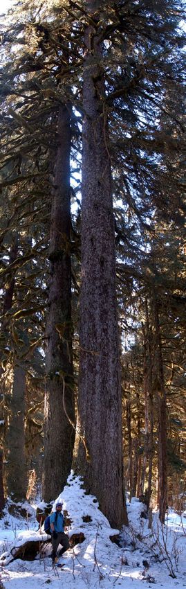
6 • Cowee hike

17

                 Red squirrels left clusters of shredded
                 hemlock cones, and porcupines had
                 recently chewed bark off shore pines.
                 Snow crust was so firm that Rick’s dog
                 barely left tracks, so we could easily
                 have missed the movements of mice and
                 voles.

                 Cowee Fan
                 17 From the lower-terrace fen, we
                 entered forest on the perceptibly sloping
                 fan, and soon started to see big trees.
                 Judging from my notes from the 1997
                 visits, I didn’t expect this. I remem-
                 bered pretty average hemlocks with a
                 blueberry understory. It’s probably true
                 that overall the outer portions of the
                 fan are less active and less productive
                 than the 5 acres at the confluence. But
                 in stereo we noted a linear strip of large
                 trees (blue arrow), and wondered if they
                 weren’t keying into nutrient delivery
                 along a paleochannel.
                     In a summary discussion at the
                 confluence, Koren pointed out that
                 there’s an unusual amount of red osier
                 dogwood on the fan. I assumed it was
                 concentrated in the most active inner

                 Our route and my photopoints on a georef-
                 erenced 1979 aerial. My best guess on the
                 Landmark Tree acre is outlined in red. See
                 following version for delineation of large-
                 tree patches.
richard.carstensen@gmail.com 7

            Obliques from a flight
                 in August, 2005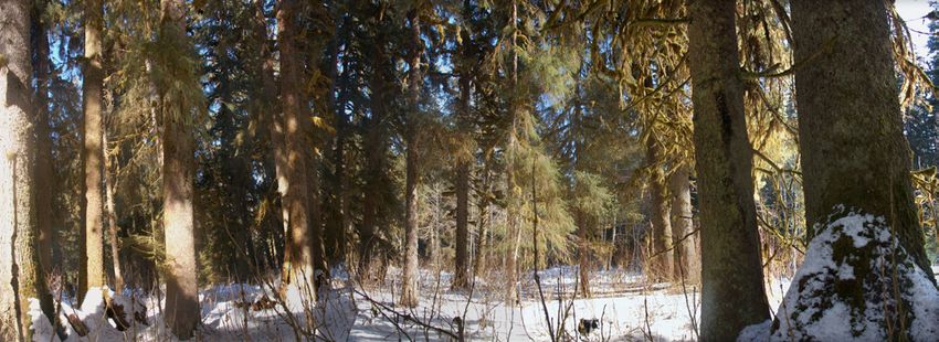
8 • Cowee hike

                 16

                 level, but scanning the foreground of pano 17, I notice that
                 even here near the fan edges, purple, opposite-branching
                 stems of Cornus stolonifera are common.
                     16 For awhile we followed an old, melted-out wolf trail.
                 Must be pretty slim pickins for wolves in upper Cowee.
                 Kevin said he saw buds of elderberry removed by something,
                 but we didn’t see a single deer track on the entire walk.
                 Goats use the high meadows and cliffy forests, but offer only
                 a tough, occasional meal for wolves. That leaves little but
                 beaver, porky and smaller, hor-d’oeuvre-sized rodents.
                     19 What’s really exceptional about the Cowee spruces
                 is their height. I didn’t bring the laser, but we probably saw
                 several trees pushing 200 feet. Because the trunks are widely
                 spaced, you can easily see into the crowns. It’s a young
                 stand, so diameters aren’t especially large. Plenty of 5 and
                 6-footers, but no true pumpkins.
                     23 Close to the South Fork we paused in a magnificent
                 stand, more active than any we passed through coming from
                 the southwest. Checking our GPS track, coming and going
                 through the fan to the confluence, I’m now thinking we
                 never passed exactly through the acre we assessed in 1997
                 (see track compared to red outline on preceding aerial).
                 But this panorama #23 shows pretty much the same forest
                 type. Devil’s club dominates the understory, with none of
                 the upland deer-forage species. Lots of red osier dogwood,
                 which I associate with limey parent material and (often)
                 human disturbance. This is an important species on the
                 Chilkat River flood plain, which is similarly a gappy, well-lit
                 forest on very active alluvium.
                 This is the way I conceptualized the active (darker) and inactive
                 (paler) parts of the fan in an earlier sidebar on Cowee’s Holocene
                 and Neoglacial history. I now think it’s too simplistic. See follow-
                 ing aerial with hyporheic arrows. Lidar contours (Rick secured
                 $150,000 for this!)
                 will explain a lot
                 about the distribu-
                 tion of large-tree
                 forest on the fan.

19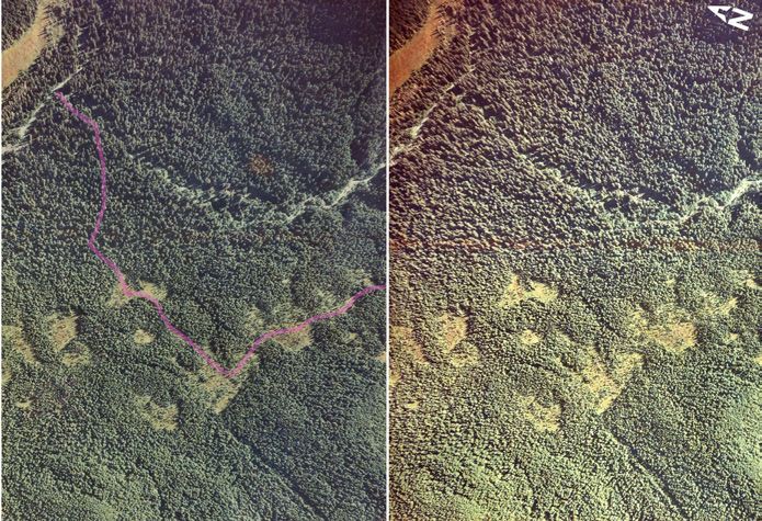
richard.carstensen@gmail.com 9

                                                                                                   23
    There are almost no hemlocks in this stand, and minimal
subcanopy layer. It’s basically a first generation forest, with
most trees in the 150-to 180-foot range (histogram).
    Although snow covered the ground, we could make out
the alignment of shallow overflow channels lacing through
the trees. Over-bank floods must occur here at least once per
decade.
    24 We continued north to the confluence, and ate lunch
on the only exposed cobble bars. I had hoped to find more
of these bars for easy streamside walking, but water level
in both the mainstem and South Fork is so low that daily/
weekly fluctuations have not trimmed away the snowpack.
    Rick pointed out that the cobbles at the confluence are
predominantly flattened slate & phyllite, whereas the mate-
rial just upstream on the mainstem is a more rounded mix of
many rock types including granitics from the tonalite pluton

I traced these ovals on the 1979 aerials under a stereoscope,
selecting gappy stands, 50% taller than matrix. Then rotated
north-up. Size of blue arrows shows suggested strength of hypo-
rheic delivery to tree roots.

                                                          24
10 • Cowee hike
                                                                                         1979 USFS aerials of
                                                                                         the confluence area.
                                                                                         Stereopair for 3D view-
                                                                                         ing. North is left. Pink
                                                                                         line is our route. See
                                                                                         preceding (north-up)
                                                                                         rectified version for
                                                                                         more detail on topogra-
                                                                                         phy, photopoints, etc.
                                                                                             In the upper left
                                                                                         corner, note the pale
                                                                                         crowns of recently
                                                                                         killed spruces between
                                                                                         the bog and the creek.
                                                                                         Those snags had fine
                                                                                         branches 30 years ago
                                                                                         but may have mostly
                                                                                         fallen by now. They’ve
                                                                                         been replaced by more
                                                                                         recently killed trees,
                                                                                         according to Koren,
                                                                                         that show green on this
                                                                                         historic stereopair.

comprising the crest of the watershed. Moving down-      system. In the distance, note the large spanning log
stream from the confluence, Rick was surprised to see    that would have been dislodged from a flashier chan-
the phyllite component from the South Fork domi-         nel. Another spanning log was embedded in the creek
nating in the cobble bars, odd since its flow in most    bottom immediately above the confluence. It forms
seasons is only a fraction of the mainstem’s. Possibly   a mini-waterfall at low water. I was intrigued by this
this is an “illusion,” created by the flattened slate-   indication of long-term bed stability.
phyllite cobbles “floating” higher than the rounded          I found no mink or otter tracks on the creekside
and maybe heavier material, thus covering more of the    snow, which in retrospect seems odd. The confluence
surface.                                                 should be a mustelid hot spot. We were relieved to
    25 I walked a bit upstream along the mainstem.       see that the trapper trail stopped in Bessie saddle, and
During late-summer high flows, Cowee probably            didn’t drop into the Cowee headwaters. So at least this
reaches nearly to the top of the ~3-foot cutbank show-   area is apparently free of human predation.
ing on the left side of this panorama. But there are         Rick and Koren wanted to examine the unusual,
several indications that the stream is not as power-     linear bog on the north side of the mainstem. It
ful as you might expect from a turbid, glacially fed     stretches for 0.8 miles in a long crescent shape

 25
richard.carstensen@gmail.com 11
Above: Our core from the 144-cm spruce at photopoint 29.
Brown lines on the right show presumed orientation of inner 29
rings. • Right: Kevin coring the codominant spruce. Note red-
osier dogwood in foreground.
Faded, 14-year-old
28 witness tree tag on
cottonwood at conflu-
ence. From here it’s
314 ft @ 217o to point
1 of our 5-pt clus-
ter in LT #9. Inset
shows original color, &
numbered tag initially
used to mark the “Big
Tree” in each LT stand.
that shows well on the preceding 2005 oblique aerial. more confident in the ability of GPS to archive
We wondered about the underlying sediments. It seems the plot locations, and also we began to consider
unlikely this could be a stream terrace. Streams do leave it arrogant to leave metal on the most magnificent
patches of poorly drained fines in elevated terraces, but trees of the Tongass. Here, in the case of Cowee
they’re generally interspersed through a matrix of well- LT stand #9, I can appreciate arguments on both
drained alluvium. I’ve never seen a patch of alluvial fines sides. Now that it’s an Experimental Forest, some-
this extensive. My guess is that during the early Holocene, one may well want to relocate and remeasure our
marine fines were deposited here, as beneath the other, exact LT acre.2
smaller fens and bogs we passed through. This one lies at 29 While the rest of our team explored the
about the 100 foot contour, while the peatlands north of bog, Kevin and I retraced our tracks back into
Bessie saddle range from 200 to 500 feet. the forest, in search of a good tree to core. We
Koren reported a mysterious fringe of large, recently picked a codominant 5-footer that lacked strong
killed spruces between the bog and the creek. What’s going root flare,3 to increase our chances of reaching
on here? Beaver can’t explain it, although they are prob- near the pith with my 24-inch borer. Because the
ably responsible for the “beaver swamp” south of the creek long one is so hard to turn, we went in first with
that I marked on the preceding 2005 up-valley oblique. my 18-incher, drilling from the “upside” of the
On the preceding 1979 stereogram it’s clear that trees slight lean, for less distance to pith. Note in the
have been dying here for a long time. Does this indicate sample above that ring width decreased smoothly
an expanding front of mortality that will eventually reach throughout the tree’s life, as expected in a crown
right down to the stream bank? If so, what is driving it? I codominant that was never suppressed beneath
didn’t ask Koren if she saw pitch-outs from bark beetles, taller trees. Because center rings were large, our
but the long duration suggests something abiotic, such as error in estimating date of germination is probably
changing groundwater behavior. small.
28 In the early days of the Landmark Trees project,
2 On the other hand, I would not be offended if some
when GPS was in its infancy, we tagged not only the larg- future hiker finds this tag obnoxious and removes it.
est tree in each Landmark acre (the “Big Tree”), but also a As Ed Abbey said, “There comes a time when a man
witness tree. For lack of a better symbol, we used a hiker has to pull up stakes.”
3 Spruces on really active alluvium sometimes appear
icon for the witness tree tag. It’s still there on a big cotton- to dive straight into the substrate like telephone
wood at the confluence. We only used this marking system poles. This is because over-bank deposits have piled
for the first dozen or so of our 76 plots. Later, we grew additional sediment around the swollen part of their
bases.12 • Cowee hike
Bessie saddle pond from a flight
32 in February, 2004.
As John Caouette conclud-
ed from his coring here in
1997, it looks as though this
magnificent forest is just a
“teenager,” in tree years. A
germination date of about
1830 is consistent with my
assumption that the more
active parts of the confluence
fan were “set back to zero” at
the peak of the Little Ice Age
(~mid-1700s). In the early
1800s, things had stabilized
enough for spruces to colo-
nize. Slightly higher elevation-
ally on the fan, trees are prob-
ably older. But I’d be surprised
if even the biggest, such as the
spruce in photo 19, are much
more than 300 years old.richard.carstensen@gmail.com 13
When the boggers rejoined us
in the forest, I recorded a multi-
disciplinary conversation on the
zoom H2, ranging from hydrology
to botany to wildlife. Maybe I’ll
eventually incorporate these obser-
vations and ideas into a narrated
slide show on Heen Latinee.
32 On the way home we didn’t
stop much except to adjust packs 35
and footgear. This shot of the
beaver-drowned pond-fringe was 36
close to the lodge on the oblique
aerial.
35 Descending to the road,
we found this weasel track that
we must have overlooked going
in. Typical long-short-long-short
loping gait. I think it’s the only
mustelid track we saw all day
- should ask Kevin if he found
others, especially on the stream.
36 While waiting near the trail-
head, I quick-cored an alder that I
assumed had probably colonized
on the disturbed margins of the
old plank road. After download-
ing the photopoint (see 1979 CIR
on page 2) I realized this lowest
portion of Bessie Trail is not on
the historic road. I didn’t save the could not be related to trail-building keyed to the new highway. Assuming
core but Kevin counted 56 rings the alder (and many others the same size fringing the trail here) gives us an
to pith. Adding a decade for years approximate date for trail construction, this post-plank-road route probably
to core height, that would make it connected Yankee Cove to Bessie saddle before the highway transected it.
about 70 years old, with germina-
tion around the year 1940. At that Thanks! to Rick, Paul, Koren and Kevin for fine company and nature-
time, Glacier Highway had not sleuthing in Juneau’s most awesome watershed!
yet crossed Herbert River, so thisYou can also read