WATER EROSION RISK AND SOIL LOSS ESTIMATION IN VOLCANIC GEOMORPHOLOGICAL LANDSCAPES OF MEXICO
←
→
Page content transcription
If your browser does not render page correctly, please read the page content below
Cultivos Tropicales, 2016, vol. 37, no. 2, pp. 45-55                                                                           April-June

                                  ISSN impreso: 0258-5936                         Ministerio de Educación Superior. Cuba
                                  ISSN digital: 1819-4087                         Instituto Nacional de Ciencias Agrícolas
                                                                                  http://ediciones.inca.edu.cu
DOI: 10.13140/RG.2.1.3942.5527
http://dx.doi.org/10.13140/RG.2.1.3942.5527

WATER EROSION RISK AND SOIL LOSS ESTIMATION
IN VOLCANIC GEOMORPHOLOGICAL LANDSCAPES
OF MEXICO
                     Riesgo de erosión hídrica y estimación
       de pérdida de suelo en paisajes geomorfológicos volcánicos en México
Oyolsi Nájera González, José I. Bojórquez Serrano),
Fernando Flores Vilchez, Rafael M. Murray Núñez
and Areli González García-Sancho
ABSTRACT. This research work assesses erosion risk and                      RESUMEN. Se evalúa el riesgo de erosión y pérdida de
soil loss in volcanic geomorphological landscape units from                 suelo sobre unidades de paisaje geomorfológico de origen
Mololoa river basin, Mexico, by applying the universal soil                 volcánico en la cuenca del río Mololoa, México, aplicando
loss equation based on geographic information systems.                      la ecuación universal de pérdida de suelo, con el apoyo de
Natural resources of this Nayarita territorial region have                  sistemas de información geográfica. Los recursos naturales
favored the economic development and establishment of                       de esta parte del territorio nayarita han favorecido el
this state capital; however, such relationship, lacking an                  desarrollo económico y el establecimiento de la capital de
environmental criterion planning, has caused their quick                    Estado; sin embargo, esta relación carente de una planeación
deterioration, mainly in soils, which in time can result in                 que incorpore criterios ambientales, ha repercutido en
low levels of the territorial users’ well-being. According                  un deterioro acelerado de los mismos, sobre todo a los
to these results, 57,6 % geomorphological landscapes of                     suelos, que en el tiempo, puede traducirse en bajos niveles
the studied area show very high and high erosion risk,                      de bienestar de los usuarios del territorio. Los resultados
corresponding to “Sierras de San Juan” and “Volcan” units,                  muestran que 57,6 % de los paisajes geomorfológicos del
volcanic hill slopes associated with “Sangangüey” volcano                   área en estudio presentan riesgo de erosión muy alto y alto,
and “Tepeltitic” volcano slopes. In turn, 66 % of the studied               que corresponden a las unidades “Sierras de San Juan” y
territory present some level of water erosion; 13,7 % of the                “Volcán”, laderas de sierra volcánica, asociadas al volcán
basin surface have significant soil losses by water erosion                 “Sangangüey” y laderas del volcán “Tepeltitic”. Por su
(very high and high); 16,6 % show a moderate soil loss                      parte, el 66 % del territorio en estudio presenta algún nivel
whereas 35,7 % have lost less than 10 t ha-1 year-1.                        de afectación por erosión hídrica; el 13,7 % de la superficie
                                                                            de la cuenca presenta significativos problemas de pérdida
                                                                            de suelo por erosión hídrica (muy alta y alta); el 16,6 %
                                                                            presenta una pérdida de suelo moderada y el 35,7 % presenta
                                                                            pérdidas menores a 10 t ha-1año-1.

Key words: universal soil loss equation, geographic                         Palabras clave: ecuación universal pérdida de suelo,
           information system, water basins river,                                          sistema de información geográfica,
           Nayarit                                                                          cuencas hidrográficas, río, Nayarit

INTRODUCTION                                                                costs through its effects on agricultural production,
                                                                            infrastructure and water quality, which in turn affect
     Water erosion is the most significant problem                          population quality, even threatening food security
on soil degradation in the world, since it causes                           and representing a serious problem for sustainable
serious environmental impacts and high economic                             development (1, 2, 3, 4, 5, 6); it is also associated
Universidad Autónoma de Nayarit, Ciudad de la Cultura “Amado Nervo”,        with soil organic carbon emission to the atmosphere
Tepic, Nayarit, México, C.P. 63190.                                         as CO2, thereby to global warming (7).
) iranbojorquez@hotmail.com

                                                                       45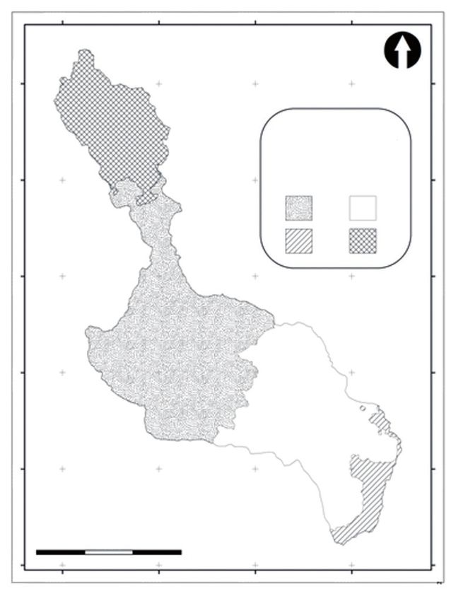
Oyolsi Nájera González, José I. Bojórquez Serrano, Fernando Flores Vilchez, Rafael M. Murray Núñez and Areli González García-Sancho

     This form of degradation has gained worldwide                   conditions of water erosion whereas 30 % of the
interest (8, 9) and has been documented by several                   remaining area has high and very high soil erosion
studies focused on assessment, risk analysis,                        levels (28); meanwhile official data register that
mapping and monitoring at different scales; erosion                  18 % of the state territory is affected by this
scenario modeling and building (8, 10, 11). These                    problem (27), which represents an approximate
works have been carried out simultaneously with the                  rate of 25,000 hectares affected per year and if
development and application of various models, such                  this deterioration rate is kept as such, perhaps
as USLE (12), EPIC (13), WEEP (14), SWAT (15),                       in 40 years, the entire territory will be somewhat
RUSLE (16), just to mention some of them. However,                   affected by water erosion.
the Universal Soil Loss Equation (USLE) or any of its                     Despite this is a serious problem, there
modifications or reviews (RUSLE/MUSLE) constitute                    are few reports published in details, which is
the most widely used model for assessing soil loss                   essentially considered for an effective planning
by water erosion (17, 18); although this model is                    development in land management and agricultural
considered to strongly overestimate its assessments                  activities (1).
(8), it is one of the most broadly applied to some                        Volcanic landscapes represent appropriate and
European countries (19).                                             important geomorphological units for water erosion
     In parallel, Geographic Information Systems                     studied at basin level (3). From its delineation and
(GIS) have proved to be a useful tool in estimations,                spatial representation as well as the description
since it enables to store, process, handle and                       of its genesis, relief and current dynamics, it is
display spatial databases, so representing a good                    possible to establish its environmental fragility
supporting alternative in planning and managing                      status; thus, this study is relevant with practical
natural resources, which helps users improve their                   and ecological value for different disciplines. From
decision-making processes (20, 21).                                  a practical point of view, it offers the opportunity to
     Soil erosion is a generally slow natural process;               evaluate the territory or landscape in a geographic
however, it has become a deteriorating problem                       framework that supports agricultural, livestock and
now, due to man’s hastening, which has affected                      forest sector planning, in order to avoid lower rates
throughout history about 2,000 million hectares                      of crop production, proposing soil use modifications
of land in the world (22, 23); in the last 40 years,                 and sustainable management strategies (7, 29);
almost a third portion of the world’s arable lands                   from an ecological point of view, it offers the
have been lost due to this phenomenon and it                         opportunity to keep particularly soil ecosystem
continues to be lost at higher rates than 10 million                 functionality (3).
hectares per year. In this regard, it is estimated that                   This study was aimed to assess water erosion risk
80 % of planet surface presents this phenomenon                      and soil loss in volcanic geomorphological landscapes
(11) and approximately 66 % of arable lands are                      of Mololoa river water basin, Nayarit, Mexico.
degraded by water erosion (24); individual cases
have estimated soil loss rates of 17 t ha -1 year -1                 MATERIALS AND METHODS
for USA; 30 to 40 t ha -1 year -1 for Asia, Africa and
South America, mainly caused by inappropriate                             Mololoa river basin is located at the central part
agricultural practices (25); 5,5 t ha -1 year -1 of                  of Nayarit state (Figure 1), between the geographical
German arable lands (23) and rates above 50 t ha -1                  coordinates 21°43’26” north latitude, 104°56’46” west
year -1 for Spain (9), a situation that has led to give              longitude and 21°16’12” north latitude, 104°43’06”
up agricultural lands across Europe (26).                            west longitude. It spreads over 618 km2 and is part of
     In Mexico, it is estimated that 80 % of the                     Lerma-Chapala-Santiago hydrological system. This
territory is affected by this process (22); official                 region of nearly 2 % of the state territory has provided a
sources report that 22,73 million hectares of the                    set of goods and services to residents from 34 villages
country have water erosion; 56,4 % out of them are                   settled therein; unfortunately, this relationship, lacking
considered light; 39 % moderate, 3,7 % strong and                    an environmental criterion planning, has caused a
0,2 % extreme (27).                                                  quick deterioration of its natural resources, such as
     At the local level, water erosion estimates                     decreased forest and wetland areas, changes in water
for Nayarit seem to be inconsistent, as some                         quantity and quality, air quality, soils and possible
have reported that more than 60 % of the State                       climatic implications, which over time have resulted in
agricultural region presents light and moderate                      low levels of territorial users’ welfare.

                                                                46
Cultivos Tropicales, 2016, vol. 37, no. 2, pp. 45-55                                                                             April-June

                                                                                 activities have already ceased: the former during the
                                                                                 tertiary period and the latter remained even active in
                                                                                 the quaternary. It has an annual mean temperature
                                                                                 from 21 to 22 °C in most of the territory, although it has
                                                                                 warmer conditions (24-26 °C) downwards. Its annual
                                                                                 mean rainfall is 1000-1200 mm; however, some small
                                                                                 areas reaches up to 1500 mm. Soil is differently
                                                                                 formed between both riversides, either because of
                                                                                 its source material (acidic in San Juan, basic and
                                                                                 ultrabasic in Sangangüey) or its age (tertiary and
                                                                                 quaternary, respectively).
                                                                                      Geomorphological landscapes were obtained by
                                                                                 applying the physiographic approach (30), based on
                                                                                 the relief unit description according to their genesis
                                                                                 and current modeling processes, besides identifying
                                                                                 soil processes and types formed in each described
                                                                                 unit. The units defined in this study were grouped
Figure 1. Studied area                                                           into three hierarchical levels (Figure 2), starting from
                                                                                 a photo-interpretation and relief analysis of digital
     It is shaped like a high valley between San Juan                            ortho-photos distributed by the National Institute
structures (2240 m above sea level) in the west and                              of Statistics and Geography (NISG). On the other
Sangangüey (2180 m above sea level) in the east,                                 hand, data from soil profiles (31) associated at GIS
going downwards to the river banks between 920                                   to relief units were used to identify predominant soil
and 900 m high above sea level. Both San Juan and                                types in each unit.
Sangangüey are ancient volcanic formations, whose                                                                   2400000

                                                    500000        510000           520000                 530000
                                      2400000
                                      2390000

                                                                                                                    2390000

                                                                                     Erosivity in Mololoa river
                                                                                     basin, Nayarit, Mexico

                                                                                           R Factor
                                                                                           Symbology
                                                                                             229,46        252,59
                                      2380000

                                                                                                                    2380000

                                                                                             244,54        270,62
                                      2370000

                                                                                                                    2370000
                                      2360000

                                                                                                                    2360000
                                                                                                                    2350000
                                      2350000

                                                         Meters
                                                0                  15,000
                                                    500000        510000           520000                 530000

                              Figure 2. Erosivity (R factor) in Mololoa river basin, Nayarit

                                                                            47
Oyolsi Nájera González, José I. Bojórquez Serrano, Fernando Flores Vilchez, Rafael M. Murray Núñez and Areli González García-Sancho

     Soils were classified according to the World                    geomorphological landscape. P factor (management
Reference Base (32), whereas soil loss and risk                      practices) was determined for each unit using
were calculated at the geomorphological landscape                    agricultural soil (12), whereas P value equals to 1 in
level by the Universal Soil Loss Equation (USLE)                     areas with scrub and forest vegetation.
(12), an empiric-parametric mathematical model                             Finally, under GIS environment (ArcView 3.2),
for indirect soil loss assessment through water                      different layers (geomorphology, erosivity, erodibility,
processes, developed by Wischmeier & Smith at                        slope, cover and management) were superimposed to
Purdue University in USA, which is still the highly                  estimate erosion risk and soil loss. Different maps and
applied model nowadays, due to its accuracy and                      its results are at 1: 25000 scale.
relative universal applicability (33, 34, 35).
                                                                     RESULTS AND DISCUSSION
                     A= R*K*SL*C*P
where:                                                               Geomorphological landscapes
A (soil loss, t ha-1 year-1)
                                                                          Five denuded environments and a cumulative
R (rainfall erosivity, mm)
                                                                     one were identified in the studied area, with a total
K (soil erodibility that expresses soil loss rate per EI
                                                                     of 15 geomorphological landscapes and 36 relief
unit for a specific soil)
                                                                     types (Table I). In general, denuded landscapes
SL (relationship between slope length and gradient)
                                                                     are represented by volcanic shields with explosion
C (soil cover)
                                                                     boilers (Tepic and Tepeltitic), volcanic mountains and
P (management practices); the latter three have no
                                                                     strata-volcanoes (San Juan and Sangangüey), hills
measurements
                                                                     associated with volcanic structures and hill surfaces
                                                                     with small valleys at the bottom of Mololoa river
     Rainfall erosivity (R) was estimated by
                                                                     basin; meanwhile cumulative landscapes correspond
means of monthly and annual precipitation data
                                                                     to “Matatipac valley” made by foothills associated to
recorded in three weather stations managed by
                                                                     volcanic structures and alluvial plains of La Labor,
the National Water Commission located within the
                                                                     Xalisco and Tepic.
studied area; the influencing area of each one
                                                                          In general, the most frequent Soil Reference
was delimited with Thiessen’s polygon method
                                                                     Groups (SRG) are Cambisols (CM), Andosols (AN),
(36) and rainfall erosivity index was calculated
                                                                     Regosols (RG), Luvisols (LV), Acrisols (AC), Leptosols
through Fournier’s modified index, which not only
                                                                     (LP), Feozems (PH), Umbrisols (UM) and Gleysols
considers the wettest month rainfall, but also that
                                                                     (GL), the latter ones filling geomorphological landscape
of the other months.
                                                                     depressions.
         12   p2i                                                         Results from different USLE factors for every
    R= ∑
        i=1   P                                                      geomorphological landscape are presented as follows:
where:                                                               Erosivity (R). Average erosivity value calculated for the
i (month number)                                                     studied area was 249,3 mm, thereby it was estimated
p (monthly rainfall, mm)                                             as a moderate erosivity (39), which is lower than the
P (average annual precipitation, mm)                                 value reported for Nayarit (283 mm); however, annual
                                                                     records reported in weather stations are greater than
     Erodibility (K) was estimated from data of every Soil           1,000 mm (40). It can be observed that the highest
Group Reference present in each geomorphological                     erosivity values occur south of the basin, whereas the
landscape reported for the area (31) and applied                     lowest ones are at the center (Figure 2).
to erosivity nomogram (37). Topographic SL factor
was calculated through the average slope in each                     Erodibility (K). For erodibility, the most susceptible soil
geomorphological landscape unit estimated from the                   properties to erosion were taken into account. Thus,
digital altitude model made with vector information                  top soil texture, organic matter content and soil depth
(contour lines) generated by NISG and supported by                   were considered for SRG. These properties provide
GIS tools.                                                           different susceptibility levels to rainfall action, which
     For C factor (cover), results of rising land cover              allowed grouping them into five levels (Table II).
and soil use reported for the studied area were
employed (38), calculating cover percentage in each

                                                                48
Cultivos Tropicales, 2016, vol. 37, no. 2, pp. 45-55 April-June
Table I. Geomorpho-edaphological heading of Mololoa river basin, Nayarit
Morphogenetic Geomorphological landscape Relief type Soil association
environment
Volcanic shield Tepeltitic boiler explosion slopes Tepetiltic lava defile LV-CM-RG
with boilers Slag cones associated with Tepeltitic LV
Hillsides associated with Tepeltitic boilers LV-CM
Tepeltitic boiler explosion slopes Tepeltitic boiler explosion slopes LP-UM-LV
Hills Hills associated with SAMAO Hills associated with SAMAO and volcanic
LV-RG-PH
and volcanic gap gap
Hills associated with San Juan Hills associated with San Juan AN-RG-LV-UM
Hills associated with Sangangüey Hills associated with Sangangüey and
LV-UM-GL
and pyroclasts pyroclasts
Medium high hills covered with
Medium high hills covered with acid dog-end LV-RG-PH
acid dog-end
Volcanic hills Sangangüey volcanic building Lava defile covered by pyroclasts LV-UM-LP-PH-GL
Denuded environment
with volcano Slag cones associated with Sangangüey LV-PH-UM-LP-GL
strata Inner slope crater LP-LV
Slopes associated with the main crater LP-CM-LV
Volcanic hills Complex associated with Cerro
of steep slopes Alto volcano Complex associated with Cerro Alto volcano RG-CM-AN
“San Juan” Volcanic complexes associated Basalt define covered with dog-end CM-AC
volcano with San Juan Sierra de San Juan AN-RG-CM
Coatepec volcano AN
El Tacote volcano AN-RG-CM
La Huerta volcano and lava define AN-RG
Reliefs grouped to Pre-San Juan
Reliefs grouped to Pre-San Juan volcano RG-AN-CM
volcano
San Juan volcano Slag cones and northern lava RG-CM
Dome and lava flow CM-RG
Central structure and associated lavas RG-CM-AN
Hill surface Volcanic hills Mountain sides and hills LV-CM-AC-LP
(lower basin Valleys with hills Alluvial valley with Santiago river mouth AC-CM-UM
slopes) Valle with low hills AC-CM-UM-LV-FL
Valley with intermediate hills AC-LV-CM-UM-NT-FL
Alluvial plain Foothills Foothills associated with San Juan AN-RG-LV
Foothills associated with Sangangüey UM-LV
Colluvial-alluvial foothills associated with
Cumulative environment
LV-CM-UM
Sangangüey
Foothills associated with Tepic boiler LV-LP-UM
Colluvial-alluvial foothills associated with San Juan AN-RG
Plains Seasonal flood plains GL-LV-UM
Partially filled ordinary flood plains LV-UM-CM
La Labor valley plains LV-GL-LP-PH-RG
Matatipac valley plains UM-LV-GL
Denuded plains LV-UM-GL-RG
Table II. Soil erodibility levels in Mololoa river basin, Nayarit
Erodibility classes Erodibility ranges Main soil properties
Very high > 0,04 Soils with sandy loam and Sandy texture, poorly shallow with low organic
mass content
High 0,03–0,033 Soils with sandy loam texture, mid to low shallow with low organic mass
content
Medium 0,02–0,026 Soils with sandy loam and loam texture, mid shallow with mid organic mass
content
Low 0,001–0,009 Soils with clay loam and clay texture, mid shallow with mid to high organic
mass content
Very low 0,009-0
Soils with clay loam and loam texture, deep with high organic mass content
49Oyolsi Nájera González, José I. Bojórquez Serrano, Fernando Flores Vilchez, Rafael M. Murray Núñez and Areli González García-Sancho
Most basin area has soil associations with valley plains of La Labor and Matatipac. Very steep
low erodibility (12719 ha), developed on hills and slope conditions are observed in volcanic structures
foothills in San Juan and Sangangüey; lava defile (complexes, buildings and volcano) in San Juan and
in Tepeltitic as well as some slag cones and plains Sangangüey as well as in volcanic mountains (basin
in Matatipac Valley. Cambisol units well represented bottom). Also, moderate and strong conditions of
by its surface area (4884 ha) are some defiles this factor are joined to these units and extended
and foothills in Sangangüey. The gleyic and haplic towards the explosion slopes of Tepeltitic, foothills
Luvisols are reported in defiles covered by dog-end, of Sangangüey and grouped reliefs of pre San Juan.
grouped reliefs of pre San Juan and boiler foothill of Very mild slope conditions are associated with those
Tepic covering 2459 ha. There are Acrisol-Luvisol cumulative units represented by Matatipac valley
associations in low slope areas, such as Matatipac plains, hill valleys and foothill of Sangangüey.
Valley plains and small foothills in Sangangüey Soil cover (C). Soil cover takes the value of 0.80 as
extending about 2861 ha. a parameter for temporary agricultural areas (9). In this
Seasonal flooding plains have vertic and eutric sense, a bare soil has greater erosion risk; agricultural
Gleysol associations (2,301 ha). Hill units covered soils are usually more susceptible, due to the influence
by pyroclasts and acid dog-end as well as some of human management; meanwhile forests and woods
denuded plains have Acrisol-Regosol associations have lower susceptibility (0,50 %), because they are
distributed in approximately 2022 ha. Results from protected against rainfall kinetic effect.
soil erodibility obtained for the area under study are This factor is summarized in Table IV for the
consistent with those reported for Nayarit: 72 % of studied area, where 44 % of the basin presents a
the territory has moderate, 25 % lighter and 3 % high erosion susceptibility condition, followed by a low
higher erodibility (40). condition (37,9 %); the first is associated with the types
Slope length and value (SL). Results from different of farmland cover, either perennial or annual, mainly
relief types of the studied area were grouped into five sugarcane-growing areas and different associations
categories (Table III), according to their magnitude and in which it is predominant. In contrast, low erosion
surface area; it can be seen that most basin portion susceptibility condition is associated with the types of
has a mild condition, such areas are represented by natural vegetation cover; that is, oak, pine and mixed
explosion boiler slopes of Tepic, hills with volcanic gap forests, as well as their associations with other covers;
associated with SAMAO and covered by pyroclasts mid wood units and secondary associations. This
associated with Sangangüey, as well as hills covered leads to recognize the important role of vegetation as
by acid dog-end, the foothills of San Juan and a mitigating factor of water erosion (41).
Table III. SL classes and ranges in Mololoa river basin, Nayarit
SL class SL rank (%) Surface (ha) Percentage ((to the total)
Very soft 0–11 2027,68 3,55
Soft 11–24 25797,62 45,29
Moderate 24–42 8191,45 14,38
Strong 42–118 4174,34 6,96
Very strong 118–339 13101,67 23,00
Table IV. Soil cover (C factor) in Mololoa river basin, Nayarit
C classes C value Surface (ha) % Types of associated covers
Low 0,50 21610,9 37,9 Cover types of the large group: natural and secondary vegetation
Moderate 0,65 9902,9 17,4 Grasslands and associations of this cover type; cover types of the large
group of buildings: rural and urban
High 0,80 25097,5 44,0 Cover types linked to the large group: farmland: annuals and perennials
Very high 1,00 189,7 0,33 Cover types linked to the large group of bare lands: mines of stone
materials
50Cultivos Tropicales, 2016, vol. 37, no. 2, pp. 45-55 April-June
Management practices (P). For this factor, covers Results show that 65.8 % of basin surface
were graded into five classes, according to the corresponds to denuded landscape. Then, 17761,4 ha
efficiency against soil loss, where values close to (31,1 % out of the total study) have very high erosion
the unit represent low efficiency covers or practices risk; geomorphological units that have this condition
(Table V). are Sierras de San Juan, some elements associated
For the studied area, units with the lowest with Sangangüey volcano and Tepeltitic volcano
e ff i c i e n c y v a l u e s ( 1 , 0 , 9 - 0 , 9 5 ) c o r r e s p o n d slopes. So, 26,5 % of the basin (15095 ha) has a
to those identified as stone material mines, high erosion risk condition. Geomorphological units
extending over an area of 189,69 ha; annual associated with this condition are hill slopes and slopes
crops, practically represented by sugarcane and associated with Sangangüey volcano and Tepeltitic as
American aloe-growing lands, which represent well as foothill and reliefs of San Juan.
43,5 % (24,779,55 ha) of the total area under In these units, the most widespread SRG are
study. Oak and pine forests, woods, grasslands, Andosols, Cambisols and Regosols. Andosols, even
though they may have a good organic matter content,
secondary associations and perennial plantations
are very susceptible to erosion, because aggregate
(mainly avocado) representing 45,9 % of the total
structural stability is weak, also its texture is sandy
study were ranked with high efficiency (0,1 and loam to sandy; meanwhile Cambisols and Regosols
0,02 ), since they stand for covers giving higher are shallow, with low organic matter and sandy loam
efficiency against erosion process, without being texture. They are usually well-drained soils but very
control practices. susceptible to erosion, so they should be kept under
So, 10 % of the basin was ranked with very high permanent cover, especially Andosols, which have
efficiency and covers associated with constructions good fertility (22).
correspond to these units, which represent a total Moderate erosion risk conditions were found in
transformation of natural elements by replacing them 4704,3 ha (8,25 %) at the top (mid high hills covered by
for artificial structures with concrete and brick that acid dog-end); average (hill valleys, foothills associated
make a waterproof cover to soils. with Tepic boiler) and bottom (intermediate hill valleys)
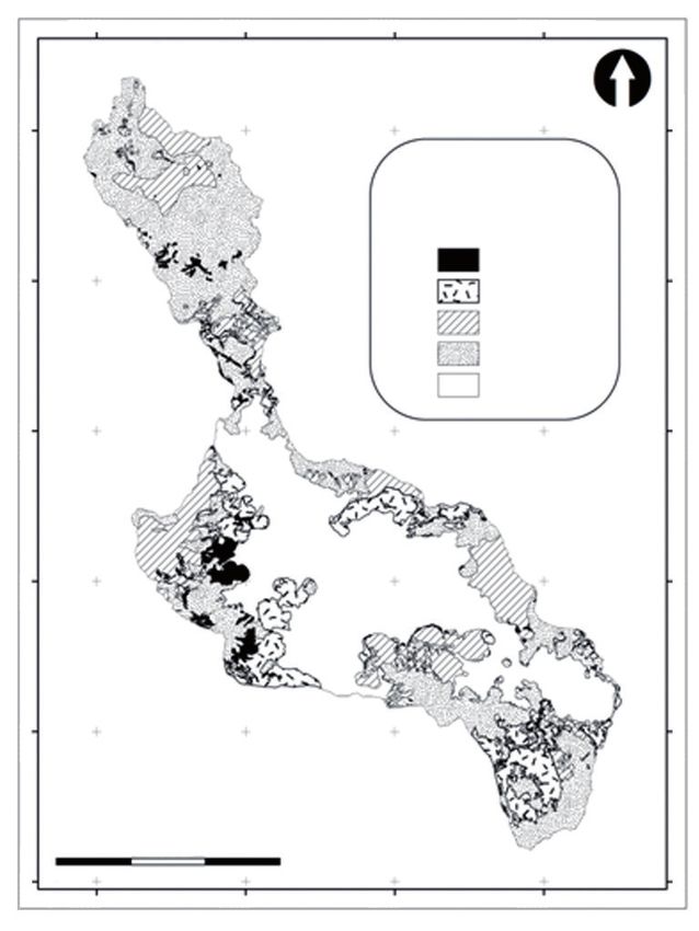
Erosion risk (ER). The erosion risk results from of the basin.
combining layers of climatic (erosivity), edaphic Soil loss (SL). Soil loss is calculated by combining
(erodibility) and topographic (length and slope) factors layers from climatic, edaphic, topographic, biological
supported by GIS tools; in turn, risk levels were and anthropic factors that characterize Mololoa river
adjusted from diagnosis (42), as shown in Table VI basin in GIS; results are classified according to the
and Figure 3. criteria applied to erosion risk, as it is summarized in
Table VII and are shown in Figure 4.
Table V. Management practices (P factor) in Mololoa river basin, Nayarit
Categories Ranks Surface (ha) % Description
Very low 1 189,69 0,33 Mines of stone materials
Low 0,9-0,95 24779,55 43,50 Sugar cane and American aloe crops
Moderate 0,5 76,20 0,13 Fruit crop
High 0,1-0,002 26185,71 45,97 Forest of oak, pine, mixed, grassland, secondary associations, avocado crop
Very high 0 5728,79 10,05 Rural, urban and service buildings
Table VI. Erosion risk in Mololoa basin river, Nayarit
Erosion risk Erosion risk ranges Surface Geomorphological landscapes
%
classes (t ha-1 year-1) (ha)
Complexes associated with Cerro Alto volcano, Dome and lava
Very high 200 < 17761,4 31,1
flow
High 50-200 15095,0 26,5 Central structure and lava; Sierra de San Juan, Tacote,
Coatepe and La Huerta volcanoes; hills covered by pyroclasts;
colluvial-alluvial foothill associated with San Juan and
Sangangüey; intermediate and low hill valley
Moderate 10-50 4704,3 8,25 Ordinary flood plains, seasonal and denuded; Boiler explosion
sides of Tepic
Light < 10 0,5 0 La Labor plains
51Oyolsi Nájera González, José I. Bojórquez Serrano, Fernando Flores Vilchez, Rafael M. Murray Núñez and Areli González García-Sancho
500000 510000 520000 530000
2400000
2400000
Erosion risk in Mololoa river
basin, Nayarit, Mexico
2390000
2390000
Symbology
Very high
High
Moderate
2380000
Light
2380000
2370000
2370000
2360000
2360000
2350000
2350000
Meters
0 15,000
500000 510000 520000 530000
Figure 3. Soil erosion risk in Mololoa river basin, Nayarit
Table VII. Soil loss in Mololoa river basin, Nayarit
Soil loss classes Soil loss ranges (t ha-1 año-1) Surface (ha) %
Very high 200 < 1305,05 2,3
High 50-200 6465,3 11,4
Moderate 10-50 9444,9 16,6
Light < 10 20346,2 35,7
Besides, 13,7 % of basin surface presents 2012 (27), who report 80 % of the national territory
significant soil loss problems by water erosion (high affected by this process and 18 % of the state territory
and very high), located in hills, volcanic complexes of affected by water erosion. At basin level, they are
San Juan and grouped reliefs to Pre-San Juan; the above the reported results for basin zone II of Burgos
foothill of Tepic boiler as well as hills and defiles of in Tamaulipas (43) and they seem to be similar to those
Sangangüey and Tepeltitic. reported for the micro-basin of Madin dam in the state
Moreover, 16,6 % of basin surface presents annual of Mexico (10).
moderate soil losses; these areas are located in San The role of natural or induced cover and
Juan and Cerro Alto volcanoes, the volcanic complex management practices (C and P factors of USLE) is
associated with San Juan, hills and volcanic building evident on soil loss; those areas showing high and very
of Sangangüey, some valleys areas with intermediate high erosion risk conditions reduced its surface up to
hills of the mid part of the basin and mountain slopes 42 % (Table VIII).
with hills from the low basin. The other basin surface, In this regard, some authors consider that
that is, 20346,2 ha (35,7 %) have lower soil losses water erosion extension and intensity are influenced
than 10 t ha-1 year-1. by several factors and the most significant one
In general, results show that 66 % of the studied is vegetation cover; this protective role is often
territory has some level of damage by water erosion; highly determining, so that when vegetation cover
this total is below the estimates reported for the country increases, there is an exponential decrease of
(22) and above state estimates of SEMARNAT in erosion rate (11).
52Cultivos Tropicales, 2016, vol. 37, no. 2, pp. 45-55 April-June
2400000
2400000
500000 510000 520000 530000
2390000
2390000
Soil loss in the basic of the
River Mololoa, Nayarit, Mexico
Simbology
Very high
High
2380000 Moderate
Light
2380000
ND
2370000
2370000
2360000
2360000
2350000
2350000
Meters
0 15,000
500000 510000 520000 530000
Figure 4. Soil loss risk in Mololoa river basin, Nayarit
Table VIII. C and P factor effect of USLE on erosion risk
Classes Risk of erosion (RE*) Soil loss (SL*) Effect of C and P** factor
High 15095,0 6465,3 8629,7 (42 %)
Very high 17761,4 1305,0 16456,3 (7 %)
* Surface in ha; ** Difference in ha between ER and SL
Vegetation cover and soil use are the most ♦♦ Besides, 30,3 % of the area exceeds soil loss of
important characteristics that best explain soil erosion, 10 t ha-1 year-1, with levels ranging from very high to
even surpassing the influence of rainfall intensity moderate. Hills, volcanic complexes of San Juan and
and slope gradient (40). Changes in soil cover and reliefs grouped to Pre-San Juan; the foothill of Tepic
use (forests substituted by cropping areas) have boiler as well as hills and defiles of Sangangüey and
led to dramatic soil erosion increases and results Tepeltitic present the most significant levels of soil
that can reach “carcavas” development, increasing
loss (very high and high).
river sediment load and contributing to form new
♦♦ San Juan and Cerro Alto volcanoes, the volcanic
sedimentary structures, such as river terraces and
deltas (40). complex associated with San Juan, the hills and
volcanic building of Sangangüey, some valley areas
with intermediate hills from the mid basin portion
CONCLUSIONS
and the mountain slopes with the lower basin hills
♦♦ Finally, 57,6 % of the studied area surpasses erosion showed a moderate condition (16.6 % of the area
risk of 50 t ha-1 year-1 (high and very high potential under study).
erosion); geomorphological landscapes showing
this condition are Sierras de San Juan, Volcano,
volcanic slopes of Sierra, elements associated with
Sangangüey volcano and Tepeltitic volcano slopes;
hill slopes and hillsides associated with Sangangüey
volcano and Tepeltitic as well as the foothill and
reliefs of San Juan. The predominant reference
soil groups in these units are Acrisols, Andosols,
Regosols, Cambisols and Feozem.
53Oyolsi Nájera González, José I. Bojórquez Serrano, Fernando Flores Vilchez, Rafael M. Murray Núñez and Areli González García-Sancho
♦♦ The role of natural land cover (forests, woods, 11. Sánchez, H. R.; Mendoza, P. J. de D.; De la Cruz, R. J. C.;
grasslands) and that induced by the man (crops) Mendoza, M. J. E. y Ramos, R. R. ‘‘Mapa de erosión
potencial en la cuenca hidrológica Grijalva-Usumacinta
is crucial in controlling water erosion, which is
México mediante el uso de SIG’’. Universidad y ciencia,
necessary, on the one hand, to reduce deforestation vol. 29, no. 2, agosto de 2013, pp. 153-161, ISSN 0186-2979.
and forest degradation (land use change) and to 12. Wischmeier, W. H. y Smith, D. D. Predicting rainfall
promote preservation and enhancement of forest erosion losses - a guide to conservation planning.
reserves through natural protected areas and [en línea]. (ser. griculture Handbooks (USA), no. ser.
537), edit. CAB Abstracts, 1978, 62 p., CABDirect2,
reforestation programs and, on the other hand, to
Record Number 19786726437, [Consultado: 14 de
encourage, maintain and improve good agricultural enero de 2016], Disponible en: .
with steep slopes. 13. Williams, J. R.; Renard, K. G. y Dike, P. T. ‘‘Viewpoint:
EPIC: A new method for assessing erosion´s effect
on soil productivity’’. Journal of Soil and Water
BIBLIOGRAPHY Conservation, vol. 38, no. 5, 1983, pp. 381-383,
ISSN 0022-4561.
1. Zhang, Q.; Wang, L. y Wu, F. ‘‘GIS-Based Assessment 14. Ascough, J. C.; Baffaut, C.; Nearing, M. A. y Liu, B. Y.
of Soil Erosion at Nihe Gou Catchment’’. Agricultural ‘‘The WEPP watershed model: I. Hydrology and
Sciences in China, vol. 7, no. 6, junio de 2008, erosion’’. Transactions of the American Society of
pp. 746-753, ISSN 1671-2927, DOI 10.1016/ Agricultural Engineers, vol. 40, no. 4, 1997, pp. 921-933,
S1671-2927(08)60110-8. ISSN 0001-2351, 2151-0059.
2. Mejia, J.; Dal Pozzo, F.; Montilla, P. y Torres, G. 15. Arnold, J. G.; Srinivasan, R.; Muttiah, R. S. y Williams, J. R.
‘‘Evaluación cuali-cuantitativa de la erosión hídrica ‘‘Large Area Hydrologic Modeling and Assessment
en la microcuenca Aguas Calientes, estado Mérida- Part I: Model Development1’’. JAWRA Journal of the
Venezuela’’. Revista Geográfica Venezolana, vol. 51, American Water Resources Association, vol. 34, no. 1,
no. 2, 2010, pp. 203-223, ISSN 1012-1617, 2244-8853. 1 de febrero de 1998, pp. 73-89, ISSN 1752-1688,
3. Maya, Y. ‘‘Diagnóstico ambiental de suelos erosionados’’. DOI 10.1111/j.1752-1688.1998.tb05961.x.
Tropical and Subtropical Agroecosystems, vol. 13, no. 2, 16. Hammad, A. A.; Lundekvam, H. y Børresen, T.
2011, pp. 169–179, ISSN 1870-0462. ‘‘Adaptation of RUSLE in the Eastern Part of the
4. Telles, T. S.; Guimarães, M. de F. y Dechen, S. C. F. ‘‘The Mediterranean Region’’. Environmental Management,
costs of soil erosion’’. Revista Brasileira de Ciência do vol. 34, no. 6, 12 de enero de 2005, pp. 829-841,
Solo, vol. 35, no. 2, abril de 2011, pp. 287-298, ISSN ISSN 0364-152X, 1432-1009, DOI 10.1007/
0100-0683, DOI 10.1590/S0100-06832011000200001. s00267-003-0296-7.
5. Sadiki, A.; Mesrar, H.; Faleh, A. y Chaaouan, J. 17. Verbist, B.; Poesen, J.; van Noordwijk, M.; Widianto;
‘‘Modelisation et cartographie des risques de l’erosion Suprayogo, D.; Agus, F. y Deckers, J. ‘‘Factors affecting
hydrique : cas du Bassin versant de l’oued Larbaa, soil loss at plot scale and sediment yield at catchment
Maroc’’. Papeles de geografía, no. 55, 2012, pp. 179-188, scale in a tropical volcanic agroforestry landscape’’.
ISSN 1989-4627. CATENA, vol. 80, no. 1, 15 de enero de 2010, pp. 34-46,
6. Pimentel, D. y Burgess, M. ‘‘Soil Erosion Threatens ISSN 0341-8162, DOI 10.1016/j.catena.2009.08.007.
Food Production’’. Agriculture, vol. 3, no. 3, 8 de agosto 18. Vich, A. I. y Mariani, A. ‘‘Evaluación y predicción de la
de 2013, pp. 443-463, ISSN 2077-0472, DOI 10.3390/ erosión hídrica en regiones áridas de relieve acentuado
agriculture3030443. del centro-oeste de Argentina’’. Multequina, vol. 19, no. 1,
7. Zhang, X.; Wu, B.; Ling, F.; Zeng, Y.; Yan, N. y Yuan, C. 2010, pp. 00–00, ISSN 0327-9375.
‘‘Identification of priority areas for controlling soil 19. Cantón, Y.; Solé-Benet, A.; de Vente, J.; Boix-Fayos, C.;
erosion’’. Catena, vol. 83, no. 1, 15 de octubre de Calvo-Cases, A.; Asensio, C. y Puigdefábregas, J. ‘‘A
2010, pp. 76-86, ISSN 0341-8162, DOI 10.1016/j. review of runoff generation and soil erosion across
catena.2010.06.012. scales in semiarid south-eastern Spain’’. Journal of
8. Romero, D. M. A.; Ruiz, S. J.-D. y Belmonte, S. F. ‘‘Tasas Arid Environments, vol. 75, no. 12, diciembre de 2011,
de erosión hídrica en la región de Murcia’’. Boletín de (ser. Deserts of the World Part IV: Iberian Southeast),
la Asociación de Geógrafos Españoles, no. 56, 2011, pp. 1254-1261, ISSN 0140-1963, DOI 10.1016/j.
pp. 129-153, ISSN 0212-9426. jaridenv.2011.03.004.
9. Duran, Z. V. H.; Francia, M. J. R.; García, T. I.; Arroyo, P. L. 20. Bonilla, C. A.; Reyes, J. L. y Magri, A. ‘‘Estimación de
y Martínez, R. A. ‘‘Mitigación de la erosión de suelos la Erosión Hídrica Empleando la Ecuación Universal
en plantaciones de almendro por cubiertas vegetales: de Pérdida de Suelo Revisada (RUSLE) y SIG en Chile
implicaciones para la agricultura sostenible de montaña Central’’. Chilean journal of agricultural research, vol. 70,
(SE España)’’. Comunicata Scientiae, vol. 3, no. 2, 28 no. 1, marzo de 2010, pp. 159-169, ISSN 0718-5839,
de junio de 2012, pp. 123-129, ISSN 2177-5133. DOI 10.4067/S0718-58392010000100017.
10. Castro, M. I. ‘‘Estimación de pérdida de suelo por 21. Santa Cruz, de L. G. ‘‘Estimación de la erosión hídrica
erosión hídrica en microcuenca de presa Madín, y su relación con el uso del suelo en la cuenca del río
México’’. Ingeniería Hidráulica y Ambiental, vol. 34, Cahocán, Chiapas, México’’. Aqua-Lac, vol. 3, no. 1,
no. 2, agosto de 2013, pp. 3-16, ISSN 1680-0338. 2011, pp. 45-54, ISSN 1688-2873.
54Cultivos Tropicales, 2016, vol. 37, no. 2, pp. 45-55 April-June
22. Hernández, J. A.; Ascanio, G. M. O.; Morales, D. M.; 32. IUSS Working Group WRB. World Reference Base
Bojórquez, S. J. I.; García, C. M. E. y García, P. J. D. El for soil resources 2014: international soil classification
suelo: Fundamentos sobre su formación, los cambios system for naming soils and creating legends for soil
globales y su manejo. edit. Universidad Autónoma de maps. (ser. World Soil Reports, no. ser. 106), edit. Food
Nayarit, México, 2008, 264 p., ISBN 978-968-833-072-2. and Agriculture Organization of the United Nations,
23. Volk, M.; Möller, M. y Wurbs, D. ‘‘A pragmatic Rome, 2014, 191 p., ISBN 978-92-5-108370-3.
approach for soil erosion risk assessment within policy 33. Viramontes, O. O. Manual para determinar pérdida
hierarchies’’. Land Use Policy, vol. 27, no. 4, octubre de de suelo en cuencas hídricas aplicando la ecuación
2010, pp. 997-1009, ISSN 0264-8377, DOI 10.1016/j. universal (USLE) y tecnología espacial. edit. Universidad
landusepol.2009.12.011. Autónoma de Chihuahua, México, 2010, 123 p.,
24. Ramirez, F. A. y Hincapie G., E. ‘‘Riesgo a la erosión en ISBN 978-607-7691-38-9.
la zona cafetera central del departamento de Caldas’’. 34. Arekhi, S.; Niazi, Y. y Kalteh, A. M. ‘‘Soil erosion and
Cenicafé, vol. 60, no. 2, 1 de diciembre de 2009, sediment yield modeling using RS and GIS techniques:
pp. 173-189, ISSN 0120-0275. a case study, Iran’’. Arabian Journal of Geosciences,
25. Metternicht, G. y Gonzalez, S. ‘‘FUERO: foundations vol. 5, no. 2, 6 de noviembre de 2010, pp. 285-
of a fuzzy exploratory model for soil erosion hazard 296, ISSN 1866-7511, 1866-7538, DOI 10.1007/
prediction’’. Environmental Modelling & Software, vol. 20, s12517-010-0220-4.
no. 6, junio de 2005, pp. 715-728, ISSN 1364-8152, 35. Frank, S.; Fürst, C.; Witt, A.; Koschke, L. y Makeschin, F.
DOI 10.1016/j.envsoft.2004.03.015. ‘‘Making use of the ecosystem services concept in
26. Bienes, A. R.; Pérez María José Marqués y Ruíz, C. M. regional planning—trade-offs from reducing water
‘‘Cultivos herbáceos, viñedos y olivares: el manejo erosion’’. Landscape Ecology, vol. 29, no. 8, 7 de febrero
tradicional del suelo y sus consecuencias en la erosión de 2014, pp. 1377-1391, ISSN 0921-2973, 1572-9761,
hídrica’’. Cuadernos de investigación geográfica, no. 38, DOI 10.1007/s10980-014-9992-3.
2012, pp. 49-74, ISSN 0211-6820. 36. Aparicio, M. F. J. Fundamentos de hidrología de superficie.
27. Secretaría de Medio Ambiente y Recursos Naturales. edit. Limusa, 1989, 303 p., ISBN 978-968-18-3014-4.
Informe de la situación del medio ambiente en México: 37. Becerra, M. A. Escorrentía, erosión y conservación de
compendio de estadísticas ambientales [en línea]. suelos. edit. Universidad Autónoma Chapingo, México,
Inst. SEMARNAT, Sistema Nacional de Información 1 de enero de 1999, 376 p., ISBN 978-968-884-519-6.
Ambiental y de Recursos Naturales, México, 2008, ISBN 38. Nájera, G. O.; Bojórquez, S. J. I.; Cifuentes, L. J. L. y
978-968-817-910-9, [Consultado: 15 de enero de 2016], Marceleño, F. S. ‘‘Cambio de cobertura y uso del suelo
Disponible en: . ISSN 2007 3380, DOI 10.15741/rev bio ciencias.v1i1.8.
28. Zamudio, V. y Méndez, E. ‘‘La vulnerabilidad de erosión 39. Pereyra, D. D.; Gómez, R. L. y Loeza, H. F. ‘‘Pérdida de
de suelos agrícolas en la región centrosur del estado suelo por erosión hídrica’’. En: eds. Rivera T. F., Gutiérrez
de Nayarit, México’’. Ambiente y Desarrollo, vol. 15, L. A., Val S. R., Mejía S. R., Sánchez R. P., Aparicio M. F. J.,
no. 28, 8 de agosto de 2012, pp. 11-40, ISSN 0121-7607, y Díaz F. L. L., La medición de sedimentos en México,
Población económicamente activa, comunidades edit. IMTA-UJAT, Tabasco, México, 2005, pp. 61-84,
campesinas. ISBN 968-5536-53-8.
29. Delgado, M. I. ‘‘Modelización de la pérdida de suelo 40. García, R. J. M. ‘‘The effects of land uses on soil erosion
en sierras del sudoeste de la provincia de Buenos in Spain: A review’’. CATENA, vol. 81, no. 1, 15 de abril
Aires’’. Revista de la Facultad de Ciencias Agrarias, de 2010, pp. 1-11, ISSN 0341-8162, DOI 10.1016/j.
vol. 42, no. 2, 2010, ISSN 0370-4661, [Consultado: 15 catena.2010.01.001.
de enero de 2016], Disponible en: . ‘‘Quantitative and Qualitative Assessment of Soil
30. Zinck, J. A. Geopedology. Elements of geomorphology Erosion Risk in Małopolska (Poland), Supported by
for soil and geohazard studies. [en línea]. edit. ITC an Object-Based Analysis of High-Resolution Satellite
Faculty of Geo - Information Science and Earth Images’’. Pure and Applied Geophysics, vol. 171,
Observation, Netherland, 1 de enero de 2013, 121 p., no. 6, 21 de abril de 2013, pp. 867-895, ISSN 0033-
ISBN 978-90-6164-352-4, [Consultado: 15 de enero 4553, 1420-9136, DOI 10.1007/s00024-013-0669-7.
de 2016], Disponible en: . río Pichucalco’’. Ingeniería Agrícola y Biosistemas,
31. Vivanco, J. C.; Bojórquez, J. I.; Murray, R. M.; Nájera, O.; vol. 5, no. 1, junio de 2013, pp. 23-31, ISSN 20073925,
Flores, F. y Hernández, A. ‘‘Características de los 20074026, DOI 10.5154/r.inagbi.2013.04.002.
principales suelos de la cuenca del río Mololoa, Tepic, 43. Espinosa, R. M.; Andrade, L. E. del C.; Rivera, O. P.
Nayarit, México’’. Cultivos Tropicales, vol. 31, no. 1, y Romero, D. M. A. ‘‘Degradación de suelos por
marzo de 2010, pp. 32-40, ISSN 0258-5936. actividades antrópicas en el norte de Tamaulipas,
México’’. Papeles de geografía, no. 53, 2011, pp. 77-88,
ISSN 0213-1781.
Received: October 15th, 2014
Accepted: October 29th, 2015
55You can also read