Windermere Lake Foreshore Integrated Management Planning - Prepared For: Living Lakes Canada and Project Partners Prepared By: Ecoscape ...
←
→
Page content transcription
If your browser does not render page correctly, please read the page content below

Windermere Lake
Foreshore Integrated Management Planning

                                                Prepared For:
                      Living Lakes Canada and Project Partners

                                                Prepared By:
                  Ecoscape Environmental Consultants Ltd. and
                                    Lotic Environmental Ltd.

                                                         2021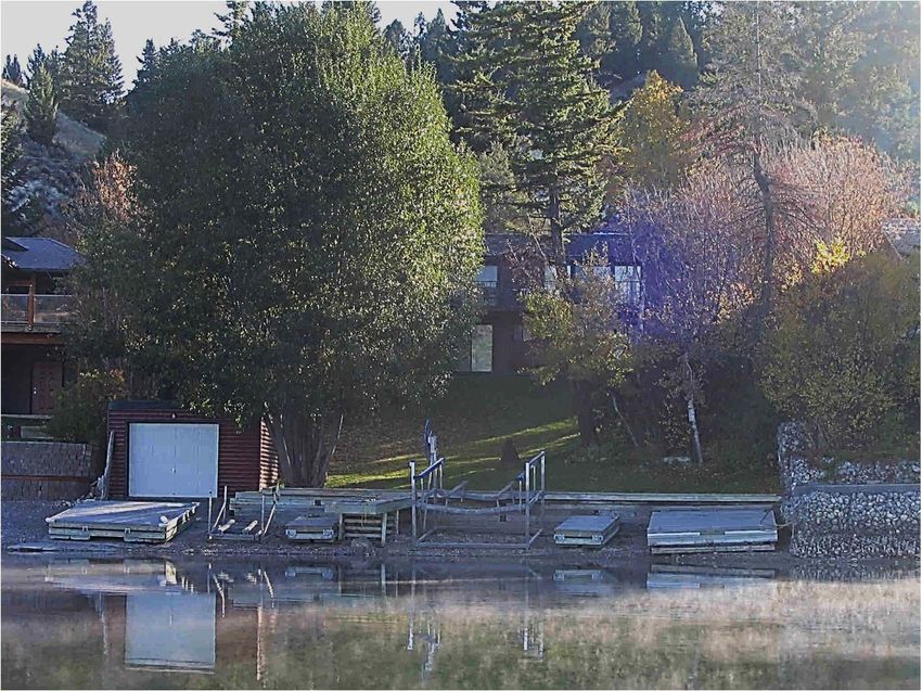
Windermere Lake FIMP
ACKNOWLEDGEMENTS
We are grateful for project management and draft review contributions provided
by Living Lakes Canada, Ryan Cloutier (Acting Manager) and Bruce MacDonald
(Project Director). Further, we appreciate the technical review provided by the
above and other members of the Foreshore Inventory and Mapping Technical
Committee:
Bruce MacDonald, B.Sc., B.Ed., FIMP Program Director, Terra Limnic
Consulting.
Ryan Cloutier, M.Sc., R.P.Bio., Acting Program Manager.
Heather Leschied, B.E.S. (Hons), FIMP Program Manager, Living Lakes
Canada.
Jason Schleppe, M.Sc., R.P.Bio., President, Ecoscape Envirn. Consultants
Ltd.
Teri Ridley, Senior Integrated Planning Biologist, DFO.
Brad Mason, Geospatial Analyst, BC Community Mapping Network.
Louise Porto, M.Sc., R.P.Bio., Wood Canada Ltd.
Peter Holmes, BSc., Wildlife Biologist (retired), FLNRORD.
Sherri McPherson, B.Sc., R.P.Bio., Aquatic Biologist, Lotic Envirn.
Consulting Ltd.
Kristen Murphy, Habitat Biologist, FLNRORD.
Andrea Evans (and temporarily Julia Podealuk, RFT), Authorization
Specialist, FLNRORD.
David De Rosa, B.Sc., P.Ag., Wildlife Biologist, Okanagan Nation Alliance.
The Shuswap Indian Band provided Traditional Ecological Knowledge and field
support (Basil Stevens and Braydi Rice). Brad Mason, BC Community Mapping
Network, also provided field support and technical expertise during the video
collection activity.
This project was funded by Department of Fisheries and Oceans (DFO) Canada
Nature Fund for Aquatic Species at Risk Program. Other funding contributors
include:
Real Estate Foundation of BC
Columbia Basin Trust
Lake Windermere Ambassadors
Fish and Wildlife Compensation Program
i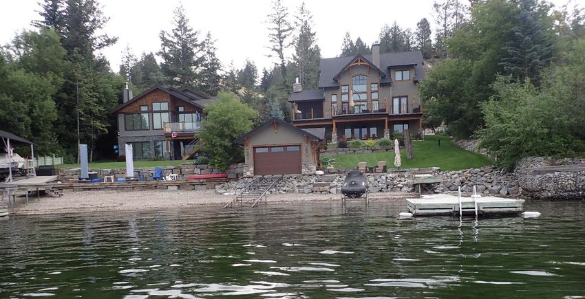
Windermere Lake FIMP

LIVING LAKES CANADA MISSION STATEMENT
     Living Lakes Canada is a non-profit society that facilitates collaboration in
     education, monitoring, restoration and policy development initiatives for the
     long-term protection of Canada’s lakes, rivers, wetlands and watersheds. Our
     mandate is to help Canadians understand, adapt and mitigate the impacts of
     climate change to water quality and quantity, biodiversity and healthy human
     communities through grassroots water stewardship activities. Living Lakes
     Canada bridges the gap between science and action to foster and normalize
     citizen- based water stewardship.

SUGGESTED CITATION
     Schleppe, J.1, and S. McPherson2. 2021. Windermere Lake Foreshore Integrated
     Management Planning. Prepared for Living Lakes Canada. Prepared by: Ecoscape
     Environmental Consultants Ltd.1, and Lotic Environmental Ltd.2

     Geographical Information Systems (GIS) mapping and data analyses were prepared
     by:

     Robert Wagner, B.Sc. (Ecoscape).
     Luke Crevier, M.Sc. candidate, (Ecoscape)

                                            ii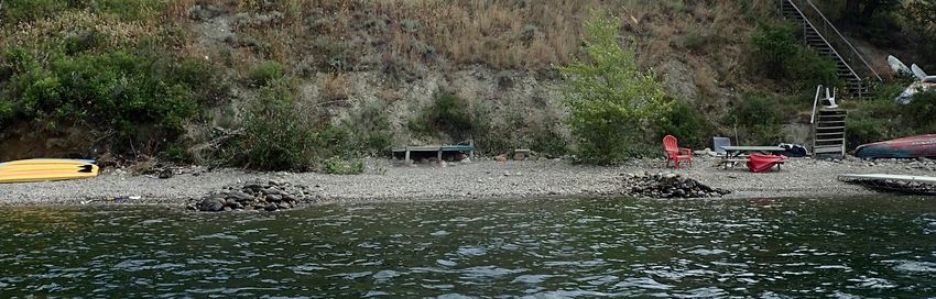
Windermere Lake FIMP

LIMITATIONS AND LIABILITY
This report in its entirety was prepared for the exclusive use of Living Lakes Canada and project
partners. Any use of this report by a third party, or any reliance on or decisions made based on
it, is the sole responsibility of the third party. The report authors disclaim responsibility of
consequential financial effects of any kind, or for requirements for follow-up actions or costs.

In preparing this report, the authors have relied in good faith on data and research provided by
others as noted. We assume that the information provided by others is factual and accurate.
The authors accept no responsibility for any errors, deficiencies, omissions, misstatements,
inaccuracies, or misinterpretations in the cited materials.

The services performed and described in this report were conducted in accordance with the
level of care and skill normally exercised by science professionals, subject to the same time,
financial and physical constraints applicable to the services. This report includes data gathered
during the investigations and the authors’ professional judgement considering those
investigations at the time of the report writing. No warranty is expressed, implied or made as
to the report conclusions, nor does this report provide a legal opinion regarding compliance
with applicable laws.

The results contained in this report are based upon data collected during a single season
inventory. Biological and lake systems respond differently both in space and time. For this
reason, the assumptions contained within the text are based upon field results, previously
published material on the subject, and air photo interpretation. The material in this report
attempts to account for some of the variability between years and in space by using safe
assumptions and a conservative approach. Data in this assessment was not analyzed
statistically and no inferences about statistical significance are made if the word significant is
used. Use of or reliance upon biological conclusions made in this report are the responsibility
of the party using the information. Neither the authors of this report (Ecoscape Environmental
Consultants Ltd. or Lotic Environmental Ltd.), or Living Lakes Canada (or project partners) are
liable for accidental mistakes, omissions, or errors made in preparation of this report because
best attempts were made to verify the accuracy and completeness of data collected, analyzed,
and presented.

Electronic media versions of any report are susceptible to unauthorized modification;
therefore, the signed final paper copies of this report shall be taken as the correct versions in
case of discrepancy.

                                                  iii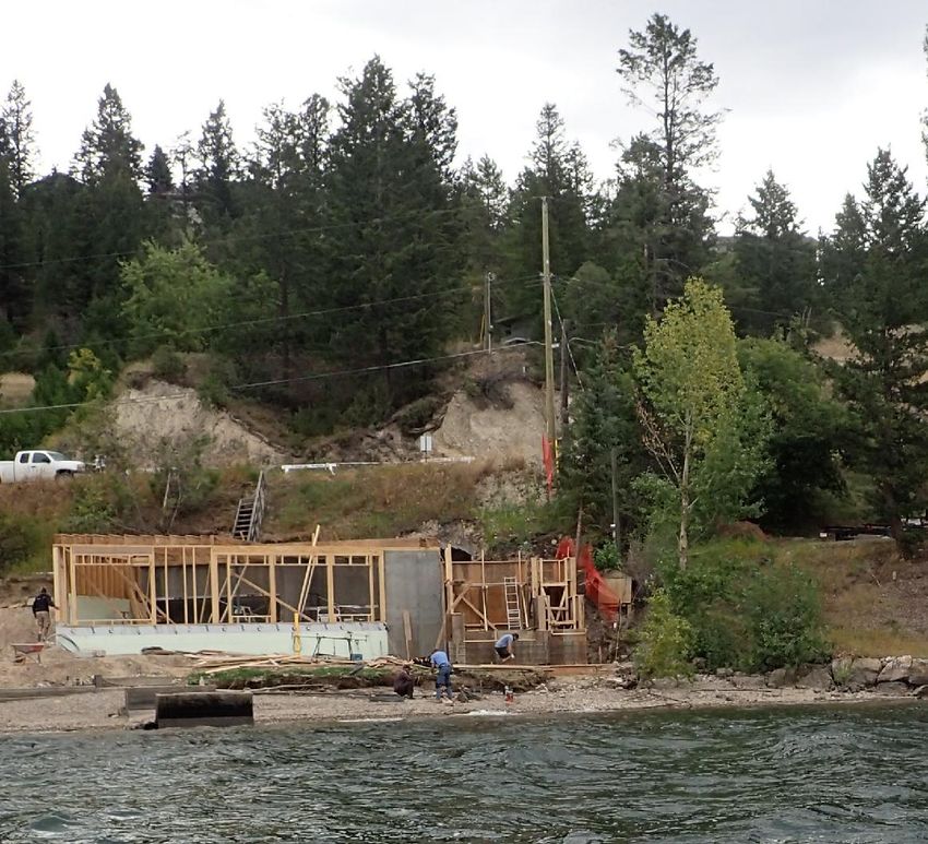
Windermere Lake FIMP

EXECUTIVE SUMMARY
    Living Lakes Canada (LLC) is part of a global network that facilitates collaboration
    in education, monitoring, restoration and policy development initiatives for the
    long-term protection of Canada’s lakes, rivers, wetlands and watersheds. Declines
    in lakeshore conditions are occurring globally, and LLC funded this shoreline
    mapping project through DFO’s Canada Nature Fund for Aquatic Species at Risk
    Program to help aid better long-term lakeshore planning in the Kootenay region of
    British Columbia (BC).
    The desire to live and recreate in the Kootenay Region of BC, combined with the
    generally positive economic climate, has resulted in rapid population growth and
    urban development. This growth has increased the value of most property, and in
    particular waterfront property for full time residency or seasonally for recreational
    purposes. As a result, commercial and residential development pressures have
    increased along lake foreshores, with a greater number of resorts, condominium
    complexes, and single-family homes proposed and built. Coupled with this, a
    general increase in affluence among a larger population, has put further pressures
    on lakefront habitats.
    Windermere Lake is located in the southern interior of BC in the Rocky Mountain
    Trench. The lake is located near the Columbia River headwaters. The two largest
    communities are the District of Invermere and the community of Windermere.
    Windermere Lake has seen a high demand for secondary recreational and
    investment properties. These developments inevitably impact the natural foreshore
    environment through removal of riparian and aquatic vegetation, and installation
    of modifications such as marinas, groynes, retaining walls, and docks.
    Unfortunately, these impacts can diminish the natural values that draw people to
    live and recreate along the foreshore in the first place. Ultimately, the goal is to
    maintain a balance between anthropogenic and natural values to the benefit of all
    residents and species that rely upon the lake.
    Foreshore Integrated Management Planning (FIMP) is a framework intended to
    help governments, landowners, and nonprofit organizations understand lake
    foreshore habitat values and the potential ecological risks from proposed shore
    altering activities. The resulting information is used to help make decisions
    regarding foreshore development and conservation. The methods used are
    standardized to provide a consistent framework for assessing proposed shoreline
    development. One of the many benefits of the standardized process is that if data
    from previous surveys are available, the rate of loss of natural shoreline can be
    determined. Understanding the rate of loss is important to better manage natural
    resource values along the foreshore (or shoreline). The FIMP methods have been
    developed to provide a habitat overview for all stakeholders, recognizing that the
    budgets available are finite. These data are primarily intended to aid land use
    planning, and they may not identify site specific habitats of importance. Detailed
    assessments and planning are an integral part of the urban development process
    and must be incorporated at later phases of project planning, as necessitated by any
    existing legislation or permitting processes required.

                                            iv
Windermere Lake FIMP

The key objective of this study was to update the original FIMP that was conducted
in 2006 on Lake Windermere and to document changes that have occurred over the
14-year period since the last survey. The following three standard FIMP steps were
completed during this study (Schleppe et al. 2020):
   1. Foreshore Inventory and Mapping (FIM) was the first step conducted and
      involved the collection of standardized field data from a boat viewing the
      shoreline. These data were supplemented with other available ecological
      datasets originating from a variety of sources (e.g., Species at Risk
      Management Plans, BC Conservation Data Center, Official Community Plans,
      etc.). The foreshore was defined as the area from the deeper edge of the
      littoral region of the lake (i.e., where the start of pelagic region begins) to an
      area up to 50 m past the high water mark (HWM) into the upland/riparian
      zone. Within this area, field technicians counted, catalogued and described
      the following: land use (e.g., residential development), modifications (e.g.,
      retaining walls, docks, marinas), and biophysical attributes (e.g., shoreline
      vegetation cover, substrates, large woody debris, and aquatic vegetation).
   2. Shoreline habitat sensitivities were determined using a ranking index called
      the Foreshore Habitat Sensitivity Index (FHSI). The index uses the FIM and
      other data to rank shoreline value in a cost effective method to approximate
      shoreline habitat values for fish, wildlife and ecosystems, based on field
      surveys and other existing information available (including assessments,
      inventories and professional opinions). The index is intended to act as a
      “flagging” tool to identify areas of the greatest ecological sensitivity to
      change from urbanization. As part of the FHSI, the most sensitive habitats
      were identified as Zones of Sensitivity (ZOS).
   3. The Foreshore Development Guide (FDG) was prepared to identify risks
      posed by different shore altering activities, to inform land use decisions. The
      FDG is intended to help mitigate or reduce the potential for negative effects
      to sensitive habitats owing to urban developments and identify areas for
      conservation (e.g., ZOS).
Overall, the FIM identified that 43% (16,191 m) of the shoreline was in a natural
condition, while the remaining 57% (21,208 m) was considered disturbed. The
natural areas were mostly present along undeveloped Indian Reserve lands at the
south east end of the lake, while the area with greatest disturbance occurred within
the District of Invermere. Since 2006, the percentage of disturbed shoreline
increased by approximately 1% across the entire lake shoreline, representing a loss
of approximately 369 m of natural habitat. The observed changes occurred through
incremental losses at a small scale, often associated with clearing of small natural
areas on private property. While these changes individually may not seem
significant, continued losses would add up over time, with the potential to result in
landscape-level changes to the surrounding ecosystem.

                                         v
Windermere Lake FIMP

The FHSI identified numerous important and high value areas around Windermere
Lake. Most of the criteria from the original study were included. However, a higher
level of detail went into defining and evaluating shoreline segments in this update.
Nine ZOS were identified, and these were habitats supporting: fish (Kokanee
spawning, native mussels, Burbot spawning/rearing), wildlife (avian bank nesting),
waterfowl (aquatic vegetation nesting, and migration corridors), and ecosystems
(grasslands, wildlife connectivity, and wetlands).
The FHSI identified that 30% of the foreshore habitat on Windermere Lake had a
Very High Ecological Rank, and 23% of the shoreline had a High Rank, which
translated to approximately 11,270 m and 8,751m of shoreline respectively. These
areas were represented predominantly by wetlands along the shore, stream
confluences, and locations where important habitat features such as spawning or
waterfowl migration were identified.
Moderate ranked habitat accounted for 30% or 11,261 m of the shoreline. Moderate
value segments occurred in locations that had fewer overlapping ZOS’s or were
areas with important ZOS that were impacted by development. These areas were
represented by all shore types and were more prevalent in areas of multi family,
single family, or urban parkland developments.
Areas or Low and Very Low Ecological Rank occurred along 17% (or 6,118m) of
shoreline. These areas occurred predominantly where there was increased
development intensity, such as multi family areas. This was expected, as areas with
more intense development often lose many of the habitat values that were
originally present. This highlights the importance of protecting natural areas in any
development process. Overall, habitat value has decreased over time in these areas,
and many developments did not appear to be planned in a way to avoid potential
impacts to fish and wildlife.
Recommendations have been presented to help all levels of government utilize
these findings and move towards more sustainable urban development practices.
Recommendations were categorized by type, and include measures to address
cumulative impacts, restoration, and other planning related needs. The FDG is
presented under separate cover and presents recommendations and tools to aid in
identification and planning so high value environments and ZOS are conserved
during development.

                                        vi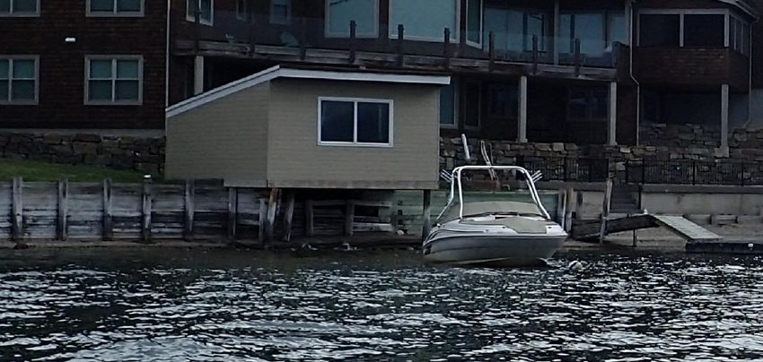
Windermere Lake FIMP

ACRONYMS

                           Pre 2020
     Post 2020 FIMP     FIMHP Methods
                                                            Acronym
     Methods Update     Update (only if
                           changed)
           CDC                            Conservation Data Center
           DFO                            Fisheries and Oceans Canada
           CMN                            Community Mapping Network
                                          East Kootenay Integrated Lake Management
        EKILMP
                                          Partnership
                                          Foreshore Development Guide / Shoreline
           FDG               SMG
                                          Management Guidelines Documents
                                          Foreshore Habitat Sensitivity Index / Aquatic
           FHSI              AHI
                                          Habitat Index
     FHSI Category                        Foreshore Habitat Sensitivity Index Category
     FHSI Criteria or
                                          Foreshore Habitat Sensitivity Index Criteria
       Criterion
     FHSI Ecological                      Foreshore     Habitat    Sensitivity    Index
          Rank                            Ecological Rank or output
          FIM                             Foreshore Inventory and Mapping
                                          Foreshore Integrated Management Planning
           FIMP             SHIM
                                          / Sensitive Habitat Inventory and Mapping
                                          Provincial Ministry of Forests, Lands, Natural
       FNLRORD                            Resource      Operations        and     Rural
                                          Development'
            GIS                           Geographic Information Systems
            GPS                           Geographic Positioning System
           HWM                            High Water Mark
            LLC                           Living Lakes Canada
           TEK                            Traditional Ecological Knowledge
            ZOS                           Zone of Sensitivity

                                          vii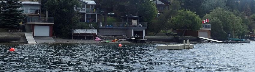
Windermere Lake FIMP

                                                       TABLE OF CONTENTS
ACKNOWLEDGEMENTS ......................................................................................................... I
SUGGESTED CITATION ......................................................................................................... II
LIMITATIONS AND LIABILITY ............................................................................................ III
EXECUTIVE SUMMARY ....................................................................................................... IV
ACRONYMS                      ................................................................................................................
                              ........................................................................................................... VII

1.0      INTRODUCTION.......................................................................................................... 1
               Study Area 1
               Foreshore Significance and Development Pressures .................................. 2
               Foreshore Integrated Management Planning Framework .......................... 3
               FIMP Value During Regulatory Reviews ...................................................... 3
               Original Windermere Lake Foreshore Assessment ..................................... 6
               Objectives 7
2.0      METHODS    8
               Foreshore Inventory and Mapping (FIM) Methods ..................................... 9
               Step 1 Pre-Field Assessment ........................................................................ 9
               Step 2 Field Assessment ............................................................................. 10
               Step 3 Video Documentation ...................................................................... 12
               Step 4 Reporting and Data Analysis ........................................................... 13
               Foreshore Habitat Sensitivity Index (FHSI) ............................................... 14
               Step 1 Preliminary Review of Original 2006 FHSI ..................................... 14
               Step 2 FHSI Criteria and ZOS development ............................................... 15
               Step 3 FHSI Calibration .............................................................................. 16
               Step 3 Reporting, Data Analysis and map production ............................... 17
               Foreshore Development Guide (FDG)........................................................ 18
               Traditional Ecological Knowledge (TEK)................................................... 18
3.0      FORESHORE INVENTORY AND MAPPING RESULTS ............................................. 19
               Summary of Shoreline Disturbance ........................................................... 19
               Summary of Land Use Disturbances .......................................................... 21
               Summary of Disturbance along Different Shore Types ............................. 27
               Summary of Anthropogenic Modifications ................................................ 31
4.0      FORESHORE HABITAT SUITABILITY INDEX RESULTS ........................................ 35
               FHSI Criteria Development ........................................................................ 35
               Fish Overview ............................................................................................. 36
               Wildlife and Ecosystems Overview ............................................................ 38
               Comparison to the original Zones of Sensitivity ........................................ 39
               Summary of FHSI Calibration ..................................................................... 45
               Summary of FHSI Shoreline Rankings ....................................................... 49

                                                                     viii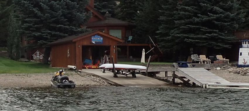
Windermere Lake FIMP

5.0    CONCLUSIONS AND RECOMMENDATIONS ............................................................ 53
             Land Use Policy and Lakeshore Planning .................................................. 53
             All Levels of Government ........................................................................... 53
             Local Government ...................................................................................... 54
             Provincial Government .............................................................................. 55
             Federal Government................................................................................... 56
             Addressing Cumulative Impacts ................................................................ 56
             All potential levels of Government............................................................. 56
             Provincial Government .............................................................................. 59
             Federal Government................................................................................... 60
             Restoration 60
             All levels of government ............................................................................. 60
             Local Government ...................................................................................... 61
             Provincial .................................................................................................... 61
             Education 62
6.0    REFERENCES ............................................................................................................ 63

                                                                 TABLES
Table 1:          Summary of Lake Windermere Characteristics (Urban Systems 2001). .................1
Table 2.          Summary of governing agencies for Windermere Lake shoreline. .........................4
Table 3.          Foreshore land uses and percent natural in 2006 and 2020................................22
Table 4.          Shore type and percent natural in 2006 and 2020.............................................. 28
Table 5.          Snorkel survey results from 18 sites along the Windermere Lake shoreline in 2007
                  (McPherson and Hlushak 2008 ) .......................................................................37
Table 6.          Species at Risk Occurrences for Windermere Lake (BC CDC 2021)...................... 39
Table 7.          Comparison of Current 2020 and Past 2006 ZOS, and areas that contributed to the
                  FDG. ................................................................................................................40
Table 8.          Summary of FIM, ZOS and modification criteria and rationale for inclusion in the
                  FHSI. ............................................................................................................... 41
Table 9.          Summary of criterion and method of incorporation into the FHSI. ......................47

                                                                FIGURES
Figure 1.         Summary of lake wide shoreline disturbance ....................................................21
Figure 2.         Example of incremental riparian loss from 2006 (top) to 2020 (bottom) ............ 23
Figure 3.         Example of new construction where little riparian enhancement is possible or
                  where works were occurring below the HWM. ..................................................24
Figure 4.         Shoreline disturbance in areas of single-family land use. .................................... 25
Figure 5.         Shoreline disturbance in areas of urban park land use. ......................................27
Figure 6.         Shoreline disturbance in areas of gravel beach shore type.................................. 29
Figure 7.         Shoreline disturbance in areas of stream mouth shore type................................31
Figure 8.         Total number of different shoreline modifications observed............................... 34
Figure 9.         Foreshore length (m) of disturbance. ................................................................35
Figure 10.        Overview of FHSI Habitat Rankings summarized as Percent of the Shore Length. 51
Figure 11.        Overview of FHSI Habitat Rankings for Windermere Lake..................................52

                                                                     ix
Windermere Lake FIMP
APPENDICES
Appendix A. Foreshore Inventory and Mapping GIS Map ............................................................... 68
Appendix B. FHSI and ZOS Maps ..................................................................................................................69
xWindermere Lake FIMP
1.0 INTRODUCTION
Living Lakes Canada (LLC) is part of a global network of over 120 non-governmental
organizations that facilitates collaboration in education, monitoring, restoration and
policy development initiatives for the long-term protection of Canada’s lakes, rivers,
wetlands and watersheds. LLC has a mandate to help Canadians understand, adapt, and
mitigate the impacts of climate change on water quality and quantity, biodiversity and
healthy human communities through grassroots water stewardship activities. LLC
helps bridge the gap between science and action to foster and normalize citizen- based
water stewardship. Declines in lakeshore conditions are occurring globally, and LLC
funded this shoreline mapping project through DFO’s Canada Nature Fund for Aquatic
Species at Risk Program to help aid better long term lakeshore planning in the Kootenay
region of British Columbia (BC).
LLC has contracted the team of Ecoscape Environmental Consultants Ltd. (Ecoscape)
and Lotic Environmental Ltd (Lotic Environmental) to complete Foreshore Integrated
Management Planning (FIMP), to update previous mapping completed on Windermere
Lake in the East Kootenay Region of British Columbia (BC) (the Project). The Project
involved using the recently revised FIMP methods (Schleppe et al. 2020).
Study Area
Windermere Lake is located in the southern interior of BC, in the Rocky Mountain
Trench. The lake is located near the Columbia River headwaters and is simply a
widening of the Columbia River rather than a ‘true lake” (Urban Systems 2001). Key
physical characteristics for the lake are summarized in Table 1. The two largest nearby
communities are the District of Invermere and the community of Windermere, located
at the north end and mid-east ends of the lake, respectively.
Table 1: Summary of Lake Windermere Characteristics
(Urban Systems 2001).
Parameter Value
Volume 55.19x10⁶ m3
Surface area 1610 ha
Littoral Area 1530 ha
Drainage 1340 km2
Maximum Depth 6.4 m
Mean Depth 3.4 m
Length 17.7 km
Average Width 1.1 km
1Windermere Lake FIMP
Foreshore Significance and Development Pressures
The desire to live and recreate in the Kootenay region of BC, combined with the
generally positive economic climate in BC and Alberta, has resulted in rapid population
growth and development. This growth has increased the value of all property, and in
particular waterfront property for recreational or permanent residences. As a result,
commercial and residential development pressures have increased along lake
foreshores, with a greater number of resorts, condominium complexes, and single-
family homes proposed and built. At Windermere Lake specifically, there has been a
high demand for secondary recreational and investment properties. These
developments inevitably impact the natural foreshore (or shoreline) environment
through removal of riparian and aquatic vegetation, and construction of modifications
such as marinas, groynes, retaining walls, and docks. Unfortunately, these impacts can
diminish the natural values that draw people to live and recreate along the foreshore
in the first place. Ultimately, the goal is to maintain a balance between anthropogenic
and natural values to the benefit of all residents and species that rely upon the lake.
The foreshore is ecologically significant because it is the transitional ecological
community between aquatic and terrestrial habitats. It provides a high diversity of
habitat for fish and wildlife and provides many beneficial ecological functions.
Shoreline habitats include aquatic vegetation, deep and shallow lake edges, stream
mouths, wetlands, riparian vegetation, grasslands. Ecological functions in these
habitats include but are not limited to providing forage, nesting and rearing areas for
aquatic and terrestrial fauna; buffering the watercourse from contaminants; and
maintaining bank stability (e.g., DFO 1992). Even though there are several legislative
mechanisms in place to help protect the foreshore (e.g., Federal Fisheries Act, Local
Government Official Community Plans, etc.), anthropogenic pressures often result in
both small and large incremental losses leading to habitat fragmentation and
degradation. These impacts reduce the ability of a lake to provide habitat necessary for
fish, wildlife, and ecosystems to sustain populations.
As a result of the ongoing urban development pressures and evidence of degradation,
Foreshore Inventory and Mapping1 (FIM) was implemented in BC, starting in 2004 by
the Community Mapping Network and Regional District Central Okanagan (see
Schleppe et al. (2019) for summary of methodological development). In 2020, the
methods were updated, and the assessment framework was renamed Foreshore
Integrated Management Planning or “FIMP”. Although the name has changed, the
primary objective of the FIMP process remains to identify environmental values of
importance and provide land-use planning guidelines to reduce impacts on high value
1
Foreshore Inventory and Mapping and the Aquatic Habitat Index (AHI) were commonly referred to
as Sensitive Habitat Inventory and Mapping or SHIM in the Kootenays. While these projects are
commonly referred to as SHIM, they should not be interchanged with Sensitive Habitat Inventory and
Mapping projects that are undertaken on small streams. While names are often used
interchangeably, this document will rely upon and utilize the new accepted terms and definitions as
required, despite the common use of the word SHIM.
2Windermere Lake FIMP
areas. The science-based methods were developed with input from all levels of
government (Federal, Provincial, regional, and municipal), First Nations, lake
stewardship groups and professional consultants. As a result, the outputs including
those specific to Windermere Lake have received support from these groups and have
been relied upon during development planning.
Foreshore Integrated Management Planning Framework
FIMP is intended to help governments, landowners, and nonprofit organizations
understand lake foreshore habitat values and the potential ecological risks from
proposed shore altering activities (Schleppe et al. 2020). The outputs are used to help
make decisions regarding foreshore development and conservation. The methods are
standardized to provide a consistent framework for shoreline development reviews.
One of the many benefits of the standardized process is that if data from previous
surveys are available, the rate of loss of natural shoreline can be determined.
Understanding rates of loss is important to better manage the shoreline. The methods
have been developed to provide an overview of ecological values of the shoreline,
recognizing that budgets available are usually finite. These data and analytical results
are primarily intended to aid land use planning, and they may not identify site specific
habitats of importance. Detailed assessments and planning are integral for individual
developments planned and must be incorporated as necessitated by regulatory
requirements, conservation strategies, etc.
The FIMP process follows three general steps (Schleppe et al. 2020):
1. Shoreline inventory and mapping is conducted following the Foreshore
Inventory and Mapping (FIM) protocols. FIM consists of collection of
standardized field data which is supplemented with the inclusion of available
ecological datasets originating for a variety of sources (e.g., Species at Risk
Management Plans, Official Community Plans, etc.).
2. Shoreline habitat sensitivities are determined using a ranking index called the
Foreshore Habitat Sensitivity Index (FHSI). The index is a simple, cost effective
method to approximate shoreline values collected from numerous datasets and
is developed using assessments, inventories and professional opinions. The
index is intended to act as a “flagging” tool to identify areas of greatest
sensitivity to change from urbanization. The index was formerly called the
Aquatic Habitat Index (AHI).
3. The Foreshore Development Guide (FDG) is prepared to identify risks posed by
different shore altering activities, to inform land use decisions. The FDG is
intended to help mitigate or reduce the potential for negative effects to sensitive
habitats owing to urban developments.
FIMP Value During Regulatory Reviews
Windermere Lake is managed by numerous local, regional, Provincial, and Federal
agencies. Each governing agency acts as the approving authority for different land use
activities that may impact the shoreline. For instance, local and regional agencies and
3Windermere Lake FIMP
First Nations generally approve land use activities on properties within their
boundaries. The Province manages all areas in and around lake (or stream) side water
bodies. The Federal government is responsible for managing fish and their habitats,
species at risk, and navigation.
Table 2. Summary of governing agencies for Windermere Lake shoreline.
Level Agency Applicable Legislation
Official Community Plan and
Local District of Invermere
associated Bylaws
Regional District of East Official Community Plan and
Regional associated Bylaws
Kootenay
Ministry of Forests, Lands,
Natural Resource Operations Water Sustainability Act,
Provincial and Rural Development & Streamside Protection Act,
Ministry of Environment and BC Parks
Climate Change Strategy
Federal Fisheries Act, Species
Department of Fisheries and
Federal At Risk Act,
Oceans (DFO) Navigation Protection Act
Ktunaxa Nation and Shuswap Official Community Plan and
First Nation
Indian Band associated Bylaws and/or
Foreshore development and other related undertakings are governed by several
federal, provincial, regional and municipal regulatory requirements (e.g., acts,
regulations, bylaws and policies). The FDG provides regulators with a clear, consistent,
and coordinated management strategy to protect shoreline environmental values,
which can be used during the development review process. Key regulatory
requirements triggered by foreshore development and undertakings are summarized
below, while a full listing of other potential requirements is provided in the FDG
(Schleppe and Mcpherson 2021). Despite current and historic regulatory requirements,
there are still documented impacts resulting from shoreline urbanization, inferring that
more stringent requirements to maintain ecological values are required.
For projects near fish bearing waterbodies, the Federal Fisheries Act requires Project
Reviews to ensure works or undertaking adjacent to or within watercourses do not
result in the harmful alteration, disruption or destruction of fish habitat (HADD). Where
a HADD is necessary, an Authorization from DFO is required that clearly demonstrates
that Avoidance, Mitigation and appropriate Compensation or Offsetting measures are
in place.
In BC, the foreshore is defined as the land between the high and low water mark. This
area is considered Crown Land (in almost all cases, with a few rare exceptions) and
includes the permanently wetted lake area (Province of BC 2021a). Crown Land falls
under provincial jurisdiction, and the public retains the right to access it even if the
4Windermere Lake FIMP
upland is privately owned. Provincial authorization is required for any developments
(e.g., installation of docks or retaining walls below, at, or near the high water mark
[HWM]) on Crown Land. This includes but is not limited to obtaining BC Lands Act
leases/licenses to occupy the land and / or obtaining BC Water Sustainability Act
Approval or Notification for Works in and About A Stream. The BC Lands Act also
governs private land, where upland property ownership abuts the Natural Boundary
or more commonly the Present Natural Boundary (PNB). The Land Act defines PNB as:
“The visible high water mark of any lake, river, stream or other body of water where
the presence and action of the water are so common and usual, and so long
continued in all ordinary years, as to mark on the soil of the bed of the body of
water a character distinct from that of its banks, in vegetation, as well as in the
nature of the soil itself.”
First Nation referrals are part of the environmental application review process, with
environmental protection usually being a very important component of their review.
Consequently, various First Nations have also reported using the FIMP reports to
support their review of proposed projects. This includes the Ktunaxa Nation Council for
Windermere Lake development application referrals.
Local governments around Windermere Lake have authority to make local land use
decisions, typically governed through bylaws, policies and a Official Community Plans
(OCP). Most of Windermere Lake is within the jurisdiction of the Regional District of
East Kootenay (RDEK), with development governed by the Windermere Official
Community Plan (OCP; RDEK 2019). Under the current OCP, all areas designated as
“Red” or “Orange” zones in the original Shoreline Management Guidelines (East
Kootenay Integrated Lake Management Partnership [EKILMP] et al. 2009) are within a
Development Permit Area (DPA). These “Red” areas were previously identified as a Key
Habitat Area (essentially synonymous with ZOS – see next section) that overlapped
with Very High and High value shoreline areas, and “Orange” areas were areas with ZOS
alone. The DPA extends 30 m into the lake from the natural boundary. The intent of the
DPA is (RDEK 2019):
To ensure that activities within and along the shoreline are undertaken in a
manner that minimizes the disruption or alteration of the natural ecosystems
that creates fish and wildlife habitat and maximizes the opportunity for
restoration and enhancement. The intent is not to preclude all development in
DPAs, but to provide notice that these portions of the shoreline provide unique
characteristics that warrant special review and consideration, and to ensure
appropriate mitigation or protection measures are prescribed where identified
by a Qualified Environmental Professional (QEP).
The District of Invermere OCP has categorized the foreshore into four water zones: 1)
Residential, 2) Group Moorage, 3) Institutional, and 4) Commercial (District of
Invermere 2002). Each zone has permitted uses with docks, swimming platforms,
mooring buoys, launch ramps, moorage and boat lifts essentially acceptable in all zones.
The commercial zone also allows for marinas. In each zone district regulations are
specified for these structures (e.g., size, number per parcel, minimal distances from
5Windermere Lake FIMP
property line and other structures etc). Generally, environmental protection in the
municipality defers to the federal and provincial governments.
Original Windermere Lake Foreshore Assessment
Sensitive Habitat Inventory and Mapping (SHIM) was previously completed at
Windermere Lake using and early version of the FIM database and a study on Okanagan
Lake that developed the concept of a shoreline habitat index (Schleppe and Arsenault
2006). The original Windermere study was prepared in three reports: Foreshore
Inventory and Mapping (FIM; McPherson and Michel 2007), Fish and Wildlife
Assessment (McPherson and Hlushak 2008), and Shoreline Management Guidelines
(EKILMP et al. 2009). Key findings from these original shoreline studies are
summarized here.
The FIM identified that railway, residential, private recreational, parks and commercial
uses impacted over half of the foreshore (McPherson and Michel 2007). Anthropogenic
alterations in these areas included riparian vegetation removal and foreshore
modifications (including retaining walls, docks, groynes, boat houses, marinas and
boat launches). Retaining walls were prevalent along substantial portions of the
residential and private recreational areas, with nearly half built below the HWM. A
historical air photo analysis revealed that by 1968 approximately 61% of the shoreline
had been disturbed, and by 1995 an additional 13% of the shoreline was disturbed,
with disturbance including any human induced modification, structure or alteration.
The fish and wildlife assessment report provided insight to species usage along the
foreshore (McPherson and Hlushak 2008). The fish sampling program surveyed 18
shoreline sites in various habitats around the lake in both the summer and fall seasons.
The most abundant species were Redside Shiners (8 % of all catches) and Largemouth
Bass (5 %, a non-native species). Sport fish abundance was low and included Bull Trout
(0.06 %), Mountain Whitefish (1.2 %), and Kokanee (0.6 %). Burbot and Westslope
Cutthroat Trout were not observed. However, these sport fish were expected to use the
lake as a migration corridor to access spawning grounds.
The lake outlet downstream to Athalmer was identified as particularly important area
for fish because of the Kokanee spawning beds amongst other fisheries value present.
Historically, prior to establishment of dams downstream in the Columbia System,
Chinook Salmon also spawned in this location, and there is vision to see them return
again in the future. Given these values, the lake outlet was identified to be a culturally
significant area (e.g., by the Shuswap Indian Band). The outlet was formally classified
as an important archaeological area (referenced as Salmon beds Archaeological Site
EdQa 121), given its use as a campsite and food processing area for First Nations for
over the last 1000 years (Royal BC Museum 1999).
Wildlife surveys identified 57 species of birds, of which 54% were migratory species.
The highest diversity of birds was at sites with undisturbed vegetated habitat structure
(i.e., emergent aquatic vegetation, riparian vegetation, wetlands, native grasslands and
6Windermere Lake FIMP
forest). Wildlife trees were an additional ecologically important habitat noted at
several locations around the lake.
The fish and wildlife assessment divided the 35.6 km of shoreline into 26 segments.
Over half of the shoreline was found to be of Very High or High value. Highest value
habitat was in undeveloped areas, or where disturbances were set-back from the
shoreline. Residential areas tended to have the highest level of impact, reducing overall
habitat function and value. Specific ZOS identified were wetlands/riparian areas, creek
mouths, native grasslands, wildlife habitat (i.e., cliff bluff areas) and wildlife corridors,
gravel/cobble habitat (i.e., burbot habitat), biologically productive areas (i.e., mussel
beds), and unimpacted natural areas. Of these ZOS, all but gravel/cobble habitat and
wetlands/riparian were designated as Key Habitats Areas, which greatly influenced
the Shoreline Management Guidelines (EKILMP 2009).
In the Shoreline Management Guidelines, Key Habitat Areas were generally
recommended to be conserved. Very High and High ecological values shoreline areas
were identified to have development limited to low risk activities, and the remaining
areas of Moderate to Very Low ecological value were considered to be areas where
development would best be concentrated. An activity risk table identified development
activities that were both suitable and not suitable in these respective colour zones,
including if a species at risk was present or not. A decision-making flow chart was
provided, summarizing the regulatory review process for high and low risk projects.
Guideline development involved input from federal, provincial and local government;
First Nations; and non-government/stewardship groups. It was a testament that this
collaboration resulted in the guidelines being incorporated fully under the RDEK OCP.
Objectives
The key objective of this study is to update the original Windermere Lake FIMP
assessment (and related report) that was completed in 2006 to document any potential
changes that have might have occurred over this 14-year period. This update will be
used to assess the status of the foreshore, to compare changes in natural shoreline over
time, and to identify any trends that might need consideration into the future. The
resulting information will be considered a tool to help inform environmental reviews,
policies, and standards. It is hoped that these new data and reports can be incorporated
into local, regional, Provincial, and Federal policy and guidelines, where appropriate, to
promote evidence-based land use and planning decisions.
7Windermere Lake FIMP
In meeting this objective, the objectives of the original study (FIMP) will also be met
(McPherson and Hlushak 2008):
1. Provide an overview of foreshore habitat condition on the lake that will include
but be not limited to an inventory of biophysical values, land use,
anthropogenic alterations, and sensitive habitats.
2. Obtain a spatially accurate digital video of the shoreline, to be made available
through GIS.
3. Develop an accessible GIS database of the foreshore ecological values.
4. Collect information that will aid in prioritizing high value areas for protection.
5. Integrate information with upland development planning to help provide
broader ecosystem protection.
2.0 METHODS
For this Project, Windermere Lake was re-assessed using the recently revised FIMP
methods FIMP (Schleppe et al. 2020). The FIMP involved completing the three
components: FIM, FHSI, and FDG. Since the lake was previously assessed, past results
were included here to provide an understanding of any changes that have occurred
over the 14-year time period since the last assessment. To align the original data set
with the new standards with as much accuracy as possible, important and detailed
quality assurance/quality control (QA/QC) procedures were completed, such as photo
comparisons between the original survey and this survey wherever feasible. This
process is described below.
The Ecoscape/Lotic Environmental Project Team was carefully selected to include
professionals with direct experience conducting FIM, FHSI, and FDG on other similar
projects in the province (all team members), as well as on Windermere Lake (Sherri
McPherson). The team was comprised of:
Ecoscape
Jason Schleppe as Lead Biologist (M.Sc., R.P.Bio.)
Robert Wagner as the GIS Specialist (B.Sc.)
Scott McGill as a Project Biologist (B.Sc.)
Luke Crevier as a Data Analyst (M.Sc. candidate)
Lotic Environmental
Sherri McPherson as Lead Biologist (B.Sc. R.P.Bio.)
Tegan Arnett as Project Biologist (B.Sc., R.P.Bio.)
8Windermere Lake FIMP
Foreshore Inventory and Mapping (FIM) Methods
Foreshore Inventory and Mapping methods were used to delineate, inventory and map
foreshore habitats. The foreshore was defined as the area from the deeper edge of the
littoral region of the lake (i.e., where the start of pelagic region begins) to an area up to
50 m past beyond the HWM into the upland/riparian zone. Within this area, through
completion of the FIM, field technicians counted, catalogued and described the
following: land use (e.g., residential development), modifications (e.g., retaining walls,
docks, marinas), and biophysical attributes (e.g., shoreline vegetation cover, substrates,
large woody debris and aquatic vegetation). The FIM was completed in a four-step
process, as identified below:
Step 1 Pre-Field Assessment
The FIM field database was prepared by first converting the original database into the
revised database available in the new FIMP methods (Schleppe et al. 2020). This was
done by identifying data fields that were collected using similar methods in the original
FIM database and merging these with applicable data fields in the revised database.
Attribute data requiring additional field consideration to ensure consistency between
the former and current data collection were identified.
This original FIM geographical information system (GIS) dataset was converted using
GIS ‘R’ software to script a “rule set”. The following rules were applied:
1. Data fields attributes in the 2006 FIM database were matched with the most
similar field in the FIM 2020 database. The matched fields were then updated to
the most common nomenclature.
2. Fields that were not sampled during the original event were left as either NA’s
or were estimated using photos, aerial imagery, or other methods.
3. Field data notes in the original database were left in the comments field and / or
GIS meta-data, to allow users to understand what fields were added in the
second FIM and which fields were completed using estimation or other tools.
This field database was used for field inventory.
Important GIS mapping layers from the original FIM database that were to be updated
were identified and transferred to the field maps. These data were used to help identify
specific field data mapping requirements. Associated filed data mapping protocols
were developed (e.g., for FHSI or ZOS).
9Windermere Lake FIMP
Other background information was mapped, including the following data layers:
1. The Provincial and Federal GIS registries were searched for Species and
Ecological Communities at Risk and Critical Habitat data. A review was
conducted for other high value habitats potentially present (i.e., grasslands and
wildlife habitat areas). Mapped occurrences were loaded on to field maps.
2. Local government data was obtained, including zoning, cadastral (including
government and non-government organization [NGO] conservation areas),
Official Community Plan Development Permit areas, and any recent aerial
imagery. These data were used to help understand the key land use
designations, inform the field surveys (e.g., segment brakes), and inform
conservation recommendations.
3. The retaining wall and historical air photo GIS data presented in the original
assessment were obtained from the Regional District of East Kootenay and
incorporated as possible.
4. The Columbia River Wetlands have been the focus of extensive bird survey work
by stewardship groups. This included work through the Columbia Wetlands
Waterbird Survey (2015 - present), the Columbia Wetlands Marsh Bird
Monitoring Project (2016 - present), and the Columbia Valley Swallow Project
(2020 - present). We reached out to the coordinator (R. Darvill pers. comm) to
provide relevant data. Nesting locations for Bank Swallows, a threatened species
under the Species at Risk Act (SARA 2017), and other general bird use
information was provided.
The original segment breaks were reviewed for potential updates. The most recent
cadastral and land use data was used to verify land parcel information and help confirm
land use categories. From this office exercise, there were no significant land use
changes evident, inferring that there were no preliminary segment break changes
required.
Finally, all pertinent data were loaded onto the most recent aerial imagery, and these
were used as the field maps. All relevant spatial field data identified was also loaded
onto the iPad for reference.
Step 2 Field Assessment
The FIM field assessment was conducted by boat on August 19 – 22, 2020 using an 18
foot aluminum hulled vessel. A crew of five was aboard the boat throughout the
assessment: Jason Schleppe and Scott McGill (Ecoscape), Sherri McPherson and Tegan
Arnett (Lotic Environmental), and Basil Stevens (Shuswap Indian Band). Bruce
MacDonald (LLC) also joined for one the first day as an observer to complete various
method calibration exercises.
10Windermere Lake FIMP
The updated database was used for field collection of FIM data. During this step, field
data were collected as follows:
1. Using a laptop computer, data were entered electronically into the MS Excel FIM
database field forms. The field forms contained the original FIM data to allow
review and evaluation of both years simultaneously.
2. Biophysical and habitat attribute data were collected in accordance with the
FIMP methods. (Schleppe et al. 2020). All mandatory data were collected, as well
as other important but non-mandatory data (e.g., overhanging vegetation, large
woody debris, and modifications).
3. In addition to inputting counts and estimates of shoreline modifications in the
FIM database, select modifications were spatially mapped. IPads were used to
spatially mark collected data using ArcGIS collector. Retaining walls and erosion
control (riprap) were mapped as lines; while docks, groins, boat launches
(excluding those associated with boat houses) were mapped as points.
4. Fish, wildlife and ecological habitat surveys were conducted, with the results
mapped as polygons, lines, or points. This information was used to inform the
FHSI and ZOS analysis. This involved mapping the following:
a. Polygons: emergent vegetation (submergent, floating, and
emergent)/backwaters or wetlands, bank nesting habitat, approximate full
extent of mussel beds, spawning habitat (gravel beds), and
reptile/amphibian migration areas.
b. Points: overhanging vegetation, mussels, den/burrows, wildlife trees.
5. All mapping was done directly onto an iPad, which was then loaded in GIS and
spatially adjusted and proofed using photos and available aerial imagery.
6. In 2020, select attribute data were collected differently from the original SHIM.
These differences were as follows:
a. Retaining walls: retaining walls were mapped to allow for a comparison with
the retaining wall assessment provided in the original SHIM. However, only
the retaining walls in close proximity to the HWM were counted. Retaining
walls upslope were not included, nor were those that had no direct impact
on the foreshore (e.g., where mature trees were in front of wall that was
setback approximately 10 m from the HWM).
b. Boat launches: all boat launches, including private gravel launches leading
out of the boathouses were counted. The original SHIM only counted the
public launch sites. These launches were split into two categories based on
whether they were gravel or concrete and mapped using the iPad.
Sometimes large concrete slabs or similar were also counted. Although they
were not a “boat launch”, the quantity of concrete was similar in form and
function that this was deemed the most equivalent FIM attribute feature to
map the data as. For example, the photo below shows a concrete slab that
would be considered a boat launch, regardless of actual use.
11Windermere Lake FIMP
c. Boat rack/lifts: when two jet skis were connected, they were counted as one.
We mention this as it was not specified in the methods.
7. The original FIM segment breaks were confirmed and updated, where
necessary. Some segment breaks were updated by splitting the original segment
further or spatially adjusting them to the new approximate HWM digitized
during this mapping exercise. Segments were split to identify high value
habitats, typically embedded within a more urban area. In one instance, a new
segment was created for a small island that was previously mentioned in the
data but not mapped. Other examples were that some marina segments were
split out from adjacent areas with a different land use and different level of
disturbance. When a segment was split, the original end points were maintained
so that the neighboring segments would not be affected. This was important to
support the comparative analysis with the original FIM.
8. Geo-referenced still photographs were taken to characterize each shoreline
segment and its attributes. These photos, where possible, were spatially
referenced with the previous photos from 2006, and were used extensively to
QA/QC the 2006 data to ensure rates of change calculated were as accurate as
possible against 2020 data.
Step 3 Video Documentation
Video documentation was conducted to assist in classifying land use and features, and
to detect change over time. A shoreline video was collected on September 30, 2020,
from a boat by a crew of two (Scott McGill and Brad Mason). An 18 ft. commercial boat
was used. The weather conditions during the survey were dry, clear and calm, which
aided data collection.
The video was recorded within 50 m from the shoreline. The video was filmed using a
an ipad and was merged with a file for the “path taken” using GPS. Features of the
camera were: a lens shroud to protect from direct sunlight, a polarized lens, a tripod,
and hard drive storage media.
12Windermere Lake FIMP
Video processing involved running the video through an image stabilizer and applying
text to identify the segment number. The time, boat speed, geo-reference (latitude and
longitude coordinates), and compass direction (boat's travel direction) were also
shown on the video. The output was provided in MP4 format, to work with any standard
viewing software.
The following is a stepwise summary of video collection:
1. Created georeferenced maps showing segments, orthophoto, and landmarks to
allow the video field crew to determine location of Segment Breaks
2. Created a video for each segment to reduce file size, and to make finding a
location of interest easier (instead of scanning one large video).
3. Georeferenced maps were uploaded into iPads to allow the video field crew to
see their location on the map.
4. GPS tracks were recorded in sync with the video recording so the start/stop of
GPS track was recorded synonymous with the video start/stop.
5. All video and GPS tracks were downloaded post field work, and these were
processed on a computer at the office as follows:.
a. Video editing software was used to stabilize the video due to wave
action/boat movement.
b. Metrics were derived from the GPS track data including date, time, speed,
direction, and GPS coordinates.
c. The metrics were synchronized with the videos.
d. Metrics were graphically displayed on the exported video.
Step 4 Reporting and Data Analysis
The FIM database was first reviewed and corrected for QA/QC purposes. This involved:
1. Verifying that both the original and new FIM databases were copied over
properly. This step was done to ensure the estimates of change between the
assessments were accurate as possible.
2. Where segments were split, the original data were also split accordingly,
through a detailed review of the original photos and air photos. Field review was
also part of the process, where assessors considered whether structures or
features were “new” or not to aid in ensuring data consistency. For each FIM
database attribute, particularly the modifications, data were assigned based
upon the best estimate from the review. It is noted that perfection in
interpretation was difficult, and while all attempts for accuracy have been made,
errors may still occur resulting from many factors.
3. Air photo analysis was conducted to revise the approximate HWM of
Windermere Lake. Recent images and vegetation queues were used to
determine the approximate location. Data collected during the field surveys on
the iPads were also considered, to help identify the edge of emergent vegetation
for example. Results were mapped in GIS. The approximate HWM and location
of this line formed the basis for all FIM segments and subsequent analysis of
shore length. As a result, the original FIM spatial database was moved to this
13You can also read