Assessing the accuracy of remotely sensed fire datasets across the southwestern Mediterranean Basin
←
→
Page content transcription
If your browser does not render page correctly, please read the page content below

Nat. Hazards Earth Syst. Sci., 21, 73–86, 2021
https://doi.org/10.5194/nhess-21-73-2021
© Author(s) 2021. This work is distributed under
the Creative Commons Attribution 4.0 License.

Assessing the accuracy of remotely sensed fire datasets across the
southwestern Mediterranean Basin
Luiz Felipe Galizia1 , Thomas Curt1 , Renaud Barbero1 , and Marcos Rodrigues2,3
1 INRAE,   RECOVER, Aix-Marseille Univ., Aix-en-Provence, France
2 Department  of Agricultural and Forest Engineering, University of Lleida, Lleida, Spain
3 Joint Research Unit CTFC-AGROTECNIO, Solsona, Lleida, Spain

Correspondence: Luiz Felipe Galizia (luiz.galizia@inrae.fr)

Received: 10 July 2020 – Discussion started: 27 July 2020
Revised: 3 November 2020 – Accepted: 15 November 2020 – Published: 11 January 2021

Abstract. Recently, many remote-sensing datasets provid-           1   Introduction
ing features of individual fire events from gridded global
burned area products have been released. Although very             Vegetation fires are a common and destructive hazard in the
promising, these datasets still lack a quantitative estimate of    southwestern Mediterranean Basin. Over the past 4 decades,
their accuracy with respect to historical ground-based fire        there were, on average, 47 766 fires and 413 209 ha burned
datasets. Here, we compared three state-of-the-art remote-         annually in this region (San-Miguel-Ayanz et al., 2017) caus-
sensing datasets (RSDs; Fire Atlas, FRY, and GlobFire)             ing extensive economic and ecological losses and even hu-
with a harmonized ground-based dataset (GBD) compiled              man casualties (Keeley et al., 2011; Molina-Terrén et al.,
by fire agencies monitoring systems across the southwestern        2019). Fire is a complex phenomenon due to the confluence
Mediterranean Basin (2005–2015). We assessed the agree-            of several factors, including climate, weather, human activ-
ment between the RSDs and the GBD with respect to both             ities, and vegetation (Bowman et al., 2009). The Mediter-
burned area (BA) and number of fires (NF). RSDs and the            ranean fire regime is dominated by human-caused ignitions
GBD were aggregated at monthly and 0.25◦ resolutions,              (Ganteaume et al., 2013), with most of the total burned area
considering different individual fire size thresholds ranging      (BA) linked to a limited number of large fires during the
from 1 to 500 ha. Our results show that all datasets were          summer (Turco et al., 2016). These large fire events are
highly correlated in terms of monthly BA and NF, but RSDs          facilitated by dry conditions and high temperatures, which
severely underestimated both (by 38 % and 96 %, respec-            are both expected to increase in the future under climate
tively) when considering all fires > 1 ha. The agreement be-       change (Dupuy et al., 2020; Ruffault et al., 2020; Turco et
tween RSDs and the GBD was strongly dependent on indi-             al., 2018a). Additional factors such as landscape changes,
vidual fire size and strengthened when increasing the fire size    as well as changes in forest and fire management, may also
threshold, with fires > 100 ha denoting a higher correlation       shape future fire activity (Moreira et al., 2020; Pausas and
and much lower error (BA 10 %; NF 35 %). The agreement             Fernández-Muñoz, 2012). Projecting future changes in fire
was also higher during the warm season (May to October)            activity requires modeling efforts across broad geographi-
in particular across the regions with greater fire activity such   cal scales to better understand processes and mechanisms
as the northern Iberian Peninsula. The Fire Atlas displayed        conducive to fire ignition and spread. However, one of the
a slightly better performance with a lower relative error, al-     main limitations in fire modeling lies in the lack of reliable
though uncertainty in the gridded BA product largely out-          and homogeneous information on fire activity across space
paced uncertainties across the RSDs. Overall, our findings         (Hantson et al., 2016; Williams and Abatzoglou, 2016). This
suggest a reasonable agreement between RSDs and the GBD            is particularly true in Europe where the lack of data shar-
for fires larger than 100 ha, but care is needed when examin-      ing, as well as the lack of consistent quality-control proce-
ing smaller fires at regional scales.                              dures of national ground-based fire datasets, has hampered
                                                                   the analysis of fire regimes across broader regional or conti-

Published by Copernicus Publications on behalf of the European Geosciences Union.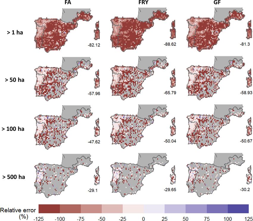
74                                                L. F. Galizia et al.: Assessing the accuracy of remotely sensed fire datasets

nental scales (Mouillot and Field, 2005; Turco et al., 2016).      compiled by regional agencies across the most active fire
To overcome this limitation, the European Forest Fire Infor-       region in Europe (i.e., southwestern Mediterranean Basin)
mation System (EFFIS; San-Miguel-Ayanz et al., 2015) is            during the common period of observations (2005 to 2015).
increasingly using remote-sensing techniques for monitoring        While most previous studies have evaluated remote-sensing
fire activity across Europe.                                       data on a fire-by-fire basis, this study aggregates individual
   In the last decade, remote sensing has contributed to fos-      fires across months and pixels (0.25◦ ) and seeks to estimate
tering fire-related products with spatial and temporal consis-     to what extent the temporal variability in both fire frequency
tency and global coverage (Chuvieco et al., 2019; Mouillot         and burned area are captured by remote-sensing datasets. We
et al., 2014). The MODIS sensor stands out as one of the           sought to provide a solid answer to the following questions.
best data providers for most burned area products such as          (i) Are remote-sensing datasets capturing the actual pattern
MCD64A1 (Giglio et al., 2018) and FireCCI50 (Chuvieco et           of fire occurrence and burned area? (ii) To what extent is their
al., 2018). In particular, the latest generation of BA products,   accuracy dependent on fire size? To answer these questions,
the MCD64A1v006, sets the basis for an exhaustive global           we examined the agreement between remotely sensed and
estimation of fire-related carbon emissions, which is com-         ground-based fire datasets aggregated at monthly and 0.25◦
piled in the GFED4 database (Giglio et al., 2013; Randerson        resolutions across a range of individual fire size thresholds (1
et al., 2015; van der Werf et al., 2017). Although BA prod-        to 500 ha). This study may inform end users about remote-
ucts typically offer information about the pixels that burned      sensing datasets’ ability to proxy actual fire activity but also
in a given day, they do not provide information such as start-     inform them of their limitations.
ing/ending dates or the final extent of individual fire events
(Mouillot et al., 2014). This limitation has hampered efforts
to distinguish fire regimes dominated by different fire sizes      2     Data and methods
as both small but frequent fires and large but rare fires may
                                                                   2.1    Ground-based fire data
contribute equally to total burned area.
   In this sense, global datasets of individual fires derived      The ground-based dataset (GBD) was built from multiple fire
from pixel-level BA information have recently emerged as an        agency sources, including fire records from Portugal, Spain,
important resource for the fire community in improving our         France, and Sardinia in Italy (Table 1). All these ground mon-
understanding of fire regimes (Andela et al., 2019b; Artés         itoring systems provide high-quality datasets that have been
et al., 2019; Laurent et al., 2018a). Unlike raw BA prod-          extensively used in previous studies across France (Curt et
ucts, remote-sensing datasets of individual fires provide in-      al., 2014), Portugal (Pereira et al., 2011), Sardinia (Salis et
formation beyond the BA, such as fire shape, daily rate of         al., 2013), and the Mediterranean basin (Rodrigues et al.,
spread, and the number of fires (NF). The Fire Atlas (Andela       2020; Turco et al., 2016). Although not free of errors, these
et al., 2019a, b), FRY (Laurent et al., 2018a, b), and GlobFire    datasets constitute the most accurate source of historical in-
(Artés et al., 2019; Artés Vivancos and San-Miguel-Ayanz,          formation about fires available across the region.
2018) represent the most recent individualized fire datasets.         We extracted the following information from each regional
These datasets were built from specific algorithms to recon-       dataset: the day of ignition, the fire size, and the location of
struct fire patches from MCD64A1 pixel-based BAs. In spite         each fire. To ensure consistency across regions and scales,
of using different methodologies and different assumptions,        we analyzed the overlapping recording period among the
these datasets share a common objective: to aggregate neigh-       datasets, i.e., 2005–2015. Small fires (< 1 ha) were discarded
boring burned pixels with sequential burn dates into individ-      to ensure the coherence of the analysis since these were not
ual fire patches.                                                  reported systematically by agencies over the studied period.
   Although very promising, remote-sensing datasets of in-         The harmonized dataset contained 95 561 fire records, in-
dividual fires have been sparingly compared to historical          cluding only events that required a firefighting response (i.e.,
ground-based fire databases that are generally thought to be       disregarding agricultural and prescribed fires) (see Fig. 1).
the most reliable source of data regarding fire occurrence and
fire extent (Moreira et al., 2011; Mouillot et al., 2014). Pre-    2.2    Remotely sensed fire data
vious studies indicated that a rigorous evaluation of satellite
data with ground-based data is needed (Turco et al., 2019).        We used the most recent global remote-sensing datasets
Most validation procedures of these remote-sensing datasets        (RSDs) of individual fires: Fire Atlas (Andela et al., 2019a,
were based on comparisons between different satellite prod-        b), FRY (Laurent et al., 2018a, b), and GlobFire (Artés et al.,
ucts (Andela et al., 2019b; Laurent et al., 2018a) with, how-      2019; Artés Vivancos and San-Miguel-Ayanz, 2018). These
ever, scarce attention paid to independent ground-based ob-        datasets provide the date and the spatial extent of individ-
servations (Artés et al., 2019).                                   ual fires from the pixel-based burned area MODIS product
   In this work, we compared for the first time the three most     MCD64A1 Collection 6 (Table 2). The combined Terra and
recent remote-sensing datasets of individual fires (Fire Atlas,    Aqua MCD64A1 is derived from the surface reflectance im-
FRY, and GlobFire) with quality-controlled fire databases          agery and active fire observations. It provides a global cover-

Nat. Hazards Earth Syst. Sci., 21, 73–86, 2021                                       https://doi.org/10.5194/nhess-21-73-2021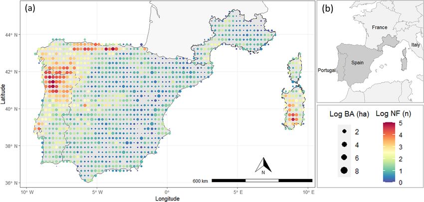
L. F. Galizia et al.: Assessing the accuracy of remotely sensed fire datasets                                                          75

Table 1. Fire agencies and reference links to the data used to build the harmonized ground-based dataset (GBD) across the southwest
Mediterranean Basin.

                Agency               Country     Coverage     Reference link
                DECIF                Portugal    National     http://www2.icnf.pt/portal/florestas/dfci/relat/rel-if
                                                              (last access: 10 January 2020)
                EGIF                 Spain       National     https://www.mapa.gob.es/va/desarrollo-rural/
                                                              estadisticas/Incendios_default.aspx
                                                              (last access: 18 December 2019)
                Prométhée            France      Regional     https://www.promethee.com/
                                                              (last access: 16 December 2019)
                Regione Sardegna     Italy       Regional     http://webgis2.regione.sardegna.it/download/
                                                              (last access: 22 January 2020)

Figure 1. (a) Mean annual burned area (BA; depicted by circle size) and mean annual number of fires (NF; depicted by color) as observed in
the GBD at 0.25◦ resolution over the study period (2005–2015). (b) Spatial extent of the study area.

age of burned area estimation at a resolution of 500 m (Giglio          (4 to 10 d) depending on the fire frequency (Andela et al.,
et al., 2018). Fires were individualized from different algo-           2019b), while the FRY algorithm processed four different
rithms, such as a progression-based algorithm (Andela et al.,           cutoff scenarios (3, 5, 9, and 14 d) used in previous studies
2019b), a flood-fill algorithm (Laurent et al., 2018a), and data        (Archibald and Roy, 2009; Hantson et al., 2015; Nogueira
mining (Artés et al., 2019), which share a common objective:            et al., 2017). Finally, GlobFire defined a fire event as a set
to assemble burned pixels that were adjacent in both space              of burned pixels that are connected within a 5 d window and
and time to identify and outline individual fire events. All            that have not been burned over the 16 previous days (Artés
RSDs provide fire start and end dates, location, and the final          et al., 2019). For simplicity, we only reported the FRY cutoff
burned area for each retrieved fire event.                              value that performed the best (5 d). The comparison with all
   A key parameter of these algorithms is the cutoff value,             FRY cutoff values is available in Appendix A (Fig. A1).
which is defined as the maximum burn date difference al-
lowed between two neighboring pixels to be considered as                2.3    Methodology
belonging to the same fire event. This cutoff influences the
size, shape, and degree of clumpiness and fragmentation of
                                                                        We compared burned area (BA) and number of fires (NF)
individual fire events (Laurent et al., 2018a; Oom et al.,
                                                                        estimated by RSDs with the ground-based reference dataset
2016). Fire Atlas used spatially varying cutoff thresholds
                                                                        (GBD; Fig. 2). Only the common period between RSD and

https://doi.org/10.5194/nhess-21-73-2021                                              Nat. Hazards Earth Syst. Sci., 21, 73–86, 2021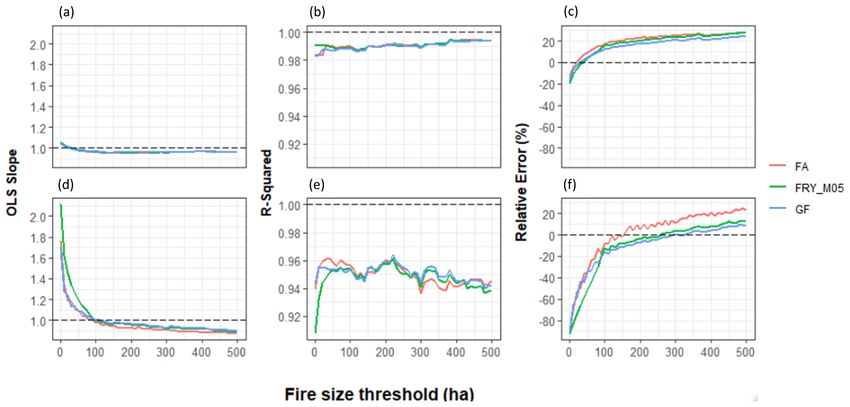
76                                                L. F. Galizia et al.: Assessing the accuracy of remotely sensed fire datasets

Figure 2. The general framework for comparison of RSDs with the GBD in terms of burned area (BA) and number of fires (NF) across a
range of individual fire size thresholds (1 to 500 ha).

GBD records (2005–2015) has been considered. We evalu-             2.3.1   Temporal agreement
ated the ability of RSDs to reproduce the temporal and spatial
patterns of fire activity observed in the GBD by fitting ordi-     All datasets were aggregated to a monthly scale over the
nary least squares (OLS) linear regressions and using differ-      whole study area. We retrieved the slope coefficient of OLS
ent metrics (OLS slope, R 2 correlation, and relative error).      regressions and the coefficient of determination (R 2 ) as a
We calculated the relative error (ε) as follows:                   proxy of agreement between RSDs and the GBD. Slope val-
                                                                   ues greater than 1 indicated an underestimation of fire activ-
            BARSD − BAGBD                                          ity as seen by the GBD and vice versa. A slope equal to 1
ε = 100 ×                 ,                                 (1)
               BAGBD                                               would imply a perfect agreement.
where BARSD represents the BA detected by remote-sensing           2.3.2   Spatial agreement
datasets and BAGBD represents the BA registered in the
ground-based dataset over the study period. The analysis was       We then sought to examine how the agreement between
repeated for the number of fires (NF).                             RSDs and the GBD varies across space. There is much un-
   We applied a land cover filter to the RSD data using            certainty in estimating the ignition point from satellite data
CORINE Land Cover (CLC) to exclude fires located within            mainly due to the spatial and temporal proximity of fire pix-
agricultural or artificial lands that are not always reported by   els and the possibility of multiple ignition points in a single
fire agencies. To account for the land cover changes over the      fire event (Benali et al., 2016). Likewise, the GBD do not sys-
study period, we used CLC 2006 as a reference to filter RSDs       tematically provide ignition points. Thus, to overcome this
from the 2005 and 2009 period and CLC 2012 from 2010 and           limitation, we aggregated both the RSDs and the GBD onto
2015. A sensitivity analysis to the land cover filter is shown     a 0.25◦ grid (≈ 25 km), setting a common ground for both
in Appendix A (Fig. A2).                                           datasets.
   As RSDs are prone to omit smaller fires (< 25 ha) due              We calculated the relative error (Eq. 1) between the RSDs
to the coarse spatial resolution of the MODIS product              and the GBD for each grid cell. Finally, we estimated the
MCD64A1 (500 m) and other limitations, we investigated             overall spatial error, computed as the ε averaged across all
different fire size thresholds increasing from 1 to 500 ha.        grid cells for each RSD.
Analyses were repeated for each size-filtered sample (i.e., ex-
cluding fires smaller than a given threshold).

Nat. Hazards Earth Syst. Sci., 21, 73–86, 2021                                       https://doi.org/10.5194/nhess-21-73-2021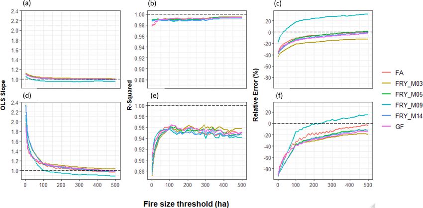
L. F. Galizia et al.: Assessing the accuracy of remotely sensed fire datasets 77
Figure 3. (a) Monthly burned area and (b) number of fires (> 1 ha) in each fire dataset across the southwestern Mediterranean Basin over
2005–2015.
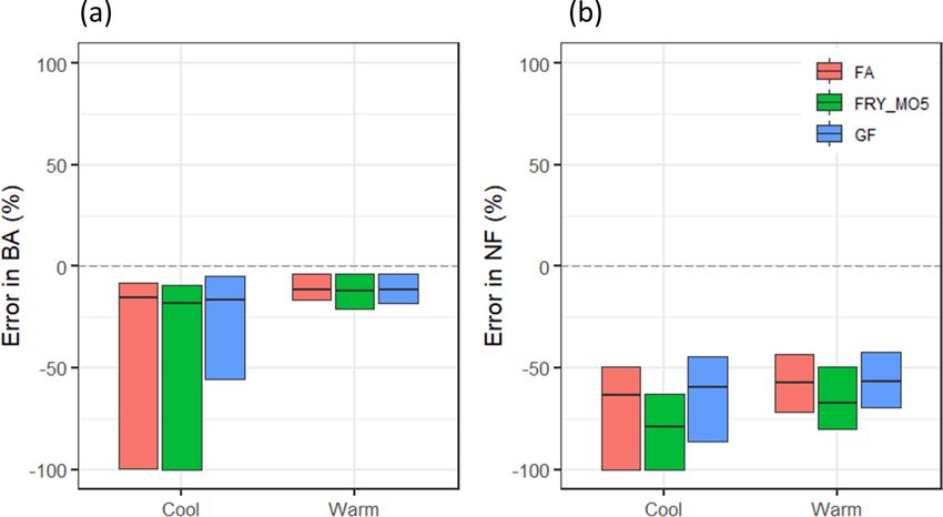
Figure 4. (a) Median and interquartile range of the seasonal error (ε) observed each year for burned area and (b) number of fires in each RSD
for all fires > 1 ha in the studied area. Cool season from November to April and warm season from May to October. Dashed lines represent
the perfect agreement between the datasets.
3 Results the period experiencing the largest fires which account for
the bulk of the BA in the region (Turco et al., 2016). Con-
3.1 Temporal agreement versely, the poorest agreement was found during the cool
season (November to April), a period dominated mainly by
small fires linked to agricultural activities.
We first analyzed the monthly distributions of BA and NF
Table 3 presents the total BA and NF, as well as the
for all fires (> 1 ha) aggregated across the whole studied
monthly (i.e., including the seasonal cycle) and annual (i.e.,
area. Figure 3 shows that RSDs follow a similar variabil-
excluding the seasonal cycle) correlation between RSDs and
ity in terms of monthly BA but systematically underesti-
the GBD for all fires (> 1 ha). Monthly correlations showed
mate BA and NF with respect to the GBD. The best agree-
a stronger agreement for BA (R 2 ≈ 0.98) than for NF (R 2 ≈
ment between RSDs and the GBD occurs mainly during the
0.89). Annual correlations, for which the effect of the sea-
warm season (May to October; see Fig. 4). This is usually
https://doi.org/10.5194/nhess-21-73-2021 Nat. Hazards Earth Syst. Sci., 21, 73–86, 2021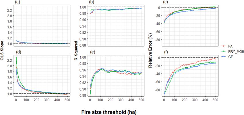
78 L. F. Galizia et al.: Assessing the accuracy of remotely sensed fire datasets
sonal cycle was removed, also showed very high values
FRY_M05 signifies FRY MODIS (5 d), and GF signifies GlobFire.
Table 2. Description of the remote-sensing datasets (RSDs) of individual fires, including the digital object identifier (DOI) and reference of each dataset. FA signifies Fire Atlas,
GF
FRY_M05
FA
RSD
(R 2 ≈ 0.99). Despite the fact that RSDs underestimated the
total BA by 38 % and the NF by 96 % for all fires, they re-
produced almost perfectly the temporal variability in both
monthly and annual bases. The difference in absolute num-
Data mining
Flood-fill algorithm
Progression-based algorithm
Methodology
bers thus relates to undetected small fires in RSDs.
The monthly agreement of BA and NF (Fig. 5) strongly
varies with fire size thresholds (1, 50, 100, and 500 ha). The
positive slope of the linear trends indicates that RSDs gen-
erally underestimate both BA and NF when accounting for
all fires (> 1 ha). However, they become progressively more
accurate as the fire size threshold increases, a feature that is
particularly evident in NF estimates (Fig. 5e–h).
Figure 6 shows the evaluation of RSDs through different
5 and 16 d
5d
4 to 10 d
Cutoff values
metrics over the continuum of fire size thresholds. Except
for R 2 (Fig. 6e) which saturates for fires > 100 ha for NF, all
metrics present a similar behavior, showing better agreement
when increasing the fire size threshold. Overall, BA (Fig. 6a,
b, and c) is better estimated than NF (Fig. 6d, e, and f). De-
2000–2019
2000–2017
2003–2016
Period
spite the different methodologies used to reconstruct individ-
ual fires, all datasets showed similar scores, although Fire
Atlas (FA) displayed lower relative error (ε) for NF.
https://doi.org/10.1594/PANGAEA.895835
https://doi.org/10.15148/0e999ffc-e220-41ac-ac85-76e92ecd0320
https://doi.org/10.3334/ORNLDAAC/1642
Dataset DOI
3.2 Spatial agreement
Figure 7 shows the spatial distribution of the relative error (ε)
for BA over different individual fire size thresholds (for all
fire size thresholds see Supplement). As expected from pre-
vious results, RSDs strongly underestimated BA, especially
when including smaller fires. However, a few exceptions are
seen for fires < 50 ha mainly over eastern Spain, suggesting
that RSDs detect in that case more fires than the GBD. This
may be related to a few small prescribed fires that were not
reported in the GBD. Also, we found much lower ε in regions
with higher fire activity, such as the northern Iberian Penin-
sula. This is rather expected as an absolute change in regions
with a high (low) baseline will result in a small (large) per-
centage change.
Likewise, RSDs strongly underestimated NF (Fig. 8),
likely disregarding those smaller fires not detected by
MODIS. Surprisingly, a few areas showed positive differ-
ences in NF for fires > 100 ha across parts of Spain. This
Artés Vivancos and San-Miguel-Ayanz (2018)
Artés et al. (2019),
Laurent et al. (2018a, b)
Andela et al. (2019a, b)
Reference
overestimation of large fires may be related to the fact that
RSD algorithms are likely to split larger fires into multiple
events. Nevertheless, the overall relative error between RSDs
and the GBD decreases when focusing on larger fires for both
NF and BA.
4 Discussion
Understanding global changes in fire activity calls for ef-
ficient and harmonized approaches to record fire activity.
Satellite-borne spectral and thermal sensors offer several
global fire products, evolving from BA mapping and ac-
Nat. Hazards Earth Syst. Sci., 21, 73–86, 2021 https://doi.org/10.5194/nhess-21-73-2021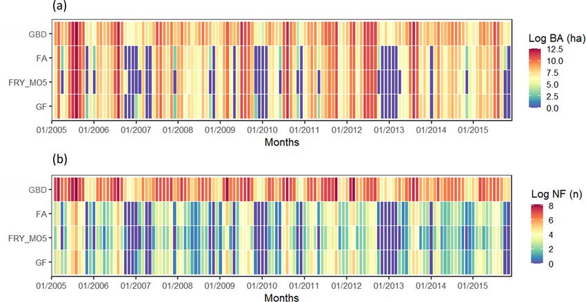
L. F. Galizia et al.: Assessing the accuracy of remotely sensed fire datasets                                                                 79

Table 3. Correlation between RSDs and the GBD of monthly and annual burned area and number of fires for all fires (> 1 ha) between 2005
and 2015.

               Dataset                          Burned area                                      Number of fires
                              Total (ha)   Mo. correlation     Yr. correlation    Total (n)   Mo. correlation      Yr. correlation
               GBD            2 527 603                   –                  –      95 561                   –                  –
               FA             1 609 267                0.99               0.99       3875                 0.90               0.99
               FRY_M05        1 524 171                0.99               0.99       2134                 0.88               0.99
               GF             1 562 001                0.98               0.99       4637                 0.90               0.99

Figure 5. Comparison of the GBD and RSDs with respect to monthly burned area (a–d) and the number of fires (e–h) when considering
(a) all fires (> 1 ha), (b) fires > 50 ha, (c) fires > 100 ha, and (d) fires > 500 ha. (e–h) Same as (a–d) but for the number of fires. The 1 : 1
dashed lines represent the perfect fit between the datasets.

tive fire detection to novel developments postprocessing BA                (Campagnolo et al., 2021; Rodrigues et al., 2019; Ying et al.,
products into single fire datasets (Chuvieco et al., 2019). The            2019; Zhu et al., 2017).
ongoing challenge lies in determining their reliability and                   The ability of RSDs to identify individual fires depends
usefulness. Here, we compared RSDs with the GBD across                     mainly on two features: the processing algorithm and the
the southwestern Mediterranean Basin to better understand                  underlying reliability of the BA product. The relatively low
RSD limitations and to guide end users.                                    capacity of the latter to detect small fires is related to the
   Although RSDs may miss a substantial number of fires, the               coarse spatial resolution (500 m) of the MODIS sensor. Sev-
temporal variations in both NF and BA match very well with                 eral recent studies have shown that MODIS products reli-
ground-based observations. Our results also demonstrate that               ably detect fires over 40–120 ha but miss a number of smaller
the agreement between RSDs and the GBD is strongly de-                     fires (Fusco et al., 2019; Giglio et al., 2018; Rodrigues et al.,
pendent on individual fire size. Focusing on larger fires (fire            2019; Zhu et al., 2017). Although other BA products, such as
typically > 100 ha), RSDs were in stronger agreement with                  FireCCI50 (Chuvieco et al., 2018), provide a finer spatial res-
the GBD regardless of the evaluated metrics. Fires >100 ha                 olution (250 m), a substantial number of small and/or highly
had a much lower error (BA 10 %; NF 35 %), especially in                   fragmented fires remain undetected, leading to a considerable
regions with higher fire activity such as the northwest of the             underestimation of BA (Roteta et al., 2019). In addition, all
Iberian Peninsula or southern Sardinia. Our findings are in                space-borne BA products face many other well-documented
agreement with previous studies which pointed at fire size                 limitations, such as the variability in orbital coverage, satel-
as the primary limiting factor for remotely sensed fire data               lite overpass time, and satellite view obstruction (Cardoso et

https://doi.org/10.5194/nhess-21-73-2021                                                Nat. Hazards Earth Syst. Sci., 21, 73–86, 2021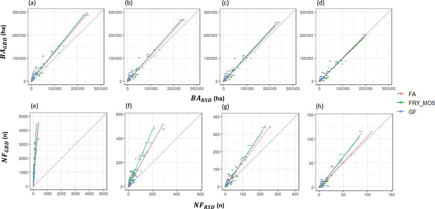
80                                                     L. F. Galizia et al.: Assessing the accuracy of remotely sensed fire datasets

Figure 6. Evaluation of RSDs through different metrics including the slope (a, d), R 2 correlation (b, e), and relative error (c, f) for both
burned area (a–c) and the number of fires (d–f) over a range of individual fire size thresholds (1 to 500 ha). Dashed lines indicate a perfect fit
between RSDs and the GBD.

Figure 7. The relative error (ε) of the total burned area computed as the relative difference between RSDs and GBD data over different
individual fire size thresholds (1, 50, 100, and 500 ha). The overall ε is indicated on each map.

Nat. Hazards Earth Syst. Sci., 21, 73–86, 2021                                                  https://doi.org/10.5194/nhess-21-73-2021
L. F. Galizia et al.: Assessing the accuracy of remotely sensed fire datasets                                                        81

Figure 8. Same as Fig. 7 but for number of fires.

al., 2005; Padilla et al., 2014). In this sense, detectability may     very much to the total annual burned area but significantly
vary regionally across the globe, and without ground-based             harm the performance of the RSDs in terms of NF.
fire datasets, it may be difficult to properly validate their re-         The selection of an appropriate fire size threshold depends
liability (Turco et al., 2019). Nonetheless, the limitations of        on the objectives of each analysis. However, in this study, we
MCD64A1 are inherent to all RSDs since all of the analyzed             can generally recommend a minimum size of 100 ha, which
products were built on this basis. Hence, differences among            stands out as a change point in multiple statistics (Figs. 6 to
RSDs are rather expected to be associated with the underly-            8), with the relative error sharply decreasing in both BA and
ing algorithm used to identify single fire events.                     NF above this threshold. Among the analyzed RSDs, FA dis-
   RSDs were found to better estimate BA than NF. This dis-            played a slightly better performance with a lower relative er-
parity relies on the complexity of extracting individual fires         ror. This may arise from the use of a spatially explicit cutoff
from gridded BA products. Environmental conditions (e.g.,              threshold, taking both fire spread rate and satellite coverage
topography, cloud/smoke cover) may influence the sensor de-            into account to track the extent of individual fires (Andela
tection power, resulting in a break in BA continuity, thereby          et al., 2019b). However, uncertainty in MODIS largely out-
increasing the risk of artificially splitting single fires into dif-   paces the uncertainties across the RSDs. The low capacity of
ferent fire events. Likewise, if a fire lasts longer than the de-      gridded BA products to detect small to mid-sized fire events
fined cutoff window, it will be automatically split into differ-       (< 100 ha) can be improved by the generation of products
ent events (Oom et al., 2016). By contrast, if multiple fires          based on higher-resolution sensors in the range of 10–30 m
occur simultaneously in the same region, the parameteriza-             (Roteta et al., 2019). RSDs of individual fires derived from
tion of the RSD algorithms may merge multiple individual               finer-gridded BAs would provide a better estimate of actual
fires (Archibald et al., 2013). Lastly, regional features of the       NF. In addition, the MCD64A1 product already incorporates
fire regime may constrain RSD accuracy. For instance, the              the uncertainty of detection as an auxiliary variable of grid-
Mediterranean fire regime is known for hosting numerous                ded BA data (Giglio et al., 2018). RSDs could benefit from
small fires which are unlikely to be detected by satellite ob-         this and report similar information at the individual fire level.
servations (Turco et al., 2016). These fires do not contribute

https://doi.org/10.5194/nhess-21-73-2021                                           Nat. Hazards Earth Syst. Sci., 21, 73–86, 2021
82                                                 L. F. Galizia et al.: Assessing the accuracy of remotely sensed fire datasets

   The spatiotemporal aggregation applied in our study is               We found a better agreement during the warm season (May
expected to increase the signal-to-noise ratio and thus de-          to October), the main fire season in southern Europe, espe-
crease the uncertainty in RSD estimates. According to                cially in regions with higher fire activity (northern Iberian
Turco (2019), the agreement between remotely sensed and              Peninsula and southern Sardinia). Also, RSDs were found to
ground-based fire data increases at lower resolutions, being         better estimate BA than NF. This is rather expected as nu-
generally best when aggregating the data onto a 1◦ grid (ap-         merous small fires, which are not detected by satellites, do
proximately 110 km) or beyond. Likewise, aggregating the             not contribute very much to the total burned area across the
data over time (either monthly or annually) also increases           study region.
the signal-to-noise ratio by filtering out sub-monthly varia-           In practical applications, our results may provide guid-
tions (Spadavecchia and Williams, 2009). Evaluating RSDs             ance for end users. A quantitative estimate of uncertainty
on shorter timescales and/or at finer spatial resolutions would      is crucial for the correct interpretation of RSDs, and users
likely deteriorate the agreement with the GBD. Nevertheless,         should take into account their limitations. Our findings sug-
the spatiotemporal aggregation, such as the one employed             gest that global RSDs of individual fires can be used to proxy
here, has been extensively used in previous studies analyz-          variations in fire activity on monthly or annual timescales;
ing fire regimes at regional (Barbero et al., 2014; Jiménez-         however, caution is advised when drawing conclusions from
Ruano et al., 2020; Parisien et al., 2014) and global (Bedia         smaller fires (< 100 ha) across the Mediterranean region. Fire
et al., 2015; Di Giuseppe et al., 2016; Turco et al., 2018b)         agencies may also benefit from the spatial and temporal con-
scales.                                                              sistency of remote-sensing data to support their operational
   Further studies are still needed to evaluate RSD spatiotem-       fire mapping system at the regional/national level. Future
poral variability in the fire patch level (i.e., assign individual   studies using high-quality ground-based fire data in other re-
fires from RSDs to the GBD) in order to more precisely quan-         gions of the world featuring different fire regimes would pro-
tify the dataset accuracy at the fire scale.                         vide further insights into RSD uncertainties.

5    Conclusion

In this work, we built upon previous research and investi-
gated the reliability of three RSDs of individual fires over a
range of fire size thresholds across the southwestern Mediter-
ranean Basin. Overall, RSDs contain only a small fraction
of the total number of fires documented by the GBD. How-
ever, they capture reasonably well the temporal variability in
fire activity across monthly and annual scales. Despite the
different methodologies used to reconstruct fire patches, all
RSDs performed similarly and were increasingly accurate
when focusing on larger fires. Specifically, when consider-
ing fires > 100 ha, RSDs showed reasonable agreement with
the GBD.
   Generally, the RSDs’ underestimation of BA and NF for
smaller fires is related to the coarse spatial resolution (500 m)
of the pixel-based BA product and other observation lim-
itations which prevented the detection of small fires. Fea-
tures of the fire regime at regional scales may also influence
the agreement between RSDs and the GBD (e.g., fire dura-
tion, density, and spread rate). In this sense, our analysis was
framed in the southwestern Mediterranean region to capture
homogeneous conditions in terms of fire regimes.

Nat. Hazards Earth Syst. Sci., 21, 73–86, 2021                                        https://doi.org/10.5194/nhess-21-73-2021
L. F. Galizia et al.: Assessing the accuracy of remotely sensed fire datasets                                                                  83

Appendix A

Figure A1. Evaluation of RSDs including all FRY cutoff values (3 to 14 d) through different metrics including the slope (a, d), R 2 correla-
tion (b, e), and relative error (c, f) for both burned area (a–c) and the number of fires (d–f) over a range of individual fire size thresholds (1
to 500 ha). Dashed lines indicate a perfect fit between RSDs and the GBD.

Figure A2. Evaluation of “raw” RSDs (i.e., without the land cover filter) through different metrics including the slope (a, d), R 2 correla-
tion (b, e), and relative error (c, f) for both burned area (a–c) and the number of fires (d–f) over a range of individual fire size thresholds (1
to 500 ha). Dashed lines indicate a perfect fit between RSDs and the GBD.

https://doi.org/10.5194/nhess-21-73-2021                                                 Nat. Hazards Earth Syst. Sci., 21, 73–86, 2021
84                                                     L. F. Galizia et al.: Assessing the accuracy of remotely sensed fire datasets

Data availability. The above-described fire datasets, their charac-       Artés, T., Oom, D., de Rigo, D., Durrant, T. H., Maianti, P., Lib-
teristics, and references to access the data can be found in Ta-            ertà, G., and San-Miguel-Ayanz, J.: A global wildfire dataset for
bles 1 and 2. All these fire datasets are open access except one            the analysis of fire regimes and fire behaviour, Sci. Data, 6, 296,
of the ground-based datasets (EGIF) which is available upon re-             https://doi.org/10.1038/s41597-019-0312-2, 2019.
quest. The different data producers host the data in different            Artés Vivancos, T. and San-Miguel-Ayanz, J.: Global Wild-
ways, typically using websites or data repositories. The harmo-             fire Database for GWIS, Suppl. to Artés Vivancos, Tomàs,
nized GBD used here as the ground-based reference is available at           Oom, Duarte, Rigo, Daniele, Houst. Durrant, Tracy, Ma-
https://doi.org/10.5281/zenodo.3905040 (Galizia et al., 2020).              ianti, Pieralberto, Lib. Giorgio, San-Miguel-Ayanz, Jesús A
                                                                            Glob. wildfire dataset Anal. fire regimes fire Behav. Sci.,
                                                                            https://doi.org/10.1594/PANGAEA.895835, 2018.
Supplement. The supplement related to this article is available on-       Barbero, R., Abatzoglou, J. T., Steel, E. A., and Larkin, N. K.:
line at: https://doi.org/10.5194/nhess-21-73-2021-supplement.               Modeling very large-fire occurrences over the continental United
                                                                            States from weather and climate forcing, Environ. Res. Lett., 9,
                                                                            124009, https://doi.org/10.1088/1748-9326/9/12/124009, 2014.
Author contributions. LG performed the data curation, formal anal-        Bedia, J., Herrera, S., Gutiérrez, J. M., Benali, A., Brands,
ysis, validation, and visualization and wrote the original paper,           S., Mota, B., and Moreno, J. M.: Global patterns in the
while all authors edited it. LG, TC, RB, and MR were responsi-              sensitivity of burned area to fire-weather: Implications for
ble for the conceptualization and determined the methodology. TC            climate change, Agr. Forest Meteorol., 214–215, 369–379,
and RB were responsible for supervision.                                    https://doi.org/10.1016/j.agrformet.2015.09.002, 2015.
                                                                          Benali, A., Russo, A., Sá, A. C. L., Pinto, R. M. S., Price, O., Kout-
                                                                            sias, N., and Pereira, J. M. C.: Determining fire dates and lo-
                                                                            cating ignition points with satellite data, Remote Sens., 8, 326,
Competing interests. The authors declare that they have no conflict
                                                                            https://doi.org/10.3390/rs8040326, 2016.
of interest.
                                                                          Bowman, D. M. J. S., Bowman, D. M. J. S., Balch, J. K., Artaxo, P.,
                                                                            Bond, W. J., Carlson, J. M., Cochrane, M. A., Antonio, C. M. D.,
                                                                            Defries, R. S., Doyle, J. C., Harrison, S. P., Johnston, F. H., Kee-
Special issue statement. This article is part of the special issue “Re-     ley, J. E., and Krawchuk, M. A.: Fire in the Earth System, Sci-
mote sensing and Earth observation data in natural hazard and risk          ence, 481, 481–484, https://doi.org/10.1126/science.1163886,
studies”. It is not associated with a conference.                           2009.
                                                                          Campagnolo, M. L., Libonati, R., Rodrigues, J. A., and Pereira,
                                                                            J. M. C.: Remote Sensing of Environment A comprehensive
Acknowledgements. We would also like to thank Christophe Bouil-             characterization of MODIS daily burned area mapping accuracy
lon and Fabien Guerra for supporting the harmonization of regional          across fire sizes in tropical savannas, Remote Sens. Environ.,
agencies’ fire datasets.                                                    252, 112115, https://doi.org/10.1016/j.rse.2020.112115, 2021.
                                                                          Cardoso, M. F., Hurtt, G. C., Moore, B., Nobre, C. A., and Bain,
                                                                            H.: Field work and statistical analyses for enhanced interpreta-
Review statement. This paper was edited by Mahdi Motagh and re-             tion of satellite fire data, Remote Sens. Environ., 96, 212–227,
viewed by two anonymous referees.                                           https://doi.org/10.1016/j.rse.2005.02.008, 2005.
                                                                          Chuvieco, E., Lizundia-Loiola, J., Pettinari, M. L., Ramo, R.,
                                                                            Padilla, M., Tansey, K., Mouillot, F., Laurent, P., Storm, T., Heil,
                                                                            A., and Plummer, S.: Generation and analysis of a new global
References                                                                  burned area product based on MODIS 250 m reflectance bands
                                                                            and thermal anomalies, Earth Syst. Sci. Data, 10, 2015–2031,
Andela, N., Morton, D. C., Giglio, L., and Anderson, J. T.: Global          https://doi.org/10.5194/essd-10-2015-2018, 2018.
  Fire Atlas with Characteristics of Individual Fires, 2003–2016,         Chuvieco, E., Mouillot, F., van der Werf, G. R., San Miguel, J.,
  ORNL DAAC, https://doi.org/10.3334/ORNLDAAC/1642,                         Tanasse, M., Koutsias, N., García, M., Yebra, M., Padilla, M., Gi-
  2019a.                                                                    tas, I., Heil, A., Hawbaker, T. J., and Giglio, L.: Historical back-
Andela, N., Morton, D. C., Giglio, L., Paugam, R., Chen,                    ground and current developments for mapping burned area from
  Y., Hantson, S., van der Werf, G. R., and Randerson, J.                   satellite Earth observation, Remote Sens. Environ., 225, 45–64,
  T.: The Global Fire Atlas of individual fire size, duration,              https://doi.org/10.1016/j.rse.2019.02.013, 2019.
  speed and direction, Earth Syst. Sci. Data, 11, 529–552,                Curt, T., Fréjaville, T., and Bouillon, C.: Characterizing pyrore-
  https://doi.org/10.5194/essd-11-529-2019, 2019b.                          gions in south-eastern France, Adv. For. Fire Res., 4, 1093–1101,
Archibald, S. and Roy, D. P.: Identifying individual fires from             https://doi.org/10.14195/978-989-26-0884-6_119, 2014.
  satellite-derived burned area data, in: 2009 IEEE International         Di Giuseppe, F., Pappenberger, F., Wetterhall, F., Krzeminski,
  Geoscience and Remote Sensing Symposium, vol. 3, III-160–III-             B., Camia, A., Libertá, G., and Miguel, J. S.: The po-
  163, 2009.                                                                tential predictability of fire danger provided by numerical
Archibald, S., Lehmann, C. E. R., Gómez-Dans, J. L., and                    weather prediction, J. Appl. Meteorol. Clim., 55, 2469–2491,
  Bradstock, R. A.: Defining pyromes and global syndromes                   https://doi.org/10.1175/JAMC-D-15-0297.1, 2016.
  of fire regimes, P. Natl. Acad. Sci. USA, 110, 6442–6447,
  https://doi.org/10.1073/pnas.1211466110, 2013.

Nat. Hazards Earth Syst. Sci., 21, 73–86, 2021                                                https://doi.org/10.5194/nhess-21-73-2021
L. F. Galizia et al.: Assessing the accuracy of remotely sensed fire datasets 85
Dupuy, J. L., Fargeon, H., Martin-StPaul, N., Pimont, F., Ruffault, rope: Spain, Portugal, Greece and Sardinia (Italy), Int. J. Wild-
J., Guijarro, M., Hernando, C., Madrigal, J., and Fernandes, land Fire, 28, 85–98, https://doi.org/10.1071/WF18004, 2019.
P.: Climate change impact on future wildfire danger and activ- Moreira, F., Viedma, O., Arianoutsou, M., Curt, T., Koutsias,
ity in southern Europe: a review, Ann. Forest Sci., 77, 1–49, N., Rigolot, E., Barbati, A., Corona, P., Vaz, P., Xanthopou-
https://doi.org/10.1007/s13595-020-00933-5, 2020. los, G., Mouillot, F., and Bilgili, E.: Landscape – wild-
Fusco, E. J., Finn, J. T., Abatzoglou, J. T., Balch, J. K., Dadashi, fire interactions in southern Europe: Implications for land-
S., and Bradley, B. A.: Detection rates and biases of fire ob- scape management, J. Environ. Manage., 92, 2389–2402,
servations from MODIS and agency reports in the conter- https://doi.org/10.1016/j.jenvman.2011.06.028, 2011.
minous United States, Remote Sens. Environ., 220, 30–40, Moreira, F., Ascoli, D., Safford, H., Adams, M. A., Moreno, J.
https://doi.org/10.1016/j.rse.2018.10.028, 2019. M., Pereira, J. M. C., Catry, F. X., Armesto, J., Bond, W.,
Galizia, L. F., Curt, T., Barbero, R., and Rodrigues, M.: Harmo- González, M. E., Curt, T., Koutsias, N., McCaw, L., Price,
nized fire agencies dataset across the Southwestern Mediter- O., Pausas, J. G., Rigolot, E., Stephens, S., Tavsanoglu, C.,
ranean basin, Zenodo, https://doi.org/10.5281/zenodo.3905040, Vallejo, V. R., Van Wilgen, B. W., Xanthopoulos, G., and Fer-
2020. nandes, P. M.: Wildfire management in Mediterranean-type re-
Ganteaume, A., Camia, A., Jappiot, M., San-Miguel-Ayanz, J., gions: Paradigm change needed, Environ. Res. Lett., 15, 011001,
Long-Fournel, M., and Lampin, C.: A review of the main driving https://doi.org/10.1088/1748-9326/ab541e, 2020.
factors of forest fire ignition over Europe, Environ. Manage., 51, Mouillot, F. and Field, C. B.: Fire history and the global carbon
651–662, https://doi.org/10.1007/s00267-012-9961-z, 2013. budget: A 1◦ × 1◦ fire history reconstruction for the 20th century,
Giglio, L., Randerson, J. T., and Van Der Werf, G. R.: Analy- Glob. Change Biol., 11, 398–420, https://doi.org/10.1111/j.1365-
sis of daily, monthly, and annual burned area using the fourth- 2486.2005.00920.x, 2005.
generation global fire emissions database (GFED4), J. Geophys. Mouillot, F., Schultz, M. G., Yue, C., Cadule, P., Tansey,
Res.-Biogeo., 118, 317–328, https://doi.org/10.1002/jgrg.20042, K., Ciais, P., and Chuvieco, E.: Ten years of global
2013. burned area products from spaceborne remote sensing-A re-
Giglio, L., Boschetti, L., Roy, D. P., Humber, M. L., and Jus- view: Analysis of user needs and recommendations for fu-
tice, C. O.: The Collection 6 MODIS burned area mapping ture developments, Int. J. Appl. Earth Obs., 26, 64–79,
algorithm and product, Remote Sens. Environ., 217, 72–85, https://doi.org/10.1016/j.jag.2013.05.014, 2014.
https://doi.org/10.1016/j.rse.2018.08.005, 2018. Nogueira, J. M. P., Ruffault, J., Chuvieco, E., and Mouillot, F.: Can
Hantson, S., Pueyo, S., and Chuvieco, E.: Global fire size distribu- we go beyond burned area in the assessment of global remote
tion is driven by human impact and climate, Global Ecol. Bio- sensing products with fire patch metrics?, Remote Sens., 9, p. 7,
geogr., 24, 77–86, https://doi.org/10.1111/geb.12246, 2015. https://doi.org/10.3390/rs9010007, 2017.
Hantson, S., Arneth, A., Harrison, S. P., Kelley, D. I., Prentice, I. C., Oom, D., Silva, P. C., Bistinas, I., and Pereira, J. M. C.: Highlight-
Rabin, S. S., Archibald, S., Mouillot, F., Arnold, S. R., Artaxo, ing biome-specific sensitivity of fire size distributions to time-
P., Bachelet, D., Ciais, P., Forrest, M., Friedlingstein, P., Hickler, gap parameter using a new algorithm for fire event individuation,
T., Kaplan, J. O., Kloster, S., Knorr, W., Lasslop, G., Li, F., Man- Remote Sens., 8, 1–15, https://doi.org/10.3390/rs8080663, 2016.
geon, S., Melton, J. R., Meyn, A., Sitch, S., Spessa, A., van der Padilla, M., Stehman, S. V., and Chuvieco, E.: Validation of the
Werf, G. R., Voulgarakis, A., and Yue, C.: The status and chal- 2008 MODIS-MCD45 global burned area product using strat-
lenge of global fire modelling, Biogeosciences, 13, 3359–3375, ified random sampling, Remote Sens. Environ., 144, 187–196,
https://doi.org/10.5194/bg-13-3359-2016, 2016. https://doi.org/10.1016/j.rse.2014.01.008, 2014.
Jiménez-Ruano, A., de la Riva Fernández, J., and Rodrigues, M.: Parisien, M.-A., Parks, S. A., Krawchuk, M. A., Little, J. M., Flan-
Fire regime dynamics in mainland Spain. Part 2: A near-future nigan, M. D., Gowman, L. M., and Moritz, M. A.: An analysis
prospective of fire activity, Sci. Total Environ., 705, 135842, of controls on fire activity in boreal Canada: comparing models
https://doi.org/10.1016/j.scitotenv.2019.135842, 2020. built with different temporal resolutions, Ecol. Appl., 24, 1341–
Keeley, J. E., Bond, W. J., Bradstock, R. A., Pausas, J. G., and Run- 1356, 2014.
del, P. W.: Fire in Mediterranean ecosystems: ecology, evolu- Pausas, J. G. and Fernández-Muñoz, S.: Fire regime changes
tion and management, Cambridge University Press, New York, in the Western Mediterranean Basin: From fuel-limited to
United States of America, 2011. drought-driven fire regime, Clim. Change, 110, 215–226,
Laurent, P., Mouillot, F., Yue, C., Ciais, P., Moreno, M. https://doi.org/10.1007/s10584-011-0060-6, 2012.
V., and Nogueira, J. M. P.: Data Descriptor: FRY, a Pereira, M. G., Malamud, B. D., Trigo, R. M., and Alves, P. I.:
global database of fire patch functional traits derived from The history and characteristics of the 1980–2005 Portuguese ru-
space-borne burned area products, Sci. Data, 5, 1–12, ral fire database, Nat. Hazards Earth Syst. Sci., 11, 3343–3358,
https://doi.org/10.1038/sdata.2018.132, 2018a. https://doi.org/10.5194/nhess-11-3343-2011, 2011.
Laurent, P., Mouillot, F., Yue, C., Ciais, P., Moreno, M. V., and Randerson, J. T., Van Der Werf, G. R., Giglio, L., Col-
Nogueira, J. M. P.: FRY: a global database of fire patch func- latz, G. J., and Kasibhatla, P. S.: Global Fire Emis-
tional traits, France, https://doi.org/10.15148/0e999ffc-e220- sions Database, Version 4.1 (GFEDv4), ORNL DAAC,
41ac-ac85-76e92ecd0320, 2018b. https://doi.org/10.3334/ORNLDAAC/1293, 2015.
Molina-Terrén, D. M., Xanthopoulos, G., Diakakis, M., Ribeiro, Rodrigues, J. A., Libonati, R., Pereira, A. A., Nogueira, J. M. P.,
L., Caballero, D., Delogu, G. M., Viegas, D. X., Silva, C. A., Santos, F. L. M., Peres, L. F., Santa Rosa, A., Schroeder, W.,
and Cardil, A.: Analysis of forest fire fatalities in Southern Eu- Pereira, J. M. C., Giglio, L., Trigo, I. F., and Setzer, A. W.:
How well do global burned area products represent fire patterns
https://doi.org/10.5194/nhess-21-73-2021 Nat. Hazards Earth Syst. Sci., 21, 73–86, 202186 L. F. Galizia et al.: Assessing the accuracy of remotely sensed fire datasets in the Brazilian Savannas biome? An accuracy assessment of Turco, M., Rosa-Cánovas, J. J., Bedia, J., Jerez, S., Montávez, the MCD64 collections, Int. J. Appl. Earth Obs., 78, 318–331, J. P., Llasat, M. C., and Provenzale, A.: Exacerbated fires in https://doi.org/10.1016/j.jag.2019.02.010, 2019. Mediterranean Europe due to anthropogenic warming projected Rodrigues, M., Trigo, R. M., Vega-García, C., and Cardil, with non-stationary climate-fire models, Nat. Commun., 9, 1–9, A.: Identifying large fire weather typologies in the https://doi.org/10.1038/s41467-018-06358-z, 2018a. Iberian Peninsula, Agr. Forest Meteorol., 280, 107789, Turco, M., Jerez, S., Doblas-Reyes, F. J., Aghakouchak, A., Llasat, https://doi.org/10.1016/j.agrformet.2019.107789, 2020. M. C., and Provenzale, A.: Skilful forecasting of global fire activ- Roteta, E., Bastarrika, A., Padilla, M., Storm, T., and Chuvieco, E.: ity using seasonal climate predictions, Nat. Commun., 9, 2718, Development of a Sentinel-2 burned area algorithm: Generation https://doi.org/10.1038/s41467-018-05250-0, 2018b. of a small fire database for sub-Saharan Africa, Remote Sens. Turco, M., Herrera, S., Tourigny, E., Chuvieco, E., and Provenzale, Environ., 222, 1–17, https://doi.org/10.1016/j.rse.2018.12.011, A.: A comparison of remotely-sensed and inventory datasets for 2019. burned area in Mediterranean Europe, Int. J. Appl. Earth Obs., Ruffault, J., Curt, T., Moron, V., Trigo, R., Mouillot, F., Kout- 82, 101887, https://doi.org/10.1016/j.jag.2019.05.020, 2019. sias, N., Pimont, F., Martin-StPaul, N., Barbero, R., Dupuy, van der Werf, G. R., Randerson, J. T., Giglio, L., van Leeuwen, T. J.-L., Russo, A., and Belhadj-Kheder, C.: Increased likelihood T., Chen, Y., Rogers, B. M., Mu, M., van Marle, M. J. E., Morton, of heat-induced large wildfires in the Mediterranean Basin, D. C., Collatz, G. J., Yokelson, R. J., and Kasibhatla, P. S.: Global Sci. Rep.-UK, 10, 13790, https://doi.org/10.1038/s41598-020- fire emissions estimates during 1997–2016, Earth Syst. Sci. Data, 70069-z, 2020. 9, 697–720, https://doi.org/10.5194/essd-9-697-2017, 2017. Salis, M., Ager, A. A., Arca, B., Finney, M. A., Bacciu, V., Duce, Williams, A. P. and Abatzoglou, J. T.: Recent Advances and Re- P., and Spano, D.: Assessing exposure of human and ecological maining Uncertainties in Resolving Past and Future Climate Ef- values to wildfire in Sardinia, Italy, Int. J. Wildland Fire, 22, 549– fects on Global Fire Activity, Curr. Clim. Chang. Reports, 2, 1– 565, https://doi.org/10.1071/WF11060, 2013. 14, https://doi.org/10.1007/s40641-016-0031-0, 2016. San-Miguel-Ayanz, J., Schmuck, G., Durrant, T., Boca, R., Lib- Ying, L., Shen, Z., Yang, M., and Piao, S.: Wildfire detec- ertà, G., Petroliagkis, T., Di Leo, M., Rodrigues, D., Boc- tion probability of MODIS fire products under the con- cacci, F., and Schulte, E.: Forest fires in Europe, Middle East straint of environmental factors: A study based on con- and North Africa 2014, Sci. Tech. Res. Ser., 107, 0–114, firmed ground wildfire records, Remote Sens., 11, 3031, https://doi.org/10.2788/1082, 2015. https://doi.org/10.3390/rs11243031, 2019. San-Miguel-Ayanz, J., Durrant, T., Boca, R., Libertà, G., Branco, Zhu, C., Kobayashi, H., Kanaya, Y., and Saito, M.: Size-dependent A., De Rigo, D., Ferrari, D., Maianti, P., Vivancos, T. A., and validation of MODIS MCD64A1 burned area over six vegetation Costa, H.: Forest fires in Europe, Middle East North Africa, 10, types in boreal Eurasia: Large underestimation in croplands, Sci. Sci. Tech. Res. Ser., https://doi.org/10.2760/663443, 2017. Rep.-UK, 7, 1–9, https://doi.org/10.1038/s41598-017-03739-0, Spadavecchia, L. and Williams, M.: Can spatio-temporal geosta- 2017. tistical methods improve high resolution regionalisation of me- teorological variables?, Agr. Forest Meteorol., 149, 1105–1117, https://doi.org/10.1016/j.agrformet.2009.01.008, 2009. Turco, M., Bedia, J., Di Liberto, F., Fiorucci, P., Von Hardenberg, J., Koutsias, N., Llasat, M. C., Xystrakis, F., and Provenzale, A.: Decreasing fires in mediterranean Europe, PLoS One, 11, e0150663, https://doi.org/10.1371/journal.pone.0150663, 2016. Nat. Hazards Earth Syst. Sci., 21, 73–86, 2021 https://doi.org/10.5194/nhess-21-73-2021
You can also read