Broad Scale Intertidal Habitat Mapping of Te Awarua-o-Porirua Harbour - Greater Wellington Regional Council
←
→
Page content transcription
If your browser does not render page correctly, please read the page content below
r

  Broad Scale Intertidal Habitat Mapping
  of Te Awarua-o-Porirua Harbour

Prepared for
                                           Salt Ecology
Greater Wellington Regional Council
                                           Report 050
October 2020

   For the environment
   Mō te taiao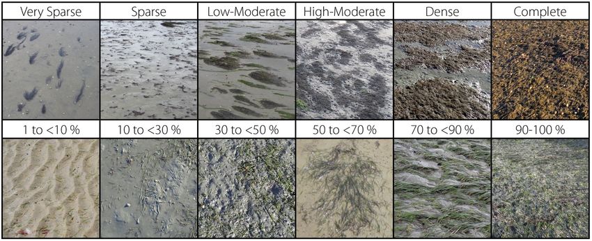
RECOMMENDED CITATION
Stevens LM, Forrest BM. 2020. Broad Scale Intertidal Habitat Mapping of Te Awarua-o-Porirua Harbour. Salt
Ecology Report 050, prepared for Greater Wellington Regional Council, October 2020. 46p.

                                                                                               For the People
                                                                                               Mō ngā tāngata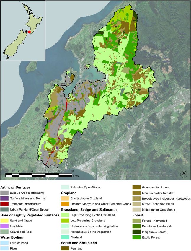
Broad Scale Intertidal Habitat Mapping
                      of Te Awarua-o-Porirua Harbour

                                          Prepared by

                                      Leigh Stevens
                                   and Barrie Forrest

                                               for

                        Greater Wellington Regional Council

                                      October 2020

                            leigh@saltecology.co.nz, +64 (0)21 417 936
                                     www.saltecology.co.nz

For the environment
Mō te taiao
GLOSSARY

AIH        Available Intertidal Habitat
aRPD       Apparent Redox Potential Discontinuity
DOC        Department of Conservation
EQR        Ecological Quality Rating
ETI        Estuary Trophic Index
GIS        Geographic Information System
GEZ        Gross Eutrophic Zone
GWRC       Greater Wellington Regional Council
HEC        Area of High Enrichment Conditions
LCDB       Land Cover Data Base
NEMP       National Estuary Monitoring Protocol
OMBT       Opportunistic Macroalgal Blooming Tool
PCC        Porirua City Council
SOE        State of Environment (monitoring)
TOC        Total Organic Carbon

ACKNOWLEDGEMENTS
Many thanks to Dr Megan Melidonis (GWRC) for review comments on the draft report. We are also grateful to
Sabine O’Neill-Stevens (Salt Ecology) for field assistance. The tools used to produce GIS summaries and maps
were developed by Megan Southwick (Salt Ecology).

                                                                                                 For the People
                                                                                                 Mō ngā tāngata
TABLE OF CONTENTS
1.         INTRODUCTION ............................................................................................................................................. 1
  1.1        GENERAL BACKGROUND........................................................................................................................................................................... 1
  1.2        BACKGROUND TO TE AWARUA-O- PORIRUA HARBOUR...................................................................................................... 1

2.         BROAD SCALE METHODS ............................................................................................................................ 4
  2.1        OVERVIEW OF MAPPING ............................................................................................................................................................................ 4
  2.2        SUBSTRATE ASSESSMENT ......................................................................................................................................................................... 5
    2.2.1 Substrate mapping............................................................................................................................................................................ 5
    2.2.2 Sediment mud content and trophic status ....................................................................................................................... 5
  2.3 OPPORTUNISTIC MACROALGAE ASSESSMENT ............................................................................................................................ 6
  2.4        SEAGRASS ASSESSMENT ............................................................................................................................................................................ 7
  2.5        SALT MARSH ASSESSMENT ...................................................................................................................................................................... 7
  2.6        TERRESTRIAL MARGIN ASSESSMENT .................................................................................................................................................. 8
  2.7        DATA RECORDING, QA/QC AND ANALYSIS ................................................................................................................................... 8
  2.8        ASSESSMENT OF ESTUARY CONDITION AND TEMPORAL CHANGE ............................................................................... 8

3.         RESULTS AND DISCUSSION ...................................................................................................................... 10
  3.1        INTERTIDAL SUBSTRATE .......................................................................................................................................................................... 10
  3.2        OPPORTUNISTIC MACROALGAE ........................................................................................................................................................ 14
  3.3        SEAGRASS ........................................................................................................................................................................................................ 19
  3.4        SALT MARSH .................................................................................................................................................................................................. 22
  3.5        TERRESTRIAL MARGIN .............................................................................................................................................................................. 25

4.         SYNTHESIS AND RECOMMENDATIONS ................................................................................................. 27
  4.1        Synthesis of key findings ........................................................................................................................................................................ 27
  4.2        Recommendations .................................................................................................................................................................................... 29

5.         REFERENCES CITED .................................................................................................................................... 30

APPENDIX 1. BROADSCALE HABITAT CLASSIFICATION DEFINITIONS .......................................................................................... 33
APPENDIX 2. ANALYTICAL METHODS FOR SEDIMENT SAMPLES (RJ HILL LABORATORIES) ........................................... 35
APPENDIX 3. OPPORTUNTISTIC MACROALGAL BLOOMING TOOL ............................................................................................... 36
APPENDIX 4. INFORMATION SUPPORTING RATINGS IN REPORT TABLE 4 ................................................................................. 42
APPENDIX 5. SEDIMENT SAMPLING VALIDATION DATA ...................................................................................................................... 44
APPENDIX 6. SALT MARSH VEGETATION DETAIL ...................................................................................................................................... 46

For the environment
Mō te taiao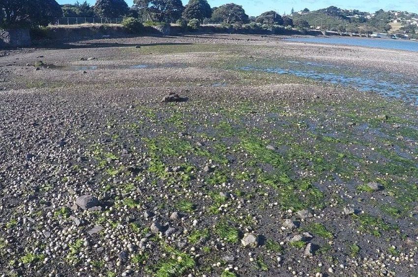
FIGURES
Fig. 1 Te Awarua-o-Porirua Harbour and surrounding catchment. ................................................................................................. 3
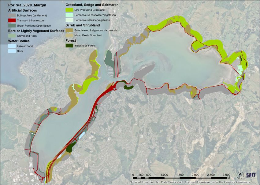
Fig. 2 Visual rating scale for percentage cover estimates. Macroalgae (top), seagrass (bottom). ................................. 7
Fig. 3 Map of dominant intertidal substrate types, Te Awarua-o-Porirua Harbour January 2020. ............................. 11
Fig. 4 Map of intertidal substrate types showing area of mud-elevated (>25-50% mud) and mud-dominated
(>50% mud) sediment, Te Awarua-o-Porirua Harbour January 2020.). ...................................................................................... 12
Fig. 5 Distribution and percentage cover classes of opportunistic macroalgae, Te Awarua-o-Porirua Harbour
January 2020. .................................................................................................................................................................................................................. 15
Fig. 6 Biomass (wet weight g/m2) classes of opportunistic macroalgae, Te Awarua-o-Porirua Harbour January
2020. ..................................................................................................................................................................................................................................... 16
Fig. 7 Distribution and percentage cover classes of seagrass, Te Awarua-o-Porirua Harbour January 2020.. .... 20
Fig. 8 Distribution and type of saltmarsh, Te Awarua-o-Porirua Harbour January 2020. ................................................. 24
Fig. 9 Distribution and classes (LCDB5 20018) of vegetation in the 200m terrestrial margin, Te Awarua-o-
Porirua Harbour January 2020.............................................................................................................................................................................. 26
TABLES
Table 1. Summary of catchment land cover (LCDB5 2018) for Te Awarua-o-Porirua Harbour. ...................................... 2
Table 2. Overview of the ecological significance of various vegetation types. ........................................................................ 4
Table 3. Substrate classification codes used in the current report. .................................................................................................. 6
Table 4. Indicators and condition rating criteria used to assess results in the current report. ........................................ 9
Table 5. Summary of dominant intertidal substrates, with examples of dominant substrate types........................ 10
Table 6. Summary of intertidal macroalgae cover classes. ................................................................................................................. 14
Table 7. Summary of OMBT input metrics and calculation of overall macroalgal ecological quality rating, Te
Awarua-o-Porirua Harbour January 2020. ..................................................................................................................................................... 18
Table 8. Summary of EQR scores for the four most macroalgal surveys in Te Awarua-o- Porirua Harbour. ........ 18
Table 9. Summary of intertidal seagrass cover classes, Te Awarua-o-Porirua Harbour January 2020. .................... 19
Table 10. Summary of changes in seagrass area (ha) from baseline measures in 1962 (Onepoto) and 1980
(Pauatahanui) based on areas where % cover exceeded the ‘moderate’ threshold of ≥30%. .................................... 21
Table 11. Summary of temporal change saltmarsh area (ha), showing % reduction since 2008............................... 23
Table 12. Terrestrial margin features in 2020. ............................................................................................................................................. 25
Table 13. Summary of broad scale indicators, Te Awarua-o-Porirua Harbour 2020. .......................................................... 27
Table 14. Summary of broad scale condition rating scores based on the indicators and criteria in Table 4. ..... 28
For the People
Mō ngā tāngata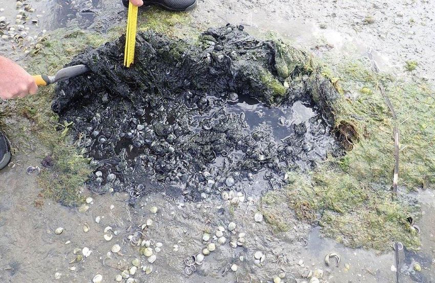
EXECUTIVE SUMMARY
BACKGROUND
As part of its State of the Environment programme, Greater Wellington Regional Council (GWRC) undertakes
monitoring and assessment of estuaries and other coastal environments in its region. A focus of GWRC’s work
has been in Te Awarua-o-Porirua Harbour, where monitoring over the last decade or longer has included ‘fine
scale’ and ‘broad scale’ surveys following methodologies described in New Zealand’s National Estuary
Monitoring Protocol (NEMP). This report describes an intertidal broad scale survey conducted in the harbour
in January 2020, which involved assessing the dominant substrate and vegetation features present in the
estuary including seagrass, salt marsh and macroalgae. Previous mapping results for 2008 and 2013 were
QAQC checked, updated to incorporate improvements in substrate classifications, and any errors in geometry
or typology were addressed. These updated results were then used to assess temporal changes.

KEY FINDINGS
The following table and bullet points summarise key broad scale monitoring results, and rates them using
preliminary criteria for assessing estuary health.
  Broad scale indicators                  Unit                                       2008            2013           2020
  Mud-dominated substrate                 % of intertidal area >50% mud               1.4            8.4             13.5
  Macroalgae (OMBT) 1                     Ecological Quality Rating (EQR)              na             na             0.71
  Seagrass2                               % decrease from baseline                    23.0           29.6            25.9
  Salt marsh extent (current)             % of intertidal area                        19.4           18.9            11.1
  Historical salt marsh extent            % of historical remaining3                  25.7           25.2            14.7
  200m terrestrial margin²                % densely vegetated                         19.3           17.0            23.3
  High Enrichment Conditions              ha                                           na             na             1.0
  High Enrichment Conditions              % of estuary                                 na             na             0.1
1
  OMBT=Opportunistic Macroalgal Blooming Tool. 2 Seagrass change assessed relative to baseline (64.9ha) derived from separate
surveys of Onepoto (1962) and Pauatahanui (1980). 3 Historic salt marsh change assessed relative to historic baseline (~200ha).

• There was a gradual increase in the spatial extent of mud-dominated sediment since 2008, particularly in
  the Pauatahanui arm. The 2020 spatial extent was rated ‘fair’, but approaching the ‘poor’ threshold of >15%.
• A harbour-wide reduction in opportunistic macroalgal growth was reported from 2017 to 2020 (details
  included in the main body of this report), and the presence of only small hotspots of persistent macroalgal
  in 2020, was rated ‘good’. However, conspicuous mats of filamentous green algae Chaetomorpha ligustica
  were present as drift material near the entrance in 2020, causing localised smothering of the seabed and
  its associated biota (e.g. seagrass, cockles).
• Seagrass was relatively extensive and has changed little in extent since 2008. It was rated ‘good’.
• A significant (43%) decline in salt marsh extent between 2013 and 2020, was rated ‘poor’. This was primarily
  in the eastern Pauatahanui arm where salt marsh is transitioning to terrestrially dominated vegetation as a
  consequence of ongoing drainage.
• Large historical losses of seagrass and salt marsh were rated ‘poor’.

RECOMMENDATIONS
Based on the findings of this report, it is recommended that GWRC consider the following:
• A further harbour-wide broad-scale survey in 5-years to keep track of long-term changes.
• Annual or biennial mapping or qualitative assessment of the northeast Pauatahanui arm to track changes
  in the spatial extent of the muddy sediment zone.
• Investigate the potential sources of recent and ongoing sediments to the Pauatahanui arm (e.g. examine
  recent and current land uses, determine mass loads from streams, undertake sediment tracing studies).
• Incorporate data from complementary monitoring, e.g. Transmission Gully data in future reporting.
• Assess the broader ecological implications of changes in key indicators revealed by the present report, and
  recent (fine scale) or planned (subtidal) surveys.
• Develop a strategy to minimise future losses of high value salt marsh including recommending specific
  restoration options, e.g. replanting salt marsh, improving tidal flushing, recontouring shorelines, and
  removing barriers to salt marsh expansion.

For the environment
Mō te taiao
1. INTRODUCTION                                                  Salt Ecology was contracted to carry out further
                                                                 NEMP broad scale and fine scale surveys in the
1.1     GENERAL BACKGROUND                                       harbour in January 2020. This report describes the
                                                                 methods and results of the broad scale survey,
Monitoring the ecological condition of estuarine                 compares findings with earlier intertidal NEMP
habitats is critical to their management. Estuary                surveys (2008, 2013) and earlier survey data (where
monitoring is undertaken by most councils in New                 available), and discusses the current status and
Zealand as part of their State of the Environment                trends in estuary health. Recommendations for
(SOE) programmes. The most widely-used                           future monitoring and assessment are also made.
monitoring framework is that outlined in New
Zealand’s National Estuary Monitoring Protocol
(NEMP, Robertson et al. 2002). The NEMP is intended
to provide resource managers nationally with a
scientifically    defensible,     cost-effective      and
standardised approach for monitoring the ecological
status of estuaries in their region. The results establish
a benchmark of estuarine health in order to better
understand human influences, and against which
future comparisons can be made. The NEMP
approach involves two main types of survey:
• Broad scale monitoring to map estuarine
  intertidal habitats. This type of monitoring is
  typically undertaken every 5 to 10 years.
• Fine scale monitoring of estuarine biota and
  sediment quality. This type of monitoring is
  typically conducted at intervals of 5 years after
  initially establishing a baseline.
Greater Wellington Regional Council (GWRC) has
undertaken monitoring of selected estuaries in the               Fig. 1 Location of Te Awarua-o-Porirua Harbour.
region using the NEMP methods and other
approaches (e.g. synoptic surveys, sedimentation
monitoring) for over a decade. A focus of GWRC’s
work has been in Te Awarua-o-Porirua Harbour (Fig.               1.2   BACKGROUND TO TE AWARUA-O-PORIRUA
1) where the first NEMP broad and fine scale surveys                   HARBOUR
were undertaken in 2008 (Robertson & Stevens 2008;               Background information on Te Awarua-o-Porirua
Stevens & Robertson 2008). Since then, GWRC has                  Harbour was most recently provided in the 2020 fine
commissioned follow-up and related surveys,                      scale report (Forrest et al. 2020) and is summarised
including:                                                       below.
• Two NEMP broad scale, and three fine scale                     The harbour is a large (807ha, Fig. 2), well-flushed
  surveys, most recently in 2013 and 2020,                       estuary fed by a number of small streams. It
  respectively (Stevens & Robertson 2013; Forrest et             comprises two arms, each a relatively simple shape,
  al. 2020).                                                     Onepoto (283ha) and Pauatahanui (524ha). The arms
• Targeted assessment of intertidal macroalgae, the              are connected by a narrow channel at Paremata, and
  most recent survey being in 2017 (Stevens &                    the estuary discharges to the sea via a narrow
  O’Neill-Stevens 2017).                                         entrance west of Plimmerton.

• Subtidal habitat mapping and ecological surveys                Residence time in the estuary is less than 3 days,
  (Milne et al. 2008; Oliver & Conwell 2014; Stevens             however, compared to the majority of New Zealand’s
  & Robertson 2014).                                             tidal lagoon estuaries which tend to drain almost
                                                                 completely at low tide, the harbour has a large
• Annual monitoring of sedimentation rates at                    shallow subtidal component (65%, mean depth
  intertidal and subtidal sites (e.g. Stevens & Forrest          ~1m). Nonetheless, the intertidal area is large
  2020a).                                                        (287ha).

For the environment
Mō te taiao                                                  1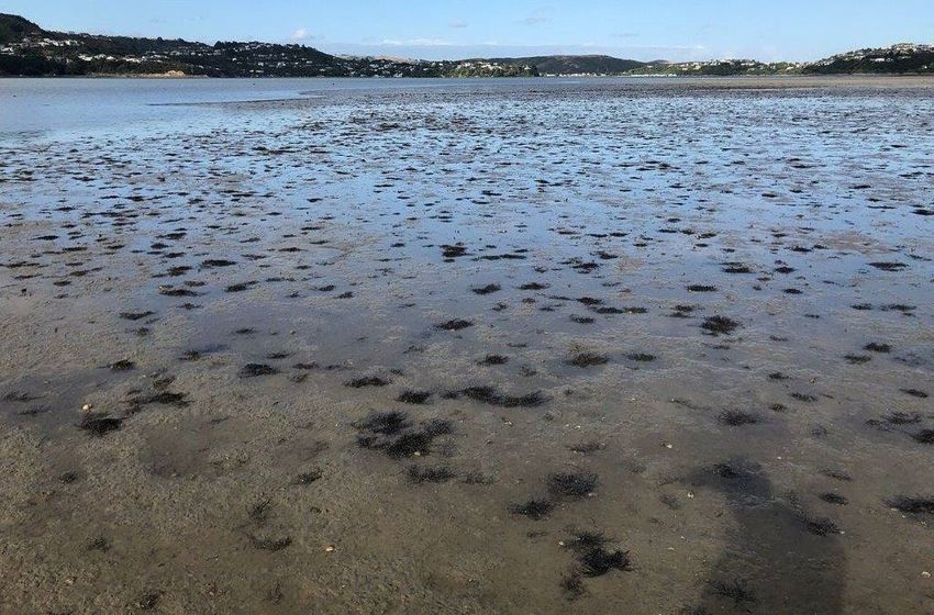
The estuary has high human use and high ecological           Table 1. Summary of catchment land cover
values. The last broad scale survey recorded                    (LCDB5 2018) for Te Awarua-o-Porirua Harbour.
extensive areas (59ha) of seagrass growing in firm
mud/sand, as well as shellfish beds (Stevens &                LCDB5 (2018) Class and Name                    Ha     %
Robertson 2013). Other studies have recorded very              1 Built-up Area (settlement)                 2463    14
high densities of cockles (Austrovenus stutchburyi)            2 Urban Parkland/Open Space                  387     2
across both arms of the harbour (e.g. Lyon & Michael           5 Transport Infrastructure                    78    0.5
2015, Michael & Wells 2017), with at least 43 fish             6 Surface Mine or Dump                        30    0.2
species and 53 bird species also recorded (Jones &            16 Gravel or Rock                               9    0.1
Hadfield 1985; Blaschke et al. 2010).                         20 Lake or Pond                                 7    0.0
                                                              22 Estuarine Open Water                        10    0.1
However, the harbour has been extensively modified            30 Short-rotation Cropland                      6    0.0
over the years, particularly the Onepoto arm, where           33 Orchard, Vineyard, Other Perennial Crop      2    0.0
almost all of the historical shoreline and salt marsh         40 High Producing Exotic Grassland            6468    38
have been reclaimed and most of the arm is now                41 Low Producing Grassland                    853     5
lined with steep straight rock walls flanked by road          45 Herbaceous Freshwater Vegetation            15    0.1
and rail corridors. The Pauatahanui arm is less               46 Herbaceous Saline Vegetation                44    0.3
modified (although most of the arm’s margins are              50 Fernland                                     1    0.0
also encircled by roads), with extensive areas of salt        51 Gorse and/or Broom                         1460    8
marsh remaining in the north and east. Many areas             52 Manuka and/or Kanuka                       596     3
have been improved through local community                    54 Broadleaved Indigenous Hardwoods           1745    10
enhancement efforts such as replanting near Porirua           64 Forest - Harvested                         112     1
Stream mouth, Kakaho and Horokiri.                            68 Deciduous Hardwoods                         16    0.1
                                                              69 Indigenous Forest                          251     1
Catchment land use in the Onepoto arm is
                                                              71 Exotic Forest                              2654    15
dominated by urban (residential and commercial)
                                                                  Grand Total                              17208   100
development (Table 1, Fig. 2). In the steeper
Pauatahanui arm, grazing is the dominant land use,
although urban (residential) development is
significant in some areas. Various reports have
identified sedimentation as a major problem in the
estuary, particularly in the Pauatahanui arm, where
potential sources include land disturbance
associated with urban subdivision (e.g. near Duck
Creek), and the Transmission Gully motorway
development (see Fig. 2).

                                                                                                           For the People
                                                         2                                                 Mō ngā tāngata
Fig. 1 Te Awarua-o-Porirua Harbour and surrounding catchment. For the environment Mō te taiao 3
2. BROAD SCALE METHODS                                                  seagrass (Zostera muelleri) and salt marsh, as well as
                                                                           vegetation of the terrestrial margin bordering the
   2.1     OVERVIEW OF MAPPING                                             harbour. Background information on the ecological
                                                                           significance of opportunistic macroalgae and the
   Broad-scale surveys involve describing and mapping                      different vegetation features is provided in Table 2.
   estuaries according to dominant surface habitat
   features (substrate and vegetation). This procedure                     In the field these broad scale habitat features were
   combines aerial photography, detailed ground                            drawn onto laminated aerial photographs. The
   truthing, and digital mapping using Geographic                          features were subsequently digitised into ArcMap
   Information System (GIS) technology. Once a                             10.6 shapefiles using a Wacom Cintiq21UX drawing
   baseline map has been constructed, changes in the                       tablet, and combined with field notes and
   position and/or size or type of dominant habitats can                   georeferenced photographs. From this information,
   be monitored by repeating the mapping exercise.                         habitat maps were produced showing the dominant
   Broad-scale mapping is typically carried out during                     substrate, macroalgae, seagrass and salt marsh, and
   September to May when most plants are still visible                     the vegetation and other features of the terrestrial
   and seasonal vegetation has not died back. Aerial                       margin.
   photographs are ideally assessed at a scale of less                     Estuary boundaries for mapping purposes were
   than 1:5000, as at a broader scale it becomes difficult                 based on the definition used in the New Zealand
   to accurately determine changes over time.                              Estuary Trophic Index (ETI; Robertson et al. 2016a)
   Broad scale mapping of Te Awarua-o-Porirua                              and are defined as the area between the estimated
   Harbour in 2020 used a combination of 2016 colour                       upper extent of saline intrusion (i.e. where ocean
   aerial photographs (~0.07m/pixel resolution)                            derived salts during average annual low flow are
   sourced from the LINZ data service, and more recent
2.2 SUBSTRATE ASSESSMENT 2.2.2 Sediment mud content and trophic status
Sediment mud content
2.2.1 Substrate mapping
The NEMP approach to substrate classification has A focus of substrate mapping is on documenting
been extended by Salt Ecology to record substrate changes in the area (horizontal extent) of intertidal
beneath vegetation (salt marsh, seagrass and muddy sediment. As a supporting indicator to this
macroalgae) to provide a continuous substrate layer broad scale measure, and to validate the subjective
for the estuary. Furthermore, the NEMP substrate sediment classifications used as part of the mapping
classifications themselves have been revised to method, mud content in representative sediment
provide a more meaningful classification of sediment samples was also determined by laboratory analysis.
based on mud content (Table 3, Appendix 1). Samples consisted of surface sediments (0-20mm
deep) collected with a trowel. For present purposes,
Under the original NEMP classification, mud/sand
samples were collected from 19 sites (14 intertidal, 5
mixtures can have a mud content ranging from 1-
subtidal) where sedimentation rate monitoring was
100% within the same class, and classes are
undertaken concurrently (Stevens & Forrest 2020b).
separated only by sediment firmness (how much a
Analytical methods are provided in Appendix 2.
person sinks), with increasing softness being a proxy
measure of increasing muddiness. Not only is sinking Sediment trophic status
variable between individuals (heavier people sink A subjective indication of the trophic status (i.e.
more readily than lighter people), but also in many extent of excessive organic or nutrient enrichment)
cases the relationship between muddiness and of soft sediment is provided by the depth of visible
sediment firmness does not hold true. Very muddy transition between oxygenated surface sediments
sediments may be firm to walk on, e.g. sun-baked (typically brown in colour) and deeper less
muds or muds deposited over gravel beds. In other oxygenated sediments (typically dark grey or black in
instances, soft sediments may have low mud colour). This transition is referred to as the apparent
contents, e.g. coarse muddy sands. Further, many of Redox Potential Discontinuity (aRPD) depth, and
the NEMP fine sediment classes have ambiguous provides an easily measured, time-integrated, and
definitions making classification subjective, or are relatively stable indicator of sediment enrichment
inconsistent with commonly accepted geological and oxygenation conditions.
criteria (e.g. the Wentworth scale).
To address these issues, mud and sand classifications
have been revised to provide additional resolution
based on the estimated mud content of fine-grained
substrates, with sediment firmness used as an
independent descriptor (Table 3, Appendix 1).
Lower-case abbreviations are used to designate
sediment firmness (f=firm, s=soft, vs=very soft).
Mobile substrate (m) is classified separately. Upper-
case abbreviations are used to designate four fine
unconsolidated substrate classes consistent with
existing geological terminology (S=Sand,
MS=Muddy Sand, SM=Sandy Mud, M=Mud). These
are based on sediment mud content (Table 3) and
reflect both biologically meaningful thresholds
where key changes in sediment macrofaunal
communities occur, and categories that can be
subjectively assessed in the field by experienced
Sediment trophic status is indicated by the depth of transition
scientists and validated by laboratory analyses. between oxygenated surface sediments (typically brown in colour)
Results of the validation analyses will be used to and deeper less oxygenated sediments (typically dark grey or black
refine the classification approach. in colour
In developing the revised classifications, care has
been taken to ensure that key metrics such as the
area of mud dominated habitat can be assessed
using both the NEMP and the revised classifications
so that comparisons with existing work can be made.
For the environment
Mō te taiao 5Table 2. Substrate classification codes used in the current report. As a supporting indicator of trophic status in Te Water Framework Directive (WFD-UKTAG 2014)) Awarua-o-Porirua Harbour, aRPD was assessed in Opportunistic Macroalgal Blooming Tool (OMBT) for representative areas by digging into the underlying macroalgal assessment. The OMBT, described in sediment with a hand trowel to determine whether detail in Appendix 3, is a five-part multi-metric index there were any significant areas where sediment that provides a comprehensive measure of the oxygenation was depleted close to the surface. combined influence of macroalgal growth and Sediments were considered to have poor distribution in an estuary. It produces an overall oxygenation if the aRPD was consistently
• Extent of algal entrainment into the sediment              the OMBT method. Using the macroalgal cover and
  matrix: Macroalgae was defined as entrained                biomass data, macroalgal OMBT scores were
  when growing >30mm deep within sediments,                  calculated using the WFD-UKTAG Excel template.
  which indicates that persistent macroalgal                 The scores were then categorised on the five-point
  growths have established.                                  scale adopted by the method, for which descriptors
                                                             range from ‘high’ to ‘bad’.
If an estuary supports 50%.
Within      these     percent    cover     categories,       The 50% threshold was used as it was assumed that
representative patches of comparable macroalgal              previous NEMP mapping recorded seagrass beds
growth were identified and the biomass and the               when present as moderate to complete cover (i.e.
depth of macroalgal entrainment were measured.               cover >50%), noting that it is also difficult to
Biomass was measured by collecting algae growing             distinguish seagrass cover of
of dominance with subdominant species placed in in the GIS attribute tables with any changes shown
parentheses, e.g. Jukr(Caed) indicates that sea rush alongside. In addition, detailed metadata describing
was dominant over ice plant (Carpobrotus edulis). A data sources and any changes made have been
relative measure of vegetation height can be derived provided with each GIS layer and supplied to GWRC.
from its structural class (e.g. rushland is taller than
During the field ground-truthing, sediment grain size
herbfield).
and macroalgal data were recorded in electronic
As well as generating summaries (e.g. maps, tables) templates custom-built using Fulcrum app software
of salt marsh type and extent in 2020 relative to other (www.fulcrumapp.com). Pre-specified constraints on
years, two additional measures were used to assess data entry (e.g. with respect to data type, minimum
salt marsh condition: i) Intertidal extent (percent or maximum values) ensured that the risk of
cover), and ii) Current extent compared to estimated erroneous data recording was minimised. Each
historical extent. sampling record created in Fulcrum generated a GPS
position, which was exported to ArcMAP. Macroalgal
2.6 TERRESTRIAL MARGIN ASSESSMENT OMBT scores were calculated using the WFD-UKTAG
The 200m terrestrial margin surrounding the estuary Excel template.
was mapped and classified using the dominant land
cover classification codes described in the Landcare 2.8 ASSESSMENT OF ESTUARY CONDITION AND
Research Land Cover Data Base (LCDB5). Classes are TEMPORAL CHANGE
shown in Fig. 2 and detailed in Appendix 1. Broad-scale results are used primarily to assess
estuary condition in response to common stressors
2.7 DATA RECORDING, QA/QC AND ANALYSIS
such as fine sediment inputs, nutrient enrichment or
Broad scale mapping is intended to provide a rapid habitat loss. In addition to the authors’ interpretation
overview of estuary condition. The ability to correctly of the data, results are assessed within the context of
identify and map features is primarily determined by established or developing estuarine health metrics
the resolution of available aerial photos, the extent of (‘condition ratings’), drawing on approaches from NZ
ground truthing undertaken to validate features and overseas (Table 4). These metrics assign different
visible on photographs, and the experience of those indicators to one of four colour-coded ‘health status’
undertaking the mapping. In most instances features bands, as shown in Table 4. The condition ratings are
with readily defined edges such as rushland, primarily sourced from the NZ ETI (Robertson et al.
rockfields, dense seagrass, etc. can be mapped at a 2016b). Additional supporting information on the
scale of ~1:2000 to within 1-2m of their boundaries. ratings is provided in Appendix 4. To avoid confusion,
The greatest scope for error occurs where boundaries note that the condition rating descriptors used in the
are not readily visible on photographs, e.g. sparse four-point rating scale in the ETI (i.e. between ‘very
seagrass beds, or where there is a transition between good’ and ‘poor’) differ from the five-point scale for
features that appear visually similar, e.g. sand, muddy macroalgal OMBT EQR scores (i.e. which range from
sand, mud. Extensive mapping experience has ‘high’ to ‘bad’.
shown that transitional boundaries can be mapped As a supporting measure for the broad scale indicator
to within ±10m where they have been thoroughly of mud-dominated sediment extent (areas >50%
ground truthed, but accuracy is unlikely to be better mud), we also consider the ‘mud-elevated’ (>25%
than ±20-50m for such features when relying on mud) sediment component, as this is the threshold
photographs alone. above which ecological communities can become
In 2020, following digitising of habitat features, in- degraded (hence the sediment quality rating of
house scripting tools were used to check for ‘poor’ in Table 4).
duplicated or overlapping GIS polygons, validate As an integrated measure of the combined presence
typology (field codes) and calculate areas and of indicators which may result in adverse ecological
percentages used in summary tables. Using these outcomes, the occurrence of High Enrichment
same tools, the 2008 and 2013 GIS layers were Conditions (HEC) was evaluated. HECs are referred to
similarly checked for any errors in basic geometry alternatively as ‘Gross Eutrophic Zones’ (GEZs) in the
(e.g. overlapping polygons), and updated to fix any ETI (Zeldis et al. 2017).
identified issues. For our purposes HECs are defined as mud-
In addition, the substrate types were updated to dominated sediments (≥50% mud content) with
reflect the revised classifications presented in Table 3. >50% macroalgal cover and with macroalgae
The original classification codes have been retained entrained (growing >30mm deep) within the
For the People
8 Mō ngā tāngatasediment. HECs can also be present in non-algal As many of the scoring categories in Table 4 are still
areas where sediments have an elevated organic provisional, they should be regarded only as a
content (>1% total organic carbon) combined with general guide to assist with interpretation of estuary
low sediment oxygenation (aRPD 50% mud 5-15 > 15
Macroalgae (OMBT)¹ Ecological Quality Rating (EQR) ≥ 0.8 - 1.0 ≥ 0.6 - < 0.8 ≥ 0.4 - < 0.6 0.0 - < 0.4
Seagrass² % decrease from baseline3. RESULTS AND DISCUSSION problematic mud fraction, ~45% (118.3ha) of the tidal
flat area had a sediment mud content of >25% (Fig.
The 2020 broad scale results are summarised in the 5). Of this component, 31.9ha were mud-dominated
following sections, with the supporting GIS files (i.e. excessively muddy) sediments (>50-90% mud
(supplied as a separate electronic output) providing content), which represents 12% of the total intertidal
a more detailed data set designed for easy area (Fig. 5). Preliminary screening revealed an aRPD
interrogation and to address specific monitoring and depth shallower than 5-10mm depth in the locations
management questions. with the muddiest sediments (Appendix 5), or where
there was a dense cover of macroalgae (see Section
3.1 INTERTIDAL SUBSTRATE 3.2).
Results from the 2020 survey in Table 5 and Fig. 4 A comparison of the three broad scale surveys
show that substrate in the harbour is relatively conducted to date reveals a steady increase in the
heterogeneous across the mapped intertidal area of spatial extent of mud-dominated sediment over a 12-
~265ha. Example photographs of representative year period, i.e. from 3.4ha recorded in 2008 to almost
substrates are provided below and on following 32ha in 2020 (see Fig. 5 inset). Most of the mud-
pages. Validation of 19 subjective sediment substrate dominated sediments occur in the eastern and
classifications showed that 16 observations were northern Pauatahanui arm of the harbour. Key areas
assigned to the correct mud content class (Appendix are the Kakaho and Horokiri Stream deltas, and
5). In three instances the field classification alongside Ration Point near the Pauatahanui Stream
overestimated actual mud content due to a thin layer delta. In the Kakaho and Horokiri areas in particular,
of muddy sediment deposited on top of a relatively there was relatively fresh muddy surface sediment
coarse (primarily sandy) base. Hence, the substrate overlying the base of firm muddy sand present in
patterns described below can be considered a previous surveys. This surface material could be
reliable representation of surface sediment scraped aside like a muddy ‘slurry’ (see photos
conditions. below).
In 2020, substrates were dominated by firm muddy
sands. In terms of the biologically relevant
Table 4. Summary of dominant intertidal substrates.
Subclass Dominant feature Ha %
Artificial Artificial substrate 2.0 0.7
Bedrock Rock field 4.9 1.8
Boulder/Cobble/Gravel Boulder field 0.1 0.0
Artificial boulder field 0.6 0.23
Cobble field 4.2 1.6
Artificial cobble field 0.1 0.05 Layer of recent soft mud overlying firm muddy sand, Horokiri
Gravel field 25.1 9.4
Sand Mobile sand 10.1 3.8
(0-10% mud) Firm sand 23.6 8.9
Muddy Sand Firm muddy sand 74.0 27.9
(>10-25% mud)
Muddy Sand Firm muddy sand 84.6 31.9
(>25-50% mud) Soft muddy sand 1.8 0.7
Sandy Mud Firm sandy mud 6.0 2.3
(>50-90% mud) Soft sandy mud 21.4 8.1
Very soft sandy mud 4.5 1.7
Zootic Shell bank 2.3 0.9
Cocklebed 0.01 0.003
Tubeworm reef 0.04 0.01
Total 265.2 100
Eroding soft mud deposits overlying firm muddy sand, upper
Pauatahanui arm
For the People
10 Mō ngā tāngataFig. 3 Map of dominant intertidal substrate types, Te Awarua-o-Porirua Harbour January 2020. For the environment Mō te taiao 11
Fig. 4 Map of intertidal substrate types showing area of mud-elevated (>25-50% mud) and mud-
   dominated (>50% mud) sediment, Te Awarua-o-Porirua Harbour January 2020. Inset bar graph
   shows change in mud-dominated sediments since 2008, not including areas within salt marsh (see
   text for explanation).

                                                                                         For the People
                                                12                                       Mō ngā tāngata
Typical upper tidal gravel field and narrow Typical firm muddy sand tidal flats Resuspension of muddy sediment layer,
strip of salt marsh Kakaho
Firm muddy sands near Porirua Stream Soft muddy sand at Horokiri Shell bank in central Pauatahanui arm
mouth
Gravel and shell bank in the upper Rippled mobile sand in the lower Onepoto Sarcocornia among gravel fields in eastern
Pauatahanui arm arm Pauatahanui arm
Natural bedrock was most prevalent in Orange sea sponge among biogenic Modified margin with restoration planting,
outer harbour areas habitat provided by tube worm reef Paremata railway
Modified margin of eastern Onepoto arm Rip rap wall in western Onepoto arm Eroding margin along Titahi Bay Road,
western Onepoto
For the environment
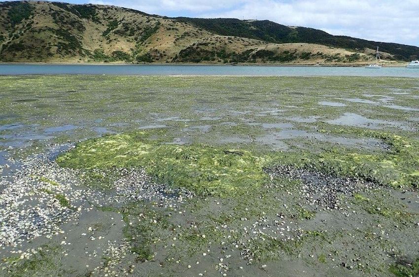
Mō te taiao 13Note that the temporal comparison excludes arm, and the Te Onepoto Stream embayment. The
sediment within salt marsh areas, as this was not key features of these areas were as follows:
recorded in 2008 or 2013. Also, it has been assumed
Te Onepoto Stream embayment had an extensive
that the NEMP classifications for soft mud and very
cover (70-90%) and the greatest biomass (>3kg/m2)
soft mud used in the earlier surveys reflect mud-
of macroalgae, consisting primarily of Gracilaria
dominated sediments (>50% mud content), and that
chilensis and lesser amounts of a filamentous green
firm muddy sands reflect sediments with mud
seaweed, recently identified by NIWA as
contents of 10-25%. This assumption is necessary as
Chaetomorpha ligustica
earlier NEMP surveys did not provide the detailed
sediment classifications used in 2020 (see Table 3). In the southern Onepoto arm, Gracilaria was
conspicuous, with small patches of dense cover (70-
While the sediment in the Horokiri and Kakaho areas
90%) around the Wi Neera Drive boat ramp and
often remained firm to walk on, the extensive
adjacent stormwater outfall.
presence of relatively deep surface mud is likely to
have significantly adversely impacted the sediment Along the Paremata railway flats and Mana area, one
dwelling communities present, while the associated of the conspicuous features was extensive mats of
infilling of interstitial spaces is likely to have shifted Chaetomorpha ligustica, which appeared to mainly
the macrofaunal community to one that is less be drift (unattached) material. The Paremata railway
diverse and dominated by mud-tolerant species. flats area also had sparser areas of Ulva and Gracilaria
However, it is unclear whether this state will persist, (see photos).
as there was evidence during the field survey of the While Gracilaria and Ulva are well-recognised
muddy surface layer being eroded and remobilised opportunistic species, Chaetomorpha ligustica
(see photos). belongs to a poorly understood seaweed group with
In addition to these muddy or sandy soft sediments, a disjointed distribution in New Zealand. It appears to
other less prevalent but ecologically important be the same species described as being present in Te
habitats across the harbour included gravel fields and Awarua-o-Porirua Harbour since the 1950’s (Adams
hard natural substrates (bedrock, boulder, cobble) 1994), although anecdotally has become more
around the harbour margins, representing ~13% of conspicuous in recent years. For example, these mats
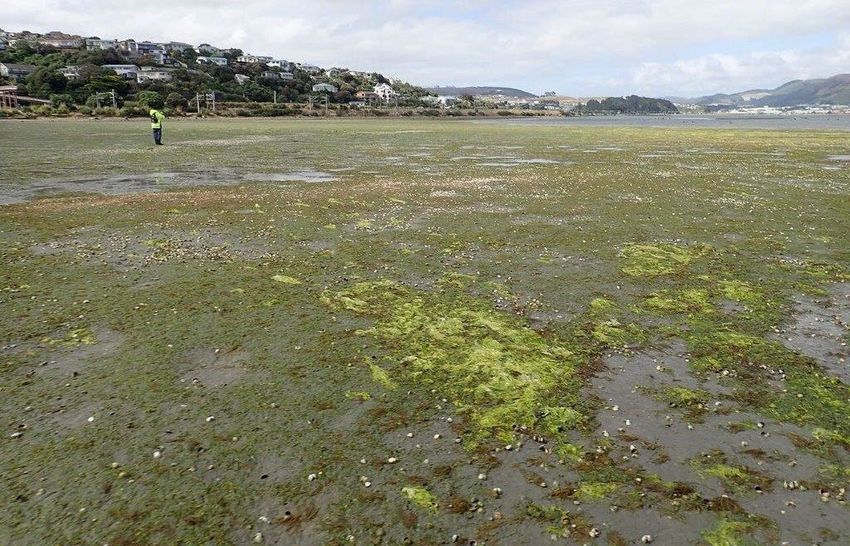
the mapped intertidal area. Minor habitats (Fig. 5 Distribution and percentage cover classes of opportunistic macroalgae, Te Awarua-o-Porirua
Harbour January 2020.
For the environment
Mō te taiao 15Fig. 6 Biomass (wet weight g/m2) classes of opportunistic macroalgae, Te Awarua-o-Porirua Harbour
January 2020.
For the People
16 Mō ngā tāngataGracilaria was the most widespread macroalgae but was typically Problem growths of Gracilaria in the Te Onepoto Stream at low prevalence embayment Drift (unattached) Chaetomorpha mats around Mana boatshed Chaetomorpha drift mats among cockles on Paremata railway flats area Broad-bladed Ulva (aka ‘sea lettuce’) was most prevalent in gravel Ulva, Chaetomorpha and Gracilaria among seagrass on Paremata and cobble areas railway flats Chaetomorpha mats had a smothering effect leading to High biomass beds of Gracilaria were entrained into the sediment sediment anoxia and killing organisms beneath with anoxic sediments beneath For the environment Mō te taiao 17
The OMBT input metrics and overall macroalgal EQR             monitoring of macroalgal status is worthwhile
for 2020 are provided in Table 7. The overall EQR             despite the overall improvement in EQR in 2020.
calculated using the OMBT method was 0.71, which
equates to a rating of ‘good’ according to the Table 4
                                                              Table 8. Summary of EQR scores for the four most
criteria.
                                                                 macroalgal surveys in Te Awarua-o- Porirua
Data from previous macroalgal surveys (2008-2017)                Harbour.
are summarised by Stevens and O’Neill-Stevens
(2017), with EQR scores having being calculated since              Year                    EQR                  Rating
2015. These scores are provided in Table 8. As for                 2015                    0.58                Moderate
2020, the EQR was rated as ‘good’ in 2016, whereas it              2016                    0.61                 Good
2015 and 2017 the rating was ‘moderate’. Stevens
                                                                   2017                    0.55                Moderate
and O’Neill-Stevens (2017) noted the presence in
                                                                   2020                    0.71                 Good
2017 of high density intertidal macroalgal growths
on the verge of nuisance conditions. They described
a doubling of macroalgal biomass between the 2016
and 2017 surveys, with the most notable increases
being on the Pauatahanui, Kakaho and, to a lesser
extent, Horokiri stream deltas. Data provided in their
2017 survey report indicate a biomass of up to
2kg/m2 in the eastern end of the Pauatahanui arm,
and typically 0.2-0.5kg/m2 in the Horokiri and Kakaho
area. By contrast, in 2020 the spatial extent of
macroalgae was much reduced in those areas, and
high biomass beds were absent (biomass in 2020 was
3.3 SEAGRASS is likely to have been significantly larger. In more
recent years, overall seagrass cover has fluctuated,
Table 9 summarises intertidal seagrass (Zostera
and in fact was slightly greater in 2020 than in the
muelleri) cover in 2020, with the distribution shown
earlier 2013 survey. This reflects a contraction in cover
in Fig. 8.
on the flats around Paremata railway (which appears
Intertidal seagrass beds are extensive across parts of due to smothering by Chaetomorpha) but an
both arms of the harbour, especially in outer areas, expansion of the bed in Brown’s Bay. While some
with a total mapped area of ~60ha in 2020. Of this temporal changes may reflect variability in the
total, 48ha was categorised as being at least mapping accuracy between different observers, in
‘moderate’ density (≥30% cover), of which 32ha was particular delineation of the intertidal-subtidal
in the Pauatahanui arm. In that arm, dense beds (70- interface, overall the reported broad scale results are
90% cover) existed next to Mana and on the mid-arm considered to be a true reflection of sea grass extent
intertidal banks. A notable feature of these banks was and change over time
an extensive area of bleached seagrass fronds (see
adjacent photo), although the bottom sections of the
fronds appeared to be unaffected. By contrast, beds Table 9. Summary of intertidal seagrass cover
in Brown’s Bay and Bradey’s Bay, while relatively small, classes, Te Awarua-o-Porirua Harbour Jan 2020.
had the most complete (>90%) cover and showed no
signs of bleaching. Percent cover category Ha %
Absent or Trace (Fig. 7 Distribution and percentage cover classes of seagrass, Te Awarua-o-Porirua Harbour January 2020.
Inset bar graph shows change in seagrass cover ≥50% from baseline of 64.9ha. The baseline
represents the combined area from separate historic surveys of Onepoto and Pauatahanui arms
(1962 Onepoto, 1980 Pauatahanui; see Table 10).
For the People
20 Mō ngā tāngataTable 6. Summary of changes in seagrass area (ha) from baseline measures in 1962 (Onepoto) and
1980 (Pauatahanui) based on areas where % cover exceeded the ‘moderate’ threshold of ≥50%.
Pauatahanui 1980 2008 2013 2020
Mana 1.2 4.3 4.3 6.1
Camborne 0.2 0 0 0
Kakaho 6.2 0 0 0
Ration Point (head of arm) 26 0 0 0
Duck Creek 0.2 0 0 0
Bradey's Bay 0.2 1.4 1.4 1.6
Browns Bay 0 0.9 0.9 2.5
Ivey Bay-Morehouse Point 2.7 4.4 4.2 2.8
Mid harbour 0 19.1 17.3 19.39
Pauatahanui seagrass >50% cover (ha) 36.7 30.1 28.1 32.2
% Reduction from baseline - 18 23 12
Onepoto 1962 2008 2013 2020
Western entrance 1.8 4.2 4.2 3.5
Mana marina 3.1 0 0 0
Railway 14.8 14.1 11.9 11.5
Upper Onepoto 8.5 1.6 1.5 0.9
Onepoto seagrass >50% cover (ha) 28.2 19.9 17.6 15.9
% Reduction from baseline 29 38 44
Total Harbour 1962/1980 2008 2013 2020
Total seagrass >50% cover (ha) 64.9 50.0 45.7 48.1
% Reduction from baseline - 23 30 26
Note: Historic data derived from 2013 broad-scale survey report (Stevens & Robertson 2013, and references therein).
Seagrass on Paremata railway flats Seagrass in Bradey’s Bay
For the environment
Mō te taiao 213.4 SALT MARSH
Table 11 summarises intertidal salt marsh subclasses
and cover for the three NEMP surveys, with the
mapped distribution in 2020 shown in Fig. 9. Detail
regarding the dominant and subdominant species
recorded in 2020 is provided in Appendix 6.
A total of 29.3ha of salt marsh was recorded from the
estuary in 2020. Of this, 28.7ha (98%) was located in
the Pauatahanui arm, with just 0.6ha (2%) in the
Onepoto arm. The salt marsh is dominated by
rushland (21ha, 8.2% of the intertidal area), estuarine
shrubs (5.9ha, 2.2%) and herbfield 1ha, 0.4%).
Rushland comprised mainly searush (Juncus kraussii)
and jointed wire rush (Apodasmia similis) which, as
the terrestrial influence increased, transitioned
through areas dominated by saltmarsh ribbonwood
(Plagianthus divaricatus) and grassland (mostly tall
fescue, Festuca arundinacea). Within the rushland and
grassland vegetation subclasses, a wide variety of
common estuarine plants were present (Appendix 6),
with introduced weeds a common subdominant
cover, particularly among the grassland. Herbfields, The upper Pauatahanui is largely cut off from tidal flows and is
extensively drained resulting in salt marsh becoming increasingly
dominated by glasswort (Sarcocornia quinqueflora), terrestrially dominated
were also common on raised shell banks at the upper
tidal zone in the north and east.
The relatively small area of salt marsh in the harbour
reflects historic and ongoing modification. At the
time of the 2013 survey, it was estimated that there
had been an historic salt marsh loss of 50% from the
Pauatahanui arm and 99% from the Onepoto arm,
(Stevens & Robertson 2013), with an estimated
historic total harbour-wide salt marsh loss of ~200ha.
The loss from the Onepoto will reflect extensive
reclamation undertaken in that arm (Blaschke et al.
2010; Dahm & Gibberd 2019). However, across the
harbour generally, creation of artificial margins (e.g. Salt marsh was dominated by rushland,- dense searush (Juncus
kraussii) and sparse tall fescue behind a shell ridge near Kakaho
rock walls) around the perimeter have also displaced
much of the historical salt marsh cover.
The 2008 NEMP survey appears to be the first
comprehensive assessment of salt marsh habitat.
Table 11 shows that the area of salt marsh remained
stable from 2008 to 2013 at just over 50ha, but there
has been a subsequent decline to ~29ha in 2020. This
decline is primarily a reflection of a reduced area of
estuarine shrub, grassland and rushland in the
Pauatahanui arm. While much of this vegetation
remains, it is now largely cut off from tidal flows and
criss-crossed with drainage channels and bunds to
the extent that the upper reaches are transitioning to
terrestrially dominated vegetation. An example of Herbfield (primrose and glasswort) and rushland (sea rush) near
this is shown in the following photograph Ration Point
For the People
22 Mō ngā tāngataTable 11. Summary of temporal change in salt
marsh area (ha), showing % reduction since
2008.
Subclass 2008 2013 2020
Tussockland 1.2 0.7 0.5
Sedgeland 0 0 0.002
Grassland 7.9 7.7 0.04
Rushland 29.4 29 21.8
Reedland 0.6 0.5 0.1
Herbfield 1.1 1.3 1.0
Total area (ha) 51.5 50.2 29.3
% Reduction - 3 43
Terrestrial restoration plantings in the embayment between the road
and rail corridors where the two arms of the estuary meet
One of the visible changes occurring in the estuary is
the effort being put into salt marsh restoration by the
community, Department of Conservation, Porirua
City Council and GWRC. These efforts include the
ongoing development of a boardwalk around the
Pauatahanui arm which is re-establishing public
access to the estuary margin previously cut off in
many places by roads that flank much of the estuary
(photo below).
Shared pathway separating the road from the estuary in the eastern
Pauatahanui arm. Small areas of saltmarsh on the right
Elsewhere margin plantings are evident in many
locations. Because of the greatly reduced cover of
saltmarsh, even small areas of restoration have the
potential to substantially increase the extent and
quality of saltmarsh in the estuary. This is particularly
so in the Onepoto arm where recent planning
initiatives led by PCC and GWRC have sought to
identify priority areas for restoration. These include Narrow band of glasswort growing within the artificial boulder walls
margins near the Porirua Stream mouth, Motukaraka near Porirua Stream mouth (top) and adjacent to Titahi Bay Road
(bottom)
Point, and along Wi Neera Beach and Titahi Bay Road.
For the environment
Mō te taiao 23Fig. 8 Distribution and type of saltmarsh, Te Awarua-o-Porirua Harbour January 2020.
For the People
24 Mō ngā tāngata3.5 TERRESTRIAL MARGIN well utilised in these areas, but roading still presents
a significant barrier to public access to the estuary.
Mapping of the 200m wide terrestrial margin (Table
12, Fig. 10) in 2020 confirmed previous survey The northern and eastern margin of Pauatahanui
findings, which showed that most of the immediate remains relatively undeveloped grassland (grazed
estuary margin has been modified by roading, pasture), with a few pockets of scrub/forest and
causeways, seawalls, or reclamations. In 2020, the residential development. Grassland adjacent to the
margin was dominated by built-up area (35.0%), estuary generally contained a range of introduced
grassland (22.2%) and native scrub/broadleaved weeds. Overall, the terrestrial margin is dominated by
indigenous hardwoods (19.7%). The latter was artificial structures, residential, and commercial or
primarily located within Whitireia Park in the industrial developments, and grazed pasture. As a
northwest of the Onepoto arm, and in pockets consequence of this significant past development, it
among residential areas in Pauatahanui arm. retains very few unmodified habitat features that are
in their natural state.
Approximately 23% of the margin was classified as
densely vegetated, which is an aggregation of LCDB
classes 45-69. The extent of densely vegetated
terrestrial buffer fits the condition rating of ‘poor’,
with no significant change from 2008.
Table 12. Terrestrial margin features in 2020.
LCDB5 Class and name %
1 Built-up Area (settlement) 35.0
2 Urban Parkland/Open Space 8.6
5 Transport Infrastructure 9.7
16 Gravel and Rock 0.4
20 Lake or Pond 0.6
21 River 0.2
41 Low Producing Grassland 22.2 Accumulation of organic material and litter near Porirua Stream
45 Herbaceous Freshwater Vegetation 1.3 mouth
46 Herbaceous Saline Vegetation 0.03
54 Broadleaved Indigenous Hardwoods 19.7
56 Mixed Exotic Shrubland 0.0
69 Indigenous Forest 2.2
Total 100
The extensive presence of road and rail corridors
directly bordering about two-thirds of each arm of
the estuary greatly impinges upon the aesthetic and
natural values of the estuary, and breaks the natural
sequence of estuarine to terrestrial vegetation. This is Wooden seawall on the Mana flats
most pronounced in the Onepoto arm where small
remnant, poorly-flushed estuary embayments are cut
off from the main body of the estuary, e.g. Aotea
Lagoon. The reclaimed areas of railway and
motorway are dominated by introduced weeds and
grass. Accumulations of rubbish from Porirua
continue to be a feature of the Onepoto arm (see
following photo). Whitireia Park continues to recover
well from the fire that destroyed much of the scrub
cover in 2010. Residential areas in the north west and
south of Pauatahanui arm are notable for the
scrub/forest corridors remaining among the housing Vertical wooden seawall and vehicle access route on the southern
and bordering the estuary. Public access tracks are side of the Pauatahanui arm
For the environment
Mō te taiao 25Fig. 9 Distribution and classes (LCDB5 20018) of vegetation in the 200m terrestrial margin, Te Awarua-o-
Porirua Harbour January 2020.
For the People
26 Mō ngā tāngata4. SYNTHESIS AND necessary as the 2008 and 2013 surveys did not
assess sediment type within salt marsh habitats.
RECOMMENDATIONS
Table 14 highlights that there have been significant
4.1 Synthesis of key findings losses of seagrass and salt marsh relative to estimated
historic conditions, giving a ‘poor’ rating for these
This report has described a broad scale habitat assessment indicators. In recent years seagrass has
mapping and assessment survey of Te Awarua-o- been relatively stable, and the salt marsh rating has
Porirua Harbour, largely following the broad scale not changed. However, there has nonetheless been
survey methods described in New Zealand’s NEMP. a significant (43%) decline in remnant salt marsh
A summary of key broad scale features measured in extent between 2013 and 2020. The latter was
2020 is provided in Table 13. In Table 14 these discussed above in relation to the eastern
indicators are assessed in relation to the condition Pauatahanui arm which is largely cut off from tidal
rating criteria in Table 4 and compared with other flows and criss-crossed with drainage channels and
years. Note that, to enable comparison across years, bunds to the extent that the upper reaches are
the mud-dominated substrate rating in Table 14 was transitioning to terrestrially dominated vegetation.
assessed as a percentage of the intertidal area One of the key indicators of estuary health in
excluding salt marsh (235.9ha) rather than the total unvegetated areas is the extent of muddy sediment.
intertidal area of 265.2ha. This adjustment was The 2020 survey has revealed a gradual increase in
the spatial extent of mud-dominated sediment since
Table 7. Summary of broad scale indicators, Te Awarua-o-Porirua Harbour 2020.
Component Ha % Harbour %Intertidal %Salt marsh %Margin
Area
Harbour area 785.9 100
Intertidal area 265.2 33.7
Subtidal area (not assessed) 520.7 66.3
Substrate
Mud-elevated sediment (>25% mud) 118.2 15.0 44.6
Mud-dominated sediment (>50% mud) 31.9 4.1 12.0
Nuisance Macroalgae
Macroalgal beds (≥50% cover) 1.2 0.2 0.5
Seagrass
Seagrass (≥50% cover) 48.0 6.1 18.1
Saltmarsh
Estuarine shrub 5.9 0.7 2.2 20.0
Tussockland 0.5 0.1 0.2 1.6
Sedgeland 0.002 0.0 0.0 0.01
Grassland 0.04 0.0 0.0 0.1
Rushland 21.8 2.8 8.2 74.4
Reedland 0.1 0.0 0.0 0.4
Herbfield 1.0 0.1 0.4 3.4
Total 29.3 3.7 11.1 100
200m Terrestrial margin
%densely vegetated (LCDB classes 45-71) 23.3
For the environment
Mō te taiao 27You can also read