Characteristics and influencing factors of rainfall-induced landslide and debris flow hazards in Shaanxi Province, China
←
→
Page content transcription
If your browser does not render page correctly, please read the page content below
Nat. Hazards Earth Syst. Sci., 19, 93–105, 2019
https://doi.org/10.5194/nhess-19-93-2019
© Author(s) 2019. This work is distributed under
the Creative Commons Attribution 4.0 License.

Characteristics and influencing factors of rainfall-induced landslide
and debris flow hazards in Shaanxi Province, China
Ke Zhang1 , Sheng Wang1 , Hongjun Bao2 , and Xiaomeng Zhao3
1 StateKey Laboratory of Hydrology-Water Resources and Hydraulic Engineering, and College of Hydrology and Water
Resources, Hohai University, Nanjing, Jiangsu, 210098, China
2 National Meteorological Center, China Meteorological Administration, Beijing, 100081, China
3 Shaanxi Climate Center, Xi’an, Shaanxi, 710014, China

Correspondence: Ke Zhang (kzhang@hhu.edu.cn) and Hongjun Bao (baohongjun@cma.gov.cn)

Received: 9 September 2018 – Discussion started: 12 September 2018
Accepted: 19 December 2018 – Published: 14 January 2019

Abstract. Shaanxi Province, located in northwest China and           1   Introduction
spanning multiple hydroclimatic and geological zones, has
many areas largely suffering from rainfall-induced landslide         Landslides and debris flows are two widespread and de-
and debris flow. The objectives of this study are to reveal the      structive natural hazards around the world (Peruccacci et al.,
spatiotemporal characteristics of the two hazards and iden-          2012; Huang et al., 2017; Nicolussi et al., 2015; Blothe et
tify their major controlling factors in this region based on a       al., 2015; Wooten et al., 2008; Hong et al., 2007), which
region-wide, comprehensive ground-survey-based hazard in-            can cause large casualties and economic losses (Jaboyedoff
ventory dataset from 2009 to 2012. We investigated the spa-          et al., 2012; Hong et al., 2017b; Zhang et al., 2016). Globally,
tiotemporal characteristics of the two hazards and quantified        landslides are responsible for approximately 1000 deaths and
the relationships between the occurrence rates of the two haz-       about USD 4 billion in property losses per year (Pradhan
ards and their influencing factors, including antecedent rain-       and Youssef, 2010). Landslide-caused fatalities accounted
fall amount, rainfall duration, rainfall intensity, terrain slope,   for 17 % of fatalities due to natural hazards (H. Y. Hong et
land cover type and soil type. The results show that land-           al., 2015). For debris flows, it is more difficult to quantify the
slide has a higher occurrence rate and more extensive distri-        resultant casualties and damages because it is hard to distin-
bution than debris flow in this region, while the two hazards        guish debris-flow-induced losses from the losses caused by
are both concentrated in the south with ample rainfall and           concurrent flood or other hazards (Borga et al., 2014). China
steep terrains. Both of the hazards show clear seasonalities:        is severely affected by geological disasters, including land-
July–September for landslide and July for debris flow. Rain-         slide and debris flow (Petley, 2010; H. Y. Hong et al., 2015).
fall characteristics (amount, duration and intensity) and slope      Statistical reports by the Chinese Institution of Geological
are the dominant factors controlling slope stability across this     Environmental Monitoring showed that unexpected geolog-
region. Debris flow is more sensitive to these rainfall metrics      ical hazards lead to 1167 casualties and CNY 6.4 billion in
on the high-value ranges than landslide in this region. Land         property losses per year (Zhang et al., 2017). Other research
cover is another influencing factor but soil type does not ap-       reported that landslide disasters have caused about 1100 fa-
pear to impose consistent impacts on the occurrence of the           talities and USD 5–10 billion in China since 2000 (Hong et
two hazards. This study not only provides important inven-           al., 2017a).
tory data for studying the landslide and debris flow hazards            Due to the massive casualties and property damages that
but also adds valuable information for modeling and predict-         landslide and debris flow may cause, it is essential to have a
ing the two hazards to enhance resilience to these hazards in        profound comprehension of the causes, e.g., heavy rainfall,
this region.                                                         earthquakes and human activities, of these disasters (Chen
                                                                     et al., 2015b). Landslide occurrence is a complex nonlinear
                                                                     process (Qin et al., 2001; Sorbino et al., 2010) that is influ-

Published by Copernicus Publications on behalf of the European Geosciences Union.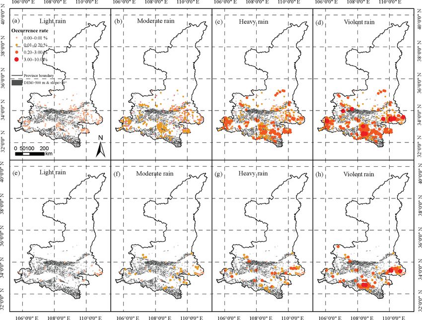
94                                     K. Zhang et al.: Characteristics and influencing factors of rainfall-induced landslide

enced by many different factors such as geological features         ards. To this end, we firstly compiled an inventory data of
and hydrological conditions (Zhu et al., 2017). In many re-         rainfall-induced landslide and debris flow events in Shaanxi
gions, rainfall is the primary trigger (Milne et al., 2012) of      Province for the period 2009–2012 provided by the geolog-
shallow landslides and debris flows that have posed signif-         ical survey office of the Department of Land and Resources
icant threats to human lives and properties (Gariano et al.,        of Shaanxi Province. Considering the interannual and intra-
2015; Pradhan and Youssef, 2010). Hence, numerous stud-             annual differences in rainfall, we then analyzed the character-
ies have been conducted on understanding and modeling the           istics of spatiotemporal distributions of landslide and debris
rainfall-induced landslides and debris flows.                       flow using statistical methods. Next, we derived the charac-
   The methods used to predict landslide occurrence can             teristics of rainfall processes, terrain slope, land cover type
be divided into two general categories, statistical methods         and soil type for each grid cell. Finally, we studied the rela-
and physically based models. The representative statistical         tionships of landslide and debris flow occurrence rates with
method is the rainfall threshold method (Guzzetti et al., 2007;     rainfall level, terrain slope, land cover type and soil type.
Peruccacci et al., 2012; Gariano et al., 2015; Bogaard and
Greco, 2018), which usually builds a simple statistical model
quantifying the relationship of landslide occurrence rate or        2     Study area and data
probability with cumulated rainfall (the total rainfall mea-
sured from the beginning of the rainfall event to the time of       2.1    Description of study area
slope failure), rainfall intensity (the average rainfall inten-
sity during the rainfall event) and/or rainfall duration. Phys-     Shaanxi Province, situated in the middle of northwest China,
ically based models usually use rainfall time series as in-         is located between 105◦ 290 and 111◦ 150 E longitude and be-
put data to model the slope stability based on the physical         tween 31◦ 420 and 39◦ 350 N latitude with a total area of about
processes and mechanisms. There are many physically based           205 800 km2 . Statistical data show that more than 38 million
landslide forecasting models such as TRIGRS (Baum et al.,           people live in Shaanxi. Altitude mostly ranges from 350 to
2010; Alvioli and Baum, 2016), SHALSTAB (Montgomery                 3500 m with a regional average slope of 19.9◦ (Fig. 1a). In
and Dietrich, 1994), SLIDE (Y. Hong et al., 2015; Liao et al.,      Shaanxi, elevation is higher in the north and south and lower
2012) and SLIP (Montrasio and Valentino, 2008). Recently,           in the middle (Fig. 1a). The average elevation of the Qin-
several studies were conducted to couple the landslide mod-         ling Mountains is more than 2000 m and they stretch from
els with distributed hydrological models to develop coupled         east to west, representing an important natural line of de-
flood–landslide models (He et al., 2016; Zhang et al., 2016).       marcation between north and south China (Wu and Qian,
Modeling the movement and run-out extent of debris flow             2017). The high elevations and relatively steep terrains in
is a more complicated process than modeling the slope fail-         many areas of this region make them susceptible to both
ure or the landslide occurrence. Numerical simulation of the        landslide and debris flow. The Bei Mountains and the Qin-
debris flow process is usually based on shallow water equa-         ling Mountains divide Shaanxi Province into three geograph-
tions (Han et al., 2017) and numerical solutions of mass and        ical regions: Shaanbei Loess Plateau in the north, Guanzhong
momentum conservation equations using finite-element and            Plain (also known as Wei River basin) in the central area
finite differential methods (Naef et al., 2006; Zhang et al.,       and Qinling–Dabashan Mountains in the south (Jiang et al.,
2015).                                                              2015). Because of this, land cover shows a distinct regional
   Despite that various advanced methods and models have            distribution from north to south: grasslands, cultivated lands
been used for the prediction of landslide and debris flow, it is    and forests (Fig. 1b). The soil type in the study area is mainly
still difficult to completely explain the physical mechanisms       loam (Fig. 1c).
controlling slope failure and to accurately predict the occur-         The hydrological conditions of Shaanxi Province are di-
rence of landslide and debris flow in most areas (Hong et           verse due to the diversity of its physiographic features and
al., 2017a; Althuwaynee et al., 2014). In addition, there have      climate, which vary regionally and seasonally. The study
been limited efforts on landslide and debris flow prediction in     area consists of three main climatic zones, the semiarid
Shaanxi Province, China, so far. Additionally, most previous        zone, semi-humid zone and humid zone, distributed from
studies were mainly focused in understanding and modeling           north to south. Regional mean annual temperature is about
landslides and/or debris flows in small and medium-sized ar-        6.5–16.6 ◦ C. However, temperature decreases from south
eas (Chen et al., 2016, 2017; Sun et al., 2016; Zhuang and          to north. Spatial average annual rainfall is 400–600, 500–
Peng, 2014). There is still limited knowledge on the char-          700 and 700–900 mm in the northern, central and southern
acteristics, distributions, and influencing factors of landslide    areas, respectively, while precipitation decreases from south
and debris flow hazards across this region.                         to north and is significantly influenced by the mountains.
   Therefore, the objectives of this study are to reveal the spa-   In addition, rainfall has a strong seasonality in this region.
tiotemporal characteristics of rainfall-triggered landslide and     Rainfall in summer is the greatest and accounts for 40 %–
debris flow hazards in Shaanxi Province and to identify the         60 % of annual rainfall. Rainfall of the remaining seasons
major controlling factors of the occurrence of the two haz-         decreases in the order of autumn, spring and winter. As rain-

Nat. Hazards Earth Syst. Sci., 19, 93–105, 2019                                www.nat-hazards-earth-syst-sci.net/19/93/2019/
K. Zhang et al.: Characteristics and influencing factors of rainfall-induced landslide                                                95

Figure 1. Spatial maps of (a) elevation, (b) land cover and (c) soil type across the study region.

fall is mostly concentrated in the monsoon season (May–                      The soil data are from the Harmonized World Soil
October), rainfall-triggered landslide and debris flow occur              Database (HWSD) v1.2 (https://daac.ornl.gov/SOILS/
frequently during this season.                                            guides/HWSD.html; Soil data, 2017), which was com-
                                                                          piled from four source databases, the European Soil
2.2   Datasets                                                            Database (ESDB), the 1 : 1 000 000 soil map of China,
                                                                          various regional SOTER databases (SOTWIS database) and
Data used in this study include rainfall, inventory data of ge-           the FAO and FAO-UNESCO soil maps of the World. The
ological hazards, digital elevation model (DEM), land cover               soil database used in the research is classified based on the
and soil type. The rainfall, DEM, land cover and soil type                USDA classification method of soil texture, which includes
data are gridded data, while the inventory data of landslide              13 types. The soil data were also reprojected and resampled
and debris flow hazards are a list of events with recorded lo-            to the 90 m resolution.
cations (latitudes and longitudes), hazard types, causes, oc-
currence times and associated casualties.
   The rainfall data are hourly observations from 756 sta-
                                                                          3    Methodology
tions provided by the China Meteorological Administra-
tion (CMA). We interpolated the site data into gridded data               To reveal the spatiotemporal distributions of the rainfall-
by using the inverse distance weighting method. The spatial               triggered landslide and debris flow hazards, we analyzed the
resolution of the grid is 90 m. The geological disaster data              spatial, latitudinal, interannual and seasonal distributions of
are from the geological survey office of Department of Land               these hazard events and the relationship of the number of
and Resources of Shaanxi Province. The DEM data with                      hazard events with the corresponding rainfall amount.
a spatial resolution of 90 m × 90 m were downloaded from                     To investigate the impacts of rainfall characteristics, in-
the geospatial data cloud (http://www.gscloud.cn; DEM data,               cluding antecedent rainfall amount (Pa ), rainfall duration (D)
2017). This database covers land area from 60◦ N to 60◦ S                 and rainfall intensity (I ), terrain slope (θ), land cover
and was released to the public in 2003.                                   type (L), and soil type (S) on the occurrence rates (R) of
   The GlobeLand30-2010 product is a product of global land               the landslide and debris flow, we first projected the locations
cover at a spatial resolution of 30 m derived from remote-                of these recorded hazard events onto the DEM grid with a
sensing images in 2010 (Chen et al., 2015a). The dataset                  spatial resolution of 90 m. If multiple events of the same type
covers land area from 80◦ N to 80◦ S and consists of 10 land              of hazard occurred on the same grid cell within 1 h, these
cover types. These 30 m data were aggregated to 90 m reso-                events were treated as one event; the earliest occurrence time
lution to match with the DEM data.                                        of these events is treated as the occurrence time of the com-
                                                                          bined event. From the 90 m DEM, we further computed the

www.nat-hazards-earth-syst-sci.net/19/93/2019/                                        Nat. Hazards Earth Syst. Sci., 19, 93–105, 2019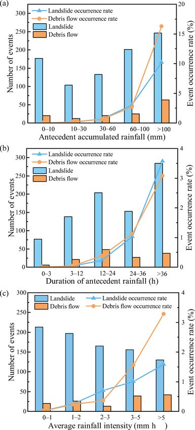
96                                     K. Zhang et al.: Characteristics and influencing factors of rainfall-induced landslide

slope angles for each grid cell. We then tabulated all of the
above gridded data with the following attributes: grid cell ID,
rainfall event ID, rainfall amount, rainfall duration, rainfall
intensity, rain intensity class, slope, land cover type, soil type
and hazard type. We defined a rainfall event as an event with
continuous rainfall or a combination of several discontinued
rains with the non-rain intermittent periods less than or equal
to 2 h.
   When we calculated the occurrence rate of one type of haz-
ard, we excluded all grid cells without any reported event of
this type of hazard and all rainless events from the analysis.
The occurrence rate of a kth type of hazard conditional on a
given explanatory variable or its class J (Rj,k ) is defined as

              n(J == j and K == k)
Rj,k =                                    ,                   (1)
         n[J == j and (K == k or K == 0)]

where K is the hazard type (0, 1 and 2 for rainfall event with-
out causing any geological hazard, rainfall-induced landslide
and rainfall-induced debris flow, respectively); J is the class
of Pa , D, I , θ, land cover type and soil type; n(J == j and
K == k) is the number of events of a given hazard k when
the corresponding J belongs to the j th class; and n[J == i
and (K == k or K == 0)] is the number of positive and
negative events of a given hazard k when the correspond-
ing J belongs to the j th class. In this study, we classified the
rainfall amount, rainfall duration, rainfall intensity and rain
type into five (0–10, 10–30, 30–60, 60–100 and > 100 mm),
five (0–3, 3–12, 12–24, 24–36 and > 36 h), five (0–1, 1–2, 2–
3, 3–5 and > 5 mm h−1 ) and four classes (light rain, moder-
ate rain, heavy rain and violent rain), respectively. Following      Figure 2. Locations of reported rainfall-triggered landslide and de-
the American Meteorology Society (Glickman and Walter,               bris flow events and the resultant casualties in Shaanxi Province
2000), light rain, moderate rain, heavy rain and violent rain        from 2009 to 2012; the inset shows the location of Shaanxi Province
are defined as rains when the precipitation rate is < 2.5, 2.5–      in China.
7.6, 7.6–50 and > 50 mm h−1 , respectively. We categorized
the slope, land cover type and soil type into five (0–2, 2–5,        (see Figs. 2 and 1a). In addition, the landslide events outnum-
5–10, 10–20 and > 20◦ ), three (cultivated land, forest and          ber the debris flow events (Fig. 2), indicating that landslide
grassland) and three classes (loamy sand, loam and clay), re-        occurs more frequently than debris flow in this region.
spectively. The other land cover types and soil types are not           There were a total of 1177 reported rainfall-triggered land-
used in the computation of the hazard occurrence rates be-           slide events in Shaanxi Province from 2009 to 2012 with 69,
cause we did not find any reported landslide or debris flow          619, 332 and 157 events in the 4 years (Fig. 3a), while a to-
event under these types.                                             tal of 209 rainfall-triggered debris flow events occurred in
                                                                     this province during the same period, with 6, 175, 13 and
4     Results                                                        15 events in the 4 years (Fig. 3a). More than half of the
                                                                     two types of events occurred in 2010. The corresponding
4.1    Spatiotemporal distributions of landslide and                 casualties are clearly proportional to the number of hazards
       debris flow events                                            (Fig. 3a). In particular, landslides and debris flows in 2010
                                                                     killed 72 and 73 people, respectively. During the 4-year pe-
The locations of the recorded landslide and debris flow              riod, the reported landslide and debris flow hazards caused
events and the resultant casualties from 2009 to 2012 are            the deaths of 131 and 78 people, respectively (Fig. 3a), in-
shown in Fig. 2. It is clear that all of these recorded land-        dicating that the two types of hazards are destructive in this
slide and debris flow events are located to the south of 36◦ N       region. Generally, debris flow is even more destructive than
(Fig. 2). In general, debris flow events are distributed further     landslide. Although the number of debris flow events ac-
south than landslides. Most of the landslide and debris flow         counts for only 15 % of the total events of the two haz-
events are near the rivers and/or in the areas with steep slopes     ards, the debris-flow-caused fatalities are 37.32 % of the total

Nat. Hazards Earth Syst. Sci., 19, 93–105, 2019                                 www.nat-hazards-earth-syst-sci.net/19/93/2019/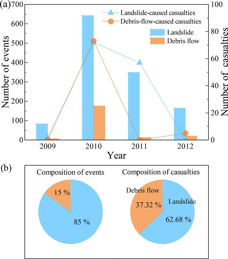
K. Zhang et al.: Characteristics and influencing factors of rainfall-induced landslide 97
The above results show that the landslide season is longer
than the debris flow season.
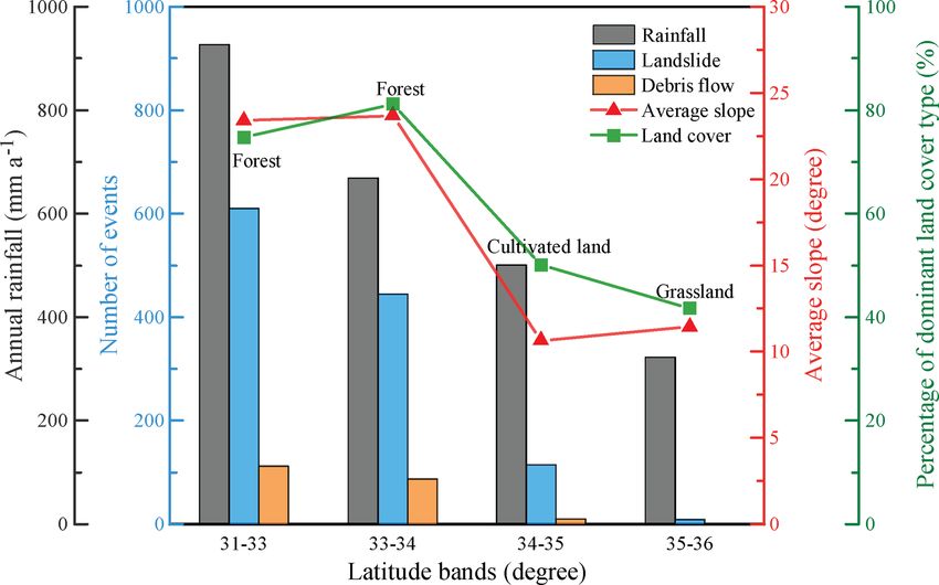
We further analyzed the latitudinal distribution of annual
rainfall, the number of landslides, the number of debris flows,
the zonal average slope and the percentages of dominant
land cover by dividing the region into four latitude bins (31–
33, 33–34, 34–35 and 35–36◦ N). As there are no reported
landslide and debris flow events in the areas north to 36◦ N,
we excluded these regions for analyzing the distributions of
these hazards and their relations to rainfall, terrain slope and
land cover in these areas. There are apparent latitudinal gra-
dients in annual rainfall and the numbers of reported land-
slide and debris flow events, which all decrease from the
south to the north (Fig. 5). The regional average terrain slope
generally decreases from the south to the north with values
of 23.4, 23.7, 10.7 and 11.4◦ in the four latitude bins (Fig. 5).
These results suggest that more rainfall and steeper slopes in
the south can explain the larger numbers of reported land-
slides and debris flows in the south than in the north. In addi-
tion, the southern part of this province (31–34◦ N) is mainly
covered by forests (≥ 78 %), while the regions between 34
and 35◦ N and between 35 and 36◦ N are dominated by cul-
tivated lands (50 %) and grasslands (47.1 %), respectively
Figure 3. (a) Interannual distributions of reported landslide and de- (Figs. 5 and 1a). Although the southern region has a denser
bris flow events and the associated casualties from 2009 to 2012 and and better preserved land cover than the middle and north-
(b) pie charts of the disaster types and their corresponding casual- ern parts, the southern region still experiences more landslide
ties. and debris flow hazards. This suggests that the meteorologi-
cal and geomorphological factors such as rainfall and terrain
slope play more important roles in controlling the landslide
and debris flow occurrence than land cover.
deaths caused by the two hazards (Fig. 3b). The above results
suggest that debris flow imposes a higher threat to people in
4.2 Impacts of rainfall amount, intensity and duration
this province per event than landslide.
on the landslide and debris flow occurrence
In terms of interannual distributions of the two hazards, to-
tal annual numbers of landslide and debris flow hazards show
a correlation with annual rainfall amount (Fig. 4a). However, To attribute the causes of the landslide and debris flow haz-
annual rainfall amount is not the only factor influencing the ards, we further analyzed the relationships between rain-
occurrences of the two hazards. For example, there is more fall characteristics (antecedent accumulated amount, dura-
annual rainfall in 2011 and 2012 than in 2010, but the total tion and intensity) and the occurrence rates of the two haz-
numbers of landslide and debris flow events in 2011 and 2012 ards. Both the number of landslide events and the number
are actually lower than these in 2010 (Fig. 4a). In terms of of debris flow events are not the least in the smallest an-
intra-annual distributions of the two hazards, landslide events tecedent rainfall amount. However, the number of landslide
are mainly distributed between July and September, which and debris flow events increases with an increasing amount
are the top 3 months in terms of both total rainfall amount of antecedent rainfall in the other four classes (Fig. 6a).
(Fig. 4b) and average rainfall intensity (Fig. 4c). Meanwhile, Meanwhile, the occurrence rate of debris flow exponentially
almost all debris flow events occurred in July, the month hav- increases with increasing antecedent rainfall amount (R =
ing the largest rainfall amount (Fig. 4b) and rainfall intensity 0.0022 exp (1.8127Pa ); R 2 = 0.988) (Fig. 6a). A similar re-
(Fig. 4c) with multi-year mean values of 117 mm month−1 lationship appears between the landslide occurrence rate
and 0.96 mm h−1 , respectively, during a year. Statistical anal- and antecedent rainfall amount (R = 0.0034 exp (1.6681Pa );
ysis shows that rainfall between July and September accounts R 2 = 0.977). However, the landslide occurrence rate is
for 63.6 % of annual rainfall, while the proportions of land- higher than the debris flow occurrence rate when antecedent
slide and debris flow events during the 3 months are 98.6 % accumulated rainfall is lower than 100 mm (Fig. 6a). Once
and 100 % of annual events, respectively. As can be seen, antecedent accumulated rainfall is above 100 mm, the debris
the landslide and debris flow hazards are seasonal hazards in flow occurrence rate becomes much larger than the landslide
Shaanxi Province and mainly occur during the rainy season. occurrence rate (Fig. 6a). This suggests that triggering a de-
www.nat-hazards-earth-syst-sci.net/19/93/2019/ Nat. Hazards Earth Syst. Sci., 19, 93–105, 2019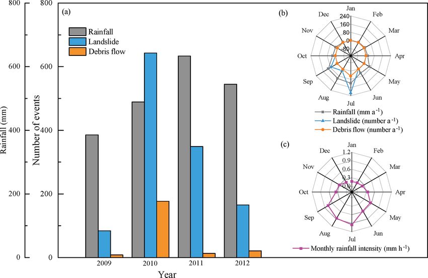
98                                       K. Zhang et al.: Characteristics and influencing factors of rainfall-induced landslide

Figure 4. (a) Yearly distributions and (b) monthly distributions of rainfall amount, the number of landslide events, and the number of debris
flow events from 2009 to 2012 and (c) the distribution of multi-year mean monthly rainfall intensity.

Figure 5. Distributions of annual rainfall amount, landslide events, and debris flow events along the latitude bands and spatial average slopes
and percentages of dominant land cover types in these latitude bands.

bris flow generally requires more rainfall than triggering a              (Fig. 6b). In addition, the occurrence rates of the two hazards
landslide.                                                                also show positive exponential relationships with the average
   The occurrence rates of the two hazards also show                      rainfall intensity (Fig. 6c). These results indicate that rainfall
positive exponential relationships with the rainfall dura-                amount, duration and intensity all play an important role in
tion (R = 0.0002 exp(1.7175D), R 2 = 0.997 for landslide;                 controlling the landslide and debris flow occurrence in this
R = 0.00009 exp(1.9526D), R 2 = 0.977 for debris flow)                    region. In addition, the three rainfall metrics usually corre-

Nat. Hazards Earth Syst. Sci., 19, 93–105, 2019                                      www.nat-hazards-earth-syst-sci.net/19/93/2019/
K. Zhang et al.: Characteristics and influencing factors of rainfall-induced landslide 99
Figure 7. Regional average occurrence rates of landslide and debris
flow events under different rainfall intensity classes.
In terms of the rainfall intensity, rainfall events can be clas-
sified into four classes, i.e., light rain, moderate rain, heavy
rain and violent rain according to the American Meteorology
Society. Therefore, we also calculated the regional average
occurrence rates of landslide and debris flow under the four
rain classes. Similar to the relationships between the occur-
rence rates and rainfall intensity (Fig. 6c), the regional aver-
age occurrence rates of the two hazards increase largely with
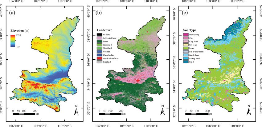
increasing rainfall class (Fig. 7). Furthermore, Fig. 8 shows
the spatial maps of landslide and debris occurrence rates
under different rain classes. As rain becomes severe, both
landslide and debris flow occur on more grid cells (Fig. 8a
and h). For example, light rains caused 163 landslide events
and 26 debris flow events during the 4-year period with av-
erage occurrence rates of 0.006 % and 0.005 %, respectively.
In contrast, violent rains have led to 273 landslide events and
60 debris flow events during the same period with average
occurrence rates of 2.70 % and 8.57 %, respectively. Mean-
while, the landslide occurrence rates on the grid cells that ex-
perience at least one landslide event during the 4-year period
increase with increased rainfall intensity as well (Fig. 8a–d).
As shown in Fig. 8e–h, the debris flow occurrence rates on
the grid cells that experience at least one debris flow event
during the 4-year period show a similar correlation with the
rain classes (or rainfall intensity classes).
4.3 Relationship of the landslide and debris flow
Figure 6. Relationship of occurrence rates of landslide and debris occurrence with slope, land cover type and soil type
flow events with the corresponding (a) accumulated amount of an-
tecedent continuous rainfall, (b) rainfall duration and (c) average Terrain, in particular terrain slope, is another important factor
rainfall intensity. determining slope stability. Therefore, we grouped the 90 m
grid cells with at least one reported landslide or debris flow
event during the study period into five slope bins, i.e., 0–2, 2–
late with each other to some extent. In other words, the rain- 5, 5–10, 10–20 and > 20◦ , and computed the respective land-
fall event that has the largest accumulated rainfall usually has slide and debris flow occurrence rates. It is obvious that there
a long duration and high average rainfall intensity. are strong positive correlations between the occurrence rates
of the two hazards and the slope angle (Fig. 9). Once again,
the landslide occurrence rate is clearly larger than the debris
www.nat-hazards-earth-syst-sci.net/19/93/2019/ Nat. Hazards Earth Syst. Sci., 19, 93–105, 2019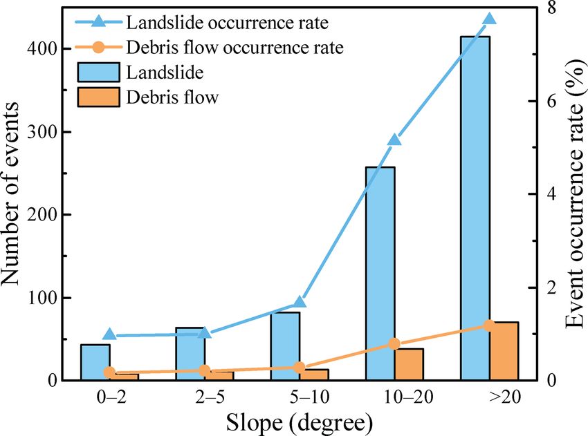
100                                       K. Zhang et al.: Characteristics and influencing factors of rainfall-induced landslide

Figure 8. Spatial distributions of the occurrence rates of (a–d) landslide and (e–h) debris flow under four rainfall intensity classes: light rain,
moderate rain, heavy rain and violent rain; only these grid cells with recorded landslide or debris flow events were analyzed and plotted in
this figure.

flow occurrence rate under all five slope classes (Fig. 9). Rel-
ative to debris flow, landslide occurrence is more sensitive to
terrain slope (Fig. 9). With increasing terrain slope, the land-
slide occurrence rate accelerates much faster than the debris
flow occurrence rate.
    We further analyzed the relationships of the hazard occur-
rence rates with land cover type and soil type. For debris flow,
the occurrence rate is higher on the cultivated lands, followed
by forests and grasslands (Fig. 10a). As shown in Fig. 1b,
grasslands are mainly located in the north where there is less
rainfall and much flatter terrain than in the south. Therefore,
it is not a surprise to observe a lower debris flow occurrence
rate on grasslands than on cultivated lands and forests. For
landslide, the occurrence rate is also the highest on culti-                Figure 9. Occurrence rates of landslide and debris flow under dif-
vated lands, but the occurrence rates on forests and grass-                 ferent degrees of terrain slopes.
lands are very similar (Fig. 10a). Higher occurrence rates for
both landslide and debris flow on cultivated lands than on

Nat. Hazards Earth Syst. Sci., 19, 93–105, 2019                                         www.nat-hazards-earth-syst-sci.net/19/93/2019/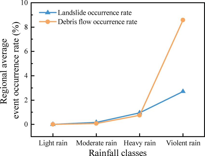
K. Zhang et al.: Characteristics and influencing factors of rainfall-induced landslide                                               101

Figure 10. Occurrence rates of landslide and debris flow under different (a) land cover types and (b) soil types.

forests and grassland suggest that the destruction and conver-           slide and debris flow. Relatively speaking, rainfall amount
sion of natural dense land cover can weaken slope stability,             and rainfall duration have higher impacts on the occurrence
making these areas more susceptible to landslides.                       of landslide and debris flow than average rainfall intensity
   In this region, our analysis based on the available data does         in this region. This is because a rainstorm with higher aver-
not show that soil type imposes apparent consistent effects              age rainfall intensity does not necessary last for a long du-
on the occurrence rates of landslide and debris flow. For ex-            ration and leads to a larger accumulated rainfall amount. In
ample, landslide has the highest occurrence rate in the clay             addition, one has to note that the three rainfall characteristics
soil among the tree-dominant soil types in this region, while            do not necessarily correlate with each other. Previous studies
the landslide occurrence rates in the loam soil and the loamy            have pointed out that different types of landslides and de-
sand soil are comparable (Fig. 10b). In contrast, debris flow            bris flows have different critical rainfall conditions for fail-
has the highest occurrence rate in the loamy sand soil, while            ure considering the different geologic and geomorphologic
the debris flow occurrence rates are similar in the loam and             conditions (Zezere et al., 2015; Guzzetti et al., 2008). For
clay soils (Fig. 10b).                                                   example, rapid debris flows are typically triggered by very
                                                                         intense showers concentrated in a few hours, while shallow
                                                                         translational soil slips are usually triggered by intense precip-
5   Discussions                                                          itation falling within a few days (Zezere et al., 2015). In con-
                                                                         trast, deep-seated landslides of rotational, translational and
Based on the survey of rainfall-induced landslide and debris             complex types are related to long periods (weeks to months)
flow hazards from 2009 to 2012 in Shaanxi Province, China,               of nearly constant rainfall (Zezere et al., 2015; Chen et al.,
our results show that both landslide and debris flow occur fre-          2013). In general, rainfall with a long duration and large
quently in this region and are mainly distributed in the south-          amount is more likely to trigger landslide and debris flow
ern part of this province, which has more rainfall and steeper           (Saito et al., 2014).
terrain slopes than the other areas of this province. Land-                 Terrain slope is another important factor influencing the
slide happens more frequently than debris flow. Although                 slope stability since gravity makes these slopes with higher
the number of the reported debris flow events is only one-               slope angles more vulnerable (Nourani et al., 2014; Dehnavi
sixth of the number of the recorded landslide events in this             et al., 2015). In addition, terrains with steep slopes make
region, the debris-flow-caused casualties are equal to 60 % of           plants harder to establish and grow. Furthermore, it is harder
the landslide-caused casualties. Clearly, debris flow is more            for vegetation roots to reach the sliding surface if the slope
destructive than landslide in this region in terms of the ca-            is steep (usually exceed 1.5 m) (Ocakoglu et al., 2002; Cam-
sualty per event. Like many areas in the world, debris flow              meraat et al., 2005). In this case vegetation biomass may in-
usually occurs in areas near stream networks, which usually              crease the weight of landslide body and promote the occur-
have a higher population. Moreover, debris flow usually car-             rence of landslides (Nilaweera and Nutalaya, 1999; Collison
ries more materials and travels a longer distance than land-             and Anderson, 1996). The terrain and vegetation can interact
slide, making it more harmful to people and property (Ietto              with each other to create complex hydrological and mechan-
et al., 2016). In fact, most debris flow events are initialized          ical effects on the slope stability. Benefits from vegetation
from landslide and cause more damage to the environment                  are conditional on the geological and geomorphological con-
and society (Peng et al., 2015; Zhou et al., 2013).                      ditions (Nilaweera and Nutalaya, 1999; Collison and Ander-
   Our results show that rainfall characteristics including              son, 1996).
rainfall amount, rainfall intensity and rainfall duration all
play important roles in controlling the occurrence of land-

www.nat-hazards-earth-syst-sci.net/19/93/2019/                                       Nat. Hazards Earth Syst. Sci., 19, 93–105, 2019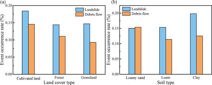
102                                  K. Zhang et al.: Characteristics and influencing factors of rainfall-induced landslide

   Land cover type is another factor that impacts the slope       cumulated rainfall amount and intensity are at a high level.
stability. As shown in our results (Fig. 10), cultivated lands    Responses of the landslide and debris flow occurrence rates
have higher landslide and debris flow occurrence rates than       to rainfall duration do not differ much between each other.
forests in the same climatic zone. Similar findings were also     The occurrence of both landslide and debris flow also largely
reported in previous research, showing that conversion of         depends on the terrain slope, but landslide has a higher sen-
natural vegetated lands, in particular forests, to cultivated     sitivity to terrain slope than debris flow does. Our results
lands or the early-stage abandonment of cultivated lands          also show that land cover also influences the occurrence of
can largely weaken slope stability by increasing surface wa-      the two hazards to some extent in this region. In particular,
ter runoff, intensifying erosion processes and increasing soil    both landslide and debris flow has lower occurrence rates
instability (Begueria, 2006; Lopez-Saez et al., 2016; Per-        on natural vegetated land than on cultivated lands. How-
sichillo et al., 2017). In addition, the slopes with woody veg-   ever, the study does not find an apparent relationship be-
etation are more stable than those with herbaceous vegeta-        tween the occurrence rates of the two hazards and soil type.
tion because woody vegetation has deeper roots than herba-        In summary, we compiled an important data inventory of
ceous vegetation and can draw down soil moisture, making          the rainfall-triggered landslide and debris flow hazards in
the slopes more stable (Kim et al., 2017; Begueria, 2006). In     Shaanxi Province, China, based on a 4-year survey and re-
addition, some studies also show that the stand age, structure    vealed the spatiotemporal distributions and characteristics of
and composition of vegetation can influence the slope stabil-     these events and the impacts of rainfall characteristics, to-
ity (Turner et al., 2010).                                        pography and soil type on the occurrence of landslide and
   In this region, soil type does not appear to impose appar-     debris. This study not only provides an important inventory
ent consistent effects on the occurrence rates of landslide and   data for understanding the formation mechanisms and char-
debris flow based on the available data. These results sug-       acteristics of the landslide and debris flow hazards but also
gest that soil type is not the dominant factor influencing the    adds valuable information for modeling and predicting the
slope stability in this region. As shown in other studies, soil   rainfall-triggered landslide and debris flow hazards to im-
types and their physical properties such as cohesion, satu-       prove preparedness for and enhance resilience to these haz-
rated hydraulic conductivity, porosity and friction angle have    ards in this region and the other similar areas.
impacts on the slope failure and stability (Antinoro et al.,
2017; van Asch and Malet, 2009; Zhang et al., 2016; Pasculli
et al., 2017; Milne et al., 2012).                                Data availability. The DEM data used in this study were pro-
                                                                  vided by the geospatial data cloud (http://www.gscloud.cn, DEM
                                                                  data, 2017). The land cover data were derived from GlobeLand30-
                                                                  2010, which is a product of global land cover at a spatial res-
6   Conclusions
                                                                  olution of 30 m derived from remote-sensing images in 2010
                                                                  (Chen et al., 2015a, http://www.globeland30.cn, last access: 2 Jan-
In this paper, we analyzed the spatiotemporal distributions,
                                                                  uary 2017). The soil data are from the Harmonized World
occurrence rates and resultant casualties of rainfall-triggered   Soil Database (HWSD) v1.2 (https://daac.ornl.gov/SOILS/guides/
landslide and debris flow based on a survey from 2009             HWSD.html, Soil data, 2017). Rainfall data were provided by the
to 2012 in Shaanxi Province, China. Our results show that         National Meteorological Information Center of China Meteorologi-
landslide has a higher occurrence rate and more extensive         cal Administration (http://data.cma.cn, last access: 9 January 2019).
distribution than debris flow in Shaanxi Province, while both     The other data can be provided by the authors upon request.
of the two hazards are concentrated in the south of this re-
gion with ample rainfall and relatively steep terrains. Debris
flow is more destructive than landslide in terms of the casu-     Author contributions. KZ designed the study; SW and KZ con-
alties per event. Both landslide and debris flow show a clear     ducted this study; KZ and SW wrote this paper; HB and XZ pro-
seasonality corresponding to the rainy season in this region.     vided the data and reviewed this paper.
Debris flow mainly occurs in July, whereas landslide usually
takes place between July and September.
   The characteristics of rainfall events including accumu-       Competing interests. The authors declare that they have no conflict
                                                                  of interest.
lated rainfall amount, duration, and intensity and terrain
slope show the strongest impacts on the slope stability and
the occurrence rates of landslide and debris flow. The land-
                                                                  Acknowledgements. This study was supported by the National Key
slide and debris flow occurrences have exponential relation-
                                                                  Research and Development Program of China (2018YFC1508101
ships with all of the above four factors (P < 0.1). When ac-      and 2016YFC0402701), National Natural Science Foundation
cumulated rainfall amount and intensity are on the low and        of China (51879067, 41775111, 41875131), Natural Science
intermediate levels, landslide has a higher occurrence rate       Foundation of Jiangsu Province (BK20180022), Six Talent Peaks
than debris flow. Conversely, the debris flow occurrence rate     Project in Jiangsu Province (NY-004), Key Research & Devel-
is much higher than the landslide occurrence rate when ac-        opment Program of Ningxia Hui Automonous Region, China

Nat. Hazards Earth Syst. Sci., 19, 93–105, 2019                              www.nat-hazards-earth-syst-sci.net/19/93/2019/
K. Zhang et al.: Characteristics and influencing factors of rainfall-induced landslide 103
(2018BEG02010), Fundamental Research Funds for the Central tor machine models for the Qianyang County, China, Environ.
Universities of China (2018B42914), Open Foundation of State Earth Sci., 75, 474, https://doi.org/10.1007/s12665-015-5093-0,
Key Laboratory of Hydrology-Water Resources and Hydraulic 2016.
Engineering (2017490311), and Priority Academic Program Chen, W., Pourghasemi, H. R., and Zhao, Z.: A GIS-
Development of Jiangsu Higher Education Institutions. based comparative study of Dempster-Shafer, logistic re-
gression and artificial neural network models for land-
Edited by: Mario Parise slide susceptibility mapping, Geocarto Int., 32, 367–385,
Reviewed by: two anonymous referees https://doi.org/10.1080/10106049.2016.1140824, 2017.
Chen, Y. C., Chang, K. T., Chiu, Y. J., Lau, S. M., and Lee, H. Y.:
Quantifying rainfall controls on catchment-scale landslide ero-
sion in Taiwan, Earth Surf. Proc. Land., 38, 372–382, 2013.
References Collison, A. J. C. and Anderson, M. G.: Using a combined slope hy-
drology stability model to identify suitable conditions for land-
Althuwaynee, O. F., Pradhan, B., Park, H. J., and Lee, J. slide prevention by vegetation in the humid tropics, Earth Surf.
H.: A novel ensemble bivariate statistical evidential be- Proc. Land., 21, 737–747, https://doi.org/10.1002/(Sici)1096-
lief function with knowledge-based analytical hierarchy 9837(199608)21:83.0.Co;2-F, 1996.
process and multivariate statistical logistic regression Dehnavi, A., Aghdam, I. N., Pradhan, B., and Varzandeh,
for landslide susceptibility mapping, Catena, 114, 21–36, M. H. M.: A new hybrid model using step-wise weight
https://doi.org/10.1016/j.catena.2013.10.011, 2014. assessment ratio analysis (SWAM) technique and adaptive
Alvioli, M. and Baum, R. L.: Parallelization of the TRIGRS model neuro-fuzzy inference system (ANFIS) for regional land-
for rainfall-induced landslides using the message passing inter- slide hazard assessment in Iran, Catena, 135, 122–148,
face, Environ. Model. Softw., 81, 122–135, 2016. https://doi.org/10.1016/j.catena.2015.07.020, 2015.
Antinoro, C., Arnone, E., and Noto, L. V.: The use of DEM data: Geospatial Data Cloud, available at: http://www.
soil water retention curve models in analyzing slope sta- gscloud.cn, last access: 4 January 2017.
bility in differently structured soils, Catena, 150, 133-145, Gariano, S. L., Brunetti, M. T., Iovine, G., Melillo, M., Peruccacci,
10.1016/j.catena.2016.11.019, 2017. S., Terranova, O., Vennari, C., and Guzzetti, F.: Calibration and
Baum, R. L., Godt, J. W., and Savage, W. Z.: Estimating the tim- validation of rainfall thresholds for shallow landslide forecasting
ing and location of shallow rainfall-induced landslides using a in Sicily, southern Italy, Geomorphology, 228, 653–665, 2015.
model for transient, unsaturated infiltration, J. Geophys. Res., Glickman, T. S. and Walter, Z.: Glossary of Meteorology, 2nd Edn.,
115, F03013, https://doi.org/10.1029/2009jf001321, 2010. Boston, MA, 2000.
Begueria, S.: Changes in land cover and shallow landslide activity: Guzzetti, F., Peruccacci, S., Rossi, M., and Stark, C. P.: Rain-
A case study in the Spanish Pyrenees, Geomorphology, 74, 196– fall thresholds for the initiation of landslides in central
206, https://doi.org/10.1016/j.geomorph.2005.07.018, 2006. and southern Europe, Meteorol. Atmos. Phys., 98, 239–267,
Blothe, J. H., Korup, O., and Schwanghart, W.: Large landslides https://doi.org/10.1007/s00703-007-0262-7, 2007.
lie low: Excess topography in the Himalaya-Karakoram ranges, Guzzetti, F., Peruccacci, S., Rossi, M., and Stark, C. P.: The rainfall
Geology, 43, 523–526, https://doi.org/10.1130/g36527.1, 2015. intensity–duration control of shallow landslides and debris flows:
Bogaard, T. and Greco, R.: Invited perspectives: Hydrological an update, Landslides, 5, 3–17, https://doi.org/10.1007/s10346-
perspectives on precipitation intensity-duration thresholds 007-0112-1, 2008.
for landslide initiation: proposing hydro-meteorological Han, Z., Li, Y. G., Huang, J. L., Chen, G. Q., Xu, L. R., Tang,
thresholds, Nat. Hazards Earth Syst. Sci., 18, 31–39, C., Zhang, H., and Shang, Y. H.: Numerical simulation for run-
https://doi.org/10.5194/nhess-18-31-2018, 2018. out extent of debris flows using an improved cellular automaton
Borga, M., Stoffel, M., Marchi, L., Marra, F., and Jakob, M.: Hy- model, B. Eng. Geol. Environ., 76, 961–974, 2017.
drogeomorphic response to extreme rainfall in headwater sys- He, X. G., Hong, Y., Vergara, H., Zhang, K., Kirstetter, P. E., Gour-
tems: Flash floods and debris flows, J. Hydrol., 518, 194–205, ley, J. J., Zhang, Y., Qiao, G., and Liu, C.: Development of a cou-
https://doi.org/10.1016/j.jhydrol.2014.05.022, 2014. pled hydrological-geotechnical framework for rainfall-induced
Cammeraat, E., van Beek, R., and Kooijman, A.: Vegetation succes- landslides prediction, J. Hydrol., 543, 395–405, 2016.
sion and its consequences for slope stability in SE Spain, Plant Hong, H. Y., Pradhan, B., Xu, C., and Tien Bui, D.: Spatial
Soil, 278, 135–147, https://doi.org/10.1007/s11104-005-5893-1, prediction of landslide hazard at the Yihuang area (China)
2005. using two-class kernel logistic regression, alternating deci-
Chen, J., Chen, J., Liao, A. P., Cao, X., Chen, L. J., Chen, X. H., sion tree and support vector machines, Catena, 133, 266–281,
He, C. Y., Han, G., Peng, S., Lu, M., Zhang, W. W., Tong, X. H., https://doi.org/10.1016/j.catena.2015.05.019, 2015.
and Mills, J.: Global land cover mapping at 30 m resolution: A Hong, H. Y., Chen, W., Xu, C., Youssef, A. M., Pradhan, B.,
POK-based operational approach, ISPRS J. Photogram. Remote and Bui, D. T.: Rainfall-induced landslide susceptibility assess-
Sens., 103, 7–27, 2015a. ment at the Chongren area (China) using frequency ratio, cer-
Chen, J. J., Zeng, Z. G., Jiang, P., and Tang, H. M.: tainty factor, and index of entropy, Geocarto Int., 32, 139–154,
Deformation prediction of landslide based on func- https://doi.org/10.1080/10106049.2015.1130086, 2017a.
tional network, Neurocomputing, 149, 151–157, Hong, H. Y., Liu, J. Z., Zhu, A. X., Shahabi, H., Pham, B. T.,
https://doi.org/10.1016/j.neucom.2013.10.044, 2015b. Chen, W., Pradhan, B., and Bui, D. T.: A novel hybrid in-
Chen, W., Chai, H. C., Zhao, Z., Wang, Q. Q., and Hong, H. Y.: tegration model using support vector machines and random
Landslide susceptibility mapping based on GIS and support vec-
www.nat-hazards-earth-syst-sci.net/19/93/2019/ Nat. Hazards Earth Syst. Sci., 19, 93–105, 2019104 K. Zhang et al.: Characteristics and influencing factors of rainfall-induced landslide
subspace for weather-triggered landslide susceptibility assess- Nicolussi, K., Spotl, C., Thurner, A., and Reimer, P. J.:
ment in the Wuning area (China), Environ. Earth Sci., 76, 652, Precise radiocarbon dating of the giant Weis landslide
https://doi.org/10.1007/s12665-017-6981-2, 2017b. (Eastern Alps, Austria), Geomorphology, 243, 87–91,
Hong, Y., Adler, R., and Huffman, G.: Use of satellite remote sens- https://doi.org/10.1016/j.geomorph.2016.05.001, 2015.
ing data in the mapping of global landslide susceptibility, Nat Nilaweera, N. S. and Nutalaya, P.: Role of tree roots in slope stabil-
Hazards, 43, 245-256, 2007. isation, B. Eng. Geol. Environ., 57, 337–342, 1999.
Hong, Y., He, X. G., Cerato, A., Zhang, K., Hong, Z., and Liao, Nourani, V., Pradhan, B., Ghaffari, H., and Sharifi, S. S.: Land-
Z. H.: Predictability of a Physically Based Model for Rainfall- slide susceptibility mapping at Zonouz Plain, Iran using genetic
induced Shallow Landslides: Model Development and Case programming and comparison with frequency ratio, logistic re-
Studies, Modern Technol. Landslide Monitor. Predict., 2, 165– gression, and artificial neural network models, Nat. Hazards, 71,
178, https://doi.org/10.1007/978-3-662-45931-7_9, 2015. 523–547, https://doi.org/10.1007/s11069-013-0932-3, 2014.
Huang, X. H., Li, Z. Y., Yu, D., Xu, Q., Fan, J. Y., Hao, Z., Ocakoglu, F., Gokceoglu, C., and Ercanoglu, M.: Dynamics of
and Niu, Y. P.: Evolution of a giant debris flow in the tran- a complex mass movement triggered by heavy rainfall: a
sitional mountainous region between the Tibetan Plateau and case study from NW Turkey, Geomorphology, 42, 329–341,
the Qinling Mountain range, Western China: Constraints from https://doi.org/10.1016/S0169-555x(01)00094-0, 2002.
broadband seismic records, J. Asian Earth Sci., 148, 181–191, Pasculli, A., Sciarra, N., Esposito, L., and Esposito, A.
https://doi.org/10.1016/j.jseaes.2017.08.031, 2017. W.: Effects of wetting and drying cycles on mechani-
Ietto, F., Perri, F., and Cella, F.: Geotechnical and land- cal properties of pyroclastic soils, Catena, 156, 113–123,
slide aspects in weathered granitoid rock masses (Serre https://doi.org/10.1016/j.catena.2017.04.004, 2017.
Massif, southern Calabria, Italy), Catena, 145, 301–315, Peng, J. B., Fan, Z. J., Wu, D., Zhuang, J. Q., Dai, F. C., Chen,
https://doi.org/10.1016/j.catena.2016.06.027, 2016. W. W., and Zhao, C.: Heavy rainfall triggered loess-mudstone
Jaboyedoff, M., Oppikofer, T., Abellan, A., Derron, M. H., landslide and subsequent debris flow in Tianshui, China, Eng.
Loye, A., Metzger, R., and Pedrazzini, A.: Use of LIDAR Geol., 186, 79–90, 2015.
in landslide investigations: a review, Nat. Hazards, 61, 5–28, Persichillo, M. G., Bordoni, M., and Meisina, C.: The
https://doi.org/10.1007/s11069-010-9634-2, 2012. role of land use changes in the distribution of shal-
Jiang, R. G., Xie, J. C., He, H. L., Luo, J. G., and Zhu, J. W.: Use of low landslides, Sci. Total Environ., 574, 924–937,
four drought indices for evaluating drought characteristics under https://doi.org/10.1016/j.scitotenv.2016.09.125, 2017.
climate change in Shaanxi, China: 1951–2012, Nat. Hazards, 75, Peruccacci, S., Brunetti, M. T., Luciani, S., Vennari, C.,
2885–2903, https://doi.org/10.1007/s11069-014-1468-x, 2015. and Guzzetti, F.: Lithological and seasonal control on
Kim, J. H., Fourcaud, T., Jourdan, C., Maeght, J. L., Mao, Z., rainfall thresholds for the possible initiation of land-
Metayer, J., Meylan, L., Pierret, A., Rapidel, B., Roupsard, O., de slides in central Italy, Geomorphology, 139, 79–90,
Rouw, A., Sanchez, M. V., Wang, Y., and Stokes, A.: Vegetation https://doi.org/10.1016/j.geomorph.2011.10.005, 2012.
as a driver of temporal variations in slope stability: The impact Petley, D. N.: On the impact of climate change and popula-
of hydrological processes, Geophys. Res. Lett., 44, 4897–4907, tion growth on the occurrence of fatal landslides in South,
https://doi.org/10.1002/2017gl073174, 2017. East and SEAsia, Q. J. Eng. Geol. Hydrogeol., 43, 487–496,
Liao, Z. H., Hong, Y., Kirschbaum, D., and Liu, C.: Assessment https://doi.org/10.1144/1470-9236/09-001, 2010.
of shallow landslides from Hurricane Mitch in central America Pradhan, B. and Youssef, A. M.: Manifestation of remote
using a physically based model, Environ. Earth Sci., 66, 1697– sensing data and GIS on landslide hazard analysis using
1705, https://doi.org/10.1007/s12665-011-0997-9, 2012. spatial-based statistical models, Arab. J. Geosci., 3, 319–326,
Lopez-Saez, J., Corona, C., Eckert, N., Stoffel, M., Bour- https://doi.org/10.1007/s12517-009-0089-2, 2010.
rier, F., and Berger, F.: Impacts of land-use and land- Qin, S. Q., Jiao, J. J., and Wang, S. J.: The predictable time scale of
cover changes on rockfall propagation: Insights from the landslides, B. Eng. Geol. Environ., 59, 307–312, 2001.
Grenoble conurbation, Sci. Total Environ., 547, 345–355, Saito, H., Korup, O., Uchida, T., Hayashi, S., and Oguchi, T.: Rain-
https://doi.org/10.1016/j.scitotenv.2015.12.148, 2016. fall conditions, typhoon frequency, and contemporary landslide
Milne, F. D., BrownA, M. J., Knappett, J. A., and Davies, M. C. R.: erosion in Japan, Geology, 42, 999–1002, 2014.
Centrifuge modelling of hillslope debris flow initiation, Catena, Soil data: Regridded Harmonized World Soil Database v1.2, avail-
92, 162–171, 2012. able at: https://daac.ornl.gov/SOILS/guides/HWSD.html, last ac-
Montgomery, D. R. and Dietrich, W. E.: A physically based model cess: 22 Feburary 2017.
for the topographic control on shallow landsliding, Water Resour. Sorbino, G., Sica, C., and Cascini, L.: Susceptibility analysis of
Res., 30, 1153–1171, 1994. shallow landslides source areas using physically based models,
Montrasio, L. and Valentino, R.: A model for triggering mecha- Nat. Hazards, 53, 313–332, https://doi.org/10.1007/s11069-009-
nisms of shallow landslides, Nat. Hazards Earth Syst. Sci., 8, 9431-y, 2010.
1149–1159, https://doi.org/10.5194/nhess-8-1149-2008, 2008. Sun, P., Peng, J. B., Chen, L. W., Lu, Q. Z., and Igwe, O.: An ex-
Naef, D., Rickenmann, D., Rutschmann, P., and McArdell, B. W.: perimental study of the mechanical characteristics of fractured
Comparison of flow resistance relations for debris flows using loess in western China, B. Eng. Geol. Environ., 75, 1639–1647,
a one-dimensional finite element simulation model, Nat. Haz- https://doi.org/10.1007/s10064-015-0793-y, 2016.
ards Earth Syst. Sci., 6, 155–165, https://doi.org/10.5194/nhess- Turner, T. R., Duke, S. D., Fransen, B. R., Reiter, M. L., Kroll, A.
6-155-2006, 2006. J., Ward, J. W., Bach, J. L., Justice, T. E., and Bilby, R. E.: Land-
slide densities associated with rainfall, stand age, and topography
Nat. Hazards Earth Syst. Sci., 19, 93–105, 2019 www.nat-hazards-earth-syst-sci.net/19/93/2019/K. Zhang et al.: Characteristics and influencing factors of rainfall-induced landslide 105 on forested landscapes, southwestern Washington, USA, Forest Zhang, P., Ma, J. Z., Shu, H. P., Han, T., and Zhang, Y. L.: Simulat- Ecol. Manage., 259, 2233–2247, 2010. ing debris flow deposition using a two-dimensional finite model van Asch, T. W. J. and Malet, J. P.: Flow-type failures in and Soil Conservation Service-curve number approach for Han- fine-grained soils: an important aspect in landslide haz- lin gully of southern Gansu (China), Environ. Earth Sci., 73, ard analysis, Nat. Hazards Earth Syst. Sci., 9, 1703–1711, 6417–6426, 2015. https://doi.org/10.5194/nhess-9-1703-2009, 2009. Zhang, Y. C., Zhang, F., Zhang, J. Q., Guo, E. L., Liu, X. Wooten, R. M., Gillon, K. A., Witt, A. C., Latham, R. S., Douglas, P., and Tong, Z. J.: Research on the Geological Disas- T. J., Bauer, J. B., Fuemmeler, S. J., and Lee, L. G.: Geologic, ge- ter Forecast and Early Warning Model Based on the Opti- omorphic, and meteorological aspects of debris flows triggered mal Combination Weighing Law and Extension Method: a by Hurricanes Frances and Ivan during September 2004 in the Case Study in China, Pol. J. Environ. Stud., 26, 2385–2395, Southern Appalachian Mountains of Macon County, North Car- https://doi.org/10.15244/pjoes/69100, 2017. olina (southeastern USA), Landslides, 5, 31–44, 2008. Zhou, J. W., Cui, P., Yang, X. G., Su, Z. M., and Guo, X. J.: De- Wu, H. and Qian, H.: Innovative trend analysis of an- bris flows introduced in landslide deposits under rainfall condi- nual and seasonal rainfall and extreme values in Shaanxi, tions: The case of Wenjiagou gully, J. Mt. Sci.-Engl., 10, 249– China, since the 1950s, Int. J. Climatol., 37, 2582–2592, 260, 2013. https://doi.org/10.1002/joc.4866, 2017. Zhu, X., Xu, Q., Tang, M. G., Nie, W., Ma, S. Q., and Xu, Z. Zezere, J. L., Vaz, T., Pereira, S., Oliveira, S. C., Marques, R., and P.: Comparison of two optimized machine learning models for Garcia, R. A. C.: Rainfall thresholds for landslide activity in Por- predicting displacement of rainfall-induced landslide: A case tugal: a state of the art, Environ. Earth Sci., 73, 2917–2936, 2015. study in Sichuan Province, China, Eng. Geol., 218, 213–222, Zhang, K., Xue, X., Hong, Y., Gourley, J. J., Lu, N., Wan, Z., Hong, https://doi.org/10.1016/j.enggeo.2017.01.022, 2017. Z., and Wooten, R.: iCRESTRIGRS: a coupled modeling system Zhuang, J. Q. and Peng, J. B.: A coupled slope cutting-a prolonged for cascading flood-landslide disaster forecasting, Hydrol. Earth rainfall-induced loess landslide: a 17 October 2011 case study, Syst. Sci., 20, 5035–5048, https://doi.org/10.5194/hess-20-5035- B. Eng. Geol. Environ., 73, 997–1011, 2014. 2016, 2016. www.nat-hazards-earth-syst-sci.net/19/93/2019/ Nat. Hazards Earth Syst. Sci., 19, 93–105, 2019
You can also read