Ecological Connectivity in the Danube River Basin - Future Perspectives and Guiding Principles
←
→
Page content transcription
If your browser does not render page correctly, please read the page content below
Ecological Connectivity
       in the Danube River Basin
Future Perspectives and Guiding Principles
Ecological Connectivity
       in the Danube River Basin
Future Perspectives and Guiding Principles

          Project co-funded by the European Union (ERDF, IPA funds)
Imprint
Editing: 			              Fuchs Anneliese, Jungmeier Michael (E.C.O.)
Text:			                  Fuchs Anneliese, Frank Georg, Blutaumüller Stephanie, Huber Michael, Jungmeier Michael
Contributions:            Hein Thomas, Kuba Martin, Vasić Ivana, Wagner Magdalena
Layout:                   Fuchs Anneliese, Kovarovics Anna
Maps:			                  Fuchs Anneliese, Grigull Maxim, Berger Vanessa, Glatz-Jorde Susanne
Cover Picture:            DANUBEPARKS/Duna-Ipoly National Park Directorat
Chapter Pictures:         Donau-Auen National Park/Kudich, Donau-Auen National Park/Kern, DANUBEPARKS/Donau-
                          Auen National Park, Danube Delta Biosphere Reserve Authority/Petrescu, Danube Delta
                          Biosphere Reserve Authority/Bandacu
Proofreading:             Callaghan Ian
Print:                    Kontraszt Plusz Kft.

The complete or partial storage, reproduction or transmission of the work, whether electronically, mechanically, by photocopy
or recording, is prohibited without the prior permission of the copyright holder.

The project is co-funded by the European Union (ERDF, IPA funds).

Produced using environmentally friendly technologies and materials.

Copyright reserved.
© DANUBEPARKS 2019

Citation:
DANUBEPARKS (2019) Ecological Connectivity in the Danube River Basin. Future Perspectives and Guiding Principles. Orth
an der Donau, 64 pp.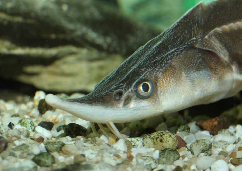
Dear Readers,                                                     and semi-natural areas including healthy ecosystems with a
                                                                  rich diversity of species that provide multiple ecosystem ser-
The Danube River is a symbol and a lifeline for several coun-     vices and benefits.
tries which needs to be safeguarded and restored. In the
beginning of this century 75% of the Lower Danube’s flood-        The European Commission is working towards a European
plains were cut off by dykes as a result of land conversion for   Green Deal which aims, inter alia, to make the protection
farming and development causing increased pollution and           and restoration of ecosystems a Leitmotif for decision ma-
flood risks, threats which are expected to be exacerbated by      kers, including cohesion policy. DANUBEparksCONNEC-
climate change.  The EU environment and biodiversity policy       TED, which is supported by the European Territorial Coope-
including the EU Birds, Habitats and Water Framework Di-          ration Interreg programme, is one of the examples included
rectives aim to support Member States to reverse that trend.      in the ‘Guidance on a strategic framework for further sup-
The “Lower Danube Green Corridor”, a 1,000 km long cor-           porting the deployment of EU-level green and blue infra-
ridor with many Natura 2000 sites has made significant im-        structure (SWD(2019) 193 final) published by the European
provements to water quality, increased biodiversity, lowered      Commission in 2019. The guidance lays out the definition
risks from flooding and improved local livelihoods.               and criteria for EU-level green and blue infrastructure pro-
                                                                  jects.   It shows what can be achieved, if countries decide
Green and Blue Infrastructure is an efficient tool to conser-     to join forces behind a common objective. I hope that this
ve and enhance the multiple benefits that nature provides.        important and ambitious initiative will be continued, scaled
The science is clear: in order to stem interlinked and inter-     up and replicated also in other regions.
dependent challenges such as biodiversity loss and clima-
te change we need to work with nature rather than against
                                                                  Stefan Leiner
it.  The present poly-crisis cannot be solved by dealing with
each issue in isolation or in a consecutive manner. It needs
                                                                  Head of Biodiversity Unit
partnerships, solidarity and swift implementation of integra-
                                                                  European Commission
ted approaches such as nature-based solutions to climate
                                                                  Directorate
change adaptation and mitigation and disaster risk reduc-
                                                                  General Environment
tion. We need strategically planned networks with natural
Dear Readers,

Understanding the conservation values of ecological corri-       than the blackberry, the social values of the “green infra-
dors is one of the basic foundations to understand how life      structure” are as important as their biodiversity values in or-
on the planet can survive in the face of human overpopulati-     der to reconnect people with nature.
on trends and competing demands for land use.
                                                                 Discussions on the importance of connectivity have gained
Conservation importance of such corridors is sometimes           adequate attention in the global biodiversity conservation
difficult to recognise at a first glance, especially when com-   agenda. New global targets for the post 2020 period clearly
paring corridors with emblematic patches of habitats in pro-     indicate the importance of connected protected and con-
tected and conserved areas, and if looking at the corridors      served areas. Although the publication “Ecological Connec-
only over a short period. It might come as a surprise, but       tivity in the Danube River Basin” explores the connectivity
the number of song-bird species determined in one scenic         between the various habitats in the Danube River Basin, its
wetland area, known for its birds, can be very similar to the    findings and guidance go beyond regional importance.
number of species detected in the longer observation period
in the floodplains up- and downstream of the river, passing
that wetland.

It is important to understand that organisms need to move        Andrej Sovinc
from one habitat to another and that their survival is not de-
pendent only on safeguarding their reproduction areas. The       IUCN World Commision on
term „organisms“ also includes humans; in times when the         Protected Areas
amount of time people in the western world spend indoors         Regional Vice-Chair
exceeds 90% and our children play within a 90% smaller           Europe
area than their parents when they were the same age and
the BlackBerry is more familiar to the majority of the youth
Table of Contents
SUMMARY                                                                                                                                                                                                                          7
I. ECOLOGICAL CONNECTIVITY – AN INTRODUCTION                                                                                                                                                                                     8
Conceptualising Ecological Connectivity .................................................................................................................................................                                        9
Political Framework for Ecological Connectivity ........................................................................................................................................                                        12
Functions and Types of Corridors ............................................................................................................................................................                                   12
Terminology ..........................................................................................................................................................................................                          14
The Danube River Basin .........................................................................................................................................................................                                16
II. ECOLOGICAL CORRIDORS AND GAPS IN THE DANUBE RIVER BASIN                                                                                                                                                                     17
Main Elements of Green Infrastructure: Land ............................................................................................................................................                                        18
              Protected Area Network ........................................................................................................................................................................................   18
              Large Forest Areas and Extensively Managed Land .................................................................................................................................................                 21
Main Elements of Green Infrastructure: Water ..........................................................................................................................................                                         21
Main Elements of Green Infrastructure: Air ...............................................................................................................................................                                      22
Main Corridors in the Danube River Basin ................................................................................................................................................                                       25
III. BARRIERS AND GAPS IN THE DANUBE RIVER BASIN                                                                                                                                                                                28
Barriers and Gaps on Land ....................................................................................................................................................................                                  29
Barriers and Gaps in the Water ..............................................................................................................................................................                                   29
Barriers and Gaps in the Air ....................................................................................................................................................................                               30
Barriers and Gaps in Knowledge ............................................................................................................................................................                                     30
Connectivity of Main Corridors in the Danube River Basin ........................................................................................................................                                               32
IV. ENHANCING ECOLOGICAL CONNECTIVITY – STRATEGIES & PROJECTS                                                                                                                                                                   35
Relevant Strategies and Policies ...............................................................................................................................................................                                36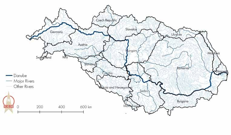
Best Practice Projects ............................................................................................................................................................................... 37
           MEASURES .......................................................................................................................................................................................................... 38
           Coop MDD ......................................................................................................................................................................................................... 40
           D2C – DARE TO CONNECT ................................................................................................................................................................................. 42
           Sava TIES ............................................................................................................................................................................................................. 44

V. DANUBEPARKSCONNECTED                                                                                                                                                                                                         46
DANUBEPARKS Association ....................................................................................................................................................................                                    47
Development and Structure of the Project ................................................................................................................................................                                       48
Water – Danube WILDisland Corridor .....................................................................................................................................................                                        49
Land – Danube Riparian Forest Corridor ..................................................................................................................................................                                       50
Land – DANUBE DRY HABITAT CORRIDOR ............................................................................................................................................                                                 51
Air – DANUBE FREE SKY .........................................................................................................................................................................                                 52
Fire – Involving People in Nature Conservation .........................................................................................................................................                                        53

VI. STRATEGIC PERSPECTIVES – GUIDING PRINCIPLES                                                                                                                                                                                 54
Guiding Principle 1: Promoting Ecological Connectivity across Bio-Geographic Regions ......................................................................................... 55
                                                                                                                                                                               56
Guiding Principle 2: Fostering Permeability among Macro-Regions .......................................................................................................................
Guiding Principle 3: Implementing Lighthouse Projects in Priority Areas within the Danube Region ............................................................................  57
Guiding Principle 4: Strenghtening Protected Areas and their Coherence as Key for Ecological Connectivity ............................................................         58
                                                                                                                                                                               59
Guiding Principle 5: Establishing Green Infrastructure to improve Ecosystem Services  ............................................................................................
Guiding Principle 6: Creating New Mechanisms for Cooperation, Dialogue and Participation towards a Danube Ecological Corridor .....................                            59
                                                                                                                                                                               60
Guiding Priniciple 7: Consolidating Basic Knowledge ...........................................................................................................................................
                                                                                                                                                                               61
Guiding Principle 8: Closing the Gap to Policy Makers .........................................................................................................................................
Guiding Principle 9: Building Capacities on Ecological Connectivity .......................................................................................................... 62
Guiding Principle 10: Fostering Continuity towards Green Infrastructure .................................................................................................... 62

ANNEX: REFERENCES & FURTHER READING                                                                                                                                                                                             64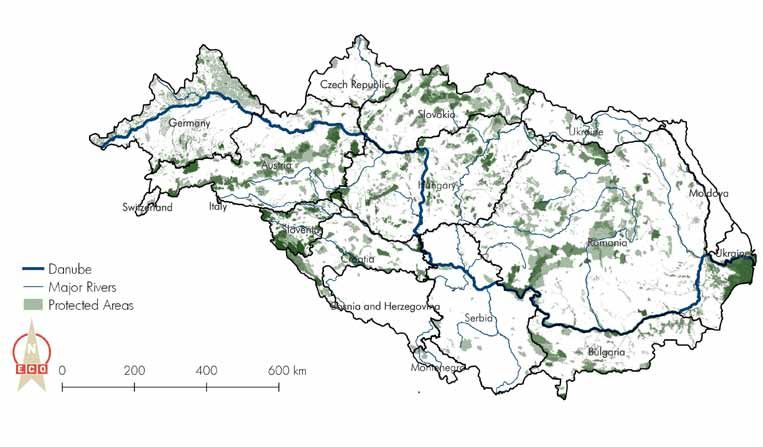
8

    Summary
    The improvement or rehabilitation of ecological con-          ciples were developed as part of this project and are
    nectivity is considered a fundamental aspect in order         a guideline for future activities related to ecological
    to reduce the loss of biodiversity and to preserve va-        connectivity.
    rious ecosystem services for the benefit of humans in
    the long term. Sectoral policies and a dynamic eco-           The first step was an analysis of the theory of ecologi-
    nomic development of the Danube River Basin (DRB)             cal connectivity, the current situation in the DRB with
    therefore represent a major challenge for the remai-          regard to corridors, barriers, existing strategies, the
    ning green spaces in the area. Within the framework           current projects in the DRB and their lessons learnt and
    of the implementation of the European Strategy for the        the results of the DANUBEparksCONNECTED project.
    Danube Region (EUSDR) the discussion gains momen-             Based on the output, general recommendations were
    tum. Activities are numerous and spread over the entire       formulated and put up for discussion which is intended
    DRB, often driven by local or national actors as well as      to provide orientation for further measures, projects
    NGOs.  Ecological connectivity and joint transnational        and strategies in the DRB.
    strategies on this topic are not yet fully on the political
    agenda.                                                       The guiding principles advocate long-term continuity,
                                                                  cross-sectoral and cross-border cooperation and the
    The three-year Interreg project DANUBEparksCON-               use of different protected areas categories and empha-
    NECTED (2017-2019) co-funded by the Interreg Da-              sise the increasing importance of capacity building, the
    nube Transnational Programme pursues the further              use of new technologies and new research approaches
    development of a Danube-wide corridor through the             and the right choice of funding pools.
    implementation of best practice examples in the ele-
    ments of air, water and land. The present guiding prin-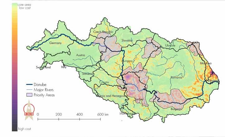
9

I. Ecological Connectivity – An Introduction
10

     I. Ecological Connectivity – An Introduction
     Ecological connectivity is becoming increasingly im-         The Upper DRB is inten-
     portant in a world shaped by human use. However, pri-        sively used by man, with
     or to the document focusing on ecological connectivity       the result that habitats are
     along the Danube, this chapter clarifies the principles.     ‘fragmented’ and someti-
     It deals with definitions, types and functions of ecolo-     mes lost. Extensive natural
     gical corridors and networks, their political anchoring      areas are changed over
     and the spatial reference of this document, the Danube       time by human activities
     River Basin (DRB).                                           such as deforestation. The
                                                                  land surface is decreased
     Conceptualising Ecological Connectivity                      or broken up into small
                                                                  habitat patches. Due to the
     All organisms need a certain type of place to live, i.e. a   fragmentation of their ha-
     habitat. For some species this habitat is very large, for    bitat (Figure 1), many spe-
     others it is rather small, depending on their ecological     cies have already disap-
     characteristics and territory size. Many species, how-       peared or may disappear
     ever, are not dependent on only one habitat, but on          from several regions in the
     several, be it due to the different seasons (e.g. birds),    future. As natural areas
     the time of day (e.g. food habitats for bats) or the re-     are fragmented, only small
     spective annual cycle (e.g. reproduction habitats for        populations of species can     Figure 1: The process of frag-
                                                                                                 mentation of natural areas (based
     migratory fish species or large migratory movements of       survive in the small and       on Van der Sluis et al. 2004)
     wildlife). The habitats and their connectivity must there-   isolated habitat patches.
     fore each have very specific qualities.                      Whether species survive or
11
not, often depends on a fragile balance. For example, However, if the species does not die out and the
a number of bad years, an epidemic disease or acci- overall population recovers, the now larger popu-
dents may result in the extinction of a species. lation is genetically much more uniform than the
population of approximately the same size before
Also, if the total population of a species is divided into the crisis as a result of the gene erosion that previ-
several isolated subpopulations, each comprising only ously occurred. Such a „gene erosion event” wi-
a few individuals, inbreeding depressions can lead to thout extinction is called a genetic bottleneck.
genetic impoverishment. In some cases, this can further
result in the complete collapse of the individual subpo- Good landscape connectivity will give species a bet-
pulations and thus to the extinction of a species, i.e. a ter chance of survival in the long term. Moreover, the
so-called gene erosion. impact of climate change, which may result in species
and habitats moving north in Europe, may be decrea-
White-tailed Eagle (Haliaeetus albicilla) - flagship species for the Danube © Donau-Auen National Park/Hoyer
sed if landscapes are well connected. The creation of
an ecological network in Europe is crucial for achie-
ving a global network of protected areas as envisa-
ged in the Convention on Biological Diversity (CBD).
Notwithstanding the necessity of connecting fragmen-
ted areas, those areas which were always isolated as a
result of physical geographical barriers should not be
connected, so as to preserve regional and genetical
differences. However, if these isolated areas are linked
by natural events, this should not be prevented either.
Together with so-called core areas, corridors form es-
sential components of ecological networks. An ecolo-12 I. Ecological Connectivity – An Introduction
gical network is a system of areas which are connected Kopački rit Nature Park © DANUBEPARKS/Kopački rit Nature Park
via ecological links or physical links. An ecological
network usually consists of ‘core areas’ (protected or
not), corridors, buffer zones and in some cases nature
development or restoration areas. A central role in
ensuring spatial cohesion of the network is therefore
played by corridors. Currently much effort is put into
the development of ecological networks, e.g. by means
of the construction of wildlife corridors and road cros-
sings or underpasses.
Nevertheless, it must be said that corridors and net-
works are not in all cases an improvement in conser-
vation. There are important limitations to the network
concept:
• endemic species that have developed over
thousands of years of isolation can be affected by
new competitors, new predators or new genes.
• invasive species can easily pass through new cor- The improvement or rehabilitation of ecological con-
ridors and damage natural habitats and species. nectivity is regarded as a fundamental aspect to reduce
• many species may not be able to pass the corri- the loss of biodiversity and to preserve various ecosys-
dors provided and for many species these corridors tem services for the benefit of humans in the long term.
might not be beneficiary (Gutleb et al. 2010). Sectoral policies and a dynamic economic develop-
ment of the DRB therefore represent a major challenge13
for the remaining green spaces in the area. Ecological nowledges in Article 10 the importance of landscape
connectivity and joint transnational strategies on this elements that enhance connectivity (“corridors”). Whilst
topic are not yet fully on the political agenda. building the EU ecological network Natura 2000, the
Directive encourages member states to include those
Political Framework for Ecological Connectivity landscape elements in their land-use planning and de-
velopment policies which they consider appropriate. A
The development of ecological networks and corridors more specialised agreement is the Convention on Mi-
is recognised as a positive policy for promoting nature gratory Species (CMS), also called Bonn Convention,
conservation both at European and global levels. The that obliges contracting parties to take effective mea-
concept of ecological networks was officially recognis- sures in conservation and management of the listed
ed in Europe as an important approach for biodiversity species in their migratory ranges. During the first years
conservation in the Pan-European Biological and of the new millennium, political attention for the deve-
Landscape Diversity Strategy (PEBLDS). The PEBLDS lopment of ecological networks on a global level has
was endorsed in 1995 by 54 states in Europe and calls increased considerably.
for the development of the Pan European Ecological
Network (PEEN) in order to achieve the effective im- At the World Summit on Sustainable Development in
plementation of the Convention of Biological Di- Johannesburg (2002) the importance of the develop-
versity (CBD) at the European level. The PEEN wants ment of regional and national ecological networks and
to promote a Europe where nature is connected and corridors as a way to achieve sustainable development
where all European governments are actively engaged was confirmed in the Plan of Implementation. Finally,
in establishing and maintaining a pan-European eco- during the Seventh Conference of Parties of the Con-
logical network. vention on Biological Diversity (2004) ecological net-
works were incorporated in the work programme on
The Habitats Directive of the European Union protected areas as a key conservation strategy.
(1992), which responds to the Berne Convention, ack-14 I. Ecological Connectivity – An Introduction
Functions and Types of Corridors movements are restricted to short distances (up to a
few kilometres) for vertebrates, or to tens of kilometres
Corridors can be classified into three classes according for wider ranging species. Good examples of species
to the functions that they fulfil. Commuting corridors using commuting corridors are badgers and bats.
are used for regular movements from resting/breeding Migration corridors are used for annual migratory
sites to foraging areas. A commuting corridor links movements from one resource area to another (e.g.
elements that have a different function within the from breeding to wintering ground). The biological
home range of a species. It supports daily movements process of migration is a principal activity for any
between these elements and acts beneficially because species groups. The most well-known are bird and fish
it reduces predation risk, offers guidance and facilitates migrations. In their journey from one resource area
movement through the landscape. Normally these to another, some species will benefit from the use of
The Danube bend, connecting the the Danube corridor and the Carpathians © DANUBEPARKS/Duna-Ipoly National Park15
corridors. This can be in the shape of a continuous Figure 2: Corridor types
(based on Bennett 2003)
linear pathway (e.g. riparian fish species). More often
the pathway will consist of a set of areas used during
a) Line Corridor
migration as ‘stopover’ places (e.g. marshes for
waterfowl and waders). Dispersal corridors are used
for a one-way movement of an individual (usually a
juvenile) or population from either its site of birth (for
juveniles) or its former breeding area to a new breeding b) Stepping Stones
area. Dispersal is an essential process leading to the
immigration of individuals into other populations or to
(re)colonisation of suitable habitat patches. In order
to differentiate between individuals and populations,
c) Landscape corridor
dispersal corridors may be sub-divided into three types;
one step dispersal corridors, reproduction corridors
and range expansion corridors. In addition to the
classification according to functionality, corridors can
be classified into three classes according to the shape provide a continuous connection of favoured habitat.
that they have: line, steppingstone and landscape
corridors (Figure 2). Landscape connectivity may be Terminology
achieved in two main ways: (a) by managing the entire
landscape mosaic to facilitate movement; or (b) and (c) Ecological connectivity, ecological networks, ecologi-
by maintaining specific habitats that assist movement cal corridors, green infrastructure (GI) and much more
through an inhospitable environment. These patterns – all these terms are frequently used in publications,
of habitat may be in the form of (b) steppingstones of strategies and reports and also in this document, but
various sizes and spacing, or (c) habitat corridors that do not mean exactly the same thing. Therefore, here is16 I. Ecological Connectivity – An Introduction
a brief overview of the most important definitions of key rivers, streams, ponds and lakes. In combination with
terms in the context of ecological connectivity and GI. land spaces, it is often referred to as blue-green infra-
structure.
Ecological connectivity refers to the spatial and Ecological corridors can be considered as part of an
temporal extent to which animals or plants and rela- ecological network model that describes a functional
ted ecosystem functions can move between different zone linking several natural zones for a group of spe-
habitat patches. Ecological corridors, greenways or cies dependent on a single environment. This corridor
steppingstones facilitate connectivity (Chester and Hilty therefore connects different populations and allows the
2010). Ecological connectivity describes how well an migration of species between them. These corridors
ecological network functions. However, the concept is are also sometimes named “eco-corridors”, “lands-
still controversially discussed as there is no consensus cape corridors” or “greenways”. Ecological corridors
on a common definition, ranging from enabling the usually have a clear conservation and species focus
movement of specific species along linear elements to and are the backbone of all ecological networks.
the establishment of large regional connections to faci- A widely accepted and cited definition for ecological
litate ecological flows and the migration of species bet- networks is proposed by Bennett (2006): “An ecologi-
ween different parts of the landscape (Walzer 2016). cal network is regarded as a coherent system of natural
and/or semi-natural landscape elements that is confi-
Green Infrastructure refers to both the concept as Human pressure by transport and energy infrastructure on the Danube corridor in Baviara
© DANUBEPARKS/Stadt Ingolstadt/Bäuerlein
such and to structures in the landscape. It is thus aDANUBEPARKS/Stadt
stra- Ingolstadt/
tegically planned network of natural or semi-natural
areas with different natural characteristics providing a
wide range of ecosystem services to a wide range of
beneficiaries (European Commission 2013).
Blue infrastructure is often used in an urban context
and is a collective term for all water elements including17
gured and managed with the objective of maintaining valley of Switzerland (Engadin) and a very small part of
or restoring ecological functions as a means to conser- Italy (the source of the Drava river). With a total area of
ve biodiversity while also providing appropriate oppor- 801,463 km², the DRB is Europe‘s second largest river
tunities for the sustainable use of natural resources”. basin and the world‘s most international river basin.
More than 81 million people of different cultures and
This definition is widely used and although slight- languages call the Danube Basin their home, for cen-
ly modified, all definitions emphasise the need for a turies they have been interconnected through the wide-
“system”, to have a “coherent” network and “mainte- ly ramified water system of the Danube. All countries
nance of ecological functions” and an interaction or sharing over 2,000 km² of the DRB and the European
link between individual patches (Zhang 2012). These Union are contracting parties of the ICPDR.
networks require structural models or concepts on how
to describe, analyse, plan or implement them including Map 2: The Danube River Basin, data source: eurostat, ESRI
GI models, ecological corridor concepts or greenways.
The Danube River Basin
For this document, the Danube River Basin (DRB, Map
1) as used by the International Commission for the Pro-
tection for the Danube River (ICPDR) will serve as the
reference area.The boundaries go hand in hand with
the catchment area of the Danube river and compri-
se the following countries or parts thereof: Germany,
Czech Republic, Austria, Slovakia, Hungary, Romania,
Bulgaria, Ukraine, Moldova, Servia, Bosnia and Her-
zegovina, Montenegro, Croatia, Slovenia as well as a Data source: eurostat, ESRI18
II. Ecological Corridors in the Danube River Basin19
II. Ecological Corridors in the Danube River Basin
This chapter first identifies the existing elements of Box 1: IUCN Protected Area Categories
green infrastructure (GI) in the Danube River Basin
(DRB) on land, water and air. Based on these elements, Category Ia – Strict Nature Reserve
Category Ib – Wilderness Area
the four main ecological corridors are then described.
Category II – National Park
The document itself focuses on the Danube River and Category III – Natural Monument or Feature
its main tributaries, however, it is crucial to understand Category IV – Habitat/Species ManagementArea
the connectivity to other habitats and to other main Category V – Protected Landscape/Seascape/Area
corridors and to always see the Danube as an element Category VI – PA with sustainable use of natural resources
in a more or less interconnected environment.
forest areas such as the Bavarian Forest and Šumava
Main Elements of Green Infrastructure on Land constitute huge protected areas. The Danube Delta in-
cludes a large area, most of which is IUCN Category
Protected Area Network V. In addition, several Natura 2000 sites have been
established along the major rivers such as the Danube
The backbone of GI on land (as well as on water) is itself, the Drava, the Prut, the Sava and the Tisza. Howe-
the network of protected areas within the DRB. Ac- ver, protected areas are often not sufficient to fully cover
cording to the World Database of Protected Areas, the- all relevant ecosystems and habitat types necessary for
re is a large number of more than 12,395 protected connectivity, as, with the exception of Natura 2000,
areas within the DRB (Map 3). Most of the protected protected areas are often selected not for ecological
areas, especially the larger ones, are located on higher representativeness but for other (e.g. political) reasons
mountains such as the Alps, the Dinaric Alps, the Car- (Broggi et al. 2017). Nevertheless, this network forms
pathians and the Balkan Mountains. At lower altitudes, the core of any GI network. The Natura 2000 sites20 II. Ecological Corridors in the Danube River Basin
Map 3: Protected Area Network of the Danube River Basin.
Data source: eurostat, WDPA21
Map 4: River System of the Danube River Basin
Data source: eurostat, Danube GIS22 II. Ecological Corridors in the Danube River Basin
are considered as the contribution from the EU Member Main Elements of Green Infrastructure: Water
States to the Berne Convention. Therefore, this protected
area category is not present in Bosnia and Herzegovi- With regard to water connectivity, the Danube itself
na, Moldova and Serbia. However, these countries still and its most important tributaries (Map 4, Table 1) are
have great potential for establishing new protected are- considered key elements of GI. In addition, larger lakes
as due to their large natural areas. complement the Blue Infrastructure of the Danube. Given
the detailed and extensive mapping and activities of
Large Forest Areas and Extensively Managed Land ICPDR, this section only indicates the main river system
and the main lakes in the area. The main lakes (surface
Outside protected areas, large forest areas play an area > 100 km²) in the DRB are Lake Neusiedl, Lake
important role as GI, if forest use is not too intensive. Balaton, Lake Sinoe, Lake Golovita, Lake Zemeica, Lake
Areas with spruce monoculture or intensive deforestati- Razelm, and Ozero Ialpug. Of these lakes, Lake Balaton
on with clear cuts are regarded as ecological barriers. with an average depth of 3,60 m, is the deepest one.
Apart from large forest areas – some of them adjacent In addition, the Danube Delta is the most important
to alluvial forest to the Danube and its tributaries – are- blue-green infrastructure of this system. Since rivers also
as with rather extensive agriculture, characterised by form transnational borders, these blue infrastructures are
small patches of meadows, fields and hedges, play a often of transnational importance. Management issues
big role. On land, there are some major key infrastructu- cannot only be dealt with at national level. This has
res or ecological corridors of transnational importance. already led to the creation of interesting initiatives such
The global land cover analysis shows rather few extensi- as the Green Belt connecting 24 countries, the planned
vely cultivated areas, mainly in mountainous areas. This 5-country Biosphere Reserve Mura-Drava-Danube or the
reflects good agricultural production capacities in the trilateral Donau-March-Thaya-Auen Ramsar Site.
lowlands from the east of Vienna to the Carpathians.
Intensive agricultural land is regarded as a barrier.23
Table 1: Danube and major rivers in the Danube River Basin
Rivers Mouth at Length [km] Size of Average Morava 1,103 430 37,444 232
Danube catchment discharge (Serbia)
[rkm] [km2] [m3/s] Timok 846 180 4,63 31
Danube 0 2,78 801,463 6,46 Jiu 694 339 10,08 86
Lech 2,497 254 4,125 115 Iskar 636 368 8,684 54
Naab 2,385 191 5,53 49 Olt 604 615 24,05 174
Isar 2,282 283 8,964 174 Yantra 537 285 7,879 47
Inn 2,225 515 26,13 735 Arges 432 350 12,55 71
Traun 2,125 153 4,257 150 Ialomita 244 417 10,35 45
Enns 2,112 254 6,185 200 Siret 155 559 47,61 240
Morava 1,88 329 26,658 119 Prut 132 950 27,54 110
(March)
Rába – 311 10,113 88
Main Elements of Green Infrastructure: Air
Vah 1,766 398 18,296 161
Hron 1,716 278 5,463 55
Ecological connectivity from an aerial perspective is a
Ipoly 1,708 197 5,108 22 challenging topic. Key elements for ecological connec-
Sió 1,498 121 9,216 39 tivity in the air are the migratory routes of birds and the
Drava 1,382 893 41,238 577 associated main resting spots of migratory birds, which
Tisza 1,214 966 157,186 794 are mostly wetlands. In addition, the Danube itself is
Sava 1,17 861 95,719 1,564 also a major flyway for certain species. Map 5 shows
Timis 1,154 359 10,147 47
the main bird migration routes for selected species in
the DRB. Hortobagy in Hungary is an important stop-24 II. Ecological Corridors in the Danube River Basin
Map 5: Bird Migration in the Danube River Basin
Map 7: Bird Migration in the Danube River Basin
redstart (Phoenicurus phoenicurus)
crane (Grus grus)
swallow (Hirundo rustica)
red kite (Milvus milvus)
lesse spotted eagle (Clanga pomarina)
white stork (Ciconia ciconia)
Data source: eurostat, NABU Crane Centre25
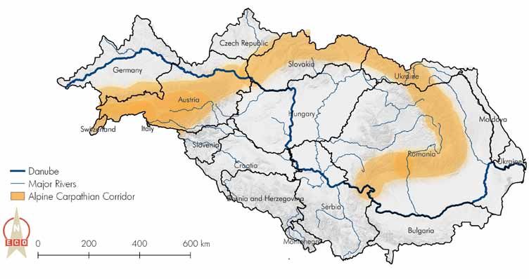
Map 6: Alpine Carpathian Corridor
Data source: eurostat, ESRI26 II. Ecological Corridors in the Danube River Basin
over for cranes. Other important sites are the Danube four main corridors were identified:
Delta, Lake Balaton and Lake Neusiedl.
One of the key transnational infrastructures and an im-
Although these corridors are quite flexible and may portant ecological network is the Alpine Carpathian
shift due to habitat changes, climate or wind direction Corridor (Map 6). It follows the Alps and the Carpathi-
changes, further investigation of these routes appear es- ans, and many species of higher altitudes occur in both
sential. The Convention on Migratory Species (CMS) mountain areas. The Alps and Carpathians are home
aims to protect migratory species throughout their range, to a variety of large wild animals such as deer, lynx,
which is particularly important for birds and a key is- wolves and bears – species that today are highly de-
sue for transboundary or international cooperation (e.g. pendent on humans for their natural habitat. The corridor
the CMS Agreement on the Conservation of African- between the Alps and the Carpathians is a traditional
Eurasian Migratory Waterbirds) (Jongman et al. 2011). migration route for wildlife. This corridor not only con-
Flyways of birds include the routes (and their man-made nects the eastern border of the Alps with the Little Carpa-
barriers such as power lines), stopovers and feeding thians of Slovakia, but also crosses a highly dynamic Eu-
places as well as the respective final destinations (Boere ropean region between the cities of Bratislava, Sopron
et al. 2006). The DRB plays an important role as it has and Vienna. This provides a good knowledge base for
core resting and feeding places. ecological connectivity in the Carpathians (e.g. Kutal
2013; Maanen et al. 2006, CEEB 2011; Deodatus et
However, the level of knowledge is still quite limited, al. 2013; Andel et al. 2010). The European Beech Fo-
and the question of flyways has been largely neglected rest Network, which was recently established as a result
in the discussion about GI and ecological connectivity. of the approval of the international World Heritage Site,
also addresses the need to ensure permeability and im-
Main Corridors in the Danube River Basin prove corridors for typical and rare beech forest species
with high demands on ecological habitats. Examples of
Based on the analysis of the GI elements in the DRB, important species in Central Europe are the barbastelleII. Ecological Corridors in the Danube River Basin 27
Map 7: Dinaric Alps Corridor
Data source: eurostat, ESRI28
bat, the Alpine longhorn beetle and the white-backed ring the Cold War. Conservationists aim to create a
woodpecker (Kirchmeir & Kovarovics 2016). continuous, pan-European nature reserve stretching from
northern Finland to the Black Sea along the route of the
In addition to the above, the Dinaric Alps Corridor former Iron Curtain.
(Map 7) is an important north-south connection for large
mammals (Proschek 2005). The corridor is reflected in The Danube Corridor is one of the most valuable wa-
the network of protected areas of Slovenia and Croatia, ter and earth corridors in the DRB, as it is the lifeline of
but not yet in Bosnia-Herzegovina and Serbia. Currently, the DRB, which runs through the centre of the microre-
many Balkan countries (Montenegro, Macedonia, Cro- gion and also crosses more developed and industria-
atia, Serbia) are concentrating on expanding and con- lised parts. Floodplain forests, (semi-wild) islands, dry
solidating the network of protected areas (Natura 2000 habitats and wetlands are valuable GI elements along
and Emerald Sites). The area is an important refuge for the Danube and its major tributary rivers, not only fulfil-
large carnivores (lynx, bear, wolf) and other migratory ling ecological functions but also providing several eco-
species. Through the Alps and the Danube with its tri- system services such as flood protection or recreation.
butaries, the Dinaric Arc ecoregion has many points of Urbanisation and economic development pose the gre-
contact with other European macro-regions. atest challenges, especially in the lower watercourses
(Filipovic & Petrovic 2015).
The European Green Belt follows the route of the for- Iron Gate Dam © DANUBEPARKS/Frank
mer Iron Curtain and connects national parks, nature
parks, biosphere reserves and transboundary protected
areas as well as unprotected valuable habitats along or
across the (former) borders. This border strip, which is
more than 12,500 km long and between 50 and 200
m wide, has become a refuge for endangered species,
as nature was able to develop here, undisturbed, du-29 III. Barriers and Gaps in the Danube River Basin
30

     III. Barriers and Gaps in the Danube River Basin
     In this chapter, barriers and gaps in the Danube River        Map 8: Cultivated and artifical land cover
     Basin  (DRB) on land, water and air as well as know-
     ledge gaps are pointed out. Furthermore, the fragmen-
     tation and connectivity between the main corridors is
     analysed. The result is a map marking priority areas
     for pilot projects in the field of ecological connectivity.

     Barriers and Gaps on Land

     The natural relief of a landscape, especially mountain
     areas, can become a barrier for many species. The
     main mountain ranges in the DRB are the Alps, the Ta-                                    Data source: eurostat, ESRI, GLC 2000
     tras, the Dinaric Alps, the Balkan Mountains and the
     Carpathians. Apart from the peaks of these mountain
     ranges, however, these are mostly core areas for GI and       the barriers to ecological connectivity in the Carpathians
     together with the Danube and the network of protected         and Marschall et al. (2012) of the barriers and gaps of
     areas form the backbone of GI.                                the Green Belt.

     In addition to natural barriers, there are several            Barriers and Gaps in the Water
     anthropogenic barriers such as airports, highways,
     hydropower plants and dense populated areas (Maps 8           In addition to hydropower plants, the river system is
     and 9). Favilli et al. (2014) provide a good analysis of      also negatively influenced by artificial canal structures
31
and anthropogenic negative effects on the hydraulic Map 9: Technical barriers in the Danube River Basin
properties. In the DRB, there are over 700 dams and
weirs only at the main tributaries. The ICPDR has been
continuously working on water connectivity for many years
through the EU Water Framework Directive. Protected
areas themselves have contributed to the revitalisation of
lateral connectivity. The restoration potential and status
are known at macro-regional level. However, so far, the
main river has been in the foreground, while tributaries
are only gradually receiving more attention.
Barriers and Gaps in the Air
Data source: eurostat, ESRI
In the air, the main barriers are connected to high voltage (Sinnett et al. 2016).
power lines and wind farms, leading to significant
mortality of migratory birds. Table 2 gives an overview of the available information
on ecological connectivity in the individual DRB coun-
Barriers and Gaps in Knowledge tries and about the degree of integration into national
planning.
Information concerning the current status of ecological
connectivity is very dispersed and varies a lot between Austria and Germany have carried out numerous studies
the different DRB countries (Kostyanzski 2013). Similar and projects to identify corridors and barriers for different
challenges were also reported from the EUSALP area habitats and species. In certain sectors, the results are
(Plassmann et al. 2016) and other studies that wanted integrated into specific spatial plans, e.g. Waldfach-
to give an overview of ecological connectivity or GI plan (Forest Management Plan) in Austria, which are32 III. Barriers and gaps in the Danube River Basin
drawn up on a voluntary basis, mostly on the initiative logies if the issue of connectivity is to be addressed
of forest owners (BMNT 2019), or considerations of at transnational or macroregional level. As a result of
wildlife corridors in transportation infrastructure planning this heterogeneity, transnational information is scarcely
in Germany (Rudolph et al. 2010).
Table 2: Information available in the Danube River Basin
In addition, the Czech Republic, Slovakia and Hungary
have good concepts for national ecological corridors Trans- Corri- Quality Barriers Legally Integra-
bound- dors of corri- map- integra- tion into
systems (TSES), which need to be considered in spatial ary known dors ped ted spatial
planning. This also provides a national legal basis for activity known planning
ecological corridors. However, no detailed information AUT
on the quality of these corridors or the final degree of CZE
implementation could be obtained during the research.
DEU
Most countries have at least an overview of their main HUN
ecological corridors at national level and detailed stu- SVK
dies for specific areas (e.g. locally relevant corridors) MDA
or species (e.g. regional lynx corridors). However, eco- SRB
logical connectivity and corridors are rarely legally im- SVN
plemented or integrated into spatial planning. In most ROU
cases, ecological connectivity is only considered as a
UKR
cross-cutting issue. The quality of the corridors in many
BGR
countries remains unclear, either because no data have
been collected, data are not publicly available or were HRV
only published in the national language. This underlines Available information and activities regarding ecological connectivity in individual coun-
tries of the DRB (green: good information/frequent activities, yellow: medium informati-
the need to identify common standards and methodo- on level/some activities, orange: no information available/no activities)33
available and can only be generated through the use lows the combined visualisation of animal needs and
of global data sets and local or national information, landscape realities in different scales and offers an in-
which is often lacking. Information on TSES in Slovakia sight into the matrix of connectivity potential in the Alps.
and the Czech Republic could also be of high relevance
for other countries. When it comes to the issues covered, Connectivity of Main Corridors in the DRB
it is very clear that water-related connectivity issues are
mostly dealt with at a transnational level, providing com- In a study on ecological connectivity in the DRB,
prehensive information on connectivity and barriers. As commissioned by the Bavarian State Ministry of the
far as the country is concerned, the information usually Environment and Consumer Protection PA 6 Leader of
remains at national level, with corridors sometimes even EUSDR, ArcGIS was used to produce a map showing
ending at the national border. Most connectivity pro- the degree of fragmentation and the spatial distribution
jects, laws or actions are strongly related to terrestrial of step stones (Map 10). Data from the Global Land
connectivity, while air connectivity is an issue that is not Cover 2000 database was divided into three catego-
yet mentioned anywhere. ries: natural (extensively used and natural vegetation),
intensive (cultivated and managed areas) and anthro-
One way of generating transnational knowledge and pogenic (artificial and associated areas). Natural are-
making it accessible is shown by the European project as and protected areas were grouped together as core
„ECONNECT – Restore the Web of Life“, funded by the areas (green). The lowest “cumulative cost difference” is
European transnational cooperation (ETC) Alpine Space shown in light green. The changing colour gradient from
Programme. The vision was to analyse the capability of light green to dark violet shows an increasing effort to
the Alpine range to serve as an ecological continuum get to the next core area.
and to identify and visualise areas in which the ecologi-
cal network can be improved. For this purpose, the web While greenish areas have a small distance from each
application JECAMI was developed. The „Joint Ecolo- other, yellowish to violet areas indicate areas in which
gical Continuum Analyzing and Mapping Initiative” al- no or only very isolated patches of (semi-)natural areas34 III. Barriers and gaps in the Danube River Basin
Map 10: Priority areas for actions on ecological connectivitiy in the Danube River Basin
1
5 4
2
3
Data source: GLC 200035
can be found. In the analysis, no linear barriers (roads, a major barrier for the connection of the Alps and the
railroads) were considered. Carpathians.
2. The Pannonian Lowlands in the border region of
The results show only a broad overview at macro-regi- Croatia, Serbia and Hungary are areas that are
onal level. It is important to note that this analysis does dominated by large intensive agricultural areas. The
not replace concrete local assessment and modelling Green Belt and the Danube are amongst the few key
for specific species and local barriers. However, the re- GI in the area.
sults can be used at a strategic level when deciding on 3. The lowland areas between the Danube and
the selection of pilot regions, the allocation of budgets the Carpathians in Romania and Bulgaria are also
for connectivity projects or the definition of transnational dominated by important agricultural areas. The
corridor systems. tributaries to the Danube main river represent important
local elements for connectivity between the Danube and
Isolated areas in more intensive/fragmented areas are the Carpathians.
most likely to have a higher significance in terms of 4. The area where Ukraine, Romania and Moldova
loss of the area. While areas with cost values (green) share the border has some major barriers and is located
offer many different possibilities for wildlife migration along the main Alps-Carpathians Corridor.
(alternative routes), a loss of natural elements in isolated 5. The area along the borders of Slovakia, Ukraine,
areas (yellow-violet) can trigger complete isolation. Hungary and Romania has some major barriers located
Nevertheless, the analysis clearly shows where the directly along the main corridor within the Carpathians.
existing main corridors are and gives a broad indication
of areas with low connectivity, especially in these 5 These areas have also been selected as priority areas
priority areas (3 of which are along the Danube, 2 in for possible pilot projects in the field of ecological con-
the mountains): nectivity. The criteria degree of isolation, transboundary
aspects (at least 2 countries), location along one of the
1. The area along the border of Slovakia and Austria is identified main corridors and data availability were cha-
racteristic for the selection of the areas.36
IV. Enhancing Ecological Connectivity – Strategies & Projects37
IV. Enhancing Ecological Connectivity – Strategies & Projects
Studies, initiatives and projects on green infrastructures The Priority Area 06 of EUSDR “To preserve biodiversity,
(GI) or ecological connectivity are abundant. This sec- landscapes and the quality of air and soils” comprises
tion provides a general overview of strategies, funding the development and implementation of a GI at macro-
instruments and best practice projects on ecological regional level. The topics range from restoring degraded
connectivity in the Danube River Basin (DRB). ecosystems to eradicating invasive species and securing
viable populations of migratory fish species.
Relevant Strategies and Policies
The Danube River Protection Convention (DRPC)
The following section lists the relevant strategies and is the major legal instrument for cooperation in trans-
conventions at macro-regional and European level and boundary water management in the DRB. The Conven-
gives a brief overview of their link to ecological con- tion was signed in Sofia (Bulgaria) on June 29, 1994
nectivity. and came into force in 1998. The main objective of the
Danube River Protection Convention is to ensure the sus-
Target 2 of the EU 2020 Biodiversity Strategy requires tainable and equitable management and use of surface
that by 2020 “ecosystems and their services are main- and groundwater in the DRB.
tained and enhanced by establishing GI and restoring
at least 15% of degraded ecosystems”. To support this The International Commission for the Protection
process across Europe, the European Commission adop- of the Danube River (ICPDR) was established to im-
ted the strategy in 2013. plement the DRPC. The ICPDR is formally comprised of
the Delegations of all Contracting Parties to the Danube
The EU Strategy for the Danube Region (EUSDR) River Protection Convention but has also established a
aims to strengthen EU policies in the Danube region. framework for other organisations to join. Since 2009,38
the Danube River Management Plan (DRMP) has provi- Best Practice Projects
ded a roadmap for this. It contains a Joint Programme
of Measures and aims to fulfil the EU Water Framework Several projects have already been initiated in the DRB
Directive (WFD). The ICPDR is currently working on an to promote ecological connectivity. The following pa-
updated version of the DRMP. The ICPDR also imple- ges describe four successful projects selected for their
ments the EU Flood Directive (EFD). practice-oriented measures and their direct influence on
connectivity. MEASURES deals with a migratory flag-
The Habitats and Birds Directives and their imple- ship species whose survival depends on connectivity,
mentation through the Natura 2000 network are key whereas COOP MDD is an example for a transnatio-
instruments for the implementation of the ecological con- nal protected area network. DaRe to Connect shows a
nectivity at European level. These directives emphasise successful project that tries to close the last gaps of the
the coherence and connectivity of the network and re- historically grown green belt and Sava TIES identifies
quire member states to comply with the requirements. the negative aspects of connectivity, such as the rapid
The Natura 2000 network is therefore seen as the back- dispersal of invasive species.
bone of a European GI network.
Box 2: Audience Polling at the DPC conference, Part I
The White Paper on Integrated Sustainable Develop- These best practice projects were presented at the final
ment of the DRB (Winiwarter & Haidvogel 2015) identi- DANUBEparksCONNECTED conference in Novi Sad in
June 2019. The audience was asked whether the selec-
fies important gaps in knowledge, principles and topics
tion of the projects was justified. 60% found that these
of inter- and transdisciplinary long-term research for the
projects have a major impact on ecological connectivity
sustainable development of the DRB. It contains recom- in the DRB. 25% already knew about the projects and
mendations for political decision-makers on important 70% had at least heard about them. 76% of the audience
prerequisites and organisational measures at national thought that these projects represent key aspects of the
and European level. activities that have been implemented to enhance ecolo-
gical connectivity in the DRB.39
Sturgeon hatchery © Daniel Trauner
FACTS & FIGURES
Interreg Danube Transnational Programme
Term: Jun 2018 – May 2021
Budget: 2,513,000€
Partners: 12 (Lead Partner: BOKU Vienna)
AUT|BGR|HUN|HRV|ROU|SLV|SRB|SVK
MEASURES
Managing and Restoring Aquatic Ecological Corridors for Migratory Fish in the Danube River Basin
The Danube is home to some of the most important spawn, such as dams or hydropower plants. Only a
sturgeon and other migratory fish populations (e.g. coordinated approach can prevent the further decline or
shads, barbel, nose etc.). The largest and possibly most the total disappearance of these species, whose health
iconic among these species are the sturgeons, a key reflects the overall well-being of the entire Danube eco-
element of life within the river basin. Bulgaria and Ro- system itself. MEASURES aims to create safe corridors
mania hold the only – still – viable populations of wild on the entire Danube and its major tributaries for the
sturgeons in the European Union which have faced a native fish, which migrate along the river as an essen-
dramatic decline in the past decades due to man-made tial part of their reproductive life-cycles. By working to
barriers that prevent their migration and their ability to protect and increase their numbers, MEASURES will beYou can also read