Global maps of cropland extent and change show accelerated cropland expansion in the twenty-first century
←
→
Page content transcription
If your browser does not render page correctly, please read the page content below
Articles
                                                                                                       https://doi.org/10.1038/s43016-021-00429-z

Global maps of cropland extent and change show
accelerated cropland expansion in the twenty-first
century
Peter Potapov 1 ✉, Svetlana Turubanova 1, Matthew C. Hansen 1, Alexandra Tyukavina 1,
Viviana Zalles1, Ahmad Khan1, Xiao-Peng Song 2, Amy Pickens1, Quan Shen 1 and Jocelyn Cortez                                                             3

Spatiotemporally consistent data on global cropland extent is essential for tracking progress towards sustainable food produc-
tion. In the present study, we present an analysis of global cropland area change for the first two decades of the twenty-first
century derived from satellite data time-series. We estimate that, in 2019, the cropland area was 1,244 Mha with a correspond-
ing total annual net primary production (NPP) of 5.5 Pg C year−1. From 2003 to 2019, cropland area increased by 9% and crop-
land NPP by 25%, primarily due to agricultural expansion in Africa and South America. Global cropland expansion accelerated
over the past two decades, with a near doubling of the annual expansion rate, most notably in Africa. Half of the new cropland
area (49%) replaced natural vegetation and tree cover, indicating a conflict with the sustainability goal of protecting terres-
trial ecosystems. From 2003 to 2019, global per-capita cropland area decreased by 10% due to population growth. However,
the per-capita annual cropland NPP increased by 3.5% as a result of intensified agricultural land use. The presented global,
high-resolution, cropland map time-series supports monitoring of natural land appropriation at the local, national and interna-
tional levels.

G
        lobal population growth and increasing standards of living            metrics that characterize land surface phenology. These metrics
        inevitably cause the expansion and intensification of global          were used as independent variables for a machine-learning classi-
        agricultural land use to fulfil growing demands for food, biofuel     fication to map global cropland extent. The classification models
and other commodities1–3. In turn, agriculture expansion and intensi-         were locally calibrated using extensive training data collected by
fication threaten ecosystem functioning and lead to species extinction        visual interpretation of freely available, high-spatial-resolution sat-
through habitat loss and fragmentation3–6. The United Nations’ 2030           ellite images. We used a probability sample, stratified based on the
Sustainable Development Goals (SDGs) call for balancing increas-              Landsat-based global cropland maps, to estimate cropland area and
ing agricultural production with maintenance of ecosystem services7.          its associated uncertainty, and to analyse pathways of land-use con-
Implementation of SDGs to improve food security, protect freshwa-             version. Sample reference data were collected through visual inter-
ter and terrestrial ecosystems, and mitigate climate change requires          pretation of Landsat time-series data and higher-spatial-resolution
national policies and international cooperation that are based on con-        satellite images. Cropland maps were integrated with the Moderate
sistent, independent and timely data on agriculture extent and pro-           Resolution Imaging Spectroradiometer (MODIS)-derived annual
ductivity8,9. Spatiotemporally consistent satellite observations provide      net primary production (NPP)20 as a proxy variable for analysing
the most accurate and cost-effective solution for global agricultural,        crop productivity. The analysis was performed in 4-year epochs
land-use mapping and monitoring10. Satellite data have been shown             (2000–2003, 2004–2007, 2008–2011, 2012–2015 and 2016–2019).
to enable national and global agriculture mapping11–17. However, no           We created one cropland map per epoch (five maps in total), here-
globally consistent, multidecadal, cropland time-series data at locally       after referred to by the last year of the interval (for example, the
relevant spatial resolutions (30 m per pixel) exist to date.                  2019 map represents the 2016–2019 epoch).
    In the present study, we present a global cropland extent and
change dataset that can contribute to monitoring national and global          Results and discussion
progress towards SDGs. We define cropland as land used for annual             Cropland area and change. Using probability sample data, we esti-
and perennial herbaceous crops for human consumption, forage                  mated the 2019 global cropland area to be 1,244.2 ± 62.7 Mha (the
(including hay) and biofuel. Perennial woody crops, permanent pas-            uncertainty represents the 95% confidence interval (CI)). Of the
tures and shifting cultivation are excluded from the definition. The          global cropland area, 55% is in Eurasia, 17% in Africa, 16% in North
fallow length is limited to 4 years for the cropland class. Our defini-       and Central America, 9% in South America and 3% in Australia and
tion is largely consistent with the arable land category reported by          New Zealand (Table 1; see Extended Data Fig. 1 for region bound-
the Food and Agriculture Organization (FAO) of the UN18. To cre-              aries). During the first two decades of the twenty-first century,
ate the cropland dataset, we utilized the consistently processed 30 m         global cropland area increased by 101.9 ± 45.1 Mha, equivalent to
spatial resolution Landsat satellite data archive19 from 2000 to 2019.        9% of the 2003 cropland area (Fig. 1). The largest cropland expan-
The Landsat time-series data were transformed into multitemporal              sion was observed in Africa (by 53.2 ± 39.4 Mha, or 34%). South

Department of Geographical Sciences, University of Maryland, College Park, MD, USA. 2Department of Geosciences, Texas Tech University, Lubbock,
1

TX, USA. 3Centro Interdisciplinario de Investigaciones y Estudios sobre Medio Ambiente y Desarrollo, Instituto Politécnico Nacional, Ciudad de México,
México. ✉e-mail: potapov@umd.edu

Nature Food | VOL 3 | January 2022 | 19–28 | www.nature.com/natfood                                                                                      19
Articles                                                                                                                                                   Nature Food

Table 1 | The regional and global map-based and sample-based cropland and cropland dynamics areas
                   Cropland area 2000–2003 Cropland area 2016–2019                             Net change 2003–2019        Gross gain 2003–2019           Gross loss 2003–2019
                   (MHa)                   (MHa)                                               (MHa)                       (MHa)                          (MHa)
Africa
  Map              142.6                                          189.6                        47.0                        62.1                           15.1
  Sample           155.1 (39.8)                                   208.3 (47.4)                 53.2 (39.4)                 71.5 (33.9)                    18.3 (19.4)
South-west Asia
  Map              224.9                                          250.9                        26.0                        42.6                           16.6
  Sample           237.3 (20.6)                                   244.8 (21.4)                 7.5 (11.7)                  29.3 (7.1)                     21.8 (9.1)
Australia and New Zealand
  Map              42.8                                           46.0                         3.2                         5.2                            2.0
  Sample           37.3 (2.7)                                     40.3 (3.5)                   3.0 (2.2)                   4.0 (2.1)                      1.1 (0.2)
South-east Asia
  Map              172.9                                          184.5                        11.6                        30.9                           19.3
  Sample           192.7 (20.9)                                   191.1 (21.8)                 −1.6 (8.6)                  23 (4.1)                       24.6 (7.4)
Europe and North Asia
  Map              234.7                                          233.7                        −1.1                        29.5                           30.5
  Sample           252.3 (21.3)                                   253.2 (20.7)                 0.9 (6.8)                   25.3 (6.2)                     24.4 (2.5)
North and Central America
  Map              196.9                                          201.5                        4.6                         21.3                           16.7
  Sample           192.1 (12.4)                                   193.9 (14.4)                 1.8 (11.9)                  20.8 (9.2)                     19 (7.4)
South America
  Map              75.4                                           109.3                        33.8                        41.3                           7.5
  Sample           75.5 (6.6)                                     112.6 (10.3)                 37.1 (8.7)                  43.5 (8.6)                     6.4 (1.5)
World
  Map              1090.3                                         1215.5                       125.2                       232.9                          107.7
  Sample           1142.3 (55.8)                                  1244.2 (62.7)                101.9 (45.1)                217.5 (37.7)                   115.5 (24.1)
Sample-based estimates include 95% CIs in parentheses.

                                                                                                                  NPP (Pg C year–1)
                                              1,300                                                                       6.5           Cropland area (map)
                                                                                                                                        (Mha)

                                              1,200                                                                       6.0           Cropland area (sample)
                                                                                                                                        (Mha) (95% CI)
                        Cropland area (MHa)

                                              1,100                                                                       5.5
                                                                                                                                        Annual crop NPP
                                                                                                                                        (Pg C year–1)
                                              1,000                                                                       5.0           (annual s.d.)

                                               900                                                                        4.5

                                               800                                                                        4.0
                                                      2000–2003   2004–2007       2008–2011   2012–2015       2016–2019

Fig. 1 | Global cropland area (map based and sample based) and annual cropland NPP. Cropland area was mapped for each 4-year interval. Sample
analysis was performed only for the first and the last intervals. The MODIS-based annual NPP represents a 4-year average within the cropland map for the
corresponding time interval. The error bars for sample-based cropland area estimates represent the 95% CI whereas the error bars for NPP represent 1 s.d.
of annual values within the time interval.

America had the largest relative cropland gain (by 37.1 ± 8.7 Mha,                                    America, Europe and north and south-east Asia featured small net
or 49%). Australia and New Zealand, as well as south-west Asia, dis-                                  cropland area change but pronounced gross cropland gain and loss,
played moderate cropland expansion (
Nature Food Articles
60
50
Cropland area change, 2003–2019 (percentage of 2003) South America
40
30
Africa
20
Australia and
New Zealand
South-west 10
Asia North and Central America
2019 cropland
area (Mha)
0 200
–30 –20 –10 0 10 20 30 40 100
50
Europe and north Asia
South-east Asia
–10
Per-capita cropland area change, 2003–2019 (percentage of 2003)
Fig. 2 | Total and per-capita cropland area change, 2003–2019, per geographic region. The size of the bubbles reflects regional 2019 cropland area.
From 2003 to 2019, the global population increased by 21% which illustrates a conflict with SDG 15, specifically, the SDG’s tar-
from 6.4 billion to 7.7 billion21. As a result, global per-capita crop- gets to halt deforestation and degradation of natural habitats9. The
land area decreased by 10%, from 0.18 ha per person in 2003 to other half of cropland expansion (51%) was due to pasture conver-
0.16 ha per person in 2019. An increase in per-capita cropland area sion and recultivation of abandoned arable land. Nearly all cropland
was observed only in South America, while it decreased in all other expansion in Australia, New Zealand, Europe and northern Asia
continents (Fig. 2). The largest relative decrease of per-capita crop- was found within pastures and long fallows (with no crop cultiva-
land area was observed in south-west Asia (by 19%). South-east tion for >4 years). In North and South America, cropland expansion
Asia had the smallest 2019 per-capita cropland area (0.08 ha per through the conversion of pastures and long fallows was more com-
person), whereas Australia and New Zealand had the largest mon (75% and 61%, respectively) than through clearing of natural
(1.34 ha per person). vegetation24,25.
A comparison of our 2003 and 2019 sample-based cropland area Abandonment or conversion to other land uses affected 10% of
estimates with national 2003 and 2018 arable land area reported the 2003 cropland area (115.5 ± 24.1 Mha). Of that area, 52% was
by the FAO22 (Extended Data Fig. 2) shows sound agreements (R2 either converted into pastures or abandoned (Table 2); such conver-
of 0.94 and 0.98 for the years 2003 and 2019, respectively). Our sions may be temporary and followed by crop recultivation years
sample-based cropland area estimate is smaller (by 16% and 11% for later. Industrial and residential construction and infrastructure
2003 and 2019, respectively) compared with FAO arable land area. development were the second largest driver of gross cropland loss,
The FAO arable land change confirms our findings: both datasets responsible for 16% of the total cropland area reduction. In south-east
demonstrate a net increase in global cropland area, with Africa and Asia, 35% of cropland reduction was due to urban sprawl. A portion
South America showing the largest net gains. The net loss of arable (13%) of 2003 cropland was converted to permanent woody crops
land area in North America, Europe and north and south-west Asia or aquaculture, with the highest proportion of such transitions in
reported by the FAO was not confirmed by our results. south-east Asia (28%). Flooding caused by surface water increase,
water erosion and reservoir construction affected the cropland area
Attribution of cropland gains and losses. Of the total 2019 crop- on all continents (3% total reduction). The remaining 16% of crop-
land area, 217.5 ± 37.7 Mha (17%) represents new cropland estab- land reduction represented tree plantations or restoration of natural
lished since 2003. In South America and Africa, this proportion is vegetation after cropland abandonment.
the highest (39% and 34%, respectively). Half of the new croplands
replaced natural woody and herbaceous vegetation (49% of gross Cropland dynamics on the continental and national scales. The
cropland gain area; Table 2). Of that total, 11% represents dryland global Landsat-based, cropland map time-series is complementary
conversion through irrigation, mostly found in south-west and to the sample analysis in characterizing global area dynamics (Fig.
south-east Asia and North America. The largest proportions of 3). The sample analysis showed high accuracy of the global crop-
natural vegetation conversion to croplands (excluding dryland irri- land maps with variability between regions and lower accuracies for
gation) were found in Africa (79% of all gross cropland gain area), change dynamics (Table 3). The cropland map time-series allowed
south-east Asia (61%) and South America (39%). Cropland expan- us to disaggregate change over time and conduct national-scale
sion is a major factor of forest loss and wildland fragmentation4,23,24, analyses.
Nature Food | VOL 3 | January 2022 | 19–28 | www.nature.com/natfood 21
Articles                                                                                                                                                                     Nature Food

Table 2 | Relative importance of different types of land-use conversions for cropland establishment (gain) and abandonment (loss),
estimated from sample reference data
                                                                AFR               SWA               ANZ               SEA              ENA               NAM               SAM               World
Cropland gain (%)
  Replacing pastures and recultivation of                       17 (12)          47 (12)           91 (13)           29 (11)          97 (14)            75 (13)           61 (12)           51 (5)
  abandoned agricultural lands
  Dryland irrigation                                              3 (13)           15 (12)           0 (0)            10 (12)            0 (0)             9 (12)            0 (0)             5 (5)
   onversion of natural vegetation or tree
  C                                                             79 (13)           37 (12)             9 (13)          61 (12)            3 (12)           16 (12)          39 (11)           43 (5)
  plantations
Cropland loss (%)
   ropland abandonment or conversion to
  C                                                             42 (12)           57 (12)           65 (12)             9 (11)         78 (13)           48 (11)           63 (12)            52 (5)
  pastures
  Conversion to other intensive agriculture                       6 (14)           15 (12)           15 (13)          28 (11)            5 (11)           10 (11)           17 (11)           13 (5)
  Construction, infrastructure and mining                        17 (13)          10 (12)             6 (13)          35 (11)           10 (11)           17 (11)            8 (11)           16 (5)
  Flooded land (natural and water reservoirs)                     6 (14)            3 (12)            2 (13)            6 (11)            1 (11)           2 (11)            5 (11)            3 (5)
  Restoration of natural vegetation, tree                      29 (13)            15 (11)           13 (13)          23 (11)            6 (11)           23 (11)            7 (11)           16 (5)
  plantations
The analysis was restricted to mapped cropland loss and gain areas. The values in the table represent the percentage of each conversion type from the total cropland loss or gain area in each region and
globally (with s.e.m. in parenthesis). AFR, Africa; SWA, south-west Asia; ANZ, Australia and New Zealand; SEA, south-east Asia; ENA, Europe and North Asia; NAM, North and Central America; SAM,
South America.

     Cropland extent, 2000–2019
     Stable           Expansion          Reduction
        >30%              >30%               >30%

        0%                0%                 0%

Fig. 3 | Global cropland extent and change, 2000–2019. The map shows the proportion of stable cropland, cropland expansion and cropland reduction
within 0.025° × 0.025° grid cells. The original cropland map time-series has a spatial resolution of 0.00025° per pixel, approximately 30 m at the Equator.
Country boundaries are from GADM (https://gadm.org).

   Global cropland expansion accelerated over the past two                                              found in Russia (by 5.7 Mha, or 6% decrease over year 2003 crop-
decades, with a near doubling of the annual expansion rate from                                         land area) and Cuba (by 0.5 Mha or 28%).
5.1 MHa per year to 9.0 Mha per year (Table 4). The change in                                              Per-country cropland area derived from our 2019 satellite-based
annual cropland expansion rates highlights differences between                                          map can be compared against the FAO’s arable land estimates for
cropland establishment in Africa and South America. In Africa,                                          2018 (ref. 22) (R2 of 0.97; Extended Data Fig. 3a) and with 100-m
cropland expansion accelerated from 2004–2007 to 2016–2019,                                             cropland fraction mapped by the Copernicus Moderate Dynamic
with a more than twofold increase in annual expansion rates. In                                         Land Cover v.3 dataset17 (R2 of 0.96; Extended Data Fig. 3b). The dif-
contrast, cropland expansion in South America decelerated by                                            ferences between national cropland estimates for selected countries
2019, with an annual expansion rate reduced by almost half com-                                         may be attributed to different factors. We suggest that, in Russia,
pared with the 2004–2007 interval.                                                                      where crop abandonment is widespread and not fully documented,
   At the national level, the USA had the largest cropland area by                                      the arable land is overestimated by the FAO. In Brazil and Paraguay,
2019, closely followed by India and China (Supplementary Table                                          the Copernicus cropland fraction dataset shows almost twice the
4). The largest net cropland increases were found in Brazil (by                                         size of cropland area compared with our estimate. This overestima-
23.1 Mha, or 77% increase over year 2003 cropland area) and India                                       tion is partly due to misclassification of pastures as croplands by the
(by 15.5 Mha or 13%). The largest cropland area reductions were                                         Copernicus dataset.

22                                                                                                                    Nature Food | VOL 3 | January 2022 | 19–28 | www.nature.com/natfood
Nature Food                                                                                                                                           Articles
Table 3 | Regional and global map accuracy metrics
                    Cropland 2000–2003 (%)                       Cropland 2016–2019 (%)                  Stable cropland (%)    Cropland gain (%)    Cropland loss (%)
Africa
  OA                96.9 (0.7)                                   96.5 (0.8)                              97.2 (0.6)             97.9 (0.6)           99.4 (0.3)
  UA                71.3 (4.1)                                   77.3 (3.2)                              71.9 (4.6)             57 (5)               48 (5)
  PA                65.8 (8.3)                                   70.6 (7.9)                              64.6 (8.2)             49.4 (12)            39.9 (21.5)
South-west Asia
  OA                96.2 (0.7)                                   96.2 (0.7)                              95.7 (0.8)             98.6 (0.2)           98.9 (0.3)
  UA                90.1 (2.7)                                   87.5 (2.8)                              86 (3.5)               59 (4.9)             66 (4.8)
  PA                85 (3.2)                                     89.2 (3.2)                              82.5 (3.5)             85.9 (8.6)           52.1 (10.7)
Australia and New Zealand
  OA                99.1 (0.2)                                   98.9 (0.2)                              99.2 (0.2)             99.6 (0.1)           99.9 (0)
  UA                86 (3.2)                                     84.6 (3)                                88.5 (3.3)             57 (5)               54 (5)
  PA                98.7 (0.4)                                   96.8 (2.5)                              95.8 (1.6)             73.8 (19.1)          100 (0)
South-east Asia
  OA                97.3 (0.6)                                   96.6 (0.7)                              96.7 (0.7)             99.3 (0.1)           99.2 (0.2)
  UA                92.8 (2.3)                                   86.5 (2.8)                              87 (3.4)               69 (4.6)             78 (4.2)
  PA                83.8 (4.2)                                   84.1 (4.2)                              80.1 (4.6)             92.4 (6.3)           60.6 (9.3)
Europe and North Asia
  OA                96.8 (0.7)                                   96.8 (0.7)                              96.1 (0.7)             99.2 (0.2)           99.6 (0.1)
  UA                93.1 (2.2)                                   93.6 (2)                                92.7 (2.7)             71 (4.6)             79 (4.1)
  PA                86.4 (3.3)                                   86.1 (3.3)                              79.3 (3.9)             83.1 (9.3)           98.8 (1.2)
North and Central America
  OA                98.5 (0.5)                                   97.8 (0.5)                              98.6 (0.4)             99 (0.3)             99.4 (0.3)
  UA                93.6 (2.2)                                   90.8 (2.3)                              93 (2.6)               67 (4.7)             82 (3.9)
  PA                96.2 (2.2)                                   94.7 (2.6)                              97 (1.7)               69.7 (14.9)          72.2 (14.1)
South America
  OA                99.5 (0.2)                                   99.1 (0.3)                              99.4 (0.2)             99.3 (0.3)           99.8 (0)
  UA                94.1 (2)                                     94.5 (1.6)                              93.9 (2.4)             88 (3.3)             76 (4.3)
  PA                94.3 (3.5)                                   92 (3.9)                                90.7 (4)               83.7 (7.9)           89.2 (9.6)
World
  OA                97.5 (0.2)                                   97.2 (0.3)                              97.3 (0.2)             98.9 (0.1)           99.4 (0.1)
  UA                90 (1.1)                                     88.5 (1)                                88.3 (1.3)             67.4 (1.9)           73.3 (1.9)
  PA                86 (1.8)                                     86.4 (1.9)                              82.9 (1.9)             73.3 (5.8)           70.3 (6.4)
OA, overall accuracy; UA, user’s accuracy; PA, producer’s accuracy. The s.e.m. of accuracy metrics is shown in parenthesis.

Cropland NPP change. The global MODIS-derived annual NPP                                                Discussion
within the cropland area (Extended Data Fig. 4) increased by 25%                                        The 2019 global cropland map (Extended Data Fig. 5) shows that
between 2003 and 2019 (from 4.4 Pg C year−1 to 5.5 Pg C year−1; Fig. 1).                                global cropland distribution and dynamics do not follow national
South America had the highest NPP increase (by 0.38 Pg C year−1,                                        boundaries, but rather reflect agricultural potential, population
or 88%) followed by Africa (by 0.29 Pg C year−1, or 50%) (Table 5).                                     and land-use history. Major lowland regions of the world have been
The per-capita annual cropland NPP also increased globally by                                           converted to homogeneous agricultural landscapes, including the
3.5%, balancing the per-capita cropland area reduction. Two pro-                                        Great Plains in North America, the Pampas in South America, the
cesses contributed to the global cropland NPP increase, namely the                                      Pontic steppe in Europe, north China and the Manchurian Plains
increase in cropland area and the increase in crop primary produc-                                      in east Asia, the Indo-Gangetic Plain in south Asia, parts of the
tion per unit area. We found that the mean NPP per unit area within                                     Sahel region in Africa and south-east Australia. Cropland expan-
stable croplands (croplands presented over the entire 2000–2019                                         sion in South America occurred synchronously in Brazil, Argentina,
interval) increased by 10%, from 402 g C m−2 year−1 in 2003 to                                          Paraguay, Bolivia and Uruguay. A similar pattern of simultaneous
442 g C m−2 year−1 in 2019. The highest NPP increase within stable                                      cropland expansion was observed within Sahelian and Central
croplands was found in South America (from 528 g C m−2 year−1 in                                        African countries. In south-west and south-east Asia, cropland gain
2003 to 730 g C m−2 year−1 in 2019, or by 25%). The NPP gain within                                     was mostly found in drylands, whereas tree plantations, orchards,
stable croplands explains 34% of the total cropland NPP increase                                        aquaculture and urban areas replaced former croplands in China
from 2003 to 2019. Although NPP cannot be used to directly esti-                                        and the Lower Mekong countries. In Russia, the massive crop-
mate yields, as a measure of vegetation productivity it can be used as                                  land abandonment in the north26 was partly compensated by the
an indicator of intensification of crop production.                                                     recent cropland expansion in the southern steppe regions, primarily

Nature Food | VOL 3 | January 2022 | 19–28 | www.nature.com/natfood                                                                                                      23
Articles                                                                                                                                                             Nature Food

Table 4 | Map-based annual cropland area change
                                           2004–2007 (MHa year−1)                2008–2011 (MHa year−1)                 2012–2015 (MHa year−1)                2016–2019 (MHa year−1)
Africa                                       1.7                                 2.4                                     3.7                                   3.9
South-west Asia                              1.8                                  1.2                                     1.8                                  1.7
Australia and New Zealand                    0.3                                 0.1                                     0.3                                  0.2
South-east Asia                              0.4                                 0.5                                      1.1                                  1.0
Europe and North Asia                      −1.2                                  0.1                                     0.7                                  0.2
North and Central America                  −0.5                                  0.1                                      1.0                                 0.6
South America                                2.7                                 2.0                                     2.3                                   1.5
World                                        5.1                                 6.3                                    10.9                                   9.0

Table 5 | Average annual NPP within cropland area
                                         2001–2003                       2004–2007                       2008–2011                       2012–2015                   2016–2019
                                         (Pg C year−1)                   (Pg C year−1)                   (Pg C year−1)                   (Pg C year−1)               (Pg C year−1)
Africa                                   0.58 (0.02)                     0.63 (0.01)                     0.7 (0.02)                      0.79 (0.02)                 0.88 (0.03)
South-west Asia                          0.55 (0.03)                     0.61 (0.02)                     0.63 (0.05)                     0.62 (0.05)                 0.65 (0.03)
Australia and New Zealand                0.2 (0.02)                      0.2 (0.02)                      0.22 (0.02)                     0.22 (0.01)                 0.22 (0.03)
South-east Asia                          0.74 (0.04)                     0.76 (0.01)                     0.78 (0.02)                     0.83 (0.02)                 0.86 (0.03)
Europe and North Asia                    1.08 (0.02)                     1.11 (0.03)                     1.09 (0.05)                     1.1 (0.05)                  1.14 (0.01)
North and Central America                0.83 (0.05)                     0.91 (0.05)                     0.92 (0.05)                     0.92 (0.05)                 0.97 (0.06)
South America                            0.44 (0.03)                     0.57 (0.01)                     0.64 (0.04)                     0.74 (0.02)                 0.82 (0.02)
World                                    4.43 (0.15)                     4.8 (0.08)                      4.98 (0.07)                     5.21 (0.14)                 5.53 (0.01)
The average value is provided for each 4-year interval within the corresponding cropland map. The year 2000 was excluded due to incomplete MODIS data, and the 3-year average for 2001–2003 was
provided instead. The s.d.s of annual values are shown in parentheses.

through fallow land recultivation. The cross-boundary distribution                                 countries, cropland increase was not adequate to follow population
of major cropland areas and synchronous cropland dynamics illus-                                   growth, causing a substantial decrease of cropland per capita (for
trate the importance of international cooperation to ensure global                                 example, in Ethiopia, Nigeria, Pakistan, Senegal and Tajikistan).
progress towards SDGs.                                                                             Per-capita cropland area decreased almost twofold in Niger, which
    Global cropland maps provide spatial context on national,                                      experienced high population growth and slow cropland expansion.
cross-boundary and local cropland dynamics, reflecting the history                                 Per-capita cropland area reduction can be an indicator of food inse-
of land tenure, national policies and abrupt events such as natural                                curity in poor countries that rely on subsistence agriculture, whereas
and man-made disasters (Extended Data Fig. 6). In eastern Europe,                                  rich countries like Saudi Arabia can compensate for cropland area
the Baltic states and Russia’s Kaliningrad region featured cropland                                decline with food imports28,29. Several African countries with rapid
expansion through recultivation of long fallows abandoned after                                    cropland increase (Angola, Cote d’Ivoire, Democratic Republic
the breakdown of the USSR, whereas the cropland area in neigh-                                     of the Congo, Mozambique and Zambia) and South American
bouring Poland and Belarus was relatively stable. Cereal, forage                                   countries with industrial export-oriented agricultural expansion
and hay production land of the northern Great Plains has different                                 (Brazil, Bolivia, Paraguay and Uruguay) increased per-capita crop-
dynamics within Canada, where we observed land abandonment                                         land area. The Baltic states of Lithuania and Latvia had the largest
or conversion to permanent pastures, and the USA, where land                                       increase of cropland per capita due to cropland gain through recul-
management has been intensified. The irrigated croplands in Saudi                                  tivation of agricultural lands abandoned in the 1990s, coupled with
Arabia declined after the depletion of groundwater resources and                                   a sharp population decline (>20% reduction since 2000). Despite
the implementation of state policies to discourage water-intensive                                 their small size, these countries are among the top 15 global wheat
crop production27. The 30-m spatial resolution of the cropland                                     exporters.
maps supports the analysis of local dynamic factors, for example,                                     More than three-quarters (77%) of the global population live
cropland abandonment after radioactive contamination following                                     in regions with per-capita cropland area and cropland NPP below
the 2011 nuclear disaster on the Fukushima Daiichi nuclear power                                   the year 2019 global average (Extended Data Fig. 8). The lowest
plant in Japan.                                                                                    per-capita 2019 cropland NPP was in south-west Asia (40% of the
    Changes in total and per-capita mapped cropland area from                                      global average), which has decreased by 7% since 2003. This find-
2003 to 2019 demonstrate the variability of national responses to                                  ing is aligned with the decrease of per-capita cereal production in
the need for increased food production to feed a growing popu-                                     western Asia by 14% from 2000 to 2019, reported by the FAO22.
lation (Extended Data Fig. 7). For most countries with moderate                                    The per-capita cropland area in south-east Asia in 2019 was half
cropland area gains, we observed small decreases in per-capita                                     the global average. In contrast, the per-capita cropland areas and
cropland area. In many African nations (for example, Cameroon,                                     cropland NPP in North America, Europe and north Asia in 2019
Chad, Tanzania and Uganda, among others) the relatively large                                      were twice the global average. South America had nearly threefold
cropland area increases compensated for population growth and                                      higher per-capita cropland NPP than the global average, and it has
resulted in small changes in per-capita cropland area. In other                                    increased by 59% since 2003. Although per-capita cropland area and

24                                                                                                               Nature Food | VOL 3 | January 2022 | 19–28 | www.nature.com/natfood
Nature Food Articles
cropland NPP has decreased by >10% in Australia and New Zealand we implemented the criterion of the maximum fallow length: if an area was not
since 2003, the region still led the world in both measures in 2019. used as cropland for >4 years, it was not included in the cropland map for the
corresponding time interval.
Regions with per-capita cropland area and cropland NPP above the
global average include the largest grain- and soybean-exporting Landsat data. We employed the global 16-day normalized surface reflectance
countries (Australia, Argentina, Brazil, USA and Russia). Landsat Analysis Ready Data (Landsat ARD19) as input data for cropland mapping.
Regional accuracies (Table 3) highlight the limitations of the The Landsat ARD were generated from the entire Landsat archive from 1997 to 2019.
The Landsat top-of-atmosphere reflectance was normalized using globally consistent
Landsat-based cropland maps. North and South America, which MODIS surface reflectance as a normalization target. Individual Landsat images were
are dominated by large-scale industrial farming, have the highest aggregated into 16-day composites by prioritizing clear-sky observations.
accuracies. In Europe, Asia and Africa, the global map underesti- For each 4-year interval, we created a single annualized gap-free 16-day
mates cropland area due to spatial resolution limitations in mapping observation time-series. For each 16-day interval, we selected the observation with
heterogeneous landscapes. Cropland maps in Australia and New the highest near-infrared reflectance value (to prioritize observations with the
highest vegetation cover) from 4 years of Landsat data. Observations contaminated
Zealand overestimate cropland area due to the inclusion of inten- by haze, clouds and cloud shadows, as indicated by the Landsat ARD quality layer,
sively managed permanent pastures, which are not always separable were removed from the analysis. If no clear-sky data were available for a 16-day
from crops using Landsat data. In addition, mapping change was interval, we filled the missing reflectance values using linear interpolation.
shown to be more difficult, with accuracies generally lower across The annualized, 16-day time-series within each 4-year interval were
all regions. A probability-based sample analysis is the recommended transformed into a set of multitemporal metrics that provide consistent land-surface
phenology inputs for global cropland mapping. Metrics include selected ranks,
good practice approach30 to estimating the extent of and change in inter-rank averages and amplitudes of surface reflectance and vegetation index
land cover and land use, including croplands. The global cropland values, and surface reflectance averages for selected land-surface phenology stages
map time-series enables a higher sampling efficiency through strati- defined by vegetation indices (that is, surface reflectance for the maximum and
fication at the subnational, national and global scales. The difference minimum greenness periods). The multitemporal metrics methodology is provided
between our sample-based and map-based cropland area estimates in detail19,38. The Landsat metrics were augmented with elevation data39. In this way,
we created spatially consistent inputs for each of the 4-year intervals. The complete
and the arable land area reported by the FAO partly related to the list of input metrics is presented in Supplementary Table 1.
definitional inconsistency. The FAO country reports may include
unused arable land and other agricultural land uses10,18, whereas our Global cropland mapping. Global cropland mapping included three stages that
enabled extrapolation of visually delineated cropland training data to a temporally
estimates represent the actively cultivated cropland area.
consistent, global cropland map time-series using machine learning. At all three
The annual MODIS NPP is the only publicly available, globally stages, we employed bagged decision tree ensembles40 as a supervised classification
consistent data that reflect recent changes in primary production algorithm that used class presence and absence data as the dependent variables,
within croplands. NPP correlates with crop yield, biomass produc- and a set of multitemporal metrics as independent variables at a Landsat ARD pixel
tion and carbon sequestration, although variation of crop types scale. The bagged decision tree results in a per-pixel cropland probability layer,
which has a threshold of 0.5 to obtain a cropland map.
and management practices precludes direct estimation of the crop The first stage consisted of performing individual cropland classifications for
yield from cropland NPP31. The MODIS dataset has been shown a set of 924 Landsat ARD 1° × 1° tiles for the 2016–2019 interval (Supplementary
to underestimate NPP compared with process-based model estima- Fig. 1). The tiles were chosen to represent diverse global agriculture landscapes.
tions, especially for irrigated crops32. The difference in spatial reso- Classification training data (cropland class presence and absence) were manually
lution between Landsat-based cropland maps and MODIS-based selected through visual interpretation of Landsat metric composites and
high-resolution data from Google Earth. An individual supervised classification
NPP data may impede the analysis of cropland primary production model (bagged decision trees) was calibrated and applied to each tile.
within heterogeneous landscapes. Our Landsat-based, cropland At the second stage, we used the 924 tiles that had been classified as cropland/
extent time-series data can provide a useful input for improved NPP other land and the 2016–2019 metric set to train a series of regional cropland
and crop yield modelling at higher spatial resolution and with better mapping models. The classification was iterated by adding training tiles and
precision. assessing the results until the resulting map was satisfactory. We then applied
the regional models to each of the preceding 4-year intervals, thus creating a
High-resolution, satellite-based synoptic data on cropland extent preliminary time-series of global cropland maps.
and change provide the basis for tracking progress towards sustain- At the third stage, we used the preliminary global cropland maps as training
able food production and reduction of the environmental impact data to generate temporally consistent global cropland data. As the regional
of agriculture expansion, as well as for applying crop condition models applied at the second stage were calibrated using 2016–2019 data alone,
monitoring to support decision-making33. Cropland extent is a key classification errors may arise due to Landsat data inconsistencies before 2016.
The goal of this third stage was to create a robust spatiotemporally consistent set
variable required to estimate emissions from agriculture and is, of locally calibrated cropland detection models. For each 1° × 1° Landsat ARD
therefore, a part of the essential climate variables required for moni- tile (13,451 tiles total), we collected training data for each 4-year interval from
toring and modelling the Earth’s climate34. Locally relevant crop- the preliminary cropland extent maps within a 3° radius of the target tile, with
land map time-series enable the monitoring of land-use conversion preference to select stable cropland and non-cropland pixels as training. Training
within high-conservation-value ecosystems and protected areas35. data from all intervals were used to calibrate a single decision tree ensemble for
each ARD tile. The per-tile models were then applied to each time interval, and
The cropland extent map, integrated with other high spatial and the results were post-processed to remove single cropland class detections and
temporal resolution data, such as forest change36 and surface water omissions within time-series and eliminate cropland patchesArticles Nature Food
omission area and other lands (Supplementary Tables 2 and 3). The possible where: s.e. R̂ is the s.e.m. of the estimated proportion expressed as a percentage;
( )
cropland omission stratum (stratum 4) includes areas where omission errors are Nh the total number of pixels in stratum h;
probable, specifically pixels that were not mapped as cropland and either (1) were nh number of sample pixels in stratum h;
identified as crops by the GFSAD11 or (2) had the decision tree-based cropland H
X̂ = Ah x̄h the estimated total area of cropland loss/gain expressed in area
∑
probability between 0.1 and 0.5. We randomly selected 100 sample units (Landsat
h=1
data pixels) from each stratum (500 samples pixels per region, 3,500 in total). units; and
Sample interpretation was performed visually using available remotely s2yh and s2xh the sample variances in stratum h; and sxyh the sample covariance in
sensed data time-series, including Landsat ARD 16-day data, composites
of selected multitemporal metrics and high-resolution images provided by stratum h estimated as follows:
Google Earth (Supplementary Fig. 2). Each sample pixel was interpreted by two
s2yh = 2
(yu − ȳh ) / (nh − 1)
∑
experts independently and the disagreements were discussed and resolved by u∈
the research team. The interpretation legend includes the 2003–2019 cropland
dynamics categories and land-use transition types. The sample reference data and
s2xh = 2
(xu − x̄h ) / (nh − 1)
∑
interpretation results are available at https://glad.umd.edu/dataset/croplands. u∈ h
Area estimation. The sample-based area estimation was performed following
previously published methods42,43. The 2003 and 2019 total cropland area, stable sxyh = (yu − ȳh ) (xu − x̄h ) / (nh − 1) .
∑
u∈ h
crops, gross cropland loss and gain, and net change were estimated within each
region separately, and for the entire world using equation (1). The area and the
total number of Landsat pixels for each region and each stratum are provided in
Supplementary Table 3. For each of the 100 sample pixels sampled in each stratum, Map accuracy. The map accuracy metrics include overall accuracy (the proportion
pu was defined by class presence, for example, for 2003 cropland, pu = 0 (2003 of correctly mapped sample pixels), user’s accuracy of the cropland class (which
cropland absence) or pu = 1 (2003 cropland presence). The pu was defined similarly reflects the cropland class commission) and producer’s accuracy of the cropland
for the 2019 cropland, stable crop, gross cropland loss and gain classes. For the net class (which reflects the cropland class omission)42. All accuracy metrics and
cropland area change, pu had values of 1 (cropland gain), −1 (cropland loss) and 0 respective s.e.m.s are presented as percentages (Table 3).
(no change). To estimate overall accuracy, we defined yu = 1 if pixel u is classified correctly
and yu = 0 if pixel u is classified incorrectly. The estimator for overall accuracy is
∑H then expressed by equation (5), and s.e.m. for overall accuracy is computed using
 = Ah p̄h (1)
h=1 equation (6).
∑H
where  is the estimated cropland/cropland change area, h=1 Nh ȳh
Ah the area of stratum h, Ô = × 100 (5)
N
H the number
∑
of sampling strata,
pu
p̄h = u∈h
nh the mean cropland/cropland change proportion of samples in where: Ô is the estimated overall accuracy, expressed as a percentage; H the
stratum h; and number of sampling strata; Nh the total number of pixels in stratum h; N the total
number of pixels in the reporting region; and ȳh = yu /nh the sample mean of
∑
nh the sample size (number of sample pixels) in stratum h.
The s.e.m. of the area was estimated from the variances of cropland (or the yu values in stratum h. u∈ h
cropland dynamics category) class values of pu for sample pixels in each stratum ( ) √ 1 ∑H
using equation (2). The 95% CI was obtained by multiplying s.e.m. by 1.96: s.e. Ô = N2 (1 − nh /Nh ) s2yh /nh × 100 (6)
N2 h=1 h
H 2
nh sph
( )
s.e. Â = A2h 1 − (2) where s.e. Ô is the s.e.m. of the overall accuracy, expressed as percentage;
Nh nh
h= 1 nh the number of sample pixels in stratum h; and s2yh the sample variance:
s2yh = (yu − ȳh )2 /(nh − 1). For estimating user’s accuracy of the croplands
( ) ∑
where s.e. Â is the s.e.m. of cropland/cropland change class area and u∈ h
∑
u∈h (pu −p̄h )
2 class, we defined yu = 1 if sample pixel u is correctly mapped as cropland, otherwise
s2ph = nh −1 the sample variance for stratum h. yu = 0, and xu = 1 if sample pixel u is mapped cropland, otherwise xu = 0. For the
producer’s accuracy, we defined yu = 1 if sample pixel u is correctly mapped as
Proportion of land-use trajectories. We analysed the land-use trajectories of cropland, otherwise yu = 0, and xu = 1 if sample pixel u is interpreted as cropland,
cropland loss and gain using reference sample data within cropland gain and loss otherwise xu = 0. The estimator of the user’s accuracy and producer’s accuracy was
strata only. Inclusion of sample pixels from other strata where cropland change then expressed as a ratio estimator (equation (7)) and their s.e.m. calculated using
was detected would have inflated the area of land-use trajectories that these pixels equation (8), which are similar to equations (3) and (4), except that the strata were
represent (that is, if a sample pixel from a stable cropland stratum was interpreted weighted by their total number of pixels (Nh) rather than the areas (Ah) for the
as cropland gain due to forest clearing, including the proportion of forest purposes of map accuracy assessment (with pixel being the primary mapping unit):
clearing from this large stratum, it will dominate the total regional estimate). The
proportion of each land-use trajectory (within cropland gain and loss separately)
∑H
h=1 Nh ȳh
was estimated from the sample and reported as the percentage of the total gain R̂ = ∑H × 100 (7)
or loss along with its s.e.m. (Table 2). A combined ratio estimator for stratified h=1 Nh x̄h
random sampling43 was employed to estimate the percentages (equation (3)).
where R̂ is the estimated user’s/producer’s accuracy, expressed as a percentage.
∑H
h=1 Ah ȳh
R̂ = ∑H × 100 (3)
H
1 2 nh 2
h=1 Ah x̄h
s.e. R̂ = Nh 1 − syh + R̂2 s2xh − 2R̂sxyh /nh × 100 (8)
X̂2 Nh
h=1
where: R̂ is the estimated class proportion expressed as a percentage;
H the number of sampling strata; where s.e. R̂ is the s.e.m. of the estimated user’s/producer’s accuracy, expressed as
( )
Ah the ∑area of stratum h; a percentage.
y
ȳh = un∈hh u the sample mean of the yu values in stratum h, where yu = 1 if H
X̂ = Nh x̄h .
∑
pixel u is classified as belonging to a specific transition in the reference sample h=1
interpretation, and yu = 0 otherwise; and
∑
u∈h xu
Cropland NPP. The cropland NPP was evaluated using the globally consistent
x̄h = nh the sample mean of the xu values in stratum h, where xu = 1 if Collection 6 MODIS-based, annual year-end gap-filled NPP product
pixel u is classified as any cropland loss/gain in the reference sample interpretation, (MOD17A3HGF20). The product provides the sum of total daily NPP through the
and xu = 0 otherwise. year at a 500-m spatial resolution (kg C m−2 year−1). The annual NPP data were
The s.e.m. of the estimated ratio of class proportion expressed as percentage resampled to our Landsat ARD data grid and were overlaid with the corresponding
was calculated using equation (4): 4-year cropland maps to calculate total and per-unit area NPP for each region and
each year. We used average annual NPP for each 4-year interval, except for the
H
1 2
nh 2
2000–2003 interval, where a 3-year average was used instead to avoid using the
s.e. R̂ = Ah 1 − syh + R̂2 s2xh − 2R̂sxyh /nh × 100 (4)
year 2000 when MODIS data were incomplete. The s.d. of the annual estimates is
X̂2 Nh
h=1 provided as an uncertainty metric.
26 Nature Food | VOL 3 | January 2022 | 19–28 | www.nature.com/natfoodNature Food Articles
National total and per-capita cropland area and cropland NPP. For the national 18. Food and Agriculture Organization. A System of Integrated Agricultural
cropland area analysis, we used public geographic information systems (GIS) Censuses and Surveys Vol. 1. World Programme for the Census of Agriculture
country boundaries from GADM (https://gadm.org). 2010 http://www.fao.org/3/a-a0135e.pdf (UN FAO, 2005).
We employed the 2019 Revision of World Population Prospects21 to calculate 19. Potapov, P. et al. Landsat analysis ready data for global land cover and land
global, regional and national population for years 2003 and 2019. As the cover change mapping. Remote Sens. 12, 426 (2020).
boundaries of analysis regions (Extended Data Fig. 1) are aligned with country 20. Zhao, M., Heinsch, F. A., Nemani, R. R. & Running, S. W. Improvements of
boundaries, we were able to summarize the regional population totals from the MODIS terrestrial gross and net primary production global data set.
national data. The population data were related to our sample-based (for global Remote Sens. Environ. 95, 164–176 (2005).
and regional estimates) and map-based (for national estimates) cropland area 21. United Nations, Department of Economic and Social Affairs, Population
to estimate per-capita cropland area and change. Similarly, we related regional Division. World Population Prospects 2019. Vol. I. Comprehensive Tables
cropland NPP to population data to estimate per-capita cropland NPP for 2003 (UN, 2019).
and 2019. 22. Food and Agriculture Organization. FAOSTAT Land Use domain http://www.
fao.org/faostat/en/#data/RL (FAO, 2020).
Reporting Summary. Further information on research design is available in the 23. Potapov, P. et al. The last frontiers of wilderness: tracking loss of intact forest
Nature Research Reporting Summary linked to this article. landscapes from 2000 to 2013. Sci. Adv. 3, e1600821 (2017).
24. Zalles, V. et al. Rapid expansion of human impact on natural land in South
Data availability America since 1985. Sci. Adv. 7, eabg1620 (2021).
The global cropland maps for 2003, 2007, 2011, 2015 and 2019, cropland dynamic 25. Song, X.-P. et al. Massive soybean expansion in South America since 2000
maps (net cropland gain and loss) and sample data are publicly available from and implications for conservation. Nat. Sustain. 2021, 784–792 (2021).
https://glad.umd.edu/dataset/croplands. The MODIS NPP data are publicly 26. Prishchepov, A. V., Radeloff, V. C., Baumann, M., Kuemmerle, T. & Müller, D.
available from https://lpdaac.usgs.gov/products/mod17a3hgfv006. Statistical Effects of institutional changes on land use: agricultural land abandonment
data on arable land extent and population at the national level are available from during the transition from state-command to market-driven economies in
https://www.fao.org/faostat/en/#data/RL and https://population.un.org. GIS post-Soviet Eastern Europe. Environ. Res. Lett. 7, 024021 (2012).
country boundaries are available from GADM (https://gadm.org). Source data are 27. Ouda, O. K. M. Impacts of agricultural policy on irrigation water demand: a
provided with this paper. case study of Saudi Arabia. Int. J. Water Resour. Dev. 30, 282–292 (2014).
28. Porkka, M., Guillaume, J. H. A., Siebert, S., Schaphoff, S. & Kummu, M. The
use of food imports to overcome local limits to growth. Earth’s Future 5,
Code availability 393–407 (2017).
The global Landsat ARD data, metric generation, image classification, spatial data 29. Suweis, S., Rinaldo, A., Maritan, A. & D’Odorico, P. Water-controlled wealth
analysis and statistical sampling codes are available from https://glad.umd.edu/ard. of nations. Proc. Natl Acad. Sci. USA 110, 4230–4233 (2013).
30. Intergovernmental Panel on Climate Change. Good Practice Guidance for
Received: 8 March 2021; Accepted: 8 November 2021; Land Use, Land-Use Change and Forestry (Institute for Global Environmental
Published online: 23 December 2021 Strategies for the IPCC, 2003).
31. Lobell, D. B. et al. Satellite estimates of productivity and light use
efficiency in United States agriculture, 1982–98. Global Change Biol. 8,
References 722–735 (2002).
1. Godfray, H. C. J. et al. Food security: the challenge of feeding 9 billion 32. Jaafar, H. H. & Ahmad, F. A. Crop yield prediction from remotely sensed
people. Science 327, 812–818 (2010). vegetation indices and primary productivity in arid and semi-arid lands.
2. Tilman, D., Balzer, C., Hill, J. & Befort, B. L. Global food demand and the Int. J. Remote Sens. 36, 4570–4589 (2015).
sustainable intensification of agriculture. Proc. Natl Acad. Sci. USA 108, 33. Becker-Reshef, I. et al. Strengthening agricultural decisions in countries at
20260–20264 (2011). risk of food insecurity: the GEOGLAM Crop Monitor for Early Warning.
3. Foley, J. A. et al. Global consequences of land use. Science 309, Remote Sens. Environ. 237, 111553 (2020).
570–574 (2005). 34. Wolf, J. et al. Biogenic carbon fluxes from global agricultural production and
4. Gibbs, H. K. et al. Tropical forests were the primary sources of new consumption. Global Biogeochem. Cycles 29, 1617–1639 (2015).
agricultural land in the 1980s and 1990s. Proc. Natl Acad. Sci. USA 107, 35. Vijay, V. & Armsworth, P. R. Pervasive cropland in protected areas highlight
16732–16737 (2010). trade-offs between conservation and food security. Proc. Natl Acad. Sci. USA
5. Crist, E., Mora, C. & Engelman, R. The interaction of human population, 118, e2010121118 (2021).
food production, and biodiversity protection. Science 356, 260–264 (2017). 36. Hansen, M. C. et al. High-resolution global maps of 21st-century forest cover
6. Zabel, F. et al. Global impacts of future cropland expansion and intensification change. Science 342, 850–853 (2013).
on agricultural markets and biodiversity. Nat. Commun. 10, 2844 (2019). 37. Pickens, A. H. et al. Mapping and sampling to characterize global inland
7. UN General Assembly. Transforming our world: the 2030 Agenda for water dynamics from 1999 to 2018 with full Landsat time-series. Remote
Sustainable Development (UN, 2015). Sens. Environ. 243, 111792 (2020).
8. The World Bank. Global Strategy to Improve Agricultural and Rural Statistics 38. Potapov, P. et al. Mapping global forest canopy height through integration of
(World Bank, 2011). GEDI and Landsat data. Remote Sens. Environ. 253, 112165 (2021).
9. UN General Assembly. Global indicator framework for the Sustainable 39. Jarvis A., Reuter H. I., Nelson A. & Guevara E. Hole-filled Seamless SRTM
Development Goals and targets of the 2030. Agenda for Sustainable Data V4 [Dataset] http://srtm.csi.cgiar.org (International Centre for Tropical
Development (2017). Agriculture, 2008).
10. See, L. et al. Improved global cropland data as an essential ingredient for food 40. Breiman, L. Bagging predictors. Mach. Learn. 24, 123–140 (1996).
security. Global Food Security 4, 37–45 (2015). 41. Khan, A. et al. An operational automated mapping algorithm for in-season
11. USGS. Global Food Security-Support Analysis Data at 30 m (GFSAD) estimation of wheat area for Punjab, Pakistan. Int. J. Remote Sens. 42,
[Dataset]. https://www.usgs.gov/centers/wgsc/science/ 3833–3849 (2021).
global-food-security-support-analysis-data-30-m-gfsad 42. Stehman, S. V. Estimating area and map accuracy for stratified random
12. Hurni, K., Schneider, A., Heinimann, A., Nong, D. & Fox, J. Mapping the sampling when the strata are different from the map classes. Int. J. Remote
expansion of boom crops in mainland southeast asia using dense time stacks Sens. 35, 4923–4939 (2014).
of landsat data. Remote Sens. 9, 320 (2017). 43. Cochran, W. G. Sampling Techniques (John Wiley & Sons, 1977).
13. Ramankutty, N., Evan, A. T., Monfreda, C. & Foley, J. A. Farming the planet:
1. Geographic distribution of global agricultural lands in the year 2000.
Global Biogeochem. Cycles 22, 1003 (2008). Acknowledgements
The present study was supported by the National Geographic Society (grant no.
14. Hu, Q. et al. Global cropland intensification surpassed expansion between
1911309501), the NASA HARVEST program (grant no. 80NSSC18M0039), the NASA/
2000 and 2010: a spatio-temporal analysis based on GlobeLand30. Sci. Total
USGS Landsat Science Team (grant no. 140G0118C0013), the NASA SERVIR program
Environ. 746, 141035 (2020).
(grant no. 80NSSC20K0158) and the Gordon and Betty Moore Foundation (grant no. 7864).
15. Boryan, C., Yang, Z., Mueller, R. & Craig, M. Monitoring US agriculture: the
US Department of Agriculture, National Agricultural Statistics Service,
cropland data layer program. Geocarto Int. 26, 341–358 (2011). Author contributions
16. Pittman, K., Hansen, M. C., Becker-Reshef, I., Potapov, P. V. & Justice, C. O. P.P. designed the research and performed the global mapping. P.P., S.T. and A.T
Estimating global cropland extent with multi-year MODIS data. Remote Sens. conducted the sample analysis. P.P., A.T., X.S., V.Z., A.P. and M.H. wrote the manuscript.
2, 1844–1863 (2010). V.Z., A.K., Q.S. and J.C. provided calibration data. A.P. designed the data visualization.
17. Buchhorn, M. et al. Copernicus Global Land Service: land cover 100m:
collection 3: epoch 2019: Globe (V3.0.1) [Data set]. Zenodo https://doi. Competing interests
org/10.5281/zenodo.3939050 (2020). The authors declare no competing interests.
Nature Food | VOL 3 | January 2022 | 19–28 | www.nature.com/natfood 27Articles Nature Food
Additional information Open Access This article is licensed under a Creative Commons
Extended data Extended data are available for this paper at https://doi.org/10.1038/ Attribution 4.0 International License, which permits use, sharing, adap-
s43016-021-00429-z. tation, distribution and reproduction in any medium or format, as long
as you give appropriate credit to the original author(s) and the source, provide a link to
Supplementary information The online version contains supplementary material
the Creative Commons license, and indicate if changes were made. The images or other
available at https://doi.org/10.1038/s43016-021-00429-z.
third party material in this article are included in the article’s Creative Commons license,
Correspondence and requests for materials should be addressed to Peter Potapov. unless indicated otherwise in a credit line to the material. If material is not included in
Peer review information Nature Food thanks Steffen Fritz, Juan Carlos Laso Bayas and the article’s Creative Commons license and your intended use is not permitted by statu-
the other, anonymous, reviewer(s) for their contribution to the peer review of this work. tory regulation or exceeds the permitted use, you will need to obtain permission directly
Reprints and permissions information is available at www.nature.com/reprints. from the copyright holder. To view a copy of this license, visit http://creativecommons.
org/licenses/by/4.0/.
Publisher’s note Springer Nature remains neutral with regard to jurisdictional claims in
published maps and institutional affiliations. © The Author(s) 2021
28 Nature Food | VOL 3 | January 2022 | 19–28 | www.nature.com/natfoodNature Food Articles Extended Data Fig. 1 | Regions of analysis. Regions of analysis. Country boundaries are from GADM (https://gadm.org). Nature Food | www.nature.com/natfood
Articles                                                                                                                    Nature Food

Extended Data Fig. 2 | Comparison of FAO arable land area estimates with sample-based cropland area by region. Comparison of FAO arable land area
estimates22 with sample-based cropland area by region. Error bars represent the 95% confidence interval of the sample-based area estimates. Region
abbreviations: AFR – Africa; SWA – Southwest Asia; ANZ – Australia and New Zealand; SEA – Southeast Asia; ENA – Europe and North Asia; NAM –
North and Central America; SAM – South America.

                                                                                                                Nature Food | www.nature.com/natfood
Nature Food Articles Extended Data Fig. 3 | Per-country cropland area comparison with FAO arable land area and Copernicus cropland fraction map. Per-country cropland area comparison. a. Comparison between 2018 FAO national arable land area22 and 2019 map-based cropland area from this study. b. Comparison between 2019 cropland cover fraction layer from Copernicus Moderate Dynamic Land Cover V3 dataset17 and 2019 map-based cropland area from this study. The Copernicus cropland area is calculated using the proportion of cropland per 100 m grid cell resampled to 30 m resolution used in this study. Nature Food | www.nature.com/natfood
Articles                                                                                                                 Nature Food

Extended Data Fig. 4 | MODIS-derived annual NPP within the mask of cropland for the 2016–2019 interval. MODIS-derived annual NPP (from MOD17
product, https://lpdaac.usgs.gov/products/mod17a3hgfv006/) within the mask of cropland for the 2016–2019 interval. The NPP data represent the
four-year average for the 2016–2019 interval. Country boundaries are from GADM (https://gadm.org).

                                                                                                             Nature Food | www.nature.com/natfood
Nature Food Articles Extended Data Fig. 5 | 2019 cropland proportion within 0.025°×0.025° grid cells. 2019 cropland proportion within 0.025°×0.025° grid cells. The original cropland map has a spatial resolution of 0.00025°×0.00025° per pixel, approximately 30 m at the Equator. Country boundaries are from GADM (https://gadm.org). Nature Food | www.nature.com/natfood
Articles Nature Food
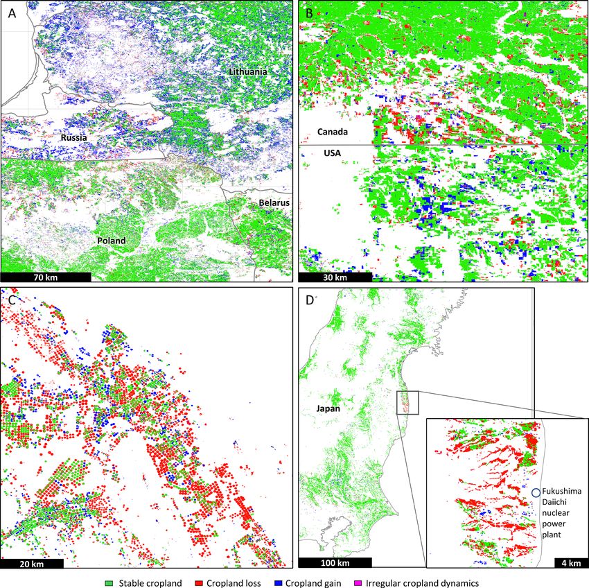
Extended Data Fig. 6 | Regional-to-local scale examples of cropland dynamics, 2000–2019. Regional-to-local scale examples of cropland dynamics,
2000–2019. a – Cross-boundary cropland dynamics in Eastern Europe (center at 22.48°, 54.35°); b – Cropland dynamics on the border between
Saskatchewan, Canada, and Montana, the USA (center at −106.08°, 48.99°); c – Decline of irrigated cropland area, Saudi Arabia (center at 43.58°,
27.14°); d – Cropland abandonment after 2011 nuclear disaster on Fukushima Daiichi nuclear power plant, Japan (zoom-in image center at 141.03°, 37.42°).
Country boundaries are from GADM (https://gadm.org).
Nature Food | www.nature.com/natfoodNature Food Articles Extended Data Fig. 7 | National total and per capita cropland area change from 2003 to 2019. National total and per capita cropland area change from 2003 to 2019. Countries with change below 20% are shown in gray and not labeled. Only countries with 2019 cropland area above 1 Mha were analyzed. DRC stands for the Democratic Republic of the Congo. Nature Food | www.nature.com/natfood
You can also read