Guide to New South Wales
          Karst and Caves
←
→
Page content transcription
If your browser does not render page correctly, please read the page content below
Guide to New South Wales
Karst and Caves
Karst and cave locations

                           National parks
                           & reserves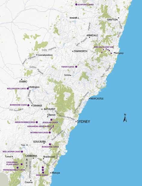
Contents

  Overview                                 2

  Abercrombie Karst Conservation Reserve   8

  Ashford Caves                            10

  Borenore Karst Conservation Reserve      12

  Bungonia State Conservation Area         14

  Cooleman Plain Karst                     16

  Deua Karst                               18

  Jenolan Karst Conservation Reserve       20

  Kanangra-Boyd Karst                      22

  Macleay Karst Arc                        24

  Timor Caves                              26

  Wee Jasper Caves                         28

  Wellington Caves Reserve                 30

  Wombeyan Karst Conservation Reserve      32

  Yarrangobilly Caves                      34

  Other areas                              36

  Further information                      38
Overview

     New South Wales boasts a wide diversity of rock types ranging in age from over 2.5 billion years to those
     currently forming along our coastlines. These many different rocks are represented in a range of geological
     structures, including major faulting and folding zones, extinct volcanoes, ancient glacial formations and,
     importantly, karst and caves.
     These landforms, features and processes – our geodiversity – are the backbone of many NSW national parks
     and form the outstanding scenic elements of areas such as the Blue Mountains, the Warrumbungles and
     other northern NSW volcanic sites, the Great Eastern Escarpment, the glaciated areas of Kosciuszko
     National Park, and the coral reefs around Lord Howe Island.

     Value of karst
     A significant and often undervalued element of geodiversity is karst, a term which describes the suite of
     landforms produced by the action of natural waters on soluble rocks, most commonly, limestone and
     dolomite.
     Karst landforms include caves and their contents, gorges, closed depressions and minor surface features,
     reflecting the often complex relationships between surface waters and groundwaters. These landforms are
     part of the rich geodiversity upon which we live and are highly regarded for their natural, cultural,
     scientific, recreational, socio-economic and aesthetic values.
     Karst landforms act as important refuges for plants and below-ground organisms; some karst caves are
     capable of preserving bones extremely well with sites like Wellington producing fossils of national and
     international significance.
     Like other Southern Hemisphere continents, there are limited areas in Australia able to host the
     development of karst and caves. NSW, with over one hundred areas of limestone and other carbonate rocks
     spread across the state, has a major role to play in conserving Australia’s scarce karst heritage.
     Karsts are truly ‘living landscapes’ as they are the outcome of the complex interplay over time of climate,
     topography, soils, hydrology and biology. These developmental processes are enhanced by the

     Devils Coach House, Jenolan Caves. Photo: S. Babka

2
acidification of water by atmospheric carbon dioxide and, even more importantly, from elevated carbon
dioxide levels in the soil as a result of root and animal respiration, the decay of organic matter and other
sources.

Role of topography
The presence, scale, type and complexity of karsts are
influenced by topography. In NSW the dominant topographic
feature is the Eastern Australian Highlands (the ‘Great Dividing
Range’), a series of plateaus that extend virtually uninterrupted
for the entire length of the eastern seaboard. The state’s seven
topographic zones are commonly recognised as:
Coastal Plain – This narrow plain extends from the Tasman Sea
to the foot of the Eastern Escarpment and grades into the
escarpment through increasingly hilly terrain. The only major
karst in this zone is inland from Kempsey at Yessabah with a
minor area at sea level at Myall Lakes.
Eastern Escarpment – This zone marks the rapid change in
topography between the coastal plain and the mountain
ranges, tablelands and dissected plateaus of the Great Dividing
Range. Karsts at Deua National Park, Bungonia State
Conservation Area, the Jenolan and Wombeyan karst
conservation reserves, Colong, Timor, Stockyard Creek and
others near Kempsey and Wombeyan, have formed in, or
beside, deep valleys cut into the escarpment.                          Broken Column, Lucas Cave. Photo: courtesy JCRT

Highland Plateaus – This broad series of plateaus range in elevation
from 800 to 1300 metres and form the crest of the Great Dividing Range. Karsts located on the Highland
Plateaus include Rosebrook and Kybean.
Western Slopes – These are the western flank of the Highland Plateaus, containing important karsts such
as Cliefden, Wellington and Borenore.
Western Plains – This extensive area of low-lying land incorporating the Murray and Darling Riverine plains
contains little or no karst development.
Western Uplands – Carbonate rocks have been reported in this
zone in the area north of Broken Hill, but no integrated karst
systems or caves are known. Small-scale solution features
(karren) have been found at a number of sites including Mount
Arrowsmith, while there are probable ‘fossil’ karst features north
of Broken Hill at Torrowangee.
Western Incised Zone – On the western side of the highlands,
this zone includes karsts such as Abercrombie, Wee Jasper,
Cooleman and Yarrangobilly, which are situated in the steep,
upper tracts of westward-flowing streams. The last two karsts
occur at relatively high elevations where they currently
experience sub-alpine conditions and, previously, alpine
conditions in the last Ice Age.

                                                                       Brush-tailed rock wallaby. Photo: courtesy JCRT

                                                                                                                  Overview   3
Bath of Venus, Pool of Cerberus Cave, Jenolan Caves. Photo: courtesy JCRT

4         Guide to New South Wales Karst and Caves
The management and maintenance of karsts requires attention to overlying soils and vegetation as well as
hydrologic regimes. It also depends on a sound understanding of topographic influences and the adoption
of a whole-of-catchment approach, which identifies and
manages the impacts of human activity on a broader scale.

NSW karst and caves
One of the more obvious and commonly recognised karst
landforms are caves or features that are large enough for
humans to enter and explore using some form of lighting. The
vast majority of these caves are only a few metres in length.
However, the interconnections between them may be
microscopic suggesting that most, or all, of the caves within a
particular karst environment are interlinked (or at least have
been in the past).
In NSW there are more than 2000 caves in approximately one
hundred karst environments. These include show or developed
caves at Abercrombie, Jenolan, Wee Jasper, Wellington,
Wombeyan and Yarrangobilly, which provide enhanced
opportunities for visitors to appreciate this important element of
the state’s geodiversity. Show caves are also important from a
socio-economic perspective, generating income for regional
communities and providing employment opportunities.
Cave exploration is a pastime enjoyed by many, including
organised speleological clubs who have contributed significantly     Casteret Cave. Photo: courtesy JCRT
to our understanding and appreciation of these special
environments. Therefore, caves and karst environments generally can be looked upon as an important
educational resource and a ‘textbook’ for explaining the Earth’s development. Some caves may also be
associated with the Dreamtime stories important to local Aboriginal people.
In a biotic sense, caves are important in providing habitat for a variety of highly evolved plants and animals.
These include what are often referred to as ‘living fossils’: cave-adapted invertebrate species, which closely
resemble their ancient ancestors and in many cases have no eyes or pigmentation. Cave-dependent animals
can provide critical clues in understanding the evolution of life, while the bats that live and breed in caves in
their tens of thousands are useful in controlling insect pests.
Other karst landforms in NSW may be less spectacular than its
caves, but features such as the limestone gorges at Yarrangobilly,
Cooleman, Bungonia and Marble Arch are also well worth a visit.
Similarly, small-scale limestone sculptures, called karren, are
found almost everywhere on limestone and are often very
beautiful.
In addition to its karst caves, the state also hosts some fine
examples of karst-like features such as the impressive Big Hole
south of Braidwood (30 metres across and 100 m deep), the
Hilltop Natural Tunnel and the beehive-like domes of Monolith
Valley in Budawang National Park. These features all formed in
rocks other than limestone. There are also hundreds of sea caves
along our rocky coasts.
                                                                         Cave research. Photo: courtesy JCRT

                                                                                                               Overview   5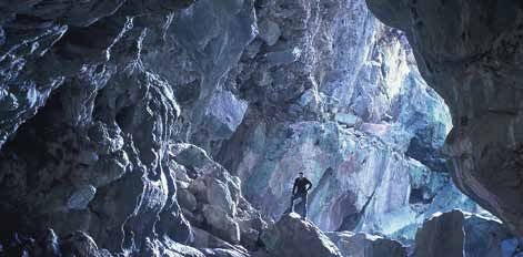
Compared with many other countries, Australia has a relatively limited range of karst and cave resources,
    with NSW having a large proportion of the nation’s more important sites. These include:
    •   the world-class show caves of the Jenolan Karst Conservation Reserve (within the Greater Blue
        Mountains World Heritage Area), which is said to have the oldest known caves open to the surface
    •   the mammalian fossils from Wellington Caves, which are important for their contribution to
        palaeontology as a science and thought by many to have influenced Charles Darwin’s thinking on the
        origin of species and his Theory of Evolution.
    In addition to these notable mentions, the caves at Wellington, Yarrangobilly, Wee Jasper and Wombeyan
    karst conservation reserves are of national significance from geological, biological and palaeontological
    perspectives. Other potential candidates for listing in this category include Cooleman Caves and the
    Macleay Limestone Belt, which are both highly regarded for their significant biotic and abiotic values. Many
    other karst environments throughout NSW are also important for their cave-dependent fauna, their
    contribution to the understanding of landscape evolution, and their past and current meaning to
    Aboriginal and non-Aboriginal people.

    Caring for karst
    Fortunately, almost all of the state’s significant cavernous karst environments are within national parks and
    nature reserves, which are under the care of the Department of Environment, Climate Change and Water or
    administered by the Department of Lands. Most have their entire catchments within formally protected
    areas which allows for proper management of the water, soil and vegetation that are essential for the
    health of karst ecosystems. Other areas, largely on private lands, may be less well protected, meaning that
    those areas under public management are best placed for future generations to use and enjoy.
    It is also important to note that limestone is a mineral used daily for a variety of purposes. However,
    exploiting it must always be balanced against the other benefits provided by karst limestones, such as the
    maintenance of groundwater quality and quantity, spiritual and emotional well-being and an enhanced
    understanding of climate change and the rates and modes of evolutionary processes.

    Victoria Arch stream passage, Wombeyan Caves. Photo: G.K.Smith

6   Guide to New South Wales Karst and Caves
Responsible caving
Caving is an activity that involves inherent risks. Cave environments may contain areas of
little or no natural light, uneven and slippery surfaces, unstable areas, cold water, deep
pools, foul air from elevated carbon dioxide levels, sudden and unfenced drops, and other
natural hazards.
In some cases, the risks associated with caving can be reduced to more acceptable levels
but they can never be completely eliminated. So it is important to be aware at all times and
consider the following suggested steps to minimise risks:

•   When caving, adopt an attitude of self-reliance, responsibility and preparedness. In
    practical terms this means careful planning, competent organisation, appropriate
    provisioning and thorough training.
•   Undertake caving in parties of at least four. This is generally considered to be the
    smallest sized group that is able to muster sufficient physical resources for effective
    self-rescue and provide adequate care should a member become injured or
    incapacitated.
•   Ensure at least one member of the party holds an approved first aid certificate and that
    all participants know basic emergency procedures in case of an accident.
•   Before every trip:
    determine the known and potential hazards that exist in the caves to be visited
    decide on the communication procedures that will be used while underground
    ensure all participants have the necessary qualifications, competencies and experience
    needed to undertake the proposed activities and safely navigate and manage the
    conditions and hazards that can reasonably be expected.
For more tips and information on staying safe in national parks, visit the park safety
webpage at www.environment.nsw.gov.au/parksafety/

Always remember to check with the local Parks and Wildlife office or visitors centre listed in
this guide about the conditions and requirements for accessing caves.

The responsible caving message above incorporates elements of the Australian Speleological
Federation Inc. Cave Safety Guidelines (1999).

                                                                                                 Overview   7
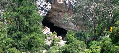
Abercrombie
    Karst Conservation Reserve

      Location
      Located in the Central Tablelands of NSW, Abercrombie Karst Conservation Reserve lies approximately 80
      kilometres south-west of Bathurst and 129 km north-west of Goulburn. The reserve is 1434 hectares in size
      and forms part of the Bathurst Local Government Area.

      History
      Archaeological evidence suggests that Aboriginal people (including the Wirradjuri and Gundungurra
      groups) frequented Abercrombie Caves and surrounding areas some 2000 years ago. While the extent and
      nature of this use is largely unknown, it is likely the caves were at some point used for refuge and the
      surrounding areas as a source of food and water.
      From a European perspective the reserve has a rich history. This is thought to have commenced in the early
      1820s when locals referred to the area as ‘The Bridge’, a reference to the large natural arch spanning Grove Creek.
      In 1830 this association became more pronounced when a group of escaped convicts, known as the ‘Ribbon
      Gang’ and led by Ralph Entwistle, robbed homesteads and terrorised the district, using the caves as hideouts.
      Tourism was first recorded in the area in 1834 when the owner of ‘Bald Ridges’, a nearby property, escorted
      visitors through Abercrombie Caves. However, they were not officially ‘discovered’ until 1842 by then NSW
      Surveyor General Walker Davidson.
      A slightly later discovery in the region was gold in 1851, leading to an influx of miners who, on learning of
      the reserve’s caves, constructed a small dance platform in the Archway around 1860. A bigger dance
      platform, built in 1880, can still be seen in the Archway today. Miners were also responsible for coining the
      name Abercrombie Caves, which until then had been referred to by several names including, as previously
      mentioned, ‘The Bridge’, along with ‘Grove Creek Caves’ and ‘Burragylong Caverns’.
      Over time, many of the caves’ delicate formations were damaged by the activities of miners, leading to the
      appointment of Samuel Grosvenor as the site’s first official caretaker in 1889.
      Access issues and floods limited early visitation to the reserve and, following the largest known flood in
      April 1950, the caves were closed for two years while high-level suspension bridges were constructed. On
      re-opening, the caves were shown for the first time using electric lights.
      Today the reserve continues to attract large numbers of visitors each year with its caves regularly used for
      concerts and weddings.

      Goldminers’ dance platform in the Hall of Terpsichore. Photo: courtesy JCRT

8     Guide to New South Wales Karst and Caves
Geology and geomorphology
Abercrombie Karst Conservation Reserve’s caves have developed in a regionally metamorphosed
limestone (marble) that locally forms part of the Upper Silurian Kildrummie Formation and, on a broader
scale, the Hill End Synclinorial Zone. Metamorphism in the caves has been considerably more intense than
at other major NSW karst areas, resulting in extensive re-crystallisation of the limestone.
Abercrombie Caves contains an abundance of features formed by erosion or weathering (speleogens), as
well as an excellent example of a cut-off subterranean meander. The caves also feature significant
vertebrate deposits, including the skeletal remains of marsupial megafauna.
Limestone at the reserve is underlain by layers of basic volcanics and shales and overlain by a series of
sandstones, shales and greywackes. Following deposition of these sediments, the region surrounding the
reserve was intensely folded and eroded.
The reserve’s karst is impounded with its body of limestone entirely surrounded by impervious rocks.
Despite this, it contains a well-developed karst system in a relatively restricted area of limestone. The main
feature is the Grand Arch, a through-cave approximately 200 metres long, an average 40 m wide and with a
maximum height of 32 m.
Ecology
Abercrombie Karst Conservation Reserve contains a significant area of intact remnant vegetation in a
region which has been extensively cleared. Within this are several
species of rare or threatened flora, notably Bossiaea fragrans, a
shrub recently classified as critically endangered and known only
to occur in the reserve.
The reserve is inhabited by a diverse range of fauna. Above
ground, this includes the vulnerable peregrine falcon (Falco
peregrinus) and the regionally uncommon sugar glider (Petaurus
breviceps). Below ground, its caves provide roosting and
maternity sites for a number of bat species: the vulnerable
eastern bent-wing bat (Miniopteris shriebersii oceanensis), as well
as the eastern horseshoe bat (Rhinolophus megaphyllus) and little
mastiff bat (Mormopterus planiceps).
Many cave-adapted invertebrate species have been recorded at
the reserve including at least eight species of spiders. Among Abercrombie Archway. Photo: courtesy JCRT
these is the cave shawl spider (Badumna socialis), which is known
only to occur in the large arches of the Abercrombie and Jenolan
cave systems.
Access and services
Access to Abercrombie Karst Conservation Reserve is by Trunkey
Creek–Goulburn Road, which is unsealed in sections from Crookwell.
The reserve provides excellent opportunities for guided and self-
guided cave tours, bushwalking, fishing, swimming and fossicking.
A kiosk is open daily and offers light refreshments. Camping and
cabin accommodation is also available, and there are amenities
blocks with hot showers, toilets and a laundry on-site.
Speleothems in Archway Cave. Photo: A.Baker
Abercrombie Karst Conservation Reserve 9Ashford Caves
Location
Ashford Caves lies within Kwiambal National Park, which is located in the North West Slopes and Plains of
NSW approximately 220 kilometres north of Armidale and 90 km north of Inverell. The 1301-hectare park
forms part of the Armidale Dumaresq Local Government Area.
History
Ashford Caves is within the traditional area of the Kwiambal People (pronounced Kigh-am-bal), who used its
abundance of water, food and materials for year-round living and subsistence. Tragically, many of the
indigenous group were killed by gangs of armed ex-convicts, who worked in the area following the arrival of
Europeans in 1830.
It is likely that Europeans became aware of the area’s caves shortly after their arrival. From 1916 to 1967, at least
three caves were sporadically mined for their phosphate-rich bat droppings (guano), which was used as a
fertiliser. The current entry to Ashford Main Cave is the result of excavation of 1-2 metres of guano from the
cave floor and tunnelling through bedrock.
In 1915, land encompassing most of the caves in the area was declared a Recreation Reserve and ever since
this has been a popular destination for visitors. Kwiambal National Park was dedicated in April 2000 following
the purchase of local property leases by the NSW Government. Several adjoining Crown reserves, including
Ashford Caves, were also incorporated into the new park.
Geology and geomorphology
Ashford Caves occurs on the northern edge of a limestone outcrop, which stretches for 10 kilometres along
Limestone Creek. The area’s limestone is Carboniferous in age (about 330 million years old) and was
metamorphosed into marble by the heat and pressure generated when nearby volcanic and igneous rocks
formed.
Ashford Main Cave has approximately 560 metres of horizontal passage, with two main entrances and a
number of smaller openings. However, while relatively large in size, the cave only has a limited number of
intact decorations because of past mining activity and dissolution by guano and bat urine.
Eastern horseshoe bat. Photo: G.K.Smith
10 Guide to New South Wales Karst and CavesFour types of fossil bone-rich sediments have been discovered in Ashford Caves. While the age of these
sediments is unknown, they are considered palaeontologically significant as they lie between the Late
Tertiary deposits of the Darling Downs and Riversleigh areas in Queensland (15 to 1.8 million years in age) and
the 30,000-year-old Quaternary deposits found at Wellington in NSW. The sediments are also thought to have
the high potential to provide valuable information on past environmental conditions and the make-up of
local fauna, although to date their use for these purposes has generally been limited.
While locally significant, the limestone caves of Kwiambal National Park are to some degree overshadowed by
the Macintyre and Severn rivers. These rivers are framed by spectacular, steep-sided gorges in their lower
sections, and contain numerous waterfalls such as the popular Macintyre and Severn River falls. Surrounding
and complementing these features is a landscape dominated by huge granite boulders and rugged hills.
Ecology
Ashford Caves provides important habitat for a variety of cave fauna, including a viable population of the
eastern bent-wing bat (Miniopterus schreibersii oceanensis), which is listed as vulnerable under the Threatened
Species Conservation Act 1995, and the eastern horseshoe bat (Rhinolophus megaphyllus).
Thousands of these bat species migrate to Ashford Main Cave over the summer months to give birth and raise
young. Visitor access to the cave is restricted over this period as disturbance of maternity colonies can result in
the abandonment and mortality of infant bats.
Sixteen species of invertebrate fauna have been recorded in Ashford Caves, including a new endemic species
of beetle (Speotarus princes), which had never been previously
recorded in caves. Prior to disturbance from guano mining and
public visitation, it is also likely that the caves have provided
habitat for many other invertebrate species.
On a broader scale, Kwiambal National Park is one of the largest
areas of remnant woodlands on the intensively farmed and cleared
north-western slopes of NSW. Common tree species include the
white cypress pine (Callitrus glaucophylla) and silver-leaved
ironbark (Eucalyptus melanophloia). The park also includes
approximately 200 hectares of rare dry rainforest.
The flora communities of the park, together with its rivers, rocky
outcrops and cliff overhangs, provide habitat for a diverse range of
native fauna, including 101 birds, 32 reptiles, 11 frogs and 30
Ashford Main Cave. Photo: G.K.Smith
mammals.
Access and services
To reach Ashford Caves, follow the signs from Ashford Village for
approximately 28 kilometres. From this point access to other parts
of Kwiambal National Park is via sealed and unsealed road.
The area immediately surrounding Ashford Caves contains picnic
tables and public toilets. Ashford Main Cave is horizontal, allowing
easy access for visitors outside of the summer bat maternity
season.
Kwiambal National Park offers spectacular waterfalls, walks and
camping areas and provides excellent opportunities for swimming
and fishing in a number of locations.
Macintyre River, Kwiambal NP. Photo: S.Reilly/DECCW
Ashford Caves 11Borenore
Karst Conservation Reserve
Location
Borenore Karst Conservation Reserve is located in Central NSW, approximately 17 kilometres west of Orange
and 70 km west of Bathurst. The reserve is 136 hectares in size and forms part of the Cabonne Local
Government Area.
History
Borenore Karst Conservation Reserve is within the traditional lands of the Wirradjuri People. While there is
little detailed knowledge about their use of the reserve, it contains at least one site known to be highly
significant to local Aboriginal women.
The first recorded European visitor to the reserve was John Henderson in 1830 who inspected its caves and
associated features during geological reconnaissance work in the region. The next notable visit was by famed
Australian explorer Major Thomas Mitchell in 1836 who visited the reserve’s caves as part of a larger
expedition through NSW.
In 1878, Borenore was declared a Water Reserve and formed part of a travelling stock route. This resulted in
the reserve becoming more widely known, contributing to its current popularity as a local and regional tourist
destination.
In 1898 or thereabouts, Frank Rusconi, a monumental stonemason born in Australia but who learnt his trade
in Italy, recognised the rich quality of the reserve’s marble, which was later acknowledged as some of the
world’s finest and quarried for approximately 30 years. A sample of the famous Borenore ‘red marble’ is on
display at Jenolan Caves House, two hours’ drive away.
Borenore was initially declared a Public Recreation Reserve in 1959. This was repealed in 1997 with the
dedication of Borenore Karst Conservation Reserve under the National Parks and Wildlife Act 1974 in
recognition of the area’s significant karst and cave values.
Geology and geomorphology
Borenore Karst Conservation Reserve’s caves formed from limey muds and coral reefs, which originated from
volcanic islands located on the east coast of Australia about 410 million years ago. Its limestone (and
accompanying rocks) is highly faulted and folded, with lower-lying levels rich in fossils such as crinoids, corals
and trilobites of high scientific value.
Borenore Arch. Photo: S.Woodhall/DECCW
12 Guide to New South Wales Karst and CavesThe reserve’s limestone is overlain by young volcanic basalt rock that formed from lava flows from nearby
Mount Canobolas approximately 10 to 13 million years ago. At this time, or possibly earlier, the heat from
volcanic activity metamorphosed some of the limestone into the high quality marble which was later
quarried. Today the limestone is found as outcrops in a two-kilometre-wide strip that extends in an irregular
pattern for five kilometres along Boree Creek.
The reserve’s karst is listed on the Register of the National Estate for its significant diversity of karst features,
sediments and fossils. Many of these, including caves, a karst bridge and small arch, cliff lines, a blind valley,
dolines (funnel- or saucer-shaped sinkholes in the limestone), springs and small surface solutional features, can
be seen within a short distance of the main visitor picnic area.
The reserve’s ancient caves contain a number of preserved bone-bearing deposits, which have yielded
valuable information on past ecosystems and biota. Arch Cave is the most commonly visited and, even
though many of its features have been damaged over time, intact stalagmites and flowstones can still be
found. The 250-metre-long Tunnel Cave is also popular with visitors and a good example of a stream cave
above a water table containing formations and sediments.
Ecology
Borenore Karst Conservation Reserve is characterised by natural, partially undisturbed, open woodlands
which provide habitat for a diverse range of endemic fauna. It is also important as one of the few remaining
areas of white box (Eucalyptus albens) and yellow box (E. melliodora) grassy woodlands in the region.
Fauna species include the eastern grey kangaroo (Macropus
giganteus), swamp wallaby (Wallabia bicolor), brushtail possum
(Trichosurus vulpecula), ringtail possum (Pseudocheirus peregrinus)
and the vulnerable spotted-tailed quoll (Dasyurus maculatus).
Tunnel Cave is used as a roosting and hibernation site by the
vulnerable eastern bent-wing bat (Miniopterus schreibersii
oceanensis) and is closed to the public over winter.
Over 50 species of birds are attracted to the reserve, including the
uncommon peregrine falcon (Falco peregrinus).
Boree Creek passes through the reserve and has been degraded by
nutrients and soil erosion from over a century of farming within the
catchment. Weed species found in the reserve are managed
through an annual control program.
Karren feature. Photo: G.K.Smith
Access and services
Access to Borenore Karst Conservation Reserve is by Orange–
Forbes Road, which is sealed. The access road to the picnic area is
an all-weather gravel road.
The reserve contains picnic facilities, including tables and gas
barbecues, and public toilets. Well-maintained walking tracks
traverse the area, providing an opportunity for visitors to explore
Arch Cave, a variety of protruding limestone outcrops and the
remnant stand of threatened white box–yellow box woodland.
Camping is not permitted at the reserve which closes at 7 pm daily.
Speleothems. Photo: R.Commins/DECCW
Borenore Karst Conservation Reserve 13Bungonia
State Conservation Area
Location
Bungonia State Conservation Area is located in the Southern Tablelands of NSW, approximately 180
kilometres south-west of Sydney and 35 km east of Goulburn. The 3977-hectare reserve forms part of the
Goulburn Mulwaree Local Government Area.
History
Bungonia lies within the traditional lands of the Njunawal People, adjacent to the north-western corner of
the Wandandian Tribal Territory and the southern boundary of the Gandangara Tribal Territory. Little is
known of the area’s traditional significance, although the remains of historic campsites indicate it was used
in the past for tool manufacturing. The presence of bone deposits also suggests the use of at least one of
the caves as a burial site.
The first recorded European discovery and exploration of a cave at Bungonia (probably the entrance to
Drum Cave) was by botanist Alan Cunningham in April 1824. Soon after, the caves became popular with
recreational groups and this, combined with their relative proximity to major centres, led to the declaration
of the Bungonia Caves Reserve in 1872.
In 1889, local property owner and unofficial tour guide Louis Guymer was appointed the first and only
caretaker of Bungonia, a position he held until 1909. Guymer is credited with discovering many of
Bungonia’s caves and was also responsible for much of their early development.
The formation of numerous caving clubs in the 1950s led to more extensive exploration of Bungonia’s
caves. This period also saw an increase in visitation mainly due to the development of more advanced
abseiling equipment, which allowed greater access to the caves. Today, Bungonia is one of the most
popular recreational caving areas in NSW with over 15,000 people making the trip each year.
Geology and geomorphology
Bungonia is regionally placed on the Lachlan Fold Belt adjacent to the south-western edge of the Sydney
Basin. Its caves have developed in the Bungonia Group, which consists of shallow marine sediments
containing three limestone units plus volcanic rock, sandstone, siltstone and shale.
Deposition of the Bungonia Group was highly complex. In the Late Silurian and Early Devonian periods, marine
sediments that would eventually form the Lookdown Limestone were laid down in the eastern margin of the
Bungonia Gorge. Photo: M.Van Ewijk/DECCW
14 Guide to New South Wales Karst and CavesWollondilly Basin. This was followed by influxes of sediment (the Cardinal Shale) which hindered reef
development until favourable conditions allowed carbonate-producing organisms to deposit what is now the
Folly Point Limestone.
Following this period of development, limestone deposition was further interrupted by influxes of fine
mud (efflux siltstone), before marine organisms re-flourished to produce the sediments of the Sawtooth
Ridge Limestone.
Subsequent volcanic activity covered this marine life with sediment (the Tangerang Formation) before the
sequences were folded to almost vertical.
The most conspicuous and striking local feature is the slot canyon
on Bungonia Creek, which at nearly 300 metres deep is one of
the best examples of a limestone gorge in Australia. Bungonia
also contains numerous below-ground features of state and
national significance, including its caves which are some of the
deepest on mainland Australia.
Compared with many other areas, the caves at Bungonia contain
relatively few decorated speleothems, the cave formations formed
by the deposition of minerals, mainly calcite. However they do
boast a diverse range of bedrock fossil deposits, yielding several
new species.
Ecology Abseiling. Photo: R.Commins
The geology and landforms at Bungonia provide for a wide range
of flora and communities, including several rare and threatened species such as the orchid (Pterostylis
calceolus) and shrub (Pimelea axiflora subsp. pubescens), both of which have not been recorded elsewhere.
Bungonia is habitat for a wide variety of fauna, including kangaroos, wombats, possums, gliders and a
population of koalas found in the southern part of the reserve, along with evidence of the continued
existence of the vulnerable spotted quoll (Dasyurus maculatus).
Bungonia is home to a regionally significant population of the vulnerable eastern bent-wing bat
(Miniopteris shreibersii oceanensis) and the eastern horseshoe bat (Rhinolophus megaphyllus), both of which
use Drum, Grill, Chalk and other caves for roosting and maternity purposes. In addition, more than 50
invertebrate species inhabit Bungonia’s caves including NSW’s only known cave-dependent silverfish
(Trinemura anemone), and a rare beetle (Notospeophonus jasperensis vicinus) and pseudo-scorpion
(Paraliochthonius cavicolus).
Access and services
Access to Bungonia State Conservation Area is by Lookdown
Road via the town of Bungonia, 25 km east of Goulburn.
Bungonia is one of the state’s most popular areas for recreational
caving (which operates via self-registration or permit).
Bushwalking, canyoning and rock climbing are also popular
activities which require self-registration.
Bungonia has three lookouts – two of them accessible by
wheelchair – as well as picnic facilities and a camping ground.
Rock pool in gorge. Photo: DECCW
Bungonia State Conservation Area 15Cooleman Plain Karst
Location
Cooleman Plain is located on the north-eastern boundary of Kosciuszko National Park, approximately 77
kilometres from Canberra and 88 km from Tumut. The karst at Cooleman Plain is between 1700 and 2000
hectares in size and forms part of the Tumut Local Government Area.
History
Aboriginal people, including the Bidewal, Ngunnawal, Walgalu and Wiradjuri, have inhabited and shared the
resources of the Snowy Mountains high plains for at least the last 20,000 years. The Walgalu people are the
traditional custodians of much of the area surrounding Kiandra and Long Plain, which once formed part of a
major travel route through the mountains to the coast. Archaeological records also indicate that local Aboriginal
people used the limestone cliffs and caves in many parts of the Snowy Mountains for shelter and burial places.
By the early 19th century, the arrival of European settlers and subsequent spread of disease caused the
fragmentation and decline of local Aboriginal clans. However important strands of their culture, including
their sense of identity and association with the local landscape, remain intact today.
By 1850, pastoralists of European origin were grazing thousands of stock on Cooleman Plain. A restored
homestead complex on the road to Cooleman Plain Karst is a magnificent relic of past grazing in the area.
In 1944, the Kosciuszko area (incorporating much of Cooleman Plain) was declared a State Park. This was
extended to National Park in 1969, which saw the phasing out of cattle grazing and other activities
considered to be damaging the park and greater recognition of the area’s natural beauty.
Geology and geomorphology
The limestone at Cooleman Plain formed approximately 420 million years ago, when it was thought to have
collapsed into a marine caldera, the huge depression left by an explosive volcanic eruption. The large circular
outcrop of limestone surrounded by mainly volcanic rock that remains today is evidence of this event.
Cave and karst features developed on the limestone following its uplift above sea level around 400 million
years ago, before it was once again covered by the ocean and a layer of sedimentary rock.
Upon lifting above sea level a second time, it took many millions of years of erosion to remove the
sedimentary rocks overlying the limestone, re-exposing it some 65 million years ago. Since this time, most of
Nicole Gorge, Cooleman Plain, Kosciuszko National Park. Photo: A.Baker/DECCW
16 Guide to New South Wales Karst and Cavesthe caves and features evident today have developed, although
some landform elements associated with the first land-forming
phase 400 million years ago can also be discerned.
Cooleman Plain Karst contains an outstanding collection of
features, including dry valleys, springs, stream sinks and more
than one hundred caves. It is commonly regarded as one of the
most beautiful karst areas in NSW and can be viewed from
walking tracks winding through limestone gorges and over ridge
tops, revealing striking rock formations, open limestone plains,
springs, rivers, waterfalls and caves.
Four of the main caves – Murrays, Barbers and the left and right
Cooleman Caves – are predominantly horizontal and can be
explored by torchlight. Though heavily souvenired in the 19th Brachiopod shell fossils. Photo: A.Baker/DECCW
and 20th centuries, these and other caves at Cooleman Plain
contain a wide range of cave formations formed by the deposition of minerals, mainly calcite (speleothems)
and excellent examples of marine fossils, visible in many of the cave’s bedrock walls.
Ecology
Landscapes of Cooleman Plain Karst range from broad grassy plains pockmarked with sinkholes and
rimmed by timbered hills to dramatic limestone gorges and waterfalls.
The plains of Cooleman Karst are dominated by tussock grass with occasional patches of woody shrubs.
Rising from the plains, its broad valleys drain cold air, creating frost hollows where winter temperatures
drop to a point where trees are unable to survive. On the edges of the plains, woodlands presided over by
snow gums (Eucalyptus pauciflora) are common, while the area’s higher country is more heavily timbered
with species such as the manna gum (E. viminalis), narrow-leaved peppermint (E. radiata) and alpine ash (E.
delegatensis). In some areas of the plains the weeping gum (E. lacrimans) can also be found.
Cooleman Plain Karst provides habitat for a variety of fauna, including platypus, water rats and possums. Its
caves, in particular, support a rich diversity of cave-adapted invertebrates and a roosting site for the
vulnerable eastern bent-wing bat (Miniopterus schreibersii
oceanensis), one of only two such sites in Kosciuszko National
Park.
Feral horses are common to the area and are causing erosion and
damage to micro-solutional features on exposed limestone
surfaces. A program to remove the horses is currently in place.
Access and services
Access to Cooleman Plain Karst is by Long Plain Road via the
Snowy Mountains Highway. For safety reasons, Long Plain Road is
unsealed and closed between the June and October long
weekends. This period may be brought forward or extended due
to weather conditions.
Two camping grounds and a car park are located near Blue
Waterholes, the starting point for exploration of the area’s gorges
and caves. Fishing, bushwalking and bike riding are also popular
activities.
Clarke Gorge. Photo: A.Baker/DECCW
Cooleman Plain Karst 17Deua Karst
Location
A number of karst environments occur in Deua National Park, which is located in southern NSW near the
townships of Braidwood, Moruya and Cooma. The park is 122,000 hectares in size and straddles the
Eurobodalla and Palerang local government areas.
History
The Yuin People (including a number of tribal groups) are the traditional custodians of the park and have a
long association with its karst environments. Creation stories told by the Walbanga Tribe speak of the
formation of the caves, while it is widely believed that local Aboriginal people used the spring waters
emerging from Bendethera and Wyanbene caves for healing purposes.
European association with the park commenced around 1860 when Bendethera Valley was leased for
pastoral purposes by Joseph George. Public awareness increased in 1880 following the discovery of
Bendethera Cave by George’s son Benjamin, leading to part of the valley being declared a Public Recreation
Reserve in 1896.
In the north-west of the park, a cave within the Wyanbene Limestone is thought to have been used as a refuge
for the Clarke brothers, bushrangers who frequented the area before eventually being captured in 1867.
Wyanbene Cave, the best-known limestone feature of the north-western area of the park, is reported to have
been used for public displays during the early 1930s, most likely in conjunction with visits to nearby Big Hole.
Wyanbene continues to be popular with both visitors to the area and members of the local community.
Geology and geomorphology
Deua National Park consists of some of the most isolated and rugged mountain ranges in south-eastern
NSW. It also contains significant limestone deposits, which formed in the Late Silurian period,
approximately 420 million years ago.
Subsequent geological periods have seen the creation of a diverse and complex geology. During a period of
volcanism and folding, large granite bodies formed under the Silurian rocks in the north of the park,
metamorphosing much of the area’s limestone into coarse red and white marble. In the park’s south, faulting
tore apart the limestone at Bendethera, leaving three exposed outcrops approximately 500 metres apart.
Aragonite anthrodites, Wyanbene Cave. Photo: A.Baker
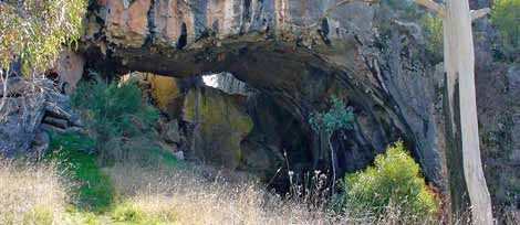
18 Guide to New South Wales Karst and CavesIn the north-west of the park, a small canyon and natural arch (Marble Arch) have formed in the limestone.
Nearby, and equally impressive, is Big Hole, a vertical shaft approximately 114 metres deep and 30–50 m in
diameter. Situated in sandstone and conglomerate, this spectacular feature is believed to have formed
when surface rock collapsed progressively into a cavity formed within the limestone or mineralised rocks.
Other karst features of interest include Bendethera Main Cave, which consists of large bell-shaped
chambers rising high in the mountains and giant flowstone formations stained by bat droppings. Also
significant is the kilometre-long River Cave (part of the Wyanbene Cave system), which contains extensive
formations, including large masses of flowstone and unusual helictites, twig-like lateral projections of
calcite that take the appearance of curving quills.
Ecology
The rugged and more isolated areas of the park contain animal communities which have been largely
undisturbed by Europeans. These include some of the area’s larger marsupial species such as the swamp
wallaby (Wallabia bicolour), echidna (Tachyglossus aculeatus), greater glider (Petauroides volans) and the
threatened brush-tailed rock wallaby (Petrogale penicillata).
Over 106 species of birds have been recorded in the park, including the sooty owl (Tyto tenebricosa), which
often roosts and nests in the area’s limestone cliffs and overhangs and is listed as vulnerable under the
Threatened Species Conservation Act 1995.
The park’s caves contain cave-dependent invertebrate populations of regional and state significance along
with colonies of eastern bent-wing (Miniopterus schreibersii
oceanensis) and eastern horseshoe (Rhinolophus megaphyllus)
bats, which typically use the darker regions of the caves for
maternity and roosting purposes.
The rugged, mountainous terrain of the park is covered by Dry
Sclerophyll Forest (Eucalyptus), creating a dense and visually
spectacular landscape. In the coastal areas of the park,
heathlands with freshwater wetlands associated with the Deua
and Shoalhaven river systems are common.
The limestone outcrops at Bendethera are dominated by a single
species of wattle, Acacia covenyi, commonly known as
Bendethera wattle or blue bush. This species is endemic to the
Bendethera limestone and has adapted to the soils, climate and
The Big Hole. Photo: A.Baker
general environmental conditions peculiar to this geological unit.
Access and services
Access to the Big Hole, Marble Arch and Wyanbene Cave is via
linked walking tracks, which commence at the head of the
Berlang and Wyanbene tracks.
A four-wheel drive vehicle is required to reach Bendethera Valley.
It is advisable to check on the condition of access roads prior to
visiting in winter and wet periods. On reaching the valley floor, a
walking track provides access to Bendethera Main Cave.
A permit is required to access all caves in the park, with the
exception of Bendethera Main Cave, the first 200 m of Wyanbene
Cave and the karst features of Big Hole and Marble Arch. Wyanbene stream passage. Photo: Olaf Theden/National
University Caving Club
Deua Karst 19Jenolan
Karst Conservation Reserve
Location
Jenolan Karst Conservation Reserve is located on the western spur of the Blue Mountains, approximately
180 kilometres west of Sydney and 30 km south-east of Oberon. The reserve is 2422 hectares in size and
forms part of the Oberon Local Government Area.
History
The Gundungurra and Wiradjuri Peoples have a long association with the reserve and its surrounding lands
as evident by the numerous stone artefacts found in its valleys, ridge lines and limestone overhangs.
European history is thought to have commenced in 1838 when runaway convict James McKeown used the
isolated Jenolan Valley and two of its caves as hideouts for approximately three years. James Whalan, a
local pastoralist, captured McKeown in 1841 and was the first to report the presence of caves in the area.
Initially only a small number of people made the arduous trip to the area’s caves. However, by 1864 the
souveniring of cave decorations had become so commonplace that local Member of Parliament John Lucas
sought their formal protection. This led to the area being declared a ‘Reserve for the protection of caves
and leisure’.
Between 1890 and 1927, the culturally significant and visually imposing Jenolan Caves House was constructed
along with such visitor facilities as cave pathways and lighting. In 1997, the area was declared a Karst
Conservation Reserve confirming its continuing status as one of the state’s premier visitor destinations.
Geology and geomorphology
Since its formation 420 million years ago, the limestone at Jenolan has been shaped by multiple periods of
folding, marine inundation, uplift, erosion and cave-forming processes. The once horizontal bed of
limestone was turned on its edge and now outcrops on the surface as a 260-metre-wide strip that extends
almost continuously over nine kilometres through the centre of the reserve.
The Jenolan limestone is honeycombed with caves, the main system containing over 40 kilometres of
connected passage formed by three creek systems draining through springs at Blue Lake. There is evidence
that some of the caves were formed 350 million years ago, followed by ongoing development of new caves
and modification of older ones up to the present.
Blue Lake across to Grand Arch, Jenolan Caves. Photo: courtesy JCRT
20 Guide to New South Wales Karst and CavesLocated near Blue Lake is a group of three spectacular karst bridges – the Grand Archway, Devils Coach
House and Carlotta Arch – all resulting from ancient river flows eroding and cutting through the limestone.
The developed visitor caves feature some of the most beautiful and exceptional natural decorations in the
world; they are renowned for their range and profusion of secondary mineral cave deposits of calcite
(speleothems), including examples of less common forms such as helictites (flower-like lateral projections of
calcite) and sub-aerial stromatolites (accretions of calcareous algae in the shape of domes and columns).
The caves at Jenolan Karst Conservation Reserve contain a wide range of river sediments and surface soil
infills, which are related to the different environmental conditions that have occurred over millions of years.
Consequently, they can provide valuable information about past climate, vegetation and land formation
processes. Some sediments also contain fossil bone deposits, providing an indication of the type and range
of animal species previously found in the area.
Ecology
Declaration of the reserve in 1866 preceded by other protective actions has meant that most of the area’s
endemic flora and fauna has remained intact, although introduced weed species are noticeable in some areas.
The reserve’s highly dissected mountain terrain supports a mosaic of eucalypt woodland, open forest and
tall shrubland vegetation communities, while its limestone and rock outcrops provide living conditions for
tree species such as the grevillea, bursaria and kurrajong, which have adapted to survive in the area’s
calcium-rich soils. Jenolan Karst Conservation Reserve contains 29 different species of limestone-
dependent mosses and liverworts (bryophytes).
Over 367 species of animals have been recorded in the reserve,
21 of them listed as threatened or vulnerable. These include the
threatened brush-tailed rock wallaby (Petrogale penicillata), sooty
owl (Tyto tenebricosa) and a diverse range of lizards, which use the
precipitous limestone cliffs and cave entrances as havens and for
breeding.
The reserve’s caves contain a rich cave-dependent invertebrate
fauna, including many species that have not been recorded
elsewhere, as well as cave-dwelling bat species of regional and
state significance.
Access and services
Pool of Cerberus, Jenolan Caves. Photo: P.Woodward
Access to Jenolan Karst Conservation Reserve is by Edith Road,
via the town of Oberon, or Jenolan Caves Road, via Hartley. Both
roads are sealed.
The reserve offers a range of guided and self-guided cave tours
and opportunities for adventure caving. It also has many walking
tracks which lead to a variety of natural attractions and historic
buildings.
The visitor precinct at the reserve includes Jenolan Caves House
and a range of other accommodation types. Meals and light
refreshments can be purchased at Caves House and picnic and
barbecue facilities are also available.
Tour group, Imperial Cave circa 1890. Photo: courtesy JCRT
Jenolan Karst Conservation Reserve 21Kanangra-Boyd Karst
Location
A number of karst environments occur in Kanangra–Boyd National Park, which lies within the Greater Blue
Mountains World Heritage Area, approximately 180 kilometres south-west of Sydney. The park is 69,500
hectares in size and forms part of the Oberon Local Government Area.
History
Kanangra–Boyd National Park is within the traditional lands of the Gundungurra (and possibly Wiradjuri)
Aboriginal People, with studies of nearby areas suggesting an Aboriginal prehistory dating back 20,000 years.
The park’s karst environments were first discovered by Europeans in the 1890s. While initially of only minor
prominence, the area grew in popularity following the discovery of Colong and Tuglow caves around the
same time. This new-found fame led to the damage of many of the caves, prompting inspection by Oliver
Trickett, the NSW Government Geologist, whose assessments resulted in the formal protection of Colong,
Church and Billys Creek caves.
In the 1920s, conservationist Myles Dunphy proposed reservation of Kanangra and surrounding areas as National
Park and this, along with other actions, saw much of the area declared a Fauna and Flora Reserve in 1937.
During the 1950s and 60s, mining companies sought to quarry limestone from a number of sites in the
area. In a protracted campaign, the Colong Committee (representing the interests of the Australian
Speleological Federation, National Parks Association and other community groups) successfully lobbied to
halt the proposal.
In 1969, Kanangra–Boyd National Park was created, providing long-term security for some of NSW’s most
outstanding karst and cave locations.
Geology and geomorphology
All of the limestone deposits in the park (and the nearby Wombeyan and Jenolan limestone) formed in the
Silurian Period about 410 million years ago. At this time the Australian landmass was situated close to the
equator and had a coastline fringed by coral reefs and lime-rich mud.
Since their initial formation, the limestones of Kanangra and surrounding areas have experienced
numerous episodes of uplift, folding and faulting. Consequently, many of these now outcrop as north-
south elongated lenses of steeply dipping limestone, set in highly mountainous terrain incised by deep
Rim pools, Tuglow Caves. Photo: A.Baker
22 Guide to New South Wales Karst and Cavescreeks. The area’s limestone lenses have also eroded to form spectacular karst landscapes, which include
several cave systems of importance to science, conservation and recreation including:
• Tuglow Cave, which has an extensive stream cave system containing a large stream and waterfall and is
one of the best examples of this type of cave in NSW
• Colong Cave, which features a large ramified cave system –
6000 metres of highly branched passageway – and a series of
volcanic rock dykes intersecting the cave and controlling its
development
• Billys Creek Caves, which contain numerous cave features and
sandstone fills which contribute to an understanding of
karst-forming processes.
There are numerous other smaller caves in the park. In many
cases these contain outstanding formations or fossil bone
deposits that have accumulated over tens of thousands of years.
It is also likely that the park’s rugged and isolated terrain hides
many other caves of potentially high scientific value.
Colong Cave. Photo: S.Babka
Ecology
The karst environments of Kanangra–Boyd National Park provide living conditions for a variety of fauna
species with many endemic to the area. Examples include the endangered brush-tailed rock wallaby
(Petrogale penicillata), which have historically used the rocky limestone outcrops at Church Creek caves for
habitat, and the vulnerable sooty owl (Tyto tenebricosa), which uses the park’s numerous cave entrances
and cliffs for roosting and breeding.
Six species of bat have been recorded in the park’s caves, including the vulnerable eastern bent-wing bat
(Miniopterus schreibersii oceanensis), which uses the caves at Church Creek for maternity purposes, one of
only five such sites in NSW.
Similar to other karst environments, the park’s caves host a range of invertebrate fauna, which, although
poorly studied, are all of scientific and conservation significance. These include the cave cricket (Orthoptera
rhaphidophoridae), a spider (Pholcidae physocyclus) and the guano mite (Urobovella coprophila).
The park’s limestone outcrops contain distinctive vegetation
assemblages which are a contrast to others in the surrounding
area. These include a diverse range of acacia and grevillea species
and a scattering of kurrajong trees (Brachychiton populneum)
which dominate the surface karst area. On the higher, relatively
frost-free points of the limestone cliffs at Colong, a range of
orchids including Dendrobium speciosum can be found growing
on fig trees (Ficus rubiginos) and moss-covered rock.
Access and services
The karst environments of Kanangra–Boyd National Park are located
in steep, rugged country, which is subject to extremes of weather. It
is recommended that visitors to the park exercise a high level of care.
A permit is required for all caving activities. Access to the caves is
by marked and unmarked walking tracks, which require a high
level of personal fitness.
Helictites. Photo: S.Babka
Kanangra-Boyd Karst 23Macleay Karst Arc
Location
The Macleay Karst Arc lies inland of the Mid North Coast centre of Kempsey and extends almost unbroken
for approximately 60 kilometres within the Kempsey and Armidale Dumaresq local government areas. Karst
environments included are those at Carrai, Crystal Hill, Moparrabah, Mount Sebastopol, Stockyard Creek,
Yessabah and Willi Willi.
History
The Macleay Valley is the traditional home of the Dunghutti People who have six to eight dialect groups,
including the Nulla-Nulla, Conderang and Anaiwain.
In 1818, explorer John Oxley was the first European to visit the lower Macleay Gorges, followed in 1826 by
Captain Samuel Wright who reported the presence of valuable timber and river access from the coast to
the ranges.
Cedar loggers and settlers moved to the area in the 1830s resulting in violent confrontations with the
Dunghutti and other local Aboriginal groups. However by the late 1860s, attempts to quash European
settlement had been largely quelled and Aboriginal people were employed as station hands and
shepherds. Later, in 1997, the Dunghutti gained a place in Australian history as the first on the Australian
mainland to be granted native title.
In 1890 most of Yessabah Hill was set aside as a Recreation Reserve although, strangely, between 1920 and
1991 its northern slope was intermittently quarried for limestone. In the early 1920s, the caves at Yessabah
were mined for bat guano, which was used as plant fertiliser.
Many of the remaining karst environments in the Macleay Karst Arc are located on private property, or in
isolated areas within the ranges. Consequently, they have had few visitors except for some locals, cavers
and researchers.
Geology and geomorphology
The limestone of the Macleay Karst Arc is of Permian age (around 285 million years old) and extends almost
continuously over a distance of some 60 km from Yessabah to Kunderang Brook. It is part of the Kempsey
Block of the New England Fold Belt.
Mount Sebastopol and rainforest slopes. Photo: S.Reilly/DECCW
24 Guide to New South Wales Karst and CavesYou can also read