Hornsea Project Three Offshore Wind Farm - Preliminary Environmental Information Report: Chapter 1 - Geology and Ground Conditions (Part 1) ...
←
→
Page content transcription
If your browser does not render page correctly, please read the page content below
Hornsea Project Three
     Offshore Wind Farm

                                                 Hornsea Project Three
                                                    Offshore Wind Farm

                                 Preliminary Environmental Information Report:
                             Chapter 1 – Geology and Ground Conditions (Part 1)

Date: July 2017
Chapter 1 – Geology and Ground Conditions
                                                                                                                                                                                     Preliminary Environmental Information Report
                                                                                                                                                                                                                        July 2017

Environmental Impact Assessment

Preliminary Environmental Information Report

                                                                                                                                                                    Liability

Volume 3

Chapter 1: Geology and Ground Conditions                                                                      This report has been prepared by RPS, with all reasonable skill, care and diligence within the terms of their
                                                                                                              contracts with DONG Energy Power (UK) Ltd.

Report Number: P6.3.1

Version: Final

Date: July 2017

This report is also downloadable from the Hornsea Project Three offshore wind farm website at:
www.dongenergy.co.uk/hornseaproject3

DONG Energy Power (UK) Ltd.

5 Howick Place,                                                                                               Prepared by: RPS

London, SW1P 1WG                                                                                              Checked by: Tracey Siddle, Jennifer Brack, and Kieran Bell.

© DONG Energy Power (UK) Ltd, 2017 All rights reserved                                                        Accepted by: Sophie Banham

Front cover picture: Kite surfer near one of DONG Energy's UK offshore wind farms © DONG Energy Hornsea       Approved by: Stuart Livesey
Project Three (UK) Ltd., 2016.

                                                                                                          i
Chapter 1 – Geology and Ground Conditions
                                                                                                                                                                                                                                                                               Preliminary Environmental Information Report
                                                                                                                                                                                                                                                                                                                  July 2017

Table of Contents                                                                                                                                                                  Table 1.16:   Summary of potential environment effects, mitigation and monitoring................................................ 52

1.     Geology and Ground Conditions.......................................................................................................................... 1
     1.1   Introduction .................................................................................................................................................. 1
                                                                                                                                                                                   List of Figures
     1.2   Purpose of this chapter ................................................................................................................................ 1
     1.3   Study area ................................................................................................................................................... 1        Figure 1.1:   Hornsea Three geology and ground conditions study area. ................................................................. 3
     1.4   Planning policy context ................................................................................................................................ 2              Figure 1.2:   Designated geological sites. ............................................................................................................... 10
                                                                                                                                                                                   Figure 1.3:   Mineral extraction sites and mineral safeguarding areas.................................................................... 12
     1.5   Consultation................................................................................................................................................. 6
                                                                                                                                                                                   Figure 1.4:   Source Protection Zones. ................................................................................................................... 25
     1.6   Methodology to inform the baseline ............................................................................................................. 8
     1.7   Baseline environment .................................................................................................................................. 8
     1.8   Key parameters for assessment ................................................................................................................ 32
                                                                                                                                                                                   List of Annexes
     1.9   Impact assessment criteria (see Part 2 of this document) ......................................................................... 36
     1.10 Assessment of significance (see Part 2 of this document) ......................................................................... 37                                    Annex 1.1:    Borehole Logs
     1.11 Cumulative Effect Assessment Methodology (see Part 2 of this document) .............................................. 43                                                 Annex 1.2:    Abstraction Licences
                                                                                                                                                                                   Annex 1.3:    Environment Agency Discharge Consents and Permits
     1.12 Cumulative Effect Assessment (see Part 2 of this document) ................................................................... 46
     1.13 Transboundary effects(see Part 2 of this document) ................................................................................. 50
     1.14 Inter-related effects (see Part 2 of this document) ..................................................................................... 50
     1.15 Conclusion and summary (see Part 2 of this document) ........................................................................... 50
     1.16 Next Steps (see Part 2 of this document) .................................................................................................. 51
     1.17 References (see Part 2 of this document) ................................................................................................. 54

List of Tables
Table 1.1:            Summary of NPS EN-1 and EN-5 provisions relevant to geology and ground conditions. ................... 2
Table 1.2:            Summary of NPS EN-1 and NPS EN-5 policy on decision making relevant to geology and ground
                      conditions. ............................................................................................................................................ 5
Table 1.3:            Summary of key consultation issues raised during consultation activities undertaken for Hornsea
                      Three relevant to geology and ground conditions. ................................................................................ 7
Table 1.4:            Summary of key desktop reports. ......................................................................................................... 8
Table 1.5:            Designated geological sites. ................................................................................................................. 9
Table 1.6:            WFD data for North Norfolk Chalk Unit. .............................................................................................. 23
Table 1.7:            WFD data for Broadland Rivers Chalk and Crag Unit......................................................................... 23
Table 1.8:            Groundwater Source Protection Zone. ............................................................................................... 24
Table 1.9:            Maximum design scenario considered for the assessment of potential impacts on geology and
                      ground conditions. .............................................................................................................................. 33
Table 1.10:           Definition of terms relating to the sensitivity of the receptor................................................................ 36
Table 1.11:           Definition of terms relating to the magnitude of an impact. ................................................................. 36
Table 1.12:           Matrix used for the assessment of the significance of the effect......................................................... 36
Table 1.13:           Designed-in measures adopted as part of Hornsea Three. ................................................................ 37
Table 1.14:           List of other projects and plans considered within the CEA. ............................................................... 45
Table 1.15:           Maximum design scenario considered for the assessment of potential cumulative impacts on geology
                      and ground conditions. ....................................................................................................................... 46

                                                                                                                                                                              ii
Chapter 1 – Geology and Ground Conditions
Preliminary Environmental Information Report
July 2017
Glossary Term Definition
Term Definition Geomorphology The scientific study of landforms and their evolution over different timescales.
Glaciagenic Materials deposited as a result of glaciation or deglaciation.
Aquifer A subsurface layer or layers of rock or other geological strata of sufficient porosity and permeability to allow
either a significant flow of groundwater or the abstraction of significant quantities of groundwater. Glacial river deposits, or glaciofluvial deposits, consist of material that has been transported by rivers originating
Glaciofluvial
from glaciers.
Artificial ground Artificial ground is a term used by the British Geological Survey (BGS) for those areas where the ground surface
has been significantly modified by human activity. Whilst artificial ground is not part of the 'real geology' of Ground conditions An assessment of the history and chemical and physical characteristics of the soil conditions at a site.
bedrock and superficial deposits it does affect them and needs recording because the near surface ground
conditions are so important to human activities and economic development. Artificial Ground includes: All water which is below the surface of the ground in the saturated zone and in direct contact with the ground or
Groundwater
subsoil.
Made ground —such as embankments and spoil heaps on the natural ground surface.
Worked ground — areas where the ground has been cut away such as quarries and road cuttings. Directive 2006/118/EC of the European Parliament and of the Council of 12 December 2006 on the protection of
Groundwater Directive
groundwater against pollution and deterioration.
Infilled ground — areas where the ground has been cut away then wholly or partially backfilled.
Landscaped ground — areas where the surface has been reshaped. The branch of geology dealing with water below the earth's surface and with the geological aspects of surface
Hydrogeology
Disturbed ground — areas of ill-defined shallow or near surface mineral workings where it is impracticable to waters.
map made and worked ground separately. Natural ground Lowering or collapse due to change in drainage patterns, groundwater abstraction largely associated with coal
Bedrock Term used for the main mass of rocks forming the Earth and present everywhere, whether exposed at the subsidence mining areas and karst landscapes. Can also occur in compressible soils such as peats.
surface in outcrops or concealed beneath superficial deposits or water. The bedrock has formed over vast Permeability A measure of the ability of a porous material such as a soil or rock to transmit fluids (liquids or gases).
lengths of geological time ranging from ancient and highly altered rocks of the Proterozoic, some 2500 million
years ago or older, up to the relatively young Pliocene, 2.6 million years ago. Layers of rock or drift deposits that have high inter-granular and/or fracture permeability - meaning they usually
Principal aquifer provide a high level of water storage. They may support water supply and/or river base flow on a strategic scale.
Chalk The Chalk Group (often just called ‘Chalk’) is the lithostratigraphic unit (a certain number of rock strata) which In most cases, principal aquifers are aquifers previously designated as major aquifers.
contain the late Cretaceous limestone succession in southern and eastern England. The same or similar rock
sequences occur across the wider northwest European chalk province. It is characterised by thick deposits of Permeable layers capable of supporting water supplies at a local rather than strategic scale, and in some cases
chalk, a soft porous white limestone, deposited in a marine environment. Secondary A aquifer forming an important source of base flow to rivers. These are generally aquifers formerly classified as minor
aquifers.
Permeable rock units containing ground water that are confined above or beneath lower permeability rock or
Confined aquifer
superficial deposits such as clay, which limit groundwater movement into and out of the confined aquifer. Predominantly lower permeability layers which may store and yield limited amounts of groundwater due to
Secondary B aquifer localised features such as fissures, thin permeable horizons and weathering. These are generally the water-
Compressible Ground bearing parts of the former non-aquifers.
Weak ground that compresses under load from overlying structures.
Hazard
Has been assigned in cases where it has not been possible to attribute either category A or B to a rock type. In
The UK‘s approach to conservation employs a range of different types of site and extensive area designations Secondary
most cases, this means that the layer in question has previously been designated as both minor and non-aquifer
for landscape and nature conservation purposes. undifferentiated aquifer
in different locations due to the variable characteristics of the rock type.
Statutory designated sites or areas relevant to geological and geomorphological conservation administered by
Natural England (an Executive Non-departmental Public Body responsible to the Secretary of State for As a result of changes in moisture content in clay rich ground, shrinkage leading to differential settlement and
Shrink-Swell hazard
Environment, Food and Rural Affairs) are: swelling can lead to ground heave
Special Areas of Conservation (SAC); Soil is a natural body consisting of layers (soil horizons) that are primarily composed of minerals which differ
National Parks; from their parent materials in their texture, structure, consistency, and colour, chemical, biological and other
Soil characteristics. Soil is the unconsolidated or loose covering of fine rock particles that covers the surface of the
Areas of Outstanding Natural Beauty (AONBs); Earth and is the end product of the influence of the climate (temperature, precipitation), relief (slope), organisms
Designated Sites
Sites of Special Scientific Interest (SSSI); and (flora and fauna), parent materials (original minerals) and time.
National Nature Reserves (NNR).
The youngest geological deposits formed during the most recent period of geological time, the Quaternary,
Superficial deposits which extends back about 2.6 million years from the present. They rest on older deposits or rocks referred to as
Non-statutory designated sites administered by county or unitary local authorities comprise: bedrock.
Local Geological Sites (LWS) formerly included Regionally Important Geological Sites (RIGS); Till A glacial deposit consisting chiefly of unstratified clay with embedded boulders.
Local Nature Reserves; and
Permeable groundwater aquifer rock unit that is in direct contact with the atmosphere through open pore spaces
Sites of Nature Conservation Importance. Unconfined aquifer
of the overlying soil or rock. The groundwater surface in an unconfined aquifer is called the water table.
Geology The scientific study of the origin, history and structure of the earth. Undifferentiated
Rocks or sediments for which it is not possible to specify a finer age division.
sediments
iii
Chapter 1 – Geology and Ground Conditions
                                                                                                                                                                                                                    Preliminary Environmental Information Report
                                                                                                                                                                                                                                                       July 2017

        Term                                                               Definition                                                                Unit                                                  Description

                       Drift or bedrock strata which are generally unable to support abstractions greater than 10 m3.d-1 and are unlikely    Ma             Million years (time)
Unproductive aquifer
                       to provide significant base flow. Formerly non- aquifers.
                                                                                                                                             w.m-1          Watts per linear metre (power consumed over distance)
Water Framework        Directive 2000/60/EC of the European Parliament and of the Council of 23 October 2000 establishing a
Directive (WFD)        framework for Community action in the field of water policy.

Acronyms
       Acronym                                                            Description

BGS                    British Geological Survey

CEA                    Cumulative Effect Assessment
DECC                   Department of Energy and Climate Change

MHWS                   Mean High Water Springs
NPPF                   National Planning Policy Framework

NPS                    National Policy Statement

SPZ                    Source Protection Zone

SSSI                   Site of Special Scientific Interest

UXO                    Unexploded Ordnance

WFD                    Water Framework Directive

Units
         Unit                                                             Description

g                      Gram (weight)

GW                     Gigawatt (power)

km                     Kilometre (distance)

kV                     Kilovolt (electrical potential)

kg                     Kilogram (weight)

kW                     Kilowatt (power)

m                      Metre (distance)

MW                     Megawatt (power)

mg/l                   Milligram per litre (concentration)

                                                                                                                                        iv
Chapter 1 – Geology and Ground Conditions
                                                                                                                                                                                           Preliminary Environmental Information Report
                                                                                                                                                                                                                              July 2017

                                                                                                                                •    Identifies any assumptions and limitations encountered in compiling the environmental information;
1.        Geology and Ground Conditions                                                                                              and
                                                                                                                                •    Highlights any necessary monitoring and/or mitigation measures which could prevent, minimise,
                                                                                                                                     reduce or offset the possible environmental effects identified in the EIA process.
1.1       Introduction
                                                                                                                      1.2.1.4   The effects considered in this chapter include those on geology, hydrogeology and groundwater that
1.1.1.1   This chapter of the Preliminary Environmental Information Report (PEIR) presents the findings to date of              form part of the onshore physical environment. Effects on hydrology and surface water resources are
          the Environmental Impact Assessment (EIA) for the potential impacts of the Hornsea Project Three                      considered in volume 3, chapter 2: Hydrology and Flood Risk.
          offshore wind farm (hereafter referred to as Hornsea Three) relevant to geology and ground conditions
          (namely the Hornsea Three landfall area, the onshore cable corridor search area, the onshore HVAC
          booster station, the onshore HVDC converter/HVAC substation and the connection with the Norwich             1.3       Study area
          Main National Grid substation), during its construction, operation and maintenance, and                     1.3.1.1   The geology and ground conditions study area comprises the onshore elements of Hornsea Three (as
          decommissioning. The onshore cable corridor search area comprises a 200 m wide corridor within which                  described in 1.1.1.1) and the potential locations of the main construction compound plus a 1 km buffer.
          the refined onshore export cable corridor (80 m wide) will be located. The refined onshore cable corridor             The potential locations of the main compounds are identified in volume 1, chapter 3: Project Description.
          will be included in the application for Development Consent. The onshore HVAC booster station is an                   Additional construction compounds will be required to facilitate the construction process and will be
          option which would only be considered for the HVAC transmission option (see volume 1, chapter 3:                      identified in the Environmental Statement.
          Project Description).
                                                                                                                      1.3.1.2   The size of buffer was chosen primarily to allow for variance in final location and alignments and to
1.1.1.2   This chapter summarises information from technical reports and information, which are included at                     identify any existing assets or infrastructure (including landfills) that might affect or be affected by
          volume 6, Annex 1.1: Borehole Logs, Annex 1.2: Abstraction Licences and Annex 1.3: Discharge                          Hornsea Three. The study area is shown on Figure 1.1 below. A wider or narrower buffer was used for
          Consents and Permits.                                                                                                 some geological/ground conditions features as these distances represent the area where impacts are
                                                                                                                                most likely to occur. These distances are identified below:
1.2       Purpose of this chapter
                                                                                                                                •    Geology within 50 m:
1.2.1.1   The primary purpose of the Environmental Statement is to support the Development Consent Order
          (DCO) application for Hornsea Three under the Planning Act 2008 (the 2008 Act). This PEIR constitutes                      ○    Artificial ground;
          the Preliminary Environmental Information for Hornsea Three and sets out the findings of the EIA to date                   ○    Superficial deposits; and
          to support pre-application consultation activities required under the 2008 Act. The EIA will be finalised                  ○    Bedrock geology.
          following completion of pre-application consultation and the Environmental Statement will accompany                   •    Hydrogeology:
          the application to the Secretary of State for Development Consent.
                                                                                                                                     ○    Principal aquifers within 1 km;
1.2.1.2   The PEIR will form the basis for Phase 2 Consultation which will commence on 27 July and conclude on                       ○    Secondary aquifers (either secondary A, secondary B or secondary undifferentiated) within
          20 September 2017. At this point, comments received on the PEIR will be reviewed and incorporated                               500 m;
          (where appropriate) into the Environmental Statement, which will be submitted in support of the                            ○    Groundwater and potable water abstraction licenses within 1 km; and
          application for Development Consent scheduled for the second quarter of 2018.                                              ○    Source Protection Zones (SPZs) within 1 km.
1.2.1.3   In particular, this PEIR chapter:                                                                                     •    Environmental permits, incidents and registers within 500 m;
          •    Presents the existing environmental baseline established from desk studies and consultation;                     •    Landfill and other waste sites within 1 km;
          •    Presents the potential environmental effects on Geology and Ground Conditions arising from                       •    Mineral extraction sites and Mineral Safeguarding Areas within 1 km;
               Hornsea Three, based on the information gathered and the analysis and assessments undertaken                     •    Current land use within 500 m;
               to date;                                                                                                         •    Historical mapping within 500 m;
                                                                                                                                •    Designated sites within 500 m;

                                                                                                                 1
Chapter 1 – Geology and Ground Conditions
Preliminary Environmental Information Report
July 2017
• Natural hazards (natural ground subsidence, shrink-swell hazard, compressible ground hazard) on Summary of NPS EN-1 and NPS EN-5 provision How and where considered in the PEIR
site or within 500 m; and
• Mining and associated risk of subsidence within 50 m of the onshore HVAC booster station and Infrastructure development can have adverse effects resulting in
Assessment of ground disturbance is undertaken specifically
groundwater or protected areas failing to meet environmental objectives
HVDC converter/HVAC substation site. on secondary A and B aquifers and on the principal aquifer in
established under the Water Framework Directive (WFD) 146
paragraphs 1.10.2.1 to 1.10.4.11.
(Paragraph 5.15.1 of NPS EN-1).
1.3.1.3 The scope of the PEIR assessment for geology and ground conditions has been discussed with the local
Where the project is likely to have effects on the water environment, the
planning authorities leading up to the PEIR submission and further feedback is welcomed at this stage. applicant should undertake an assessment of the existing status of, and
the impacts of the proposed project on, water quality, water resources
The PEIR assesses the impacts on source protection zones
and physical characteristics of the water environment. In particular the
1.4 Planning policy context ES should describe, any impacts of the proposed project on water
and water bodies protected under the WFD in paragraphs
1.10.2.21 to 1.10.2.33.
bodies or protected areas under the Water Framework Directive and
1.4.1.1 Planning policy on offshore renewable energy Nationally Significant Infrastructure Projects (NSIPs), source protection zones (SPZs) around potable groundwater
specifically in relation to geology and ground conditions, is contained in the Overarching National Policy abstractions (paragraphs 5.15.2 and 5.15.3 of NPS EN-1).
Statement (NPS) for Energy (EN-1) (DECC, 2011a), the NPS for Renewable Energy Infrastructure (EN- NPS EN-5 Section 2.8: Landscape and Visual identifies the greater
Assessment of ground disturbance is undertaken specifically
3) (DECC, 2011b) and the NPS for Electricity Networks Infrastructure (EN-5) (DECC, 2011c). environmental consequences of undergrounding of power lines in
on secondary A and B aquifers and on the principal aquifer in
comparison with overhead cabling where disturbance of ground may
paragraphs 1.10.2.21 to 1.10.2.41.
have an impact on soils and geology (paragraph 2.8.9 of EN-5).
1.4.1.2 NPS EN- 1 and NPS EN-5 include guidance on what matters are to be considered in the assessment.
These are summarised in Table 1.1 below. Other planning policy and guidance relevant to this chapter. A mineral assessment of any Mineral Safeguarded Areas
Applicants should safeguard any mineral resources on the proposed site would be undertaken along the onshore export cable corridor
as far as possible, taking into account the long-term potential of the land
• National Planning Policy Framework (NPPF) (2012); and onshore HVAC booster station (see Table 1.13 ). The
use after any future decommissioning has taken place (paragraph 5.10.9
of NPS EN-1). onshore HVDC converter/HVAC substation does not fall within
• Web based planning practice guidance is provided by the Department for Communities and Local a Mineral Safeguarded Area.
Government (DCLG). Guidance on the Natural Environment (updated in January 2016), and Land
Affected by Contamination (updated in March 2014); and
• Norfolk Geodiversity Action Plan (2011). 1.4.1.3 NPS EN-1 and NPS EN5 also highlight a number of points relating to the determination of an application
and in relation to mitigation. These are summarised in Table 1.2 below.
Table 1.1: Summary of NPS EN-1 and EN-5 provisions relevant to geology and ground conditions.
Summary of NPS EN-1 and NPS EN-5 provision How and where considered in the PEIR
Geology
Where the development is subject to EIA the applicant should ensure The PEIR assesses identifies internationally, nationally and
that the ES clearly sets out the effects on internationally, nationally and locally designated sites of geological conservation importance
locally designated sites of ecological or geological conservation which may be affected in paragraphs1.10.2.3 to 1.10.2.15.
importance (paragraph 5.3.3 of NPS EN-1).
The applicant should show how the project has taken advantage of Due to the nature of the proposed development, there are no
opportunities to conserve and enhance biodiversity and geological significant opportunities to conserve or enhance any geological
conservation interests (paragraph 5.3.4 of NPS EN-1). conservation interests.
Ground Conditions
For developments on previously developed land, applicants should
The PEIR considers the risk posed by land contamination in
ensure that they have considered the risk posed by land contamination
paragraphs 1.10.2.1 to 1.10.4.11.
(Paragraph 5.10.8 of NPS EN-1).
2Chapter 1 – Geology and Ground Conditions
Preliminary Environmental Information Report
July 2017
Figure 1.1: Hornsea Three geology and ground conditions study area:
3Chapter 1 – Geology and Ground Conditions
Preliminary Environmental Information Report
July 2017
Figure 1.1: Honrsea Three geology and ground conditions study area.
4Chapter 1 – Geology and Ground Conditions
Preliminary Environmental Information Report
July 2017
Table 1.2: Summary of NPS EN-1 and NPS EN-5 policy on decision making relevant to geology and ground conditions. 1.4.1.4 The National Planning Policy Framework (NPPF) replaces previous PPSs. Section 11 of the NPPF is
concerned with conserving and enhancing the natural environment and paragraph 121 states that
Summary of NPS EN-1 and NPS EN-5 policy on decision making (and planning policies and decisions should ensure that sites are suitable for any proposed new use and that
How and where considered in the PEIR
mitigation) account is taken of ground conditions and land stability including natural hazards, former activities and
Geology
appropriate mitigation including remediation. After remediation, land must not be capable of being
determined as contaminated land under Part IIA of the Environmental Protection Act 1990 and adequate
Decision making should ensure that appropriate weight is attached to
designated sites of international, national and local importance and to
site investigation information prepared by a competent person must be presented.
geological interests within the wider environment (paragraph 5.3.8 of NPS
EN-1). Sites of Special Scientific Interest (SSSIs) including all National 1.4.1.5 The NPPF also contains policies requiring Local Authorities to have regard to mineral safeguarding.
Nature Reserves should be given a high degree of protection (paragraph Paragraph 143 of the NPPF states that local planning authorities should define mineral safeguarded
5.3.10 of NPS-EN1).
Potential impacts on designated sites has been assessed areas and that local plans should “set out policies to encourage the prior extraction of minerals, where
Development consent will not normally be granted where development and due weight afforded with appropriate mitigation practicable and environmentally feasible, if it is necessary for non-mineral development to take place”.
within or outside an SSSI is likely to have an adverse effect on an SSSI, measures recommended.
except where the benefits (including need) clearly outweigh the impacts on 1.4.1.6 On 6 March 2014 the Department for Communities and Local Government (DCLG) launched the
the features for which the SSSI is designated or the broader impacts on the
national network of SSSIs. Decision makers should use requirements and/or Planning Policy Guidance as a web-based resource. Land Affected by Contamination (updated March
planning obligations to mitigate the harmful aspects of the development and 2014) considers where contamination is most likely to occur and the role of planning in addressing
where possible to ensure the conservation and enhancement of the site’s
geological interest (paragraph 5.3.11 of NPS EN-1).
contamination issues. Guidance on the Natural Environment (updated in January 2016) includes the
need to protect geodiversity.
Decision making should give due consideration to regional or local
designations for sites of regional and local biodiversity and geological No county or local geological sites have been identified in
1.4.1.7 Mineral Safeguarding Areas/Mineral Consultation Areas are recognised in national policy and there is a
interest, which include Regionally Important Geological Sites, Local Nature the geology and ground conditions study area.
Reserves and Local Geological Sites (paragraph 5.3.13 of NPS EN-1). requirement for Mineral Planning Authorities to define these areas as part of the mineral planning
process. The adopted Norfolk Minerals and Waste Local Development Framework (Norfolk County
Ground Conditions
Council, 2011) addresses these requirements, and forms part of the Development Plan for Norfolk.
The PEIR assesses an onshore cable corridor search area
Norfolk County Council, in its capacity as the Mineral Planning Authority, has defined Mineral
within which the refined onshore export cable corridor will
be located. The final Environmental Statement will Safeguarding Areas to cover sand and gravel, carstone and silica sand. These areas are also defined as
demonstrate that the Applicant has endeavoured to ensure Mineral Consultation Areas for mineral resources.
The applicant should demonstrate that during construction they will seek to
construction activities are confined to the minimum areas
ensure that activities will be confined to the minimum areas required for the
required for work (see volume 1, chapter 3: Project
works (paragraph 5.3.18 of NPS EN-1).
Description and chapter 4: Site Selection and
1.4.1.8 National policy also requires Mineral and Waste Planning Authorities to safeguard existing mineral and
Consideration of Alternatives). Appropriate mitigation waste sites and mineral site allocations. In Norfolk, this is defined within the Norfolk Minerals and Waste
measures in relation to geology and ground conditions are Local Development Framework, and a list of safeguarded sites is maintained. Safeguarded areas are
set out in Table 1.13.
surrounded by a consultation area. The baseline data contained references and mapping for the
Mineral Safeguarded Areas have been identified within the safeguarded mineral resources and sites. Minerals and Waste Core Strategy Policy CS16 ‘safeguarding’
geology and ground conditions study area. A mineral
Where a proposed development has an impact upon a Mineral Safeguarding assessment of any Mineral Safeguarded Area would be contains more information regarding mineral resource, and mineral and waste site safeguarding in
Area, the IPC should ensure that appropriate mitigation measures have undertaken along the onshore export cable corridor and Norfolk.
been put in place to safeguard mineral resources (paragraph 5.10.22 of NPS onshore HVAC booster station (see Table 1.13) in line with
EN-1). Norfolk County Council guidance. The onshore HVDC 1.4.1.9 At a local level, the onshore cable corridor search area lies within the districts of North Norfolk,
converter/HVAC substation does not fall within a Mineral
Safeguarded Area (see Figure 1.3). Broadland and South Norfolk. The onshore HVAC booster station is located within North Norfolk and the
onshore HVDC converter/HVAC substation is located in South Norfolk. There are no saved policies
The environmental and archaeological consequences of undergrounding, for No recommended mitigation in relation to geology in NPS
example undergrounding a 400kV line may mean disturbing a swathe of regarding geological or ground conditions aspects in the Joint Core Strategy for these authorities and no
EN-5.
ground up to 40 metres across, which can disturb sensitive habitats, have an Local Development Plan policies have yet been developed.
impact on soils and geology, and damage heritage assets, in many cases The PEIR assesses the potential effects of cable
more than an overhead line would) (paragraphs 2.8.8-2.8.9 of NPS EN-5) undergrounding on geology and ground conditions.
5Chapter 1 – Geology and Ground Conditions
Preliminary Environmental Information Report
July 2017
1.4.1.10 The Norfolk Geodiversity Action Plan (NGAP) (Norfolk Geodiversity Partnership, 2011) covers the
county of Norfolk (i.e. the areas administered by Norfolk County Council, North Norfolk District Council,
Broadlands District Council, and South Norfolk Council etc.). It aims to understand, audit, protect and
enhance the Norfolk geodiversity resources whilst promoting geodiversity awareness, understanding,
and embedding its importance within planning and policy.
1.4.1.11 The Norfolk Geodiversity Partnership is a forum for individuals and organisations interested in
conserving and enhancing Norfolk's earth heritage whose vision is:
• That the contribution of geodiversity to the landscape, biodiversity, economy and culture of Norfolk
will be valued and understood; and
• That the geodiversity of Norfolk will be protected and enhanced for the sustainable use and
enjoyment of all living things.
1.5 Consultation
1.5.1.1 Table 1.3 below summarises the issues raised relevant to geology and ground conditions, which have
been identified during consultation activities undertaken to date. Table 1.3 also indicates either how
these issues have been addressed within this PEIR or how the Applicant has had regard to them.
6Chapter 1 – Geology and Ground Conditions
Preliminary Environmental Information Report
July 2017
Table 1.3: Summary of key consultation issues raised during consultation activities undertaken for Hornsea Three relevant to geology and ground conditions.
Date Consultee and type of response Issues raised Response to issue raised and/or where considered in this chapter
24 September 2016 Norfolk County Council – consultation meeting Identification of existing minerals extraction sites and safeguarded areas in the vicinity of the projects Mineral Safeguarded Areas are identified in paragraphs 1.7.3.1 and 1.7.3.2. Where relevant
onshore scoping area. planned mineral extractions have been considered in the cumulative impacts assessment
section 1.12.
24 November 2016 Environment Agency – Scoping Response The Environment Agency was pleased with the impacts being scoped into the Assessment. If an area A review of current and historical land use within the geology and ground conditions study
of land contamination is identified within the cable corridor which may affect principal and secondary area has been undertaken is described in paragraphs 1.7.5.27 to 1.7.5.34 and Table 1.13.
aquifers a Preliminary Risk Assessment will need to be undertaken. Procedures to deal with contamination (including Preliminary Risk Assessments where
appropriate) would be prepared before development commenced (see Table 1.13).
The Environment Agency recommends that the cable corridor does not pass through areas Source Protection Zones within the geology and ground conditions study area are described
designated as Source Protection Zone 1. in paragraphs 1.7.5.19 to 1.7.5.22.
HDD should be used where sensitive habitats cannot be avoided. Further information will be required Site investigations will be undertaken (during detailed design) at each proposed HDD location
detailing the sensitive locations where it is proposed to carry out HDD. However, ground investigation to confirm suitability of geology (see Table 1.13 ). Measures for trenchless techniques under
is required to inform the suitability of HDD and there may be locations where this technique would not watercourses and pollution prevention measures are outlined in Table 1.13 .
work due to the geology. Appropriate pollution prevention measures will need to be in place to prevent
the release of drilling fluid into the water environment and to prevent the release of silt downstream
together with appropriate incident plans in case of any pollution incidents.
28 November 2016 Norfolk County Council – Scoping Response Additional data sources should be added to the list. These data sources were obtained from Norfolk County Council following the meeting in
September 2016. Mineral safeguarded areas are described in paragraphs 1.7.3.1 and 1.7.3.2
• Safeguarded Mineral resource mapping, as defined within the Norfolk Minerals and Waste Local and shown on Figure 1.3. Where relevant planned mineral extractions have been considered
development Framework; and in the cumulative impacts assessment section 1.12 and Mineral Safeguarded Areas are
• Safeguarded Mineral and Waste sites, as defined within the adopted Norfolk Minerals and Waste considered in section 1.10.2.
Local development Framework.
An additional paragraph is required to explain that Mineral Safeguarding Areas/Mineral Consultation Text has been added in paragraphs 1.4.1.7 and 1.4.1.8.
Areas are recognised in national policy.
Table 10.2 of the Scoping Report should be amended to take into account the potential for impacts to Assessment of the impacts to mineral safeguarded areas is discussed in paragraphs
safeguard mineral resources and safeguarded mineral and waste sites. 1.10.2.16 to 1.10.2.19.
6 December 2016 PINS – Scoping Opinion Careful consideration should be given to the potential for overlapping cable corridors with the Norfolk Cumulative impacts are discussed in section 1.12.
Vanguard offshore wind farm and any resultant cumulative impacts.
25 November 2016 Public Health England – Scoping Response We would expect the promoter to provide details of any hazardous contamination present on site Potential contamination is identified in paragraphs 1.7.5.27 to 1.7.5.33. An approach to deal
(including ground gas) as part of the site condition report. Emissions to and from the site should be with potentially contaminated land is set out in Table 1.13 .
considered in terms of previous history of the site and the potential of the site, once operational, to
give rise to issues.
7Chapter 1 – Geology and Ground Conditions
Preliminary Environmental Information Report
July 2017
Title Source Year Author
1.6 Methodology to inform the baseline Waterbodies designated under http://environment.data.gov.uk/catchment-
2017 Environment Agency
1.6.1.1 The baseline conditions were identified by a desktop review of: WFD planning/
Department for Environment,
Designated geological sites. www.magic.gov.uk. 2017
• British Geological Survey (BGS) 1:50,000 geological mapping; Food & Rural Affairs (Defra)
• BGS borehole records for locations in the vicinity obtained from the BGS website;
• GroundSure (2017a) Enviro Insight database reports on environmental information for the Hornsea
Three landfall area, onshore cable corridor search area, onshore HVAC booster station and 1.6.3 Designated Sites
onshore HVDC converter/HVAC substation; 1.6.3.1 All designated sites within the geology and ground conditions study area that could be affected by the
• GroundSure (2017b) Geo Insight database reports on environmental information for the Hornsea construction, operation and maintenance, and decommissioning of Hornsea Three for geology and
Three landfall area, onshore cable corridor search area, onshore HVAC booster station and ground conditions, were identified using the three step process described below:
onshore HVDC converter/HVAC substation; and
• Environment Agency information on groundwater vulnerability, SPZs and bedrock/superficial • Step 1: All designated sites of international, national and local importance within the geology and
deposit aquifer status. ground conditions study area were identified using a number of sources. These included MAGIC
and Norfolk County Council Website.
1.6.2 Desktop study • Step 2: Information was compiled on the relevant geological features for each of these sites as
1.6.2.1 Information on geology and ground conditions within the geology and ground conditions study area, follows; name, location and details of relevant features.
identified in Figure 1.1, was collected through a detailed desktop review of existing studies and datasets. • Step 3: Using the above information and expert judgement, sites were included for further
These are summarised at Table 1.4 below. consideration if, for example:
○ A designated site directly overlaps with Hornsea Three; and
○ Sites and associated features were located within the potential Zone of Impact (ZoI) for
Table 1.4: Summary of key desktop reports. impacts associated with Hornsea Three.
Title Source Year Author 1.6.4 Site specific surveys
BGS (published by predecessor 1.6.4.1 No site specific surveys have been undertaken for geology and ground conditions at the PEIR stage as
Hydrogeology Hydrogeological Map of Northern East Anglia 1976 body the Institute of geological
the onshore export cable corridor has not been refined and the location of the proposed HDD crossings
Sciences - IGS)
has not been finalised. Site specific surveys, such as intrusive investigations would be undertaken, if
BGS 1:50,000 and 1:10,000 digital
geological mapping
BGS via Groundsure GeoInsight Report 2016 BGS required, during the detailed design stage.
Borehole records for locations in BGS Website
the vicinity http://mapapps2.bgs.ac.uk/geoindex/home.html
2016 BGS
1.7 Baseline environment
Environment Agency via Groundsure 1.7.1.1 This section reviews the geology and ground conditions within the geology and ground conditions study
SPZs/Aquifer Designations 2016 Environment Agency
EnviroInsight Report
area (as described in paragraph 1.3.1.1). The onshore assessment commences landward of the MHWS
BGS Well data set and Local Authority and does not consider the intertidal zone (considered in volume 2, chapter 1: Marine Processes).
Private Water Supplies 2016 N/A
Environmental Health data sets
Natural Hazards data set BGS via Groundsure GeoInsights Report 2016 BGS
BGS Website
Geological descriptions 2016 BGS
http://mapapps2.bgs.ac.uk/geoindex/home.html
County Geodiversity Sites Norfolk County Council (www.norfolk.gov.uk) 2017 Norfolk County Council
8Chapter 1 – Geology and Ground Conditions
Preliminary Environmental Information Report
July 2017
1.7.2 Designated sites
1.7.2.1 Designated geological sites within 500 m of the onshore elements of Hornsea Three and therefore, most
likely to be potentially affected by activities associated with it are described in Table 1.5 and shown on
Figure 1.2. The description of the geological features has been taken from the Natural England website
www.natureonthemap.naturalengland.org.uk (Defra, 2017).
Table 1.5: Designated geological sites.
Closest distance to onshore
Site Features
elements of Hornsea Three
Weybourne Cliffs SSSI 0 km Cliffs east of Weybourne afford the best Pleistocene sections showing
the pre-Cromerian deposits of the Cromer Forest bed. The type locality
for the Pastonian Weybourne Crag.
Weybourne Town Pit 0.25 km The type locality for the Pleistocene ‘Marly Drift’, a chalk-rich glacial till of
SSSI supposed Anglian age.
Kelling Heath SSSI 0 km Kelling Heath SSSI provides perhaps the best example of glacial
outwash plain in England It has steep slopes and is dissected by deep
dry valleys and is a geomorphological site of national importance.
Description from Natural England website via www.natureonthemap.naturalengland.org.uk (Defra, 2017).
9Chapter 1 – Geology and Ground Conditions
Preliminary Environmental Information Report
July 2017
Figure 1.2: Designated geological sites.
10Chapter 1 – Geology and Ground Conditions
Preliminary Environmental Information Report
July 2017
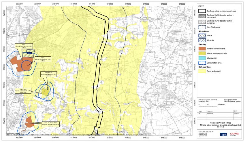
1.7.3 Mineral Safeguarded Sites and Areas
1.7.3.1 Sand and gravel resources are abundant and located throughout large areas of Norfolk (Norfolk County
Council, 2011). The closest sand and gravel quarry to the geology and ground conditions study area is
at Mangreen, which is approximately 400 m to the east of the onshore cable corridor search area (see
Figure 1.3). The quarry has been extended to the immediate south of the original quarry. Both the quarry
and its extension are operational with restoration required before the end of 2023. Two site allocations
for further southern extensions to Mangreen quarry have been put forward through the Minerals Site
Specific Allocations Development Plan Document.
1.7.3.2 The Minerals and Waste Development Framework identifies several Mineral Safeguarded Areas (sand
and gravel), which are located within the geology and ground conditions study area (in particular
sections of the onshore cable corridor search area and the site of the onshore HVAC booster station).
The onshore HVDC converter/HVAC substation is not located within a Mineral Safeguarded Area.
Guidance from Norfolk County Council on the mineral safeguarding process for aggregates (Norfolk
County Council, 2014) defines Mineral Safeguarded Areas as “those areas where there isn’t an
underlying mineral resources which may be of economic interest, which should be protected from
unnecessary sterilisation by non-mineral development”. The guidance also states that mineral deposits
found in Norfolk are highly variable and the data used to define the Mineral Safeguarded Areas is
general in nature. The guidance goes on to state that planning applications for non-mineral uses in
Mineral Safeguarded Areas should consult the Mineral Planning Authority on the assessment of the
mineral resources to identify the quality of any mineral and the depth of any overburden present.
11Chapter 1 – Geology and Ground Conditions
Preliminary Environmental Information Report
July 2017
Figure 1.3: Mineral extraction sites and mineral safeguarding areas.
12Chapter 1 – Geology and Ground Conditions
Preliminary Environmental Information Report
July 2017
Figure 1.3: Mineral extraction sites and mineral safeguarding areas.
13Chapter 1 – Geology and Ground Conditions
Preliminary Environmental Information Report
July 2017
Figure 1.3: Mineral extraction sites and mineral safeguarding areas.
14Chapter 1 – Geology and Ground Conditions
Preliminary Environmental Information Report
July 2017
Figure 1.3: Mineral extraction sites and mineral safeguarding areas.
15Chapter 1 – Geology and Ground Conditions
Preliminary Environmental Information Report
July 2017
Figure 1.3: Mineral extraction sites and mineral safeguarding areas.
16Chapter 1 – Geology and Ground Conditions
Preliminary Environmental Information Report
July 2017
Figure 1.3: Mineral extraction sites and mineral safeguarding areas.
17Chapter 1 – Geology and Ground Conditions
Preliminary Environmental Information Report
July 2017
Figure 1.3: Mineral extraction sites and mineral safeguarding areas.
18Chapter 1 – Geology and Ground Conditions
Preliminary Environmental Information Report
July 2017
Figure 1.3: Mineral extraction sites and mineral safeguarding areas.
19Chapter 1 – Geology and Ground Conditions
Preliminary Environmental Information Report
July 2017
Figure 1.3: Mineral extraction sites and mineral safeguarding areas.
20Chapter 1 – Geology and Ground Conditions
Preliminary Environmental Information Report
July 2017
1.7.4 Geology: superficial deposits and bedrock 1.7.4.8 BGS (n.d.) provide the following descriptions for each of the superficial deposits encountered within the
geology and ground conditions study area:
1.7.4.1 The superficial deposits and bedrock within the geology and ground conditions study area have been
identified using the Groundsure Geo Insight report (Groundsure, 2017b), BGS geology maps and • Peat may be an organic-rich clay; humic deposits - accumulation of wet, dark brown, partially
borehole logs. decomposed vegetation.
• Alluvium: Normally soft to firm consolidated, compressible silty clay, but can contain layers of silt,
Bedrock
sand, peat and basal gravel. A stronger, desiccated surface zone may be present.
1.7.4.2 The bedrock underlying the northern and central part of geology and ground conditions study area is • River Terrace Gravels comprise sand and gravel, locally with lenses of silt, clay or peat.
split between the Lewes Nodular Chalk of the White Chalk Subgroup (in the west) and the Wroxham • Head deposits are located in valley bases/sides and are described by the BGS as “Polymict
Crag Formation (in the east). The rest of the geology and ground conditions study area is underlain by deposit: comprises gravel, sand and clay depending on upslope source and distance from source.
Lewes Nodular Chalk of the White Chalk Subgroup. Poorly sorted and poorly stratified deposits formed mostly by solifluction and/or hillwash and soil
1.7.4.3 The White Chalk Subgroup is described by the BGS as “Chalk with flints. With discrete marl seams, creep. Essentially comprises sand and gravel, locally with lenses of silt, clay or peat and organic
nodular chalk, sponge-rich and flint seams throughout” (British Geological Society, n.d.). There are a material” (BGS, n.d.).
number of localised chalk exposures on the valley sides in the following locations: Aldeford, Aldeford • Brickearth varies from silt to clay, and is usually yellow-brown.
Common, Scotchwood Hills (southwest of Attlebridge) and Algarsthorpe Farm (southeast of • The Briton's Land Sand and Gravel Member consists of horizontal, massive and low angle planar
Marlingford). cross-bedded gravels and cobble gravels with thin seams of horizontal and rippled sand. The
lithology has a distinctive high flint content (c.85-89%) of which the majority is of non-chatter
1.7.4.4 The BGS describe the Wroxham Crag Formation as comprising “a sheet of interbedded gravels, sands, marked variety (c.78-85%). The gravels also contain a wide range of far-travelled crystalline
silts and clays. The gravels are dominated by flint (up to c.80%) and by quartz and quartzite (up to erratics including rocks of British and Scandinavian provenance.
c.60%), with far-travelled minor lithogies including Carboniferous chert, Rhaxella chert, Greensand • Till – Diamicton. The Weybourne Town Till Member consists of a highly calcareous silt and chalk-
chert, Spilsby Sandstone and felsic volcanic rocks from North Wales. The deposits are interpreted as rich matrix supported diamicton. It is generally massive in structure, but locally, (such as at the
estuarine and near-shore marine” (British Geological Society, n.d.). unit's stratotype locality), the diamicton is highly stratified, consisting of highly attenuated and
deformed inclusions of pre-existing till (Bacton Green Till Member).
Superficial deposits
• Sheringham Cliffs Formation is described by the BGS as “consisting of a thick glacigenic sequence
1.7.4.5 The majority of the geology and ground conditions study area is underlain by superficial deposits that contains several distinctive features such as the Mundesley Sand Member, which consists of
predominantly made up of different glacial deposits. In the northern part of the geology and ground stratified fine-grained sands; this is overlain by the laminated silts and clays of the Ivy Farm
conditions study area, the valley floors are dominated by Alluvium and Head. Peat is also present near Laminated Silt Member. Overlying these waterlain sediments are the Runton Till and Bacton Green
Beach Lane at the Hornsea Three landfall area. The higher ground is underlain by Head deposits, Till members; these are matrix-supported diamictons, which in turn, are overlain by thin units of
Britons Lane Sand and Gravel Member and Weybourne Town Till. From Bodham to Corpusty the clay (Trimingham Clay Member) and sand (Trimingham Sand Member). These deposits are
deposits are more varied but are still dominated by glacial deposits. These deposits include: Briton Lane truncated by the chalky Weybourne Town Till Member, a highly consolidated matrix-supported
Sand and Gravel Member, Head deposits, Weybourne Town Till, Sheringham Cliff Formation, Glacio- diamicton, and finally by the Runton Cliffs Sand and Gravel Member which forms the highest
fluvial deposits, Alluvium and Till. stratigraphical unit within the Formation” (BGS, n.d.).
1.7.4.6 Moving south, the superficial deposits are similar to the above but with areas of River Terrace Deposits • Lowestoft Formation (also Happisburgh Glaciagenic) forms an extensive sheet of chalky till,
in the valley floors. Other mapped strata include Brickearth, the Lowestoft Formation and the Leet Hills together with outwash sands and gravels, silts and clays. The till is characterised by its chalk and
Sand and Gravels Formation. The Leet Hills deposits are limited in their extent to the area of the existing flint content. The carbonate content of the till matrix is about 30%, and tills within the underlying
substation at Dunston and its immediate surrounds. Happisburgh Formation have less than 20%.
• Leet Hill Sand and Gravel Formations are “stratified and channelled proximal glaciofluvial outwash
1.7.4.7 The onshore HVAC booster station is underlain by Glacio-Fluvial deposits with a small area of Till at the deposits. Lithologically, the gravels are rich in flint and quartzose clasts, and contain gravel
site’s northern tip. The onshore HVDC converter/HVAC substation is underlain by the Lowestoft sourced from different geological strata in northern areas” (BGS, n.d.).
Formation.
21Chapter 1 – Geology and Ground Conditions
Preliminary Environmental Information Report
July 2017
1.7.4.9 BGS geological logs have been obtained for the geology and ground conditions study area. The location 1.7.5.8 The chalk is designated as a principal aquifer, which is defined by the BGS as “layers of rock or drift
of the boreholes and a summary of the borehole logs and are included in volume 6, annex 1.1: Borehole deposits that have high intergranular and/or fracture permeability - meaning they usually provide a high
Logs. level of water storage. They may support water supply and/or river base flow on a strategic scale. In
most cases, principal aquifers are aquifers previously designated as major aquifer” (BGS, n.d.).
1.7.5 Hydrogeology and groundwater
1.7.5.9 Chalk is highly transmissive but can store relatively little groundwater as the majority of flow and storage
1.7.5.1 The hydrogeology and groundwater conditions within the geology and ground conditions study area
is attributable to fractures. These characteristics mean that it is susceptible to drought with rapid flow
have been identified using the Groundsure Geo Insight and Enviro Insight reports (Groundsure, 2017b),
and discharge occurring after it recharges in winter (i.e. most recharges passes rapidly through the
hydrogeological maps, BGS geology maps and aquifer maps.
aquifer system).
Bedrock
Superficial deposits
1.7.5.2 In North Norfolk, the Chalk aquifer is dominated by groundwater flow via fissures and bedding planes
1.7.5.10 The hydrogeology of the superficial deposits will be dominated by localised perched groundwater
which tend to be more prevalent in the top 30 to 60 m of the chalk leading to a high flow potential at
generally present in the more permeable strata such as sand and gravels or more localised permeable
these depths. Depth to groundwater and ground water flow direction is heavily influenced by the
lenses with more clay dominated strata such as Till. Groundwater flow within the superficial deposits will
overlying topography. Seasonal fluctuations in groundwater levels are likely to occur based on the low
be more linked to local topography with potential for seepages when more permeable layers overlie less
storage capacity of the chalk with such variation being more prevalent towards the higher topographic
permeable layers.
areas. Inter-seasonal variation in groundwater levels are also likely to occur based on the preceding
weather conditions (i.e. higher groundwater levels following wetter than typical periods and vice versa). 1.7.5.11 All the superficial deposits underlying the geology and ground conditions study area, with the exception
The chalk is a well utilised groundwater source as detailed below in the description of licensed of localised peat and Brickearth, are all classified as either secondary A aquifer or secondary
abstraction boreholes and SPZs. Undifferentiated. The peat is considered to be unproductive strata defined as having negligible
significance for water supply or river base flow. Brickearth deposits are classified as secondary B
1.7.5.3 Chalk is generally located at approximately 10 m Above Ordnance Datum along the geology and ground
aquifers.
conditions study area,indicating a significant depth of drift along much of the route with zones of thicker
drift deposits along former glacial channels. The presence of overlying superficial deposits, including 1.7.5.12 Secondary A aquifer is defined by the Environment Agency (n.d.) as “permeable layers capable of
lower permeability clays means that the chalk will locally be a confined aquifer. supporting water supplies at a local rather than strategic scale, and in some cases forming an important
source of base flow to rivers. These are generally aquifers formerly classified as minor aquifers”.
1.7.5.4 The Wroxham Crag Formation is less well utilised for supply due to its unconsolidated nature (i.e. loose
material making construction and use of abstraction wells more problematic than the underlying chalk). 1.7.5.13 Secondary Undifferentiated - has been assigned in cases where it has not been possible to attribute
either category A or B to a rock type. In most cases, this means that the layer in question has previously
1.7.5.5 Groundwater flow in the upper part of the geology and ground conditions study area is towards the north.
been designated as both minor and non-aquifer in different locations due to the variable characteristics
Groundwater levels are high at Hempstead due to a divide between groundwater catchments. To the
of the rock type.
north of the divide groundwater flow will be to the north, whereas to the south of the divide groundwater
flow will be in a southerly direction. 1.7.5.14 The Environment Agency (n.d.) define secondary B aquifers as “predominantly lower permeability layers
which may store and yield limited amounts of groundwater due to localised features such as fissures,
1.7.5.6 Towards the centre of the geology and ground conditions study area, groundwater flow direction is
thin permeable horizons and weathering. These are generally the water-bearing parts of the former non-
determined by the river valleys which form the dominant topographic features. A groundwater divide is
aquifers”.
located at Heydon (E 610642 N 327003); to the north of this divide flow is generally to the north. South
of the divide, groundwater flow is to the south and southeast. Water Framework Directive
1.7.5.7 The direction of groundwater flow in the southern end of the geology and ground conditions study area, 1.7.5.15 In relation to groundwater the Water Framework Directive (WFD) is designed to:
and the onshore HVDC converter/HVAC substation, also follows the dominant topographic features of
• Promote the sustainable use of water;
the river valleys with corresponding groundwater flows to the east.
• Reduce pollution of water, especially by ‘priority’ and ‘priority hazardous’ substances; and
• Ensure progressive reduction of groundwater pollution.
22You can also read