Hydrogeological Behaviour and Geochemical Features of Waters in Evaporite-Bearing Low-Permeability Successions: A Case Study in Southern Sicily ...
←
→
Page content transcription
If your browser does not render page correctly, please read the page content below
applied
           sciences
Article
Hydrogeological Behaviour and Geochemical
Features of Waters in Evaporite-Bearing
Low-Permeability Successions: A Case Study in
Southern Sicily, Italy
Pietro Rizzo 1 , Chiara Cappadonia 2, * , Edoardo Rotigliano 2 , Paola Iacumin 1 ,
Anna Maria Sanangelantoni 1 , Giulia Zerbini 1 and Fulvio Celico 1
 1    Department of Chemistry, Life Sciences and Environmental Sustainability, University of Parma, Parco Area
      delle Scienze 157/A, 43124 Parma, Italy; pietro.rizzo@unipr.it (P.R.); paola.iacumin@unipr.it (P.I.);
      annamaria.sanangelantoni@unipr.it (A.M.S.); giulia.zerbini@studenti.unipr.it (G.Z.);
      fulvio.celico@unipr.it (F.C.)
 2    Department of Earth and Marine Sciences, University of Palermo, Via Archirafi 22, 90123 Palermo, Italy;
      edoardo.rotigliano@unipa.it
 *    Correspondence: chiara.cappadonia@unipa.it; Tel.: +39-091-2386-4664

 Received: 4 September 2020; Accepted: 17 November 2020; Published: 18 November 2020

 Featured Application: The research suggests an approach for refining the guidelines to be used in
 studying heterogeneous media and planning optimal monitoring networks and protocols for several
 anthropogenic purposes (e.g., environmental monitoring of landfills or contaminated sites managing).

 Abstract: Knowledge about the hydrogeological behaviour of heterogeneous low-permeability media
 is an important tool when designing anthropogenic works (e.g., landfills) that could potentially
 have negative impacts on the environment and on people’s health. The knowledge about the
 biogeochemical processes in these media could prevent “false positives” when studying groundwater
 quality and possible contamination caused by anthropogenic activities. In this research, we firstly
 refined knowledge about the groundwater flow field at a representative site where the groundwater
 flows within an evaporite-bearing low-permeability succession. Hydraulic measurements and
 tritium analyses demonstrated the coexistence of relatively brief to very prolonged groundwater
 pathways. The groundwater is recharged by local precipitation, as demonstrated by stable isotopes
 investigations. However, relatively deep groundwater is clearly linked to very high tritium content
 rainwater precipitated during the 1950s and 1960s. The deuterium content of some groundwater
 samples showed unusual values, explained by the interactions between the groundwater and certain
 gases (H2 S and CH4 ), the presences of which are linked to sulfate-reducing bacteria and methanogenic
 archaea detected within the saturated medium through biomolecular investigations in the shallow
 organic reach clayey deposits. In a wider, methodological context, the present study demonstrates
 that interdisciplinary approaches provide better knowledge about the behaviour of heterogeneous
 low-permeability media and the meaning of each data type.

 Keywords: conceptual model; evaporites; bacterial community; stable isotopes; tritium; Southern Italy

1. Introduction
   The Mediterranean region was affected by a pervasive “salinity crisis” during the Messinian,
when it was progressively restricted and partially isolated from the Atlantic Ocean by a combination

Appl. Sci. 2020, 10, 8177; doi:10.3390/app10228177                                www.mdpi.com/journal/applsci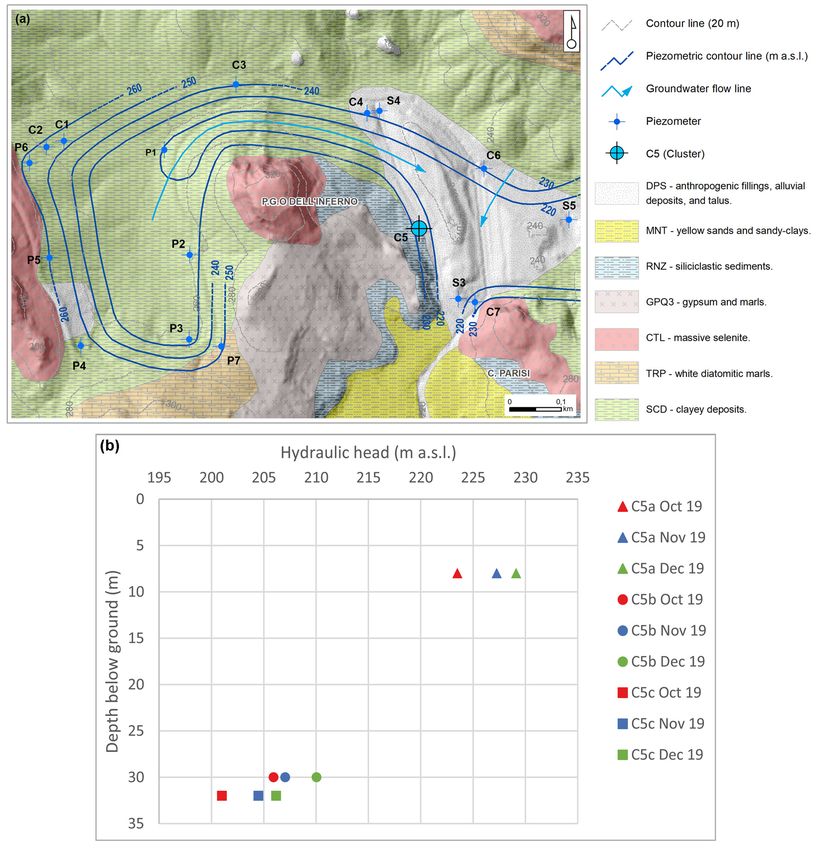
Appl. Sci. 2020, 10, 8177                                                                           2 of 24

of tectonic and glacio-eustatic processes [1–4] that resulted in the deposition of large volumes of
evaporitic sediments [5,6]. The Messinian Sicilian Basins are very important geologic systems for
analysing these evaporite successions, in view of their lateral variations and subsequent deformation [7].
Their syn-tectonic evolution is in fact fundamental to reconstructing the timing and geometry of
the propagating thrust belt [8,9]. In particular, progressive filling of sub-basins led to the formation
of aquifer systems characterised by the coexistence of very low permeability clay successions and
evaporitic lenses/horizons [10]. From a hydrochemical point of view, both low- and high-salinity
groundwaters may be found associated with the mineralogical features described above.
     Several hydrogeological and geochemical studies have been carried out in such settings.
Some of these studies provided preliminary characterisations through the analysis of single sampling
campaigns [11–13], whereas others investigated in greater detail the hydrogeological behaviour and the
hydrochemical evolution over time based on more prolonged and multidisciplinary approaches [14–16].
Worldwide, a variety of conceptual models have been proposed for groundwater circulation in
evaporite deposits. In some systems, the hydrogeology and hydrochemistry of the evaporitic aquifers
are significantly influenced by deep ascending regional fluids [17–20]; conversely, at other sites,
the hydrogeology and hydrochemistry of the studied system are influenced by the mixing of saline
groundwater (flowing through evaporitic rocks) with more diluted waters flowing through nearby
porous aquifers [21], with the possible influence of surface waters [22,23] or peat layers [24].
     The main objective of this study was to refine knowledge about the hydrogeological behaviour of
such systems. Because of the expected complexity, the study was carried out by merging hydraulic
head measurements, isotopic analyses, and microbial community investigations, as to acquire a broad
spectrum of complementary hydraulic and biogeochemical information.
     The hydraulic head measurements were carried out to analyse the groundwater flow field from
a three-dimensional perspective and investigate the existence of possible vertical flow components
influencing the groundwater pathways and residence times.
     The isotopic analyses were conducted to refine knowledge about the groundwater origins
(stable isotopes of oxygen and deuterium) and residence times (tritium). Isotopes, together with
chemical features, are among the major groundwater tracers traditionally and widely employed in
hydrogeological studies (e.g., [25–29]).
     The microbial community investigations were performed to analyse the isotopic signatures of the
groundwater from a biogeochemical perspective, as to avoid incorrect interpretations of geochemical
data. Microbial communities are influenced by the physicochemical features of the environment in
which they live and are excellent investigative tools in several hydrogeological scenarios. The efficacy
of using microorganisms for specific hydrogeological purposes has been verified in several settings
that are partially comparable with that addressed in this study, such as karstified media (e.g., [30,31]),
low-permeability media (e.g., [32,33]), and high-salinity groundwaters (e.g., [34]).
     The usefulness and the efficacy of a coupled isotopic-microbiological approach has been verified
in other complex hydrogeological settings (e.g., [35]), taking into consideration how microorganisms
migrate in the subsurface (e.g., [36]).
     Taking into consideration the key items highlighted in previous papers, this study was devoted
mainly to examining in depth the role of certain hydraulic heterogeneities in influencing the groundwater
flow field, as well as the role of microbial communities in influencing the isotopic signature of
groundwater. Based on this goal, and according to the successful results of former studies performed
at the same scale in similar setting [14–16], this first step of the research was carried out within a
relatively narrow experimental site (in the order of 1 km2 ). In fact, minimising the extension of the
study site at this stage, allowed to minimise the distance between investigation boreholes and wells,
and maximise the opportunity to understand the heterogeneity degree of the studied system from the
geological, hydrogeological and biogeochemical points of view.
Appl. Sci. 2020, 10, 8177                                                                                   3 of 24

           2. Study Area
                  The study area is located in south-western Sicily, between the small towns of Siculiana and Montallegro
            (Figure 1). It geologically corresponds (Figure 2a; [37]) to the south to southeast-vergent Sicilian Fold and
Appl. Sci. 2020,
            Thrust10,Belt
                      x FOR   PEER
                          (FTB, [38])REVIEW
                                      bordered by the Gela thrust front and Kabilian-Calabrian thrust front. The FTB is an        3 of 24
            element of the collisional complex of Sicily, which also includes a late Pliocene-Quaternary foredeep (Gela
2. Studyforedeep),
             Area onlapping the frontal sector of the thrust belt in the southern part of the island, its offshore area,
            and the Pelagian-Iblean foreland with its African crust. In particular, the southern and central parts of the
      TheFTB  study
                 (Figurearea
                           2b),is
                                arelocated    in south-western
                                    characterised   by the outcropping  Sicily,
                                                                           of the between     the evaporitic
                                                                                  most complete     small towns       of Siculiana
                                                                                                              succession   of the   and
Montallegro        (Figure 1). Itformation
           “Gessoso-Solfifera”       geologically       corresponds
                                               of the Messinian           (Figure 2a; [37]) to the south to southeast-vergent
                                                                   age [39].
Sicilian FoldThe    andevaporitic
                           Thrust deposits
                                     Belt (FTB,      [38])3) bordered
                                                (Figure                   by the
                                                             mainly consist          Gela thrust
                                                                                of limestone,        frontsalt,
                                                                                               gypsum,      and    Kabilian-Calabrian
                                                                                                                 and  numerous
            intercalations   of clays, marls,  and  carbonates.   Gypsum     strata
thrust front. The FTB is an element of the collisional complex of Sicily, which alsoare composed   of various   kinds of includes
                                                                                                                         selenite a late
            (branching, banded, and massive) and detrital gypsum layers alternating with marl and carbonate.
Pliocene-Quaternary foredeep (Gela foredeep), onlapping the frontal sector of the thrust belt in the
            The Messinian units overlie diatomitic laminites (Tripoli formation [Fm.]: TRP) and clay deposits of
southernlate  part   of the island,
                 Tortonian              its offshore
                              to Early Messinian      age,area,  andsuccession
                                                           and the     the Pelagian-Iblean
                                                                                   is overlain by foreland     withcalcilutites
                                                                                                   Pliocene marly     its African crust.
In particular,        theTRB).
            (Trubi Fm.:     southern      andsequence
                                  The whole       central[41] parts   of the
                                                                is locally       FTBby(Figure
                                                                           overlain                2b), Pliocene
                                                                                         middle–upper    are characterised
                                                                                                                    marly clays by the
outcropping (Monte ofNarbone
                       the most  Fm.:complete
                                       NRB). Sandy evaporitic
                                                       clays and succession       of the “Gessoso-Solfifera”
                                                                   arenites (Montallegro    Fm.: MNT), clays breccias  formation
                                                                                                                          (BRC), of the
            and  turbiditic
Messinian age [39].          calcarenites  (Agrigento     Fm.: GRG)    are the  more   recent Pleistocene  units.

                                       Figure 1. Geographic setting and general map of the study area.
                                Figure 1. Geographic setting and general map of the study area.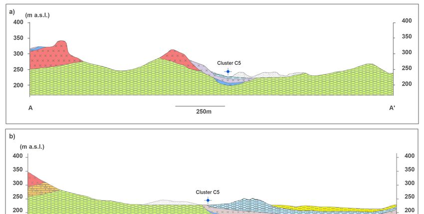
Appl. Sci. 2020, 10, 8177                                                                                          4 of 24
Appl. Sci. 2020, 10, x FOR PEER REVIEW                                                                                                   4 of 24

                       2. (a) Mt. Etna edifice and main elements of the collisional complex of Sicily: Kabylian-Calabrian
      Figure 2.Figure
                  (a) Mt.    Etna edifice and main elements of the collisional complex of Sicily: Kabylian-
               thrust basement—KCB; fold and thrust belt—FTB; Gela foredeep—GF; Pelagian-Iblean foreland—PIF;
      Calabrian    thrust basement—KCB; fold and thrust belt—FTB; Gela foredeep—GF; Pelagian-Iblean
               (b) structural map of Sicily (modified from [40]) highlighting the spatial distribution of the evaporite
      foreland—PIF;
               outcrops(b)in structural
                              Sicily (after map
                                             [39]): of
                                                    (1) Sicily  (modified
                                                         Plio-Pleistocene     from(2)[40])
                                                                            cover,            highlighting
                                                                                        volcanics,               the spatial
                                                                                                     (3) evaporites           distribution
                                                                                                                       (Messinian),
      of the evaporite outcrops in Sicily (after [39]): (1) Plio-Pleistocene cover, (2) volcanics, (3) evaporites
               (4)  upper  Miocene-lower      Pliocene  deformed     foreland deposits,   (5) upper   Oligocene-lower     Miocene
               deformed
      (Messinian),    (4) foreland   deposits, (6) Kabilian-Calabrian
                           upper Miocene-lower                           crystalline units,
                                                            Pliocene deformed               (7) Sicilide
                                                                                       foreland          units, (8)(5)
                                                                                                     deposits,      Meso-Cenozoic
                                                                                                                        upper Oligocene-
               carbonate platform deformed units (Sicilian-Maghrebian shallow-water units), (9) Meso-Cenozoic
      lower Miocene deformed foreland deposits, (6) Kabilian-Calabrian crystalline units, (7) Sicilide units,
               slope-to-deep-basin deformed units (Sicilian-Maghrebian deep-water units), and (10) Meso-Cenozoic
      (8) Meso-Cenozoic       carbonate
               carbonate platform            platform
                                       not-deformed       deformed
                                                       units            units (Sicilian-Maghrebian
                                                              (Sicilian-Maghrebian    foreland).              shallow-water units), (9)
      Meso-Cenozoic slope-to-deep-basin deformed units (Sicilian-Maghrebian deep-water units), and (10)
               In greatercarbonate
      Meso-Cenozoic        detail, a firstplatform
                                           and a second   sedimentary cycle
                                                     not-deformed         units[42] are distinguished in theforeland).
                                                                                 (Sicilian-Maghrebian             Messinian evaporites,
          which are separated by an angular unconformity. The first cycle comprises [43]: carbonate deposits (Calcare
          di Base Fm.: BEC), massive selenite (Cattolica Fm.: CTL), and a salt unit (Clastic Ca-sulfates, Mg and
      The evaporitic deposits (Figure 3) mainly consist of limestone, gypsum, salt, and numerous
          K salts, and halite unit: SLT). The younger second cycle is mainly characterised by thin gypsum layers
intercalations
          (balatinoofand
                       clays,   marls,
                         selenite:         andmarls
                                    GPQ) and     carbonates.
                                                      layers (upperGypsum       strata
                                                                      evaporites,         are Fm.:
                                                                                   Pasquasia    composed     ofinterbedded
                                                                                                    GPQ) levels   various kinds of
selenite with
          (branching,      banded,
               detrital mud,             and massive)
                              silt, sandstones,             and detrital
                                                 and conglomerates    overlaingypsum        layers
                                                                               by siliciclastic       alternating
                                                                                                sediments            with
                                                                                                           (mainly silty     marl and
                                                                                                                         clays;
          Arenazzolo    Fm.: RNZ),    characterised by  marked   organic  matter  levels.
carbonate. The Messinian units overlie diatomitic laminites (Tripoli formation [Fm.]: TRP) and clay
               The Tortonian
deposits of late      complexity of  to the geological
                                         Early          setting
                                                Messinian         of the
                                                               age,   and area
                                                                            theis succession
                                                                                   increased to is beoverlain
                                                                                                      a consequence     of the marly
                                                                                                                by Pliocene
          Plio-Pleistocene tectonic phases that generated the fold and thrust belts and high-angle faults with
calcilutites (Trubi Fm.: TRB). The whole sequence [41] is locally overlain by middle–upper Pliocene
          subsequent lateral contacts between the Messinian gypsum units and the older clayey deposits.
marly clays     (MontetheNarbone
          In addition,                    Fm.: NRB).
                             wide distribution           Sandy
                                                   of soluble  rocksclays   and
                                                                       in this     arenites
                                                                               sector          (Montallegro
                                                                                       of Sicily  is responsible Fm.:    MNT), clays
                                                                                                                 for intense
breccias karstic
           (BRC),processes,
                      and turbiditic
                              producingcalcarenites
                                            a great variety(Agrigento        Fm.:and
                                                             of either epigeous      GRG)     are the
                                                                                        hypogeous        more recent
                                                                                                      landforms  [41].     Pleistocene
units.
     In greater detail, a first and a second sedimentary cycle [42] are distinguished in the Messinian
evaporites, which are separated by an angular unconformity. The first cycle comprises [43]: carbonate
deposits (Calcare di Base Fm.: BEC), massive selenite (Cattolica Fm.: CTL), and a salt unit (Clastic Ca-
sulfates, Mg and K salts, and halite unit: SLT). The younger second cycle is mainly characterised by
Appl. Sci. 2020,
Appl.10,
Sci.x 2020,
FOR10,
PEER
8177 REVIEW 5 of 24 5 of 24
Figure 3. Schematic stratigraphic sequence of the evaporites in south-western Sicily (after [44]):
Figure 3. Schematic stratigraphic
clayey deposits sequence Serravallian);
(SCD—Tortonian-middle of the evaporites
Messinianin evaporites—first
south-westerncycle: Sicily (after
white [44]): clayey
diatomitic
marls, Tripoli Fm. (TRP-Messinian); carbonate breccias and clastic gypsum,
deposits (SCD—Tortonian-middle Serravallian); Messinian evaporites—first cycle: white diatomitic Calcare di Base Fm.
(BEC—Messinian); massive selenite, Cattolica Fm. (CTL—Messinian); clastic Ca-sulfates, Mg- and
marls, Tripoli Fm. (TRP-Messinian); carbonate breccias and clastic gypsum, Calcare di Base Fm.
K-salts, and halite unit, forming a salt unit (SLT—Messinian); second cycle: gypsum-arenites and
(BEC—Messinian); massive selenite, Cattolica Fm. (CTL—Messinian); clastic Ca-sulfates, Mg- and K-
limestones and carbonate arenites, Pasquasia Fm. (GPQ1; GPQ2—Messinian); gypsum (balatino and
salts, andselenite)
halite and
unit, forming
marls, a salt
Pasquasia Fm. unit (SLT—Messinian);
(GPQ3–Messinian); second
Siliciclastic cycle:
sediments rich gypsum-arenites
in organic matter, and
limestones and carbonate
Arenazzolo arenites, Pasquasia
Fm. (RNZ–Messinian); Fm. (GPQ1;
marly calcilutites, GPQ2—Messinian);
Trubi Fm. (TRB—Early Pliocene); gypsum (balatino
marls, marly clays, and
sandy clays, Monte Narbone Fm. (NRB—middle–upper Pliocene); yellow sands and
selenite) and marls, Pasquasia Fm. (GPQ3–Messinian); Siliciclastic sediments rich in organic matter,lagoonal sandy-clays,
Montallegro Fm. (MNT—lower Pleistocene); turbiditic calcarenites, Agrigento Fm. (GRG—lower
Arenazzolo Fm. (RNZ–Messinian); marly calcilutites, Trubi Fm. (TRB—Early Pliocene); marls, marly
Pleistocene); clay breccias (BRC—lower Pleistocene).
clays, sandy clays, Monte Narbone Fm. (NRB—middle–upper Pliocene); yellow sands and lagoonal
sandy-clays,
FromMontallegro Fm. (MNT—lower
a morpho-structural standpoint, the Pleistocene);
landscape is turbiditic calcarenites,
characterised by a systemAgrigento
of gentleFm.
anticlines and synclines extending parallel to the
(GRG—lower Pleistocene); clay breccias (BRC—lower Pleistocene).NW-SE trend of the FTB and large blocks of evaporitic
rocks encircled by clayey deposits, with frequent relief inversion produced by differential erosion
phenomena [39]. The folded relief is also intersected by perpendicular faults connecting different parts
The complexity of the geological setting of the area is increased to be a consequence of the Plio-
of the evaporites bodies and/or clayey deposits. The area is characterised by a series of slightly sloped
Pleistocene tectonic
fluvial terraces,phases
frequentlythat generated
cut in their upperthe
partsfold and
by long thrust
gullies belts and
and V-shaped high-angle
valleys. faults with
Karst processes
subsequent havelateral contacts
affected gypsum between the Messinian
areas, resulting gypsum
in a great variety unitslandforms,
of surface and the such
olderas clayey deposits. In
poljes, karren,
addition, and
the gypsum
wide distribution
bubbles. Onof thesoluble rocks morphogenetic
clayey slopes, in this sector of Sicily is
processes responsible
produced for intense
landforms such as karstic
processes,shallow landslides,
producing rills,variety
a great and gullies [45]. epigeous and hypogeous landforms [41].
of either
Following the above-mentioned general geological setting, in the study area, the Mio-Pliocene
From a morpho-structural standpoint, the landscape is characterised by a system of gentle
deposits consisting of an evaporite series and pre-evaporite strata are involved in a wide range
anticlinesofand
fold synclines
structures on extending
a NNW-SSE parallel
axis andtoarethe NW-SE
capped trend deformed
by weakly of the FTB and large
Pleistocene blocks of
deposits
evaporiticandrocks encircled
Quaternary by clayey
terrains. deposits,
The shapes of thewith frequent
structures relief inversion
are irregular produced
fashion because by differential
of the different
erosion phenomena [39]. The offolded
stratigraphic thicknesses relief rocks,
the evaporitic is also intersected
which by perpendicular
were also controlled faults
by active thrust and connecting
fold
structures at the time of deposition [7] and by the significant competence contrasts
different parts of the evaporites bodies and/or clayey deposits. The area is characterised by a series between various
of slightlyformations described in Figure 3, such as coarse-grained gypsum, muds, silty clays, and silts. In general,
sloped fluvial terraces, frequently cut in their upper parts by long gullies and V-shaped
the evaporitic deposits of the second cycle (gypsum and marls; GPQ1; GPQ2 and GPQ3) locally overlie
valleys. Karst processes have affected gypsum areas, resulting in a great variety of surface landforms,
such as poljes, karren, and gypsum bubbles. On the clayey slopes, morphogenetic processes
produced landforms such as shallow landslides, rills, and gullies [45].
Following the above-mentioned general geological setting, in the study area, the Mio-Pliocene
Appl. Sci. 2020, 10, 8177 6 of 24
Appl. Sci. 2020, 10, x FOR PEER REVIEW 6 of 24
the massive selenites of the CTL (first cycle) and the SCD with an erosional unconformity, and are in
general,
turn overlain the evaporitic
by the deposits
silty clays of theofRNZ.
the second cycle (gypsum and marls; GPQ1; GPQ2 and GPQ3)
locally overlie the massive selenites of the CTL (first cycle) and the SCD with an erosional
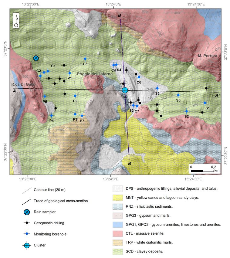
To reconstruct the local geology, the stratigraphic logs of 18 geognostic boreholes and 22 piezometers
unconformity, and are in turn overlain by the silty clays of the RNZ.
were taken intoToconsideration,
reconstruct the and
local ageology,
geological map (Figurelogs
the stratigraphic 4) was
of 18constructed, which is
geognostic boreholes marked
and 22 by the
outcropping of several
piezometers werecomponents of the whole
taken into consideration, and succession. Based
a geological map on4)the
(Figure wasavailable stratigraphic
constructed, which data,
is marked by the outcropping of several components of the whole
two interpretative profiles extending E–W and N–S were also drawn (Figure 5). succession. Based on the available
stratigraphic data, two interpretative profiles extending E–W and N–S were also drawn (Figure 5).
Figure 4. Geological map of
Figure 4. Geological the
map of study area
the study areaand
and location
location ofof
thethe geognostic
geognostic and monitoring
and monitoring boreholes.boreholes.
The two profiles depictdepict
The two profiles the general expected
the general settingofof
expected setting thethe area,
area, with with a folded
a folded regular sequence
regular sequence
marked bymarked by first
first cycle cyclegypsum
(CTL) (CTL) gypsum
layerslayers overlaying
overlaying thethe diatomites (TRP)
diatomites (TRP) levels
levelsorordirectly
directlyin in contact
contact on the Tortonian clayey deposits (SCD). The second cycle evaporitic layers (GPQ1, GPQ2,
on the Tortonian clayey deposits (SCD). The second cycle evaporitic layers (GPQ1, GPQ2, GPQ3,
GPQ3, and RNZ) cover in sequence the CTL only along the north-south profile, and elsewhere
and RNZ)directly
coveroverlie
in sequence
the SCD.the CTL
At the only
base, thealong
whole the
area north-south
is characterisedprofile, and elsewhere
by the continuous thick directly
overlie the SCD. At
Tortonian thelayer
clayey base, the In
(SCD). whole area isflank
the southern characterised by athe
of the anticline, continuous
thick thick Tortonian
sandy/sandy-clayey
clayey layer (SCD). In the southern flank of the anticline, a thick sandy/sandy-clayey (MNT) layer
outcrops, covering the RNZ. In the central sector of the study area, along the main drainage surficial
line, the evaporitic terrains are covered by a large patch of mainly alluvial quaternary deposits and
characterised by high organic matter content.
Appl. Sci. 2020, 10, x FOR PEER REVIEW                                                                      7 of 24

(MNT) layer outcrops, covering the RNZ. In the central sector of the study area, along the main
drainage     surficial
Appl. Sci. 2020, 10, 8177 line, the evaporitic terrains are covered by a large patch of mainly alluvial
                                                                                                  7 of 24
quaternary deposits and characterised by high organic matter content.

                           Figure 5.
                           Figure    Geological cross-sections
                                  5. Geological cross-sections (see
                                                               (see Figure
                                                                    Figure 44 for
                                                                              for traces).
                                                                                  traces).

3. Materials and Methods
3. Materials and Methods
     An interdisciplinary approach was employed in order to analyse the groundwater flow field and
     An interdisciplinary approach was employed in order to analyse the groundwater flow field and
the hydrogeological behavior of the studied system from a three-dimensional perspective. The possible
the hydrogeological behavior of the studied system from a three-dimensional perspective. The
influence of vertical flow on groundwater pathways and residence times was explored by merging
possible influence of vertical flow on groundwater pathways and residence times was explored by
hydrogeological and isotopic investigations. Microbial community analyses were conducted to
merging hydrogeological and isotopic investigations. Microbial community analyses were conducted
investigate the isotopic signature of the groundwater from a biogeochemical perspective, to ensure that
to investigate the isotopic signature of the groundwater from a biogeochemical perspective, to ensure
the results of the isotopic analyses were correctly interpreted, with emphasis on the deuterium content.
that the results of the isotopic analyses were correctly interpreted, with emphasis on the deuterium
     Graphic images were obtained using QGIS, Adobe Illustrator and Microsoft Excel.
content.
     Graphic imagesInvestigations
3.1. Hydrogeological    were obtained using QGIS, Adobe Illustrator and Microsoft Excel.

      From May 2011
3.1. Hydrogeological      to November 2019, the hydraulic head at the piezometers was measured on
                      Investigations
a weekly to monthly basis using a water level meter to reconstruct the groundwater flow net and
      From May
its evolution     2011
               over      to November
                     time.               2019,investigate
                             To specifically    the hydraulic
                                                            the head  at the
                                                                vertical      piezometers
                                                                         zonation            was measured
                                                                                     of the hydraulic   head on
                                                                                                              and a
weekly   to monthly    basis  using a water   level meter   to reconstruct  the  groundwater
the isotopic/microbiological features within the heterogeneous medium, one multilevel groundwaterflow net  and  its
evolution
monitoringover   time.
             system      To specifically
                      (cluster type) was investigate   the vertical
                                           drilled in August   2019: zonation   of the
                                                                     the C5 cluster      hydraulic
                                                                                      (Figure       headincluded
                                                                                              6), which   and the
isotopic/microbiological     features  within   the  heterogeneous    medium,     one   multilevel  groundwater
three piezometers screened at different depths (C5a, C5b, and C5c). The C5 cluster was drilled close to a
monitoring   system (cluster
former and abandoned           type) was
                           piezometer   (30drilled
                                            m deep inand
                                                      August
                                                          fully2019: the C5incluster
                                                                screened),     which(Figure   6), which
                                                                                       the sampled       included
                                                                                                    groundwater
three  piezometers   screened   at different  depths  (C5a,  C5b,  and C5c).   The C5   cluster was  drilled
was characterised by high tritium content (36.5 tritium units [T.U.]), to also deeply investigate the origin close
to  a former  and   abandoned      piezometer    (30  m  deep   and  fully screened),     in which
of this apparent anomaly. The other piezometers ranged in depth between 15 and 40 m, depending on   the  sampled
groundwater
the local depthwas   characterised
                 of the  groundwater  byhead.
                                          high tritium content (36.5 tritium units [T.U.]), to also deeply
investigate the origin of this apparent anomaly. The other piezometers ranged in depth between 15
and 40 m, depending on the local depth of the groundwater head.
Appl. Sci. 2020, 10, x FOR PEER REVIEW 8 of 24
Appl. Sci. 2020, 10, 8177 8 of 24
Figure 6. Cluster C5: stratigraphy, screened intervals, and water levels in December 2019.
Figure 6. Cluster C5:
DPS-anthropogenic stratigraphy,
fillings, alluvial screened
deposits, intervals,
and talus and water levels
(Quaternary); in December 2019.
RNZ-siliciclastic DPS-
sediments
anthropogenic
with fillings,
high organic matter alluvial
content, deposits,
Arenazzoloand
Fm.talus (Quaternary);
(Messinian); GPQ1RNZ-siliciclastic sediments with
and GPQ2-gypsum-arenites and
high organic
limestones andmatter
carbonatecontent, Arenazzolo
arenites, Fm.
Pasquasia Fm.(Messinian); GPQ1 and GPQ2-gypsum-arenites and
(Messinian).
limestones and carbonate arenites, Pasquasia Fm. (Messinian).
3.2. Isotopic Investigations
3.2. Isotopic Investigations
Groundwater samples for stable isotope (δ18/16 O and δ2/1 H) and tritium (3 H) analyses were
collected four times samples
Groundwater (January, forJune, September
stable isotopeand December
(δ18/16 O and 2019),
δ2/1H) together
and tritiumwith(the
3H) hydraulic
analyses head
were
measurements. During the same observation period, rainwater samples for δ( 18/16 O), δ(2/1 H) and
collected four times (January, June, September and December 2019), together with the hydraulic head
tritium analyses During
measurements. were collected
the same monthly (depending
observation period, onrainwater
the amount of precipitation)
samples from
for δ(18/16O), one
δ(2/1H) rain
and
sampler installedwere
tritium analyses at thecollected
test sitemonthly
(Figure 4). The rainfall
(depending on thewasamount
collectedof using ten-liter from
precipitation) polyethylene
one rain
bottles
sampler containing
installedabout
at the300testmL of (Figure
site Vaseline4).
oil The
to prevent
rainfallevaporation.
was collectedOil using
contamination
ten-liter was carefully
polyethylene
avoided by syringing
bottles containing the water
about 300 mL samples out of oil
of Vaseline the to
bottles.
prevent All evaporation.
the samples were transported to was
Oil contamination the
laboratory in a refrigerated box.
carefully avoided by syringing the water samples out of the bottles. All the samples were transported
to theStable isotopeinanalyses
laboratory were carried
a refrigerated box. out at the Isotope Geochemistry Laboratory of the University
of Parma, ◦
StableItaly, usinganalyses
isotope a water equilibrator
were carried at 18outCatequipped
the Isotope with aGeochemistry
Finnigan Delta XP spectrometer.
Laboratory of the
For oxygen isotope determination, 5 cm 3 of water was equilibrated with pure CO , whereas
University of Parma, Italy, using a water equilibrator at 18 °C equipped with a Finnigan 2 Delta for
XP
hydrogen isotopes, 3
5 cm of waterdetermination,
was equilibrated with
spectrometer. For oxygen isotope 5 cm 3 of pure
waterHwas
2 (platinum wire with
equilibrated was pure
used COas a2,
catalyser
whereas of forgas-liquid
hydrogenwater equilibration).
isotopes, The isotope
5 cm3 of water ratio is expressed
was equilibrated with pureas: H2 (platinum wire was
used as a catalyser of gas-liquid water equilibration). The isotope ratio
! is# expressed as:
A/B R
" A/B
A/B i Ri
δ = A/B/ −1 = / − 1 103 % (1)
/ i/RF R A/B R
δ / = /
RF −1= / − 1 10
RF ‰ (1)
where A is 1818O or 22H, B is 16 O or 1 H, R is the ratio of the isotopic abundances, i the sample of interest,
where A is O or H, B is 16O or 1H, R is the ratio of the isotopic abundances, i the sample of interest,
% = 10−3 , and RF is the primary international standard of reference (in our case VSMOW-SLAP).
−3
‰ = 10 , and RF is the primary international standard of reference (in our case VSMOW-SLAP). The
The analyses3 of 3 H were carried out at the Isotope Geochemistry Laboratory of the University of
analyses of H were carried out at the Isotope Geochemistry Laboratory of the University of Trieste,
Trieste, Italy. Following other authors (e.g., [46]), the samples followed the procedure of the preventive
Italy. Following other authors (e.g., [46]), the samples followed the procedure of the preventive
electrolytic enrichment of tritium was applied to the samples to decrease measurement errors. In this
electrolytic enrichment of tritium was applied to the samples to decrease measurement errors. In this
process, the 250 g of the water sample was expected to be reduced to 20 g by electrolysis.
process, the 250 g of the water sample was expected to be reduced to 20 g by electrolysis.
The analyses for the determination of the tritium activity were carried out according to the
The analyses for the determination of the tritium activity were carried out according to the
procedures provided by the International Atomic Energy Agency [47].
procedures provided by the International Atomic Energy Agency [47].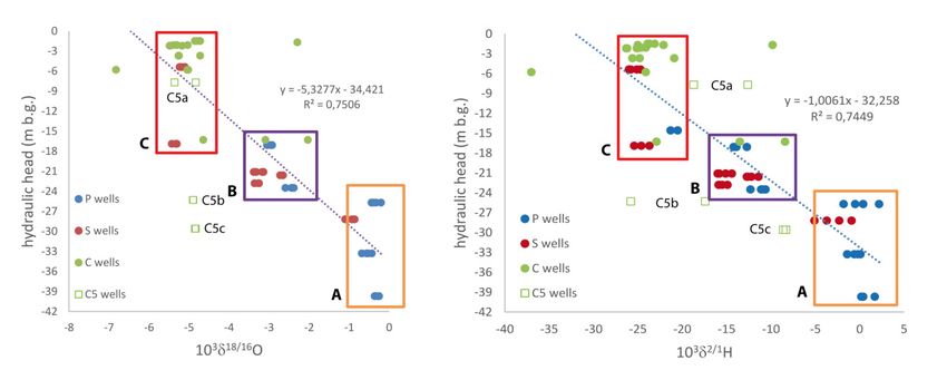
Appl. Sci. 2020, 10, 8177                                                                         9 of 24

      The analytical prediction uncertainty was ±0.1% for δ18 O, ±1% for δ2 H, and ±0.5 T.U. for 3 H.

3.3. Microbiological Analyses: 16S Ribosomal RNA Gene Next Generation Sequencing (NGS)
      The microbiological survey was carried out in December 2019 on samples from the multilevel
piezometers C5a-c to refine knowledge about the bacterial community in the groundwater. This survey
was limited to cluster C5 because it was carried out to investigate the possible influence of microbial
activity on some isotopic features, with emphasis on deuterium content in the C5 groundwater.
      Water samples (1 L) were filtered through sterile mixed esters of cellulose filters (S-PakTM
membrane filters, 47 mm diameter, 0.22 µm pore size, Millipore Corporation, Billerica, MA, USA)
within 24 h after collection. Bacterial DNA extraction from the sample filters was performed using the
commercial kit FastDNA SPIN Kit for soil and the FastPrep® Instrument. Once the DNA extraction was
complete, the quantity and integrity of the DNA were evaluated by electrophoresis in 0.8% agarose gel,
containing 1 µg/mL of Gel-RedTM , in the running buffer TAE 1X (40 mM tris base, 20 mM acetic acid,
and 1 mM EDTA pH 8), and amplification reactions were performed by polymerase chain reaction (PCR).
The 16S rDNA profiles of the bacterial communities in the samples were obtained by NGS technologies
at the Genprobio Srl Laboratory (Parma, Italy). Partial 16S rRNA gene sequences were obtained from
the extracted DNA by PCR, using the primer pair Probio_Uni and/Probio_Rev, which targets the
V3 region of the bacterial 16S rRNA gene sequence [48], and the primer pair ArchV46 for archaeal
16S rRNA [49]. Amplifications were carried out using a Verity Thermocycler (Applied Biosystems
Foster City, CA, USA), and PCR products were purified by the magnetic purification using Agencourt
AMPure XP DNA Purification Beads (Beckman Coulter Genomics GmbH, Bernried, Germany) to
remove primer dimers. Amplicon checks were carried out as previously described [48]. Sequencing
was performed using an Illumina MiSeq sequencer with MiSeq Reagent Kit v3 chemicals. The fastq
files were processed using a custom script based on the QIIME software suite [50]. Quality control
retained sequences with lengths between 140 and 400 bp and mean sequence quality scores >20,
whereas sequences with homopolymers >7 bp and mismatched primers were omitted. To calculate
downstream diversity measures, operational taxonomic units (OTUs) were defined at 100% sequence
homology using DADA2 [51]; OTUs not encompassing at least two sequences of the same sample were
removed. All reads were classified to the lowest possible taxonomic rank using QIIME2 [50,52] and a
reference dataset from the SILVA database v132 [53]

4. Results and Discussion

4.1. Hydrogeological Features
     The hydraulic head fluctuated over the year from tens of centimeters to several meters, depending
on the area. A recession period was typically observed from late spring to early autumn, whereas
recharge was typically observed from early autumn to spring (Figure 7). Overall, the head measurements
suggested relatively slow recharge, according to the low bulk permeability of the studied system,
which does not favor rapid percolation of fresh-infiltration waters within the unsaturated zone and
corresponding short-term fluctuations of the groundwater surface. The low bulk permeability of the
studied medium is in agreement with the findings of other authors who performed pumping tests in
similar Messinian successions in Southern Italy (transmissivity on the order of 10−5 m2 /s; [14,16]).
     Based on the hydrogeological monitoring and survey results, the general groundwater flow
scheme in the area was reconstructed (Figure 8a). The groundwater flows from the highlands towards
the topographic depressions, with the hydraulic gradient ranging from ~30% to ~3%, respectively.
The lowest head was consistently measured within the eastern depression, in the area of piezometers
S3–S5, and no significant modifications of the groundwater flow net were observed over time,
during the observation period. Therefore, all the piezometers used to analyse the isotopic signature
from a hydrogeological perspective maintained the same hydraulic relationships throughout the year.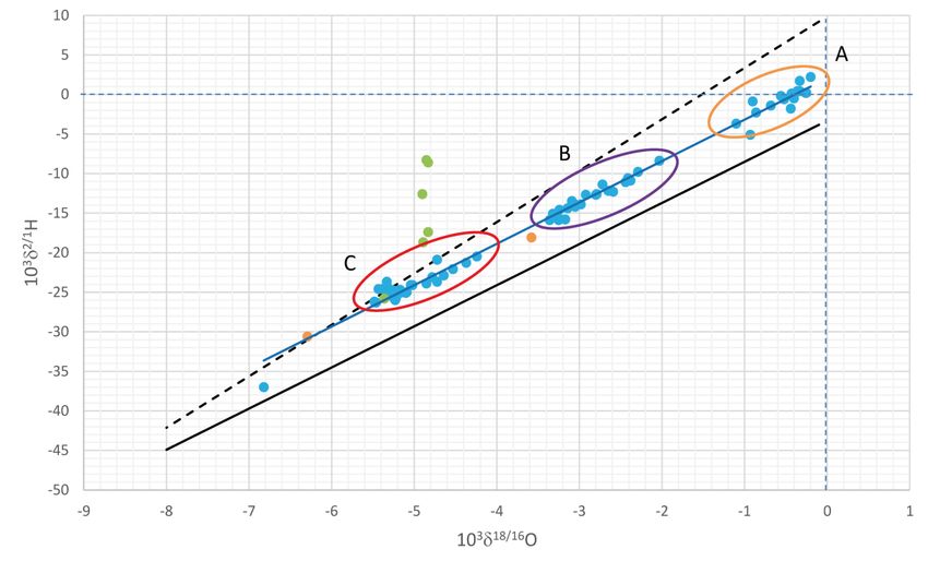
Appl. Sci. 2020, 10, 8177                                                                                             10 of 24

This finding implies that all the results discussed in the isotopic section were not influenced at all by
modifications
Appl. Sci. 2020, 10,of the PEER
                     x FOR groundwater
                                REVIEW flow field.                                                10 of 24

      Figure 7. Hydraulic
                   Hydraulic head head variations
                                       variations in
                                                  in piezometer
                                                     piezometer S4
                                                                S4 (blue
                                                                   (blue dots) vs. daily
                                                                                   daily rainfall
                                                                                         rainfall (light
                                                                                                  (light blue
                                                                                                         blue bars).
                                                                                                               bars).
      Dates   are2020,
       Appl. Sci.  given       day/month/year
                       10, xinFOR
                               day/month/year   format.
                                  PEER REVIEW format.                                                         11 of 24

     Based on the hydrogeological monitoring and survey results, the general groundwater flow
scheme in the area was reconstructed (Figure 8a). The groundwater flows from the highlands towards
the topographic depressions, with the hydraulic gradient ranging from ∼30% to ∼3%, respectively.
The lowest head was consistently measured within the eastern depression, in the area of piezometers
S3–S5, and no significant modifications of the groundwater flow net were observed over time, during
the observation period. Therefore, all the piezometers used to analyse the isotopic signature from a
hydrogeological perspective maintained the same hydraulic relationships throughout the year. This
finding implies that all the results discussed in the isotopic section were not influenced at all by
modifications of the groundwater flow field.
     In light of the sedimentological features and common lateral inhomogeneity of the evaporitic
layers (Figure 3), simple expected hydrogeological and hydrochemical behaviors are difficult to
define for the sequence that outcrops at the key site of the C5 cluster. In fact, the RNZ layer, which
overlies the second cycle gypsum evaporitic bodies, is composed of a very chaotic sandy-clayey
deposits, including dispersed gypsum blocks; consequently, a moderate primary permeability is
expected, despite the high clay content. In addition, the first cycle evaporitic layers and the basal
Tortonian clays are expected to be characterised by high and low permeability, respectively, whereas
the role of the second cycle gypsum bodies, which are to be classified as permeable on a small scale,
could be strongly controlled, overall, by the lack of lateral continuity, resulting in very slow hydraulic
circuits.

              8. (a)8.Hydrogeological
      FigureFigure                      map
                       (a) Hydrogeological mapofofthe
                                                    thestudy
                                                         studyarea
                                                               area (December    2019);(b)(b)
                                                                    (December 2019);          relationship
                                                                                            relationship    between
                                                                                                         between the the
      hydraulic  headhead
            hydraulic    and and
                             the the
                                 depth  below
                                     depth     ground
                                           below  groundobserved
                                                            observed at
                                                                     at the C5
                                                                            C5cluster.
                                                                               cluster.

            As observed at the C5 cluster, the hydraulic head significantly varied with depth (Figure 8b). In
       greater detail, it progressively decreased with increasing depth, showing the highest head in the
       shallow system and the lowest one into the piezometer C5c, screened within a gypsum horizon. The
       head zonation was confirmed based on the seasonal groundwater oscillation, with coherent hydraulic
Appl. Sci. 2020, 10, 8177 11 of 24
In light of the sedimentological features and common lateral inhomogeneity of the evaporitic
layers (Figure 3), simple expected hydrogeological and hydrochemical behaviors are difficult to define
for the sequence that outcrops at the key site of the C5 cluster. In fact, the RNZ layer, which overlies
the second cycle gypsum evaporitic bodies, is composed of a very chaotic sandy-clayey deposits,
including dispersed gypsum blocks; consequently, a moderate primary permeability is expected,
despite the high clay content. In addition, the first cycle evaporitic layers and the basal Tortonian clays
are expected to be characterised by high and low permeability, respectively, whereas the role of the
second cycle gypsum bodies, which are to be classified as permeable on a small scale, could be strongly
controlled, overall, by the lack of lateral continuity, resulting in very slow hydraulic circuits.
As observed at the C5 cluster, the hydraulic head significantly varied with depth (Figure 8b).
In greater detail, it progressively decreased with increasing depth, showing the highest head in the
shallow system and the lowest one into the piezometer C5c, screened within a gypsum horizon.
The head zonation was confirmed based on the seasonal groundwater oscillation, with coherent
hydraulic heads shifts, consistent with the fact that the analysed medium behaves as a continuum
at the observation scale of the present study. This finding is also in agreement with the expectation
for saturated heterogeneous media comparable with the studied media. In these media, if a lower
geological formation has a higher hydraulic conductivity than the overlying layer, it acts as the major
conduit of flow [54]. The highest head in C5a was compatible with the phreatic surface reconstructed
within the whole studied area, the morphology of which reflects the local topography (Figure 8a),
as expected in such low-permeability systems.
4.2. Hydrogen and Oxygen Isotopes
Waters from all the piezometers P, S, and C shown in Figure 8a were sampled for δ18/16 O and δ2/1 H
measurements. The values of the analysed samples ranged from −37.0% to 2.2% for hydrogen and
from −6.8% to −0.2% for oxygen. Three different main groups could be identified: Group A (P1, P2,
P3 and S6) exhibited the highest δ2/1 H and δ18/16 O values in the intervals from −5.2% to 2.2% and from
−1.1% to −0.2%, respectively; Group B (wells P4, P5, P7, S1, S2, S3, and S5) had intermediate values in
the ranges from −16.0% to −10.6% for δ2/1 H, and from −3.4% to −2.4% for δ18/16 O; Group C (wells
P6, S4, C1, C3, and C4) included the lowest δ2/1 H and δ18/16 O values, from −26.3% to −20.5% and from
−5.5% to −4.2%, respectively (Figure 9). For all the piezometers, the isotopic values did not change
in the different sampling periods, with the exception of C2, C6 and C7, which showed swings across
groups B and C (C2: δ2/1 H = −22.9% to −8.4% and δ18/16 O = −4.6% to −2.0%; C6: δ2/1 H = −25.0%
to −9.8% and δ18/16 O = −5.1% to −2.3%; C7: δ2/1 H = −37.0% to −24.1% and δ18/16 O = −6.8% to
−5.0%). The groundwater samples collected in the C5 cluster exhibited a very unusual distribution.
In the δ2/1 H vs. δ18/16 O diagram shown in Figure 9, their δ2/1 H values are distributed vertically ranging
from about −23.5 to −8.5% (see below for more details).
Regarding the affinity of the sampled groundwaters, all groups plotted along the local meteoric
water lines available in the scientific literature [55–62], being consistent with those of rainwater collected
in the study area during the observation period; this finding suggests a meteoric origin for the analysed
waters (Figure 9), with no influence of ascending fluids coming from deep reservoirs, the isotopic
signature of which are notably different from those of actual precipitations [35].
The δ2/1 H and δ18/16 O values are correlated with the depth of the phreatic surface (Figure 10).
The piezometers showing the deepest phreatic surface (>25 m below ground, m b.g.) belong to Group
A; Group B includes phreatic surface at 23.5 to 17 m b.g.; Group C may be divided into two different
sub-groups: one with a depth lower than 6 m b.g., and another one with a level ranging from 14.5 to
17 m b.g. Wells C5b and C5c are excluded because their water levels are representative of the hydraulic
head measured at different depths below ground and is not referable to the local phreatic surface
(coinciding with the water level measured in C5a).Regarding the affinity of the sampled groundwaters, all groups plotted along the local meteoric
water lines available in the scientific literature [55–62], being consistent with those of rainwater
collected in the study area during the observation period; this finding suggests a meteoric origin for
the analysed waters (Figure 9), with no influence of ascending fluids coming from deep reservoirs,
Appl.isotopic
the Sci. 2020,signature
10, 8177 of which are notably different from those of actual precipitations [35]. 12 of 24
Figure 9. Relations between 103 δ2/1 H and 103 δ18/16 O for the investigated waters (blue dots). Groups A,
Figure 9. Relations between 103 δ2/1H and 103 δ18/16O for the investigated waters (blue dots). Groups
B, and C are encircled in ochre, purple, and red, respectively. The green dots represent C5a-c waters.
A, B, and C are encircled in ochre, purple, and red, respectively. The green dots represent C5a-c
The orange dots indicate the rainwater samples analysed during this study. The solid black and the
Appl.waters.
Sci. 2020,
The10, orange
x FOR PEER
dotsREVIEW
indicate the rainwater samples analysed during this study. The solid black13 of 24
dashed black lines are representative of the meteoric water lines available in Sicily (with emphasis
and theand
on [62] dashed black lines areThe
[56], respectively). representative oflinear
blue line is the the meteoric water
interpolation oflines available inisotopic
the groundwater Sicily (with
data.
emphasis on [62] and [56], respectively). The blue line is the linear interpolation of the groundwater
isotopic data.
The δ2/1H and δ18/16O values are correlated with the depth of the phreatic surface (Figure 10). The
piezometers showing the deepest phreatic surface (>25 m below ground, m b.g.) belong to Group A;
Group B includes phreatic surface at 23.5 to 17 m b.g.; Group C may be divided into two different
sub-groups: one with a depth lower than 6 m b.g., and another one with a level ranging from 14.5 to
17 m b.g. Wells C5b and C5c are excluded because their water levels are representative of the
hydraulic head measured at different depths below ground and is not referable to the local phreatic
surface (coinciding with the water level measured in C5a).
Figure 10. Relations between the hydraulic head and 103 δ2/1 H and 103 δ18/16 O for the investigated
waters.
Figure Waters from the
10. Relations C5 cluster
between the are not considered
hydraulic head andin 10
the3 regressions.
δ2/1H and 103 δ18/16O for the investigated
waters. Waters from the C5 cluster are not considered in the regressions.
Regarding tritium, the rainwater samples had high 3 H contents (6.2 to 10.8 T.U.), whereas the
groundwater
Regarding samples showed
tritium, a wide range
the rainwater of tritium
samples had high contents (Figure 11).
3H contents (6.2 Taking
to 10.8 into
T.U.),consideration
whereas the
the tritium content detected in local rainwater during the observation period,
groundwater samples showed a wide range of tritium contents (Figure 11). Taking into consideration as well as data already
available for Southern Italy (e.g., 4.5 T.U. in [63]; 5.0 T.U. in [16]), three groundwater
the tritium content detected in local rainwater during the observation period, as well as data already types have been
detected
availableatfortheSouthern
study site: (i)(e.g.,
Italy groundwater
4.5 T.U. inrelated to T.U.
[63]; 5.0 rapidinand/or shortgroundwater
[16]), three pathways within typesthe aquifer
have been
system
detected at the study site: (i) groundwater related to rapid and/or short pathways within the higher
(4 to 10 T.U.), (ii) groundwater related to longer and/or prolonged pathways, with aquifer
mean-residence
system (4 to 10 timesT.U.), (10higher
T.U.,
corresponding
mean-residencetotimes at least(10 T.U.,
findings in other sites in Italy [64], is linked mainly to rainwater precipitated
corresponding to at least 300 T.U. at the beginning of 1960s), the recharge of which, according to during the 1950s and
1960s, when
findings tritium
in other was
sites inspiked in the
Italy [64], atmosphere
is linked mainlybytonuclear weapons
rainwater testingduring
precipitated [65], reaching
the 1950supand
to
several thousand T.U. in rainwater (e.g., [66]).
1960s, when tritium was spiked in the atmosphere by nuclear weapons testing [65], reaching up to
several thousand T.U. in rainwater (e.g., [66]).
Figure 11 reports the relation between 103 δ2/1H and T.U. The evident and strongly significant
correlation (R2 = 0.998, and null hypothesis Ho(slope=0) < 0.001) for the data of the C5 cluster is an
intriguing problem. Different explanations for this interesting correlation are proposed below.1960s, when tritium was spiked in the atmosphere by nuclear weapons testing [65], reaching up to
several thousand T.U. in rainwater (e.g., [66]).
Figure 11 reports the relation between 103 δ2/1H and T.U. The evident and strongly significant
correlation (R2 = 0.998, and null hypothesis Ho(slope=0) < 0.001) for the data of the C5 cluster is an
Appl. Sci. 2020,problem.
intriguing 10, 8177 Different explanations for this interesting correlation are proposed below.
13 of 24
Figure 11. Relation between 103 δ2/1 H and T.U. in the investigated waters. Waters from the C5 wells
exhibit a significant 103 δ2/1 H vs. T.U. correlation.
Figure 11 reports the relation between 103 δ2/1 H and T.U. The evident and strongly significant
correlation (R2 = 0.998, and null hypothesis Ho(slope=0) < 0.001) for the data of the C5 cluster is an
intriguing problem. Different explanations for this interesting correlation are proposed below.
4.3. Next-Generation Sequencing Results
The microbial community of groundwater sampled in the C5 cluster was analysed to explore the
possible influence of microbial activity (H2 S and CH4 production) on the unusual deuterium content
detected in C5-waters. The 16S rRNA gene sequences of both bacteria and archaea identified in this
study have been deposited in the National Center for Biotechnology Information (NCBI) Sequence
Read Archive under the accession number PRJNA631131. Based on analysis of the sequences obtained
from the C5 cluster with NGS technologies, the broad diversity of the microbial community in terms of
relative abundance of bacterial genera has been highlighted (Table 1).
Regarding the main aim of the present study, the analyses showed a bacterial community
characterised by aerobic and anaerobic/facultative anaerobic genera. Many of these genera are
common in bacterial communities found in salty groundwater and marine environments. Halophilic
bacteria can be considered moderate halophiles or extreme halophiles based on the concentration of
salts present in water and soils (e.g., Alcanivorax [67] and Marinomonas [68] in Table 2); in contrast,
halotolerant bacteria, despite growing better without NaCl, can tolerate high quantities of salt [69]
(e.g., Arcobacter [70] and Pseudomonas [71] in Table 2). In addition, some of the bacterial genera can
exploit sulfate reduction (Desulfatiglans [72], Desulfovibrio [73], and Shewanella [74] in Table 2) as a
metabolic pathway. Sulfate reduction is a form of anaerobic respiration, typical of sulfate-reducing
bacteria (SRB) or sulfur-reducing bacteria, and as such typically occurs in anoxic environments and
leads to the production of hydrogen sulfide (H2 S); however, some studies have found that this process
can also occur in the presence of oxygen [71,75].Appl. Sci. 2020, 10, 8177 14 of 24
Table 1. Bacterial genera detected in groundwater samples collected in C5a-c (relative abundance >0.7%).
Taxonomy C5a C5b C5c
Aeromonas 2.13% 0.14% 0.07%
Alcanivorax 0.72% 0.95% 0.46%
Arcobacter 1.67% 0.13% 1.12%
Candidatus Nitrotoga 0.00% 0.74% 0.33%
Idiomarina 0.20% 0.08% 0.84%
Limnobacter 1.57% 0.00% 2.18%
Magnetospira 0.18% 0.73% 0.31%
Marinobacter 0.11% 0.36% 0.98%
Marinobacterium 0.05% 0.00% 1.29%
Marinomonas 1.23% 0.00% 0.30%
Nitrosomonas 0.00% 3.43% 0.64%
Nitrospina 0.06% 1.91% 0.36%
Oceanobacter 0.12% 3.82% 0.46%
Parvibaculum 0.28% 0.42% 1.19%
Pseudohongiella 0.85% 2.72% 0.85%
Pseudomonas 58.95% 52.18% 47.22%
Rehaibacterium 0.17% 7.38% 2.29%
Rheinheimera 2.50% 0.00% 0.55%
Roseovarius 0.04% 0.78% 0.30%
Shewanella 7.39% 0.07% 0.72%
Sphingobium 1.60% 0.00% 1.06%
Sphingomonas 0.92% 0.11% 0.44%
Thiobacillus 0.00% 0.19% 1.34%
Vibrio 0.00% 0.03% 5.77%
Table 2. Metabolic characteristics of selected bacterial genera detected in groundwater samples collected
in C5a–c.
Facultative Facultative Halophilic/ Sulfate
Taxonomy Aerobic Anaerobic
Aerobic Anaerobic Halotolerant Reduction
Alcanivorax + +
Arcobacter + + +
Desulfatiglans + + + +
Desulfovibrio + + + +
Marinobacter + +
Marinomonas + +
Oceanobacter + +
Pseudomonas + + +
Shewanella + + + +
Vibrio + + +
Regarding the archaeal component, the most abundant genus found in the analysed groundwater
samples (C5a-c) was Candidatus Nitrosopumilus [76] (Table 3). This genus is typically found in marine
environments where ammonia can be oxidised to nitrite. Moreover, halophilic genera were identified,
such as Halococcus [77] (Table 3), a genus capable of living in the presence of very high concentrations of
NaCl (up to 4.5 M NaCl). Methanogenic genera, such as Methanobacterium [78], Methanimicrococcus [79],
and Methanolobus [80] were also found (Table 3). Methanogenesis is a strictly anaerobic metabolic
pathway that leads to the formation of methane, and s performed only by methanogenic archaea.
Thus, the biomolecular investigations demonstrated that C5-groundwaters are characterised
by bacterial (Desulfatiglans, Desulfovibrio, and Shewanella) and archaeal (Methanobacterium,
Methanimicrococcus, and Methanolobus) genera able to produce H2 S and CH4 , respectively, therefore
suggesting that microbial activity is a factor of utmost importance to be taken into consideration when
analysing the isotopic signature of local groundwater.Appl. Sci. 2020, 10, 8177 15 of 24
Table 3. Metabolic characteristics of selected archaeal genera detected in groundwater samples collected
in C5a-c.
Halophilic/ Sulfate Ammonia
Taxonomy Aerobic Anaerobic Methanogenesis
Halotolerant Reduction Oxidizing
Candidatus Nitrocosmicus + + +
Candidatus
+ + +
Nitrosoarchaeum
Candidatus
+ + +
Nitrosopumilus
Halococcus + +
Halogranum + + +
Methanimicrococcus + + +
Methanobacterium + + +
Methanolobus + + +
Methanothermobacter + + + +
5. Hydrogeological Model
Geological, hydrogeological, isotopic and biomolecular investigations allowed characterisation of
the hydrogeological functioning of the studied heterogeneous low-permeability system, as well as
refinement of knowledge about the residence time of groundwater within such systems.
As expected, taking into consideration previous studies in similar geologic settings [16], the studied
system is characterised by vertical and discontinuous heterogeneity [81], caused by various factors
such as (i) the coexistence of different geological formations, (ii) their folded regular sequence, and (iii)
the fractured (karstified) evaporitic intrastrata/lenses that locally increase the bulk permeability of the
low-permeability system. In contrast with other heterogeneous systems, no fault zones influence fluid
flow, neither enhancing [82–84] nor partially or totally impeding it [85–87].
When the hydrogeological system is analysed at the basin scale, the whole system can be depicted
as a continuous medium, and the groundwater flow net is a smoothed replica of the local topography.
Groundwater flow clearly occurs from the highlands towards the topographic depressions.
The vertical heterogeneity of the system causes the hydraulic head to significantly vary with depth.
Close to the C5a-c cluster, the hydraulic head decreases with increasing depth, with the lowest head into
the karstified gypsum layer (C5c). This head distribution agrees with that observed by Petrella et al. [16]
within the peninsular Southern Italy, where the more transmissive and discontinuous localised media
drain the surrounding lower permeability rocks up-gradient (lower hydraulic head), whereas they
are characterised by higher head down-gradient and feed the surrounding lower permeability media
(Figure 12). Because the vertical heterogeneity is discontinuous, it is unable to provide a continuous
solution within the stratigraphic sequence over an extended area. Therefore, in contrast with other
systems characterised by vertical heterogeneity, from the hydraulic point of view [64,88–90], no perched
aquifers overlie deeper ones, and a unique saturated zone can be assumed.
Overall, the heterogeneous distribution of lower- and higher-permeability rocks within the studied
system, as well as the groundwater flow field described above (Figure 12), cause the mean residence
time of groundwater to not necessarily be in agreement with the only groundwater flow net depicted in
Figure 8. The coexistence of slower and faster flow velocities and the existence of vertical flow, cause a
sort of patchwork distribution of tritium content, with higher levels detected at depths extending
into evaporitic interstrata/lenses, linked mainly to rainwater precipitated during the 1950s and 1960s,
when tritium was spiked in the atmosphere by nuclear weapons testing.You can also read