Living Shorelines for the Vancouver Region - UBC Sustainability
←
→
Page content transcription
If your browser does not render page correctly, please read the page content below

Living Shorelines for the Vancouver Region
Ideas for restoring coastal habitats and adapting to sea level rise
Prepared by Natasha Jackson-Drouin, UBC Sustainability Scholar, 2020
Prepared for Sarah Primeau, Landscape Architect & Ecologist, Space2place Design Inc.
March 2021
Sustainability Scholars Disclaimer
 This report was produced as part of the UBC Sustainability Scholars Program, a partnership
 between the University of British Columbia and various local governments and organizations
 in support of providing graduate students with opportunities to do applied research on
 projects that advance sustainability across the region.

 This project was conducted under the mentorship of Space2place Design Inc. staff. The
 opinions and recommendations in this report and any errors are those of the author and do
 not necessarily reflect the views of Space2place Design Inc. or the University of British
 Columbia.

Acknowledgements
A big thank you to all of those who gave their time to contribute to this project and to those who
shared their images included here. I want to extend a special thank you to Sarah Primeau for her
guidance throughout this project. Finally, I would like to thank my feathered office mates that
always had to add their two-sense.

Cover art “Lo-fi” watercolor on paper by Natasha Jackson-Drouin
Contents
Executive Summary _________________________________________________________________ 2
Introduction_______________________________________________________________________ 4
Background _______________________________________________________________________ 4
  Sea Level Rise and Coastal Habitats ___________________________________________________ 4
  Living Shorelines Concept __________________________________________________________ 5
  General Site Descriptions __________________________________________________________ 5
Methodology ______________________________________________________________________ 6
  Literature Review_________________________________________________________________ 6
  Interviews with Living Shoreline Experts _______________________________________________ 6
  Design Ideas ____________________________________________________________________ 6
Research Findings __________________________________________________________________ 6
  Living Shoreline Precedent Projects __________________________________________________ 6
  Interviews and Meetings __________________________________________________________ 29
  Sturgeon Bank: Biophysical Conditions and Selected Focal Species _________________________ 29
  False Creek: Biophysical Conditions and Selected Focal Species ____________________________ 36
  Design Ideas ___________________________________________________________________ 41
Conclusions ______________________________________________________________________ 45
  Living Shorelines and Restoration ___________________________________________________ 45
  Dynamic Systems ________________________________________________________________ 45
  Other Considerations ____________________________________________________________ 45
  Reciprocity _____________________________________________________________________ 46
References _______________________________________________________________________ 47
List of Figures
Where required - images are used with permission
Figure 1. New Brighton Salt Marsh shortly after construction (Google Earth) ____________________ 7
Figure 2. Restored salt marsh at New Brighton Park ________________________________________ 8
Figure 3. The Habitat Skirt at the Vancouver Convention Centre ______________________________ 9
Figure 4. Royston Barrier Islands at centre (Google Earth) __________________________________ 10
Figure 5. Before shoreline work done by Coastal Geologic Service at Ala spit ___________________ 11
Figure 6. After shoreline work done by Coastal Geologic Service at Ala spit _____________________ 11
Figure 7. Ala Spit (Google Earth) ______________________________________________________ 12
Figure 8. Kilisut Harbour with new bridge crossing over the restored tidal channel (Google Earth) ___ 12
Figure 9. Leque Island (Google Earth) __________________________________________________ 13
Figure 10. Underneath the cantilevered walkway at Elliott Bay ______________________________ 14
Figure 11. Marine mattresses and benches exposed at low tide at Elliott Bay Seawall _____________ 15
Figure 12. Habitat Beach next to Alaskan Way (Google Earth) _______________________________ 16
Figure 13. Seal Beach National Wildlife Refuge (Google Earth) _______________________________ 17
Figure 14. Salt marsh set inland from rip rap shoreline at Hunter’s Point South Park ______________ 18
Figure 15. Tide deck at Pier 26 below two overhanging walkways ____________________________ 19
Figure 16. Leonardtown Wharf (Google Earth) ___________________________________________ 20
Figure 17. Overview of the Floating Wetland in Baltimore Harbour ___________________________ 21
Figure 18. The Floating Wetland in Baltimore Harbour attached to two pilings __________________ 22
Figure 19. Wetland plants growing in a polyethylene/plastic matrix ___________________________ 22
Figure 20. Living shoreline breakwaters in Hancock County, MS _____________________________ 23
Figure 21. Straight on view of living shoreline breakwaters in Hancock County, MS _______________ 23
Figure 22. An example of a salt marsh cell being constructed in Heron Bay, Hancock County, MS ____ 24
Figure 23. Recycled Park in Rotterdam, Netherlands. Islands and floating wetlands (Google Earth) __ 25
Figure 24. Recycled park’s floating wetlands _____________________________________________ 25
Figure 25. Recycled park with floating wetlands and seating area ____________________________ 26
Figure 26. Carss Bush Park (Google Earth) _______________________________________________ 27
Figure 27. Living Seawall tiles installed on a seawall in Sydney, AUS ___________________________ 28
Figure 28. Closer look at the Living Seawall tiles __________________________________________ 28
Figure 29. Regional wind patterns and surface currents occurring at Iona Island _________________ 31
Figure 30. Wind data from Vancouver International Airport ________________________________ 32
Figure 31. Surface currents during tidal changes in Burrard Inlet that influence False Creek ________ 37
Figure 32. Wind data from western False Creek __________________________________________ 38
List of Tables
Table 1. Summary of details - Surf Smelt and Pacific Sand Lance spawning habitats _______________ 35
Living Shorelines for the Vancouver Region | Jackson-Drouin

Executive Summary
This report was created as part of the Fall 2020 UBC Sustainability Scholars Program. This
research project was done to inform living shoreline design options for the Vancouver region,
specifically for two study areas within which Space2place Design is currently working: north
Sturgeon Bank, and False Creek. A range of completed living shoreline projects were researched
and selected as precedents to study further. An in-depth literature review was undertaken to
identify important considerations for each study area. Interviews with experts and precedent
research furthered the overall understanding of living shorelines. This culminated into a
collection of examples of precedent work, context information for the sites, recommendations
for focal species and a collection of design ideas that align with a living shoreline approach. The
author’s working definition of a living shoreline approach is as follows: using a deeper
understanding of the natural shoreline and of the natural processes that occur there, to design a
more resilient and sustainable shoreline. It is moving away from a hard armoring of the shore to
designing soft or green alternatives that are harmonious with the surrounding ecology and
overarching coastal system.

Research Findings
Precedent projects (18) were selected to represent a range of built living shoreline project types.

New Brighton Salt Marsh, Vancouver, B.C.              Tide Deck at Pier 26, New York City, NY
Vancouver Convention Centre Habitat Skirt,            Leonardtown Wharf, Leonardtown, MD
Vancouver, B.C.                                       Floating Wetland, Baltimore, MD
Royston Barrier Islands, Courtenay, B.C.              Hancock County Living Shoreline, Hancock
Ala Spit, Whidbey Island, WA                          County, MS
Kilisut Harbour, Port Townsend, WA                    Deer Island, Biloxi, MS
Leque Island, Stanwood, WA                            Recycled Park floating wetlands, Rotterdam,
Elliott Bay Seawall, Seattle, WA                      Netherlands
Elliott Bay Habitat Beach, Seattle, WA                Carss Bush Park, Kogarah Bay, Sydney,
Seal Beach National Wildlife Reserve,                 Australia
Northwest Orange County, CA                           Living Seawall Tiles, Sydney, Australia
Hunter’s Point South Park, New York City, NY

Interviews and meetings (9) with living shoreline and other experts provided insight on
constructed living shoreline projects and informed design ideas.

                                                                                                         2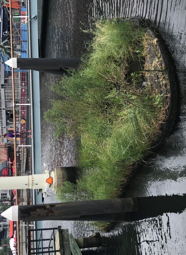
Living Shorelines for the Vancouver Region | Jackson-Drouin

Biophysical Conditions such as tides, currents, wind, and wave conditions at each study site are
included in this report. Sediment transport was a focus for Sturgeon Bank and water quality was
a focus for False Creek. Conditions on the northern portion of Sturgeon Bank appear to be both
erosional and accretional (Page, 2011). The main concern for water quality in False Creek is
Escherichia coli concentrations. It appears that the highest concentrations of E. coli occur along
the shores of the eastern portion of the inlet (Cummings, 2016).

Focal Species suggestions for Sturgeon Bank are sandpipers (Western Sandpipers and Pacific
Dunlin), forage fish (Pacific Sand Lance and Surf Smelt) and juvenile chinook For False Creek they
are herring, mussels, and cormorants. Details about habitat requirements are also included.

In terms of living shoreline design, the design ideas for Sturgeon bank consist of a focus on
restoring tidal marshes and sediment augmentation as a tool to help the habitat adapt to sea
level rise. Re-establishing habitat connectivity through the removal of built structures such as
dikes and jetties will also help restore healthy shoreline processes to the area. Using breakwaters
that encourage passive accretion of sediment would help establish tidal marsh habitats and
combat erosion. Additional approaches would use breakwaters for habitat and include the
incorporation of a habitat bump on the seaward side of a breakwater or, where appropriate, the
use of the barrier island technique, where the island helps reduce erosion and can itself become
a place for new tidal marsh to develop.

The design ideas for False Creek comprise of multiple habitat types including rocky Intertidal,
eelgrass meadow and tidal marsh. Rocky intertidal habitat would be achievable in False Creek,
and it could support mussels, rockweed, and herring. A constructed tidal marsh would provide
additional habitat diversity, and eelgrass meadows in the subtidal zone would further contribute
to habitat values. False Creek has the opportunity to increase habitat complexity through
engineered habitat structures and has the potential to reuse existing structures to do so. Finally,
the potential for a floating wetland to further increase tidal habitat in False Creek is suggested.

Living shoreline design and habitat restoration share many similarities, with both aiming to
enhance the ecological health of shorelines. Many of the precedents explored here focus on
shoreline restoration as a form of living shoreline design. It is also important to consider the
larger system of which these dynamic shorelines belong and to have a thorough understanding of
the broader system to ensure success of the design. Finally, additional factors to consider when
designing these sites are land use needs, infrastructure, public input, flood protection
requirements, and more. The social-ecological system in which these shorelines are found do not
occur in isolation, with many stakeholders and variables involved. This should all be taken into
consideration when reviewing and applying this work.

                                                                                                         3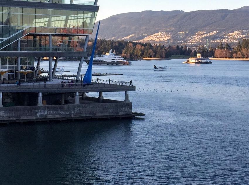
Living Shorelines for the Vancouver Region | Jackson-Drouin

Introduction
This project set out to advance understanding of living shoreline design and nature-based flood
protection principles to advance local design knowledge of living shorelines, and to identify
successful precedents to draw from for this type of work. The project also sought to help inform
living shoreline design ideas for two of space2place’s ongoing waterfront design projects - one in
north Sturgeon Bank with a focus on Iona Island and the other along the east shores of False
Creek.

Conventional methods of shoreline design and alteration have relied heavily on hard edges using
“grey” infrastructure. This includes a reliance on seawalls, dikes, conventional breakwaters, and
other shoreline controlling strategies, specifically to control erosion, establish deep water for
access and to increase functionality for human use. This has left coastal regions with shorelines
that lack ecological functions. In addition, considerations for sea level rise have brought
awareness to the importance of sustainable and adaptive shorelines. The Vancouver region has,
for upwards of 150 years, followed the conventional method of hardening shorelines. More
sustainable approaches to shoreline design have gained popularity and have become more
feasible and favorable options. Many municipalities in the Lower Mainland are starting to
understand the threat of sea level rise and have begun implementing strategies to adapt. Living
shoreline design and nature-based flood protection are powerful frameworks and tools that can
be used to align shoreline design with a resilient perspective of shorelines.

It is important to note that this report does not address all of the considerations that ultimately
contribute to project design, such as historical conditions, flood protection requirements, and
shoreline programming, among other things. This should be taken into consideration when
interpreting this work.

Background
Sea Level Rise and Coastal Habitats
The Vancouver region’s shorelines are being affected by climate change through sea level rise,
increased storms, more frequent flooding events, increased water temperatures and pH changes.
Sea level rise projections for this region recommend planning for +1.0 m sea level rise by 2100
and +2.0m by 2200 (Kerr Wood Leidal Associates Ltd., 2011). One impact of sea level rise on
shorelines is the phenomenon of “coastal squeeze” – where a reduction or disappearance of
coastal habitat occurs when landward migration of habitats is not possible.

                                                                                                         4
Living Shorelines for the Vancouver Region | Jackson-Drouin

Living Shorelines Concept
The term “living shoreline” first gained popularity on the East and Gulf coasts of the United
States and the approaches and strategies associated with living shoreline design are often rooted
in the geography and biology of those regions (P. Hummel, personal communication, January 21,
2021). For the purposes of this work, the living shoreline approach is synonymous with a nature-
based approach to shoreline design and flood protection. Living shoreline principles take a “win-
win” ecoengineering perspective (Simenstad, 2017) that prioritizes both functional design and
ecological function, making sure both societal and ecological needs are met.
Ali Canning, in her master’s thesis described living shorelines as designing or enhancing shoreline
habitats that naturally protect coasts, such as marshes, dunes and beaches, and utilizing these to
create a shoreline that is resilient, stable, and biologically diverse (Canning, 2017). The
techniques used under this multilayered approach can be found on a spectrum from “green” to
“grey”, where more and more built or hard material is used. Hybrid approaches, such as marsh
sill walls and breakwaters, are prevalent features in living shoreline precedents. Some of the
living shoreline approaches explored in this report include breakwaters, barrier islands, tidal
marsh restoration, and thin-layer sediment augmentation.
The author’s personal understanding developed throughout this work and resulted in the
following working definition of a living shoreline approach:
   A living shoreline approach to coastal design uses a deeper understanding of the natural
   shoreline and of the natural processes that occur there, to design a more resilient and
   sustainable shoreline. It is moving away from a hard armoring of the shore to designing soft or
   green alternatives that are harmonious with the surrounding ecology and overarching coastal
   system. This approach also recognizes the social and ecological significance of shorelines.

General Site Descriptions
Study Area 1: North Sturgeon Bank
Sturgeon Bank refers to the area of relatively shallow water immediately west of Lulu and Sea
Islands, between the North Arm and the Main Arm of the Fraser River. Iona Island is located at
the north end of Sturgeon Bank, north of Sea Island and the Vancouver International Airport.
Iona Island is connected to Sea Island by a causeway that cuts McDonald Slough off from the
waters of Sturgeon Bank. There are two jetties that extend offshore from Iona Island, one
northwest and the other southwest. The bank between these two jetties makes up the upper
portion of Sturgeon Bank and is locally referred to as the inter-jetty area.

Study Area 2: East False Creek
False Creek is a small inlet to the south of the peninsula of downtown Vancouver. The inlet and
former wetlands used to extend east to modern-day Clark Drive (Wernick, et al., 2012).

                                                                                                        5
Living Shorelines for the Vancouver Region | Jackson-Drouin

Throughout the 19th and 20th centuries, land reclamation was done to promote industrial
development and railway infrastructure.

Methodology
Literature Review
An initial search of available resources was done to build understanding of living shoreline design.
This review informed the working definition and interpretation of what living shoreline design is
and ultimately informed the design ideas that came from this work. A large part of the literature
review was an in-depth search for relevant and applicable living shoreline design precedents. A
comprehensive look at biophysical characteristics of each study area was done. Important
species and habitats at each site were investigated. This was done to further inform the design
ideas and to provide recommendations for focal species and habitats.

Interviews with Living Shoreline Experts
Interviews and meetings with living shoreline experts and others in the fields of landscape
architecture, geomorphology, coastal engineering, and wetland ecology were conducted to
provide insights on constructed living shoreline projects and further inform design ideas for the
study areas. Meeting summaries and full meeting notes are included in the internal version of
this report (Appendix A).

Design Ideas
Design ideas for the study areas were the culmination of all the above-mentioned research.
Visualizations of these ideas were produced and are included in the internal version of this report
(Appendix B & Appendix C).

Research Findings
Living Shoreline Precedent Projects
The following 18 precedent projects were selected to represent a range of constructed living
shoreline project types. Precedents for both study areas are included here, with local projects
appearing first. Precedents range from “green” to “gray” and vary in material, site considerations
and strategies.

                                                                                                         6
Living Shorelines for the Vancouver Region | Jackson-Drouin
New Brighton Salt Marsh Creation
LOCATION VANCOUVER, B.C.
Port of Vancouver, Vancouver Port Authority, Stewardship Centre of
LED BY
BC, Moffatt & Nichol, Golder, Hemmera
SETTING Urban, saltwater, tidal marsh
KEY DESIGN ELEMENTS Salt marsh creation, grading
APPROXIMATE SIZE 100 m x 100 m
This project built and established a salt marsh as part of the redevelopment of New Brighton
park. The salt marsh provides habitat for juvenile salmon, and also collects and receives treated
rainwater runoff from nearby Hastings park. In June 2017, the City of Vancouver reported that
juvenile chum and chinook salmon had been seen using the new salt marsh as they moved
through Burrard Inlet (City of Vancouver, 2017).
Figure 1. New Brighton Salt Marsh shortly after construction (Google Earth)
7Living Shorelines for the Vancouver Region | Jackson-Drouin
Photo credit: Nick Page, Raincoast Applied Ecology
Figure 2. Restored salt marsh at New Brighton Park (used with permission)
Vancouver Convention Centre Habitat Skirt
LOCATION VANCOUVER, BC
LED BY WorleyParsons
SETTING Urban, salt water, built habitat
KEY DESIGN ELEMENTS Habitat benches, precast concrete
APPROXIMATE SIZE 500 lineal meters
This first-of-its-kind habitat structure was installed in 2008 as part of the new Vancouver
Convention Centre. The “skirt” is built of precast concrete for ease of installation and includes a
series of habitat benches cascading from the edge of the wall. The “skirt” was designed as an
artificial reef structure meant to encourage species diversity and maximize habitat connectivity
(Leonard & Kullmann, 2010).
8Living Shorelines for the Vancouver Region | Jackson-Drouin
Photo credit: Sarah Primeau, Space2place Design Inc.
Figure 3. The Habitat Skirt at the Vancouver Convention Centre, visible at the water’s surface (used with permission)
Royston Barrier Islands
LOCATION COURTENAY, B.C.
LED BY Comox Valley Project Watershed Society (CVPWS)
SETTING saltwater, log dump, natural area
KEY DESIGN ELEMENTS Barrier Island technique
APPROXIMATE SIZE 500 m2
Expert Interview with Dan Bowen
The project was built to promote habitat connectivity between the subtidal eelgrass meadows
and the tidal salt marshes, with a primary focus on restoring tidal habitat for migrating juvenile
salmon (Sutherst, 2013). It was designed and constructed by CVPWS who developed the “barrier
island” technique for use in the local area. This project was a pilot and a prototype for future
work (D. Bowen, personal communication, December 29. 2020). CVPWS claims this was the first
time that the barrier island technique was used on the west coast of Canada.
9Living Shorelines for the Vancouver Region | Jackson-Drouin
Figure 4. Royston Barrier Islands at centre (Google Earth)
Ala Spit Restoration
LOCATION WHIDBEY ISLAND, WASHINGTON
LED BY Coastal Geologic Services
SETTING Saltwater, lagoon, rural
Beach nourishment, log placement, partial grown removal, bulkhead
KEY DESIGN ELEMENTS
removal
APPROXIMATE SIZE 600 m
Expert Interview with Jim Johannessen
The project consisted of a partial groin and bulkhead removal and the placement of large woody
debris as well as beach nourishment. The restoration was in response to a great concern of
erosion of the spit. An in-depth understanding of the coastal processes was key to the success of
this project (J. Johannessen, personal communication, December 17, 2020). The site continues to
be a valuable habitat for salmon and is now more dynamically stable accessible (Coastal Geologic
Service, 2018).
10Living Shorelines for the Vancouver Region | Jackson-Drouin
Photo credit: Coastal Geologic Services, Bellingham WA
Figure 5. Before shoreline work done by Coastal Geologic Service at Ala spit (used with permission)
Photo credit: Coastal Geologic Services, Bellingham WA
Figure 6. After shoreline work done by Coastal Geologic Service at Ala spit (used with permission)
11Living Shorelines for the Vancouver Region | Jackson-Drouin
Figure 7. Ala Spit (Google Earth)
Kilisut Harbour Causeway Breach
LOCATION PORT TOWNSEND, WASHINGTON
Washington State Department of Transportation, Department of
LED BY
Ecology State of Washington, and others.
SETTING Tidal channel, salt marsh
KEY DESIGN ELEMENTS Causeway breach, culvert removal
APPROXIMATE SIZE 134 m bridge and 11 hectares of habitat
This project reconnected Kilisut Harbour to the larger waters of Puget Sound by the removal of
part of a causeway (J. Johannessen, personal communication, December 17, 2020). Despite there
being two culverts under the causeway, the structure had disrupted the flow of water and
sediment, which negatively affected the tidal salt marshes and salmon habitat (North Olympic
Salmon Coalition, n.d.). The causeway was replaced with a 134 m-long bridge.
Figure 8. Kilisut Harbour with new bridge crossing over the restored tidal channel (Google Earth)
12Living Shorelines for the Vancouver Region | Jackson-Drouin
Leque Island Restoration
LOCATION STANWOOD, WASHINGTON
LED BY Washington Department of Fish and Wildlife
SETTING Estuary, wetlands, previous agriculture land
KEY DESIGN ELEMENTS Dike breach, restored flood water, tidal channel construction
APPROXIMATE SIZE 100 hectares
Once entirely salt marsh, the island became too wet to continue to use for agriculture and in
2019 the dikes were breached, and water returned to the island (Desmul, 2019). The project
removed over 3.8 km of dikes and created new tidal channels. A 1.1 km wave protection berm
was installed on the east side of the island that also serves as an elevated trail (Washington
Department of Fish and Wildlife, 2019).
Figure 9. Leque Island (Google Earth)
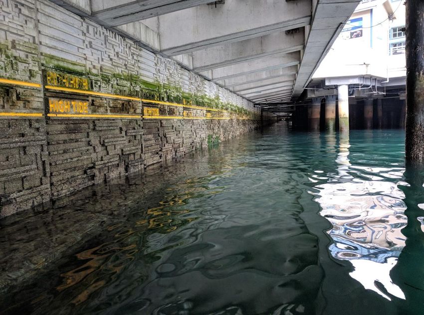
Elliott Bay - Central Seawall
LOCATION SEATTLE, WASHINGTON
LED BY James Corner Field Operations
SETTING Urban, hard edge, salt water, built habitat
KEY DESIGN ELEMENTS Textured concrete, cantilevered walkway, light penetrating blocks
APPROXIMATE SIZE 1 km
13Living Shorelines for the Vancouver Region | Jackson-Drouin
Expert Interview with Jeff Cordell
The central seawall is part of the overall revitalization and rebuild of the Alaskan Way Viaduct and
Alaskan Way promenade on Elliot Bay. The seawall is unique for the focus on ecological
integration, with a salmon corridor that supports migrating juvenile salmon (“Central Seawall
Project,” 2017). The design uses “marine mattresses” and benches to increase habitat complexity
and light penetrating tiles that allow light through the overhanging walkway. These tiles allow
enough light to promote fish to use the area under the cantilever (J. Cordell, personal
communication, January 22, 2021).
Photo credit: Kerry Accola, UW Wetland Ecosystem Team
Figure 10. Underneath the cantilevered walkway at Elliott Bay (used with permission)
14Living Shorelines for the Vancouver Region | Jackson-Drouin
Photo credit: Jeff Cordell, UW Wetland Ecosystem Team
Figure 11. Marine mattresses and benches exposed at low tide at Elliott Bay Seawall (used with permission)
Elliott Bay - Habitat Beach
LOCATION SEATTLE, WASHINGTON
LED BY James Corner Field Operations
SETTING Urban, salt water, built habitat
KEY DESIGN ELEMENTS Urban, salt water, built habitat, beach nourishment
APPROXIMATE SIZE 60 m
The revitalization and rebuild of the Alaskan Way Viaduct and Alaskan Way promenade includes
additional habitat improvements like the Habitat Beach built between Colman Dock and Pier 48
(“Explore Seattle’s New Waterfront - Pioneer Square” n.d.). The pocket beaches, two in total,
along Alaskan way require lots of armoring to keep them in place (J. Cordell, personal
communication, January 22, 2021). This beach adds more habitat for juvenile salmon and other
species.
15Living Shorelines for the Vancouver Region | Jackson-Drouin
Figure 12. Habitat Beach next to Alaskan Way (Google Earth)
Seal Beach National Wildlife Refuge – Sediment Augmentation
LOCATION NORTHWEST ORANGE COUNTY, CALIFORNIA
Southwest Wetlands Interpretive Association, State Coastal
LED BY
Conservancy, US Fish and Wildlife
SETTING Salt marsh
KEY DESIGN ELEMENTS Thin layer sediment augmentation
APPROXIMATE SIZE 4 hectares
This is a pilot project (with 5 year post-addition monitoring) to determine whether thin-layer
sediment augmentation to an existing marsh will increase elevations and if it is a useful tool to
help habitat adapt to sea level rise on the west coast (Southwest Wetland Interpretive
Association, 2019). Goals of the project include achieving at least 7 cm of elevation of the marsh,
stem lengths of cordgrass comparable to before sediment addition and invertebrate biodiversity
comparable to that of reference sites (Gilligan, 2018).
16Living Shorelines for the Vancouver Region | Jackson-Drouin
Figure 13. Seal Beach National Wildlife Refuge (Google Earth)
Hunter’s Point South Park
LOCATION QUEENS - NEW YORK CITY, NEY YORK
LED BY SWA/Balsley, Weiss/Manfredi, Arup
SETTING Urban, salt marsh creation
Salt marsh installed behind hard edge, considerations for sea level
KEY DESIGN ELEMENTS
rise, cantilever viewing platform
APPROXIMATE SIZE 4.4 hectares
The park project was designed to respond to flooding from sea level rise. The created salt marsh
is set back from the water’s edge with promenades on the edges (McKnight, 2018). The park
includes an iconic cantilevered viewing platform (McKnight, 2018). The marsh is flooded at high
tide via culverts through the rip rap shoreline.
17Living Shorelines for the Vancouver Region | Jackson-Drouin
Figure 14. Salt marsh set inland from rip rap shoreline at Hunter’s Point South Park (“Hunter’s Point South Park – Phase 2 –
Overlook by Daniel Prostak, CC by SA 4.0)
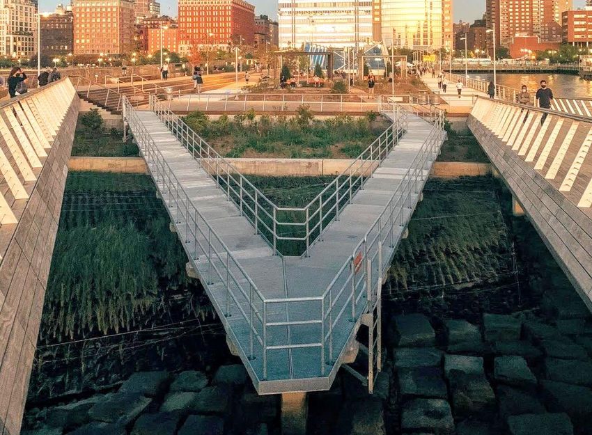
Tide Deck at Pier 26
LOCATION HUDSON RIVER – NEW YORK CITY, NEW YORK
OLIN Studio, Rafael Viñoly Architects, Mueser Rutledge Consulting
LED BY
Engineers, Biohabitats and Tillett Lighting Design Associates
SETTING Urban, brackish and salt marsh
KEY DESIGN ELEMENTS Created salt marsh, tidepools, submerged structures
APPROXIMATE SIZE Marsh area = 1300 m2
Located in the Hudson River estuary, the Tide Deck at Pier 26 includes an engineered salt marsh
and constructed tide pools. The marsh and tide pool flood and emerge with the tides. The deck
features three types of habitat: native planted salt marsh, engineered tide pools and submerged
habitat for oysters (“Pier 26 Tide Deck,” n.d.). The marsh uses a polyethylene matrix rather than
soil. The tide deck is part of the overall revitalization of Pier 26, which also includes additional
habitats such as woodland forest, coastal grassland, and maritime shrubs (Young, 2020).
18Living Shorelines for the Vancouver Region | Jackson-Drouin
Photo credit: Mark Bauer
Figure 15. Tide deck at Pier 26 below two overhanging walkways (used with permission)
Leonardtown Wharf
LOCATION LEONARDTOWN, MARYLAND
Crozier Associates, KVO Industries, Biohabitats, David H. Gleason
LED BY
Associates, Cianbro Inc., and W. M. Davis, Inc.
SETTING Urban, saltwater, coastal plain
KEY DESIGN ELEMENTS Planted tidal wetland, observation walkway, boardwalk
APPROXIMATE SIZE 1600 m2
The project features a boardwalk next to the designed and planted tidal wetlands and marshes,
which connect to the existing, natural wetlands (“Leonardtown Wharf Living Shoreline,” n.d.).
The project is within Maryland’s designated Critical Area for natural resource protection and
therefore required special consideration for the shoreline.
19Living Shorelines for the Vancouver Region | Jackson-Drouin
Figure 16. Leonardtown Wharf (Google Earth)
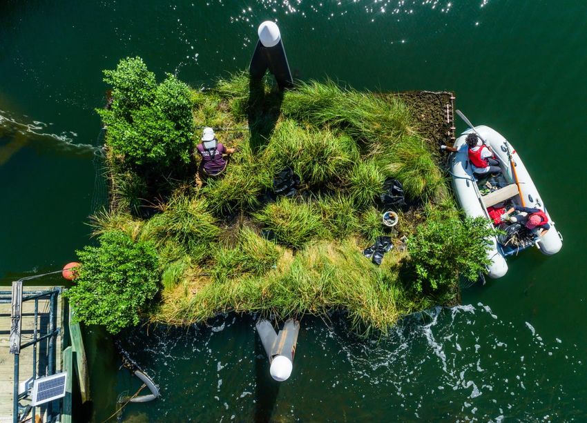
National (USA) Aquarium Floating Wetland
LOCATION BALTIMORE HARBOUR, MARYLAND
LED BY National Aquarium, Ayres Saint Gross, Biohabitats and others
SETTING Urban, salt water, brackish water, harbour
KEY DESIGN ELEMENTS Built wetland, floating wetland, tethered wetlands
APPROXIMATE SIZE 35 m2
Expert Interview with Charmaine Dahlenburg
The current wetland is custom made with plastic matrix for plants to grow hydroponically,
features an s-shaped channel through the center and is tethered to pilings, rather than being
anchored. The wetland has bubblers for aeration and successfully sequesters excess nitrogen
from the harbour. The current wetland is a third iteration of the concept. There are plans for a
full-scale installation in the harbour, with construction potentially starting next year (2022) (C.
Dahlenburg, personal communication, February 18, 2021).
20Living Shorelines for the Vancouver Region | Jackson-Drouin
Photo credit: National Aquarium, Baltimore MD
Figure 17. Overview of the Floating Wetland in Baltimore Harbour (used with permission)
21Living Shorelines for the Vancouver Region | Jackson-Drouin
Photo credit: National Aquarium, Baltimore MD
Figure 18. The Floating Wetland in Baltimore Harbour attached to two pilings (used with permission)
Photo credit: National Aquarium, Baltimore MD
Figure 19. Wetland plants growing in a polyethylene/plastic matrix (used with permission)
22
Photo credit: National Aquarium, Baltimore MDLiving Shorelines for the Vancouver Region | Jackson-Drouin
Hancock County Living Shoreline
LOCATION HANCOCK COUNTY MARSH COASTAL RESERVE, MISSISSIPPI.
LED BY Anchor QEA
SETTING Wetland, coastal reserve, saltwater
KEY DESIGN ELEMENTS Breakwaters, salt marsh creation, subtidal reef
APPROXIMATE SIZE 9.5 km
Expert Interview with Wendell Mears
There are three components to the overall project: the construction of 9.5 km (5.9 mi) of living
shoreline with breakwaters to reduce erosion, the construction of 19 hectares (46 acres) of
marsh with dredged materials, and the creation of subtidal reefs in an adjacent bay (Mears, et al.,
2018). The completed breakwater is a segmented design intended to reduce the wave energy of
a 1 ft [0.3m] wave (W. Mears, personal communication, November 20, 2020), and is able to
reduce a 1 – 1.2 m wave to a 0.15 m wave (W. Mears, personal communication, January 8, 2021).
Photo credit: Wendell Mears, Mobile AL
Figure 20. Living shoreline breakwaters in Hancock County, MS (used with permission)
Photo credit: Wendell Mears, Mobile AL
Figure 21. Straight on view of living shoreline breakwaters in Hancock County, MS (used with permission)
23Living Shorelines for the Vancouver Region | Jackson-Drouin
Deer Island Salt Marsh Restoration
LOCATION BILOXI, MISSISSIPPI
LED BY Anchor QEA
SETTING Gulf Coast plain, salt marsh
KEY DESIGN ELEMENTS Salt marsh cell
APPROXIMATE SIZE 16 hectares
Lost salt marsh habitat on the island was restored using 279 000 m3 of dredge material from the
local Federal navigation channel (Roth et al., 2012). The “cell” or placement area was contained
by a dike that was constructed at about 2 m lower low mean tide, with a hardened riprap to
refract waves (Roth et al., 2012).
Photo credit: Wendell Mears, Mobile AL
Figure 22. An example of a salt marsh cell being constructed in Heron Bay, Hancock County, MS (used with permission)
Recycled Park floating wetlands
LOCATION ROTTERDAM, NETHERLANDS
LED BY Recycle Island Foundation
SETTING Urban, harbour
KEY DESIGN ELEMENTS Recycled materials, created salt marsh
APPROXIMATE SIZE 46 m2 (each)
In 2018, a prototype of wetlands made from recycled plastic was installed along with a floating
park (Berke, 2018). In addition to the wetlands, the park also included seating areas, all made
with the same recycled material (Berke, 2018). The islands are hexagonal in shape and fit
together to create a sprawling, floating wetland are seating area. The Recycle Island Foundation
utilized litter traps to collect plastic heading for the ocean to create the islands (Solar Impulse
24Living Shorelines for the Vancouver Region | Jackson-Drouin
Foundation, n.d.). The islands create wetland habitat that is engaging and publicly accessible in
an urban setting.
Figure 23. Recycled Park in Rotterdam, Netherlands. Islands and floating wetlands are highlighted in pink (Google Earth)
Photo credit: clearwater.eu
Figure 24. Recycled park’s floating wetlands (used with permission)
25Living Shorelines for the Vancouver Region | Jackson-Drouin
Photo credit: clearwater.eu
Photo credit: clearwater.eu
Figure 25. Recycled park with floating wetlands and seating area (used with permission)
Carss Bush Park
LOCATION KOGARAH BAY – SYDNEY, AUSTRALIA
LED BY Georges River Council
SETTING Urban, saltwater, park land
KEY DESIGN ELEMENTS Salt marsh bench, rocky intertidal, tidal mudflats
APPROXIMATE SIZE 1375 m2 saltmarsh and 112 m2 rockpool habitat
Failure of the park’s outdated seawall and erosion behind it, led to the development of an
ecologically engineered shoreline solution. Multiple habitat types were considered in the
shoreline design including salt marsh benches, rock pools/tide pools, rocky intertidal and tidal
mudflats. Considerations made for the site design included balancing the amount of riparian
habitat installed and the playing fields in the park for recreational use. The project resulted in
improved biodiversity, aesthetics, social and cultural values, and improvements to the natural
ecology of the site (Heath & Council, 2017).
26Living Shorelines for the Vancouver Region | Jackson-Drouin
Figure 26. Carss Bush Park (Google Earth)
Living Seawall Tiles
LOCATION SYDNEY, AUSTRALIA
LED BY Sydney Institute of Marine Science (SIMS), Reef Design Lab
SETTING Urban, hard edge, harbour
KEY DESIGN ELEMENTS “Greening” seawalls
APPROXIMATE SIZE Customizable
The concept of increasing the habitat value of seawalls has manifested in different designs and
forms. The Living Seawall tiles created by the Sydney Institute for Marine Science (SIMS) and Reef
Design Lab use a hexagonal shape and are designed with recruitable habitat in mind. SIMS has
installed these tiles in multiple locations with success (Sydney Institute of Marine Science, 2021).
27Living Shorelines for the Vancouver Region | Jackson-Drouin
Photo credit: Alex Goad, Reef Design Lab, AUS
Figure 27. Living Seawall tiles installed on a seawall in Sydney, AUS (used with permission)
Photo credit: Alex Goad, Reef Design Lab, AUS
Figure 28. Closer look at the Living Seawall tiles (used with permission)
28Living Shorelines for the Vancouver Region | Jackson-Drouin
Interviews and Meetings
Meeting summaries and full meeting notes are included in the internal version of this report
(Appendix A).
Sturgeon Bank: Biophysical Conditions and Selected Focal Species
Biophysical Conditions
Sturgeon Bank is part of the complex Fraser River estuarine system. A broad summary of some of
the key aspects of the coastal dynamics of the area are described here. General data and
information about the biophysical conditions of the estuary and Sturgeon Bank exists, but there
is a need for additional research to further understand sediment and current dynamics.
Modelling is needed to fully inform shoreline restoration work.
Sediment Transport
A key interest for Sturgeon Bank and Iona Island is the sediment regime and flow. The sediment
and deltaic regime of the region relies on the freshwater discharge from the Fraser River which is
approximately 12 million cubic meters per year (Atkins et al., 2016). This discharge is dominated
by the late May to early June freshet, and the sediment carried by the freshet is typically made
up of 50% silt, 35% sand and 15% clay (Williams et al., 2009). Most of the sediment is carried
through the Main Arm of the Fraser River, with very little (3% - 4%) sediment being discharged
through the Middle Arm onto Sturgeon Bank (McLaren & Tuominen, 1998) . Sediment is
delivered from the Main Arm to Sturgeon Bank by northward currents (McLaren & Tuominen,
1998). The flood tide on Sturgeon Bank is the dominant tide and brings in most of the sediment
with the influx of water (Atkins et al., 2016).
There is a long list of human alterations to the Fraser River Delta, including dikes, channel training
structures, and dredging, all of which have altered the natural sediment deposition patterns on
Sturgeon Bank. The current conditions on Sturgeon Bank are considered erosional (Atkins et al.,
2016; McLaren & Tuominen, 1998). Though erosional conditions are noted for the island, it is
more likely there is a mix of erosion and accretions occurring. Shoreline change from 1952 –
2009 were analyzed by Nick Page (2011) and found that the shores of the northern sections
(North Arm Jetty) was variable, with periods of accretions and erosion with the region of the
eastern bay being less variable with a consistent rate of progradation (Page, 2011).
29Living Shorelines for the Vancouver Region | Jackson-Drouin
Tides
Tides on Sturgeon Bank are mixed and semidiurnal with a tidal range of 5.0 m (extreme tidal
range of 5.9 m) (Atkins et al., 2016). On Sturgeon Bank, tides typically flood to the northwest and
ebb to the southeast (Atkins et al., 2016).
Tidal elevations for north Sturgeon Bank are as follows (Fisheries and Oceans Canada, 2019):
• Higher High Water Large Tide (HHWHT): 2.1 m
• Higher High Water Mean Tide (HHWMT): 1.5 m
• Mean Water Level (MWL): 0.0 m
• Lower Low Water Mean Tide (LLWMT): -2.0 m
• Lower Low Water Large Tide (LLWLT): -3.1 m
Currents
The surface current north of the Steveston Jetty often flows north (Figure 29), moving fresh
water northward across Sturgeon Bank. This happens even during strong ebbs, which typically
flow southeast. This nearshore current is more likely to be present between May and September
(Thomson, 1981). This current disperses sediment across Sturgeon Bank but does not cause a
significant deposition at Iona Island (McLaren & Tuominen, 1998).
Wind & Waves
Waves from storm events are particularly important in the region of Sturgeon Banks (Williams et
al., 2009). All wave heights are limited by the fetch of the wind and in Sturgeon Bank, the most
extreme wave heights come from the northwest, which develop over a possible fetch of 120 km
(Thomson, 1981). Wave data for Sturgeon Bank (February 1974 - April 1976) shows that
significant waves never exceeded 2.7 m and the max heights were always less than 4.0 m, with
calm conditions occurring 27% of the study time (Thomson, 1981). The largest significant wave
heights, up to 2.5 m with periods of 7 to 8 s, occur on occasion on Sturgeon Bank due to the
opposing current created from the flow out of the North Arm of the Fraser River (Thomson,
1981).
There is a drastic change from southeasterlies to easterly winds off the Fraser River, largely
influenced by air moving through the Fraser Valley. This pattern persists through the colder
months (from October to March). In the spring, winds are mostly southeasterly to easterly and by
summer wind speeds are generally less than 4.5 m/s but are more erratic than the rest of the
year (Thomson, 1981). The northern part of the estuary, including Sea Island and Iona Island, are
considered to be relatively protected from the full strength of winter winds in comparison to the
30Living Shorelines for the Vancouver Region | Jackson-Drouin
estuary’s southern areas, largely due to the topography of the estuary (Thomson, 1981). In the
summer, the sea-land breeze circulation, influenced by the warming of the land, dominates the
winds that occur.
Figure 29. Regional wind patterns and surface currents occurring at Iona Island. Adapted from Thomson (1981)
Data from a weather station at the Vancouver International Airport is depicted below (Figure 30).
Winds with speeds of 4 -11 m/s occur around 20% of the time year-round with most winds
coming from the east and southeast.
31Living Shorelines for the Vancouver Region | Jackson-Drouin
Figure 30. Wind data from Vancouver International Airport https://www.windfinder.com/windstatistics/vancouver_airport
Focal Species and Habitat requirements
Habitat Overview
Sturgeon Bank is part of the provincially designated Sturgeon Bank Wildlife Management Area
(SBWMA) which spans from the north tip of the North Jetty and south to the most southern
outflow of the Main Arm of the Fraser River. The SBWMA hosts all five species of Pacific salmon
during migration, using its habitat for shelter and acclimatization, as well as 27 species of other
non-salmonid fish (Government of B.C., n.d.). The area is also part of the Fraser River Estuary
Important Bird and Biodiversity Area which supports several nationally, continentally, and globally
significant populations of bird species. The island is also an important location along the Pacific
Flyway, supporting millions of birds on their spring and fall migrations (Williams et al., 2009).
Species and habitats that are supported at Iona Island in particular are influenced by historical
and current activities there (Page & Schaefer, 2019). For example, previous deposition of dredge
material on top of wetlands created conditions for establishment of rare, early successional
ecological communities (Page, 2011). Page identified three such communities considered rare in
British Columbia within the regional park, these are: large-headed sedge, dune wildrye and
seashore salt grass dominated communities (Page & Schaefer, 2019). In addition to these rare
communities, there are other noteworthy species at Iona, such as the locally rare Yellow-headed
Blackbird (Xanthocephalus xanthocephalus), Little Brown Bat (Myotis lucifugus) and the likely
presence of the Lower Fraser River population of White Sturgeon (Acipenser transmontanus)
(Page & Schaefer, 2019). Each species is considered representative of the habitat they occupy.
32Living Shorelines for the Vancouver Region | Jackson-Drouin
Sandpipers and Mudflat habitat
Sandpipers in the Genus Calidris have been identified as focal species and representatives of
mudflat habitat. Both Western Sandpipers (Calidris mauri) and the Pacific population of Dunlin
(Calidris alpina) are considered.
The most numerous shorebird on the Pacific coast is the Western Sandpiper (Butler et al., 1996)
and they use the Fraser River Estuary as a stopover location during their northbound (spring) and
southbound (fall) migrations (Butler et al., 1996). The Fraser River Estuary alone supports 70% of
the world's Western Sandpiper population (Rantanen, 2019), so they are celebrated birds in the
region. Unlike the migratory Western Sandpipers, the entire Pacific population of Dunlin are
found here (Rantanen, 2019) and at Iona, Dunlin are common from November through to April
(Toochin, 2014).
The mudflats can be a very productive habitat, and recently it has been understood that a key
source of primary production in mudflats is biofilm. Biofilm is a layer that develops on the surface
of mudflats, and it contains microbes, diatoms, and other fauna (Schnurr et al., 2020). Western
Sandpipers are specialized to graze on this thin layer, with biofilm present in dropping samples
(Jardine, 2015) and stomach content samples (Kuwae et al., 2008; Mathot et al., 2010). This
foraging method is also utilized by Dunlin, though it appears to a lesser degree (Mathot et al.,
2010). Western Sandpipers are common in the Fraser River Estuary in the later part of April
through to mid-May as well as from July to September (Toochin, 2014) aligning with the species’
spring and fall migrations (Butler et al.,1996). The Western Sandpiper is smaller than the Dunlin,
and the presence of both species often affect feeding behaviours (“Western Sandpiper”, 2019).
For sandpipers who use this region as a stopover location, it is paramount that they acquire the
energy needed for their journey, so conditions that promote a healthy biofilm habitat are key.
The migratory patterns of Western Sandpipers differ with direction and season, with large flocks
travelling together and stopping at a few large estuarine sites travelling northward and smaller,
more dispersed flocks travelling southward (Butler et al., 1996). One recent explanation may be
that the northward migration aligns with the increased lipid and fatty acid production by diatoms
in biofilm on Roberts Bank (Schnurr et al., 2020). This contributes to the quality of Roberts Bank
and the Fraser River Estuary as a stopover site (Schnurr et al., 2020). This increased lipid and
diverse fatty acids production in diatoms has been observed on mudflats at a higher elevation (~
1m – corresponding to geodetic elevations) and that have high environmental stress (salinity and
temperature changes), which induce lipid storage (Schnurr et al., 2020). Though biofilm habitat is
important, it appears that the sandpipers on Sturgeon Bank, and around Iona Island in particular,
may rely more heavily on small invertebrates than on biofilm (Jardine et al., 2015). The size of the
33Living Shorelines for the Vancouver Region | Jackson-Drouin
small invertebrates ranges from 1 mm to 10 mm and includes amphipods, cumaceans, bivalves
and gastropods and made up the majority of dropping samples (Jardine et al., 2015). Ultimately,
sandpipers rely on mudflats not only as a migratory fuel source, but also as a yearlong habitat.
These habitats should be prioritized to promote healthy biofilm production and healthy
invertebrate populations.
Forage Fish and Gravel Beach habitat
Both Pacific Sand Lance (Ammodytes personatus) and Surf Smelt (Hypomesus pretiosus) have
been considered as focal species and represent the gravel beach habitats that they use to spawn.
Though there is little formal documentation of their presence at Iona and no observations on
iNaturalist for either species, there is anecdotal evidence pointing to great potential for spawning
habitat at Iona Island.
Pacific Sand Lance and Surf Smelt are small schooling fish that are key prey animals that support
many ecosystems and food webs in the Salish Sea and beyond (Penttila, 2007). Iona island may
already provide spawning habitat for these species. As of 2017, spawning habitat surveys have
not been widely done in British Columbia, so specific locations with suitable and potential
spawning beaches are not formally documented (de Graaf, 2017). Immediate action to map and
identify spawning habitat has been recommended (Buchanan, Lesperance, McArdle, Sandborn, &
Curran, 2019). Extensive work has been done in Puget Sound, dating back to the 1970s, to
investigate and map spawning habitat (Buchanan et al., 2019; Penttila, 2007). Though not well
mapped locally, spawning habitat requirements are well understood, with some modelling of
suitable habitat for both Pacific Sand Lance and Surf Smelt having been done (Cook, 2018; de
Graaf & Penttila, 2014). Surf Smelt and Sand Lance spawn near the high tide line on beaches
composed of pebble, gravel and sand with vegetation that provides shade (Province of British
Columbia, 2014). In addition, a healthy spawning beach has an intact marine riparian zone and
clean water (de Graaf, 2017). Shade vegetation is particularly important for the
populations/stocks of Surf Smelt that spawn in the summer (de Graaf, 2017) but is less so for
Sand Lance and other Surf Smelt stocks who spawn in the winter (Penttila, 2007). Sand lance
tend to use the same beaches and intertidal zone as Surf Smelt, but are also found lower, near
the initial beach slope (de Graaf, 2017; Province of British Columbia, 2014). The highest densities
of embryos (of both species) are found within the seaweed wrack lines (de Graaf, 2017).
Little information has been documented about the presence of suitable habitat on Iona Island,
but there is likely potential to incorporate elements of suitable habitat into the shoreline design.
Raincoast Conservation Foundation sampling in 2018 did find Pacific Sand Lance present around
34Living Shorelines for the Vancouver Region | Jackson-Drouin
Iona Island (Page & Schaefer, 2019). Penttila (2007) goes into detail about spawning habitats in
the technical report for the Puget Sound Nearshore Partnership Marine Forage Fishes in Puget
Sound and this information is briefly summarized in Table 1.
TABLE 1. SUMMARY OF DETAILS - SURF SMELT AND PACIFIC SAND LANCE SPAWNING
HABITATS (PENTTILA, 2007)
Grain Size Spawning Range Spawning
(bulk of material) (shoreline) Season
Extreme High Water +/- 2.1 m tidal Throughout
Surf Smelt 1 - 7 mm
elevation year
Pacific Sand Mean High Higher Water +/- 1.5 m tidal November -
0.2 - 0.4 mm
Lance elevation February
Juvenile Chinook Salmon and Tidal Marsh Habitat
All five species of Pacific salmon are found in the SBWMA during their migrations (Government of
B.C., n.d.). The focus for this report will be on juvenile Chinook salmon (Oncorhynchus
tshawytscha) as they are the life stage that utilizes tidal marsh habitat for the longest amount of
time, and due to their cultural, environmental, recreational, and economic importance. Chinook
play an important role as a key prey species for the southern resident killer whale population
(Ford et al., 2010). Healthy habitat for juvenile salmon in their rearing years and migration is key
to their overall health. Estuaries play an important role as they offer relatively safe and
productive habitat for many species of fish. Of the many habitat types found within an estuary, it
is the estuarine marshes that host the greatest numbers of juvenile Chinook (Chalifour et al.,
2019; Levy & Northcote, 1982). While eelgrass meadows have been found to have a larger
species richness, meaning they host a larger amount of species overall (Chalifour et al., 2019),
Chinook juveniles are most abundant in the marshes of the Fraser River Estuary (Chalifour et al.,
2019; Levy & Northcote, 1982). This demonstrates the species’ dependence on this type of
habitat. From March to June (Page & Schaefer, 2019) Chinook juveniles reside in estuaries,
spending the longest amount of time relative to other species (Levy & Northcott, 1982), staying
for up to a month (Page & Schaefer, 2019). There is less competition for space and food in the
marshes (Levy & Northcott, 1982) and high growth opportunities. The highest valued habitat
type in estuarine marshes is sedge and rush habitat (Levings, 1991). Adams (2002) distinguishes
between lower and upper estuarine marshes, distinguished by the limit of the salt wedge. The
35Living Shorelines for the Vancouver Region | Jackson-Drouin
lower estuarine marsh type that is likely to occur at Iona is a brackish marsh, which occurs at the
most downstream reaches of the main channels, and is characterized by species like Olney’s
sedge (Scirpus pungens) or American three square bulrush (Scirpus americanus), softstem
bulrush (Schoenoplectus tabernaemontani), Lyngby’s sedge (Carex lyngbyei) and Baltic rush
(Juncus balticus), typically occurring in a consistent zonation pattern from lower to higher
elevation (Adams, 2002). The tidal marsh present on the southeast side of Iona Island is
dominated by cattail species (Typha spp.) and is considered lower quality (though still very high
quality) fish habitat, as the cattails grow very densely (Page & Schaefer, 2019). McDonald Slough
is an area of importance for juvenile Chinook, evidenced by their presence during Raincoast
Conservation Foundation’s 2018 sampling program (Page & Schaefer, 2019).
False Creek: Biophysical Conditions and Selected Focal Species
Biophysical Conditions
False Creek is an urban site with most of its shoreline hardened, and some natural shores
incorporated. A broad summary of the key coastal dynamics is described here. Additional work by
the City of Vancouver and others is in progress to better understand the physical, chemical, and
biological characteristics of False Creek.
Water Quality
In False Creek the water quality parameter that has received the most study is Escherichia coli
and fecal coliforms in general. Cummings (2016) reported that E. coli concentrations increased
from west to east, evidenced in two data sets (1993 to 2012, and 2013 to 2016). Shoreline
concentrations of E.coli are consistently higher than mid-channel values. A 30-day average for
July 2016 for both mid-channel and shoreline sites found the mid-channel average in east False
Creek to be 142.3 MPN/100ml whereas the average of the associated shoreline samples ranged
from 60 - 1799 MPN/100ml. One sample exceeding the secondary contact guideline of 1000
MPN/100ml. Fecal coliform concentrations were higher in the winter, but there was not enough
data to confirm a seasonal pattern nor a consistent correlation with temperature (Cummings,
2016).
Salinity & Temperature
Cummings (2016) found that from 2013 to 2015 “the average winter salinity was 23.8 PSU, while
the average summer salinity was 16.8 PSU” (p. 27). Depth profiles (salinity and temperature)
were collected and showed that the eastern part of False Creek is the most stratified, meaning
the layers of warm/less saline, and cold/more saline water are most distinct and less mixed. In
36Living Shorelines for the Vancouver Region | Jackson-Drouin
July 2016 in eastern False Creek, this interface occurs somewhere between 3 and 4 meters deep,
here temperatures dropped from 17.2oC to 13.8oC and salinity rose from 16.4 PSU to 24.2 PSU
(Cummings, 2016). This contributes to the unmixed and stratified nature of the eastern region of
the inlet. Cummings also noted that temperatures are slightly higher in east False Creek (2016).
Tides
Tides in False Creek are mixed and semi-diurnal. Generally, large influx of water into the inlet
occurs only during large flood tides, with drainage occurring with large ebb tides (Figure 31).
Tidal elevations for east False Creek (provided by Kerr Wood Leidal) are as follows:
• Higher High Water Large Tide (HHWHT): 2.0 m
• Higher High Water Mean Tide (HHWMT): 1.5 m
• Mean Water Level (MWL): 0.1 m
• Lower Low Water Mean Tide (LLWMT): -1.8 m
• Lower Low Water Large Tide (LLWLT): -2.9 m
Figure 31. Surface currents during tidal changes in Burrard Inlet that influence False Creek. Adapted from Thomson (1981)
37You can also read