Implementation of Nature-Based Solutions for Hydro-Meteorological Risk Reduction in Small Mediterranean Catchments: The Case of Portofino Natural ...
←
→
Page content transcription
If your browser does not render page correctly, please read the page content below
sustainability

Article
Implementation of Nature-Based Solutions for
Hydro-Meteorological Risk Reduction in Small
Mediterranean Catchments: The Case of Portofino
Natural Regional Park, Italy
Laura Turconi 1 , Francesco Faccini 1,2, * , Alessandra Marchese 3 , Guido Paliaga 1 ,
Marco Casazza 4, * , Zoran Vojinovic 5 and Fabio Luino 1
 1    Istituto di Ricerca per la Protezione Idrogeologica, Consiglio Nazionale delle Ricerche, Strada della Cacce 73,
      10135 Torino, Italy; laura.turconi@irpi.cnr.it (L.T.); guido.paliaga@irpi.cnr.it (G.P.);
      fabio.luino@irpi.cnr.it (F.L.)
 2    Dipartimento di Scienze della Terra dell’Ambiente e della Vita, Università di Genova, Corso Europa 26,
      16132 Genova, Italy
 3    Geographical Information System International Group (GISIG), Via Piacenza 54, 16138 Genoa, Italy;
      a.marchese@gisig.it
 4    Department of Engineering, Parthenope University of Naples, Via Amm. F. Acton 38, 80133 Naples, Italy
 5    IHE Delft Institute for Water Education, Westvest 7, 2611 AX Delft, The Netherlands; z.vojinovic@un-ihe.org
 *    Correspondence: faccini@unige.it (F.F.); marco.casazza@uniparthenope.it (M.C.)

 Received: 10 December 2019; Accepted: 6 February 2020; Published: 8 February 2020

 Abstract: Nature-based solutions (NBS) are usually defined as complementary or alternative solutions
 to “grey infrastructures” (traditionally made with cement) aimed at conserving and regenerating
 the functionality of natural and semi-natural ecosystems. The research to date shows a considerable
 potential of NBS to address the current challenges related to climate change and geo-hydrological
 risks. Despite significant interest in NBS by researchers and practitioners, knowledge concerning
 their practical implementation, monitoring, and evaluation is still lacking. This is particularly true
 for large-scale NBS. The present paper discusses how such solutions can be implemented in the
 context of hydro-meteorological risk reduction in small Mediterranean catchments with a strong
 tourist vocation. The work presented here is situated within the RECONECT Project (Regenerating
 ECOsystems with Nature-based solutions for hydro-meteorological risk rEduCTion), which aims to
 contribute to a European reference framework on NBS by demonstrating, upscaling, and replicating
 large-scale NBS in rural and natural areas. The Italian case study of RECONECT is the Portofino
 Natural Regional Park, which represents a unique natural landscape element with high ecologic,
 social, and economic (touristic) value, which is threatened by a range of geo-hydrological hazards,
 such as flash floods, hyper-concentrated floods, shallow landslides, rockfalls, and storm surges.
 This paper also presents details of NBS interventions in two pilot catchments (San Fruttuoso and
 Paraggi) visited by thousands of tourists throughout the year. It addresses some of the key aspects
 related to monitoring meteorological and hydrological processes, as well as remote sensing activities
 (i.e., LiDAR surveys), which are necessary for the identification of critical-instability areas along
 waterways and the reconstruction of dry stone walls. Lastly, a discussion of relevant mitigation and
 adaptation strategies that are potentially replicable at national and international levels is also provided.

 Keywords: nature-based solutions; hydro-meteorological risk reduction; Portofino Natural Regional
 Park, Liguria; Italy

Sustainability 2020, 12, 1240; doi:10.3390/su12031240                            www.mdpi.com/journal/sustainability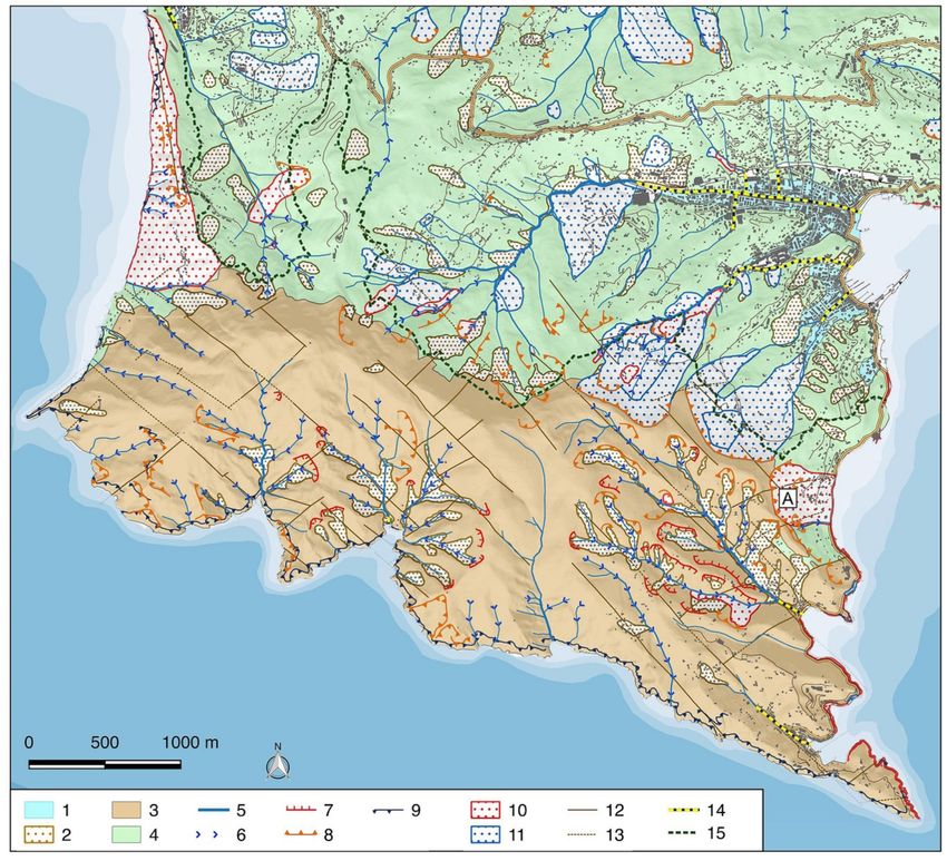
Sustainability 2020, 12, 1240                                                                         2 of 22

1. Introduction
       The European Commission defines nature-based solutions (NBS) as “solutions that aim to help
societies address a variety of environmental, social and economic challenges in sustainable ways.
They are actions inspired by, supported by or copied from nature [ . . . ]. Nature-Based Solutions
use features and natural processes, such as its ability to store carbon and regulate water flows,
in order to achieve desired outcomes [ . . . ]” [1]. With respect to geo-hydrological risk, including the
impact of floods, erosion, mass transport of debris flow, and triggering landslides, we can distinguish
several types of NBS [2] that may be suitable for different environmental conditions [3]. These NBS
can be implemented to reduce impacts and bring benefits with respect to (a) water management
(i.e., reducing flood risks, storing and infiltrating rainfall run-off, reducing erosion); (b) society (i.e.,
an increased esthetic value of the area, e.g., increasing tourism, walking, jogging, cycling); (c) economics
(i.e., reducing the damage from geo-hydrological events, energy saving); and (d) the environment (i.e.,
reducing air and noise pollution).
       A single NBS site can be considered and evaluated either on its own or in combination with
other NBS [3]. Combinations can also be created between one or more NBS with grey infrastructures,
which are usually referred to as hybrid solutions [4,5], and these configurations sometimes give
the most effective results. Some studies have shown that NBS are likely to be more effective when
implemented through cooperation with local people and with a good governance model [6].
       Small scale NBS [2] are usually applied to a single site or relatively small areas such as a
single building or a street. Examples of small-scale NBS are green roofs, rain gardens, small-scale
detention or retention ponds, permeable pavements, bio-retention, and vegetated swales. Large-scale
NBS [2] are usually represented by either large-scale, single interventions or a number of different
NBS interconnected within a larger hydrological system. An effective example of large-scale NBS
implementation is the Dutch “Room for the River Program”, which involved 39 local projects based
on nine different types of measures. This program not only achieved benefits in terms of flood risk
reduction, but it also produced other benefits, including improvements in spatial quality as well as
habitat and biodiversity restoration [7,8]. Another case study is the Laojiee River Project in Taiwan,
where the channelized watercourse was changed into an accessible green infrastructure corridor for
the public, increasing recreation activities and the value of the area [9].
       The process of implementing NBS is rather complex and it requires the active involvement of
stakeholders that often have conflicting interests. A typical decision-making process concerning the
implementation of NBS is based on three main steps [1–3]: (1) selection, which takes into consideration
the characteristics of the site, land use, governance aspects, and environmental needs; (2) evaluation,
through performance indicators; and (3) optimization, to select optimal NBS configurations according
to the particular situation.
       There is a need for more research efforts in terms of assessing the costs and benefits of large-scale
NBS and to test their efficacy in different landscape contexts. To boost such a research and evidence
base, the European Commission (EC) is financing several projects within the Horizon 2020 Framework
Program. The first EC-funded large-scale NBS projects are RECONECT (http://www.reconect.eu/),
PHUSICOS [10], and OPERANDUM [11].
       The RECONECT (“Regenerating ECOsystems with Nature-based solutions for
hydro-meteorological risk rEduCTion”) project aims to (1) demonstrate several large-scale
NBS through implementation, as well as monitoring and evaluation of their effectiveness for reducing
hydro-meteorological risks; (2) develop an information and communication technology platform that
provides real-time information about the performance of the NBS, as well as the necessary evidence
to facilitate their planning, replication, and upscaling; (3) define a roadmap (including investment
strategies and business models) for NBS implementation and operation; and (4) apply this roadmap to
several cases in Europe and beyond. This project brings together 35 international project partners,
10 demonstration sites in Europe, and 18 European and International Collaborator sites to showcase
the benefits of NBS for hydro-meteorological risk reduction. These sites were selected to cover a wide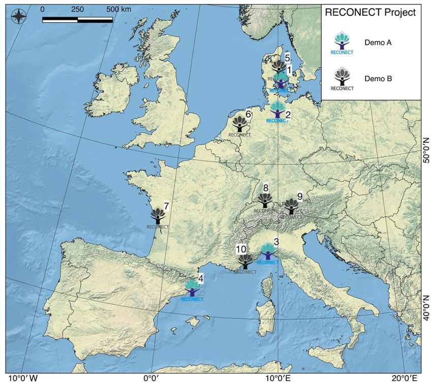
Sustainability 2020, 12, 1240                                                                                  3 of 22

and diverse range of local conditions, geographic characteristics, institutional/governance structures,
and social/cultural settings to successfully upscale NBS both throughout Europe and internationally.
     This present paper discusses some important aspects concerning the design, implementation,
monitoring, and evaluation of large-scale NBS in the Portofino Natural Regional Park (Liguria, Italy),
which is part of the RECONECT project. This area is known for its high natural capital and cultural
heritage values. Moreover, the anthropic pressure of the surrounding urbanized areas and the frequency
of extreme geo-hydrological events make this area vulnerable and particularly interesting for the
application of NBS. In what follows, we describe the Portofino case study site, the type of NBS being
implemented, the monitoring activities, and the selection of indicators for assessing NBS performance.

2. Portofino Case Study Site

2.1. The RECONECT Project Case Studies
      The RECONECT project combines ten demonstration cases which are divided in two groups
(Figure 1): Demonstrators Type A (four cases), for which the NBS sites need to be constructed and
monitored within the project lifetime; and Demonstrators Type B (six cases), for which the NBS sites
have already been implemented and will also be monitored, evaluated, and validated during the
lifetime of the project.

      Figure 1. Network of ten demonstration cases in the RECONECT Project. (1) Seden Strand, Odense,
      Denmark; (2) Elbe Estuary, Germany; (3) Portofino Natural Regional Park, Italy; (4) Tordera River Basin,
      Catalonia; (5) Greater Aarhus, Denmark; (6) Ijssel River basin, the Netherlands; (7) Les Boucholeurs,
      France; (8) Thur River Basin, Switzerland; (9) Inn River Basin, Austria; and (10) Var River Basin, France.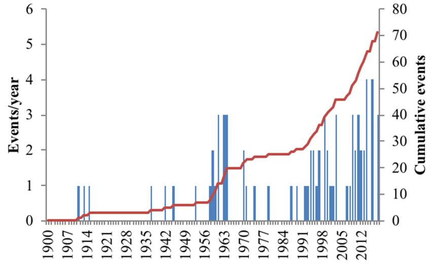
Sustainability 2020, 12, 1240 4 of 22
The project aims to demonstrate a variety of solutions in relation to hydro-meteorological risk
reduction [2,3]. The RECONECT NBS evaluation framework starts from ten challenges defined
in the EC-funded EKLIPSE project (http://www.eklipse-mechanism.eu/nbs_report) and combines
them into three categories, namely, water, nature, and people, to assess their benefits and co-benefits
(http://www.reconect.eu/).
2.2. Portofino Natural Regional Park
The Portofino Promontory (Liguria, Italy) is situated between Genoa and the border with Tuscany.
The promontory encompasses an area of 18 km2 , with a coastal development of 13 km. The terrain
topography is rather mountainous, with high elevations over a short distance from the coastline (e.g.,
Mt. Portofino with elevations of 610 m above sea level). The overall basin is comprised of several
smaller basins with surface areas of less than 1 km2 and streams along the steep slopes (mostly of
the 2◦ sensu Strahler order [12]). Within this area, there also smaller areas such as Cala d’Oro, Rio dei
Fontanini, San Fruttuoso, Ruffinale, and Vessinaro, which can only be reached by sea or by hiking
trails, i.e., there is no road access (see Figure 2A). Along the eastern part of this area, there are two
creeks: the Fondaco creek and the Acqua Viva creek (see also Figure 2A).
Table 1. Main features of the hydrographical network in the San Fruttuoso and Paraggi catchments
(see also Figure 2A).
Perimeter Mean Terraced Hydrographical Main stream
Catchment Area (km2 )
(km) steepness (%) surface (%) network length (km) length (km)
1—Rio dei Fontanini 0.585 3.507 70 2.5 2.825 1.142
2—Vallone di San Fruttuoso 0.444 2.945 64 9.4 1.953 0.838
3—Fosso dell’Acqua Viva (also
1.480 5.330 51 70 7.509 1.836
known as Paraggi Catchment)
The Portofino Natural Regional Park (Figure 2), internationally renowned for its beauty and the
high values of the settlements, vegetation, and geomorphology [13], protects the area of the promontory
with the same name, located approximately 20 km away from the city of Genoa. With respect to
the landscape and cultural values, Law 1251 has protected the Promontory of Portofino since 1935.
Since 1995, this area has been managed by the park authority established by Regional Law 12/95,
and the boundaries of the protected area have been redefined by Regional Law 29/2001 [14].
The Portofino Natural Regional Park’s main mission is the conservation of nature and biodiversity.
Being exposed to frequent and intense hydro-meteorological events, this area requires not only effective
flood protection but also sustainable solutions that can achieve the park’s main mission. Consequently,
the challenge for this area within the RECONECT project is to demonstrate NBS for risk reduction in
an integrated context of conservation and innovation. The intense urbanization that is taking place in
many areas of the Liguria region also occupies some natural areas for which NBS may be helpful in
regaining balance and harmony with nature. The high adaptability of NBS may be crucial in an area
dominated by high-energy processes, which influence a complex and heterogeneous morphology.
The area of the Portofino Natural Regional Park spreads over several municipalities (Camogli,
Portofino, Santa Margherita Ligure, and Rapallo; see Figure 2A). The first human settlements in the area
date back to Roman times. In the Middle Age, several important religious buildings were constructed
(e.g., San Fruttuoso), connected by historical trails that are still in use today [13,14]. The recent census
shows an estimated population of about 750 inhabitants.
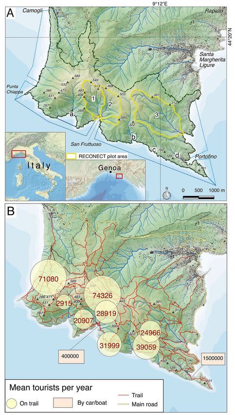
This area is very popular for tourism throughout the year. Every year, over a million tourists
visit the small town of Portofino, while the nearby town of San Fruttuoso receives about 400,000
tourists from the sea by boats. There are also a considerable number of hikers that come to this area,
together with the tourists (see Figure 2B), and the hiking paths extend over 80 km in length [15].Sustainability 2020, 12, 1240 5 of 22
Figure 2. A map of Portofino Promontory with selected catchments for nature-based solution (NBS)
interventions. (A) The Portofino Natural Regional Park boundary (dotted line): Rio dei Fontanini (1)
and Vallone di San Fruttuoso (2) catchments, as well as Fosso dell’Acqua Viva (3), also known as Paraggi
Catchment, are shown (see Table 1). Other catchments: (a) Cala d’Oro, (b) Ruffinale, (c) Vessinaro,
(d) Fondaco. (B) The average number of annual tourists along the trails within the Portofino Natural
Regional Park.Sustainability 2020, 12, 1240 6 of 22
2.3. Portofino’s Climate, Geology, and Geomorphology
The Portofino Natural Regional Park has a typical Mediterranean climate (Csa: Hot summer
Mediterranean climate, sensu Koppen [16,17]), characterized by hot summers (July Tmax 27 ◦ C and
Tmin 21 ◦ C) and mild winters (January Tmax 11 ◦ C and Tmin 5 ◦ C). The average annual rainfall is
around 1300 mm, which occurs in autumn. The climatic condition of this area is characterized by
phenomena linked to cyclogenesis on the Gulf of Genoa [18]. Especially in the period between August
and November, there are frequent intense rainfall events with short duration and high peaks (Sustainability 2020, 12, 1240 7 of 22
Figure 3. A geomorphological map of the Portofino Promontory: (1) alluvial deposit; (2) debris
cover; (3) conglomerates with sandstone layers; (4) marly limestones, clayed marls, and marls;
(5) hydrographical network; (6) downcutting talweg; (7) degradation scarp; (8) landslide scarp; (9) cliff;
(10) active landslide; (11) inactive landslide; (12) fault; (13) presumed fault; (14) culvert; (15) Portofino
Natural Regional Park boundary (map obtained from data survey and data integration of [20–22,26]).
(A) mountain slope deformation.
2.4. Biotic Components in the Portofino Natural Regional Park
Due to its landscape and climate features, significant biodiversity of fauna and vegetation
characterizes the Portofino Promontory area [27,28]. Mediterranean vegetation covers the southern
maritime slopes with a predominant presence of evergreen species, adapted to high temperatures and
reduced rainfall conditions. The main observable vegetations are the following:
(1) Coast vegetation, covering the cliffs overlooking the Ligurian Sea, which is resistant to salinity and
wind. Typical examples are marine fennel (Chrithmummaritimum) and statice cordata (Limonium
cordatum). Other small plants are the spiny Euphorbia (Euphorbia spinosa) and specimens of
the genus Sedum (for example, S. album), covering the most exposed maritime slopes in the
sun. Instead, ivy (Ivy helix), Polipodio vulgare (Polypodiumvulgare), and Sassifraga spatolata
(Saxifragacochlearis) are present on the more humid and shaded rocks.
(2) Shrubs, covering maritime slopes, including broom (Spartiumjunceum), spiny broom
(Calycotomespinosa), Cisto female (Cistus salvifolius), thyme (Thymus vulgaris), and Euphorbia
arborea (Euphorbia dendroides).
(3) Grassland, dominated by Ampelodesmos mauritanicus.Sustainability 2020, 12, 1240 8 of 22
(4) Evergreen species, such as myrtle (Myrtuscommunis), lentisco (Pistacialentiscus),
alaterno (Rhamnusalaternus), terebinth (Pistaciaterebinthus), fillirea (Phillyrealatifolia),
strawberry tree (Arbutus unedo), and madder (Rubia peregrine).
(5) Pine grove, covering the Portofino promontory. Three main species can be found. In particular,
domestic pine (Pinuspinea), maritime pine (Pinuspinaster), and pinewood (Pinushalepensis).
(6) Holm oak (Quercus ilex) wood.
(7) Chestnut (Castanea sativa) wood.
(8) Mixed mesophilic forest, covering the north-oriented slopes. Its main species are black hornbeam
(Ostryacarpinifolia) combined with chestnut (Castanea sativa), laburnum (Laburnum anagyroides),
and other trees.
(9) Riparian vegetation on the stream banks and near springs (e.g., Valle dei Mulini area). Among the
species are black elderberry (Sambucusnigra), black alder (Alnusglutinosa), and numerous ferns.
Also, a significant variety of animals live in this area. The most common representatives of the
local fauna are insects and amphibians. Among the others are the nymph of the strawberry tree
(Charaxesjasius), being a typical Mediterranean butterfly, and the stag beetle (Lucanuscervus). Among the
amphibians, the reported ones are the spectacled salamander (Salamandrinaperspicillata), two varieties
of frogs (Hyla meridionalis and Italian stream frog—Rana italica), and one variety of newt (Speleomantes
strinatii). Naturalists have identified more than 100 bird species, including the peregrine falcon (Falco
peregrinus). The rugged and unspoiled nature of the park has allowed the adaptation of other birds
such as the kestrel, the buzzard, the hallow, the owl, and the barn owl. The most important mammals
for naturalists are the small ones (micro-mammals), such as the Etruscan Mustiolo (Suncus etruscus),
as well as some species of bats. Among the larger mammals are fox and marten, squirrel, wild boar,
and goats.
3. Hydro-Meteorological Hazards and Vulnerability
3.1. Natural Hazards in the Portofino Promontory
A natural hazard is one of the components that contribute to the definition of risk induced by
hydro-meteorological events. A hazard can be defined as the probability that a natural phenomenon (e.g.,
floods or a landslide) may occur in a certain area with a given return period [29]. Elements at risk include
the population, structures, infrastructure, and socio-economic aspects [30–33]. The vulnerability
represents the degree of loss of elements exposed to risk, because of the occurrence of a natural
phenomenon of a given intensity. The risk corresponds to the expected value of the loss and can be
expressed as the product of three terms: hazard, vulnerability, and value of the elements exposed to
risk [34].
The more intense meteorological phenomena in Liguria are tied to the so-called depression of the
Genoa Gulf (“Genoa Low”) [35]. The low pressure is generated by the inflow, into the Mediterranean
Sea, of North Atlantic moist air through the Rhone Valley. Cold and humid air enters the Mediterranean,
affecting the high mountains of northwestern Corsica, which diverts the current to the northeast,
triggering a response of fresh and humid southwestern air, which returns to the Ligurian Gulf, where it
affects the mountain ridge located in the immediate vicinity of the sea. A complex interaction is
established with the orographic contexts of Liguria. Also, the contrast between the mass of cold and
damp air and the warmer water of the Ligurian Sea generates a low-pressure area on the Ligurian Sea,
right near Genoa. The depression produces rainfall, often very intense, accompanied by wind and sea
storm surges.
The Portofino Promontory is historically also affected by geo-hydrological events, which can
produce natural instability processes related to the interaction between meteorological phenomena
and the geological environment, thus potentially impacting those elements at risk. The most frequent
categories of processes are (1) shallow landslides and flash floods, (2) sea storm surges, and (3) rockfallsSustainability 2020, 12, 1240 9 of 22
and mud–debris flows. Often, different processes occur simultaneously during a violent meteorological
event, causing a domino effect.
The vulnerable elements along the Ligurian Tyrrhenian coast include those of the Portofino
Promontory, which can suffer serious damage, sometimes even with the loss of human lives [36].
Table 2 shows the main geo-hydrological events recorded from 1910 to 2019 in three municipalities of
the Portofino Natural Regional Park, based on the severity of the effects on the ground, understood
as the intensity of the surveyed damage. Often, the recorded events involved the sum of several
interconnected processes, such as shallow landslides and flash floods, or windstorms and rockfalls.
Figure 4 shows the number of events per year and the cumulative curve of the area of the Portofino
Promontory. The average, on a historical basis, is greater than one event every two years. We can
observe an increase in the frequency of phenomena, at least in terms of ground effects, over the last
30 years.
Table 2. Main geo-hydrological events on Portofino Promontory. Municipalities: SML, Santa Margherita
Ligure; CAM, Camogli; POR, Portofino.
DD/MM/YYYY Type Municipality References
24/10/1911 Flood, Landslide SML, CAM [37,38]
20/01/1913 Landslide SML, CAM [37]
25/09/1915 Flood, Landslide, debris flow SML, CAM, POR [13,14,37,39]
15/10/1953 Flood SML [37,40]
18/11/1959 Flood SML [37,40]
06/09/1961 Flood SML [22,40]
28/10/1961 Flood SML [22,37,40]
01/12/1961 Landslides CAM [22,41]
18/04/1963 Landslides CAM [22,41]
04/12/1963 Flood SML [37,40]
30/03/1964 Debris flow CAM [22,41]
14/10/1964 Debris flow SML [37]
16/10/1987 Landslide SML [37]
26/02/1989 Sea Storm CAM [42,43]
27/09/1992 Flood, Debris flow CAM, SML [37]
15/12/1993 Sea storm CAM [42,43]
04/11/1994 Landslides CAM, SML [37]
04-05/10/1995 Flood, Debris flow SML, POR, CAM [22,37]
25/01/1996 Debris flow SML, POR, CAM [22,37]
06/11/2000 Sea Storm, Debris flow POR, CAM, SML [22,37,42,43]
24/11/2002 Debris flow CAM [23,37]
26/01/2009 Landslide POR [44]
01/01/2010 Sea Storm CAM [43]
24/07/2014 Mudflow CAM [44]
14/10/2016 Downburst POR, SML [45]
25/10/2016 Landslides CAM [44]
29/10/2018 Sea Storm SML, POR [46]
The occurrence of landslides in this area is rather widespread and frequent. These are large relict
landslides with slow kinematics [22,26]. Among the latter, rockfall and rock-topple-like phenomena in
the conglomerate can become particularly destructive (e.g., the landslides of 1987 [37,44], which required
repeated consolidations of the slope).
Rapid mud–debris flows, triggered by heavy rainfalls, are also recurrent and widespread processes
in the Portofino Promontory. The events that occurred in 1961, 1963, and 1964 were particularly severe,
involving the marly limestone flysch substratum along the western slope [15,41]. In more recent times,
mud flow phenomena occurred in Santa Margherita in 1996 and Camogli in 2002 [13,26].Sustainability 2020, 12, 1240 10 of 22
Figure 4. Distribution of geo-hydrological events recorded from 1900 to 2019 in the Portofino
Promontory, shown per year and as a cumulative curve.
Finally, recurrent marine weather phenomena, such as sea storm surges and downbursts,
are particularly prominent in the western region of the Portofino Promontory due to the exposure
of the coast to winds (“Libeccio”). Particularly destructive storms occurred in 1989, 1993, 1999, 2008,
and 2010 in Camogli, while in the eastern region, exposed to the Libeccio swell, the most destructive
storms occurred in November 2000 and October 2018, which resulted in serious damage to the
nearby infrastructure.
A phenomenon attributable to a “downburst” occurred on 14 October 2016, when a low-pressure
convective structure formed at the Gulf of Tigullio triggered wind gusts between 100 and 120 km/h
(hurricane on the Beaufort Scale) near the coast, causing damage to buildings and infrastructure,
as well as injuries to the surrounding population.
3.2. Selected Locations and Hazards for the RECONECT Project
The European Horizon 2020 RECONECT project includes the design, implementation, monitoring,
and evaluation of NBS for geo-hydrological risk reduction within the Portofino Natural Regional Park
in the areas of the San Fruttuoso and Paraggi basins. These locations were selected for several reasons:
(1) They are shaped in conglomerate, with large areas of rocky outcrops, both along the coast
(from cliffs) and on the slope (from landslides), from which phenomena like rockfall and rock-topple
occur systematically.
(2) These basins have a small area, less than 1 km2 , with steep slopes, which often leads to frequent
flash floods and hyper-concentrated flows.
(3) The drainage network, in addition to the steep slopes, is often filled with debris and wood
cover, which enhances the frequency of debris and mud flow events, as well as the transport of solids.
(4) They show anthropic morphologies, with terraces supported by dry stone walls, built in
historical times, which nowadays are largely abandoned.
(5) Significant elements at risk are located at the mouth of the streams, both with high cultural (e.g.,
the Medieval Abbey of San Fruttuoso) and landscape values (Paraggi). These elements are frequently
visited by tourists and, as such, they represent an important source of income in the area. For example,
the transit of people along the provincial road n. 227 in Paraggi exceeds 1 million people/year, while the
village of San Fruttuoso is, on average, visited by 400,000 people/year (Figure 2B).
(6) The reduced hydraulic capacity of the rivers makes them insufficient to transport the flows safely.
(7) Several areas are highly vulnerable. For example, the villages of San Fruttuoso and Paraggi,
which have already suffered repeated damage from geo-hydrological events in the last century.
A recent serious event occurred between 27 and 30 October 2018, when, after intense cyclogenesis
due to the collision of different air masses, intense precipitation occurred (100 mm/24 h). During theSustainability 2020, 12, 1240 11 of 22
same event, there were also sustained winds that exceeded 120 km/h. A storm surge of 5–6 m was
recorded and it caused serious damage along the coast between Santa Margherita Ligure and Camogli,
including the bays of Paraggi and San Fruttuoso (Figure 5a). This event can be compared to those
events that occurred in November 2000 (Figure 5e), October 2016 (Figure 5d), and October 2008 [42,43].
Figure 5. Examples of hydro-meteorological events that occurred in the period from 1900 to the present
day: (a) October 2018 storm surge along the coastline between Portofino and Santa Margherita Ligure;
(b) rockfall at San Fruttuoso (October 2016 event); (c) debris flow along San Rocco in March 1964; (d)
downburst event in October 2016; (e) storm surge along Santa Margherita Ligure beach in November
2000; (f) San Fruttuoso Abbey coastline at the end of the 19th Century; (g) San Fruttuoso Abbey coastline
after the event that took place in September 1915.
One of the most powerful geo-hydrological events that occurred in the two case study areas was
the event that occurred on 25 September 1915 (Figure 5f,g) [13,39]. The intense rainfall (>400 mm/3 h in
Santa Margherita Ligure) triggered a debris–mud flow in the San Fruttuoso basin and formed a beach in
front of the Abbey, which was partially destroyed by this event. Significant damage was also recorded
in the bay of Paraggi due to the overflowing and erosive activity of the streams. Similar events
occurred in March 1964 (Figure 5c) and July 2014 in San Fruttuoso, when peak rainfall exceeded
120 mm/2 h, causing the collapse of some terraces and the consequent flow of mud along the Vallone
di San Fruttuoso. This also caused considerable damage to accommodation facilities in the middle of
the bathing season.
Rockfall and rock-topple events are frequent in both case study areas, especially in conjunction
with hydro-meteorological events, as happened repeatedly in October 2016 in San Fruttuoso,
bringing significant damage to buildings (Figure 5b), as well as in January 2009 and September 2012 in
Paraggi, when large blocks of conglomerate fell in the square behind the inhabited area on the covered
stretch of the Rio dell’Acqua Viva (Figure 5). Detailed analyses of hazards and vulnerabilities in the pilot
of the RECONECT Project were examined and presented in a GIS environment (see Figures 6 and 7).Sustainability 2020, 12, 1240 12 of 22
Figure 6. A GIS map of hazards and vulnerabilities in the San Fruttuoso catchment. Legend: (1)
Dormant landslide scarp; (2) degradation scarp; (3) slope instability and flow directions; (4) downcutting
talweg; (5) slope erosion; (6) cliff; (7) bedding; (8) terraces; (9) conglomerates with sandstone layers;
(10) debris cover; (11) trail; (12) culvert; (13) religious building; (14) residential building; (15) receptive
building; (16) agricultural/rural building.Sustainability 2020, 12, 1240 13 of 22
Figure 7. A GIS map of hazards and vulnerabilities in the Paraggi catchment. Legend: (1) Active
landslide scarp; (2) dormant landslide scarp; (3) degradation scarp; (4) slope erosion; (5) downcutting
talweg; (6) unmappable landslide; (7) bedding; (8) debris cover; (9) conglomerates with sandstone
layers; (10) marly limestones, clayed marls, and marls; (11) terraces; (12) marine flood with a return
time of 50 years; (13) landslides; (14) culvert; (15) trail; (16) road; (17) agricultural/rural building;
(18) receptive building; (19) residential building.
4. Selection of Nature-Based Solutions
4.1. Foreseen Solutions in the Case Study Area of the Portofino Natural Regional Park
Among all of the possible interventions that can be implemented in the protected area, NBS are
considered as the most suitable ones due to their minimal impact and the possibilities for integration
with the natural environment. The Portofino Natural Regional Park has already been promoting
interventions aimed at reducing geo-hazards and vulnerability of the protected area, as well as of
the surrounding urban areas, against climate changes and extreme rainfall events. As part of the
RECONECT project, and to achieve sound engineering and technological solutions that can also
preserve unique landscapes with natural, cultural heritage, and economic values of the area, the Park
authorities will implement a set of NBS in the areas of San Fruttuoso and Paraggi. The purpose
of the work is to demonstrate how NBS can be integrated into such areas and how to reduce the
hydro-meteorological risk for given climate change scenarios.
The main benefit of NBS in San Fruttuoso is to address the following challenges: stabilization of
rock masses; reduction of geo-hydrologic risks in order to intercept and reduce the floating and solid
transport along the rivers and to reduce erosion; wood amelioration, by removing allochthones andSustainability 2020, 12, 1240 14 of 22
degraded species of old conifers (Pinus pinea L. and P. halepensis Mill.), which suffer in a Mediterranean
environment and have low adaptation to climate change, to favor the natural regeneration of holms
(Quercus ilex L.), the climax species in the area; construction of dry stone walls and restoration of
abandoned terraces, with the aim to valorize the terraced landscape and promote agricultural activities.
The reconstruction of terraces and the regeneration of natural and man-made ecosystems will also
be implemented in the Paraggi basin. In addition, hydraulic-forestry arrangements on water courses
will be undertaken to improve the outflow and decrease floating and solid transport (e.g., removal of
trees and dead vegetation from the river bed). Furthermore, other measures such as riverbed and
tributary arrangements (e.g., construction of wooden weirs made by wood and stones that can raise the
riverbed level and enable settling of sediments), maintenance along hiking paths, slope stabilization,
and cleaning and removing dead vegetation and dirt will be also done. Figures 8 and 9 (A, B, . . . sites)
depict areas where different sets of interventions will be carried out within the RECONECT project.
Figure 8. A GIS map of the San Fruttuoso area depicting risk reduction interventions with NBS and
monitoring systems. Red circles highlight the critical areas which have been selected as high priority
areas, and capital letters A, B, and C refer to the scope of work described in Section 4.1
It is interesting to observe that forests in the Portofino Natural Regional Park also provide a
unique combination of environmental and landscape features with multiple functions, such as that of
an ecological, recreational, or hydro-meteorological nature.Sustainability 2020, 12, 1240 15 of 22
Figure 9. A GIS map of the Parragi area depicting risk reduction interventions with NBS and
monitoring systems. Red circles highlight the critical areas which have been selected as high priority
areas, and capital letters D–J refer to the scope of work described in Section 4.1.
4.2. Hydro-Meteorological Monitoring Activities
The existing hydro-meteorological datasets have been compiled and made available by the
Portofino Natural Regional Park Authority and Liguria Information Systems. They include both
geospatial and environmental information, with implementation within a specific monitoring
program. In particular, the RECONECT project foresaw the selection, installation, and operation of
hydro-meteorological instruments that will include three weather stations, two hydrometers, and two
cameras. The technical specifications, data formats, and data platform characteristics are currently
under definition. The necessary equipment will be bought and installed once the selection of indicators
for the evaluation of NBS is complete. Monitoring activities also include remote sensing activities such
as LIDAR surveys, orthophotography, and infrared aerial photography. These surveys are scheduled
for the first quarter of 2020 when the vegetation cover is minimal. From these data sets, the project team
will be able to assess the characteristics of morphological features, identify areas prone to mud–debris
flows, and estimate hydro-meteorological risks. These assessments will be cross-referenced and
compared with other RECONECT sites that have similar morphological features.
4.3. NBS Performance Indicators
The RECONECT project team has identified key variables and indicators that need to be monitored
and assessed in all NBS demonstration sites. These indicators will form a basis for evaluation and
cross-referencing NBS performance in all sites. The RECONECT indicators are divided into three
categories: water, nature, and people (see Table 3). Table 3 presents the list of variables and performance
indicators, selected from the original performance indicator table, to be monitored in the Portofino
Natural Regional Park.Sustainability 2020, 12, 1240 16 of 22
Table 3. RECONECT project key performance indicators (KPIs) to be monitored in the Portofino
Natural Regional Park area. Please note that “Monitoring phase (number of checks)” represents pre- (1)
and post-NBS implementation (2) monitoring.
Specific Monitoring Details
Variable Relevant Indicators Existing Baseline Time Data Monitoring Phase
Monitoring Approach
Resolution Type (Number of Checks)
Possible source of
Precipitation (mm)
debris/hyperconcentra Yes Weather stations hourly .txt 2
Intense rainfall (mm/h)
ted flow
LIDAR data to assess
No
the real extension of
Possible source of Only the
Maintenance level of terraced areas; aerial
debris/hyperconcentra extension of vector 2
man-made terraces photo interpretation
WATER
ted flow terraced areas is
and field survey to
partially known
evaluate conditions.
Dead trees in 20 m Floating transport in
buffer areas along the hydrographical No Field survey . 2
hydrographical network network
Landslide reduction—
debris and Aerial photo
Land use Yes 2
hyperconcentrated interpretation
flow triggering
Aerial photo
Riparian habitat area Changes in riparian
Yes interpretation and vector 2
(km2) habitat
Field survey
Aerial photo
Terrestrial habitat area Changes in terrestrial
Yes interpretation and vector 2
(km2) habitat
Field survey
Aerial photo
Vegetation along Change in vegetation
Yes interpretation and vector 2
watercourses (survey) along watercourses
Field survey
Aerial photo
Trends and status of Change in vegetation
Yes interpretation and vector 2
NATURE
range along watercourses
Field survey
Aerial photo
Trends and status of the Change in vegetation
Yes interpretation and vector 2
area along watercourses
Field survey
Aerial photo
Structure and function Change in vegetation
Yes interpretation and vector 2
including typical species along watercourses
Field survey
Aerial photo
Land cover data Change in land cover 1
interpretation
Type of protected Number and type of
Yes Field survey .xls 2
species protected species
Number of protected Number and type of
Yes Field survey .xls 2
species protected species
Footpath network
recovery through
Length of improved
erosion reduction and No Field survey .xls 2
path
improvement of path
smoothness
Footpath network
recovery through
water drainage
erosion reduction and No Field survey .xls 2
improvement
improvement of path
smoothness
Increasing recreational
Number of recreation
opportunities of NBS Yes Field survey .xls 2
activity in the area
PEOPLE
area
Number of tourists Number of tourists Yes Automatic counter .xls 2
Economic and properties Maintenance and
loss during hydro- management cost of Yes Survey .xls 2
metrological events NBS
Maintenance and
Cultural heritage loss management cost of Yes Survey .xls 2
NBS
Maintenance and
Reduced need for
management cost of grey
management and Yes Survey .xls 2
infrastructures (if
maintenance
implemented)
Reduced need for
Maintenance and
management and Yes Survey .xls 2
management cost of NBS
maintenance
Sustainability2019, 11, x; doi: FOR PEER REVIEW www.mdpi.com/journal/sustainabilitySustainability 2020, 12, 1240 17 of 22
The assessment of the impacts of hydro-meteorological events will address aspects such as society,
built environment, park-generated ecosystem services, and biodiversity. For this purpose, the project
team will apply a variety of methods—see, for example, [5,10,47,48]. The ecosystem services will be
classified and quantified by applying a non-monetary donor-side approach based on emergy accounting
(see, for example, [49,50]). The emergy method, which was proposed and developed by the system
ecologist H.T. Odum and his followers, enables researchers to quantify the cumulative available energy
involved, both directly and indirectly, to make a product or service [51]. In particular, resources in all
forms (e.g., energy, materials, labor, economic services, and information) are quantified by applying
a common metrological reference, referred to as solar equivalent energy (measured in sej units [51]).
Furthermore, the impacts of natural hazards on ecosystems can be quantified by applying the same
metrics [52–54]. In this way, disordering events, such as natural hazards, can be described in emergy
terms as “emergy inputs”. This approach will form part of the RECONECT’s holistic ecosystem-based
framework, which aims to apply multi-faceted and transdisciplinary assessment of NBS in the context
of hydro-meteorological risk reduction. A discussion concerning the evaluation criteria is beyond the
scope of the present paper but will be developed and discussed in our future papers.
5. Discussion
The joint monitoring and evaluation of NBS is a process that combines the collection of
heterogeneous data and analysis, for which some results can be obtained in a relatively short
period of time (e.g., assessment of certain rainfall–runoff processes), while some other results can only
be obtained after longer periods (e.g., repopulation of Mediterranean high trunk plant species and
reintroduction of some faunal species). Hence, the overall monitoring campaign needs to be planned
in relation to the different spatial and temporal scales required for different indicators.
Once the first evaluation results become available, the potential for upscaling different NBS for
different contexts will be assessed. In terms of the results from the Portofino Natural Regional Park,
these findings could be particularly relevant for those areas that fit the context of the Mediterranean
region. This relevance does not only apply to the elements that need to be protected (e.g., areas of high
natural value, areas with cultural heritage sites), which also applies to the morphological conditions
of the basins (e.g., areas with steep slopes, areas with similar lithological and structural conditions)
and geo-hydrological hazards driven by hydro-meteorological events that are difficult to predict at
the local scale. Further to this, the foreseen effects of climate change on weather extremes in the
Mediterranean should be considered, including a variation in sea storms, variability of storm surge
extremes, severe rainfalls, and prolonged desiccation events [54–59]. In particular, special attention
should be given to the analysis of high-intensity rainfall events, which have caused many flash floods,
landslides, and debris and hyper-concentrated flows in the Liguria region (see Figures 3 and 5f,g).
The efficiency of NBS implementation will be carefully measured and monitored with
real-time sensors and SCADA systems, which will, in turn, provide effective on-line and off-line
communication to the decision-enhancing facilities of the RECONECT monitoring and evaluation
platform. Several innovative monitoring technologies and methods will be applied for the assessment
of the effectiveness of NBS. For example, the use of unmanned aerial vehicles as proximal sensing
platforms will be used to address multi-scale and multi-parameter representations of the environment
and to generate augmented information for management and planning purposes [60–63]. Meanwhile,
the partial and limited nature of any individual case study can be overcome by considering the wide
geographical distribution of all case studies. Consequently, any impacts of NBS on the preservation of
a wider set of ecosystem services, available under different environmental conditions, can be estimated.
In this respect, the wide application of energy accounting, based on a holistic approach already applied
in several contexts to generate policies and planning solutions, could be extended to other project
sites outside of the Portofino area. The Portofino demonstration case study is of special interest;
in fact, although being inserted in an anthropized context, it is a site of interest for the protection of
biodiversity and for the existing ecosystem services it provides. Consequently, this is an additionalSustainability 2020, 12, 1240 18 of 22
benefit compared to the implementation of NBS to protect the population, the built environment,
and/or cultural heritage. This approach makes the Portofino Natural Regional Park part of the national
and international institutions that are adopting and promoting holistic approaches with integrated
NBS and IT solutions to manage climate change impacts.
Several benefits and co-benefits are expected to be obtained from the Portofino NBS demonstration
case: (1) Decrease of geo-hydrological vulnerability for the main infrastructures and the cultural
heritage; (2) re-building/maintenance of dry stone walls, which will contribute to the restoration of
old terraces and will re-incentivize agricultural activities with benefits for the landscape (terraces are
part of the landscape and cultural heritage), as well as for geo-hydrological risk mitigation—in this
respect, an analysis of geomorphological, geological, historical, and socio-economic factors has clearly
shown that the abandonment of terraces led to an increase in geo-hydrological risk in an area already
struggling to maintain a delicate balance between natural and historical aspects of its landscape [64–67];
(3) decrease of the impacts by landslides and slope instability at the coastal sediment amount level [68];
(4) decrease of the risk of injuries among the park visitors due to slope instability of interesting hiking
paths during heavy rainfalls; (5) support for the interaction between private landowners; (6) integration
of the proposed NBS with regional policies for land management/planning and with the Basin Master
Plan [69,70]; (7) improvement of the visibility and governance model of the Portofino Natural Regional
Park, also in the perspective of becoming a National Park; and (8) improvement of the collaboration
between the park authority and the stakeholders.
6. Conclusions
Over the past three decades, damages caused by hydro-meteorological events have increased
rapidly when compared to any other type of natural disaster. The discrepancy between the
implementation of technological approaches in response to natural disasters has revealed the need to
rethink our way of looking at such disasters. It is now clear that new solutions need to be more in
harmony with nature in order to become more sustainable and more effective in protecting societies,
built environments, cultural heritage, ecosystem services, and biodiversity. Also, challenges due to
climate change, population growth, and urban expansion are placing additional pressure on natural
resources that, consequently, are drastically decreasing. An urban development that integrates green
infrastructures or nature-based solutions into planning practices has a great potential to make urban
and surrounding rural areas more resilient and adaptive to hydro-meteorological events. NBS can
also provide a wealth of social, environmental, and economic benefits (or co-benefits) with valid
conceptual strength to address a range of challenges in a holistic manner. Hence the importance
of NBS implementation and evaluation work in the Portofino Natural Regional Park within the
RECONECT project.
The evidence base that will be generated within the RECONECT project will serve in the
development of guidelines and policies related to the application of NBS in different climatological
and social contexts. The development of key performance indicators (KPIs) will be used as a basis
for monitoring and evaluating NBS projects. In particular, findings from the Portofino Natural
Regional Park will be used for upscaling NBS in Mediterranean areas, from the French Riviera to the
Balearic Islands, to Campania, Sicily, and Calabria in Italy, and, further, to the Greek Islands and their
coastlines. This information will be beneficial for small mountainous catchments that have similar
geo-hydrological hazards.
For the Portofino Natural Regional Park, the necessity for implementing NBS sites is now very
obvious and highly desirable. However, despite the growing evidence of benefits from NBS sites,
there are still many cases in which land use planning and management policies, combined with
various limiting financial mechanisms, tend to ignore these possibilities, for which we hope that our
work will provide a valuable source of inspiration.
Author Contributions: Conceptualization, G.P.; methodology, L.T. and M.C.; validation, F.L., F.F., and G.P.;
investigation, F.F. and G.P.; resources, L.T.; data curation, M.C. and L.T.; writing—original draft preparation, L.T.,Sustainability 2020, 12, 1240 19 of 22
F.F., and M.C.; writing—review and editing, A.M., Z.V., and F.L.; supervision, Z.V.; project administration, L.T.;
funding acquisition, F.F. and F.L. All authors read and agreed to the published version of the manuscript.
Funding: This article is an outcome of the RECONECT project (Regenerating ECOsystems with Nature-based
solutions for hydro-meteorological risk rEduCTion). This project received funding from the European Union’s
Horizon 2020 Research and Innovation Program under grant agreement No 776866.
Acknowledgments: The authors wish to thank Riccardo Buelli, Alessandro Capretti and Benedetto Mortola
for the support, the data provided and the historical pictures of San Fruttuoso. A special thanks goes to the
anonymous reviewers for the improvement of the text.
Conflicts of Interest: The authors declare no conflicts of interest.
References
1. Raymond, C.M.; Frantzeskaki, N.; Kabisch, N.; Berry, P.; Breil, M.; Razvan Nita, M.; Geneletti, D.; Calfapietra, C.
A framework for assessing and implementing the co-benefits of nature-based solutions in urban areas.
Environ. Sci. Policy 2017, 77, 15–24. [CrossRef]
2. Ruangpan, L.; Vojinovic, Z.; Di Sabatino, S.; Leo, L.S.; Capobianco, V.; Oen, A.M.P.; McClain, M.;
Lopez-Gunn, E. Nature-Based Solutions for hydro-meteorological risk reduction: A state-of-the-art review of
the research area. Nat. Hazards Earth Syst. Sci. 2019. [CrossRef]
3. Kabisch, N.; Korn, H.; Stadler, J.; Bonn, A. Nature-Based Solutions to Climate Change Adaptation in Urban Areas;
Springer: Cham, Switzerland, 2016. [CrossRef]
4. Zedler, J.B. Wetlands at your service: Reducing impacts of agriculture at the watershed scale. Front. Ecol.
Environ. 2003. [CrossRef]
5. Vojinovic, Z.; Hammond, M.; Golub, D.; Hirunsalee, S.; Weesakul, S.; Meesuk, V.; Medina, N.; Sanchez, A.;
Kumara, S.; Abbott, M. Holistic approach to flood risk assessment in areas with cultural heritage: A practical
application in Ayutthaya, Thailand. Nat. Hazards 2016, 81, 589–616. [CrossRef]
6. Boukalova, Z.; Tesitel, J.; Das Gurung, B. Constructed wetlands and their implementation on private and
public land in Kathmandu valley, Nepal. Ecol. Environ. 2019, 229, 1–8.
7. Klijn, F.; Asselman, N.; Wagenaar, D. Room for Rivers: Risk Reduction by Enhancing the Flood Conveyance
Capacity of The Netherlands’ Large Rivers. Geosciences 2018, 8, 224. [CrossRef]
8. Warner, J.F.; van Buuren, M.W. Implementing Room for the River: Narratives of success and failure in
Kampen, The Netherlands. Int. Rev. Adm. Sci. 2011, 77, 779–802. [CrossRef]
9. Chun, R.J. Achieving Successful River Restoration in Dense Urban Areas: Lessons from Taiwan. Sustainability
2016, 8, 1159. [CrossRef]
10. PHUSICOS EU Project. Available online: https://phusicos.eu/ (accessed on 13 November 2019).
11. OPERANDUM EU Project. Available online: https://www.operandum-project.eu/ (accessed on 13 November
2019).
12. Strahler, A.N. Physical Geography. Visual Aids Manual; John Wiley & Sons: New York, NY, USA, 1951; Volume
32, p. 13.
13. Faccini, F.; Piccazzo, M.; Robbiano, A.; Roccati, A. Applied Geomorphological Map of the Portofino Municipal
territory (Italy). J. Maps 2008, 4, 451–462. [CrossRef]
14. Faccini, F.; Gabellieri, N.; Paliaga, G.; Piana, P.; Angelini, S.; Coratza, P. Geoheritage map of the Portofino
Natural Park (Italy). J. Maps 2018, 14, 87–96. [CrossRef]
15. Brandolini, P.; Faccini, F.; Piccazzo, M. Geomorphological hazard and tourist vulnerability along Portofino
Park trails (Italy). Nat. Hazard Earth Syst. Sci. 2006, 6, 563–571. [CrossRef]
16. Köppen, W. Das Geographische System der Klimate. In Handbuch der Klimatologie; Köppen, W., Geiger, R.,
Eds.; Gebrüder Borntraeger: Berlin, Germany, 1936; Volume 1, pp. 1–44. (In German)
17. Sacchini, A.; Ferraris, F.; Faccini, F.; Firpo, M. Environmental climatic maps of Liguria. J. Maps 2012, 8,
199–207. [CrossRef]
18. Acquaotta, F.; Faccini, F.; Fratianni, S.; Paliaga, G.; Sacchini, A.; Vilìmek, V. Increased flash flooding in Genoa
Metropolitan Area: A combination of climate changes and soil consumption? Meteorol. Atmos. Phys. 2019,
131, 1099–1110. [CrossRef]
19. Giammarino, S.; Messiga, B. Clasti di meta-ofioliti a paragenesi di alta pressione nel Conglomerato di
Portofino: Implicazioni paleogeografiche e strutturali. Ofioliti 1979, 4, 25–41. (In Italian)Sustainability 2020, 12, 1240 20 of 22
20. Corsi, B.; Elter, F.M.; Giammarino, S. Structural fabric of the Antola Unit (Riviera di Levante, Italy) and
implications for its alpine versus Apennine origin. Ofioliti 2001, 26, 1–8.
21. Bonaria, V.; Faccini, F.; Galiano, I.C.; Sacchini, A. Hydrogeology of conglomerate fractured-rock aquifers: An
example from the Portofino’s Promontory (Italy). Rend. Online Soc. Geol. Ital. 2016, 41, 22–25. [CrossRef]
22. Brandolini, P.; Faccini, F.; Robbiano, A.; Terranova, R. Geomorphological hazard and monitoring activity
along the western rocky coast of the Portofino Promontory (Italy). Quat. Int. 2007, 171, 131–142. [CrossRef]
23. Tarolli, P.; Preti, F.; Romano, N. Terraced landscapes: From an old best practice to a potential hazard for soil
degradation due to land abandonment. Anthropocene 2014, 6, 10–25. [CrossRef]
24. Arnaèz, J.; Lana-Renault, N.; Lasanta, T.; Ruiz Flaño, P.; Castroviejo, J. Effects of farming terraces on
hydrological and geomorphological processes. A review. Catena 2015, 128, 122–134. [CrossRef]
25. Galve, J.P.; Cevasco, A.; Brandolini, P.; Soldati, M. Assessment of shallow landslide risk mitigation measures
based on land use planning through probabilistic modelling. Landslides 2015, 12, 101–114. [CrossRef]
26. Paliaga, G.; Giostrella, P.; Faccini, F. Terraced Landscape as Cultural and Environmental Heritage at Risk: An
Example from Portofino Park (Italy). ANNALES Ser. Hist. Sociol. 2016, 2, 513–522. [CrossRef]
27. Gestro, C. Education to protection of biodiversity in Liguria. Ital. Bot. 2004, 36, 537–539.
28. Balletti, F.; Soppa, S. The landscapes of the Portofino natural regional Park. In Nature Policies and Landscape
Policies; Springer: Cham, Switzerland, 2015; pp. 415–422.
29. Kron, W. Flood Risk = Hazard • Values • Vulnerability. Water Inter. 2005, 30, 58–68. [CrossRef]
30. Paliaga, G.; Faccini, F.; Luino, F.; Turconi, L. A spatial multicriteria prioritizing approach for geohydrological
risk mitigation planning in small and densely urbanized Mediterranean basins. Nat. Hazards Earth Syst. Sci.
2019, 19, 53–69. [CrossRef]
31. Turconi, L.; Luino, F.; Gussoni, M.; Faccini, F.; Giardino, M.; Casazza, M. Intrinsic Environmental Vulnerability
as Shallow Landslide Susceptibility in Environmental Impact Assessment. Sustainability 2019, 11, 6285.
[CrossRef]
32. Paliaga, G.; Faccini, F.; Luino, F.; Turconi, L.; Bobrowsky, P. Geomorphic processes and risk related to a large
landslide dam in a highly urbanized Mediterranean catchment (Genova, Italy). Geomorphology 2019, 327,
48–61. [CrossRef]
33. Palladino, M.R.; Viero, A.; Turconi, L.; Brunetti, M.T.; Peruccacci, S.; Melillo, M.; Luino, F.; Deganutti, A.M.;
Guzzetti, F. Rainfall thresholds for the activation of shallow landslides in the Italian Alps: The role of
environmental conditioning factors. Geomorphology 2018, 303, 53–67. [CrossRef]
34. Canuti, P.; Casagli, N.; Pellegrini, M.; Tosatti, G. Geo-hydrological hazards’. Anatomy of an Orogen, the Apennines
and adjacent Mediterranean Basins; Vai, G.B., Martini, I.P., Eds.; Kluwer Academic Publisher: Dordrecht, The
Netherlands, 2001; pp. 513–532.
35. Trigo, I.F.; Davies, T.D.; Bigg, G.R. Objective climatology of cyclones in the Mediterranean region. J. Clim.
1999, 12, 1685–1696. [CrossRef]
36. Luino, F.; Paliaga, G.; Roccati, A.; Sacchini, A.; Turconi, L.; Faccini, F. Anthropogenic changes in the alluvial
plains of the Tyrrhenian Ligurian basins. Rend. Online Soc. Geol. Ital. 2019, 48, 10–16. [CrossRef]
37. The AVI project of CNR-GNDCI. Available online: http://avi.gndci.cnr.it/ (accessed on 25 July 2019).
38. Berri, P. Rapallo nei secoli; Edizioni Ipotesi: Liguria, Italy, 1979.
39. Parodi, A.; Ferraris, L.; Gallus, W.; Maugeri, M.; Molini, L.; Siccardi, F.; Boni, G. Ensemble cloud-resolving
modelling of a historic back-building mesoscale convective system over Liguria: The San Fruttuoso case of
1915. Clim. Past. 2017, 13, 455–472. [CrossRef]
40. Ministero dei Lavori Pubblici. Annali Idrologici; Ministero dei Lavori Pubblici: Roma, Italy, 1934–2003.
Available online: http://www.acq.isprambiente.it/annalipdf/ (accessed on 10 August 2019).
41. Terranova, R. Squilibri geomorfologici e rischi sulla costa alta rocciosa occidentale del Promontorio di
Portofino (Liguria Orientale). In Studi geografici e geologici in onore di S. Belloni; Università degli Studi di
Milano e Milano Bicocca: Milano, Italy, 1999; pp. 595–607. (In Italian)
42. Orlandi, A.; Pasi, F.; Onorato, L.F.; Gallino, S. An observational and numerical case study of a flash sea storm
over the Gulf of Genoa. Adv. Sci. Res. 2008, 2, 107–112. [CrossRef]
43. Pasi, F.; Orlandi, A.; Onorato, L.F.; Gallino, S. A study of the 1 and 2 January 2010 sea-storm in the Ligurian
Sea. Adv. Sci. Res. 2011, 6, 109. [CrossRef]
44. Il Secolo XIX. Italian National Newspaper. Available online: www.ilsecoloxix.it (accessed on 7 July 2019).You can also read