Justification for the Use of Water Frequented by Fish as Mine Waste Disposal Areas - March 2021
←
→
Page content transcription
If your browser does not render page correctly, please read the page content below
Justification for the Use of Water
Frequented by Fish as Mine Waste
Disposal Areas
March 2021
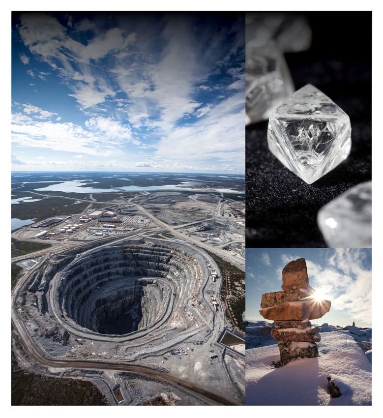
Table of Contents
Table of Contents .................................................................................................................................................................... 1
Introduction.............................................................................................................................................................................. 3
Executive Summary ................................................................................................................................................................ 3
Background ............................................................................................................................................................................. 4
General Information ................................................................................................................................................................ 5
   Company Identification ........................................................................................................................................................ 5
   Location ............................................................................................................................................................................... 5
   Site History .......................................................................................................................................................................... 8
Description of Current and Future Operations ........................................................................................................................ 8
Description of Mining Processes ........................................................................................................................................... 10
   Open Pit Mining ................................................................................................................................................................. 11
   Underground Mining .......................................................................................................................................................... 11
   Kimberlite Processing ........................................................................................................................................................ 12
Description of Mine Waste Management .............................................................................................................................. 13
   Long Lake Containment Facility ........................................................................................................................................ 14
   Beartooth Processed Kimberlite Containment Area .......................................................................................................... 17
   Sable Waste Rock Storage ............................................................................................................................................... 17
Description of Water and Effluent Management ................................................................................................................... 20
   Long Lake Containment Facility ........................................................................................................................................ 20
      Surface Minewater ......................................................................................................................................................... 21
      Panda, Koala North and Koala Pits ............................................................................................................................... 21
      Fox Site .......................................................................................................................................................................... 22
      Pigeon Site ..................................................................................................................................................................... 22
      Beartooth Pit .................................................................................................................................................................. 22
   Two Rock Sedimentation Pond ......................................................................................................................................... 23
Justification and Assessment of Alternatives ........................................................................................................................ 25
   Justification ........................................................................................................................................................................ 25
   Assessment of Alternatives ............................................................................................................................................... 25
Fish Habitat Compensation ................................................................................................................................................... 26
Record #: HSE RCD ENV 1493
Document Owner: Environment Department
Date: 20 March 2021
Template # EKA TEM 1852.13                                            Justification for the Use of Waters Frequented by Fish as Mine Waste Disposal Areas                                  1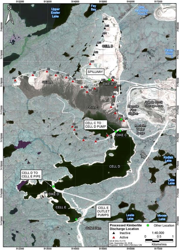
History and Context of Compensation Done to Date ........................................................................................................ 26
      Long Lake Cells D and E ............................................................................................................................................... 26
      Two Rock Sedimentation Pond ..................................................................................................................................... 26
   Description of Waterbodies to be Added to MDMER Schedule 2 ..................................................................................... 26
      Long Lake Cells D and E ............................................................................................................................................... 26
      Two Rock Sedimentation Pond ..................................................................................................................................... 27
   Previously Determined Quality of Fish Habitat .................................................................................................................. 27
      Long Lake Cells D and E ............................................................................................................................................... 27
      Two Rock Sedimentation Pond ..................................................................................................................................... 31
   Fish Habitat Compensation Proposed to be Used Under S.27.1 of the MDMER ............................................................. 33
      Long Lake Cells D and E ............................................................................................................................................... 33
      Two Rock Sedimentation Pond ..................................................................................................................................... 35
   Overall Costs Associated with Implemented or Planned Measures.................................................................................. 35
Conclusions ........................................................................................................................................................................... 36
References ............................................................................................................................................................................ 36

Record #: HSE RCD ENV 1493
Document Owner: Environment Department
Date: 20 March 2021
Template # EKA TEM 1852.13                                           Justification for the Use of Waters Frequented by Fish as Mine Waste Disposal Areas                                2
Introduction
This report was produced by Arctic Canadian Diamond Company Ltd (Arctic) for Environment and Climate Change
Canada (ECCC) in February 2021 to provide justification for the continued use of Long Lake Containment Facility (LLCF)
cells D and E, and Two Rock Sedimentation Pond (TRSP) as mine waste and/or effluent disposal areas (Tailings
Impoundment Area; TIA) under Schedule 2 of the Metal and Diamond Mining Effluent Regulations (MDMER). Contributing
authors were Laura Pacholski, Team Lead – Environmental Management and Monitoring; Harry O’Keefe, Superintendent
Environment; Kurtis Trefry, Environment Advisor – Projects and Closure Planning; and Claudine Lee, Head of
Environment.

Executive Summary
Following approval of the tailings management and construction plan for Long Lake, the LLCF has been successfully used
as a tailings management facility for over 20 years. Mine water from the Sable development has been successfully
managed using TRSP as a mine water management facility since early 2018. Through the Environmental Assessment
process, the LLCF and TRSP were identified and proposed as the most suitable options for mine water and waste
management and the review and approval of these waterbodies has already undergone rigorous scrutiny and public
review.

On June 1, 2018, the scope of the MDMER was expanded to include diamond mines. Following analysis of prior
information submitted by Arctic, ECCC with the assistance of Fisheries and Oceans Canada (DFO), determined that three
waterbodies at the Ekati Mine (i.e., LLCF cells D and E, and TRSP) are currently fish frequented and used to dispose of
mine waste. An amendment to Schedule 2 of the MDMER is required to authorize the continued use of these waterbodies
for mine waste disposal activities.

In order to proceed with a Schedule 2 amendment, and, subject to Governor in Council approval, application of the
Streamlining Policy to exempt the proposed listing from pre-publication in Part I of the Canada Gazette, ECCC requested
a document justifying the continued use of these three waterbodies to dispose of mine waste.

The purpose of this document is to provide the requested information to ECCC relating to LLCF cells D and E and TRSP
and serve as justification for the continued use of these fish-frequented waterbodies for the purposes of mine waste
management. This report provides information on the current and future operations at the Ekati Diamond Mine, mining
processes, mine waste and water management, justification for the continued use of the LLCF and TRSP under Schedule
2 of the MDMER, and information on the existing fish habitat compensation.

In conclusion, Arctic must keep using LLCF cells D and E and TRSP as TIAs. The inability to continue using these
waterbodies as TIAs would be detrimental to the continuation of mining at Ekati due to the associated impacts on
economic feasibility of the mine, lack of suitable alternatives, and potential environmental impacts to alternative
waterbodies that would need to be considered. Moreover, no additional compensation is required for LLCF cells D and E

Record #: HSE RCD ENV 1493
Document Owner: Environment Department
Date: 20 March 2021
Template # EKA TEM 1852.13                  Justification for the Use of Waters Frequented by Fish as Mine Waste Disposal Areas   3
and TRSP, as all the existing compensation under S.35 of the Fisheries Act meets the requirements of S.27.1 of the
MDMER and has already been completed as required by law in 1997.

Background
On June 1, 2018, the scope of the MDMER was expanded to include diamond mines. Following analysis of prior
information submitted by Arctic, ECCC with the assistance of Fisheries and Oceans Canada, determined that three
waterbodies at the Ekati Mine are currently fish frequented and used to dispose of mine waste. An amendment to
Schedule 2 of the MDMER is required to authorize the continued use of these waterbodies for mine waste disposal
activities.

The three waterbodies in question are as follows:

    •    Long Lake Containment Facility, Cell D;
    •    Long Lake Containment Facility, Cell E; and
    •    Two Rock Sedimentation Pond.

In order to proceed with a Schedule 2 amendment, and, subject to Governor in Council approval, application of the
Streamlining Policy to exempt the proposed listing from pre-publication in Part I of the Canada Gazette, ECCC requested
a document justifying the continued use of these three water bodies to dispose of mine waste. More specifically, the
information requested from Arctic and contained within this document is as follows:

    1. Confirmation of quantifiable fish habitat for Long Lake Cells D and E as well as TRSP; these values represent the
       pre-alteration state of the waterbodies before any mine related activities, i.e., usage for disposal of mining waste.
    2. A justification for the continued use of the three waterbodies for disposal of mine waste. This justification as well
       as related information would effectively satisfy the requirements of a typical Assessment of Alternatives report as
       well as a Fish Habitat Compensation Plan needed to authorize disposal of mine waste into a Tailings
       Impoundment Area listed in Schedule 2 of the MDMER. Considering that the Ekati mine has previously
       implemented offsetting measures under section 35 of the Fisheries Act for the destruction of fish habitat resulting
       from mine waste disposal activities at a time when diamond mines were not captured under the authorization
       scheme for mine waste disposal provided under section 5 of the MDMER, ECCC is of the view that this document
       would serve as adequate rationale to proceed with a Schedule 2 amendment. Key elements of this justification
       include:
            a. Rationale as to how the current and continued use of the three waterbodies for disposal of mine waste is
                 the most appropriate option from environmental, technical, and socio-economic perspectives.
            b. Description of the offsetting measures implemented to date under S.35 of the Fisheries Act and those to
                 be undertaken in the future, along with a justification as to how these measures compensate the use of
                 the waterbodies to be listed in Schedule 2 and the subsequent loss of fish habitat. Following receipt of
                 this information, ECCC will inform and engage potentially impacted Indigenous groups and stakeholders
                 on the proposed listing based on the associated document.

Record #: HSE RCD ENV 1493
Document Owner: Environment Department
Date: 20 March 2021
Template # EKA TEM 1852.13                    Justification for the Use of Waters Frequented by Fish as Mine Waste Disposal Areas   4
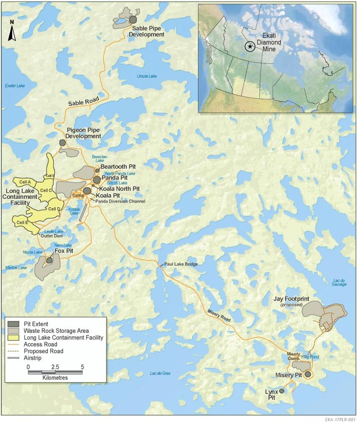
The purpose of this document is to provide the requested information to ECCC relating to LLCF cells D and E and TRSP
and serve as justification for the continued use of these fish-frequented waterbodies for the purposes of mine waste
management.

General Information

Company Identification
Arctic Canadian Diamond Company Ltd., 900-606 4 Street SW, Calgary, Alberta T2P 1T1

On 11 December 2020, the Alberta Court of Queen’s Bench approved the asset purchase agreement of Dominion
Diamond Mines by DDJ Capital Management, LLC and Brigade Capital Management, LP. Dominion has transferred its
assets to a new entity, known as the Arctic Canadian Diamond Company Ltd. From 1 February 2021, please address all
further communication regarding Schedule 2 of MDMER to the Arctic Canadian Diamond Company Ltd.

Location
The Ekati Diamond Mine is located approximately 200 km south of the Arctic Circle and 310 km northeast of Yellowknife,
NWT, Canada. See figures 1 and 2 below for reference. The mine is situated within the Lac de Gras watershed at the
headwaters of the Coppermine River drainage basin, which flows north to the Arctic Ocean. Located 100 km north of the
tree line on the Arctic tundra, the local terrain is characterized by boulder fields, tundra, wetlands, and numerous lakes
with interconnecting streams. There are more than 8,000 lakes within the claim block. It is an area of continuous
permafrost with a shallow active layer (less than 2 metres thick), which thaws during the brief summer.

Record #: HSE RCD ENV 1493
Document Owner: Environment Department
Date: 20 March 2021
Template # EKA TEM 1852.13                    Justification for the Use of Waters Frequented by Fish as Mine Waste Disposal Areas   5
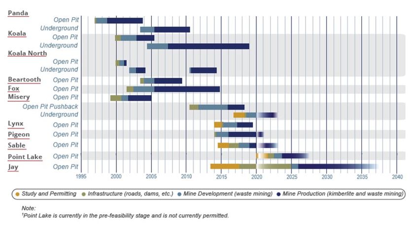
Figure 1: Location of Ekati Diamond Mine

Record #: HSE RCD ENV 1493
Document Owner: Environment Department
Date: 20 March 2021
Template # EKA TEM 1852.13                 Justification for the Use of Waters Frequented by Fish as Mine Waste Disposal Areas   6
Figure 2: Satellite Imagery of Ekati Diamond Mine

Record #: HSE RCD ENV 1493
Document Owner: Environment Department
Date: 20 March 2021
Template # EKA TEM 1852.13                Justification for the Use of Waters Frequented by Fish as Mine Waste Disposal Areas   7
Site History
On April 10, 2013, the Ekati mine was acquired from BHP Billiton Canada Inc. (and its various affiliates) all of BHP
Billiton’s diamond assets, including BHP Billiton’s controlling interest in the Ekati Diamond Mine.

The Ekati Diamond Mine consists of the Core Zone, which includes the current operating mine and other permitted
kimberlite pipes, as well as the Buffer Zone, an adjacent area hosting kimberlite pipes having both development and
exploration potential. The Company acquired BHP Billiton’s 80% interest in the Core Zone and 58.8% interest in the
Buffer Zone, with the remaining interests held by other joint venture parties.

The Ekati Diamond Mine officially began production in October 1998, following extensive exploration and development
work dating back to 1981. The company operates the Ekati Diamond Mine in which it owns a controlling interest. Over the
mine’s early years, production was focused on six open pits (Beartooth, Fox, Koala, Koala North, Misery, and Panda) and
three underground operations (Koala, Koala North, and Panda).

Mining activities are complete in seven kimberlite pipes (Panda, Beartooth, Fox, Koala, Koala North, Misery open pit, and
Lynx) and five remain as part of the planned mining activities to 2035 (Pigeon, Sable, and Jay open pits, and Misery
underground).

Description of Current and Future Operations
Scheduling of mine operations of the Ekati Diamond Mine is based on a variety of operational, economic, and business
factors, and is routinely reviewed and changed. A high-level summary of the mining activities per pit is provided below:

    •    Fox
            o Open pit operations ended in 2014
    •    Panda
            o Open pit operations have been completed
            o Underground operations have been completed and reclaimed
            o In-pit deposition of processed kimberlite is ongoing
    •    Koala North
            o Open pit operations have been completed, and the lower section of the pit has been reclaimed in
                preparation for pit flooding
            o Underground operations have been completed, and reclaimed in preparation for pit flooding
    •    Koala
            o Open pit operations have been completed and reclaimed
            o Underground operations were completed in 2018
            o Reclamation of the underground workings was completed in 2019
            o In-pit deposition of processed kimberlite is ongoing
    •    Beartooth

Record #: HSE RCD ENV 1493
Document Owner: Environment Department
Date: 20 March 2021
Template # EKA TEM 1852.13                    Justification for the Use of Waters Frequented by Fish as Mine Waste Disposal Areas   8
o Open pit operations have been completed
o In-pit deposition of processed kimberlite is ongoing
• Lynx
o Open pit operations have been completed
o The open pit is currently being utilized for water management from the King Pond Settling Facility
• Sable
o Open pit is in production scheduled to end in 2022
• Pigeon
o Open pit production commenced in 2015 and is scheduled to end in 2021
• Misery
o Open pit operations ended in 2018
o Misery underground is currently in production
• Point Lake
o Project permitting application scheduled to be submitted in 2021
• Jay
o Optimization study of the Jay Project is ongoing
Figure 3: Mine Plan
Record #: HSE RCD ENV 1493
Document Owner: Environment Department
Date: 20 March 2021
Template # EKA TEM 1852.13 Justification for the Use of Waters Frequented by Fish as Mine Waste Disposal Areas 9Description of Mining Processes The design-rated capacity for the Ekati Diamond Mine is 5,664,000 tonnes per year. The design-rated capacity was determined by calculating the maximum daily ore throughput from the last five years of operation (16,000 tonnes) and multiplying by the amount of days the Process Plant operates each year (354 days). The design-rated capacity is limited by assurance metrics which ensure safe, responsible and efficient operation. Minewater is defined in Water Licence W2012L2-0001 as: “Minewater includes runoff from facilities associated with the Project and all water or Waste pumped or flowing out of any open pit or underground mine.” Minewater must meet the effluent quality criteria specified in Part H of Water Licence W2012L2-0001 and the MDMER on the concentration of deleterious substances, pH and ensure that the effluent is not acutely lethal prior to release to a Receiving Environment. This is achieved by directing Minewater to several centralized Minewater management facilities at Ekati, where the collected waters are analyzed and demonstrated compliant prior to Discharge. Long Lake cells D and E, and the TRSP are two such Minewater management facilities. Processed kimberlite is defined in Water Licence W2012L2-0001 as: “Processed Kimberlite means material rejected from the process plant after the recoverable diamonds have been extracted.” Processed kimberlite generated from processing encompasses two fractions: 1. Coarse Processed Kimberlite is the fraction of kimberlite typically greater than 0.5 mm in diameter and is trucked to the southwest area of the Panda/Koala WRSA. 2. Fine processed kimberlite is the fraction of kimberlite typically smaller than 0.5 mm in diameter and is transported by pipeline as a slurry to an authorized Processed Kimberlite Containment Area (PKCA), currently the LLCF, Beartooth Pit, and Panda/Koala/Koala North open pits and associated underground workings. Water is used in the processing of kimberlite as a means of dust control and as part of the gravitational separation process. The extraction of diamonds is a physical process rather than a chemical process, which is why water is required to control dust and assist with gravitational segregation of kimberlite as it moves through the various stages of processing. Water from underground mining comes from inflow sources of groundwater that are required to be removed from the mining area, and water is also used in underground mining for dust control during drilling operations. Management of water that is used within and released from the diamond separation process in the Process Plant is described as part of the management of fine processed kimberlite. Please refer to the Wastewater and Processed Kimberlite Management Plan for more information on wastewater and processed kimberlite management at the Ekati Diamond Mine (Dominion 2019). Record #: HSE RCD ENV 1493 Document Owner: Environment Department Date: 20 March 2021 Template # EKA TEM 1852.13 Justification for the Use of Waters Frequented by Fish as Mine Waste Disposal Areas 10
Open Pit Mining
Prior to mining, each of the kimberlite pipes was covered by a lake which was subsequently drained to allow mining
development. Where possible, lake sediments, glacial sediments and topsoil were removed and stored for possible use
during reclamation. The current topography and geomorphology reflect a mined and natural landscape with waste rock
storage areas, pit developments and infrastructure surrounded by tundra.

The method of open pit mining is similar for all of the open pits at the Ekati mine. All of the kimberlite pipes, with the
exception of Pigeon, are located under lakes which require dewatering prior to mining. The Pigeon pipe was located on
rolling moraine that was partially covered by a small pond.

For the developments to date, each lake was fished out prior to development by a combination of Indigenous fishers and
fisheries biologists/technicians, and the fish were either distributed to local communities or transferred to other nearby
waterbodies. The lakes were then drained of water, and overburden (lake sediments and glacial till) was removed. Fish
habitat lost through the removal of these lakes has been compensated for (or offset) through Fisheries Act Authorizations.

In comparison to other types of ore deposits, kimberlite pipes are very regular and contacts between kimberlite and the
host rock are readily defined. The Ekati mine kimberlite pipes are roughly circular in plan view and lie within competent
host rocks. The ore-waste boundary is structural and easily defined on rock type. The kimberlite pipes at the Ekati mine
have distinct physical characteristics—they are predominantly carrot shaped—that result in a high stripping ratio, which in
turn must be met with a high-capacity materials handling fleet.

The first step in open pit mining is to remove the overburden material, which at the Ekati mine includes beach areas and
tundra, lake sediments, and glacial till that lie within the designed pit perimeter. The removal of surface till, waste rock,
waste kimberlite, and kimberlite ore require the use of explosives and standard truck and shovel techniques.

Excavated rock is loaded into haul trucks with a 90- to 225-tonne capacity and is transported to Waste Rock Storage
Areas (WRSA), to temporary ore storage locations, or to the processing plant.

The design of open pits is similar for all pits at the Ekati mine. Single, double, or triple benches (typically 10 m) are used
depending on geological conditions. The majority of the open final pit slopes are or are planned to be within granite,
diabase, or metasediment host rock (i.e., and not in kimberlite).

Underground Mining
Underground mining has been undertaken below Panda, Koala North, and Koala pits, and Misery Pit. Koala Underground
is currently in production. The process of underground mining to date starts with access development, which involves
blasting and excavating tunnels—known as declines—through the granite bedrock to the kimberlite pipe. Typically, an
underground ramp leading progressively to the top section of the underground kimberlite is constructed as a spiral.
Deeper kimberlite sections are accessed by blasting spiral-shaped declines in the bedrock adjacent to the kimberlite pipe.

Record #: HSE RCD ENV 1493
Document Owner: Environment Department
Date: 20 March 2021
Template # EKA TEM 1852.13                     Justification for the Use of Waters Frequented by Fish as Mine Waste Disposal Areas   11
The ore is excavated by cutting horizontally into the kimberlite pipes from the spiral ramps. Ore is transported from the
underground developments by a combination of specialized underground haul trucks and conveyors.

Kimberlite ore from the Panda and Koala pipes is extracted from underground using sublevel retreat and sublevel cave
methods, respectively. The extraction from Misery pipe will be done using sublevel retreat methods. Sublevel retreat and
sublevel caving mining methods are “top down” techniques for regularly shaped ore bodies with weak to strong ore. The
ore is drilled and blasted in rings called upholes from multiple drill drifts on each sublevel and extracted in a controlled
manner. Production then continues from successive lower sublevels in the kimberlite pipe. The sublevel retreat method is
commenced from directly beneath the depleted open pit, while the sublevel cave method is started from beneath a block
of low-grade kimberlite. The low-grade kimberlite will be allowed to cave in a controlled manner as the higher value ore is
extracted. Both sublevel retreat and sublevel cave are recognized and well-documented mining methods. With the
sublevel retreat method, a relatively small portion of the ore is left in the stope to reduce the requirement for remote-
controlled extraction and to provide a measure of protection for personnel and equipment from waste rock failures in the
pipe/pit walls above the active workings, as well as to control ventilation through the draw points. With sublevel caving, the
cave material performs this function. At the conclusion of mining, the amount of ore removed is essentially the same for
both mining methods.

A connecting underground conveyor system from Koala Underground to Panda Underground was commissioned in late
2007. A 2.4 km long conveyor system (commissioned in 2006) transports kimberlite from the Panda Underground crusher
to the ore storage area at the processing plant. The movement of ore on these conveyor systems is monitored from a
control room at the surface.

Due to the close proximity of the Panda, Koala, and Koala North underground operations, a common access decline to
the undergrounds was developed through the Koala North Portal. Ventilation shafts have been sunk to ensure ventilation
to all areas of the underground. Other facilities that are wholly underground include an underground maintenance shop,
lunch rooms, refuge chambers in case of emergency, and sizing facilities to regulate ore fragmentation size on the
conveyor system.

Underground mines require extensive ventilation, dewatering systems, and carefully developed safety and emergency
response procedures. Safe areas with independent air supply are located in each of the Panda, Koala North, and Koala
underground workings to provide refuge for workers in case of a fire or explosion. Communication systems are also in
place to warn workers of potential hazards, and specially trained emergency response teams are always on standby.

Kimberlite Processing
Diamond-bearing kimberlite extracted from the open pit and underground mining operations is processed at a single,
centralized processing plant, located within the permanent Ekati main camp, southwest of Koala Pit.

Physical separation of diamonds from kimberlite requires grinding and washing at the processing plant. The primary
crusher reduces ore to a maximum size of 300 mm, and then a water-flushed cone crusher reduces the coarse ore to 75
mm. A high-pressure grinding roll is used to crush kimberlite to liberate diamonds and break ore down to a maximum top
size of 25 mm. Flocculants and coagulants are added to aid in settling of the fine processed kimberlite fractions. Heavy
Record #: HSE RCD ENV 1493
Document Owner: Environment Department
Date: 20 March 2021
Template # EKA TEM 1852.13                     Justification for the Use of Waters Frequented by Fish as Mine Waste Disposal Areas   12
medium separation using a slurry of water and ferrosilicon is used to separate a heavy mineral concentrate from the
crushed ore. X-ray sorters are used to extract diamonds from the heavy medium separation concentrate because
diamonds luminesce when X-rayed.

The coarse fraction (sand size greater than 0.65 mm) is referred to as coarse rejects, or coarse processed kimberlite, and
is trucked to the coarse kimberlite rejects storage area located adjacent to the processing plant. The fine fraction (fine
processed kimberlite; fine sand, silt and clay less than 0.65 mm) is sent to the processed kimberlite containment areas by
slurry pipeline at an approximate daily volume of 13,000 m3 (including solids and slurry).

Description of Mine Waste Management
Waste materials from open pit and underground mining are placed in waste rock storage areas (WRSAs) located adjacent
to open pit operations. The WRSAs also contain and store other materials including coarse kimberlite rejects, kimberlite
stockpiles, lake sediments, glacial tills and landfill material. Salvage topsoil as well as co-mixed lake sediments/glacial till
have also been stockpiled adjacent to WRSAs. There are currently six separate WRSAs constructed at the Ekati mine
(Panda/Koala/Beartooth, Pigeon, Fox, Misery, Lynx and Sable).

The WRSAs at the Ekati mine are all designed and constructed to meet the following primary objectives:

    •    To be inherently physically stable structures, both during mine operations and in the long term;
    •    Designed as permanent structures to remain after mining is completed;
    •    Constructed to promote permafrost aggradation; and
    •    Designed to achieve reasonable balance between surface footprint and height, with 50 m the target height.

Waste Rock Storage Areas at the Ekati mine are constructed to minimize the risk of runoff originating from them and to
encourage permafrost formation. As the Ekati mine is located within the climate zone of continuous permafrost, water
infiltrating the WRSAs becomes trapped in the waste rock as ice when it encounters sub-freezing internal temperatures.
Leaching from waste rock is thus limited to the outer surface of the waste rock (active layer) where water produced by
melting of seasonal surficial ice and snow runs over the trapped ice surface.

The following is a list of generic features that are incorporated into the design of WRSAs at the Ekati mine:

    •    Construction of a basal layer of granitic waste rock over the tundra, prior to construction of the WRSA. This allows
         early aggradation of permafrost into the base of the waste rock and limits contact of potentially reactive waste
         rock with surface flow over tundra soils, which can be naturally acidic;
    •    Encapsulation of potentially reactive materials (e.g. metasediment) within a thermally protective and
         geochemically non-reactive cover such that the potentially reactive materials remain at freezing conditions,
         thereby ensuring stable storage over time;
    •    Use of rock with low reactivity in zones expected to be subject to seasonal thawing (i.e. the active layer of the
         piles is intentionally constructed with a granite/diabase or glacial till cap);
    •    Construction of toe berms in selected areas where appropriate (i.e. drainage gullies) to limit runoff of water from
         the waste rock; and
Record #: HSE RCD ENV 1493
Document Owner: Environment Department
Date: 20 March 2021
Template # EKA TEM 1852.13                     Justification for the Use of Waters Frequented by Fish as Mine Waste Disposal Areas   13
• Setbacks from the receiving waterbodies as a mitigation measure to allow for attenuation of drainage by tundra
soils and contingencies such as construction of frozen toe berms, and water collection structures.
Application of the above features depends on the specific geochemical characteristics of the waste rock in combination
with site-specific considerations such as topographical features and proximity to the aquatic Receiving Environment.
For more information on the quantity of waste rock removed from each pipe and the general design criteria of the WRSAs,
please refer to the latest version of the Waste Rock and Ore Storage Management Plan available on the Wek’èezhìi Land
and Water Board’s public registry.
There is currently one active processed kimberlite containment area for deposition of processed kimberlite at the Ekati
mine; the LLCF. The Phase 1 processed kimberlite containment area was part of the original kimberlite bulk sample
processing conducted at Old Camp and has not been in operation since 2002. The area has since undergone progressive
reclamation.
In addition to active deposition in the LLCF, processed kimberlite can also be deposited and stored in open pits. Mining at
Beartooth Pit was completed in April 2009, and beginning in 2013, fine processed kimberlite was deposited into the pit via
the Beartooth slurry pipeline. Beartooth Pit continues to operate as a processed kimberlite containment area and water
management facility. The mined-out Panda and Koala pits are used for processed kimberlite deposition beginning in 2019
after the completion of mining and decommissioning activities in the Koala Underground.
Long Lake Containment Facility
The LLCF encompasses Long Lake and the former headwater lakes of Long Lake (Figure 4). The LLCF is at the
headwater of the western Koala Watershed, which feeds into the Lac de Gras watershed (Figure 1).
The LLCF currently includes the following components:
• Cells — A, B, C, D, and E. Cells A and C of the LLCF will continue to be available as active fine processed
kimberlite deposition locations until they reach their final designed capacity limits. Cell B is no longer receiving
fine processed kimberlite. Cell D is licensed to store processed kimberlite, but no deposition has occurred to date;
instead, Cell D is used as a Minewater management and reclaim water pond. Cell D will serve as a contingency
processed kimberlite deposition area throughout mine operations. Cell E provides surge water storage capacity
for surplus water and acts as a finishing pond prior to pumped Discharge to the Receiving Environment. Cell E will
not receive fine processed kimberlite.
• Dikes — B, C, and D (designation corresponds to upstream subtended cell). These filter dikes are designed to
retain processed kimberlite solids within the upstream cell but allow water to filter through to the downstream cell.
Dike B is considered to be effectively sealed (as anticipated) and water transfer from Cell B to C flows through a
culvert. Dike C is considered to be partially sealed and water transfer from Cell C to D is augmented by pumping.
Dike D is not affected by processed kimberlite but water transfer from Cell D to E is augmented by pumping as
required to safely manage pond water levels.
Record #: HSE RCD ENV 1493
Document Owner: Environment Department
Date: 20 March 2021
Template # EKA TEM 1852.13 Justification for the Use of Waters Frequented by Fish as Mine Waste Disposal Areas 14• Dams — The Outlet Dam serves as the downstream water control structure at the outlet of Cell E which retains
water until sampled, authorized and pumped to the Receiving Environment. Water levels are maintained with
minimum 1.0 m freeboard and in accordance with the current Water Licence.
• Water Pumps — Pumps on the upstream side of Dike C are used to pump water from Cell C to the reclaim barge
in Cell D. The reclaim water barge in Cell D pumps water to the processing plant. In 2017, a weir was installed on
Dike D to control the flow of water from Cell D to Cell E (this has replaced a previously installed diesel-powered
pump). Pumps in Cell E transfer water that meets the current Water Licence (W2012L2-0001) effluent quality
criteria into Leslie Lake (at SNP Station 1616-30). Pumping rates into Leslie Lake are up to 2.55 m3/s from 1 May
to 31 July, and 0.52 m3 per second at other times (approximately 6 to 8 million m3 annually).
• Access Roads — Roads are located along the north side of Cell A, around the perimeter of Cell B; along the east,
west, and south sides of Cell C; and along the east side of Cells D and E. The Fox Pit road extends from the
processing plant to the outlet dam across the Outlet Dam.
• Powerlines, pipelines, and Discharge spigots — Pipelines are used for the delivery of the fine processed
kimberlite slurry along the access roads from the Process Plant site. These run along the east, west, and north
side of Cell C, and the north side of Cell A. Electric pumps are used to pump the water from Cell E to Leslie to
reduce environmental risks associated with diesel pumps.
Record #: HSE RCD ENV 1493
Document Owner: Environment Department
Date: 20 March 2021
Template # EKA TEM 1852.13 Justification for the Use of Waters Frequented by Fish as Mine Waste Disposal Areas 15Figure 4: Long Lake Containment Facility Record #: HSE RCD ENV 1493 Document Owner: Environment Department Date: 20 March 2021 Template # EKA TEM 1852.13 Justification for the Use of Waters Frequented by Fish as Mine Waste Disposal Areas 16
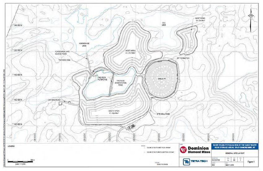
Beartooth Processed Kimberlite Containment Area
Beartooth Pit is a relatively smaller sized open pit located approximately 3 km from the Process Plant to the north of and
adjacent to Panda Pit. Mining operations in Beartooth Pit ceased permanently in 2009. Since 2009, the mined-out pit has
been used as a Minewater retention pond at times when it is beneficial to divert certain waste water sources away from
the LLCF. Fine processed kimberlite has been deposited into Beartooth Pit via slurry pipeline on an intermittent basis
since February 2013.

Beginning in 2009, various sources of Minewater have been directed to the mined-out Beartooth Pit (subsequently
Beartooth Processed Kimberlite Containment Area) including from the Ammonium Nitrate Storage Facility sumps, Polar
Explosives sump and underground Minewater from Panda and Koala. The diversion of this water away from the LLCF
was initially part of Arctic’s adaptive management response to elevated nitrate concentrations in the LLCF water and to
the risk of future elevated chloride concentrations in the LLCF water. These measures continue to be used to reduce
potential effects in the Receiving Environment downstream of the LLCF.

Excess Minewater, precipitation and runoff that accumulates in the pit is pumped to the LLCF (Cell C) on an as-needed
basis, typically seasonally during the summer. The pumped water mixes with other waters in the LLCF and forms part of
the Discharge from Cell E of the LLCF to the Receiving Environment, Leslie Lake.

Sable Waste Rock Storage
95% of the waste rock excavated from Sable Pit will be granite. Granite rock has been demonstrated and accepted over
the past 15 years of operations at the Ekati mine as non-acid generating and non-metal leaching. To verify the results of
the samples collected during the geochemical characterization, waste rock sampling will be conducted at Sable pit for two
years at a rate of three samples per rock type per bench per year. After two years, the need for further waste rock
sampling will be evaluated based on results.

There are three parts to the Sable WRSA (Figure 5): The West WRSA is located northwest of the proposed Sable Pit and
the South WRSA is located southwest of the proposed Sable Pit and wraps around the west side of TRSP. The East
WRSA is located northeast of Sable Pit. Directly south of the West WRSA and north of the South WRSA is TRSP. The
South WRSA is a roughly rectangular shaped pile approximately 1,400 m long and 600 m wide. It will have a final volume
of approximately 25.4 Mm3 and a final design elevation of 563 metres above sea level (MASL). The West WRSA is an
irregularly shaped pile that is approximately 1,200 m at the greatest length and 1,100 m at the greatest width. It will have a
final volume of approximately 23.2 Mm3 and a final design elevation of 550 MASL. The East WRSA is a roughly
rectangular shaped pile approximately 650 m in length and 500 m in width. It will have a final volume of approximately 3.4
Mm3 and a final design elevation of 535 MASL.

Arctic will not place rock in the East WRSA unless contingency volume is required, or operational conditions are such that
the rock must be placed in the East WRSA. The pile will be constructed in bench lifts of 15 m height with steps every lift to

Record #: HSE RCD ENV 1493
Document Owner: Environment Department
Date: 20 March 2021
Template # EKA TEM 1852.13                     Justification for the Use of Waters Frequented by Fish as Mine Waste Disposal Areas   17
meet the final wall angle that will vary depending on the storage area. Toe berms will not be constructed unless deemed
necessary based on results of the seepage monitoring program and adaptive management practices.

Record #: HSE RCD ENV 1493
Document Owner: Environment Department
Date: 20 March 2021
Template # EKA TEM 1852.13                   Justification for the Use of Waters Frequented by Fish as Mine Waste Disposal Areas   18
Figure 5: Sable Waste Rock Storage Areas

Record #: HSE RCD ENV 1493
Document Owner: Environment Department
Date: 20 March 2021
Template # EKA TEM 1852.13               Justification for the Use of Waters Frequented by Fish as Mine Waste Disposal Areas   19
Description of Water and Effluent Management

Long Lake Containment Facility
The LLCF has been in operation since 1998 and was designed to safely contain processed kimberlite and to provide
acceptable water quality and quantity according to operating and environmental protection requirements. Processed
kimberlite is separated at the processing plant and the fine fraction (defined as material less than 0.5 mm in diameter,
classed as fine sand, silt, and clay) is sent to the LLCF as a slurry by pipeline. The components of the LLCF include
containment Cells A, B, C, D, and E; filter Dikes B, C, and D; the Outlet Dam; water pumps; access roads; and pipelines,
spigots, and power lines (Figure 4). The UTM (Universal Transverse Mercator) coordinates for the centre point of cells D
and E are Zone 12N E515141; N7174873 and E513397; N7173874, respectively.

A Reclaim Water Barge is located at the north end of Cell D, which pumps water from Cell D to the Process Plant. The
reclaim barge is located in Cell D to provide adequate quality (i.e., clarity) and quantity of water (about 4.5 M m3 annually)
for diamond processing. Water is syphoned or pumped from Cell C to the intake of the reclaim barge. In order to contain
water within the LLCF watershed the maximum level in Cell D has been set to 449.3 m. Pipes have been installed to
convey water from Cell D to Cell E. Pumps located on Dike D pump water over the dike into Cell E to augment dike
seepage when desired to manage Discharge from Cell E or to maintain desired water levels in Cell D. The Reclaim Water
Barge has been designed such that ideal water level in Cell D is 448 m and the minimum water level should be 447 m.

Cell E is used as a final polishing pond where water quality can be monitored and water levels can be controlled. During
operations, the Discharge of Cell E water is controlled by the Outlet Dam, a frozen core dam. Water is only Discharged to
the downstream Receiving Environment when it meets the water quality requirements specified in the current Water
Licence (W2012L2-0001). Pumping rates are up to 2.55 m3 per second from 1 May to 31 July, and 0.52 m3 per second at
other times. The water level is generally maintained less than or equal to Cell D with a maximum level of 449.3 m.

Operational water quality monitoring is conducted within Cell E of the LLCF at SNP Station 1616-30. Water quality is also
monitored at Leslie Lake and other lakes downstream of the LLCF. Indicators measured are water quality, sediment
quality, physical limnology, phytoplankton, zooplankton, and lake benthos. Details on the monitoring methods and results
are found in Aquatic Effects Monitoring Program annual reports.

Monthly water levels for Cell E, summary of process water use in the LLCF, water pumped to the LLCF, Discharge
volumes from the LLCF, summary of treated sewage effluents to the LLCF, and Discharge water quality are reported in
monthly SNP reports and the Water Licence and Environmental Agreement annual reports. Additional detail on the
operational aspects of water volumes and management can also be found in the Wastewater and Processed Kimberlite
Management Plan.

The basis of the current LLCF processed kimberlite deposition plan was established through a comprehensive review of
the LLCF development plan in 2005 and an evaluation of deposition completed in 2011. The selected deposition plan
maximized the utilization of storage capacity in Cells A, B, and C in favour of deferring or avoiding processed kimberlite
deposition into Cell D through the formation of beaches in Cells A, B, and C. Deposition into Cells A and C of the LLCF
Record #: HSE RCD ENV 1493
Document Owner: Environment Department
Date: 20 March 2021
Template # EKA TEM 1852.13                     Justification for the Use of Waters Frequented by Fish as Mine Waste Disposal Areas   20
will continue until the remaining current storage capacity for solids is exhausted (i.e., the remaining FPK storage capacity
within the LLCF is 34 Mm3 [Dominion 2019]; however deposition is currently directed to Panda and Koala pits). During
processed kimberlite deposition into Panda/Koala Pit, the LLCF will be utilized to manage Minewater decanted from the
pits. Additionally, the LLCF will be utilized to pump flood Fox Pit.

Surface Minewater

Management methods for surface Minewater from all current and planned future operations are described below. Surface
Minewater is collected from the following locations:

    •    Ekati Main Camp and Pit Areas; snowmelt and rainwater runoff from areas with high vehicular traffic are collected
         into a containment sump lined with geo-membranes to minimize seepage losses. The collected water is pumped
         or trucked to the LLCF or otherwise directed to an interim storage location such as the Beartooth or Panda/Koala
         processed kimberlite containment areas.
    •    Landfarm; water from precipitation (rain/snowmelt): is contained within a plastic liner prior to trucking to the LLCF
         or an interim storage location such as the Beartooth or Panda/Koala processed kimberlite containment areas.
    •    Contaminated Snow and Ice Containment Facility; hydrocarbon impacted snow and ice from winter spill
         remediation activities is collected in this facility as per the Spill Contingency Plan. The spring melt water is
         collected in the lined sump and free-phase hydrocarbons are recovered by skimming activities before water is
         trucked to the LLCF or an interim storage location such as the Beartooth or Panda/Koala processed kimberlite
         containment areas.
    •    Various Buildings; wastewater collected from various buildings includes wastewater from truck washing
         operations, maintenance shops wastewater (e.g., floor washing and general maintenance) that is collected in
         internal concrete sumps and trucked to the LLCF or an interim storage location such as the Beartooth or
         Panda/Koala processed kimberlite containment areas.
    •    Scrubbers; the incinerator building is equipped with two wet scrubbers to reduce emissions; collected water is
         trucked to the LLCF or an interim storage location such as the Beartooth or Panda/Koala processed kimberlite
         containment areas.
    •    Containment Berms; fuel bulk storage and transfer locations collect rainwater and snowmelt within lined sumps.
         The spring melt water is collected, and free-phase hydrocarbons are recovered by skimming activities before
         water is trucked to the LLCF or an interim storage location such as the Beartooth or Panda/Koala processed
         kimberlite containment areas.
    •    Fresh Air Raise Containment Berms; located at the Panda/Koala underground mines produce wastewater that is
         taken to the LLCF.
    •    The concrete sumps around the Ammonia Nitrate Storage Facility and the Polar Explosives Building collect
         surface water which is collected by truck and deposited into the LLCF, the Beartooth Processed Kimberlite
         Containment Area or the Panda and Koala Processed Kimberlite Containment Area.

Panda, Koala North and Koala Pits

The lower levels of the Panda, Koala North and Koala open pits were hydraulically open to the underlying underground
workings (i.e., prior to processed kimberlite deposition). Following commencement of deposition, the pits, including
contained Minewater, are managed as an active processed kimberlite containment area. Excess Minewater that
accumulates in the processed kimberlite containment area is pumped to the LLCF or to the Process Plant on an as-
needed basis.

Record #: HSE RCD ENV 1493
Document Owner: Environment Department
Date: 20 March 2021
Template # EKA TEM 1852.13                     Justification for the Use of Waters Frequented by Fish as Mine Waste Disposal Areas   21
Fox Site Open pit mining of the Fox kimberlite was completed in 2014 and, since that time, local area runoff (including surface Minewater) enters and accumulates within the pit. During the previous period of open pit mining, most drainage and runoff that flows toward the Fox Pit was captured before it reached the pit by surface diversion ditches and sumps. Once captured, the water was then pumped by a pipeline to Cell C of the LLCF or released to the tundra (with Inspector authorization). An in-line flocculant treatment plant is in place in the LLCF pipeline to be utilized if necessary to aid in settlement of suspended sediment in water pumped to the LLCF. This has not been necessary and has not been utilized since early in Fox pit dewatering activities and remains in place as a contingency only. The operational surface Minewater management pipelines and sumps remain in place pending future consideration of mining the deeper portions of the Fox kimberlite. Pigeon Site Surface Minewater within the Pigeon Pit area is contained within the water deflection berms located between the northern edge of the Pigeon Pit area and Pigeon Stream and is directed into the surface sumps or managed as open pit water. Once captured, the water is moved by pipeline or by truck to the LLCF, Beartooth Processed Kimberlite Containment Area or Panda/Koala. Beartooth Pit Prior to 2009, water was pumped or trucked out of the Beartooth Pit to the LLCF. Mining operations ceased in 2009 and, since that time, the Beartooth pit has been used for retention of Minewater that was enriched in nitrate and/or chloride. This was initiated as an adaptive management response to enhance the protection of the environment downstream of the LLCF. Underground Minewater, surface Minewater from the ammonium nitrate storage facility sumps, and other Minewater has been directed to the Beartooth Pit since 2009. This practice will continue on an adaptive management basis as needed. Use of the Beartooth Pit as a processed kimberlite containment area was approved by the Wek’èezhìi Land and Water Board in 2012 and since that time fine processed kimberlite has been deposited into the Beartooth Processed Kimberlite Containment Area via slurry pipeline on an intermittent basis. Excess Minewater that accumulates is pumped to the LLCF or the Panda Pit, on an as-needed basis, typically seasonally during the summer. Record #: HSE RCD ENV 1493 Document Owner: Environment Department Date: 20 March 2021 Template # EKA TEM 1852.13 Justification for the Use of Waters Frequented by Fish as Mine Waste Disposal Areas 22
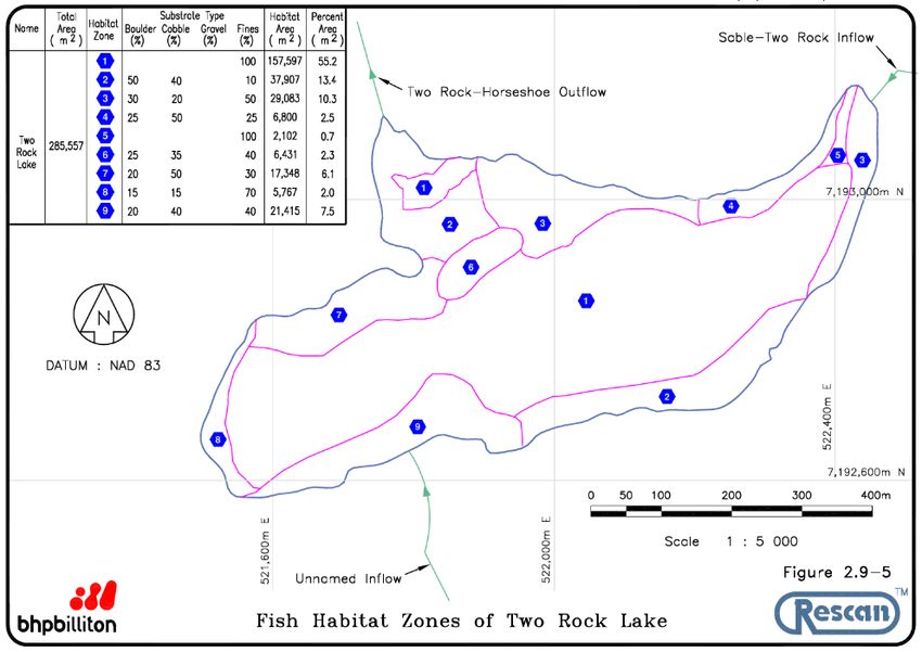
Two Rock Sedimentation Pond
Two Rock Sedimentation Pond is used to manage Minewater from Sable Pit and seepage from the Sable WRSA. Open
pit Minewater from Sable Pit is collected in the pit and moved by pipeline or truck to the upstream cell of TRSP where
suspended sediments settle and filter from the water that seeps through the filter dike to the downstream cell. The
sediment capacity of TRSP is anticipated to be adequate for the duration of the open pit operations without interim
excavation. The functioning of TRSP is monitored during operations and excess sediment in the upstream cell may be
excavated if necessary to ensure effective settling of sediment.

The UTM (Universal Transverse Mercator) coordinates for the centre point of TRSP are Zone 12N E521990; N7192840
(Figure 5). The water storage capacity for TRSP is 887,000 m3, which equates to a three-year storage capacity (Dominion
2021). A filter dike was constructed in 2017 to divide TRSP into two cells (upstream and downstream). The dike was
constructed with waste rock and a sand, gravel silt filter blanket to filter suspended sediments from the water as it moves
from the upstream cell to the downstream cell.

Two Rock Dam was constructed in 2017 at the outlet of Two Rock Lake to contain TRSP and consists of frozen sand and
gravel core water retention dam, protected by crushed transition rock and covered with granite on a permafrost
foundation.

During the mine life, the key water inflows to TRSP include: runoff from natural catchments surrounding lakes, rainfall,
runoff from the WRSAs, and water pumped from Sable Pit. The Sable Pit sump water will be pumped to the upstream cell
of TRSP for passive processing. The sources of Sable Pit sump water include surface runoff, precipitation, and
groundwater infiltration into the open pit. Potable water and wastewater will be hauled to and from the main mine site.

Two Rock Sedimentation Pond at the Sable site manages Discharge to Horseshoe Lake in the Horseshoe watershed. Per
Condition H.29 of the Water Licence, the annual volumes of Discharge from TRSP shall not exceed 740,600 m3 during
the operations phase.

Record #: HSE RCD ENV 1493
Document Owner: Environment Department
Date: 20 March 2021
Template # EKA TEM 1852.13                    Justification for the Use of Waters Frequented by Fish as Mine Waste Disposal Areas   23
Figure 5: Two Rock Sedimentation Pond

Record #: HSE RCD ENV 1493
Document Owner: Environment Department
Date: 20 March 2021
Template # EKA TEM 1852.13               Justification for the Use of Waters Frequented by Fish as Mine Waste Disposal Areas   24
Justification and Assessment of Alternatives

Justification
The use of Long Lake and the individual cells of Long Lake (i.e., cells A, B, C, D, and E) were proposed in the 1995
Environmental Impact Statement Report and supporting information in the Tailings Management Plan and Preliminary
Design of Retention Structures (BHP Billiton 1995). This proposed approach to tailings management was extensively
reviewed as part of the Environmental Assessment in 1996. Following approval of the tailings management and
construction plan for Long Lake, the LLCF has been successfully used as a tailings management facility for over 20 years.
Similarly, TRSP was included in the Environmental Assessment for the Sable, Pigeon, and Beartooth kimberlite pipes in
2000 (BHP and Dia Met 2000) and dewatering described in the Sable Lake and Two Rock Sedimentation Pond
Dewatering Plan in 2017 (DDEC 2017). Mine water from the Sable development has been successfully managed using
TRSP as a mine water management facility since early 2018.

Through the Environmental Assessment process, the LLCF and TRSP were identified and proposed as the most suitable
options for mine water management, as has been demonstrated through their successful operational use to date. The
inability to continue using these waterbodies as TIAs would be detrimental to the continuation of mining at Ekati due to the
associated impacts on economic feasibility of the mine, lack of suitable alternatives, and potential environmental impacts
to alternative waterbodies that would need to be considered, etc. In addition, the review and approval of these
waterbodies has already undergone rigorous scrutiny and public review, with no demonstrated benefits of undergoing
additional repetitive, time consuming, and costly review as part of the MDMER.

Assessment of Alternatives
The Environmental Assessments for which both mine water and waste management facilities were proposed (i.e., Long
Lake and Two Rock Lake), were conducted in accordance with regulatory guidance over 20 years ago and considered the
environmental, technical, economic, and socio-economical aspects. At that time, the most appropriate options for mine
water and waste management were proposed based on proximity to the operational facilities (i.e., Process Plant, open pit
mine), suitability for the operational needs (e.g., capacity), and the potential for effectively managing environmental
effects. There are no appropriate alternatives that meet all these requirements as closely as the current TIAs or that have
the operational data demonstrating successful use.

Record #: HSE RCD ENV 1493
Document Owner: Environment Department
Date: 20 March 2021
Template # EKA TEM 1852.13                    Justification for the Use of Waters Frequented by Fish as Mine Waste Disposal Areas   25
You can also read