Localizing Hazard Mitigation: Recommendations for Westport's Comprehensive Plan Update Workshop Documentation Appendix | URBDP 508B Autumn 2018
←
→
Page content transcription
If your browser does not render page correctly, please read the page content below
Localizing Hazard Mitigation: Recommendations for Westport’s Comprehensive Plan Update
                              Workshop Documentation Appendix | URBDP 508B Autumn 2018

1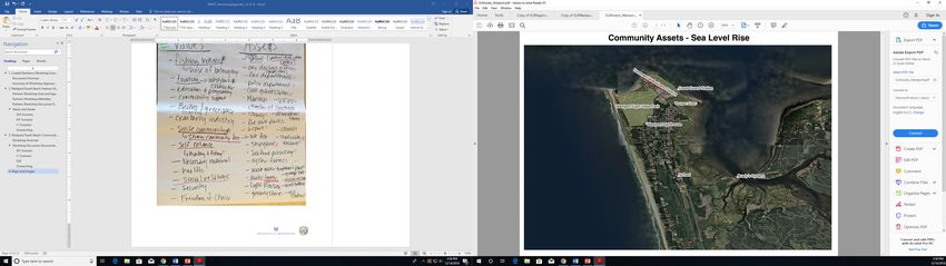
Localizing Hazard Mitigation: Recommendations for Westport’s Comprehensive Plan Update
                                                                          Workshop Documentation Appendix | URBDP 508B Autumn 2018

Table of Contents
TABLE OF CONTENTS ............................................................................................................................................. I
LIST OF TABLES ..................................................................................................................................................... I
LIST OF FIGURES................................................................................................................................................... II
1.      COASTAL RESILIENCE WORKSHOP SUMMARY .............................................................................................. 1
     1.1. DOCUMENT OVERVIEW ............................................................................................................................................1
     1.2. SUMMARY OF WORKSHOP APPROACH AND OUTCOMES .................................................................................................1
        1.2.1.Values and Assets ........................................................................................................................................2
        1.2.2. Hazards Scenarios .......................................................................................................................................3
2.      WESTPORT/SOUTH BEACH PARTNERS COASTAL RESILIENCE WORKSHOP DOCUMENTATION..................... 20
     2.1. PARTNERS WORKSHOP GOAL AND AGENDA ...............................................................................................................20
     2.2. PARTNERS WORKSHOP PARTICIPANTS .......................................................................................................................22
     2.3. PARTNERS WORKSHOP DISCUSSION DOCUMENTATION.................................................................................................23
        2.3.1. Sea Level Rise (SLR) Scenario ....................................................................................................................24
        2.3.2. M1 “Like the Last Time (1700)” Earthquake and Tsunami Scenario .........................................................27
        2.3.3. L1 “Maximum Considered” Earthquake and Tsunami Scenario................................................................30
        2.3.4. Workshop Summary: Telling the Story of Westport/South Beach ............................................................32
3.      WESTPORT/SOUTH BEACH COMMUNITY COASTAL RESILIENCE WORKSHOP DOCUMENTATION ................ 33
     3.1. COMMUNITY WORKSHOP GOAL AND AGENDA ............................................................................................................33
     3.2. COMMUNITY WORKSHOP PARTICIPANTS ...................................................................................................................34
     3.3. COMMUNITY WORKSHOP DISCUSSION DOCUMENTATION .............................................................................................35
        3.3.1. Sea Level Rise Scenario .............................................................................................................................37
        3.3.2. M1 “Like the Last Time (1700)” Earthquake and Tsunami Scenario .........................................................43
        3.3.3. L1 “Maximum Considered” Earthquake and Tsunami Scenario................................................................47
        3.3.4. Values and Assets Storytelling ..................................................................................................................49
        3.3.5. Adaptation Storytelling .............................................................................................................................50
4.      WORKSHOP FEEDBACK SURVEY RESULTS ................................................................................................... 52
5.      ERRATUM: CORRECTED MAP OF SEA LEVEL RISE PROJECTIONS.................................................................. 53

List of Tables
Table 1. Westport/South Beach Community Values and Supporting Assets............................................... 2
Table 2. SLR Predictions and Associated Probabilities................................................................................. 4
Table 3. Partners Workshop Agenda ......................................................................................................... 22
Table 4. Participating Organizations .......................................................................................................... 22
Table 5. Partners Workshop SLR Group Discussion of Values and Assets ................................................. 24
Table 6. Partners Workshop M1 Group Discussion of Values and Assets ................................................. 27
Table 7. Partners Workshop L1 Discussion Group of Values and Assets ................................................... 30
Table 8. Community Workshop Agenda .................................................................................................... 34
Table 9. Community Workshop SLR Discussion of Values and Assets ....................................................... 37

i
Localizing Hazard Mitigation: Recommendations for Westport’s Comprehensive Plan Update
Workshop Documentation Appendix | URBDP 508B Autumn 2018
Table 10. Community Workshop SLR Discussion of Vulnerable Values and Opportunities for
Strengthening ............................................................................................................................................ 42
Table 11. Community Workshop M1 Discussion of Values and Assets ..................................................... 43
Table 12. Community Workshop M1 Discussion of Vulnerable Values and Opportunities for
Strengthening ............................................................................................................................................ 45
Table 13. Community Workshop L1 Discussion of Values and Assets ....................................................... 47
List of Figures
Figure 1. Overview of Workshop Approach and Structure .......................................................................... 1
Figure 2. Values and Assets Brainstorming and Mapping Discussion .......................................................... 3
Figure 3. Suite of 15 Possible Cascadia Subduction Zone Fault Earthquakes. Source: Frank Gonzalez,
based on a hazard assessment study for Bandon, Oregon. See Witter, Robert C, Yinglong Zhang, Kelin
Wang, George R Priest, Chris Goldfinger, Laura L Stimely, John T English, and Paul A Ferro (2011):
Simulating Tsunami Inundation at Bandon, Coos County, Oregon, Using Hypothetical Cascadia and
Alaska Earthquake Scenarios. DOGAMI Special Paper 43 (July 11): 1–63. .................................................. 5
Figure 4. Regional Map of Average Daily High Tide Inundation under Different SLR Scenarios (1-3 feet) .. 7
Figure 5. Westport Map of Average Daily High Tide Inundation under Different SLR Scenarios (1-3 feet) 8
Figure 6. Regional Map Depicting Land Subsidence after an M1 Event ...................................................... 9
Figure 7. Westport Map Depicting Land Subsidence After an M1 Event .................................................. 10
Figure 8. Regional Map Depicting Land Subsidence After an L1 Event ..................................................... 11
Figure 9. Westport Map Depicting Land Subsidence After an L1 Event .................................................... 12
Figure 10. Regional Map Depicting Max Flooding Depth of M1 Event ...................................................... 13
Figure 11. Westport Map Depicting Max Flooding Depth of an M1 Event................................................ 14
Figure 12. Regional Map Depicting Max Flooding Depth of an L1 Event ................................................... 15
Figure 13. Westport Map Depicting Max Flooding Depth of an L1 Event ................................................. 16
Figure 14. Imagery of Historic Coastline: 1860 Map of the Westport Peninsula and Grays Harbor. Map
Source: NOAA Non-georeferenced NOAA Shoreline Survey Scans,
https://nosimagery.noaa.gov/images/shoreline_surveys/survey_scans/T-821.jpg ................................. 17
Figure 15. Imagery of Historic Coastline: 1910 Map of the Westport Peninsula and Grays Harbor. Map
Source: NOAA Non-georeferenced NOAA Shoreline Survey Scans,
https://nosimagery.noaa.gov/images/shoreline_surveys/survey_scans/T-3044.jpg ............................... 18
Figure 16. Imagery of Historic Coastline: 1950 Map of the Westport Peninsula and Grays Harbor. Map
source: : NOAA Non-georeferenced NOAA Shoreline Survey Scans.......................................................... 19
Figure 17. Participants in the Partners Workshop use WeTable to Map Values and Assets ..................... 21
Figure 18. Partners Workshop Room Setup .............................................................................................. 22
Figure 19. Example Values and Assets Brainstorm .................................................................................... 23
Figure 20. Community Assets Identified by Friday SLR Group - Westport ................................................ 25
Figure 21. Community Assets Identified by Friday SLR Group - Regional .................................................. 26
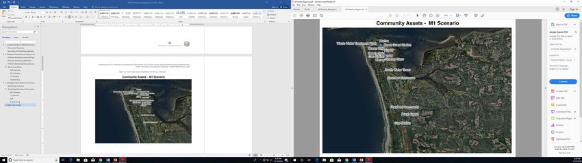
Figure 22. Community Assets Identified by Friday M1 Group - Westport................................................. 28
Figure 23. Community Assets Identified by Friday M1 Group - Regional .................................................. 29
Figure 24. Community Assets Identified by L1 Group - Regional .............................................................. 31
Figure 25. Community Workshop Room Setup ......................................................................................... 34
Figure 26. Base Map of Westport Prepared for the Workshop ................................................................. 35
ii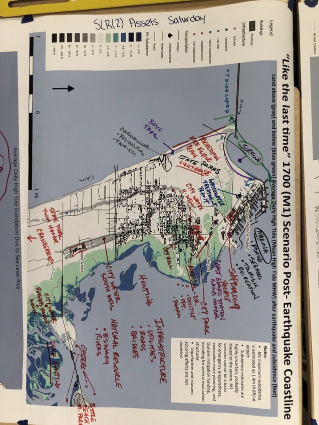
Localizing Hazard Mitigation: Recommendations for Westport’s Comprehensive Plan Update
                                                             Workshop Documentation Appendix | URBDP 508B Autumn 2018

Figure 27. Base Map of the Peninsula Prepared for the Workshop .......................................................... 36
Figure 28. Community Assets Identified by Saturday SLR Group 1 - Region ............................................. 38
Figure 29. Community Assets Identified by Saturday SLR Group 1 - Westport ......................................... 39
Figure 30. Community Assets Identified by Saturday SLR Group 2 – Region ............................................ 40
Figure 31. Community Assets Identified by Saturday SLR Group 2 - Westport ......................................... 41
Figure 32. Community Assets Identified by Saturday M1 Group – Westport ........................................... 44
Figure 33. Community Assets Identified by Saturday M1 Group – Region ................................................ 45
Figure 34. Community Assets Identified by Saturday L1 Group – Westport ............................................. 48
Figure 35. Community Assets Identified by Saturday L1 Group - Region .................................................. 49
Figure 36. Sea Level Rise for Westport and South Beach, WA, corrected March 2019, post-workshop... 53

iii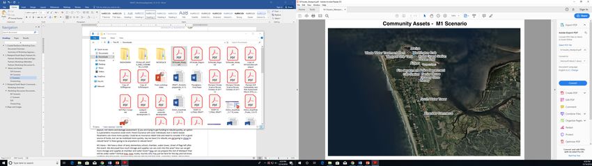
Localizing Hazard Mitigation: Recommendations for Westport’s Comprehensive Plan Update
                                                          Workshop Documentation Appendix | URBDP 508B Autumn 2018

1. Coastal Resilience Workshop Summary
1.1. Document Overview

This document includes a summary and documentation of two workshops held in Westport on Friday
and Saturday, November 16 -17, 2018. It constitutes an appendix to the University of Washington (UW)
Urban Design & Planning 508B Studio report of Recommendations for the City of Westport’s
Comprehensive Plan Update (Recommendations Report). UW faculty and students and members of the
Westport Steering Committee or the project (Steering Committee) co-designed the workshops to
engage partners and community members in hazard resiliency planning and gather input to inform the
recommendations made in the Recommendations Report. This Appendix includes a summary of the
workshop outcomes, as well as documentation from the discussions that took place both days. The
workshops served as the primary opportunity for the UW team to gather input from a diverse
representation of partners and community members, building on information gathered during previous
meetings, site visits, and interviews.

1.2. Summary of Workshop Approach and Outcomes

This section provides a brief summary of the approach used during the two workshops and overarching
themes that emerged from discussions. The two workshops consisted of (1) an invitation-only “Partners
Workshop” for local leaders in planning and emergency management on Friday, Nov. 16, and (2) a
“Community Workshop” widely advertised and open to the general public on Saturday, Nov. 17. More
detail on the approach and outcomes for each day is provided below. Both workshops focused on the
theme of making hazard mitigation more meaningful to the community and actionable in Westport and
the larger South Beach area. Workshop goals included:

      •   Build on the community’s already-significant accomplishments in preparing for a large
          earthquake and tsunami, including its construction of North America’s first tsunami vertical
          evacuation structure;
      •   Help the City update its Comprehensive Plan Update, to include hazard mitigation in a way that
          reflects Westport/South Beach values and needs;
      •   Raise public awareness of households’ needs and means to be prepared for emergencies, and
          encourage a culture of community self-reliance and mutual help;
      •   Discover everyday value in preparing for rare and uncertain future events, based on the use of
          complex and evolving scientific knowledge about multiple locally relevant hazards.

Though there were some minor differences between the two days, the workshops drew from the same
general approach and organization of activities and discussion sessions, outlined in Figure 1 below.

                                           Discuss scenarios of
                                                                                  Discuss
    Identify values and assets of the            change,
                                                                              opportunities for
        Westport/South Beach               vulnerabilities, and
                                                                              adaptation to the
               community                    opportunities for
                                                                               "new normal"
                                              strengthening

                                Figure 1. Overview of Workshop Approach and Structure

1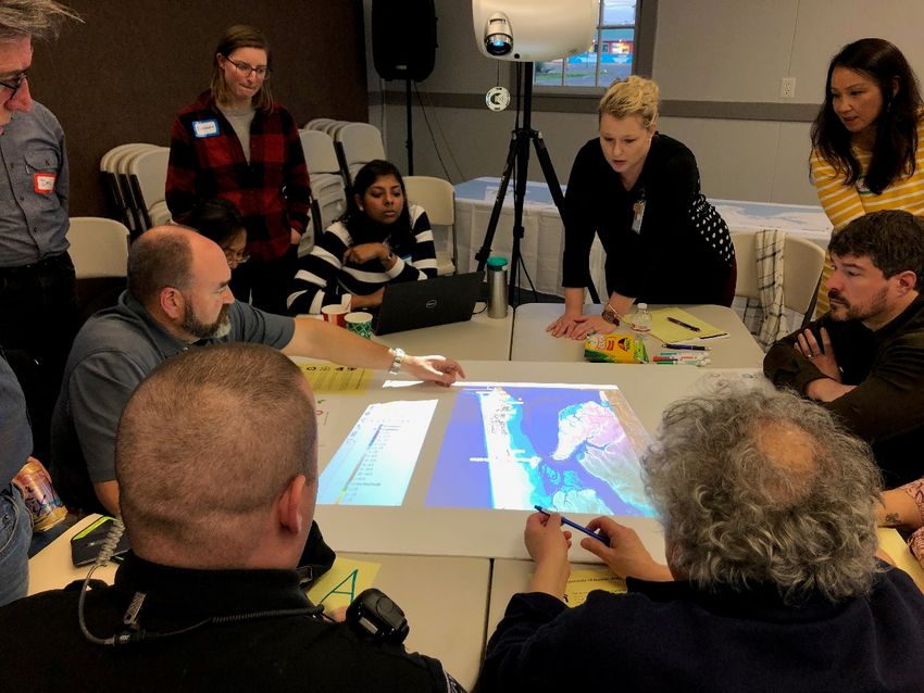
Localizing Hazard Mitigation: Recommendations for Westport’s Comprehensive Plan Update
                                                           Workshop Documentation Appendix | URBDP 508B Autumn 2018

1.2.1.Values and Assets
In both workshops, participants first considered Westport/South Beach community values and then
identified and located assets that support those values. This “appreciative inquiry” approach, rather
than beginning with a focus on hazards and vulnerabilities, encourages participants to think about
changes as opportunities rather than threats and helps them develop a holistic set of criteria to use in
identifying hazard mitigation strategies.1 Values were defined as: “what makes Westport/South Beach a
great place to live, work and play?” Participants were encouraged to think of values as more general
qualities, such as “I like how everyone knows each other” or “the fishing and hunting are really good
around here; I can earn a living doing these things and feed my family!” They might be even more basic
such as “good healthcare”. Assets, on the other hand, were intended to consist of specific places, groups
or activities that support these values and can be identified on a map or associated with particular
amenities, facilities, institutions, businesses, people or events.

While the identified assets and values varied among days and discussion groups, many participants
identified common themes. Table 1 below includes a summary of values and assets highlighted by
workshop participants.
Table 1. Westport/South Beach Community Values and Supporting Assets

    Values            Description and Supporting Assets
    People are        The people are hardworking, self-sufficient, innovative, resourceful and outdoor
    resilient         survivalists. The know how to fix boats, car, house, equipment, hunt, fish, and live
                      outdoors.
    Social bonds      People meet each other on the docks, at school events, at church gatherings or in
                      the neighborhood. They help each other out and people have strong sense of
                      belonging, community, and cultural identity here.
    Education         The Westport Timberland Library and Ocosta School District are valued for
                      providing education and communal space for children and families.
    Naturally         The ocean and forests surrounding Westport provide an abundant amount of fresh
    available foods   seafood, elk, deer, berries, and mushrooms for the community to fish, hunt, and
                      collect freely with the right permits and equipment.
    Natural           The scenic ocean views, local fisheries and aquaculture, and cranberry bogs are the
    resources for     heart of the economy in this area. Scenic ocean views drives tourism along the
    economic          beaches and in the marina district. The local fisheries provide jobs for fishermen,
    vitality          and the seafood is processed in plants in the marina district. The fisheries also
                      provide charter companies with tourists who want to do deep-ocean fishing. The
                      cool climate and farmlands provide a place for cranberry bogs and a robust
                      cranberry industry to thrive. Surrounded by the ocean, the city is an ideal place for
                      a boating development industry.
    Natural           State and local parks and beaches provide excellent recreational space for hiking,
    features for      running, walking, and site seeing. The ocean provides a place for swimming and
    recreation        surfing. These natural features enhance community health and well-being.

1
 An earlier version of the approach is discussed in Freitag, R. C., Abramson, D. B., Chalana, M., & Dixon, M. (2014). Whole
Community Resilience: An Asset-Based Approach to Enhancing Adaptive Capacity before a Disruption. Journal of the
American Planning Association, 80(4), 324-335.

2
Localizing Hazard Mitigation: Recommendations for Westport’s Comprehensive Plan Update
                                                          Workshop Documentation Appendix | URBDP 508B Autumn 2018

    Values            Description and Supporting Assets
    Rural, seaside,   The area’s rural character provides clean water and air which allow the natural
    and small-        features to thrive and enable people to enjoy the outdoors. The city feels quiet and
    town local        relatively safe, there is minimal traffic, and the area is not densely populated. The
    character         downtown area has mostly local, non-franchised businesses and maintains a
                      seaside character. People appreciate the quality of life here.
    Public services   Local and regional public agencies support and enhance community safety and
                      security.
    Affordability     Affordable housing and high-quality food in the area make it an attract place to live
    and               while enhancing quality of life. The natural resources (e.g., fishing, oyster, seafood
    employment        processing, cranberry farming) and downtown businesses provide employment
    opportunities     opportunities for residents of the region.
    Historical        The people of Westport are proud of their heritage and history. The Grays Harbor
    features          lighthouse and Westport Maritime Museum encapsulate these values.

Figure 2 shows community members and UW facilitators building a list of values and assets during the
Saturday, November 17, workshop.

                           Figure 2. Values and Assets Brainstorming and Mapping Discussion

1.2.2. Hazards Scenarios
Following discussions of values and assets, the UW team shared information about different potential
hazard scenarios that Westport/South Beach could face. The workshops focused on flooding and
coastline change associated with sea level rise (SLR), as well as tsunamis and land subsidence associated
with two possible scenarios of Cascadia Subduction Zone (CSZ) earthquake. In each workshop, one or

3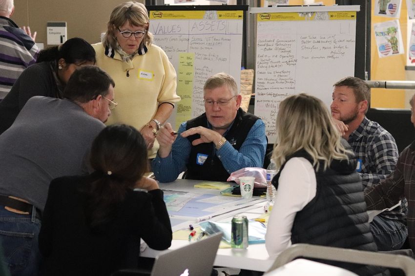
Localizing Hazard Mitigation: Recommendations for Westport’s Comprehensive Plan Update
                                                               Workshop Documentation Appendix | URBDP 508B Autumn 2018

two table groups discussed the same set of SLR information, while two other table groups each
discussed a different earthquake and tsunami scenario.2

The SLR information included projections for 2060, 2080, and 2100. Table 2 shows the SLR projections
with different probabilities of coastal flooding for each time horizon.
Table 2. SLR Predictions and Associated Probabilities

    Amount of SLR                  2060                             2080                              2100
    1 foot                         11% probability                  51% probability                   77% probability
    2 feet                          0% probability                   5% probability                   27% probability
    3 feet                          0% probability                   1% probability                    5% probability
Source: table generated on 07/18/18 for the Washington Coastal Resilience Project, www.coastalnetwork.com/wcrp-documents.html

Both workshops also explored two near-source tsunami scenarios: one generated by a “medium” and
“most shallow” Magnitude 8.9, or “M1”, Cascadia subduction zone (CSZ) earthquake, which most
resembles the last time a CSZ earthquake and tsunami occurred in 1700; and another generated by a
“large” and “most shallow” Magnitude 9.0, or “L1”, CSZ earthquake. Figure 3 shows how the M1 and L1
earthquake scenarios compare to other possible CSZ earthquake sources of tsunamis, in terms of: their
magnitude (Mw); their depth below the ocean floor (most shallow, shallow, or deep); their likelihood of
occurrence (i.e. if a CSZ earthquake occurs at all, what is the chance it will take one or another of these
forms); and their associated amount (in meters) of uplift (red) or subsidence (blue) of the ocean bottom
and land. Note that uplift and subsidence varies considerably at different distances from the fault
offshore towards the land. (Contour intervals for uplift/subsidence are 3 meters, with reference to the
tide level at Mean High Water.) These details of earthquake behavior are all very difficult to predict, not
to mention the position along the 620-mile-long CSZ at which the next rupture might occur, and because
they determine tsunami behavior at any one point on the coast, it is also difficult to predict that
behavior, including the tsunami’s time of arrival on the coast after the earthquake happens, the number
and duration of waves, the depth and extent of flooding, the direction and speed of currents, etc.

Definitions and Acronyms

SLR = Sea level rise

MHW = Mean high water

CSZ = Cascadia Subduction Zone

L1 = Large and shallow magnitude 9.0 CSZ earthquake

M1 = Medium and shallow magnitude 8.9 CSZ earthquake

2
 Initially it was intended to have table groups rotate, “World Café”-style, at the end of the workshop so that most
participants would have a chance to discuss more than one scenario, but there was not enough time in the
schedule to allow that. However, each table reported out to the room, and this appendix and the Comprehensive
Plan Update recommendations themselves represent a synthesis of the workshop discussions.

4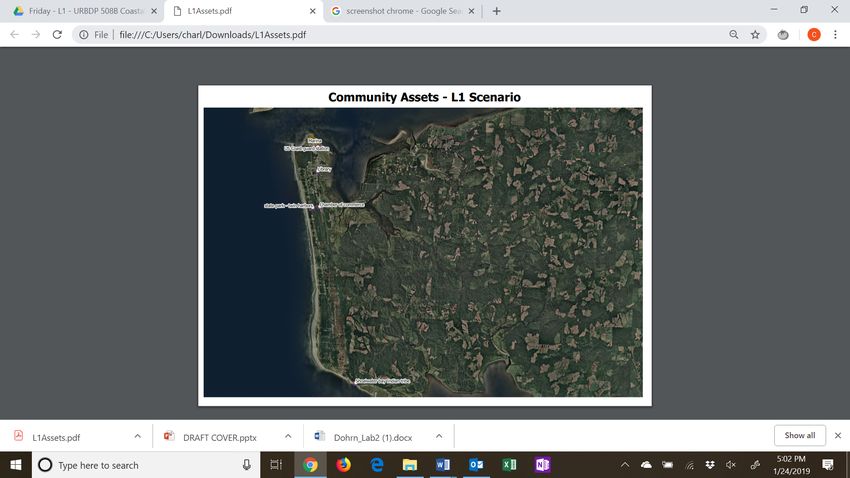
Localizing Hazard Mitigation: Recommendations for Westport’s Comprehensive Plan Update
                                                             Workshop Documentation Appendix | URBDP 508B Autumn 2018

Figure 3. Suite of 15 Possible Cascadia Subduction Zone Fault Earthquakes. Source: Frank Gonzalez, based on a hazard
assessment study for Bandon, Oregon. See Witter, Robert C, Yinglong Zhang, Kelin Wang, George R Priest, Chris Goldfinger,
Laura L Stimely, John T English, and Paul A Ferro (2011): Simulating Tsunami Inundation at Bandon, Coos County, Oregon, Using
Hypothetical Cascadia and Alaska Earthquake Scenarios. DOGAMI Special Paper 43 (July 11): 1–63.

5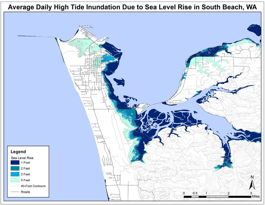
Localizing Hazard Mitigation: Recommendations for Westport’s Comprehensive Plan Update
                                                           Workshop Documentation Appendix | URBDP 508B Autumn 2018

Presentation of these scenarios in the workshops emphasized that both earthquake and climate impacts
modeling is probabilistic and uncertain, but it is based on an increasing amount of available historic data
and sophistication of methods to analyze it. Not all possible CSZ earthquake scenarios were considered,
nor were any distant-source earthquake-tsunami scenarios (such as the very large Alaska 1964 event).
Still, working simultaneously with SLR and two near-source earthquake-tsunami scenarios enabled the
participants to address both on-going, cumulative, and relatively more predictable if less severe changes
(SLR) as well rarer, sudden, and less predictable but possibly more severe changes (earthquakes and
tsunamis). Considering multiple scenarios has several benefits for the planning process, including:

    •    Helping to account for the uncertainty of future outcomes
    •    Encouraging forward-looking thinking beyond disaster response and survival, to mitigation,
         recovery and betterment
    •    Creating robust long-term strategies for land use and development, infrastructure and service
         investments, and environmental protection – i.e. strategies that work under multiple possible
         future scenarios of change
    •    Informing future decisions about prioritizing and implementing strategies

To inform discussion, the UW team developed several maps depicting flooding hazards and coastline
change associated with the scenarios for both the Partners Workshop and the Community Workshop.3
For each map, the UW team developed a version showing the full peninsula, and a version showing
Westport. There was one SLR map depicting the 1-, 2- and 3-foot rise in sea level shown in Table 2
(Figures 4 and 5; same map showing Westport and the peninsula).4

Maps showing earthquake and tsunami hazards referred to both the “T-shirt sizes” of M1 and L1
earthquake scenarios depicted in Figure 3, but also referred to them in less specialized language,
respectively: M1 = “Like the last time”, i.e. what occurred in 1700; and L1 = “Maximum Considered” for
official State emergency planning purposes.

For each of these earthquake scenarios, the UW team prepared two types of maps: one type showing
the inundation areas and maximum flooding depths over land during the first four hours following an
M1 earthquake (Figures 6 and 7) and an L1 earthquake (Figures 8 and 9); and one type showing loss of
coastal land due to earthquake subsidence following M1 (Figures 10 and 11) and L1 events (Figures 12
and 13). The flooding depth maps were used only in the Partners Workshop, which addressed both
immediate tsunami response as well as long-term mitigation, recovery, and adaptation to possible “new
normal. The Community Workshop used only the subsidence maps as it focused primarily on
anticipating these “new normals”.

3
  The maps were based on fine resolution Digital Elevation Models (DEMs) developed by the National Oceanic and
Atmospheric Administration (NOAA) specifically for tsunami modeling on the Washington coast, and calculate
elevations from Mean High Water (MHW). Available at https://catalog.data.gov/dataset/astoria-oregon-1-3-arc-
second-mhw-coastal-digital-elevation-model
4
  Note that the SLR maps shown in the workshop contained an error, by depicting what is actually a 5-foot rise in
sea level as a 3-foot rise. See the Erratum at the end of this Appendix that shows the correct areas flooded at 1-, 2-
, 3- and 5-foot rise in sea level (Figure 36). Given that the two time-horizons for which workshop participants chose
to discuss SLR effects – 2060 and 2080 – involved only 0% and 1% probabilities of 3-foot sea level rise respectively,
the impact of this error on discussion was probably negligible.

6
Localizing Hazard Mitigation: Recommendations for Westport’s Comprehensive Plan Update
Workshop Documentation Appendix | URBDP 508B Autumn 2018
Figure 4. Regional Map of Average Daily High Tide Inundation under Different SLR Scenarios (1-3 feet)
7Localizing Hazard Mitigation: Recommendations for Westport’s Comprehensive Plan Update
Workshop Documentation Appendix | URBDP 508B Autumn 2018
Figure 5. Westport Map of Average Daily High Tide Inundation under Different SLR Scenarios (1-3 feet)
)
8Localizing Hazard Mitigation: Recommendations for Westport’s Comprehensive Plan Update
Workshop Documentation Appendix | URBDP 508B Autumn 2018
Figure 6. Regional Map Depicting Land Subsidence after an M1 Event
9Localizing Hazard Mitigation: Recommendations for Westport’s Comprehensive Plan Update
Workshop Documentation Appendix | URBDP 508B Autumn 2018
Figure 7. Westport Map Depicting Land Subsidence After an M1 Event
10Localizing Hazard Mitigation: Recommendations for Westport’s Comprehensive Plan Update
Workshop Documentation Appendix | URBDP 508B Autumn 2018
Figure 8. Regional Map Depicting Land Subsidence After an L1 Event
11Localizing Hazard Mitigation: Recommendations for Westport’s Comprehensive Plan Update
Workshop Documentation Appendix | URBDP 508B Autumn 2018
Figure 9. Westport Map Depicting Land Subsidence After an L1 Event
12Localizing Hazard Mitigation: Recommendations for Westport’s Comprehensive Plan Update
Workshop Documentation Appendix | URBDP 508B Autumn 2018
Figure 10. Regional Map Depicting Max Flooding Depth of M1 Event
13Localizing Hazard Mitigation: Recommendations for Westport’s Comprehensive Plan Update
Workshop Documentation Appendix | URBDP 508B Autumn 2018
Figure 11. Westport Map Depicting Max Flooding Depth of an M1 Event
14Localizing Hazard Mitigation: Recommendations for Westport’s Comprehensive Plan Update
Workshop Documentation Appendix | URBDP 508B Autumn 2018
Figure 12. Regional Map Depicting Max Flooding Depth of an L1 Event
15Localizing Hazard Mitigation: Recommendations for Westport’s Comprehensive Plan Update
Workshop Documentation Appendix | URBDP 508B Autumn 2018
Figure 13. Westport Map Depicting Max Flooding Depth of an L1 Event
16Localizing Hazard Mitigation: Recommendations for Westport’s Comprehensive Plan Update
Workshop Documentation Appendix | URBDP 508B Autumn 2018
To further prompt participants to think positively and creatively for the long term, the UW team also
first presented some imagery of historic coastline change on the Westport peninsula, due to sediment
deposit and erosion, dredging and filling, and construction of the Westhaven jetty (Figures 14-16), and
asked participants to recall any memories they had of previous earthquakes and tsunamis. Participants
were encouraged to consider how much change the community had already experienced over 150
years, how it had responded to that change as well as created much of it itself, and therefore how future
changes could pro-actively achieve co-benefits of mitigation, as opposed to being just reactive to
conditions outside of the community’s control.
Figure 14. Imagery of Historic Coastline: 1860 Map of the Westport Peninsula and Grays Harbor. Map Source: NOAA Non-
georeferenced NOAA Shoreline Survey Scans, https://nosimagery.noaa.gov/images/shoreline_surveys/survey_scans/T-821.jpg
17Localizing Hazard Mitigation: Recommendations for Westport’s Comprehensive Plan Update
Workshop Documentation Appendix | URBDP 508B Autumn 2018
Figure 15. Imagery of Historic Coastline: 1910 Map of the Westport Peninsula and Grays Harbor. Map Source: NOAA Non-
georeferenced NOAA Shoreline Survey Scans, https://nosimagery.noaa.gov/images/shoreline_surveys/survey_scans/T-3044.jpg
18Localizing Hazard Mitigation: Recommendations for Westport’s Comprehensive Plan Update
Workshop Documentation Appendix | URBDP 508B Autumn 2018
Figure 16. Imagery of Historic Coastline: 1950 Map of the Westport Peninsula and Grays Harbor. Map source: : NOAA Non-
georeferenced NOAA Shoreline Survey Scans
Some examples of common themes that emerged from discussions are described below; see Sections 2
and 3 for more detail on discussions.
• Transportation Infrastructure Improvements: Participants frequently discussed their perception
that Westport’s key transportation infrastructure (e.g., highways, roads, bridges) may be
vulnerable to hazards, there is a risk of “being cut off” in an event, and resilience needs to
include infrastructure improvements, both for mobility and communication. Such improvements
could bring the co-benefits of participation in rural broadband development and attraction of
employment opportunities.
• Increasing Preparedness: Participants discussed the need to make sure other residents are
aware of hazards and that all residents have a plan in place to respond to an event. They
discussed increasing preparedness through outreach, as well as practical approaches like
gathering supplies and establishing more evacuation/meeting sites where residents can go
during/after an event. Co-benefits to such preparedness would be increased sociability among
residents and greater “situational awareness” at an individual level.
• Uncertain Response to Large/Rare Events: Participants had difficulty envisioning adaptation to
the “new normal” following a large (M1 or L1) type event, and what the city could do now to be
resilience to the possibility of such an event. Some of the ideas in response to SLR, such as
improvements to key bridges and highways leading to the peninsula, or restrictions on building
in flood-prone areas, were noted as being useful also for mitigating impacts of an earthquake,
tsunami, and land loss due to subsidence. A significant area of possible action included exploring
19Localizing Hazard Mitigation: Recommendations for Westport’s Comprehensive Plan Update
Workshop Documentation Appendix | URBDP 508B Autumn 2018
the relocation of critical facilities and services facilities out of harm’s way, to higher ground
within the peninsula, and even outside Westport’s city limits, which might bring opportunities
for new investment and improved facilities. However, participants worried whether “Westport
would still be Westport” if large parts of the community had to abandon the peninsula, either in
anticipation of a major disaster, or in recovery from one.
2. Westport/South Beach Partners Coastal Resilience Workshop
Documentation
This section documents the Friday, November 16, 2018 Partners Workshop, including an overview of the
workshop and documentation of discussion sessions.
2.1. Partners Workshop Goal and Agenda
The Partners Workshop focused on the theme of making hazard mitigation more meaningful to the
community and actionable in Westport. Overall workshop goals are described in the summary section
above. The Partners workshop, however, as a gathering of local leaders and other experts in hazards
mitigation and emergency planning, including members of the Westport/South Beach Tsunami Safety
Committee who are currently leading the community’s efforts to build more tsunami vertical evacuation
structures, addressed information about tsunami inundation and flood depths that was not used in the
Community Workshop.
The Partners Workshop included a combination of presentations, facilitated discussion/brainstorming
exercises, and participatory mapping. Mapping exercises during the Partners Workshop were conducted
using WeTable, a participatory geographic information system (GIS) platform that uses open-source
QGIS software and a projector, allowing participants to digitize geographic information in real time using
a calibrated pen and a tabletop map projection (Figure 17 17).
20Localizing Hazard Mitigation: Recommendations for Westport’s Comprehensive Plan Update
Workshop Documentation Appendix | URBDP 508B Autumn 2018
Figure 17. Participants in the Partners Workshop use WeTable to Map Values and Assets
Participants sat at tables set up to discuss one of the three hazard scenarios (SLR, M1, L1, see Figure 18
18). The room was set up to allow some experts and observers to “float” but in fact nearly all
participants joined one or another of the tables.
21Localizing Hazard Mitigation: Recommendations for Westport’s Comprehensive Plan Update
Workshop Documentation Appendix | URBDP 508B Autumn 2018
Local facilitator-
PARTICIPANTS Board Scribe storyteller
COFFEE AND REFRESHMENTS
1. WESTPORT/ Floating expert
COUNTY/ Modeler/scientist
consultants and
observers
POST-IT BOARD
STATE
weTable
Tripod-projector
M1
2. UW
KITCHEN
WeTable operator
Notetaker
POST-IT BOARD Board Scribe
Local facilitator-
storyteller
Board Scribe
POST-IT BOARD
Tripod- SLR
weTable
projector weTable
L1
WeTable Modeler/scientist
operator Local facilitator- Notetaker
storyteller WeTable operator
ENTRANCE
Notetaker Modeler/scientist
Tripod-projector
SIG
N
IN
SCREEN
Overall facilitator Floating facilitator Floating weTable troubleshooter
Figure 18. Partners Workshop Room Setup
Table 3 below includes the workshop agenda and approximate timing of the meeting. Sub-sections in
this appendix are organized by scenario and roughly follow the agenda below.
Table 3. Partners Workshop Agenda
Approximate Timing Agenda Item
2:30-3:00pm Coffee and refreshments
3:00-3:10pm Welcome and introductions
3:10-3:15pm Overview of workshop goals and activities
3:15-3:45pm Discussion Round 1: Values and asset mapping
3:45-4:25pm Discussion Round 2: Scenarios of change and survival
4:25-4:45pm Discussion Round 3: Strategies of adaptation to possible “new normals”
4:45-4:55pm Report out: Storytelling
4:55-5:00pm Next steps
2.2. Partners Workshop Participants
The Partners Workshop convened 24 individuals representing the city, county, and state agencies with
expert knowledge regarding Westport and/or hazard mitigation planning in the region, as well as UW
team members. Participants included representatives of the following organizations listed in Table 4
below.
Table 4. Participating Organizations
Organization Type Represented Organizations
City of Westport/South Beach area Department of Public Works, Police, Chamber of Commerce,
South Beach Regional Fire Authority, Ocosta School, Tsunami
22Localizing Hazard Mitigation: Recommendations for Westport’s Comprehensive Plan Update
Workshop Documentation Appendix | URBDP 508B Autumn 2018
Organization Type Represented Organizations
Safety Committee, Westport Property Development,
Timberland Library, Westport-by-the-Sea condominiums
County Agencies Grays Harbor County Department of Emergency Management,
State Agencies Washington State Parks, Washington State Emergency
Management Division
Other local stakeholders Shoalwater Bay Tribe
UW Faculty and Students Department of Urban Design & Planning, Dept. of Applied
Mathematics, Dept. of Civil & Environmental Engineering,
Dept. of Earth & Space Sciences, School of Forestry and
Environmental Sciences, Pacific Northwest Seismic Network,
US Geological Survey
2.3. Partners Workshop Discussion Documentation
As described in the Summary of Workshop Approaches and Outcomes section above, meeting
participants first discussed values of Westport/South Beach. UW Facilitators prompted this discussion
with the question: “What makes Westport/South Beach a great place to live, work and play?” In
addition, facilitators provided lists universal quality-of-life values excerpted from the United Nations
Millenium Ecosystem Assessment (e.g., shelter, food, etc.). Following the value-brainstorming exercise,
facilitators asked participants to list community- and place-specific assets that support each value. Note-
takers recorded the list of values and assets
on poster paper. Figure 19 shows an example
of the values-assets brainstorm. In addition to
listing assets, participants marked the location
of each asset on a projected map of the
Westport peninsula; the geographic location
of each asset was recorded using WeTable
and saved to a map for each scenario group.
The SLR, M1, and L1 subsections below
include information from the values
discussion and asset mapping exercise for
each scenario.
After discussing values and assets, the UW
team presented stories of coastal change,
illustrating potential changes that Westport
could face by presenting historical shoreline
maps (Figures 14-16), maps of flooding depth
and subsidence in an M1 earthquake and
tsunami scenario, and maps of flooding depth
and subsidence in an L1 earthquake and
tsunami scenario. The UW team also
presented information about earthquake
Figure 19. Example Values and Assets Brainstorm
23Localizing Hazard Mitigation: Recommendations for Westport’s Comprehensive Plan Update
Workshop Documentation Appendix | URBDP 508B Autumn 2018
modeling uncertainty, liquefaction, and tsunami inundation areas and evacuation.
In addition to information on each scenario, the UW team asked respondents for memories of the 1964
Alaska Earthquake and tsunami. Participants recalled hearing news reports of the event, being afraid of
a tsunami, and the evacuation process. They described how the whole Westport peninsula was
evacuated to high ground where the school is now.
Following the presentation of the hazard scenarios, facilitators asked participants to identify assets that
would be lost in an event and think about existing assets that could support community values in the
place of lost assets. Finally, facilitators asked participants to imagine how the community could adapt to,
prepare for, or take advantage of the “new normal” suggested by their scenarios, including
brainstorming strategies that would help Westport/South Beach continue to support its values. The SLR,
M1, and L1 subsections below also include information from these discussions.
2.3.1. Sea Level Rise (SLR) Scenario
The SLR discussion group identified and discussed the following values and assets included in Table 5.
Figures 20 and 21 below show the assets that the SLR group mapped.
Table 5. Partners Workshop SLR Group Discussion of Values and Assets
Values Assets
Outdoor recreational opportunities Parks and beaches; ocean; Westport lighthouse; state parks,
including the Grayland beach state park
Independence None indicated
Education School
Close-knit community School
Strong family and friends ties School
Vision and innovation School
Access to fresh seafood Ocean; Brady’s Oysters, Westport Marina
Quality of life Downtown, marina area, cranberry bogs
Natural beauty and history lighthouse
Low crime rate None indicated
Scientific opportunities local clues to regional earthquakes/tsunamis (on the harbor/
shores/ intertidal zones); John's River
Tourism None indicated
Health None indicated
Good social relations None indicated
Security None indicated
Freedom of choice None indicated
Other Airport, highways, marina, police, fire department, homes
24Localizing Hazard Mitigation: Recommendations for Westport’s Comprehensive Plan Update
Workshop Documentation Appendix | URBDP 508B Autumn 2018
Figure 20. Community Assets Identified by Friday SLR Group - Westport
25Localizing Hazard Mitigation: Recommendations for Westport’s Comprehensive Plan Update
Workshop Documentation Appendix | URBDP 508B Autumn 2018
Figure 21. Community Assets Identified by Friday SLR Group - Regional
In addition to the values and assets listed above, the group discussed the following:
• Westport is an attractive destination for tourists; a lot of tourists visit the area and the outdoor
recreation opportunities are a draw
• The area is rich in natural beauty and people statewide benefit from scientific evidence of past
hazard events found in the Westport area
• Westport is a safe place without gangs or violence
• Downtown Westport is a business hub, most businesses are located there
• The cranberry bogs and related industry support values and family ties
After discussing values and assets and hearing the presentation about potential hazards, the group
discussed vulnerabilities. Discussion focused on the themes listed below.
• Transportation and public service infrastructure: Participants identified the airport, highways
(including to Aberdeen), police, and fire department as vulnerable to SLR. Participants discussed
that access to the town will be compromised, including the highway to the south east, noting
that even a bad El Nino year could cut off road access. They also noted that the airport and
associated assets will be lost to SLR. The clinic is not vulnerable to SLR.
• Marina/commercial district and businesses: Participants observed that with 1 foot of SLR, the
marina is not affected, but parts of the commercial district are. They noted that Brady's has high
ground next to it.
26Localizing Hazard Mitigation: Recommendations for Westport’s Comprehensive Plan Update
Workshop Documentation Appendix | URBDP 508B Autumn 2018
• Residential areas: Homes may be lost to SLR, but possibly not at only one foot of rise.
• Other topics: Participants expressed concern over replacing lost assets.
For the discussion of “new normal” and strategies to help support Westport’s values, participants
focused on the 2060 SLR scenario (1 foot; 11% probability). Discussion included the themes listed below.
• Relocation: Possible to buy out properties and move homes, though Taholah has been working on
that for 20 years without much progress; need to move the airport
• Infrastructure investments: Need to address risk to the marina through a possible retrofit; can
make periodic infrastructure investments with federal support; concern about safety of the bridge
and need to plan a new bridge; bridge is outdated so there may be the possibility to gain political
support for replacement; road could be rerouted through Ocosta; need for climate resilient building
codes; need to reroute and elevate roads, including a possible levy system.
• Political context: Potential lack of political will to build something for 40 years from now; SLR in
Westport may not be a top priority. City government is a strong asset for advocating for a new bridge
or better road, because some decision-makers still deny SLR.
• Other topics: Assets overlap between sea level rise and subsidence, so strategies are relevant to
both scenarios; Brady’s oysters may be affected by SLR, but oyster beds could move further in.
School will remain.
2.3.2. M1 “Like the Last Time (1700)” Earthquake and Tsunami Scenario
The M1 discussion group identified and discussed the following values and assets included in Table 6.
Figures 22 and 23 below include the assets mapped by the M1 group.
Table 6. Partners Workshop M1 Group Discussion of Values and Assets
Values Assets
Fishing industry; including a strong sense of Ocean companies, including WA crab, ocean cold,
belonging to the fishing industry Ocean Gold, Harn’s, the docks and marina, the
Tokeland marina, oyster processing facilities, the
Westport shipyard, and the fishing fleet
Tourism industry, in the context of the Chamber of Commerce, small businesses
tourism value being rooted in Westport being
a unique place that people want to visit
Education and school system are valued in Ocosta School, library, high school
this area, including successful athletic
programs
Culture of community support and strong The community group called We Fish (a group of
sense of community; one participant noted: families that have helped to build community);
“Being not from the area, it’s clear how much Maritime museum, Marina, and port office; churches
coastal communities have a strong sense of though they are sometimes not well attended; Stores
community. People stick together, fall and and restaurants including the grocery store, the
rise together, have strong bonds between Hungry Whale and the Midtown Deli; community
neighbors.” centers including the Westport Y, VFW and the Senior
Center, the Grange Hall, the Rec Hall, and the
Grayland Community Center; attractions like the
observation tower
27Localizing Hazard Mitigation: Recommendations for Westport’s Comprehensive Plan Update
Workshop Documentation Appendix | URBDP 508B Autumn 2018
Values Assets
Access to parks, beaches, and nature State Parks including Westhaven, Twin Harbor, Bottle
Beach, Westport Light, and Grayland Beach; the Long
Beach peninsula
Cranberry industry None indicated
Self-reliance of residents Access to hunting and fishing
Necessary material Water infrastructure, including the north water tower
and wastewater treatment plant, the south water
tower; gas stations and stores; airports and rural
runways
Health One in-town doctor’s office called the Beach Clinic
that houses one doctor, one PA, one nurse
practitioner; the main hospital is 30 minutes away in
Aberdeen
Social relations City Hall
Security Fire department, some stations down south in
Grayland; coast guard station; police department
Figure 22. Community Assets Identified by Friday M1 Group - Westport
28Localizing Hazard Mitigation: Recommendations for Westport’s Comprehensive Plan Update
Workshop Documentation Appendix | URBDP 508B Autumn 2018
Figure 23. Community Assets Identified by Friday M1 Group - Regional
The M1 group discussed assets that are vulnerable to an M1 tsunami scenario, including:
• Assets that support the fishing industry, including seafood processing plants, docks and the
marina, and the shipyard, boats
• The library could be affected, and the high school would be unlikely to survive; the old part of
the elementary school would also be affected
• Assets that support Westport’s sense of community would be affected, including the maritime
museum and marina area, as well as grocery stores, restaurants, and community centers
• Assets that provide necessary resources, including gas, transportation infrastructure (e.g., roads
and bridges), and water infrastructure (e.g., wastewater treatment)
• Routes to the vertical evacuation structure
The M1 group also discussed adapting existing assets, including:
• Chamber of commerce can be used to store and provide supplies
• Tsunami vertical evacuation structure at Ocosta School is a key asset for hazard response and is
stocked with food, water, and some emergency supplies, but may need more.
• Preparing residents to have their own evacuation kits
• Using the water tower as another location for supplies
• Identify areas on high ground where the city can store supplies
• Areas that can provide opportunities to evacuate by air
29Localizing Hazard Mitigation: Recommendations for Westport’s Comprehensive Plan Update
Workshop Documentation Appendix | URBDP 508B Autumn 2018
Discussion of adaptation to a “new normal” focused on the following:
• Preparing and recovering from hazards: need to develop evacuation routes, provide more
vertical evacuation in accessible places, and gather more supplies (e.g., food, water, radios, and
generators) to store in evacuation areas; need to work with state and county to ensure there is
a plan for Westport in the event of a disaster
• Improving transportation and infrastructure: bridges may be destroyed by earthquakes; will
need to re-establish the jetty after the event; need to identify logging roads that could be used
for accessing Westport after an event; need to mitigate risks of tree fall and landslides on access
roads; need more signage demarcating tsunami zones and evacuation routes
• Education: need to educate residents about risks; need to educate tourists who visit Marina
district in the summer, other areas have brochures and outreach to hotels; need to make
presentations to hotel and motel owners and do outreach to campers in the state park (county
is working on these projects currently); need to provide information about how to respond to an
earthquake and tsunami
• Funding: Need to identify sources of funding (e.g., FEMA) to help with preparedness
• Multi-use evacuation structures: could create vertical evacuation structures to be a tourist
attraction, providing vertical evacuation and education; could also incorporate event center and
multi-purpose area
2.3.3. L1 “Maximum Considered” Earthquake and Tsunami Scenario
The L1 discussion group identified and discussed the following values and assets included in Table 7.
Figure 24 below show the assets mapped by the L1 group.
Table 7. Partners Workshop L1 Discussion Group of Values and Assets
Values Assets
Going fishing (as a chance beaches, ships, docks, jetty
to meet people) and
crabbing
Having a sense of Residential areas and neighbors, State Parks and beaches, fishery,
community and strong boats, marina; one participant noted: “A lot of people know each other
social bonds and when people do need help, everybody helps.”
Obtaining benefits from Fishery, oyster farms, beach, tourism industry, ship/boats industries,
the local resources (natural marina, businesses, restaurants, ship yards, fish processing; one
and economic) participant noted: “We do have everything here in Westport”
Having unique waterfront Beaches, ships, fishery, marina and dock area, tourism (infrastructure),
businesses and rural safe neighborhoods,
character
Having unique culture and Library is cultural, social, and educational asset; the school, along with
strong cultural identity its evacuation center is an important part of the community; include
Tokeland and Shoalwater Bay Tribe as parts of the community; the 105
bridge; neighbors and community; marina and jetty; beaches and
nature
Obtaining support from Fire department; Chamber of Commerce because it provides us with
public service providers natural, cultural, business/economic resources and policy; Police
station for public safety; drugs store/pharmacy and clinic
30Localizing Hazard Mitigation: Recommendations for Westport’s Comprehensive Plan Update
Workshop Documentation Appendix | URBDP 508B Autumn 2018
Figure 24. Community Assets Identified by L1 Group - Regional
Following presentation of the hazard scenarios, L1 group members discussed values and assets that are
vulnerable to the L1 tsunami, including the themes described below.
• Sense of community and social bonds: residential areas will be affected, need to think about
the structures that will exist after event
• Cultural identity: need to add life safety information to important cultural centers
• Other values and assets: key public services like the police department will be gone, school will
be inundated; economy is strong but L1 will destroy many assets
The L1 group also discussed adapting existing assets, including:
• Planning for the worst, including that dunes and boats may not offer protection
• Strengthening access, including the need for access to relocate/move from the city and
considering how and where to relocate if infrastructure is destroyed – could require “starting
over”
• Need to ensure that people have insurance to help with rebuilding
31Localizing Hazard Mitigation: Recommendations for Westport’s Comprehensive Plan Update
Workshop Documentation Appendix | URBDP 508B Autumn 2018
Finally, the L1 group discussed proactive strategies for adapting to a potential “new normal” post
tsunami event, including the following themes.
• Buying new land: Participants noted that there might be a need to buy new land. Concerns
included funding to purchase land after a devastating disaster, zoning considerations, potential
lack of support from relying on the government, adjacent areas also being vulnerable, and
possible FEMA funding
• Moving infrastructure: Participants brought up the possibility of moving the city’s infrastructure
to Tokeland, nothing that the Marina will be destroyed.
• Relocating/moving to safer areas: Participants noted needs for access to the south, need for a
new bridge if destroyed, and need to somehow create cohesion if people need to be relocated;
concern that without economy and resources, people will leave and not return; need for access
to Aberdeen through timber lands.
• Regaining the collective memory of recovery experiences: need to draw from memory of
rebuilding and survival after tsunami in 1964 for long-term planning and education
2.3.4. Workshop Summary: Telling the Story of Westport/South Beach
After the final group discussions of strategies for adapting to a “new normal,” representatives from each
group shared from their group discussions, using a storytelling format. This section includes the “stories”
from each discussion group.
L1: “When we first started this project, I was very negative about L1, because what is left? But we’ve had
good discussion about what can you do. Regarding long-term planning over the next 40-50 years, do you
buy land and redevelop inland? This could be a good strategy. We will have a bit of land where we sit
here, but the infrastructure will be gone. When we looked at values – sense of community, economy,
shipbuilding, fishing, tourism, how community comes together and helps, rural character of Westport –
why people chose to live here, because it’s awesome to live here. In L1, everything goes away. How do
we plan to keep these things in place? We talked about many things, but focused on how to make it over
the bridge. The wastewater treatment and water tower are gone… do I go to city and ask for them to
build a new one that won’t be affected by L1? Can the city look for property outside the area and
encourage people to move? But if we move out there then we lose these values that are tied to where
Westport is and what it is. Long-term planning for L1 Cascadia scenario is very difficult. For example, if
you don’t have a school, people will not stay here… are we going to start building another school as a
long-term strategy? Will be hard to convince community to do this, but would be a good idea because it
will sustain our values. Do we move all the good stuff out of Westport? I don’t know. Do we annex land
for 15 miles? This is only the L1, there are bigger things that can happen. We encourage everyone to get
flood insurance.”
Comment: “There’s another insurance product – parametric insurance, where the event itself triggers
payout, not claims and damage assessment. If you are trying to get funding to rebuild quickly,
parametric insurance is an option that could work. Flood insurance will cover individuals; but it is claims
based. Parametric insurance can move more quickly. But it could be an insurance rabbit hole and you
would need to consider if it’s a good source of funds, but it can be mobilized more quickly. Say we have
money to rebuild, are people going to choose to rebuild here? Is there going to be anywhere to rebuild
here?”
M1: “We have a sliver of land, the elementary school, chamber, water tower, street of flags left after this
event. We discussed how much storage and supplies we can cram into this area. How can we get more
32You can also read