Migratory birds monitoring of India's largest shallow saline Ramsar site with big geospatial data using Google Earth Engine for restoration
←
→
Page content transcription
If your browser does not render page correctly, please read the page content below
Preprints (www.preprints.org) | NOT PEER-REVIEWED | Posted: 13 October 2021                                 doi:10.20944/preprints202110.0202.v1

          Type of the Paper (Article, Review, Communication, etc.)

          Migratory birds monitoring of India’s largest shallow saline
          Ramsar site with big geospatial data using Google Earth Engine
          for restoration
          Rajashree Naik and L.K. Sharma*

                                         Department of Environmental Science, School of Earth Sciences, Central University of Rajasthan, Bandarsindri,
                                           Ajmer, Rajasthan, India, Pin code: 305801; rajashree.bini06@gmail.com
                                         * Correspondence: laxmikant_evs@curaj.ac.in

                                         Abstract: Globally, saline lakes occupying 23% by area 44% by volume among all the lakes might
                                         desiccate by 2025 due to agricultural diversion, illegal encroachment, pollution, and invasive spe-
                                         cies. India’s largest saline lake, Sambhar is currently shrinking at the rate of 4.23% due to illegal
                                         saltpan encroachment. This research article aims to identify the trend of migratory birds and
                                         monthly wetland status. Birds survey was conducted for 2019, 2020 and 2021 and combined with
                                         literature data of 1994, 2003, and 2013 for visiting trend, feeding habit, migratory and resident ratio,
                                         and ecological diversity index analysis. Normalized Difference Water Index was scripted in Google
                                         Earth Engine. Results state that it has been suitable for 97 species. Highest NDWI values for the was
                                         whole study period was 0.71 in 2021 and lowest 0.008 in 2019 which is highly fluctuating. The de-
                                         creasing trend of migratory birds coupled with decreasing water level indicates the dubious status
                                         for its existence. If the causal factors are not checked, it might completely desiccate by 2059 as per
                                         its future prediction. Certain steps are suggested that might help conservation. Least, the cost of
                                         restoration might exceed the revenue generation.

                                         Keywords: Inland saline wetland; lake; ecosystem, biodiversity, human interventions, Google Earth
                                         Engine, Normalized Difference Water Index, Restoration

                                         1. Introduction
                                              Globally, saline lakes occupy 23% by area 44% by volume among all the lakes [1].
                                         They are usually confined to arid and semi-arid regions of the earth [2]. They show similar
                                         vertical stratification to freshwater systems but differ primarily in their ionic composition
                                         due to salinity ranging from 3 g/L to 300 g/L [3]. Due to anthropogenic pressures and
                                         climatic uncertainty, numerous lakes are rapidly drying even before we could know [4].
                                         The recent example is 90% decline of the Aral Sea in Uzbekistan and Kazakhstan over just
                                         50 years [5]. Compared to deep saline lakes, shallow ones are furthermore sensitive to
                                         slight variation accelerating their desiccation [6]. Their drying condition exposes the
                                         lakebed rich in numerous minerals of sodium, magnesium, calcium, lithium, and potas-
                                         sium, which might impact billion-dollar global market [7]. These can also lead to public
                                         health hazards primarily respiratory problems, lung diseases, and related infections
                                         raised due to salt, sand, and dust storms [8]. Additionally, shrinkage of these lakes or
                                         complete desiccation can collapse whole ecosystems also. Consequently, there more
                                         budget will be required for their restoration compared to the revenue generation as in case
                                         of Lake Owen’s for Los Angeles city [9]. Even if these are vital aquatic ecosystems provid-
                                         ing wide range of ecosystem services, habitat for lakhs of migratory birds and haloal-
                                         kaliphiles, they are ignored compared to their freshwater counterparts [10], primarily due
                                         to their geographic locations in inaccessible areas [11]. However, since the launch of first-
                                         ever satellite in 1972, application of Remote Sensing and Geographic Information System
                                         has enabled to conduct landscape-level studies due to availability of real-time, cost-

            © 2021 by the author(s). Distributed under a Creative Commons CC BY license.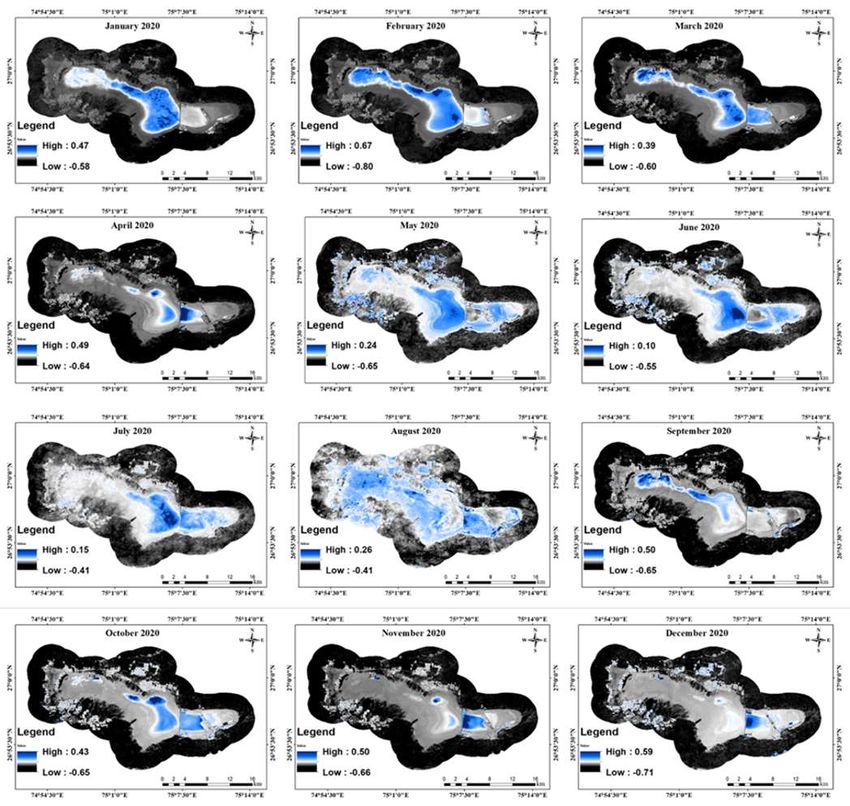
Preprints (www.preprints.org) | NOT PEER-REVIEWED | Posted: 13 October 2021                  doi:10.20944/preprints202110.0202.v1

                                    effective, and dynamic satellite images significantly different from traditional in situ
                                    measurements [10].
                                          Currently, 6,542 satellites are orbiting around Earth as of 1, 2021, out of which 3,372
                                    are operational and 3,170 satellites are non-operational providing petabytes of datasets
                                    [12]. Besides, space-borne satellites, other platforms like airplanes, ground-based plat-
                                    forms, Unmanned Aerial Vehicles, along with data from statistical, ecological, social, and
                                    geological constitute enormous volume of data also termed as Big Earth Data (BED) [13].
                                    BED requires high-end desktop computational facilities, developed infrastructure, huge
                                    storage capacities which limits the earth observation studies [14]. However, the availabil-
                                    ity of cloud computing platforms like Google Earth Engine (GEE) removes the above said
                                    obstacles since 2010 [15]. Its data repository is a collection of approximately 40 years of
                                    satellite imagery, at multiple Spatio-temporal scales [16]. It has wide range of data of
                                    Landsat series; National Oceanographic and Atmospheric Administration Advanced very
                                    high-resolution radiometer (NOAA AVHRR), Moderate Resolution Imaging Spectrome-
                                    ter (MODIS); Sentinel 1, 2, and 3, Advanced Land Observing Satellite (ALOS) and many
                                    more [16]. The only requirements are a simple desktop or laptop and internet connectivity
                                    for any time assessment and monitoring [17]. It eliminates the steps like raw satellite data
                                    downloading, pre-processing, layer stacking, mosaicking, clipping region of interest be-
                                    fore conducting the actual operations as it has JavaScript-based algorithms for each oper-
                                    ation [18]. This also facilitates importing and uploading of own vector and raster datasets
                                    and results can be exported from GEE in GeoTIFF format to own Google Drive account
                                    [19]. This enables minimum dependence on special remote sensing software such as Earth
                                    Resources Data Analysis System (ERDAS) Imagine and Environment for Visualizing Im-
                                    ages (ENVI), nevertheless, they are still needed for special functions that are not offered
                                    on GEE (like object-based image assessment) [16]. GEE has been widely explored for veg-
                                    etation mapping and monitoring such as global estimation of Fraction of Absorbed Pho-
                                    tosynthetically Active Radiation (FAPAR) [20], Leaf Area Index (LAI) [21], Canopy water
                                    content (CWC) [22], and Fraction Vegetation Cover (FVC) [23], for agricultural applica-
                                    tions like crop area mapping [24], crop yield estimation [25] and pests and diseases vul-
                                    nerability [16].
                                          However, this has been quite less explored for saline wetland application. Remote
                                    sensing images have been used to extract water bodies including several methods like
                                    single band density slicing [26], supervised [27] and unsupervised classification [28] and
                                    spectral water indexes [29]. However, among all these methods, index-based method is
                                    widely accepted due to its efficient and user-friendly process [27]. At first, Normalized
                                    Difference Water Index (NDWI) was proposed by [30] using the green and Near Infrared
                                    (NIR) bands of satellite images as waterbodies have strong absorbability and strong ab-
                                    sorbability and low radiation in the range from visible to infrared wavelengths. [31] mod-
                                    ified NDWI and named it MNDWI by substituting original NIR band with shortwave-
                                    infrared (SWIR) band to decrease commission errors in vegetation, built-up, and soil. Fur-
                                    ther, [32] developed the Automated Water Extraction Index (AWEI) which remove mis-
                                    classification of shadow as water, by using multiple spectral bands. Tasseled Cap Wetness
                                    (TCW) index has also been used for water studies [33]. Even though there are numerous
                                    indices available, NDWI has been the most accepted and widely used due to its simplicity,
                                    wide applicability to any water system and usability with any satellite datasets [34].
                                          The current study is conducted in the largest shallow saline Ramsar site of India. It
                                    is currently undergoing desiccation due to saltpan encroachment, illegal water extraction,
                                    brine theft and increasing urban pressure. As a result of which, whole ecology is at stake.
                                    So, to analyse the current position, this research article aimed to investigate the status of
                                    migratory birds and water availability. For this purpose, we performed research in phase.
                                    Firstly, we conducted bird survey for consistent three years, 2019, 2020 and 2021 and com-
                                    bined it with the literature survey data for long-term visiting trend analysis, migratory
                                    and resident ratio, feeding habit analysis and ecological diversity index calculation. Sec-
                                    ondly, we examined the monthly status of wetland for our survey period using NDWI in
                                    Google Earth Engine platform. This paper is divided into five sections. The first section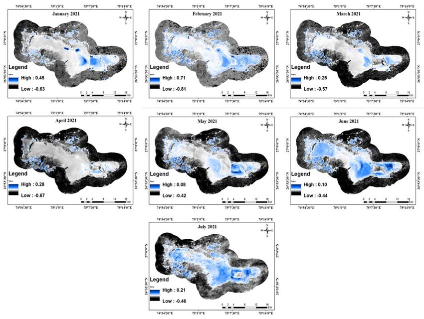
Preprints (www.preprints.org) | NOT PEER-REVIEWED | Posted: 13 October 2021                   doi:10.20944/preprints202110.0202.v1

                                    provides a brief overview of global status of saline lakes, developmental phases of remote
                                    sensing from desk computing to cloud computing and further applicability of NDWI. Sec-
                                    ond section elaborates on the study area, and methodology followed for bird and wetland
                                    status. Third section showcases the results obtained. Fourth section discusses the whole
                                    results and further section five concludes the research.

                                    2. Materials and Methods

                                    2.1   Study area

                                           Sambhar Salt Lake (26⁰ 52′ to 27⁰ 02′ N; 74⁰ 54′ – 75⁰ 14′ E) is a playa wetland located
                                    towards the east of Thar desert (Figure 1) surrounded by Aravali hill ranges of India [35].
                                    It is located 80.7 km away from Jaipur, the state capital of Rajasthan via National Highway
                                    48 and Rajasthan State Highway 57 [36]. In 1961, the Government of India (GoI) took over
                                    this region on a 99-year lease under the Ministry of Commerce and Industry Salt produc-
                                    tion, as India exports approximately 230 million tons of salt to global market after China
                                    and USA, to 198 countries like Japan, Bangladesh, Qatar, Indonesia, South and North Ko-
                                    rea, Malaysia, U.A.E, and Vietnam [10]. Being an inland wetland, it is 230 km2 (22.5 km in
                                    length and 3-1 km in width) [37]. A 5.16 km long dam is built for reservoir (77 km2) and
                                    wetland area (113 km2) [38]. Its saline character is contributed by the presence of salts of
                                    sodium, calcium, potassium, and magnesium cations and chloride, carbonate, bicar-
                                    bonate, and sulphate anions [39]. It seems white in areas with rich salt content; grey with
                                    less salt, and brown with no salt content. Being in semi-arid climatic zone, it receives
                                    about 500 mm rainfall during monsoon (July-September), has water during winter season
                                    (October- March) when the temperature is between 11 ⁰C to 24.4 ⁰C [40]. It almost dries
                                    out during summer season (April-June) when temperature rises to 40.7 ⁰C. It is also a shal-
                                    low lake with vertical depth ranging from 3 m to 0.6 m during monsoon to summer sea-
                                    sons [41]. Its water system is supported by ephemeral streams like Mendha, Kharian, Rup-
                                    nagar, Khandel forming the catchment of 5,520 km2 [42]. This amazing site is one of the
                                    most important visiting grounds for migratory waterbirds on the East Asian, Central
                                    Asian, and East African flyways declared as Ramsar site on 23 March 1990 and it is also
                                    an Important Bird Area [43]. There are about 1 lakhs waterbird primarily flamingo over-
                                    wintering in this lake and most of them are distributed in the saltpan areas as there is a
                                    little water left in the natural wetland area [44]. The water level of this lake is decreasing
                                    due to illegal saltpan encroachment [10]. Moreover, it also provides shelter to rich floral
                                    diversity such as species of 37 herbs, 14 shrubs, 14 trees, 15 grass, 6 chlorophyceae, 25
                                    Cyanophyceae and 7 Bacilariophyceae [45]. Hence, regular monitoring of waterbirds and
                                    their distribution along with mapping their habitats in entire flyways are necessary for
                                    their conservation.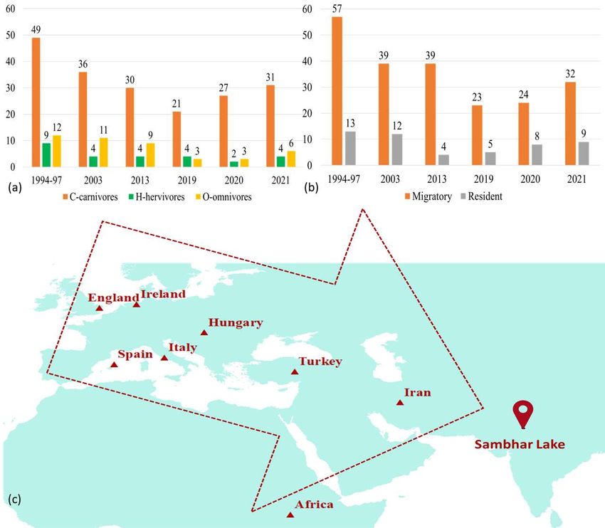
Preprints (www.preprints.org) | NOT PEER-REVIEWED | Posted: 13 October 2021                 doi:10.20944/preprints202110.0202.v1

                                        Figure 1. Study area. (a) is India; (b) is Rajasthan with three states and (c) is True
                                    Colour Composite of Sambhar Lake of 8 January 2021 with birds’ survey points.

                                         2.2   Bird census data

                                          We carried out 3 surveys for 3 days each during the wintering season of 2019, 2020
                                    and 2021, every third week from January to second week of February when the migratory
                                    birds visit the lake. The wetland survey included both the natural wetland area as well as
                                    saltpan areas. Bird counting was done on barefoot for some inaccessible sites while other
                                    sites were visited using vehicles. 10 observation points were used, from which the bird
                                    censuses were conducted. To avoid two-fold counting, when a flock of birds flew away
                                    into any section, it was not recorded. Censuses were carried out using binoculars and
                                    camera. Surveys were carried out during morning period when birds are most active. This
                                    was carried for almost three hours (6:00 to 10:00 AM; GMT + 5:30). Species identification
                                    and their foraging habitat were recorded using Asian Waterbird Census (AWC) given
                                    form. As Sambhar Lake has almost 360 m above mean sea level and is surrounded by
                                    Aravalli hill range in the outer boundary of the lake, there are no visual topographic hin-
                                    drance for the survey. Surveys were conducted by the same volunteers to avoid variation.
                                    The availability of time-series data from literature is scare with non-uniform patterns.
                                    However, we selected for the years 1994-97 [46], 2003 [47], 2013 [48]. These censuses were
                                    mostly conducted during winter season which matched our study period.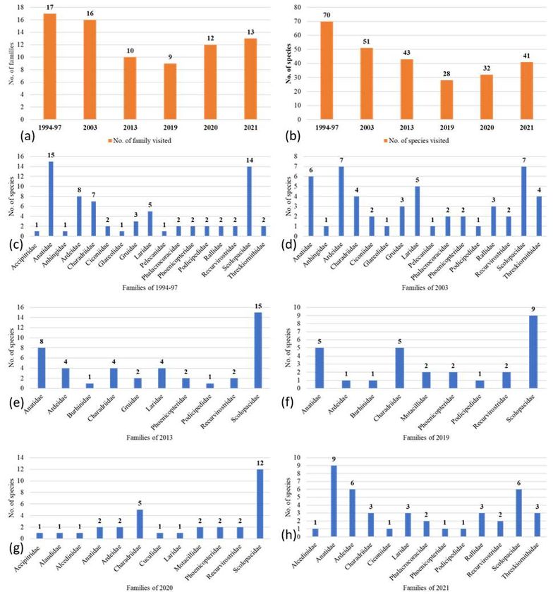
Preprints (www.preprints.org) | NOT PEER-REVIEWED | Posted: 13 October 2021                 doi:10.20944/preprints202110.0202.v1

                                    2.3   Satellite data

                                         Sentinel-2 mission was launched in 2015 by European Space Agency (ESA). It pro-
                                    vides open access to high spatial resolution optical and microwave data. Compared to the
                                    oldest satellite series Landsat, it provides images with more spectral bands higher spatial
                                    and temporal resolutions, and wider swath. Thereby it has wide range of applicability in
                                    the fields of land monitoring [49], vegetation [50], agricultural [51], water [52], and soil
                                    research [53]. The Sentinel-2 data contain 13 spectral bands representing Top of Atmos-
                                    pheric (TOA) reflectance scaled by 10000 [54]. Additionally, three Quality Assurance (QA)
                                    bands are available among which one (QA60) is a bitmask band with cloud mask infor-
                                    mation [55]. Each Sentinel-2 product set (zip archive) contains multiple granules which
                                    are individual assets in GEE [56]. Sentinel-2 has the format as COPERNI-
                                    CUS/S2/20211005T002653_ 20211231T102149_T56MNN as a GEE asset [57]. The first nu-
                                    meric part represents the data acquisition date and time, the second part signifies the
                                    product generation date and time, and the final six-character string represents unique
                                    granule identifier showing its UTM grid reference. For this study, the Level-2 data found
                                    in the collection of COPERNICUS/S2_SR were accessed for three years from 2019 to 2021
                                    from GEE.

                                    2.4   Google Earth Engine
                                         Sentinel-2 images from 2019 to 2021 have been assessed using functions (Table. 1). To
                                    reduce the effect of cloud cover, there are two removal techniques available: (1) GEE al-
                                    gorithm based on sorting algorithm in which images having less than 20% cloud cover are
                                    sorted, (2) GEE algorithm based on pixels method in which it assigns a cloud score to
                                    individual pixel and selects the lowest available range of cloud scores and then computes
                                    per-band percentile values from the selected pixels [58]. Here, we have used the second
                                    method along with QA60 algorithm for updating cloud cover mask. Then, NDWI was
                                    calculated using the respective function and visualized it in GEE.

                                    2.5   Normalized Difference Water Index

                                         The water index is based on the spectral features of water so that it can differentiate
                                    between water and non-water classes, and then extract water pixels according to the suit-
                                    able threshold. [30] stated that values of NDWI greater than zero represent water surfaces,
                                    while values less than, or equal, to zero represent non-water surfaces. Vegetation and soil
                                    characteristics usually have zero to negative values and are suppressed. The NDWI is cal-
                                    culated using Eq. (1) where Band 2 is the TOA green light reflectance and Band 4 is the
                                    TOA near-infrared (NIR) reflectance.
                                         NDWI= ((Green-NIR))/((Green+NIR))                                       (Equation 1)
                                         For Sentinel 2 data, band 3 is the green band and band 8 is the NIR band.

                                    2.6   Exporting

                                          The water surface extraction algorithm was used in the GEE platform every month.
                                    It identified the parts of lake with and without water. Then, this NDWI for each month
                                    was exported to google drive using java code and downloaded in .tif format. In Arc GIS,
                                    these indices outputs were reclassified into 5 classes to find the actual water spread area
                                    of the lake and finally map composed. The comprehensive methodology is shown in Fig-
                                    ure 2 below.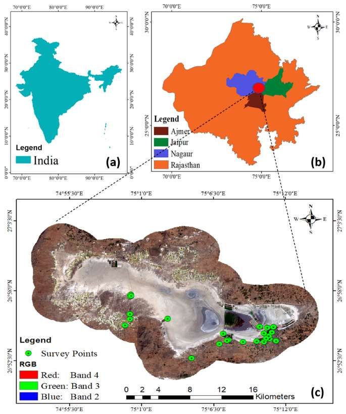
Preprints (www.preprints.org) | NOT PEER-REVIEWED | Posted: 13 October 2021                     doi:10.20944/preprints202110.0202.v1

                                             Figure 2. Methodology

                                             Table 1. List of Google Earth Engine functions used.
                    S.               Functions                                              Purposes

                   No.

                       1   ee.ImageCollection                To select satellite for which data will be used

                       2   ee.Date                           To define date for which data will be selected

                       3   .filterMetadata                   To filter metadata for which image will be selected

                       4   .filterBounds                     To define region of interest

                       5   .clip                             To clip region of interest

                       6   .sort                             To define cloud cover

                       7   .mask                             To mask cloudy image

                       8   Map.centerObject                  To display median of selected image

                       9   Map.addLayer                      To display image

                  10       image.select                      To select the desired bands

                  12       img.normalizedDifference          To calculate NDWI

                  13       .select                           To select desired NDWI image
Preprints (www.preprints.org) | NOT PEER-REVIEWED | Posted: 13 October 2021 doi:10.20944/preprints202110.0202.v1
14 .rename To rename the output image
15 Export.image.toDrive To export final output to drive
3. Results
3.1 Bird status
3.1.1 Trend analysis
From the combined results of literature and author’s survey, it is calculated that in
total as shown in Figure 3 (a &b), 97 species belonging to 23 families have visited the lake
since 1994. These families are Anhingidae, Accipitridae, Alaudidae, Alcedinidae, Anati-
dae, Ardeidae, Burhinidae, Charadriidae, Ciconiidae, Cuculidae, Glareolidae, Gruidae,
Ibidorhynthidae, Laridae, Motacillidae, Pelecanidae, Phalacrocoracidae, Phoenicopteri-
dae, Podicipedidae, Rallidae, Recurvirostridae, Scolopacidae, Threskiornithidae. Among
these, 9 species belong to Near Threatened, 3 vulnerable, 2 endangered and 77 least con-
cern as per IUCN Red List.
70 species of 17 family visited in between 1994-1997 (Figure 3 c). They are Accipitri-
dae (1), Anatidae (15), Anhingidae (1), Ardeidae (8), Charadriidae (7), Ciconiidae (2),
Glareolidae (1), Gruidae (3), Laridae (5), Pelecanidae (1), Phalacrocoracidae (2), Phoe-
nicopteridae (2), Podicipedidae (2), Rallidae (2), Recurvirostridae (2), Scolopacidae (14),
Threskiornithidae (2). Species of 6 families which belong to Alaudidae, Alcedinidae,
Burhinidae, Cuculidae, Ibidorhynthidae, and Motacillidae were absent. 51 species of 16
families visited in 2003 (Figure 3 d). They are Anatidae (6), Anhingidae (1), Ardeidae (7),
Charadriidae (4), Ciconiidae (2), Glareolidae (1), Gruidae (3), Laridae (5), Pelecanidae (1),
Phalacrocoracidae (2), Phoenicopteridae (2), Podicipedidae (1), Rallidae (3), Recurviros-
tridae (2), Scolopacidae (7), Threskiornithidae (4). Species which belong to 7 families
Alaudidae, Accipitridae, Alcedinidae, Burhinidae, Cuculidae, Ibidorhynthidae, and Mo-
tacillidae were absent. 43 species of 10 families visited in 2013 (Figure 3 e). They are Anat-
idae (8), Ardeidae (4), Burhinidae (4), Charadriidae (2), Gruidae (4), Laridae (2), Phoe-
nicopteridae (1), Podicipedidae (2), Recurvirostridae (15) and Scolopacidae (1). Species
which belong to 13 families Anhingidae, Accipitridae, Alaudidae, Alcedinidae, Ciconi-
idae, Cuculidae, Glareolidae, Ibidorhynthidae, Motacillidae, Pelecanidae, Phalacrocorac-
idae, Rallidae, and Threskiornithidae are absent.
28 species of 9 families visited in 2019 (Figure 3 f). They are Anatidae (5), Ardeidae
(1), Burhinidae (5), Charadriidae (2), Motacillidae (2), Phoenicopteridae (1), Podicipedidae
(2), Recurvirostridae (9) and Scolopacidae (1). Species which belong to 14 families Anhin-
gidae, Accipitridae, Alaudidae, Alcedinidae, Ciconiidae, Cuculidae, Glareolidae, Gruidae,
Ibidorhynthidae, Laridae, Pelecanidae, Phalacrocoracidae, Rallidae and Threskiornithi-
dae are absent. 32 species of 12 families visited in 2020 (Figure 3 g). They are Accipitridae
(1), Alaudidae (1), Alcedinidae (2), Anatidae (2), Ardeidae (5), Charadriidae (1), Cuculidae
(1), Laridae (2), Motacillidae (2), Phoenicopteridae (2), Recurvirostridae (12), and
Scolopacidae (1). Species which belong to 11 families like Anhingidae, Burhinidae, Cico-
niidae, Glareolidae, Gruidae, Ibidorhynthidae, Pelecanidae, Phalacrocoracidae, Podici-
pedidae, Rallidae, and Threskiornithidae are absent. 41 species of 13 families visited in
2021 (Figure 3 h). They are Alcedinidae (9), Anatidae (6), Ardeidae (3), Charadriidae (1),
Ciconiidae (3), Laridae (2), Phalacrocoracidae (1), Phoenicopteridae (1), Podicipedidae (3),
Rallidae (2), Recurvirostridae (6), Scolopacidae (3) and Threskiornithidae (1). Species
which belong to 10 families like Anhingidae, Accipitridae, Alaudidae, Burhinidae, Cucu-
lidae, Glareolidae, Gruidae, Ibidorhynthidae, Motacillidae, and Pelecanidae are absent.
Details of bird analysis is given in Table S1.Preprints (www.preprints.org) | NOT PEER-REVIEWED | Posted: 13 October 2021 doi:10.20944/preprints202110.0202.v1
Figure 3. showing temporal graphs of bird presence/absence results. (a) and (b) show
family and species wise and (c-h) show class-wise distribution.
3.1.2 Feeding habit analysis
From Figure 4 a, it is clear that Sambhar Lake always attracts a greater number of
carnivores birds as compared to herbivores and omnivores. In between 1994-97, total of
70 birds visited the lake, out of which 46 species were carnivores, 8 species were herbi-
vores, and 16 species were carnivores. In 2003, out of total 51 bird species, 36 were carni-
vores, 4 were herbivores and 11 were omnivores. In 2013, out of total 43 species, 30 were
carnivores, 4 were herbivores and 9 were omnivores. In 2019, out of total 28 species, 21
were carnivores, 4 were herbivores and 3 were omnivores. In 2020, out of total 32 species,
26 species were carnivores, 2 species were herbivores, and 4 species were omnivores. In
2021, out of total 41 species, 28 species were carnivores, 4 were herbivores and 9 were
omnivores. Carnivores birds visit this lake to feed upon fishes, eggs, small mammals, in-
sects, reptiles, frogs, worms, crustaceans, mollusks, snails, amphibians, insect larvae,
snakes, lizards, spiders, mice, grasshoppers, crickets, flies, moths, nestling birds, earthPreprints (www.preprints.org) | NOT PEER-REVIEWED | Posted: 13 October 2021 doi:10.20944/preprints202110.0202.v1
worms, cray fishes, bees, tadpoles, leeches, clams, mussels, turtles, caterpillars, beetles,
termites, ants, midges, locusts, grubs, mantids, stick insects, cicadas, maggots, cyprinids,
pikes, roaches, eels, perches, burbots, sticklebacks, muddy loaches, shrimps, offal and her-
bivores birds feed upon seeds, roots tubers, parts of plants, grasses, aquatic plants, seeds,
grains, various grasses, oats, wheat, barley, leaves, cereal stubbles, growing crops, nuts,
rice, sweet corn, and roots. Omnivores birds eat either of the available food.
3.1.3 Migratory pattern analysis
From the Figure 4 b, it is observed that there are more migratory birds than the resi-
dent birds of this lake. Among the total 70 birds visited during 1994-97, 57 species were
migratory and 13 were resident. In 2003, among 51 species, 39 are migratory and 12 are
resident species. In 2013, out of total 43 species, 39 are migratory and 4 are resident species.
In 2019, out of total 28 species, 23 are migratory and 5 are resident species. In 2020, out of
total 32 species, 24 are migratory and 8 are resident species. In 2021, out of total 41 species,
32 are migratory and 9 are resident species. All the migratory birds visited to the lakes
primarily from but not limited to European countries like Iceland, England, Ireland, Hun-
gary, Italy, Spain, Turkey, Africa, and Iran during winter season for resting, roosting, and
breeding as shown in Figure 4 c.
Figure 4. (a) shows feeding habit, (b) shows migratory/resident type and (c) major
visiting countries.Preprints (www.preprints.org) | NOT PEER-REVIEWED | Posted: 13 October 2021 doi:10.20944/preprints202110.0202.v1
3.1.4 Ecological diversity index
Two ecological species diversity indices have been calculated (Table 2). They are
Shannon-Weiner and Simpson diversity for the year of our study period (2019-2021). The
values of Shannon-Weiner index are 2, 1.09, 3.07 for 2019, 2020 and 2021 respectively. The
values of Simpson index are 0.21, 0.42, and 0.07 for 2019, 2020 and 2021 respectively.
Table 2. Ecological Diversity Index.
Year Shannon-Weiner index Simpson index
2019 2 0.21
2020 1.09 0.42
2021 3.07 0.07
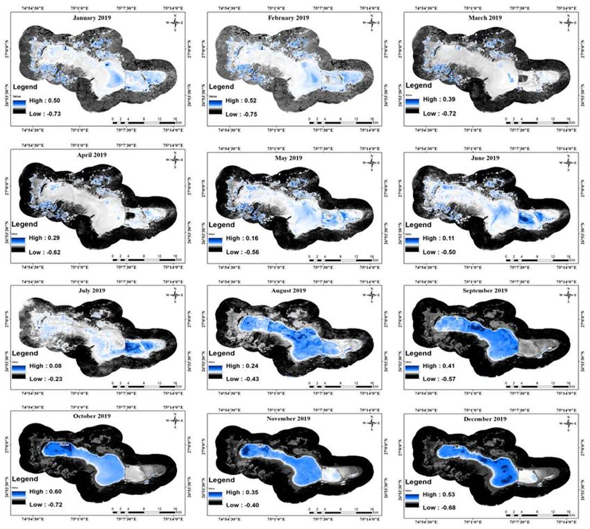
3.2 2019
In the year 2019 (Figure 5), the highest NDWI value for the whole year was 0.6 in
October and lowest was 0.08 in July. During winter season (January-March and October
to December), the highest value was 0.6 in October and 0.35 in November. During summer
season (April to June), highest was 0.29 in April and 0.11 in June. During monsoon (July
to September), the highest value was 0.41 in September and 0.08 in July.
Figure 5. NDWI maps of 2019.
3.3 2020Preprints (www.preprints.org) | NOT PEER-REVIEWED | Posted: 13 October 2021 doi:10.20944/preprints202110.0202.v1
In the year 2020 (Figure 6), the highest NDWI value for the whole year was 0.67 in
February and lowest was 0.1 in June. During winter season (January-March and October
to December), the highest value was 0.67 in February and 0.39 in March. During summer
season (April to June), highest was 0.49 in April and 0.1 in June. During monsoon (July to
September), the highest value was 0.5 in September and 0.15 in July.
Figure 6. NDWI maps of 2020.
3.4 2021
In the year 2021 (Figure 7), the highest NDWI value for the year until July was 0.71
in February and lowest was 0.1 in June. During winter season (January-March), the high-
est value was 0.71 in February and 0.26 in March. During summer season (April to June),Preprints (www.preprints.org) | NOT PEER-REVIEWED | Posted: 13 October 2021 doi:10.20944/preprints202110.0202.v1
highest was 0.28 in April and 0.08 in June. Cannot be compared as the data is available for
only July moth with value 0.21.
Figure 7. NDWI maps of 2021.
Table 1. This is a table. Tables should be placed in the main text near to the first time they are
cited.
Title 1 Title 2 Title 3
entry 1 data data
entry 2 data data 1
4. Discussion
In the present article, we investigated the wetland and migratory bird status for 2019,
2020 and 2021 accompanied by the literature bird survey data. We analyzed the trend
analysis, feeding habits and migratory whether there is any shift in visiting pattern of
migratory birds to the study area. We addressed the research question like which birds
used to come during last decades and now which birds are coming, which feeding habit
birds used to come and is there any shift, what was the ratio of migratory versus resident
birds and also to identify whether this lake supports any IUCN listed bird. The monthly
status of wetland was also integrated. We conducted bird census consistently for three
years during winter season to collect primary data. We used literature as secondary source
of data for identifying bird details in previous years and Arc GIS software for preparing
field visit plans and identifying sampling locations. We used Sentinel 2 B satellite data ofPreprints (www.preprints.org) | NOT PEER-REVIEWED | Posted: 13 October 2021 doi:10.20944/preprints202110.0202.v1
2021 for preparing study area map and field visiting map of 2021 January. We found re-
sults to be very depressing. Since last decades there has been a decreasing trend of migra-
tory birds visiting the lake. Birds of many families have stopped visiting. Numerous IUCN
listed birds used to come have also stopped coming to the lake. Due to continuous shrink-
age of wetland, there is little water to support aquatic life forms which are foundation of
complex food web. This is distinctly reflected in the decreasing trend of birds. The field
photographs are shown in Figure 8 below in which Figure 8 a-c represent seasonal change
of lake colour, 8 d and 8 e showcase flocks of flamingo and common ruff respectively and
8 f show our bird census team with Asian Waterbird Census.
It is disheartening to state that the trend of visiting birds has consistently been de-
creasing pattern till 2019. During the monsoon period of 2019, the lake received heavy
rainfall after 30 years [59] which helped to revive the water level. Shockingly, this lake
encountered first-ever avian botulism in its history [44]. It was observed on 13 November
2019 by some tourists. In this incidence more than forty thousand migratory birds, pri-
marily Northern Shoveler died [44]. To avoid any human infection, the salt extraction ac-
tivity was legally stopped for nearly two months (November, December, and January)
[44] which helped to retain the water level during these months as shown in Figures of
wetland maps observed using GEE. Meanwhile, COVID-19 was also scaring the country
and India had its longest countrywide shutdown due to COVID-19 from March to May
2020. This completely restricted any sort of economic activity within the lake. This further
helped the water retention in the lake even during the drying months (April-May) as
shown in result section. This prolonged availability of water in the lake is reflected in the
increasing pattern for the years 2020 and 2021 bird censuses.
Analyzing the temporal trend of birds, it is observed that during 1994, the lake wel-
comed 70 species which belong to 17 families which further reduced to meagerly 28 spe-
cies of 9 families in 2019. The most dominating families used to be Anatidae and
Scolopacidae. They combinedly accounted for 41.4% which reduced to 21.4% in 2019.
Though consistently Scolopacidae maintained to be the dominating family till 2020, in
2021 it was second dominating family. During 1994-97, out of total 15 birds of Anatidae,
13 were migratory birds. Among these 13, 8 were omnivorous and 5 were herbivorous.
Among the two resident birds 1 was omnivorous and other was herbivorous. The point
of concern is for Common pochard, being a migratory bird, currently under vulnerable
category of IUCN red list appeared in 1994-97 but were further not identified until 2020
survey. Though it reappeared only in 2020, again was absent in 2021 survey. Other birds
of this family which also have irregular visiting patterns to this lake are Ruddy shelduck,
Cotton pygmy goose, Gadwall, Eurasian wigeon, Mallard, Garganey, Red-crested po-
chard, Common pochard, and Tufted duck.
Focusing on Scolopacidae, out of 14 birds that visited, all were migratory birds and
among these 13 were carnivorous and 1 omnivorous. In this family, two species Black-
tailed godwit and Curlew sandpiper are under Near Threatened category. Interestingly
the first bird has been consistently recorded but the later bird has further never seen indi-
cating a dubious state for this wetland existence. Common snipe was recorded in 1994
and 2003 only. Further, only 1 Pin-tailed snipe was recorded in 2020. Eurasian whimbrel
and Sanderling were never recorded in subsequent years. Species like Broad-billed sand-
piper, green sandpiper, Wood sandpiper, red phalarope, and Ruddy turnstone which
were absent in 1994-97 phase were identified during our survey periods in different years.
Additionally, considering other families Egyptian vulture of Accipitridae family, which is
also an endangered listed bird never recorded after 1994-97 survey, however, in 2020,
Western Marsh-Harrier, another species of this family was observed.
Anhingidae (Darter, near threatened), Glareolidae (Collared pratincole), Gruidae
(Sarus crane, Demoiselle crane, and Common crane) and Pelecanidae (Great white peli-
can) almost disappeared after 2003 and were never recorded further. Families Ciconiidae
(Painted stork, near threatened and Black stork), Phalacrocoracidae (Little Cormorant and
Great cormorant), Rallidae (purple moorhen was never found again, Eurasian coot and
Common moorhen were found again, and White-breasted Waterhen was for the first timePreprints (www.preprints.org) | NOT PEER-REVIEWED | Posted: 13 October 2021 doi:10.20944/preprints202110.0202.v1
observed in 2021), and Threskiornithidae (Glossy ibis, Eurasian spoonbill, Red-naped Ibis,
and Oriental white ibis) like reappeared after revival of the lake water during 2020-2021.
Families like Alaudidae, Alcedinidae (White-breasted Kingfisher), Cuculidae (Greater
Coucal), and Motacillidae (White Wagtail, Grey Wagtail, and White-browed Wagtail) ap-
peared for the time during our survey period only. Some families have been persistently
visiting the lake are Anatidae, Ardeidae, Charadriidae, Laridae, Phoenicopteridae, Podici-
pedidae, Recurvirostridae, and Scolopacidae, however not all the species consistently vis-
ited.
To emphasize feeding habits, it is clear that lake has always been dominated by car-
nivores, followed by omnivores and least by herbivores. The trophic structure of this lake
starts with the phytoplankton which survives in the lake during monsoon to winter sea-
son [60]. The lake receives rainfall of about 500 mm from July to October during monsoon
season. During monsoon, the vital abiotic factors regulating its ecosystem like oxygen
level is high, whereas salinity, alkalinity, temperature, and brine density are low [61]. Ox-
ygen level starts decreasing and other parameters start increasing towards winter season
up to March. These shift in abiotic factors from monsoon to winter also leads to shifting
in biotic factors like phytoplankton, zooplankton, insect, crustacea, protozoa, rotifer and
other vertebrates and invertebrates (Shukla and Bhatnagar, 2005). During monsoon, the
colour of the brine appears green to dark green (Figure 8a) due to presence of abundant
oligohaline organisms like cyanobacteria, algae, and diatoms [61]. These are prime food
for rich insects’ diversity of heteroptera. Sometimes it is also suitable for freshwater spe-
cies on dilution of brine [62].
Subsequently, it changes to orange (Figure 8 b) to dark pink colour (Figure 8 c) by the
end of winter season taken over by euryhaline organisms [60]. These oligohaline and eu-
ryhaline are also called true aquatic life forms for the lake. These favourable seasons ac-
companied by suitable abiotic condition at pH level 7 to 10 promote their sporulation,
germination and germling developments for phytoplankton [63]. Salinity ranges from
50 mg/l to 120 mg/l and brine density from 1.07 to 1.17 g/cm3 from monsoon to winter
season [64]. The lake supports rich biodiversity of vertebrates, invertebrates, phytoplank-
ton, and prokaryotes when the salinity is below 50 gm/l [62]. These are found towards the
shoreline of the lake. During summer season (April-June), when it increases to 100 gm/l
to 120 gm/l, there is shift in organisms by hygrophilic life forms like haloalkaliphilic sul-
phate reducing bacteria, Dunaliella spp., cyanobacteria, Archaea. Halophilic bacteria of the
lake are also categorized as chemoautotrophs, chemoheterotrophs, photoautotrophs, pho-
toheterotrophs and chemo-lithotrophs [62; 61; 37]. These rich primary producers form the
backbone of rich primary producer diversities with 14 protozoa, 15 rotifers, 45 crustacea
(Dermaptera: 29 and Coleoptera: 45) and 74 insect species [65].
With the further increase in salinity to above 200 gm/l, biodiversity is completely
limited to species of Dunaliella sp. and Archaea sp. only found in the core region of the
lake giving dark red colour to the brine accompanied by dead algal cells [66]. This lake
has always had one or the other life form during every season. However, during monsoon
to winter season it supports abundant freshwater body organisms to sightly haloal-
kaliphilic ones which attract lakhs of migratory birds from different countries [38]. Birds
are considered to be the most commonly accepted ecological indicator. Their decreasing
trend in this lake indicates the disturbance in the respective organisms of lower trophic
levels. Disturbance in the organism configuration is the visible result of changing abiotic
factors like pH, salinity, alkalinity, oxygen and carbon dioxide and disturbed landscape
variables wetland shape, size, patch, corridors and hydrological connectivity between
shoreline and core part of the lake [10]. All these factors primarily indicate the highly fluc-
tuating water level as shown in the monthly water index maps of 2019, 2020 and 2021
coinciding with our bird survey time frame.
If the maps of 2019 are observed, the lake is devoid of water during winter season,
for January, February, and March when it is expected to have water. During the dry
months of April, May and June, there is no water in lake. According to Naik and Sharma
(2021) the lake has been shrinking at a constant rate of 4.23% since 1963. Already 30% ofPreprints (www.preprints.org) | NOT PEER-REVIEWED | Posted: 13 October 2021 doi:10.20944/preprints202110.0202.v1
the lake has been converted to saline soil and saline soil to barren land. Illegal salt pan
encroachment, excessive groundwater extract using electrical pumps are the prime cause
of desiccating status of the lake. Additionally, increasing settlement areas, domestic and
commercial waste dumping, and other pollution are also putting urban pressure on the
lake [38]. As there used to be no water, it has often been used as vehicular testing sites
which cause noise pollution in the peripheral area (Kumar, 2005). Based on the wetland
status till January 2019, it has been predicted that the lake might be completely desiccated
by 2059 even losing its saline character [10]. This will ultimately reflect on the global level
ecological disconnectivity led by the migratory birds.
Surprisingly, after 30 years there was sufficient rainfall in the Rajasthan state during
monsoon period of 2019 which helped to retain its water level as seen in August to De-
cember maps. According to some local unpublished sources the lake had welcomed lakhs
of migratory birds, indicating a positive sign of revival of lake. Unfortunately, within this
period the lake also encountered first ever in its history, a massive avian botulism cata-
strophic event. Due to this event, all the economic activities were banned till the reason
for botulism was identified. This prohibited the illegal activities and helped more water
retention for January, February, March 2020 as compared to same period of 2019. Mean-
while, due to worldwide COVID-19 pandemic, there was complete shutdown from March
till May 2020. This helped to maintain the water level even during the summer months of
April, May, June, and July. However, from August 2020 onwards, after unlocking, the
condition has again started deteriorating as the economic activities were allowed. From
the maps of monsoon period of 2020 continuously till monsoon of 2021, the lake is again
desiccating. According to the Sambhar Salt Ltd, 77 km2 towards the east is allowed for
salt extraction and rest of the 113 km2 is allowed for ecological purposes, migratory birds
and groundwater recharge. But practically, every part of the lake has been encroached,
stealing brine worth 330 billion dollars in the global salt market. This might again reduce
the water level, and subsequently the visiting migratory birds.
High rainfall after 30 years, short term control over economic activities and COVID-
19 lockdown, combinedly helped to revive the water level without any capital investment.
These indicate that the lake has high resilience capacity and can be restored with little but
a proper conservation and management plan. We suggest a practically implementable
restoration plan for this lake. According to The Gazette of India, 26 September 2017, PART
II—Section 3—Sub-section (i), in context to Sambhar Lake, Sambhar Development Au-
thority (SDA) should be formulated. This authority should designate an expert each for
wetlands ecology, hydrology, fisheries, landscape planning and socioeconomics besides
one from civil society and shall meet at least thrice in a year. SDA should list out all the
activities allowed, regulated, or prohibited within Sambhar Lake. It should allocate
budget and human resources to this authority to ensure smooth functioning and encour-
age activities like ecological rehabilitation and rewilding of nature, research, environmen-
tal education and participation activities, habitat management and conservation of wet-
land-dependent species, community-based ecotourism with minimum construction activ-
ities, harvesting of wetlands products within regenerative capacity, integrating wetlands
as nature-based solutions for climate change mitigation and adaptation are likely to be
aligned with the “wise use”. SDA should strictly monitor the activities listed in 2017 rules
that prohibit within notified wetlands, such as the setting up of any industry and expan-
sion of existing industries, manufacture or handling or storage or disposal of construction
and demolition waste, solid waste dumping, discharge of untreated wastes and effluents
from industries, cities, towns, villages, and other human settlements. It must ensure pro-
hibition of any type of illegal salt pan encroachment and wetland conversion to non-wet-
land use. For this, SDA might also take necessary assistance from professional insti-
tute(s)/organization(s). With the help of remote sensing experts, hotspots for different
migratory birds and unique halophytes and halophiles be identified. Then, their eco-sen-
sitive buffer zones be mapped using remote sensing and GIS technology. Further, their
habitat suitability assessment be modelled with respect to different climatic scenarios.
These steps coupled with complete check of illegal salt pan encroachment and excessPreprints (www.preprints.org) | NOT PEER-REVIEWED | Posted: 13 October 2021 doi:10.20944/preprints202110.0202.v1
ground water extraction to maintain complete ecological integrity of the lake. These will
automatically support good quality of brine formation for both pan and kyars salt pro-
duced in this lake. This will help Govt. of India to overcome the loss of salt production.
It is widely believed that inland saline lakes are either salt-producing sites or a waste-
land. Though there are globally 200 inland temporary and permanent Ramsar sites [67]
still they are not considered to be conserved. These conceptions have already led to con-
version of world’s numerous large saline lakes like Aral Sea, Caspian Sea, Lake Urmia,
Lake Salton, Lake Utah, Dead Sea, and Lake Balkhash. Billion dollars business has col-
lapsed, lakhs of livelihoods have been lost, in addition to loss of habitats of migratory
birds, halo-tolerant vertebrates and invertebrates, recreational and educational sites.
Especially, our findings highlight the causal factors responsible for the desiccation of
this Ramsar site that might also be the causes of other lacustrine wetlands. It also provides
a novel approach towards regular monitoring of the lakes integrating Google Earth En-
gine. Taken together, our findings of previous studies point towards the urgent need to
conserve the rich biodiversity of inland saline wetlands, playa wetlands, shallow wet-
lands, sabkhas, salterns, saltpans, athalassohaline lakes and soda lakes of the world.
These ecosystems are the blue lifeline for semi-arid to arid regions and going to the alter-
native of freshwater bodies in the near future almost in every climatic zones. GEE replac-
ing the high-end desktop computational requirement with the cloud computation which
can be accessed in the field itself for real-time monitoring as well. Hence, this new ap-
proach of integration of cloud computation with the ecological datasets can fasten the
conservational networks during the United Nations Decade on Ecosystem Restoration
(2021-2030).
The only limitation of this study is that we have not gone for the soil and water qual-
ity tests. Assessment of physico-chemical and biological parameters during our survey
period of 2019-2021 would have given complete picture of trophic status of the lake. How-
ever, due to repeated country-wide lock down and shut down for COVID-19 pandemic
situation, authors could not achieve this target. However, this might not impact much as
the results are combined with the available literature. Future research may extend this
work by conducting species distribution modelling for keystone species like lesser fla-
mingo, machine learning techniques like Multivariate Adaptive Regression Splines
(MARS) for multiple species simultaneously, use of microwave datasets for bathymetric
analysis, integrated trophic status index, spectral library generation of haloalkaliphiles
using hyperspectral datasets, use of Artificial Intelligence and Internet of Things for water,
soil and brine quality monitoring.
Figure 8. Field photographs
5. Conclusions
The current study has been conducted in the largest shallow saline wetland of India,
Sambhar Lake. It is experiencing severe threat due to illegal saltpan encroachment, use of
illegal electric cables for excessive underground water extraction and stealing of brine
worth 330 billion dollars in the global salt market. Such activities are consistently degrad-
ing the ecosystem, creating imbalance at each trophic level from primary producer to ter-
tiary consumer level. This study aimed to analyze the status of migratory birds and the
water level of the wetland using integrative approach of ground survey and Google Earth
Engine. The comprehensive results showcase the blurred future of this amazing Ramsar
site, designated under criteria A due to its unique character. If urgent conservational steps
are not taken as discussed, it might be completely lost before its lease period (2059) as a
salt industry. This research will help to conserve this ecosystem. Due to COVID-19, food
type analysis could not be conducted. However, it did not impact much. Not only this
lake but there are also 148 such inland saline Ramsar sites and other unidentified sitesPreprints (www.preprints.org) | NOT PEER-REVIEWED | Posted: 13 October 2021 doi:10.20944/preprints202110.0202.v1
sharing this common fate of desiccation. They should be prioritized during the UN Dec-
ade on Ecosystem Restoration.
Supplementary Materials: Table S1 is attached below.
Author Contributions: Conceptualization, L.K.S.; methodology, R.N.; software, R.N.; validation,
R.N.; formal analysis, R.N.; investigation, L.K.; resources, L.K.; data curation, R.N.; writing—origi-
nal draft preparation, R.N.; writing—review and editing, L.K.S.; visualization, R.N.; supervision,
L.K.S.; project administration, L.K.S.; All authors have read and agreed to the published version of
the manuscript.”
Funding: Please add: “This research received no external funding”.
Data Availability Statement: This study did not report any data.
Acknowledgments: Authors express gratitude to Asian Waterbird Census and Wildlife Creatures
Organization (Phulera, Rajasthan) for primary bird data collection during 2019, 2020 and 2021. We
also thank Sambhar Salt Limited for providing permission to conduct research on the lake.
Conflicts of Interest: The authors declare no conflict of interest.
References
1. Zadereev, E., Lipka, O., Karimov, B., Krylenko, M., Elias, V., Pinto, I. S., Alizade, V., Anker, Y., Feest, A.,
Kuznetsova, D., Mader, A., Salimov, R., & Fischer, M. (2020). Overview of past, current, and future ecosystem and
biodiversity trends of inland saline lakes of Europe and Central Asia. Inland waters, 10(4), 438-452. DOI:
10.1080/20442041.2020.1772034
2. Wurtsbaugh, W. A., Miller, C., Null, S. E., DeRose, R. J., Wilcock, P., Hahnenberger, M., Howe, F. & Moore, J.
(2017). Decline of the world's saline lakes. Nature Geoscience, 10(11), 816-821.
3. Fukushi, K., Imai, E., Sekine, Y., Kitajima, T., Gankhurel, B., Davaasuren, D., & Hasebe, N. (2020). In situ formation
of monohydrocalcite in alkaline saline lakes of the valley of Gobi lakes: Prediction for Mg, Ca, and total dissolved
carbonate concentrations in Enceladus’ Ocean and alkaline-carbonate Ocean worlds. Minerals, 10(8), 669.
4. Hassani, A., Azapagic, A., D'Odorico, P., Keshmiri, A., & Shokri, N. (2020). Desiccation crisis of saline lakes: A
new decision-support framework for building resilience to climate change. Science of the Total Environment, 703,
134718.
5. Wang, X., Chen, Y., Li, Z., Fang, G., Wang, F., & Liu, H. (2020). The impact of climate change and human activities
on the Aral Sea Basin over the past 50 years. Atmospheric Research, 245, 105125.
6. Zhang, Y., Liang, J., Zeng, G., Tang, W., Lu, Y., Luo, Y., & Huang, W. (2020). How climate change and
eutrophication interact with microplastic pollution and sediment resuspension in shallow lakes: A review. Science of
the Total Environment, 705, 135979.
7. Connolly, R., Connolly, M., Carter, R. M., & Soon, W. (2020). How Much Human-Caused Global Warming Should
We Expect with Business-As-Usual (BAU) Climate Policies? A Semi-Empirical Assessment. Energies, 13(6), 1365.
8. Tussupova, K., Hjorth, P., & Moravej, M. (2020). Drying lakes: a review on the applied restoration strategies and
health conditions in contiguous Areas. Water, 12(3), 749.
9. Zhang, W. (2020). A brief review on restoration projects on Lake Superior coastal wetlands in Ontario, Canada
(Doctoral dissertation).
10. Naik, R., & SHARMA, L. (2021). Spatio-temporal modelling for the evaluation of an altered Indian saline Ramsar
site and its drivers for ecosystem management and restoration. bioRxiv.
11. Kolpakova, M. N., Gaskova, O. L., Naymushina, O. S., Karpov, A. V., Vladimirov, A. G., & Krivonogov, S. K.
(2019). Saline lakes of Northern Kazakhstan: Geochemical correlations of elements and controls on their accumulation
in water and bottom sediments. Applied Geochemistry, 107, 8-18.Preprints (www.preprints.org) | NOT PEER-REVIEWED | Posted: 13 October 2021 doi:10.20944/preprints202110.0202.v1
12. McDowell, J. C. (2020). The low earth orbit satellite population and impacts of the SpaceX Starlink constellation.
The Astrophysical Journal Letters, 892(2), L36.
13. Esch, T., Asamer, H., Bachofer, F., Balhar, J., Boettcher, M., Boissier, E., & Zeidler, J. N. (2020). Digital world meets
urban planet–new prospects for evidence-based urban studies arising from joint exploitation of big earth data,
information technology and shared knowledge. International journal of digital earth, 13(1), 136-157.
14. Yao, X., Li, G., Xia, J., Ben, J., Cao, Q., Zhao, L., & Zhu, D. (2020). Enabling the big earth observation data via cloud
computing and DGGS: Opportunities and challenges. Remote Sensing, 12(1), 62.
15. Gorelick, N., Hancher, M., Dixon, M., Ilyushchenko, S., Thau, D., & Moore, R. (2017). Google Earth Engine:
Planetary-scale geospatial analysis for everyone. Remote sensing of Environment, 202, 18-27.
16. Mutanga, O., & Kumar, L. (2019). Google earth engine applications.
17. Kennedy, R. E., Yang, Z., Gorelick, N., Braaten, J., Cavalcante, L., Cohen, W. B., & Healey, S. (2018).
Implementation of the LandTrendr algorithm on google earth engine. Remote Sensing, 10(5), 691.
18. Vos, K., Splinter, K. D., Harley, M. D., Simmons, J. A., & Turner, I. L. (2019). CoastSat: A Google Earth Engine-
enabled Python toolkit to extract shorelines from publicly available satellite imagery. Environmental Modelling &
Software, 122, 104528.
19. Wang, L., Diao, C., Xian, G., Yin, D., Lu, Y., Zou, S., & Erickson, T. A. (2020). A summary of the special issue on
remote sensing of land change science with Google earth engine.
20. Campos-Taberner, M., Moreno-Martínez, Á., García-Haro, F. J., Camps-Valls, G., Robinson, N. P., Kattge, J., &
Running, S. W. (2018). Global estimation of biophysical variables from Google Earth Engine platform. Remote Sensing,
10(8), 1167.
21. Pipia, L., Amin, E., Belda, S., Salinero-Delgado, M., & Verrelst, J. (2021). Green LAI Mapping and Cloud Gap-
Filling Using Gaussian Process Regression in Google Earth Engine. Remote Sensing, 13(3), 403.
22. Anchang, J. Y., Prihodko, L., Ji, W., Kumar, S. S., Ross, C. W., Yu, Q., & Hanan, N. P. (2020). Toward operational
mapping of woody canopy cover in tropical savannas using Google Earth Engine. Frontiers in Environmental Science,
8, 4.
23. Vermeulen, L. M., Munch, Z., & Palmer, A. (2021). Fractional vegetation cover estimation in southern African
rangelands using spectral mixture analysis and Google Earth Engine. Computers and Electronics in Agriculture, 182,
105980.
24. Liu, L., Xiao, X., Qin, Y., Wang, J., Xu, X., Hu, Y., & Qiao, Z. (2020). Mapping cropping intensity in China using
time series Landsat and Sentinel-2 images and Google Earth Engine. Remote Sensing of Environment, 239, 111624.
25. Cao, J., Zhang, Z., Luo, Y., Zhang, L., Zhang, J., Li, Z., & Tao, F. (2021). Wheat yield predictions at a county and
field scale with deep learning, machine learning, and google earth engine. European Journal of Agronomy, 123, 126204.
26. Ding, Z., Qi, N., Dong, F., Jinhui, L., Wei, Y., & Shenggui, Y. (2016). Application of multispectral remote sensing
technology in surface water body extraction. In 2016 International Conference on Audio, Language and Image
Processing (ICALIP) (pp. 141-144). IEEE.
27. Gautam, V. K., Gaurav, P. K., Murugan, P., & Annadurai, M. J. A. P. (2015). Assessment of surface water
Dynamicsin Bangalore using WRI, NDWI, MNDWI, supervised classification and KT transformation. Aquatic Procedia,
4, 739-746.
28. Dibs, H. (2018). Comparison of derived Indices and unsupervised classification for AL-Razaza Lake dehydration
extent using multi-temporal satellite data and remote sensing analysis. Journal of Engineering and Applied Sciences,
13(24), 1-8.
29. Fisher, A., Flood, N., & Danaher, T. (2016). Comparing Landsat water index methods for automated water
classification in eastern Australia. Remote Sensing of Environment, 175, 167-182.Preprints (www.preprints.org) | NOT PEER-REVIEWED | Posted: 13 October 2021 doi:10.20944/preprints202110.0202.v1
30. McFeeters, S.K. (1996). The use of normalized difference water index (NDWI) in the delineation of open water
features. International Journal of Remote Sensing. 17: 1425-1432.
31. Xu, H. (2006). Modification of normalised difference water index (NDWI) to enhance open water features in
remotely sensed imagery. Int. J. Remote Sens.
32. Feyisa, G.L.; Meilby, H.; Fensholt, R.; Proud, S.R. (2014). Automated Water Extraction Index: A new technique for
surface water mapping using Landsat imagery. Remote Sens. Environ. 140, 23–35.
33. Chen, C., Bu, J., Zhang, Y., Zhuang, Y., Chu, Y., Hu, J., & Guo, B. (2019). The application of the tasseled cap
transformation and feature knowledge for the extraction of coastline information from remote sensing images.
Advances in Space Research, 64(9), 1780-1791.
34. Watson, C. S., King, O., Miles, E. S., & Quincey, D. J. (2018). Optimising NDWI supraglacial pond classification on
Himalayan debris-covered glaciers. Remote sensing of environment, 217, 414-425.
35. Kaushik, G., & Raza, K. (2019). Potential of novel Dunaliella salina from sambhar salt lake, India, for
bioremediation of hexavalent chromium from aqueous effluents: An optimized green approach. Ecotoxicology and
environmental safety, 180, 430-438.
36. Singh, H., Kaur, M., Singh, S., Mishra, S., Kumar, S., Vemuluri, V. R., & Pinnaka, A. K. (2018). Salibacterium
nitratireducens sp. nov., a haloalkalitolerant bacterium isolated from a water sample from Sambhar salt lake, India.
International journal of systematic and evolutionary microbiology, 68(11), 3506-3511.
37. Sharma, L. K., Naik, R., & Pandey, P. C. (2020a). Efficacy of hyperspectral data for monitoring and assessment of
wetland ecosystem. In Hyperspectral Remote Sensing (pp. 221-246). Elsevier.
38. Sharma, L., Naik, R., & Raj, A. (2020b). Inland Saline Wetlandscapes: The Missing Links for 4th Ramsar Strategic
Plan (2016-2024) in India. In Spatial Information Science for Natural Resource Management (pp. 242-268). IGI Global.
39. Sharma, L. K., Naik, R., & Pandey, P. C. (2021). A Focus on Reaggregation of Playa Wetlandscapes in the Face of
Global Ecological Disconnectivity. Advances in Remote Sensing for Natural Resource Monitoring, 366-387.
40. Sar, A., Pal, S., Islam, S., Mukherjee, P., & Dam, B. (2021). An Alkali-Halostable Endoglucanase Produced
Constitutively by a Bacterium Isolated from Sambhar Lake in India with Biotechnological Potential. Proceedings of the
National Academy of Sciences, India Section B: Biological Sciences, 1-8.
41. Kumari, C. G. (2021). Taxonomic identification of some species of birds and water quality analysis of sambhar salt
lake.
42. Bairwa, H. K., Prajapat, G., Jain, S., Khan, I. A., Ledwani, L., Yadav, P., & Agrawal, A. (2021). Evaluation of UV-B
protection efficiency of mycosporine like amino acid extracted from the cyanobacteria Anabaenopsis sp. SLCyA isolated
from a hypersaline lake. Bioresource Technology Reports, 15, 100749.
43. Bhatia, N., Mahesh, D., Singh, J., & Suri, M. (2021). Bird-Area Water-Bodies Dataset (BAWD) and Predictive AI
Model for Avian Botulism Outbreak (AVI-BoT). arXiv preprint arXiv:2105.00924.
44. Jhajhria, A. (2020). A Review on the status of Sambhar Wetland bird tragedy.
45. Sharma, L.K, Divyansh, K., & Raj, A. (2019). A Maxent modelling with a geospatial approach for the Habitat
suitability of Flamingos in an Evanescing Ramsar site (Sambhar Lake, India) over the changing climatic scenarios.
46. Kumar, S. (2008). Conservation of Sambhar Lake - An Important Waterfowl Habitat and A Ramsar Site in India.
Taal 2007:The 12th World Lake Confrence:1509-1517, 1509–1517.
47. Shukla, S. K., & Bhatnagar, S.P. (2005). Check list of Sambhar Lake waterfowl in Inland Saline water
Ecosystem,Rajsthan,India. Bird Watchers, 5(3), 40–41.
48. Sharma, B. K., Kulshreshtha, S., & Rahmani, A. R. (2013). Faunal heritage of Rajasthan, India. In Faunal Heritage
of Rajasthan, India (pp. 1–525). https://doi.org/10.1007/978-3-319-01345-9You can also read