No 116 2021 Megacity's fingerprint in Chinese marginal seas - Joanna J. Waniek, Detlef E. Schulz-Bull, Birgit Gaye, Ralf Ebinghaus, Friederike ...
←
→
Page content transcription
If your browser does not render page correctly, please read the page content below
No 116 2021

Megacity’s fingerprint in Chinese marginal seas.

Joanna J. Waniek, Detlef E. Schulz-Bull, Birgit Gaye, Ralf Ebinghaus,
Friederike Kunz, Thomas Pohlmann, Kay-Christian Emeis (eds.)
"Meereswissenschaftliche Berichte" veröffentlichen Monographien und Ergebnis-
berichte von Mitarbeitern des Leibniz-Instituts für Ostseeforschung Warnemünde und
ihren Kooperationspartnern. Die Hefte erscheinen in unregelmäßiger Folge und in
fortlaufender Nummerierung. Für den Inhalt sind allein die Autoren verantwortlich.

"Marine Science Reports" publishes monographs and data reports written by scien-
tists of the Leibniz-Institute for Baltic Sea Research Warnemünde and their co-
workers. Volumes are published at irregular intervals and numbered consecutively.
The content is entirely in the responsibility of the authors.

Schriftleitung / Editorship: Dr. Sandra Kube
            (sandra.kube@io-warnemuende.de)

Die elektronische Version ist verfügbar unter / The electronic version is available on:
http://www.io-warnemuende.de/meereswissenschaftliche-berichte.html

                  © Dieses Werk ist lizenziert unter einer Creative Commons Lizenz
                  CC BY-NC-ND 4.0 International. Mit dieser Lizenz sind die
Verbreitung und das Teilen erlaubt unter den Bedingungen: Namensnennung - Nicht-
kommerziell - Keine Bearbeitung.

© This work is distributed under the Creative Commons License which permits to copy
and redistribute the material in any medium or format, requiring attribution to the
original author, but no derivatives and no commercial use is allowed, see:
http://creativecommons.org/licenses/by-nc-nd/4.0/

                               ISSN 2195-657X

Joanna J. Waniek1, Detlef E. Schulz-Bull1, Birgit Gaye2, Ralf Ebinghaus3, Friederike
Kunz1, Thomas Pohlmann4, Kay-Christian Emeis2,3 (eds): Megacity’s fingerprint in
Chinese marginal seas. Meereswiss. Ber., Warnemünde, 116 (2021),
doi:10.12754/msr-2021-0116

1 Leibniz
        Institute for Baltic Sea Research, Seestraße 15, D-18119 Rostock-
Warnemünde, Germany; 2 Institute of Geology, University of Hamburg, Bundesstraße
55, 20146 Hamburg, Germany; 3 Institute of Coastal Research, Helmholtz-Zentrum
Geesthacht Centre for Materials and Coastal Research, Max-Planck-Straße 1, 21502
Geesthacht, Germany; 4 Institute of Oceanography, University of Hamburg,
Bundesstr. 53, 20146 Hamburg, Germany

Corresponding author: joanna.waniek@io-warnemuende.de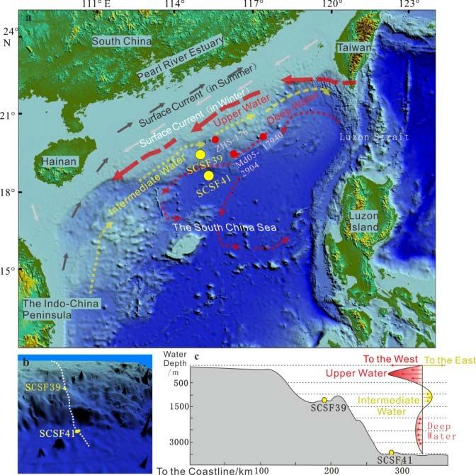
Meereswissenschaftliche Berichte
                  Marine Science Reports

                                          No. 116

            Megacity’s fingerprint in Chinese marginal seas

   Joanna J. Waniek1, Detlef E. Schulz-Bull1, Birgit Gaye2, Ralf Ebinghaus3, Friederike
   Kunz1, Thomas Pohlmann4, Kay-Christian Emeis2,3, Lutz Ahrens5, Christina Apel3,6,
 Jana-Sophie Appelt1, Helge W. Arz1, Célia P. M. Bento3, Kaixuan Chen7, Yunru Chen8,
   Zi Cheng7, Kirstin Dähnke3, Carina Deich1, Olaf Dellwig1, Kathrin Fisch1, Helena C.
   Frazão1, Chuancheng Fu9,10, Huayang Gan12, Yonghui Gao7, Patrick Grunert11, Chao
  Guo9, Ines Hand1, Gaowen He12,13, Tamara Hechemer11, Mengxi Hu12, Hanna Joerss3,
Jérôme Kaiser1, Marion Kanwischer1, Niko Lahajnar2, Ji Li7, Lianzhen Li9, Pingyuan Li12,
  Wenguo Li4, Yanan Li9, 14, Yanfang Li9,15, Yuan Li9, Lin Liu9,14,16, Ying Liu9, Jianfei Lu12,
   Yongming Luo9,10, Jan Maier2, Bernhard Mayer4, Frank Menger5, Tanja Naumann3,
   Yugen Ni12,13, Carolin Perkuhn2, Jassin Petersen11, Julian Pietralla11, Tina Sanders3,
    Anna Saupe11, Johanna Schmidt11, Mischa Schönke1, Thekla-Regine Schramm3,
  Linting Sun9, Xu Sun9,14, Dehao Tang12,13, Jianhui Tang9,15, Shichao Tian2, Chen Tu9,1,
   Fengping Wang7,8, Xinming Wang16, Maike Wilschnack1, Andreas Wittmann3, Zhen
  Xia12,13, Kuanxu Xiong9, Jie Yang10, Ruifeng Zhang7, Xinning Zhang9, Zhaoru Zhang7,
   Xiaomei Zhen9,14,16, Yisen Zhong7, Lei Zhou7, Meng Zhou7, Qian Zhou9, 1, Yiwu Zhu7

Author addresses:
1 Leibniz Institute for Baltic Sea Research Warnemünde, Seestraße 15, 18119 Rostock,
       Germany
2 Institute of Geology, University of Hamburg, Bundesstraße 55, 20146 Hamburg, Germany

3 Institute of Coastal Research, Helmholtz-Zentrum Geesthacht Centre for Materials and

       Coastal Research, Max-Planck-Straße 1, 21502 Geesthacht, Germany
4 Institute of Oceanography, University of Hamburg, Bundesstr. 53, 20146 Hamburg, Germany

5 Department of Aquatic Sciences and Assessment, Swedish University of Agricultural

       Sciences, Lennart Hjelms väg 9, 75651 Uppsala, Sweden
6 Federal Maritime and Hydrographic Agency (BSH), Bernhard-Nocht-Straße 78, 20359

       Hamburg, Germany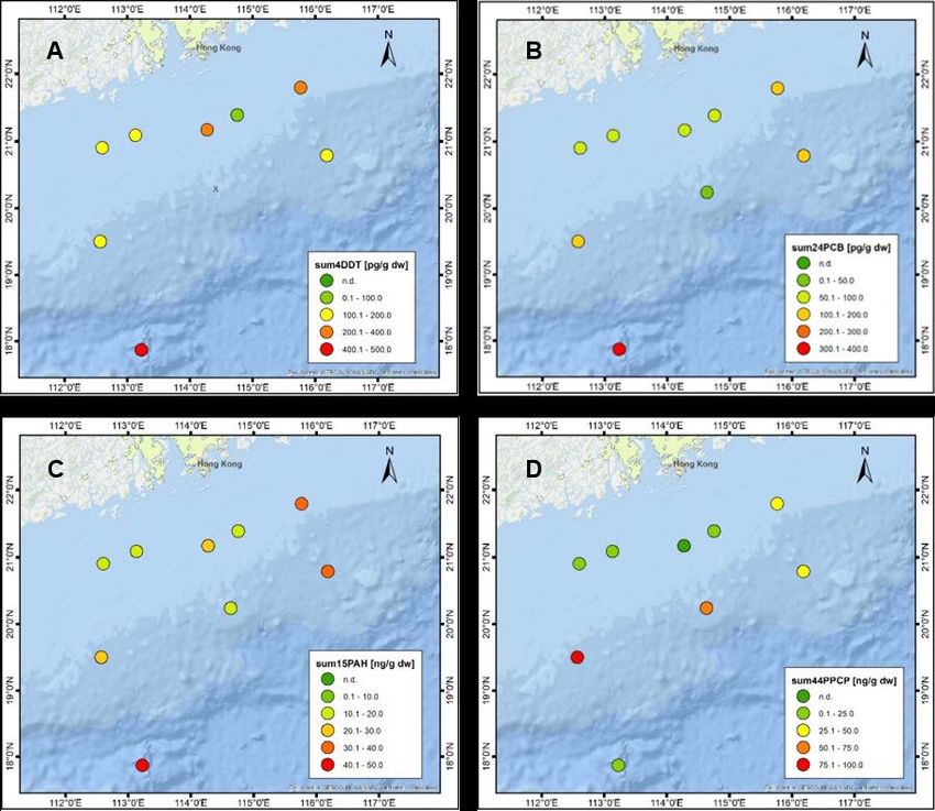
7 School of Oceanography, Shanghai Jiao Tong University, No. 1954 Huashan Road, Shanghai
        200030, PR China
8 State Key Laboratory of Microbial Metabolism, School of Life Sciences and Biotechnology,

        Shanghai Jiao Tong University, Shanghai 200240, PR China
9 CAS Key Laboratory of Coastal Environmental Processes and Ecological Remediation, Yantai

        Institute of Coastal Zone Research, Chinese Academy of Sciences (YIC-CAS), 17 Chunhui
        Road, Yantai 264003, PR China
10 CAS Key Laboratory of Soil Pollution and Pollution Remediation, Institute of Soil Science,

        Chinese Academy of Sciences, 71 East Beijing Road, Nanjing 210008, PR China,
11 Institute of Geology and Mineralogy, University of Cologne, Zülpicher Str. 49a, 50674

        Cologne, Germany
12 Guangzhou Marine Geological Survey, No. 188 Guanghai Road, Guangzhou 510075,

        PR China
13 Southern Marine Science and Engineering Guangdong Laboratory, 1119 Haibin Road,

        Guangzhou 511458, PR China
14 University of Chinese Academy of Sciences, Beijing 100049, PR China

15 Center for Ocean Mega-Science, Chinese Academy of Sciences, Qingdao 266071, PR China

16 State Key Laboratory of Organic Geochemistry, Guangzhou Institute of Geochemistry,

        Chinese Academy of Sciences, 511 Kehua Street, Guangzhou 510640, PR China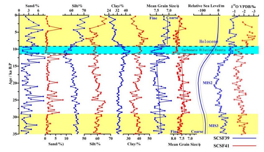
Table of Content
Kurzfassung                                                                                 7
Summary                                                                                    9
1     Preface                                                                              11
2     Physical forcing and the pattern of emerging pollutants in South China Sea           14
2.1   Surface Kuroshio Intrusion into the South China Sea derived from Satellite
      Geostrophic Streamlines (Yisen Zhong, Meng Zhou, Joanna J. Waniek, Lei Zhou and
      Zhaoru Zhang)                                                                   14
2.2   Statistical characteristics of mesoscale eddies on the continental slope in the
      northern South China Sea (Meng Zhou, Zi Cheng, Yisen Zhong and Zhaoru Zhang)         15
2.3   Numerical simulation of Mangkhut typhoon waves in South China Sea (Mengxi Hu
      and Yisen Zhong)                                                                     17
2.4   Ecosystem production response to typhoon in the oligotrophic South China Sea
      (Yonghui Gao, Ji Li, Yisen Zhong, Meng Zhou and Joanna J. Waniek)                    19
2.5   Holocene paleoenvironmental reconstruction of the inner South China Sea shelf
      near the Pearl River Delta based on geochemical and hydroacoustic investigations
      (Mischa Schönke, Olaf Dellwig, Jérôme Kaiser, Pingyuan Li and Helge W. Arz)      22
2.6   Sedimentary environmental evolution for the past 30 ka on the northern
      continental slope of the South China Sea (Pingyuan Li, Jianfei Lu, Zhen Xia and
      Huayang Gan)                                                                         24
2.7   Accumulation of recalcitrant organic matter in porewaters in sediment cores of the
      northern South China Sea (Yunru Chen and Fengping Wang)                            26
2.8   The nitrogen cycle in the northern South China Sea: Impact of the Pearl River (Jan
      Maier, Carolin Perkuhn, Shichao Tian, Joanna J. Waniek, Niko Lahajnar, Kay Emeis
      and Birgit Gaye)                                                                     27
2.9   Estrogenic compounds in the Pearl River Estuary and coastal South China Sea
      (Carina Deich, Marion Kanwischer, Helena C. Frazão, Jana-Sophie Appelt, Ruifeng
      Zhang, Wenguo Li, Thomas Pohlmann and Joanna J. Waniek)                              29
2.10 Distribution patterns of organic pollutants in water and sediment samples of the
     South China Sea (Kathrin Fisch, Ines Hand, Maike Wilschnack and Detlef E. Schulz-
     Bull)                                                                             31
2.11 Environment evolution and ecological impact of oxygen-depleted waters in the
     Pearl River Estuary and coastal area, China (Dehao Tang, Yugen Ni, Gaowen He and
     Zhen Xia)                                                                        32
2.12 Benthic foraminifera as bioindicators off the Pearl River Estuary (South China Sea):
     baseline study and potential application (Jassin Petersen, Julian Pietralla, Tamara
     Hechemer, Johanna Schmidt, Anna Saupe and Patrick Grunert)                           34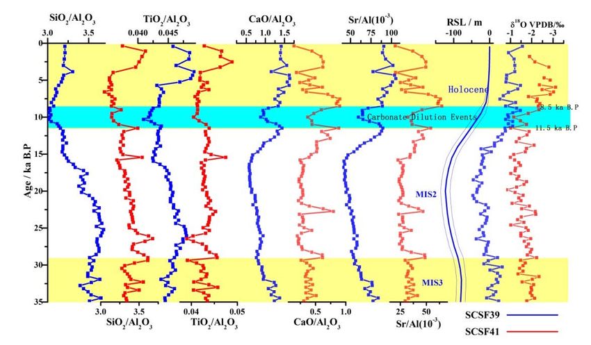
2.13 Vertical Distribution and Size Structure of Zooplankton in Different Water Column
     in the Northern South China Sea (Kaixuan Chen, Meng Zhou, Joanna J. Waniek,
     Yisen Zhong and Yiwu Zhu)                                                            35

3     Investigations of pollutants dispersal in the Bohai and Yellow Sea                  38
3.1   Numerical simulation of pollution’s transportation on the East Chinese Shelf and
      in the northern South China Sea (Wenguo Li, Bernhard Mayer and Thomas
      Pohlmann)                                                                           38
3.2   The budget of nitrate isotopes in Bohai Sea based on an isotopic balance model
      (Shichao Tian, Birgit Gaye, Jianhui Tang, Yongming Luo, Tina Sanders, Kirstin
      Dähnke and Kay-Christian Emeis)                                                     40
3.3   Environmental occurrence and distribution of selected current-used pesticides in
      the Chinese Bohai Sea and surrounding Rivers (Célia P.M. Bento, Tanja Naumann,
      Andreas Wittmann, Jianhui Tang, Xiaomei Zhen and Ralf Ebinghaus)                    42
3.4   Halogenated flame retardants in the sediments of the Chinese Yellow Sea and East
      China Sea (Yanan Li and Jianhui Tang)                                            43
3.5   Legacy and novel halogenated flame retardants in seawater and atmosphere of the
      Bohai Sea, China (Lin Liu, Xiaomei Zhen, Xinming Wang, Yanfang Li, Xu Sun and
      Jianhui Tang)                                                                   44
3.6   Identification of elements distribution patterns in the delta-estuary region by a
      combined magnetic and isotopic approach (Yuan Li and Yongming Luo)                  45

4     Comparison of the European and Asian marginal seas                                  48
4.1   Occurrence and risk of organic UV absorbers in marine sediments of Europe and
      China (Andreas Wittmann, Christina Apel, Jianhui Tang and Ralf Ebinghaus)           48
4.2   Emerging and novel per- and polyfluoroalkyl substances in Chinese and German
      river water impacted by point sources (Hanna Joerss, Jianhui Tang, Thekla-Regine
      Schramm, Linting Sun, Chao Guo, Frank Menger, Lutz Ahrens and Ralf Ebinghaus)       49
4.3   Spatial distribution of microplastics: comparison between the Bohai and Baltic
      seas (Qian Zhou, Chuancheng Fu, Jie Yang, Kuanxu Xiong, Yuan Li, Chen Tu,
      Lianzhen Li, Yongming Luo and Joanna J. Waniek)                                     51
4.4   Characterization of biofilms formed on the surface of diverse types of
      microplastics in the seawater of the Baltic Sea (Chen Tu, Qian Zhou, Ying Liu,
      Xinning Zhang, Joanna J. Waniek and Yongming Luo)                                   52

5     Conclusions and outlook                                                             54
Acknowledgements                                                                          54
References                                                                                55
7

Kurzfassung
Das deutsch-chinesische Verbundvorhaben Megacity’s fingerprint in Chinese marginal seas:
Investigation of pollutant fingerprints and dispersal (MEGAPOL) geht nach drei Jahren
intensiver Zusammenarbeit (01.08.2017-31.07.2020; verlängert bis 31.12.2020) zu Ende.
MEGAPOL hatte zwei regionale Schwerpunkte. Der eine konzentrierte sich auf den
Mündungsbereich des Perlflusses im Südchinesischen Meer und der andere auf das Gelbe
Meer mit dem Yangtse Fluss sowie auf die Bohai See mit dem Gelben Fluss. Die
Verbundpartner auf deutscher Seite sind das Leibniz-Institut für Ostseeforschung
Warnemünde, das Institut für Geologie und das Institut für Meereskunde der Universität
Hamburg, sowie das Institut für Küstenforschung des Helmholtz Zentrums Geesthacht. Auf
chinesischer Seite sind die Verbundpartner der Guangzhou Marine Geological Survey, die
School of Oceanography der Shanghai Jiao Tong Universität, das Second Institute of
Oceanography SOA, Hangzhou, das National Marine Environmental Monitoring Centre, SOA,
Dalian und das Yantai Institute of Coastal Zone Research, CAS, Yantai. Die Prozessstudien
wurden von Deutschland durch das BMBF (03F0786A/B/C) im Rahmen der Wissenschaftlich-
Technischen Zusammenarbeit (WTZ) mit China finanziert sowie von China durch die State
Ocean Organisation (SOA).

Der Verbund hatte zum Ziel, die Umweltveränderungen in den genannten Schelfregionen und
den Randmeeren zu untersuchen und damit die Folgen der Entstehung von Megastädten für
das marine Ökosystem abzuschätzen. Die Untersuchungsgebiete stellen ideale
Modellsysteme dar, um Austauschprozesse zwischen Land und Ozean, Veränderungen der
physikalischen Antriebe (Monsun, Zirkulation), anthropogene Stoffflüsse (u.a. Mikroplastik,
Schadstoffe) und somit die Effekte von Ballungszentren auf die Wechselwirkung Land-Küste-
Ozean sowie die Auswirkungen von klimatischen Änderungen in sensiblen marinen
Ökosystemen besser zu verstehen. Die Probennahme im Südchinesischen Meer wurde auf
drei mehrwöchigen Expeditionen mit chinesischen Forschungsschiffen (HAI YANG DI ZHI SHI
HAO 2015, HAI YANG DI ZHI SHI HAO 2018) und dem deutschen Forschungsschiff SONNE
(2019) durchgeführt. Die Beprobung in der Bohai See und im Gelben Meer fand im April und
August 2018 mit dem chinesischen Forschungsschiff R/V DONG FANG HONG 2 statt.
Flussproben wurden im Mai und Juli bis November im Gelben Fluss genommen sowie im
November aus dem Daliao, Hai, Luan und Xiaoqing Fluss. Für beide regionalen Schwerpunkte
lieferten die physikalischen, bio-geochemischen und ökosystemaren Modellierungen
zusätzliche Erkenntnisse zum Einfluss von wechselnden Umweltparametern auf die marinen
Stoffkreisläufe (N, P, C) und ermöglichten Aussagen zu der zeitlichen und räumlichen
Variabilität der ozeanischen Prozesse.

Der MEGAPOL Verbund wurde durch die Aktivitäten des BMBF Verbundes Südchinesisches
Meer-Natürliches Laboratorium unter klimatischen und anthropogenen Stress (FKZ
03G0269A-B, SOCLIS) erweitert, in dessen Rahmen die Expedition mit dem deutschen
Forschungsschiff SONNE (SO269) im August 2019 im Untersuchungsgebiet am nördlichen
Schelfrand des Südchinesischen Meeres im Mündungsbereich des Perlflusses stattfand. Auf
der Expedition wurde u.a. eine Verankerung für einen Zeitraum von 2 Jahren am nördlichen
8

Kontinentalhang des Südchinesischen Meeres ausgesetzt, wodurch die wissenschaftlichen
Fragestellungen und die Infrastruktur von MEGAPOL erweitert wurden. Diese Arbeiten wurden
durch das TRAN Projekt (Zeitliche Muster anthropogener und natürlicher Partikel am
Kontinentalhang des Südchinesischen Meeres, FKZ 01DO17038) auf der deutschen Seite
finanziert.

In diesem Bericht fassen wir die ersten Ergebnisse der Untersuchungen in Form erweiterter
Kurzbeschreibungen deutscher und chinesischer KollegInnen zusammen, die in einer Online-
Konferenz am 28. und 29. Oktober 2020 vorgestellt wurden.
9

Summary
The bilateral Sino-German joint project Megacity's fingerprint in Chinese marginal seas:
Investigation of pollutant fingerprints and dispersal (MEGAPOL) comes to an end after three
years of intensive cooperation (01.08.2017-31.07.2020; extended until 31.12.2020).
MEGAPOL had two regional focuses, one at the mouth of the Pearl River in the South China
Sea and one on the Yellow Sea with the Yangtse River and on the Bohai Sea with the Yellow
River.

The Leibniz Institute for Baltic Sea Research Warnemünde, the Institute of Geology and the
Institute of Oceanography of the University of Hamburg, the Institute for Coastal Research of
the Helmholtz Centre Geesthacht from Germany and the Guangzhou Marine Geological
Survey, the School of Oceanography of the Shanghai Jiao Tong University, the Second Institute
of Oceanography SOA, Hangzhou, the National Marine Environmental Monitoring Centre, SOA,
Dalian and the Yantai Institute of Coastal Zone Research, CAS, Yantai from China cooperated
in this network. The process studies were financed on the German side by the BMBF
(03F0786A/B/C) within the framework of the WTZ China Initiative, whereas the State Oceanic
Administration (SOA) financed the studies on the Chinese side.

The aim of the network was to investigate environmental changes in the aforementioned
marginal seas and their shelf areas in order to understand the effects of anthropogenic and
natural changes, as a consequence of the formation and development of megacities, on the
marine ecosystem. The study areas represented an ideal model system to better understand
land-ocean exchange processes, changes in physical drives (monsoon, circulation),
anthropogenic matter fluxes (including microplastics, pollutants), the effects of urban
agglomerations on the land-coast-ocean interaction, and the effects of climatic changes in a
very sensitive marine ecosystem. Sampling was carried out on three expeditions lasting
several weeks on Chinese research vessels (HAI YANG DI ZHI SHI HAO 2015, HAI YANG DI ZHI
SHI HAO 2018) and the German research vessel SONNE (2019) in the South China Sea.
Sampling in the Bohai and Yellow Sea was carried out in April and August 2018 by the research
vessel R/V DONG FANG HONG 2. River samples were taken in May, July to November from the
Yellow River, and in November from Daliao River, Hai River, Luan River and Xiaoqing River. For
both regional foci, physical, bio-geochemical and ecosystem modelling provided additional
insights into the influence of varying environmental parameters on changes in
biogeochemical cycles of elements (N, P, C) and allowed the assessment of the temporal and
spatial variability of oceanic processes.

The MEGAPOL consortium was expanded by the activities of the BMBF project South China
Sea Natural Laboratory under Climatic and Anthropogenic Stress (FKZ 03G0269A-B, SOCLIS).
The central activity in SOCLIS was the expedition with the German research vessel SONNE
(SO269) in August 2019 in the working area at the northern shelf edge of the South China Sea
in the research area of the Pearl River. During the expedition, among other things, a mooring
was deployed for a period of 2 years on the northern continental slope of the South China Sea,
thus expanding the scientific questions and infrastructure of MEGAPOL. This work was
10

financed by the TRAN project (Temporal Patterns of Anthropogenic and Natural Particles on
the Continental Slope of the South China Sea, FKZ 01DO17038) on the German side.

In this report we summarize the first results of the investigations in the form of extended short
descriptions presented by German and Chinese colleagues, which were presented in an
online conference on 28 and 29 October 2020.
11

1    Preface
Worldwide, shelf areas are the most productive regions in the world ocean but represent only
7% of the ocean surface and less than 0.5% of the ocean volume. Their proximity to the land
masses makes them particularly important for understanding the exchange processes
between coastal regions and the open ocean, in terms of energy and mass transfer, control of
anthropogenic and terrestrial fluxes, transport, distribution and deposition of pollutants, and
primary production. Shelf seas react rapidly to environmental changes on different time and
space scales as their carbon turnover rates are only a few days to weeks. The amount of
organic material reaching the seafloor and being buried in sediments is higher in shelf areas
compared to the open ocean. Shelf seas are, therefore hotspots of chemical degradation
processes as well as redox reactions in the sediments (e.g. denitrification, reduction of trace
metals) strongly impacting the C, N, P and Fe cycles. In this context, the pollutants introduced
are of importance, which have an adverse effect on the ecosystem. The consequences of
climate change on the one hand and anthropogenic influences on the other hand are only
fragmentarily known in the coastal ocean. In the recent past, large metropolitan areas have
emerged along the coasts (SEITZINGER et al. 2012, UNESCO 2016), which have drawn on the
resources of the hinterland and catchment areas and are exerting steadily increasing pressure
on the coastal environment due to the industrialization of the regions. In 1970 the United
Nations identified three megacities, the number rose to 10 by 1990 and 28 in 2014, with
prediction of 40 megacities world wide by 2030. Many of those being located in the worlds
least developed or threshold countries.

The development of coastal megacities on the Asian continent, especially in China with a
simultaneous industrialization of the hinterland, is omnipresent (UNESCO 2016). However,
the consequences for the marginal seas of these anthropogenic interventions are only
rudimentarily understood and studied, especially with regard to eutrophication and
modern/emerging pollutants (microplastics, hormones, drugs).

Fig. 1: Structure and regional foci of the Sino-German MEGAPOL Project.

The great social and economic relevance of the coastal regions and the marginal seas
worldwide were the scientific rationale for the Sino-German project MEGAPOL (Fig. 1), which
aimed to answer the following questions:
12

• Are the different climatic conditions, geology of the catchment areas, agricultural and
industrial use of the land reflected in regionally specific distributions of substances
introduced and deposited in China's marginal seas (South China Sea vs. Bohai Sea and Yellow
Sea)?
• To what extent is the "fingerprint" of the megacities in marginal seas mapped and/or
modified by the prevailing hydrographic conditions: open shelf and circulation in the South
China Sea versus restricted exchange and circulation in the Bohai Sea and the Yellow Sea?
• What is the function of the sediments in these regions with respect to anthropogenic
pressure, in particular the introduced modern pollutants (e.g. microplastics, UV filters, drug
residues)?

The Bohai Sea and the Yellow Sea as well as the East China Sea in the south are shallow
marginal seas of the Northwest Pacific. They lie almost entirely on the north-eastern Asian
shelf. While the Yellow Sea and the East China Sea are characterized by a strong exchange
with the Pacific Ocean due to their open seaward boundary, the Bohai Sea is a relatively
closed sea, which has only a limited exchange with the open ocean via the 100 km wide Bohai
Strait. Ocean currents throughout the region are dominated by the alternation of summer and
winter monsoons throughout the region. The effect of these seasonal changes including
strong seasonal variations of water and nutrient supply are augmented by the shallow water
depth of less than 50 m in large parts of these marginal seas leading to significant ecosystem
changes. During the last decades, river discharges have decreased significantly, resulting in
increased salinity and decreased phosphate and silicate inputs. At the same time, the input
of reactive nitrogen from wastewater and fertilizers has increased tenfold (NING et al. 2010,
ZHANG et al. 2004, ZHAO et al. 2002). Strong eutrophication, particularly in the area of the river
plumes of the Yellow River and the Yangtze, is the consequence, which seasonally leads to
the formation of so-called oxygen-free death zones (CHEN et al. 2014). Nutrient inputs will
further increase with the planned Bohai Rim Urban Agglomeration/ Northern Yellow Sea and
thus further promote eutrophication and oxygen depletion. The South China Sea (SCS) is the
largest marginal sea of the Pacific Ocean with a well-developed shelf in the north. The
northern shelf of the South China Sea, its transitional region to the continental slope, and the
deep SCS are highly dynamic regions influenced by seasonally and inter-annually varying
forces; their effects are modified and amplified by climatic changes caused by both, natural
and anthropogenic processes. The SCS itself is oligotrophic, whereas the northern shelf is
eutrophic and occasionally suffers from anoxia due to the decay of biomass from locally
enhanced productivity.

The selected marginal seas offer a unique opportunity to investigate the impact of climatic
and anthropogenic pressures on the marine ecosystem, as their distinct shelf areas play a key
function in the land-ocean interaction. According to the 2007 IPCC report, Southeast Asia and
the South China Sea will also experience a temperature increase of up to 6 °C by 2100. This
temperature rise will be accompanied by increased precipitation and extreme weather
conditions, with obvious consequences for the land, the people living there and the marine
ecosystems.
13

During our MEGAPOL online general assembly on 28 and 29 October 2020 a number of studies
were presented grouped into different topics. The sessions on day one were dedicated to the
South China Sea and covered physical oceanography, marine chemistry, marine geology and
biological oceanography. ZHONG et al. presented their work on Kuroshio Current intrusions,
whereas CHENG et al. looked at mesoscale eddies in the region. The typhoon Mangkhut which
also affected one of our cruises was simulated by HU and ZHONG, and its impact on the
environmental conditions was presented by GAO et al. Holocene sediments, sediment
evolution over 30 ka and accumulation of recalcitrant organic matter were presented by
SCHÖNKE et al., LI et al. and CHEN and WANG, respectively. In the following talks pollutions
aspects (FISCH et al., DEICH et al.), nitrogen cycle (MEIER et al.), oxygen deficiency (TANG et al.),
benthic foraminifera as bioindicators of environmental change (PETERSEN et al.) and research
on the trophic structure of the South China Sea (CHEN et al.) were presented.

The focus on the second day was on the East China Sea and the Yellow Sea, modelling efforts
as well as a comparison of specific ecosystems to the Baltic Sea. First, the modelling results
were presented by LI et al. for the East Chinese Shelf and the South China Sea, followed by
the nitrate budget of the Bohai Sea (TIAN et al.). The next group of presentations dealt with
different groups of pollutants, e.g. glyphosate and AMPA (BENTO et al.), Neonicotinoids and
their metabolites (NAUMANN et al.), halogenated flame retardants (LI et al.), their legacy and
new species (LIU et al.). LI et al. used a combination of the magnetic and the isotopic
approaches to understand the distribution of elements in a delta-estuary system. In the next
talk UV absorbers (per- and polyfluoroalkyl substances) found in sediments were studied
(WITTMANN et al.). The session closed with two talks about microplastics distribution patterns
(ZHOU et al.) and biofilm formation (TU et al.).

Joanna J. Waniek1, Detlef E. Schulz-Bull1, Birgit Gaye2, Ralf Ebinghaus3, Friederike Kunz1,
Thomas Pohlmann4, Kay-Christian Emeis2,3
14

2     Physical forcing and the pattern of emerging pollutants in South China Sea
In this chapter the South China Sea, especially the northern shelf and the Pearl River, is in
focus as it provides a unique opportunity to understand the impact of climatic and
anthropogenic pressures on the marine ecosystem. Its distinct shelf areas are a key feature
in the land-ocean interaction. According to the 2007 IPCC report, Southeast Asia and the
South China Sea will also experience a temperature increase of up to 6°C by 2100. This
temperature increase will be accompanied by increased precipitation and extreme weather
(e.g. typhoons), with obvious consequences for the land, the people living there, and the
marine ecosystems. One part of the investigations in the MEGAPOL project has therefore the
regional focus on the northern shelf of the South China Sea and thematically on the study of
the distribution patterns of selected anthropogenic pollutants. It is aiming at identifying their
sources and sinks, determining turnover rates, and describing the "fate" of the investigated
pollutants. Of particular interest to us are emerging pollutants (microplastics,
pharmaceuticals, UV filters), heavy metals, and eutrophication, all closely linked to
anthropogenic pressures, which we examine in light of the physical driving forces (e.g.,
monsoon), processes (transport, dispersion) and events like typhoons.

2.1 Surface Kuroshio Intrusion into the South China Sea derived from Satellite Geostrophic
      Streamlines (Yisen Zhong7, Meng Zhou7, Joanna J. Waniek1, Lei Zhou7 and Zhaoru
      Zhang7)

The Kuroshio intrusion into the Luzon Strait plays a very important role in the mass and heat
exchange between Pacific Ocean and South China Sea (SCS). Due to the paucity of
observational data, there still exists a debate on describing the characteristics of intrusion
and interpreting its mechanism at various time scales. In this study, using geostrophic
streamlines derived from 1993–2018 daily satellite altimeter data, we propose a new method
to recognize the flow pattern of Kuroshio intrusion into South China Sea by tracking the
extension of each streamline originated from Kuroshio. The streamlines are categorized into
three traditional types: leaping across the strait, loop current and direct intrusion into SCS.
The flow pattern can be any combination of these three kinds. This streamline-based method
represents a more elaborate classification and therefore provides new insights into the
Kuroshio intrusion mechanism at different time scales.

Table 1: The occurrence frequency of each possible combination of streamlines over the entire period,
in December and June. Note the sum of each column may be not equal to 1 due to a small number of
unclassified streamlines.

     Streamline type          Frequency         Frequency in Dec          Frequency in Jun
     Leap                     48.2%             9.7%                      89.5%
     Leap+Loop                17.4%             18.2%                     6.8%
     Leap+Intrude             9.8%              24.4%                     0%
     Leap+Loop+Intrude        22.9%             47.6%                     1.3%
15
Fig. 2: Interannual Pacific Decadal Oscillation index (blue) and percentage of intrusion streamlines
(red). Both of them are normalized. The correlation coefficient between them is 0.7.
The streamline analysis shows that the Kuroshio consists of all the three kinds of streamlines
over 22% days of this period (Table 1). The intrusion streamlines account for 20% of the total
in winter but almost all the streamlines leap across the strait in summer. Most of the intrusion
streamlines enter the Luzon Strait via the deep channel south of Babuyan Island, while the
leaping streamlines go into the strait mainly through Balintang Channel and subsequently out
of the strait through Bashi Channel. At the seasonal scale the intrusion streamlines are mostly
located in the left part of the Kuroshio with cyclonic velocity shear, which means the seasonal
variation of the intrusion is merely the seasonality of these streamlines. On an interannual
time scale, the percentage of intrusion streamlines show a strong correlation with ENSO and
PDO indices. The correlation coefficient is over 0.7, much higher than that in previous studies
(usually lower than 0.6), suggesting this new method can better capture the interannual
variation of Kuroshio intrusion (Fig. 2). Nearly all the intrusion streamlines fail to track back
upstream to the North Equatorial Current (NEC), since they are located too close to the coast
where the accuracy of satellite data may be very poor. However, the analysis of leaping
streamlines reveals that the NEC bifurcation latitude has a larger variation than that in
preceding numerical studies. During El Nino years, the bifurcation latitude reaches the
northmost around 15°N, and both the width of Kuroshio Current and the Kuroshio transport
increase. The bifurcation latitude stays south of 14°N with decreased current width and
transport during La Nina years.
Acknowledgements:
This research is supported by the National Natural Science Funding of China
(Grant #: 41706014) and Sino-German cooperation in ocean and polar research – Megacity's
fingerprint in Chinese marginal seas: Pollutant fingerprints and dispersal transformation.
2.2 Statistical characteristics of mesoscale eddies on the continental slope in the northern
South China Sea (Meng Zhou7, Zi Cheng7, Yisen Zhong7 and Zhaoru Zhang7)
The South China Sea (SCS) is considered as oligotrophic where productivity is limited by
dissolved iron and other macronutrients. However, there is an active mesopelagic ecosystem
with high biomass of 30 g m-2 in the SCS. Studies found that even though the biomass of16 primary producers is very lower, the primary production is high approximately 300 mg C m-2 d-1. For understanding mechanisms to support the primary production and food demand of mesopelagic fish, the role of mesoscale eddies in cross-slope transport of nutrients and biomass in the northern continental slope region are studied based on satellite altimetry data from 1993 to 2016. The results reveal that a total of 147 eddies including 70 cyclonic eddies (CEs) and 77 anticyclonic eddies (ACEs) are detected in the continental slope region (CSR). The eddies are mainly originated from two areas: near the Dongsha Islands (DS) and southwest of Taiwan (SWT), which contribute more than 60% of the total (Fig. 3a, b). Fig. 3: Seasonal distributions of the number of eddies that are generated in the DS (a) and in the SWT (b) and subsequently enter the CSR. According to the spatial distribution of eddy relative vorticity, both cyclonic and anticyclonic eddies generally weaken as they propagate westward roughly along the slope isobaths. During the life span of eddies, the ACEs move slightly faster along the isobaths, while the CEs tend to cross the isobaths into the shallow water or deep basin (Fig. 4a–d). After leaving the
17

CSR, the ACEs generally move further into the basin areas, and the CEs still linger around the
CSR. The eddy propagation on the continental slope is found to be linked with the mean flow
field to some degree since the eddy trajectories have noticeable seasonal cycles in agreement
with the seasonality of geostrophic current, which indicates that the eddy propagation
velocity is largely determined by the along-slope geostrophic current in both magnitude and
direction.

Fig. 4: Mean eddy propagation velocities in the CSR. a and b are eddy velocity fields of CEs and ACEs,
respectively; c and d are compass diagrams of CE and ACE propagation velocities, respectively.

Acknowledgements:
This research is supported by the National 973 Program on Key Basic Research (Grant #
2014CB441500), the National Natural Science Funding of China (Grant #: 41706014) and Sino-
German cooperation in ocean and polar research - Megacity's fingerprint in Chinese marginal
seas: Pollutant fingerprints and dispersal transformation.

2.3 Numerical simulation of Mangkhut typhoon waves in South China Sea (Mengxi Hu12 and
     Yisen Zhong7)

The tropical cyclones as the most extreme meteorological events can generate complex and
disastrous ocean waves propagating towards the shorelines, which may cause vast economic
losses and human causalities in the South China Sea. It is thus of great importance and
interest both practically and scientifically to model the typhoon waves and help understand
their physical properties (Komen et al. 1994, Xu et al. 2017, Young 2006).
18 A third-generation wave model is driven by the synthetic wind field combined with the Holland wind and the surface wind product from National Centers for Environmental Prediction (NCEP), in order to numerically simulate the TWs generated by the 22nd typhoon "Mangkhut" in 2018. The modelled results are in good agreement with the buoy-based observations (Fig. 5a–f). Therefore, the model can well simulate the typhoon waves under "Mangkhut" in South China sea. The temporal and spatial characteristics of the wind-sea and swells during the typhoon were studied. The results show that the far field is dominated by swells radiating from intense wind region, and the maximum significant wave height is always located on the front-right side of the typhoon moving direction where wind-sea dominates (Fig. 6). This indicated that the typhoon waves have obvious asymmetry. Except for the left rear quadrant of the typhoon's forward direction, the corresponding dominated waves gradually change from wind-seas to swells as the distance from the typhoon center increases. Fig. 5: Comparison of simulated and measured (a, b) significant wave height, (c, d) mean wave period, (e, f) mean wave direction. The left and right columns correspond to two different stations.
19

Fig. 6: The spatial distribution of the dimension free peak frequency v. According to the fetch-limited
theory, locations are dominated by wind-sea when v>0.13, and vice versa, it is swell-controlled. The
data is projected onto a frame with the typhoon's forward direction as 0°, and the typhoon center is the
origin. The solid arrow indicates the relative wave direction, and the dashed arrow is the relative wind
direction. The distance of the coordinate axis is based on the maximum wind speed radius.

Acknowledgements:
This work was funded by Project of China Geological Survey (CGS) (No. DD20190218) and
Leibniz Institute for Baltic Sea Research Warnemünde. We thank the crews in Hai Yang Di Zhi
ship for their great effort in wave buoys deployments on the No.201809 cruise.

2.4 Ecosystem production response to typhoon in the oligotrophic South China Sea (Yonghui
     Gao7, Ji Li7, Yisen Zhong7, Meng Zhou7 and Joanna J. Waniek1)

Marine biological carbon fixation via phytoplankton photosynthesis converts atmospheric
CO 2 to particle organic carbon (POC), which becomes major source of carbon export flux to
the deep ocean. Although continental shelf only accounts for 7% of the world ocean area, they
contribute near 1/3 of the oceanic CO 2 intake from atmosphere (MULLER-KARGER, 2005). As
the largest continental shelf in Asia and Pacific Ocean, South China Sea (SCS) has drawn
much attention in biological carbon intake.

Net community production (NCP), the deduction of ecosystem respiration from the biological
carbon uptake, is valuable because it can accurately estimate the carbon sequestration in the
ocean. Dissolved oxygen (DO)/argon (O 2 /Ar) ratios in the oceanic mixed layer are indicative
of net community production (NCP) because O 2 and Ar share similar physical solubility
properties, but only O 2 is biologically produced or consumed (CASSAR et al. 2009). In this
20 study, we use the continuous O 2 /Ar method to map the net community production thoroughly in the continental shelf of SCS before and after a typhoon (Fig. 7). Fig. 7: Bi-typhoons, Barjat (blue line, Sept. 12-14) and Mangkhut (red line, Sept. 16-18), passed through the central research region twice. Dark and green dots indicate the CTD sampling stations before and after typhoon. Fig. 8: Spacial distribution of sea surface temperatue (℃, A), Salinity (B), DO% (C) and Net community production (mmol C m-2 d-1, D) before typhones.
21

Before typhoon (Sept. 2–14, 2018), sea surface temperature changed consistently with
salinity (Fig. 8), and both increased from nearshore to offshore region (Fig. 8A, B). NCP and
DO% in most of water, especially in the offshore region, were slightly under-saturated (Fig.
8C, D). Summer monsoon, driven by the north-east wind, directly affect the surface
circulation, thus SCS exhibit distinguished monsoon-driven pattern in the primary
productivity and nutrient dynamics. DO% were positive and NCP were up to 33 mmol C m-2 d-1
in which upwelling and the Pear River plume might deliver nutrients and alleviate the nutrient
limitation (Fig. 8C, D).

Fig. 9: Net community production (NCP) changes in response to typhoon. The line in the bars is the
median value; the bottom and top edges of the box indicate the 25th and 75th percentiles; the lower
and upper extent of the bars are the 10th and 90 percentiles; the dots are outliers.

Moreover, tropical cyclones (i.e., typhoons) occur frequently in summer. During our
investigation (Sept. 1–30, 2018), typhoon Barjat and Mankhut passed through the central
region in Sept. 11 and Sept. 16, respectively (Fig. 7). Typhoon-induced cooling, along with
vertical mixing, entrainment, and upwelling, lead to transport of nutrient-rich deep water to
the nutrient-depleted surface, thereby stimulated phytoplankton growth and induced an
increase in NCP. Although autotrophic center changed due to strong mixing and dilution,
ecosytem turned to autotrophic in most of the overlapped region before and after typhoon
(Fig. 9). The overall contribution of typhoons to the NCP is around 30% in the overlapped study
region in SCS. This study provide first underway estimation in production and would help to
gain better understanding of the initiation of phytoplankton blooms in later summer and their
impacts on the local biological carbon uptake.
22

2.5 Holocene paleoenvironmental reconstruction of the inner South China Sea shelf near the
    Pearl River Delta based on geochemical and hydroacoustic investigations (Mischa
     Schönke1, Olaf Dellwig1, Jérôme Kaiser1, Pingyuan Li12 and Helge W. Arz1)

Marginal Seas are highly productive and dynamic systems playing an important role for
biogeochemical and pollutant exchange processes between the land and the ocean. The
South China Sea (SCS) is one of the largest semi enclosed basins in the western Pacific Ocean
and comprises both a broad shallow shelf in the northern part and a large NE–SW oriented
abyssal basin in the center part. In the SCS, the Pearl River Delta (PRD) is one of the key
regions to investigate the land-ocean interaction and has been studied extensively since the
1980s (TANG et al. 2010). The complex natural conditions of the PRD, including seasonal
changes in longitudinal currents and high river runoff (LÜDMANN et al. 2001), in combination
with the rapid and extreme high urbanization (Fig. 10) makes it a challenging task to study
how natural and anthropogenically induced stress act on the marine environment. While most
studies focus on the Quaternary deposits in the PRD (TANG et al. 2010, LIU et al. 2014), only
few papers deal with the Holocene sedimentary conditions (TANG et al. 2010, LÜDMANN et al.
2001, WEI & WU, 2011).

However, a good understanding of recent sedimentation patterns and geochemical
conditions is an essential step to differentiate and understand natural and anthropogenic.
Influences on the SCS. Based on high frequency hydroacoustic profiles (Parasound P70),
recorded perpendicular to the coastline with an average spacing of 50 km and a length of
400 km. In addition, a transect of short sediment cores was carried out from the estuary to
the deeper sea basin, to investigate the impact of the Pearl river plume on the SCS.

Seismic and hydroacoustic surveys during the cruise could be used to identify suitable coring
locations comprising fine-grained deposits at the Pearl river mouth. Short and long sediment
cores obtained along the acoustic profiles verified that no further surface layer with muddy
sediments was present. Bearing in mind the relative low area coverage by the acoustic
investigation and the signal interference due to strong regional gas contents, the current
results support the findings of previous studies arguing against substantial deposition of fine
sediments on the shelf.

However, preliminary age models and core logging data of two gravity cores from 38 m and
62 m water depth suggest very high detrital sedimentation to be associated with the early
Holocene eustatic sea-level rise transgressing the inner shelf area around 11 ka BP (SO269-
98-3). High sedimentation rates are maintained throughout the Holocene at the or close to
the depocenter of the offshore “mud belt” (SO269-135-3). Compositional changes further
reveal a close connection to the orbital paced Holocene SW monsoon dynamics and the inner
shelf current regime. Multi-proxy paleoenvironmental reconstructions including biomarkers
and inorganic geochemistry on these paired sediment cores are ongoing.
23 A crustal-like distribution of heavy metals in the surface sediments of the shallower parts of the SCS suggest a limited contribution by Pearl River-derived material at present. In addition to a potentially current-related near-coastal deposition, suspended particulate matter from the Pearl River (H10 cruise) indicates substantial storage of heavy metals such as Cd, Cu, Ni, Pb, and Zn just within the low salinity realm (1500 m) are significantly enriched in several metals such as Bi, Cd, Cu, Ni, Sb or Tl compared to the geogenic background. However, a parallel enrichment in redox-sensitive Mo argues against an anthropogenic impact and highlights a natural process related to scavenging by Mn oxides forming at the sediment-water interface as indicated by solid phase Mn and corresponding pore water profiles. Fig. 10: Map of the research area, highlighting the recorded acoustic transects (yellow lines) and selected working stations (MUC and GC) for detailed analysis. The selected sampling transect is located in the PRE region (OU et al. 2007), reaching form the river mouth to the deep-sea basin.
24

2.6 Sedimentary environmental evolution for the past 30 ka on the northern continental
     slope of the South China Sea (Pingyuan Li12, Jianfei Lu12, Zhen Xia12 and Huayang Gan12)

The South China Sea is the largest marginal sea in the Western Pacific. The surrounding land
provides massive sediments. Lots of sediments are transported into the deep sea basin
through a complex ocean current system through the land slope, and thus the continental
slope becomes an important region in the study of deep-sea sediment source and sink
system. However, the water depth in the continental slope area varies greatly, the current
system in the area is complicated, and the sea level also changes strongly during the glacial-
interglacial periods, making the continental slope sedimentary environment study as a hard
point.

Fig. 11: Topographic map of the studied region.

In order to study the sedimentary environmental evolution on the continental slope, we
selected two gravity cores in the continental slope of the Northern South China Sea, one
locates at middle of slope, and the other locates at the bottom of the slope (Fig. 11). Through
a series of geochemistry analysis, grain size analysis, and dating analysis and previous
25 studies (ZHAO et al. 2018, WAN & ZHIMIN 2014), the results demonstrate: 1) sea level changes are the dominate factor controlling the changes of terrigenous / biogenous components on the continental slope. The shallow slope region is more sensitive to the sea level changes than the bottom slope region; 2) a carbonate dilution event is found related to the intensification of the East Asia Summer Monsoon during the early Holocene from 11.5 to 8.5 ka B.P (Fig. 12, Fig. 13). Fig. 12: Geochemical characteristics of the core SCSF39 and SCSF41. Fig. 13: Grain size distributions of the core SCSF 39 and SCSF41. Acknowledgements: This study was supported by the Chinese Geological Survey Foundation “A Synthesize Geological Survey Project on the Lingdingyang Area, Pearl River Estuary (DD20190289).”
26

2.7 Accumulation of recalcitrant organic matter in porewaters in sediment cores of the
     northern South China Sea (Yunru Chen8 and Fengping Wang8,7)

During organic matter decomposition in sediments, dissolved organic matter (DOM) is
released into the porewater by hydrolysis and depolymerization of particulate organic matter
(POM) (SCHMIDT et al. 2017). Therefore, the chemical composition of DOC not only determines
the bio-availability of the DOC, but also records the dynamic exchange of organic carbon
between POM and DOM. To study the changes of dissolved organic matter under microbial
mediation in the sediment cores, Fe(II), sulfate, and dissolved organic carbon (DOC)
concentrations in the porewaters were measured, and the optical properties of DOC were
characterized by UV-visible absorbance and 3D Excitation-Emission Matrix (3D-EEM).
Humification index (HIX) is calculated to represent the extent of humification (WEISHAAR et al.
2003). Specific ultraviolet absorbance at 254 nm is calculated to evaluate the aromatic
content (OHNO 2002).

Fig. 14: Fe(II) and sulfate concentration profiles of the sediment cores.

In coastal cores, bio-available Fe(III) was consumed quickly in less than one meter and sulfate
consequently serves as the electron acceptor in anaerobic microbial respiration (Fig. 14). In
contrast, iron reduction can persist for the upper 5 meters in cores from the continental area
and the deep sea, indicating less bio-labile DOC seawards (Fig. 14).

Intriguingly, DOC concentration gradually increased with depth in all sediment cores, showing
2–8 times higher at the bottom than those at the surface. The accumulated DOC was
characterized by high humic-like fluorescence (Fig. 15). Meanwhile, downcore increasing
27
SUVA254 shows more significant contribution of the aromatic fraction (Fig. 15). These
aromatic compounds may result from microbial degradation of DOC, as the production of
aromatic compounds is higher in the coastal area, where stronger microbial activities are
expected. The accumulation of these aromatic molecules in core SO269-1 suggests the
preferential preservation of recalcitrant compounds in the sediments during long-distance
transport.
Fig. 15: Humification index (HIX) and specific ultraviolet absorbance at 254 nm [SUVA254 (L mgC-1 m-1)]
profiles of DOC in the sediment core porewaters.
2.8 The nitrogen cycle in the northern South China Sea: Impact of the Pearl River (Jan Maier2,
Carolin Perkuhn2, Shichao Tian2, Joanna J. Waniek1, Niko Lahajnar2, Kay Emeis2,3 and
Birgit Gaye2)
The South China Sea (SCS) is an oligotrophic marginal sea where fixation of atmospheric
dinitrogen has been estimated to account for up to 20% of total new production (CHEN et al.
2003, GAYE et al. 2009). The enhanced entrainment of reactive nitrogen from the growing
agriculture, land use change, energy consumption, waste and sewage disposal, change
nitrogen sources and sinks and locally stimulate eutrophication, especially in the near shore
areas off the Pearl River mouth.
In aquatic environments, δ15N values of dissolved and particulate nitrogen are used to
decipher the role of nitrogen cycling processes and to identify nitrogen sources. Most
incomplete reactions in the nitrogen cycle are associated with a kinetic fractionation of the
stable isotopes 14N and 15N, leading to enrichment of the lighter 14N in the reaction product and28 of the heavy isotope in the residual substrate pool (CASCIOTTI 2016, SIGMAN et al. 2005, GAYE et al. 2013). Paired nitrogen and oxygen isotope ratios (δ18O) of dissolved reactive inorganic nitrogen additionally allow tracking of natural vs. anthropogenic sources of these nutrients and are therefore useful indicators of anthropogenic stress (KENDALL et al. 2007). δ15N values below 5‰ of nitrate and sediments particularly in the northeastern SCS were related to high rates of nitrogen fixation in the Western Pacific and import of this signal by inflow of intermediate water masses (CHEN et al. 2003, YANG et al. 2017). δ15N values of dissolved reactive nitrogen of 3 to 5‰ within the Pearl River are in a similar range as the values of the marine end member. However, isotope fractionation by nitrogen assimilation leads to enhanced δ15N values up to 9‰ off the river mouth (YE et al. 2015). The aim of this study is to improve the existing concepts of nitrogen transport and nitrogen cycling in the northern SCS and to estimate the impact of the anthropogenic enhancement of aeolian and riverine nitrogen supply. Water and suspended matter (SPM) were sampled during the research cruise SO 269 along a grid off the Pearl River mouth extending to the lower continental slope. δ15N values of dissolved reactive and particulate nitrogen have been investigated and results of stable nitrogen isotope analyses are presented. Fig. 16: Suspended matter concentrations (SPM) in surface waters in the northern SCS off the Pearl River mouth (A) and δ15N [‰] values of suspended particulate nitrogen close to the coast and along two offshore extending transects (B). The river plume is delineated by reduced salinities as well as enhanced nutrient and SPM concentrations in the upper 10 m of the water column (Fig. 16A, B). The riverine nutrients cause enhanced productivity with δ15N values below 5‰ in the surface SPM due to the prevailing fractionation effect (15ɛ) of 3‰. The strong increase of δ15N values at the margins of the river plume are due to the uptake of residual nitrate, which has become isotopically enriched up to δ15N values > 8‰. Outside the area impacted by Pearl River discharge, subsurface waters are the major nutrient source. This is indicated by deep chlorophyll maxima dropping from 40 m depth near shore to 80 m offshore. The δ15N values of SPM 4–7‰ within this chlorophyll maximum reflect those of subsurface nitrate (YANG et al. 2017). Although the
29

riverine and marine end-members have quite similar δ15N values in the study area, the
position of the chlorophyll maximum allows distinguishing these nutrient sources.

Acknowledgements:
We thank the BMBF for funding the sampling campaign in the South China Sea within the joint
Sino-German project MEGAPOL with the subproject SOCLIS-N carried out at the University of
Hamburg (BMBF grant 03G0269B). We further thank the BMBF for funding the PhD position of
Shichao Tian within a complementary study in the Bohai and Yellow seas by the project
FINGNUTS (BMBF grant 03F0786B). We are indebted to officers and crew of RV SONNE for their
help during sampling on board. We are grateful to Markus Ankele, Jenny Jeschek, Lars Kreuzer,
Sigfried Krüger, Frauke Langeberg, Robert Mars, Birgit Sadkowiak, and Ingo Schuffenhauer for
technical support and laboratory analyses.

2.9 Estrogenic compounds in the Pearl River Estuary and coastal South China Sea (Carina
    Deich1, Marion Kanwischer1, Helena C. Frazão1, Jana-Sophie Appelt1, Ruifeng Zhang7,
    Wenguo Li4, Thomas Pohlmann4 and Joanna J. Waniek1)

Densely populated regions such as the area around the Pearl River Estuary are suspected of
exerting considerable anthropogenic pressure on the surrounding environment. It has been
found that modern pollutants can be transported into rivers and thus into the marine
environment via sewage treatment plant effluents as well as through incorrect disposal of
industrial waste (YING et al. 2002, YING et al. 2008). Estrogenic substances have gained
concern as they interact with the hormone system of organisms, where they can cause
adverse health effects. They are therefore categorized as endocrine disrupting compounds
(EDCs). For example, MORTHORST et al. (2014) showed that the natural estrogen estradiol
adversely affects embryos of the viviparous eelpout (MORTHORST et al. 2014).

In this study, we analyzed surface water samples taken along the salinity gradient of the Pearl
River Estuary (PRE) and from the northern South China Sea (SCS; Fig. 17A) for six target
analytes, i.e., estradiol, estrone, ethinylestradiol, daidzein, genistein and zearalenone. The
samples were investigated via instrumental analysis on a liquid chromatography–tandem
mass spectrometry system.

Natural estrone was detectable at all stations in the PRE and at most stations in the SCS (Fig.
17B, Fig. 18). Natural 17β-estradiol was not detected in the PRE, but occurred in the SCS at
stations close to the coast in August 2019. Synthetic ethinylestradiol was only present in the
PRE at the sampling site closest to the South China Sea (Fig. 17B). Comparatively high 17α-
ethinylestradiol concentrations were measured in the SCS during both sampling campaigns
at stations close to the coast. Daidzein, genistein and zearalenone were detected at most
stations in the PRE, but only genistein occurred at one station in the SCS. In general, estrogen
concentrations in the estuary declined towards the sea except for the station close to the
estuary’s mouth (PR-1; Fig. 17B). In the SCS, the surface density and the modeled surface
30 currents indicate an influence of the Pearl River plume on the stations close to the coast. This could explain the observed distribution patterns of estrogens. Also, the distribution patterns show regional and inter-annual variability presumably arising from the prevailing monsoon. Fig. 17: Study sites in the northern South China Sea (A). Concentrations of estrone (E1), 17β-estradiol (E2) and 17α-ethinylestradiol (EE2), daidzein (DAI), genistein (GEN) and zearalenone (ZEN) in the Pearl River Estuary (2018) with surface water temperature and salinity (B). Fig. 18: Risk quotients based on E1, E2 and EE2 in surface water samples from A) the Pearl River Estuary (2018) and from the northern South China Sea in B) 2018 and C) 2019. Risk quotients based on compound specific predicted no-effect concentrations were calculated to estimate the potential risk to which marine organisms could be exposed. The natural steroids estrone and 17β-estradiol concentrations indicate a low to moderate risk to aquatic organisms, while synthetic 17α-ethinylestradiol concentrations indicate a high ecotoxicological risk in freshwater and saltwater (Fig. 18).
31

Acknowledgements:
We would like to thank the participants and the crew of the cruises on Hai Yang Di Zhi Shi Hao
in September 2018 and on board of SONNE-269 in August 2019. This research is part of the
Sino-German project MEGAPOL which received funding from the BMBF under contract
numbers 03F0786A and 03F0786B as well as 03G0269 (SONNE-SOCLIS).

2.10 Distribution patterns of organic pollutants in water and sediment samples of the South
    China Sea (Kathrin Fisch1, Ines Hand1, Maike Wilschnack1 and Detlef E. Schulz-Bull1)

In the Pearl River Estuary (PRE), a megacity is currently emerging, which puts high
anthropogenic pressure on the ecosystem of the estuary and the northern South China Sea
(SCS).

The aim of this study was to analyze the anthropogenic fingerprint of the Pearl River plume on
the northern South China Sea. To reach this goal, we analyzed 15 polycyclic aromatic
hydrocarbons (PAH), 4 dichlorodiphenyltrichloroethane’s (DDT), 24 polychlorinated
biphenyls (PCB), and 40 pharmaceuticals and personal care products (PPCP) in the water and
sediment of the northern SCS. All samples were taken during the cruise with R/V
Hai Yang Di Zhi Shi Hao in September 2018.

PAHs, PCBs, and DDTs belong to the group of persistent organic pollutants (POPs) and have
been monitored in the environment for several decades. Whereas, PPCPs belong to the group
of contaminants of emerging concern and have only been studied in the environment in the
last decade.

Of the 40 analyzed PPCPs, only three pharmaceuticals and two UV-Filters were detected in the
surface water of the northern SCS, and 14 in the Pearl River Estuary at low ng/L concentrations
(parts will be published in (FISCH et al. 2021). In the Pearl River, clear distribution patterns
could be detected for the pharmaceuticals, yet not for the UV-Filters. The pharmaceuticals
either originate from the domestic wastewater or intensive livestock industry. Whereas UV-
Filters possibly originate from diffuse sources. The PPCPs in the northern SCS do not display
a distinguishable distribution pattern. However, their detection can lead to the conclusion
that they could be more stable in the marine environment than expected (FISCH et al. 2021).

Sediment samples were analyzed for PAHs, PCBs, DDTs, and PPCPs (Fig. 19A–D). The general
distribution pattern shows that higher concentrations tend to occur in the eastern part of the
working area. This is the first time that PPCPs were analyzed, in sediments of the SCS. The
PPCP distribution pattern displays elevated concentrations at the edge of the shelf and lower
concentrations on the shelf. The distribution pattern of the PAHs and DDTs is similar to the
previously reported distribution pattern of KAISER et al. (2018) from a cruise in spring 2015
(KAISER et al. 2018).
You can also read