North polar trough formation due to in situ erosion as a source of young ice in mid latitudinal mantles on Mars - Nature
←
→
Page content transcription
If your browser does not render page correctly, please read the page content below
www.nature.com/scientificreports
OPEN North polar trough formation
due to in‑situ erosion as a source
of young ice in mid‑latitudinal
mantles on Mars
J. Alexis P. Rodriguez1*, Kenneth L. Tanaka1, Ali M. Bramson2, Gregory J. Leonard3,
Victor R. Baker3,4 & Mario Zarroca5
The clockwise spiral of troughs marking the Martian north polar plateau forms one of the planet’s
youngest megastructures. One popular hypothesis posits that the spiral pattern resulted as troughs
underwent poleward migration. Here, we show that the troughs are extensively segmented into
enclosed depressions (or cells). Many cell interiors display concentric layers that connect pole- and
equator-facing slopes, demonstrating in-situ trough erosion. The segmentation patterns indicate
a history of gradual trough growth transversely to katabatic wind directions, whereby increases
in trough intersections generated their spiral arrangement. The erosional event recorded in the
truncated strata and trough segmentation may have supplied up to ~25% of the volume of the mid-
latitude icy mantles. Topographically subtle undulations transition into troughs and have distributions
that mimic and extend the troughs’ spiraling pattern, indicating that they probably represent buried
trough sections. The retention of the spiral pattern in surface and subsurface troughs is consistent
with the megastructure’s stabilization before its partial burial. A previously suggested warm
paleoclimatic spike indicates that the erosion could have occurred as recently as ~50 Ka. Hence, if the
removed ice was redeposited to form the mid-latitude mantles, they could provide a valuable source
of near-surface, clean ice for future human exploration.
Planum Boreum (PB), the Martian north polar plateau, consists of a water–ice cap that features a network of
troughs arranged in a clockwise spiral p attern1,2 (Fig. 1A). The history of PB possibly spans as much as ~ 3 billion
years1. Its stratigraphy includes an ancient, basal sequence of poorly preserved layers overlain by local sets of bur-
ied, frozen dunes and the much younger, well-preserved, water–ice-rich north polar layered deposits (NPLD)1.
The NPLD consist of hundreds to thousands of layers formed by episodic ice accumulation due to cyclic
climatic fluctuations with various periodicities on the order of tens and hundreds of thousands to millions of
years3–9. A potential solar cycle of only ~ 1.5 Ka could have also modulated the depositional episodicity7. These
polar materials consist of two distinct u nits1,7: upper and lower layered deposits (ULD and LLD, respectively)
(Fig. S1). The ULD is the youngest, uppermost part of the NPLD. It consists of several high-albedo layers form-
ing a sequence tens-of-meters thick and displays a mean crater age of 8.7 ± 6.2 Ka1,7. This unit covers most of
the plateau’s inter-trough regions and exhibits widespread, topographically subtle (a few tens of meters deep)
linear depressions (undulations, (Fig. S2)10). Unlike the troughs, the undulations have surfaces that lack layered
exposures10. On the other hand, the LLD consist of moderately high-albedo layers locally resolvable down to
decimeter and meter thicknesses; possibly numbering in the hundreds to thousands in the thickest sequences
that reach several hundred meters of r elief1,7,10,11. Superposed over both the ULD and LLD is the youngest unit—a
tens-of-cm-thick residual ice cap and local deposits of dark sedimentary m aterial1,2.
Detailed mapping of the polar plateau’s stratigraphy combined with crater count statistics suggest that the
NPLD could have started to accumulate during the Middle Amazonian (~ 1 Ga)1 and that the trough surfaces
might be at least ~ 3.6 ± 2.5 Ma7. This hypothesis implies that the NPLD-forming ice was stable over enormous
1
Planetary Science Institute, 1700 East Fort Lowell Road, Suite 106, Tucson, AZ 85719‑2395, USA. 2Department of
Earth, Atmospheric, and Planetary Sciences, Purdue University, 550 Stadium Mall Dr, West Lafayette, IN 47907,
USA. 3Department of Planetary Sciences, Lunar and Planetary Laboratory, University of Arizona, Tucson,
AZ 85721, USA. 4Department of Hydrology and Atmospheric Sciences, University of Arizona, Tucson, AZ 85721,
USA. 5External Geodynamics and Hydrogeology Group, Department of Geology, Autonomous University of
Barcelona, 08193 Bellaterra, Barcelona, Spain. *email: alexis@psi.edu
Scientific Reports | (2021) 11:6750 | https://doi.org/10.1038/s41598-021-83329-3 1
Vol.:(0123456789)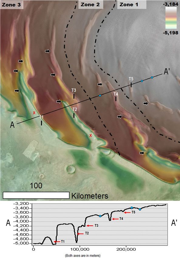
www.nature.com/scientificreports/
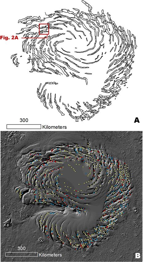
Figure 1. (A) Map of the NPLD troughs, including the outlines of their widespread constituent enclosed
depressions (cells). The location of Fig. 2A is indicated. (B) Map showing a statistically significant population
(950) of local image observations within the NPLD troughs, which demonstrates the presence of widespread
trough interior surfaces produced by in-situ truncation. The observations include cell floor depressions (red
dots) and mounds (blue dots) with concentrically layered exposures (including both equator- and pole-facing
layers) and cells that only have equator-facing surface exposures (yellow dots). The base map is a MOLA shaded
relief, illumination from the upper left (256 pixels/degree, credit: MOLA Science Team, MSS, JPL, NASA). We
produced this figure using Esri’s ArcGIS 10.3 (http://www.esri.com/software/arcgis).
geologic timescales, as appears to be regionally the case for the ice that forms PB’s basal unit1 and its surround-
ing zones of the Vastitas Borealis Formation (VBF), an ice-rich deposit that covers most of the planet’s northern
plains12.
However, there is a standing disagreement between the NPLD ages derived from geologic i nvestigations1,2,7
and those inferred from paleoclimatic s imulations3,5. The latter view suggests NPLD accumulation may have
started ~ 4 Ma when a decrease in Mars’ mean obliquity to ~ 25° destabilized the mid-latitude ice reservoirs,
resulting in climatic conditions that facilitated water vapor transport and widespread deposition to the north
pole3,5. In accordance with this geologic context, an estimate is that the upper few hundred meters in the NPLD,
including the materials exposed within the troughs, could have formed during the last ~ 370 K a13. This is an order
of magnitude younger than the ~ 3.6 ± 2.5 Ma age determined from crater counts7. Thus, NPLD accumulation
times of millions to hundreds of millions of years all seem plausible, and previous models of NPLD accumulation
all make assumptions about processes for which much uncertainty exists.
Surface geologic investigations of Viking Orbiter d ata14,15 and the later analysis of subsurface radar reflectors
obtained by the Shallow Radar (SHARAD) sounder onboard the Mars Reconnaissance O rbiter15–19 suggest the
troughs initiated about halfway through the NPLD accumulation and that they migrated poleward as further
Scientific Reports | (2021) 11:6750 | https://doi.org/10.1038/s41598-021-83329-3 2
Vol:.(1234567890)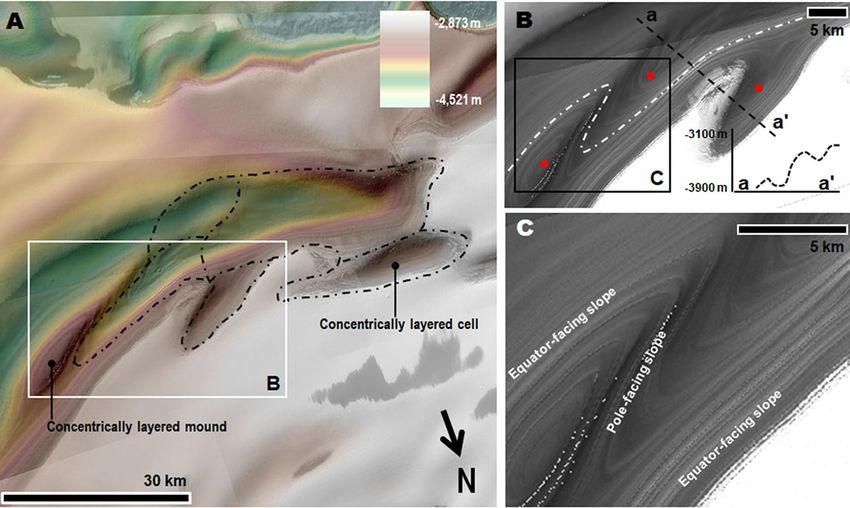
www.nature.com/scientificreports/
accumulation of the NPLD ensued. The hypothesized trough migration is generally explained by water–ice trans-
fer from the troughs’ warmer equatorward-facing slopes to their colder poleward-facing slopes. The processes
involved include solar insolation-driven sublimation of equatorward-facing ice, downslope transport of water
vapor via katabatic winds, ice-vapor condensation onto the cold, poleward-facing slopes, and perhaps mechanical
erosion and sedimentation of ice p articles14,16,17. Simulations of the sublimation from the trough walls, combined
with proposed NPLD accumulation rates recreate the trough-migration paths inferred to exist in the subsurface
from radar-sounding d ata20. The trough migration process has also been invoked to explain the development of
their spiral pattern as poleward migration rearranged systems of initially disorganized t roughs21.
In this article, however, we show geologic evidence indicating that in-situ erosion led to the formation of
the currently exposed troughs and undulations and that their current spiral arrangement resulted from their
progressive growth and spatial integration.
Methods
We used Esri’s ArcGIS software as the primary mapping and analytical tool for the spatial, topographic, and
stratigraphic characterizations of troughs and undulations across the entire north polar plateau, Planum Boreum.
Because this morphologic mapping required high-resolution images registered to an accurate digital elevation
model (DEM), we used (~ 6 m/pixel) Mars Reconnaissance Orbiter Context Camera (CTX) and (~ 18 m/pixel)
Thermal Emission Imaging System (THEMIS) VIS (visible light) image mosaics georeferenced to a Mars Orbiter
Laser Altimeter (MOLA) DEM (~ 115 m/pixel with a one-meter vertical accuracy). We mapped the troughs’
inner segmentation into cells by topographically tracing the upper margins of the interior enclosed depressions
that constitute the cells (Fig. S3). To perform the trough volume calculations, we first defined polygons around
each mapped trough and extracted elevation points along their rims to produce a triangulated irregular network
(TIN), representing interpolated surfaces spanning across the troughs. From this we produced a gridded recon-
structed (i.e., pre-erosional) capping surface across Planum Boreum. Finally, we subtracted the troughs’ current
topography from the modeled capping surface to estimate the approximate erosional volumes consequent of
their excavation.
Results
Evidence of widespread trough interior in‑situ erosion. In plan view, most NPLD troughs have
simple elongate, quasi-elliptical outlines exhibiting topographic segmentation (Fig. S3). Each segment (hereon,
referred to as a cell) consists of an enclosed depression outlined by equator and pole-facing slopes (letters A–E
in Fig. S3), which locally flank trough interior ridges (numbers 1–3 in Fig. S3).
Here, we present the first comprehensive map of the NPLD trough cells (Fig. 1A). Our map reveals extensive
trough segmentation, which until now had not been integrated into an understanding of the troughs’ geologic
history. The cells, which generally have concave elongate shapes, exhibit two types of stratigraphic exposures:
(1) those with layers that are traceable around the complete perimeters of the cell walls, as well as the flanks of
interior positive relief features such as mounds, thus forming concentrically layered patterns (Figs. 1B, 2A–C,
S4–S8) stratigraphically reconstructed in Fig. 3, and (2) those that display layers only on equator-facing slopes
(Figs. 1B, 4, S4, S9).
Our map shows that the concentrically layered outcrops within trough cells are common across the entire
polar plateau (Fig. 1B, red and blue dots). These stratigraphic exposures, showing traceable layer continuity
across cell slopes (Figs. 2B,C, S4–S8), comprise evidence of trough formation and segmentation associated with
widespread in-situ NPLD excavation (Fig. 3). Some scarps expose cross-sectional views of this erosional stratig-
raphy (Figs. S9, S10). Inter-cell ridges of varying lengths and widths, and trough interior mounds, indicate that
erosion within troughs occurred heterogeneously (e.g., Figs. 2, S3, S4).
In widespread locations, the equator-facing layers in the concentrically eroded zones extend along the flanks
of multiple adjoining cells that lack pole-facing layering (Fig. 4A,B), supporting their shared excavation. We find
that the absence of pole-facing strata in most troughs is due to thin mantles covering these surfaces (Figs. 3B,
4C, S6, S8, S9, S10), consistent with previous observations22. Hence, the difference between these two trough
types (Fig. 1B) reflects a history of recent (possibly ongoing) sedimentary mantling, mostly disconnected from
the current troughs’ origin and distribution.
The above observations indicate that in-situ erosion, rather than a reworking of strata due to poleward trough
migration, was the primary mechanism for trough development. At numerous locations, truncated layers bound
the entire relief of trough sections (e.g., Figs. 2B,C, S3, S4). We measured a total volume of ~ 4 × 10⁴ km3 for PB
troughs (i.e., roughly ten times the volume of the Grand Canyon in Arizona, USA), which we equate to the
amount of evacuated NPLD materials (Fig. S11).
Pelletier21 suggested that incipient, randomly distributed sublimation troughs migrated poleward until they
reached a steady-state, spiral form. This scenario would have led to large-scale reworking of the NPLD due to
migration-related mass exchanges. However, our statistical analysis of the outcrops noted in Fig. 1B shows that
those with only equator-facing layers mostly fall within ~ 25 km of outcrops with equator- and pole-facing layers
(Fig. S12), supporting that trough excavation occurred after NPLD deposition and not within a stratigraphy that
was extensively reworked by ice migration.
Gradual spiral pattern development due to prolonged in‑situ erosion. Within the troughs, the
presence of cells, inter-cell ridges, and mounds attest to a history of heterogeneous NPLD excavation. Here,
we propose that the connection between this history and the emergence of the spiral pattern is retained in the
spatial relationships that can be broadly categorized as (Fig. 5): (1) clusters of small troughs (generally < 100 km
in length), in which individual troughs are poorly aligned and relatively distantly spaced. (2) Locally discontinu-
Scientific Reports | (2021) 11:6750 | https://doi.org/10.1038/s41598-021-83329-3 3
Vol.:(0123456789)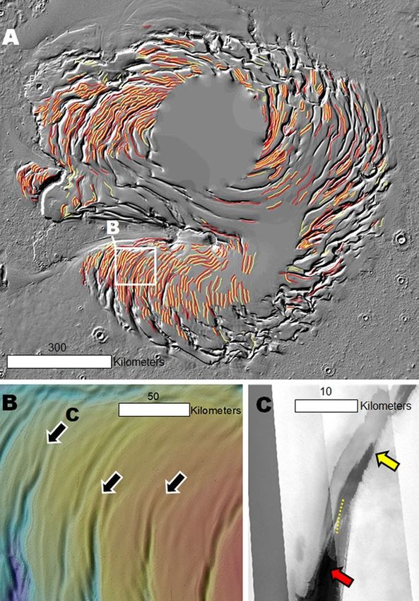
www.nature.com/scientificreports/
Figure 2. (A) Close-up view centered at 85° 10’ N, 110° 59’ W on a PB trough section. The dashed black lines
trace the outlines of several individual cells. See Fig. 1A for context and location. The image is a color MOLA
digital elevation model (512 pixels/degree, credit: MOLA Science Team, MSS, JPL, NASA) draped over part
of a CTX mosaic (6 m/pixel, credit: NASA/JPL. The license terms can be found at pds-imaging.jpl.nasa.gov/
portal/mro_mission.html). (B) Close-up view on panel (A). The dashed white line identifies a group of layers
bounding two cells. The layers have equator and pole-facing exposures. The elevation profile (extracted from
the MOLA DEM) shows that the trough’s total relief (~ 800 m) is bounded by these layers (red dots in panels A
and B identify outcrops). (C) Close-up view on panel (B). View shows examples of layers along the margins of
a cell partly nested between a layered mound and the trough’s equator-facing slope, which clearly demonstrate a
truncation origin. The panels are parts of a CTX mosaic (6 m/pixel, credit: NASA/JPL. The license terms can be
found at pds-imaging.jpl.nasa.gov/portal/mro_mission.html). We produced this figure using Esri’s ArcGIS 10.3
(http://www.esri.com/software/arcgis).
Figure 3. (A) Sketch showing a perspective view of the NPLD stratigraphy, which characterizes widespread
sections of the NPLD troughs. Key morphologic features include the presence of elongate enclosed depressions
(cells), inter-cell ridges, and interior mounds. The mounds and the cell walls exhibit concentrically layered
exposures, indicating that the troughs’ volumes are largely due to in-situ excavation (see Fig. 2 and S4 for
examples of relevant optical and topographic observations). Also indicated is the location of a pole-facing
slope section where young mantles cover the truncated layered outcrops (see Figs. 4, S8, S9 for examples of
relevant optical observations). (B) View of typical trough exposures based on the complete presence or absence
of pole-facing layers (1 and 2) and troughs showing partial mantle obscuration of the underlying truncated
strata (3).
ous spiral arms that are entirely excavated into the NPLD. These arms retain numerous inter-cell ridges and
widespread arcuate cell margins. (3) Spiral troughs without significant gaps with floors that exhume surfaces
situated beneath the NPLD. These arms retain relatively fewer arcuate cell margins and, in their NPLD excavated
segments, exhibit some inter-cell ridges.
Scientific Reports | (2021) 11:6750 | https://doi.org/10.1038/s41598-021-83329-3 4
Vol:.(1234567890)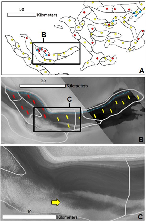
www.nature.com/scientificreports/
Figure 4. (A) View showing a sample of our mapping of the spiral troughs centered at 80°18’ N 19°43’ E.
The black lines outline the cells. The red dots and blue dots, respectively, identify cell floors and mounds with
both equator- and pole-facing strata. The yellow dots identify cells with only equator-facing strata exposures.
(B) Close-up view on panel (A) showing a trough that includes some cells with interior outcrops that exhibit
equator- and pole-facing layers (area marked by red lines) and other cells that show only equator-facing layers
(area marked by yellow lines). These areas share some of the uppermost equator-facing slope layers (blue dotted
line). (C) A close-up view on the trough in panel (B) shows a floor zone with equator- and pole-facing layers
adjoining an area where mantles cover the pole-facing layers (yellow arrow). Panels (B) and (C) are parts of a
CTX mosaic (6 m/pixel, credit: NASA/JPL. The license terms can be found at pds-imaging.jpl.nasa.gov/portal/
mro_mission.html). We produced this figure using Esri’s ArcGIS 10.3 (http://www.esri.com/software/arcgis).
We hypothesize that the following sequence of events links the troughs’ formational history to the spiral
pattern’s emergence (Fig. 6). Following the LLD emplacement and the establishment of the current overall PB
topography, sublimation pits developed over a generally smooth, undissected surface. There could also have been
an older pre-existing population of topographically subtler migrating troughs (Fig. 7).
Spiga and Smith23 performed a wind field simulation over a significant portion of PB (see their Fig. 5) using
the “Laboratoire de Météorologie Dynamique” (LMD) Martian Mesoscale Model (MMM)24,25. Their grid spacing
and horizontal wind vectors were 6.7 km and 50 m, respectively. The simulated wind patterns reveal flow trends
that typically exist orthogonally or obliquely to the troughs. Hence, our conceptual model assumes that winds
did not generally flow along the troughs, but across them.
Troughs generally integrate multiple cells that are typically elliptical or elongate, which include widespread
mounds and exhibit floors without evidence of unidirectional wind erosion (e.g., ridges and grooves transverse to
the troughs). We attribute the elongate cell shapes to erosion by wind vortices (panel A2 in Fig. 6) which generally
developed laterally to katabatic wind flow directions over the troughs. The growth and merging of widespread
cells generated the segmented troughs, which progressively coalesced to form the spiral pattern. While further
computer simulation of wind patterns tailored to high-resolution PB topography is required to validate this
concept, this hypothetical scenario has support in large-eddy simulations that find that counter-rotating heli-
cal vortices played a crucial role in excavating moats, which at widespread locations on Mars, surround crater
interior sedimentary mounds (e.g., Gale crater)26,27.
Scientific Reports | (2021) 11:6750 | https://doi.org/10.1038/s41598-021-83329-3 5
Vol.:(0123456789)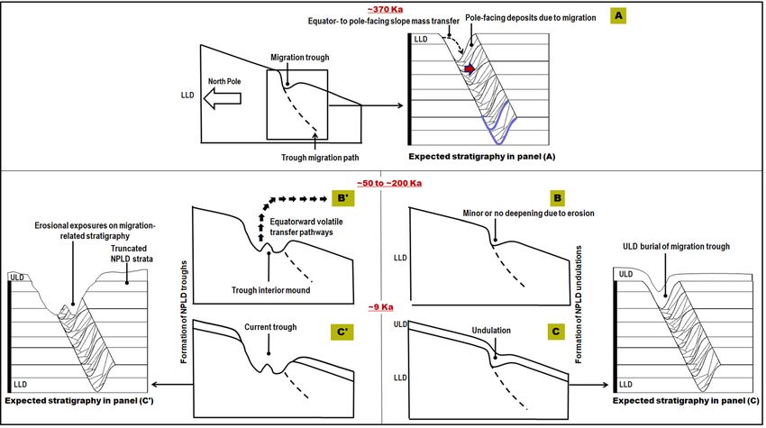
www.nature.com/scientificreports/
Figure 5. View of PB centered at 81° 38’ N, 14° 30’ W with a succession of stair-step trough topography
(elevation profile), which exhibits increasingly wider, deeper, and more longitudinally extensive spiral arms.
Note that we identified the troughs (T1-T5) and undulations (blue dots) situated along the elevation profile’s
path. The two red “X” letters identify zones where the trough floors expose the VBF (i.e., the northern plains
unit, which in this region underlies the NPLD). Despite the troughs’ topographic and spatial complexity, we
find their overall morphologic characteristics reflect varying degrees of development, which broadly fit within
our proposed three zonal categories: (1) PB areas where relatively small troughs form sparse clusters (Zone 1).
(2) Areas where trough junctures reflect widespread intersection relationships which are spatially manifested as
continuous spiral arms. In these areas, the troughs have floors excavated within the NPLD (Zone 2). (3) Areas
where these spiral arms are longer and deeper, are closely spaced, and expose geologic surfaces that underlie
the NPLD. In the context of this figure, the exposed surfaces are part of the VBF (Zone 3). The dashed lines
demark the contacts between Zones 1 & 2 and 2 & 3. All these zones retain a common baseline morphologic
attribute – the preservation of inter-cell ridges (black arrows). This observation is consistent with these spatial
zones, broadly reflecting the temporal sequence of trough development and spiral pattern generation. In Fig. 6,
we graphically present this proposed protracted history of cell enlargement, intersection, and merging leading to
the formation of the spiral arms. Our reconstruction in Fig. 6A is based on the spiral arm connecting troughs T2
and T3. We produced this figure using Esri’s ArcGIS 10.3 (http://www.esri.com/software/arcgis).
Our proposed geologic scenario implies a landscape evolution in which pits developed into cells, and cells
progressively merged into troughs. While most of the troughs would have interlaced through vertex-to-vertex
interconnections (explaining their typical longitudinal continuity), vertex-to-midsection intersections produced
widespread forking patterns (e.g., Fig. S7). As long chains of troughs became joined, the regional spiral pattern
developed. Our model resolves that the trough spiral pattern is an in-situ erosional spatial byproduct, and there-
fore did not result from the poleward migration of initially randomly distributed t roughs21.
The shallowly eroded concentric layers exposed along many cell vertices (e.g., Figs. 2, S6, S8) indicate cell
growth occurred within the uppermost surface and near-surface NPLD stratigraphy, and not into a pre-existing
troughed and reworked topography. Hence, the hypothesized pits/migrating troughs from which the cells could
have initially nucleated probably were widely spaced apart, consistent with a progressive history of trough growth
into the spiral arms.
Due to the polar plateau’s domical shape, the extent of equator-facing surfaces (and hence the expected mag-
nitude of insolation-driven sublimation) increases with distance from the pole. Possibly, the erosive power of
wind vortices that developed within the pits and growing cells also increased near the plateau’s margins due to
increases in slope and entrainment of fines. Consequently, while the sublimation pits’ initial distribution was
Scientific Reports | (2021) 11:6750 | https://doi.org/10.1038/s41598-021-83329-3 6
Vol:.(1234567890)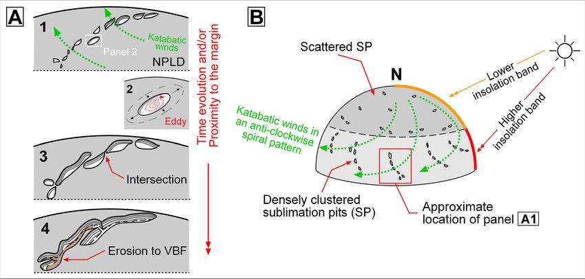
www.nature.com/scientificreports/
Figure 6. Sketches showing a geologic scenario that explains the formation of the north polar spiral troughs.
Our model departs from the assumption that after the NPLD accumulated, PB had a smooth overall domical
shape. Solar heating produced widespread sublimation pits (A1,B), predominantly clustered along the polar
plateau’s periphery due to higher insolation (B). The sublimation pits gradually grew obliquely to the direction
of katabatic winds, which have flow directions patterned in an anticlockwise spiral. The apparently enhanced
erosion linked to lateral wind dispersion might have been related to the development of powerful wind vortices
(A2,A3). As the troughs grew and deepened, their intersections increased, leading to the emergence of spiral
arms, which, while mostly dissected within the NPLD, locally expose underlying geologic units (A4). The spiral
arm shown in panel A3 is a reconstruction of that which includes troughs labeled T2 and T3 in Fig. 5.
probably random, their subsequent growth would have been greater closer to PB’s periphery, where the troughs
are most developed and best integrated.
Evidence of widespread buried troughs. We produced the first comprehensive map of the PB undula-
tions. The map reveals that the undulations follow and extend the troughs’ clockwise spiraling pattern, particu-
larly on upper plateau surfaces (Fig. 8A). Locally, they transition into troughs (Fig. 8B,C). Undulations thus may
be the surface expressions of relatively narrow and shallow trough sections that are now entirely buried by the
ULD. In this scenario, before the ULD emplacement, a large subset of these older troughs experienced an epi-
sode of erosion, coalescence, and enlargement along their original pattern. This phase of erosion could have led
to the development of the stratal truncation morphologies that we observe within the troughs (Figs. 1B, 2A–C,
S4–S8). Hence, the total volume of excavated NPLD ice during trough development could exceed our ~ 4 × 10⁴
km3 estimate. A consequence of this geologic scenario is that the spiral pattern must have also developed before
ULD emplacement.
Discussion
Constraints on the timing of NPLD trough formation. Our interpretation of the undulations as
ULD-buried trough sections implies that the troughs developed largely after the accumulation of the L LD1,7,
7
and before ULD deposition ~ 10 Ka . The age of the LLD trough strata remains uncertain, with estimates ranging
from ~ 3.6 ± 2.5 Ma7 to ~ 370 Ka13. The younger age bracket for trough development (between ~ 370 Ka and ~ 10
Ka) suggests that trough development could represent evidence for one of the most recent episodes of climate
change on Mars. There is additional evidence of potential warmer paleoclimates slightly more recent than ~ 370
Ka. For example, the migration of aeolian bedforms in the Meridiani region ~ 50–200 Ka28 is interpreted as an
indicator of a significant increase in Mars’ atmospheric density and pressure. There are also possible aqueous
debris flows from ∼ 190 Ka29 in Istok crater (45.11° S, 274.2° E), a very young crater in Aonia Terra. Perhaps the
water ice removal recorded in the uppermost sequences of the NPLD exposures along troughs’ walls and floors
was coeval with these recent paleoclimate events.
Conversely, if the LLD surfaces exposed within the troughs are ~ 3.6 ± 2.5 M a7, the geologic scenario arises that
trough excavation might have been a cumulative process spanning numerous high-obliquity cycles. In this case,
the larger troughs, mostly along the PB periphery, would have likely been exposed to more intense and reoccur-
ring resurfacing during these cycles. Hence, they might be sites where alternating erosion and deposition more
frequently took place during trough excavation, particularly in areas where NPLD sediments were remobilized
and not completely removed from these larger troughs. Evidence of these intercalated inner-trough erosional
depositional cycles is preserved as widespread unconformities mapped in some of these larger trough s ets7.
Scientific Reports | (2021) 11:6750 | https://doi.org/10.1038/s41598-021-83329-3 7
Vol.:(0123456789)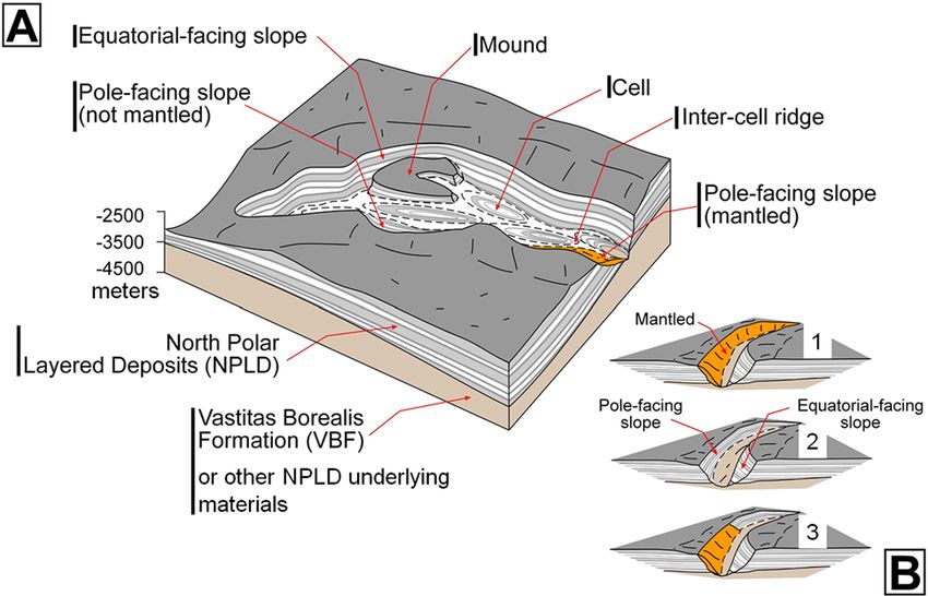
www.nature.com/scientificreports/
Figure 7. Sketches depicting how poleward trough migration could have shaped the NPLD stratigraphy
associated with undulations (A–C), and trough interior stratal truncation morphologies (A–C’). (A) Following
Mars’ last ice age ~ 370 Ka as proposed by Smith et al.13, polar ice accumulation during low mean obliquity led
to the emplacement of the top few hundred meters of the LLD, concurrently with the poleward migration of
troughs, which resulted in the formation of radar detectable migration pathways. The indigo lines trace buried,
paleotrough surfaces, expected to have remained preserved within the NPLD as the trough migrated. Above
these paleosurfaces, we expect to find cross-bedding (red arrow) forming cross-sectional stratal geometries
resulting from sustained deposition on the inclined, migrating, pole-facing slopes. (B,B’) A geologically recent
phase of surface erosion, probably ~ 50–200 Ka28, resulted in significant, heterogeneously distributed, polar ice
removal. Panel (B) shows a migrating trough that experienced no or little erosional deepening during this stage.
Panel (B’) shows a migrating trough that experienced significant erosional deepening during this period. (C)
The ULD were emplaced ~ 9 Ka1,7 and buried some troughs, topographically muting them and resulting in the
formation of the undulations. The proposed migration ceases at this point. (C’) The ULD are emplaced ~ 9 Ka1,7
and retained on the trough surroundings but appear to have heterogeneously retreated from inside the eroded
troughs, or alternatively, the trough interiors lacked a favorable depositional environment for the ULD. The
expected stratigraphy sketches shown in this figure comprise predictions that need to be validated through
comparison of our observations to those on which the proposed cross-sections for scenarios of poleward
migration were based on (-also see Fig. 3c in Smith and Holt16 and Fig. 5 in Smith and Holt19-).
Trough excavated ice as a source of the mid‑latitude mantles. Three-dimensional Global Climate
Models [GCMs] indicate that PB water ice sublimation3 during periods of high mean obliquity (> 35°) trans-
ported enormous water vapor volumes to lower latitudes3,5,8. Recondensing water vapor likely formed wide-
spread lower latitude icy deposits, including the extensive Latitude Dependent Mantle (LDM)30, plains regions
with evidence of excess ice31–34 and glaciers at mid-latitudes35,36. Moreover, this atmospheric and paleoclimatic
cyclicity is thought to have also generated tropical mountain glaciers8,37. However, thus far, these atmospheric
models face a significant handicap — their implied large-scale NPLD erosional events, which led to the equa-
torward water vapor transport, have not been successfully reconciled with direct observational evidence in the
exposed stratigraphy. The evidence to support these events was limited to the documentation of unconformities
inferred from theoretical stratigraphic reconstructions3 and radar subsurface detections13.
Our proposed geologic scenario fills this gap by interpreting the entire spiral PB troughs as erosional land-
forms. We estimated that trough excavation could have removed ~ 4 × 10⁴ km3 of water ice from PB (Fig. S11).
Comparing this result to the estimate of the LDM volume (~ 1 m Global Equivalent Layer (GEL)38, corresponding
to ~ 1.4 × 10⁵ km3), leads us to conclude that upwards of ~ 25% of the ice deposited at non-polar latitudes to form
the LDM could have originated from the ice lost in the polar erosional event we propose here. This approximation
does not include the potentially coeval retreat of a circum-polar ice sheet, which Tanaka7 reconstructed based
on the mapping and characterization of numerous NPLD outliers, nor from a potential mass of eroded volatiles
from the ULD-buried troughs that now form the undulations, as hypothesized above.
Scientific Reports | (2021) 11:6750 | https://doi.org/10.1038/s41598-021-83329-3 8
Vol:.(1234567890)www.nature.com/scientificreports/
Figure 8. (A) Map showing the undulations of PB. The yellow lines trace the floors and the red lines trace the
adjoining ridges. The base map is a MOLA shaded relief, illumination from the upper left (256 pixels/degree,
credit: MOLA Science Team, MSS, JPL, NASA). (B) A close-up view shows troughs connected to undulations
(black arrows show nexus points). The image is a color MOLA digital elevation model draped over a MOLA
shaded relief; illumination from the upper left (256 pixels/degree, credit: MOLA Science Team, MSS, JPL,
NASA). (C) View of dark lithic materials at the nexus between a trough (red arrow) and an undulation (yellow
arrow). The dashed line identifies the contact between the undulation and the trough. The panel is part of a
CTX mosaic (6 m/pixel, credit: NASA/JPL. The license terms can be found at pds-imaging.jpl.nasa.gov/portal/
mro_mission.html). We produced this figure using Esri’s ArcGIS 10.3 (http://www.esri.com/software/arcgis).
Significance for future human exploration. The assumption of the recent timeline (e.g., ~200–50 Ka)
for the polar erosional event carries potentially significant implications for future human exploration. Following
the proposed water vapor deposition at lower, non-polar latitudes, these young deposits would not have existed
sufficiently long to experience large obliquity excursions. Hence, they would have remained wholly frozen dur-
ing their entire post-depositional history, avoiding possible episodic interstitial thawing and refreezing such as
that associated with wet-based glaciation31,36. Transient melting would have dissolved and increased within these
materials the concentration of perchlorates, a widespread Martian surface compound and toxic to h umans39.
Hence, these young “clean” ice deposits could be an essential resource for future human explorers. We esti-
mated that ~ 40,000 km3 of water ice were removed during trough growth, which is volumetrically equivalent
to 16 billion Olympic pools. Drinking three liters a day would take 2283 years for a single person to drink an
Olympic-sized pool.
Additionally, the deposits’ youthfulness implies that they likely formed widespread near-surface stratigraphy,
enabling easy access. Such deposition may account for the relatively pure water ice beneath a centimeters-thick
soil cover discovered by the Phoenix lander in the high latitudes of the northern p lains40 or shallowly buried
41,42
water ice within the upper meter of the Martian surface at the mid-latitudes .
Synthesis of trough observations: general constraints on their mode of formation
We propose that future investigations regarding the origin and evolution of the NPLD troughs need to account
for the following observations and related interpretations:
1. Stratigraphy in trough walls reveals that layering is horizontal and occurs evenly, with uniform thicknesses,
in the plateau wall all around the troughs. Hence, the bulk of the exposed stratigraphy consists of layers that
were emplaced during the construction of PB.
2. The mantles on pole-facing slopes (Figs. 4, S6, S8, S9) are mostly disconnected from the current troughs’
origin and distribution.
3. Trough, undulation, and layer geometries indicate in-situ erosion on the LLD surface, below the ULD.
Troughs tend to be deeper, wider, and more connected toward the margins of PB, where some trough floors
expose basal unit and Vastitas plains materials. Hence, their in-situ excavation might have been enhanced
throughout the more steeply sloping areas of PB, probably due to increased insolation on these areas when
compared to the flatter, and more central (hence higher latitude), parts of the polar plateau (Fig. 6).
Scientific Reports | (2021) 11:6750 | https://doi.org/10.1038/s41598-021-83329-3 9
Vol.:(0123456789)www.nature.com/scientificreports/
4. The cells and troughs exhibit complex intersections from which their spiral distribution emerges, suggesting
that the pattern is a late-stage consequence of the troughs’ erosional history. The troughs’ growth patterns
reflect an overall growth trend in directions orthogonal or oblique to regional katabatic winds, suggesting a
possible morphogenetic connection.
5. The troughs largely ceased developing before ULD accumulation, given that apparently these materials
completely filled some of their sections (i.e., undulations). Hence, Mars’ current and recent climate does not
include the atmospheric conditions that led to trough formation and the development of the spiral pattern.
Conclusions and major remaining issues
Our geologic investigation reveals widespread segmentation of the north polar troughs, which most likely
resulted during geologically recent in-situ erosion. The inferred growth trends are consistent with the erosion
occurring preferentially orthogonally and obliquely to katabatic wind directions and suggest that the spiral pat-
tern is a consequence of the troughs’ progressive spatial integration. Furthermore, the spiral pattern’s connection
to landforms indicative of cell and trough intersections implies that there has been no appreciable repositioning
of the trough axes subsequent to (and during) the emergence of the spiral arrangement. Our hypothesis explains
that the troughs’ spiral trends developed over the plateau’s current topography. A similar in-situ erosional history
was also likely responsible for the origin of the south polar spiral troughs43,44.
Major uncertainties and controversies that remain unresolved include:
1. A non-migratory nature of the polar troughs implies that the strata that they expose on both their equator
and pole-facing slopes can be linked to paleoclimatic conditions accompanying the construction of the
Martian polar plateaus. If, as previously proposed1, the NPLD contain layers deposited during the last billion
years, then formation of the troughs could have exposed a paleoclimatic record spanning about a fourth of
the planet’s geologic history. If on the other hand, the NPLD formed during the last 4 M yrs3, the exposed
layers likely comprise an extensive paleoclimatic record of the geologically recent evolution of the Martian
paleoclimate.
2. SHARAD subsurface radar data characterizations in Smith and Holt16,19 show possible trough migration
paths beneath some of the undulations. If the undulations present within these areas are indeed buried
migratory troughs, a reasonable prediction is that their migration paths would (1) trace a shrinking spiral
(if the migrating troughs’ initial distribution was more peripheral and spiral), or (2) the pathways that led
to the emergence of the spiral pattern (if their original distribution was randomized21). However, due to the
orbital inclination of the Mars Reconnaissance Orbiter, the innermost areas of PB lack observations, which
makes these determinations challenging.
3. The interpretation that inclined radar discontinuities are trough migration paths is partly based on the
observation that their uppermost zones terminate right beneath trough floors. However, it remains unclear
whether other geologic scenarios could explain the radar-reconstructed stratigraphy. For example, some of
these could be buried unconformities, which in the past surfaced at breaks-in-slope (Fig. S13). Troughs could
have preferentially developed on the slope breaks due to enhanced erosion (perhaps due to preferential dark
lithic mantling, probably dust). The formation of these troughs would have resulted in virtually the same
NPLD stratigraphy as that documented to support the migration scenario. Further testing of this hypothesis
includes (1) determining whether these other types of unconformities could be present in at least a subset
of the troughs, (2) identifying if there are any radar signatures similar to the proposed migration paths that
extend to the surface with no associated trough.
Received: 15 May 2020; Accepted: 28 January 2021
References
1. Tanaka, K. L. et al. North polar region of Mars: Advances in stratigraphy, structure, and erosional modification. Icarus 196(2),
318–358. https://doi.org/10.1016/j.icarus.2008.01.021 (2008).
2. Tanaka, K. L. & Fortezzo, C. M. Geologic map of the north polar region of Mars: U.S. Geological Survey Scientific Investigations
Map 3177, pamphlet 11 p., 1 sheet, scale 1:2,000,000. https://pubs.usgs.gov/sim/3177/ (2012).
3. Levrard, B., Forget, F., Montmessin, F. & Laskar, J. Recent formation and evolution of northern Martian polar layered deposits as
inferred from a global climate model. J. Geophys. Res. 112, E06012. https://doi.org/10.1029/2006JE002772 (2007).
4. Laskar, J., Levrard, B. & Mustard, J. F. Orbital forcing of the martian polar layered deposits. Nature 419, 375–377. https://doi.org/
10.1038/nature01066 (2002).
5. Levrard, B., Forget, F., Montmessin, F. & Laskar, J. Recent ice-rich deposits formed at high-latitudes on Mars by sublimation of
unstable equatorial ice during low obliquity. Nature 431, 1072–1075. https://doi.org/10.1038/nature03055 (2004).
6. Milkovich, S. & Head, J. W. North polar cap of Mars: Polar layered deposit characterization and identification of a fundamental
climate signal. J. Geophys. Res. 110, 1. https://doi.org/10.1029/2004JE002349 (2005).
7. Tanaka, K. Geology and insolation-driven climatic history of Amazonian north polar materials on Mars. Nature 437, 991–
994. https://doi.org/10.1038/nature04065 (2005).
8. Forget, F., Haberle, R. M., Montmessin, F., Levrard, B. & Head, J. W. Formation of glaciers on Mars by atmospheric precipitation
at high obliquity. Science 311(5759), 368–371. https://doi.org/10.1126/science.1120335 (2006).
9. Hvidberg, C. S. et al. Reading the climate record of the Martian polar layered deposits. Icarus 221(1), 405–419. https://doi.org/10.
1016/j.icarus.2012.08.009 (2012).
10. Rodriguez, J. A. P. et al. Recent aeolian erosion and deposition in the north polar plateau of Mars. Mars 3, 29–41. https://doi.org/
10.1555/mars.2007.0003 (2007).
Scientific Reports | (2021) 11:6750 | https://doi.org/10.1038/s41598-021-83329-3 10
Vol:.(1234567890)www.nature.com/scientificreports/
11. Rodriguez, J. A. P. & Tanaka, K. L. Evidence for in-situ trough erosion in Planum Boreum, Mars, Fifth International Conference
on Mars Polar Science and Exploration, 1323, Abstract 6015 (2011).
12. Tanaka, K. L., Skinner, J. A. & Hare, T. M. Geologic map of the northern plains of Mars. U.S. Geological Survey Scientific Investiga-
tions Map 2888, scale 1:15,000,000 (1 mm = 15 km) at 90° N and 1:7,500,000 at 0° N. http://pubs.usgs.gov/sim/2005/2888/ (2005).
13. Smith, I. B., Putzig, N. E., Holt, J. W. & Phillips, R. J. An ice age recorded in the polar deposits on Mars. Science 352(6289),
1075–1078. https://doi.org/10.1126/science.aad6968 (2016).
14. Howard, A. Origin of the stepped topography of the martian poles. Icarus 34(3), 581–599. https://doi.org/10.1016/0019-1035(78)
90047-7 (1978).
15. Howard, A. The role of eolian processes in forming surface features of the martian polar layered deposits. Icarus 144, 267–
288. https://doi.org/10.1006/icar.1999.6305 (2000).
16. Smith, I. B. & Holt, J. W. Onset and migration of spiral troughs on Mars revealed by orbital radar. Nature 465, 450–453. https://
doi.org/10.1038/nature09049 (2010).
17. Smith, I. B., Holt, J. W., Spiga, A., Howard, A. D. & Parker, G. The spiral troughs of Mars as cyclic steps. J. Geophys. Res. 118,
1835–1857. https://doi.org/10.1002/jgre.20142 (2013).
18. Herny, C. et al. Sedimentation waves on the Martian North Polar Cap: Analogy with megadunes in Antarctica. Earth Planet. Sci.
Lett. 403, 56–66. https://doi.org/10.1016/j.epsl.2014.06.033 (2014).
19. Smith, I. B. & Holt, J. W. Spiral trough diversity on the north pole of Mars, as seen by Shallow Radar (SHARAD). J. Geophys. Res.
120, 362–387. https://doi.org/10.1002/2014JE004720 (2015).
20. Bramson, A. M. et al. A migration model for the polar spiral troughs of Mars. J. Geophys. Res. 124(4), 1020–1043. https://doi.org/
10.1029/2018JE005806 (2019).
21. Pelletier, J. D. How do spiral troughs form on Mars?. Geology 32(4), 365–367. https://doi.org/10.1130/G20228.1 (2004).
22. Howard, A. D., Cutts, J. A. & Blasius, K. R. Stratigraphic relationships within Martian polar cap deposits. Icarus 50(2–3), 161–215.
https://doi.org/10.1016/0019-1035(82)90123-3 (1982).
23. Spiga, A. & Smith, I. Katabatic jumps in the Martian northern polar regions. Icarus 308, 197–208. https://doi.org/10.1016/j.icarus.
2017.10.021 (2018).
24. Spiga, A. & Forget, F. A new model to simulate the martian mesoscale and microscale atmospheric circulation: Validation and first
results. J. Geophys. Res. 114, E2. https://doi.org/10.1029/2008JE003242 (2009).
25. Spiga, A. et al. The impact of martian mesoscale winds on surface temperature and on the determination of thermal inertia. Icarus
212(2), 504–519. https://doi.org/10.1016/j.icarus.2011.02.001 (2011).
26. Anderson, W. & Day, M. Turbulent flow over craters on Mars: Vorticity dynamics reveal aeolian excavation mechanism. Phys. Rev.
E96, 043110. https://doi.org/10.1103/PhysRevE.96.043110 (2017).
27. Steele, L. J., Kite, E. S. & Michaels, T. I. Crater mound formation by wind erosion on Mars. J. Geophys. Res. 123, 113–130. https://
doi.org/10.1002/2017JE005459 (2018).
28. Fenton, L. K., Carson, H. C. & Michaels, T. I. Climate forcing of ripple migration and crest alignment in the last 400 kyr in Meridiani
Planum Mars. J. Geophys. Res. 123, 849–863. https://doi.org/10.1002/2017JE005503 (2018).
29. de Haas, T. et al. Earth-like aqueous debris-flow activity on Mars at high orbital obliquity in the last million years. Nat. Commun.
6, 7543. https://doi.org/10.1038/ncomms8543 (2015).
30. Kreslavsky, M. A. & Head, J. W. Mars: Nature and evolution of young latitude-dependent water ice-rich mantle. Geophys. Res. Lett.
29(15), 1719. https://doi.org/10.1029/2002GL015392 (2002).
31. Bramson, A. M. et al. Widespread excess ice in Arcadia Planitia Mars. Geophys. Res. Lett. 42, 6566–6574. https://doi.org/10.1002/
2015GL064844 (2015).
32. Dundas, C. M. et al. HiRISE observations of new impact craters exposing Martian ground ice. J. Geophys. Res. 119, 1. https://doi.
org/10.1002/2013JE004482 (2014).
33. Dundas, C. M. et al. Exposed subsurface ice sheets in the Martian mid-latitudes. Science 359(6372), 199–201. https://doi.org/10.
1126/science.aao1619 (2018).
34. Stuurman, C. M. et al. SHARAD detection and characterization of subsurface water ice deposits in Utopia Planitia Mars. Geophys.
Res. Lett. 43, 9484–9491. https://doi.org/10.1002/2016GL070138 (2016).
35. Head, J. W. et al. Extensive valley glacier deposits in the northern mid-latitudes of Mars: Evidence for late Amazonian obliquity-
driven climate change. Earth Planet. Sci. Lett. 241(3-4), 663–671. https://doi.org/10.1016/j.epsl.2005.11.016 (2006).
36. Holt, J. W. et al. Radar Sounding Evidence for Buried Glaciers in the Southern Mid-Latitudes of Mars. Science 322(5905), 1235–
1238. https://doi.org/10.1126/science.1164246 (2008).
37. Head, J. W. & Marchant, D. R. Cold-based mountain glaciers on Mars: Western Arsia Mons. Geology 31(7), 641–644. https://doi.
org/10.1130/0091-7613(2003)0312.0.CO;2 (2003).
38. Head, J. W., Mustard, J. F., Kreslavsky, M. A., Milliken, R. E. & Marchant, D. R. Recent ice ages on Mars. Nature 426, 797–802.
https://doi.org/10.1038/nature02114 (2003).
39. Davila, A. F. et al. Perchlorate on Mars: A chemical hazard and a resource for humans. Int. J. Astrobiol. 12(4), 321–325. https://doi.
org/10.1017/S1473550413000189 (2013).
40. Smith, P. H. et al. H2O at the Phoenix landing site. Science 325(5936), 58–61. https://doi.org/10.1126/science.1172339 (2009).
41. Pathare, A. V. et al. Driven by excess? climatic implications of new global mapping of near-surface water-equivalent hydrogen on
Mars. Icarus 301, 97–116 https://doi.org/10.1016/j.icarus.2017.09.031 (2018).
42. Morgan, G.A. et al. Availability of subsurface water-ice resources in the northern mid-latitudes of Mars. Nat Astron. https://doi.
org/10.1038/s41550-020-01290-z (2021).
43. Rodriguez, J. A. P. et al. New insights into the Late Amazonian zonal shrinkage of the martian south polar plateau. Icarus 248,
407–411. https://doi.org/10.1016/j.icarus.2014.08.047 (2015).
44. Kolb, E. J. & Tanaka, K. L. Accumulation and erosion of south polar layered deposits in the Promethei Lingula region, Planum
Australe Mars. Mars 2, 1–9. https://doi.org/10.1555/mars.2006.0001 (2006).
Acknowledgements
Alexis Rodriguez was supported by MDAP Grant# NNX15AF18G. We are grateful to Dr. Vincent F Chevrier
and two anonymous reviewers whose comments significantly improved this manuscript. Alexis Rodriguez and
Mario Zarroca are grateful to Rogelio Linares for his insights during the early development of this manuscript.
Author contributions
J.A.P.R. developed the core hypotheses, produced Figs. 1, 2, 4, 5, 7, and 8, Figs. S1–S10, S13. K.L.T. and A.M.B.
significantly contributed to writing and science development. G.J.L., V.R.B., and M.Z. also helped refine the writ-
ing and science. G.J.L. produced figures S11 and S12. M.Z. produced Figs. 3 and 6. G.J.L. calculated the troughs
erosional volumes and A.M.B. their percentage correlation to those of the mid-latitude mantles.
Scientific Reports | (2021) 11:6750 | https://doi.org/10.1038/s41598-021-83329-3 11
Vol.:(0123456789)www.nature.com/scientificreports/
Competing interests
The authors declare no competing interests.
Additional information
Supplementary Information The online version contains supplementary material available at https://doi.org/
10.1038/s41598-021-83329-3.
Correspondence and requests for materials should be addressed to J.A.P.R.
Reprints and permissions information is available at www.nature.com/reprints.
Publisher’s note Springer Nature remains neutral with regard to jurisdictional claims in published maps and
institutional affiliations.
Open Access This article is licensed under a Creative Commons Attribution 4.0 International
License, which permits use, sharing, adaptation, distribution and reproduction in any medium or
format, as long as you give appropriate credit to the original author(s) and the source, provide a link to the
Creative Commons licence, and indicate if changes were made. The images or other third party material in this
article are included in the article’s Creative Commons licence, unless indicated otherwise in a credit line to the
material. If material is not included in the article’s Creative Commons licence and your intended use is not
permitted by statutory regulation or exceeds the permitted use, you will need to obtain permission directly from
the copyright holder. To view a copy of this licence, visit http://creativecommons.org/licenses/by/4.0/.
© The Author(s) 2021
Scientific Reports | (2021) 11:6750 | https://doi.org/10.1038/s41598-021-83329-3 12
Vol:.(1234567890)You can also read