North Sea salt-marsh archives trace past storminess and climate variability - HENRY
←
→
Page content transcription
If your browser does not render page correctly, please read the page content below
Article, Accepted Version

Bunzel, Dorothea; Milker, Yvonne; Müller-Navarra, Katharina; Arz, Helge
Wolfgang; Schmiedl, Gerhard
North Sea salt-marsh archives trace past storminess and
climate variability
Global and Planetary Change

Verfügbar unter/Available at: https://hdl.handle.net/20.500.11970/107609

Vorgeschlagene Zitierweise/Suggested citation:
Bunzel, Dorothea; Milker, Yvonne; Müller-Navarra, Katharina; Arz, Helge Wolfgang;
Schmiedl, Gerhard (2021): North Sea salt-marsh archives trace past storminess and climate
variability. In: Global and Planetary Change 198. S. 103403.
https://doi.org/10.1016/j.gloplacha.2020.103403.

Standardnutzungsbedingungen/Terms of Use:

Die Dokumente in HENRY stehen unter der Creative Commons Lizenz CC BY 4.0, sofern keine abweichenden
Nutzungsbedingungen getroffen wurden. Damit ist sowohl die kommerzielle Nutzung als auch das Teilen, die
Weiterbearbeitung und Speicherung erlaubt. Das Verwenden und das Bearbeiten stehen unter der Bedingung der
Namensnennung. Im Einzelfall kann eine restriktivere Lizenz gelten; dann gelten abweichend von den obigen
Nutzungsbedingungen die in der dort genannten Lizenz gewährten Nutzungsrechte.
Documents in HENRY are made available under the Creative Commons License CC BY 4.0, if no other license is
applicable. Under CC BY 4.0 commercial use and sharing, remixing, transforming, and building upon the material
of the work is permitted. In some cases a different, more restrictive license may apply; if applicable the terms of
the restrictive license will be binding.
Global and Planetary Change 198 (2021) 103403

                                                                    Contents lists available at ScienceDirect

                                                            Global and Planetary Change
                                                        journal homepage: www.elsevier.com/locate/gloplacha

Research article

North Sea salt-marsh archives trace past storminess and climate variability
Dorothea Bunzel a, *, Yvonne Milker a, Katharina Müller-Navarra b, Helge Wolfgang Arz c,
Gerhard Schmiedl a
a
  Center for Earth System Research and Sustainability (CEN), Institute for Geology, Universität Hamburg, Bundesstrasse 55, D-20146 Hamburg, Germany
b
  Federal Waterways Engineering and Research Institute (BAW), Wedeler Landstraße 157, D-22559 Hamburg, Germany
c
  Leibniz Institute for Baltic Sea Research Warnemünde (IOW), Seestrasse 15, D-18119 Rostock, Germany

A R T I C L E I N F O                                     A B S T R A C T

Keywords:                                                 Intertidal coastal wetlands are regularly exposed to storm surges and associated flooding, resulting in the
Salt Marshes                                              recurrent accretion of reworked sediments on the salt-marsh surfaces. In this context, well-stratified salt-marsh
North Sea                                                 sediment sequences provide an exceptional archive to evaluate the response of coastal wetlands to past storm-
Storminess
                                                          climate variability. Hence, this study focusses on the investigation of two sedimentary salt-marsh sequences
Climate Oscillations
Anthropogenic Interventions
                                                          from the south-eastern German North Sea coast (Bay of Tümlau and Friedrichskoog) to understand how and to
                                                          which extent changes in the storm-surge climate are transferred into the sediment archive. This objective is
                                                          particularly challenging as German mainland salt marshes have been greatly altered by human activities over the
                                                          last century. To overcome this problem, this study combines different sedimentological and geochemical proxy
                                                          data, using mean grain sizes together with ln(Br/Cl), Br/Corg, and ln(Zr/Rb) ratios, to allow for the identification
                                                          of storm-surge layers. Local changes in the sedimentary organic matter supply are reflected by the ln(Br/Cl) ratio.
                                                          There, abrupt drops in the ln(Br/Cl) data coincide with relatively coarser textured sand layers, indicating impacts
                                                          by regional storm surges during winter, while intervals of comparable higher ln(Br/Cl) values may represent
                                                          deposition during spring to fall. The Br/Corg record reflects the marine versus terrestrial organic matter input and
                                                          reveals a long-term increase starting during the first half of the 20th century towards recent times, resembling the
                                                          observed amplification in North Sea storminess. A similar trend is reflected by the ln(Zr/Rb) ratio (since 1950
                                                          CE), which can be used as a proxy for the grain-size distribution. Periodic fluctuations in the ln(Zr/Rb) ratio at
                                                          inter-decadal timescales (10–19 years) suggest a close linkage between local sediment accretion and large-scale
                                                          atmosphere-ocean climate oscillations over the North Atlantic and Europe, and thus related storm-surge fre-
                                                          quency and intensity. Periodic variability on decadal scales was also identified in the ln(Br/Cl) record at the less
                                                          human-modified and more naturally developed salt marsh at the Bay of Tümlau (12–22 years), likewise indi-
                                                          cating a relation between North Sea storminess and associated shifts in the seasonal signal of the primary pro-
                                                          duction and sediment texture to oscillations in the atmosphere-ocean system. On the contrary, similar
                                                          periodicities are lacking for the intense modified salt marsh at Friedrichskoog. Apparently, the salt-marsh
                                                          depositional system in the Bay of Tümlau reacts more sensitively to super-regional climatic changes, respec-
                                                          tively, the natural depositional processes in the salt marsh at Friedrichskoog are superimposed by the more
                                                          intense local human activities.

1. Introduction                                                                                erosion, relocation, and re-deposition of sediments, and can therefore
                                                                                               lead to the loss of salt marshes at some places, but at the same time
   Sedimentation in active salt marshes is mainly controlled by the                            provide the required sediment supply for the growth of salt marshes at
complex dynamics of mean sea level (MSL), tides, and storm surges (e.g.,                       other sites (Allen 1990; Temmerman et al. 2003; Mariotti and Fagher-
Allen 2000; Davy et al. 2009; Stevenson and Kearney 2009; Haigh et al.                         azzi 2010; Andersen et al. 2011; Schuerch et al. 2013, 2019; Kirwan
2010). These hydrodynamic processes are responsible for the local                              et al. 2016). The mobilization of sediments further depends on the

 * Corresponding author at: Institute for Geology, CEN, Universität Hamburg, Bundesstrasse 55, D-20146 Hamburg, Germany.
   E-mail addresses: dorothea.bunzel@uni-hamburg.de (D. Bunzel), yvonne.milker@uni-hamburg.de (Y. Milker), katharina.mueller-navarra@baw.de (K. Müller-
Navarra), helge.arz@io-warnemuende.de (H.W. Arz), gerhard.schmiedl@uni-hamburg.de (G. Schmiedl).

https://doi.org/10.1016/j.gloplacha.2020.103403
Received 23 July 2020; Received in revised form 4 December 2020; Accepted 18 December 2020
Available online 23 December 2020
0921-8181/© 2020 The Authors. Published by Elsevier B.V. This is an open access article under the CC BY license (http://creativecommons.org/licenses/by/4.0/).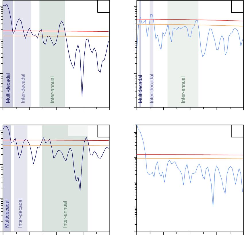
D. Bunzel et al.                                                                                                      Global and Planetary Change 198 (2021) 103403

exposure of a salt marsh to wave energy, and its geomorphology (e.g.,               management. In order to test this hypothesis, this study explores how
Allen 2000; Mariotti and Fagherazzi 2010). The composition of the                   the present human-modified salt marshes have responded to climate
reworked suspended sediments, which are introduced onto the salt                    changes during the past century, how the storm-climate signal is
marsh by recurrent floods, and thereby contribute to their vertical                 transferred into the sediment sequences, and how this signal can be
growth, reflects the availability of material originating from the adja-            distinguished from the anthropogenic signals. Commonly, discrete
cent tidal flats and eroded marshes (Müller-Navarra et al. 2019;                    storm-surge layers are described as being dominated by siliciclastic
Schuerch et al. 2019; Bunzel et al. 2020), as well as from rivers (Eisma            coarser-grained sediments (e.g., Ehlers et al. 1993; Chaumillon et al.
and Irion 1988). The accretion of sediments on top of the marsh surface             2017), but vary in thickness and composition, often impeding a detailed
finally depends on the vegetation cover and structure (Nolte et al. 2013;           evaluation based on classical sedimentological analyses. In this context,
Mariotti and Fagherazzi 2010; Fagherazzi 2014; Möller et al. 2014).                geochemical analyses by high-resolution X-ray fluorescence (XRF)
Similar processes are also active along the North Sea coast, where spe-             scanning may add detailed information on salt-marsh sedimentation
cifically the recurrent flooding during storm surges results in the accu-           dynamics on short timescales and may provide additional proxies for the
mulation of well-stratified salt-marsh sequences, providing a potential             identification of storm-surge layers. Based on that, this study follows an
high-resolution archive of past storm-surge dynamics and climate                    integrated approach by evaluating different sedimentological and
changes.                                                                            geochemical proxy data, including grain size, organic carbon, and XRF
    The North Sea coastline is exposed to annual storm surges, specif-              scanning data (Br, Cl, Rb, and Zr). These data were obtained from two
ically during winter times (e.g., Gerber et al. 2016). The surge heights            sediment sequences originating from different salt-marsh environments
are either raised by local wind stress pushing the water towards the                at the south-eastern German North Sea coast and have undergone
coastline (Weisse and von Storch 2010), or by strong atmospheric low-               similar natural climate processes but experienced different degrees of
pressure centres that are formed over the North Atlantic and then                   anthropogenic interventions during the last century. The extracted
move across the North Sea (e.g., Müller-Navarra and Giese 1999).                    climate component is used to explore the complexity of the regional
During the last century, storm surges were additionally influenced by               storm-surge history and its linkage to underlying super-regional climate
the long-term increase of regional MSL (2.4 ± 0.1 mm yr−1 between                   oscillations.
1871 and 2008 CE) under the influence of global warming (Dangendorf
et al. 2013a). Particularly in shallow coastal areas, such as the south-            2. Regional setting
eastern North Sea, a rising MSL has significant impacts on the associ-
ated bottom-friction forces, which then change with increasing water                    At present, coastal salt marshes of the Wadden Sea region extend
depth (Davies and Jones 1995). Accordingly, model simulations for the               from Denmark to the Netherlands, covering an area of around 400 km2
German Bight documented an amplification in the intensity and range of              along the south-eastern North Sea (Dijkema 1987; Bartholdy et al. 2004;
the oscillating tidal currents during the past decades (Arns et al. 2015). It       Nolte et al. 2013; Wolff 2013). To promote land reclamation, these salt
remains unclear, however, to which extend a rising MSL affects the                  marshes and adjacent tidal flats were intensely managed during the last
height and impact of storm surges. Generally, the depth-limited storm-              centuries, so that their development mainly occurred under human in-
surge waves are attenuated with increasing water depth (Arns et al.                 fluences (Dijkema 1987; Davy et al. 2009; Esselink et al. 2009, 2000). In
2017), but the surge generation itself preferentially occurs concomitant            order to restore and sustain the natural ecosystem services of coastal salt
with rising tides (Horsburgh and Wilson 2007). Consequently, rising                 marshes and instead promote their natural development, they are pro-
MSL and amplified tidal ranges likely result in a higher variability of             tected since 1985 CE as part of the Wadden Sea National Park. As a
storm-surge heights, complicating the associated flood-risk assessment              consequence, coastal management and land reclamation, i.e., draining
(Familkhalili and Talke 2016). The assumed amplification in the storm-              and grazing was reduced or stopped in most salt marshes during the
surge climate signature over the curse of the 20th century, however, can            recent past (e.g., Esselink et al. 2009; Nolte et al. 2013; Wolff 2013; and
be tested in the well-stratified sediment sequences of modern foreland              literature therein).
salt marshes along the German North Sea coast. Given the expected                       The studied sites comprise two different salt-marsh systems (Fig. 1),
global sea-level rise (SLR) of 0.43–0.84 m by 2100 CE (IPCC, 2019), it              which both were modified to different degrees by human activities
further highlights the importance to obtain a better understanding on               during the past century. These alterations include networks of parallel
how changes in sea level and storminess affect the resilience of coastal            trench systems, which were recurrently renewed and dredged every two
salt marshes under ongoing global warming.                                          to three (Friedrichskoog, Dithmarschen) and every three to seven years
    Salt-marsh sedimentation along the south-eastern North Sea coast is             (Bay of Tümlau, Eiderstedt peninsula) (pers. comm. Schleswig-Holstein
further influenced by local human impacts such as drainage measures,                Agency for Coastal Defence, National Park and Marine Conservation,
land reclamations, and shoreline modifications (Davy et al. 2009). As               LKN.SH, 2017, 2020). However, since foundation of the Wadden Sea
evaluated by Esselink et al. (2009), between 80% (Lower Saxony) and                 National Park, the northern site (Bay of Tümlau) belongs to a protected
90% (Schleswig-Holstein) of the mainland salt marshes that fringe the               and restored salt-marsh area that is now dominated by natural pro-
German North Sea coastline have been intensely modified during the                  cesses, while the southern site (Friedrichskoog) is located in an area that
past decades, specifically, by the construction and dredging of drainage            is still intensely managed and influenced by anthropogenic in-
ditches. Consequently, most of today’s salt marshes are of anthropogenic            terventions. Since the introduction of national nature protection mea-
origin, as their development has been favoured by the artificial drainage           sures, a return of a higher-diverse salt-marsh vegetation was
systems and their frequent upkeep (Esselink et al. 2009, 2017). Although            documented for the Bay of Tümlau at least since 2001 CE, favouring
human-modified salt marshes represent nowadays the majority of the                  plant-communities consisting of, i.a., the Atriplex portulacoides/Arte-
intertidal wetlands along the German North Sea coast, they have un-                 misia-type, Atriplex portulacoides/Puccinella-type, or Festuca rubra (Stock
dergone different land-use histories and degrees of modification (e.g.,             et al. 2005). In contrast, draining measures and intensive grazing by
regarding the frequency of upkeep of the drainage ditches). Accordingly,            sheep stock resulted in a short-grazed vegetation cover dominated by
each salt-marsh sediment sequences should reflect the specific man-                 only a few grass species such as Festuca rubra and Puccinellia maritima
agement histories, whereas the natural influence of long-term climate               together with few patches of Salicornia europaea at Friedrichskoog
changes and associated storm-surge statistics should leave a similar                (Stock et al. 2005; Bunzel et al. 2020). Nowadays, the Bay of Tümlau is
depositional imprint along the entire coast.                                        fringed by several modern dikes, which were constructed in 1861 CE and
    Hence, the overarching hypothesis of this study is that sedimentary             1933 CE, while Friedrichskoog was diked in 1853 CE (Fischer 1956,
salt-marsh sequences along the German North Sea coast archive past                  1957; Ehlers 1988). The constructed embankments are defending the
storm-climate signals, despite the influence of human coastal                       populated hinterland from frequently occurring storm surges (Esselink

                                                                                2
D. Bunzel et al. Global and Planetary Change 198 (2021) 103403
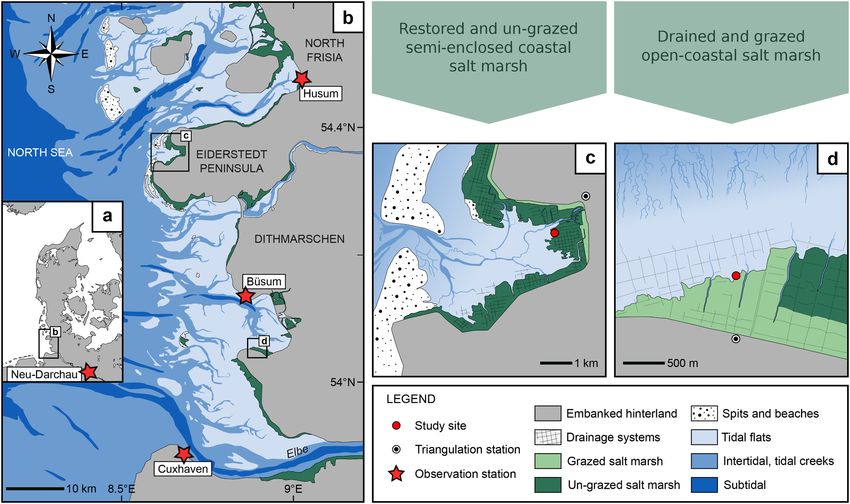
Fig. 1. South-eastern North Sea (a) and overview of the German North Sea coastline (b) with the location of the considered wind-signal stations (Husum, Büsum, and
Cuxhaven), the Cuxhaven tide gauge, and the monitoring station for Elbe River discharges at Neu-Darchau (red stars), together with the present-day regional setting
of the investigated sites at the Bay of Tümlau (c; TB13-1), and at Friedrichskoog (d; GeoHH-FK). (For interpretation of the references to colour in this figure legend,
the reader is referred to the web version of this article.)
et al. 2009; Davy et al. 2009), but they also prevent a natural landward erosional cliff face. Each U-channel has a maximum dimension of 1.75
migration of the salt marshes under rising sea level (Kirwan et al. 2016; cm width, 2.00 cm depth, and 200 cm length, and is open at one long
Müller-Navarra et al. 2019; Bunzel et al. 2020). As a consequence of the side. Cliff-surface elevation and position was surveyed by using a Leica
embankments, both salt-marsh systems are exposed to lateral erosion at Geosystems GNSS field controller (Viva Uno CS10) and referred to
the seaward side of the dike during high tides or storm tides, and thus triangulation stations number 1618 031 10 (Bay of Tümlau) and 1919
fringed by erosional cliffs between the tidal margins and the seaward 088 00 (Friedrichskoog). For further details, see Müller-Navarra et al.
edge of the marshes (Müller-Navarra et al. 2019; Bunzel et al. 2020). (2019) and Bunzel et al. (2020). Data for the triangulation stations were
These cliffs were chosen for sediment sampling, generating sediment provided by the State Office for Surveying and Geoinformation
sequences TB13-1 (Bay of Tümlau, 54◦ 21′ 51.07”N, 8◦ 40′ 35.09′′ E; Schleswig-Holstein (LVermGeo SH). Subsequent processing of the sur-
Müller-Navarra et al. 2019) and GeoHH-FK (Friedrichskoog, veyed data was conducted with the Leica Geo Office 8.3 software.
54◦ 2′ 35.02”N, 8◦ 52′ 20.41′′ E; Bunzel et al. 2020).
3. Material, methods, and data sources 3.2. Historical wind, tidal, and discharge data, and simulated water level
extremes
3.1. Field work
To assess past salt-marsh responses to natural climate variability
Field work was carried out in Dithmarschen (Friedrichskoog, site during the last century, historical wind and tide-gauge observation data,
GeoHH-FK) in November 2016, while sediments of the Eiderstedt as well as river runoff data for the Elbe River were evaluated. Since long-
peninsula (Bay of Tümlau, site TB13-01) were recovered in August 2013 term wind-observation data recorded at different signal stations along
(Müller-Navarra et al. 2019). The marsh surfaces at the erosional cliffs the German North Sea coast are often incomplete due to partly lacking
are situated 2.09 m (TB13-1) to 2.80 m (GeoHH-FK) above NHN high-resolution records, specifically during the first half of the 20th
(‘Normalhöhennull’), thus exceeding the local mean high water spring century, data of three stations near the two study sites were taken and
(MHWS) levels by 0.50 m (TB13-1) and 1.06 m (GeoHH-FK). As a result, compared, to compensate for times of sparse meteorological observa-
the investigated salt-marsh systems are only flooded during times of tions. From north to south, the stations comprise: Husum, Büsum, and
extreme water levels that are exceeding the mean high water (MHW) by Cuxhaven (Schleswig-Holstein and Lower Saxony) (Fig. 1). Data were
≥1.5 m (Gerber et al. 2016). Tidal data were provided by the Federal provided by the German Meteorological Service (DWD). In order to take
Maritime and Hydrographic Agency of Germany (BSH), and are based only severe wind conditions into account, which are directly facing the
on the nearest tide gauges Tümlauer Hafen (observation period: coastline, the daily means of winds with prevailing wind directions from
2001–2013 CE) and Friedrichskoog Hafen (observation period: ≥180◦ to 360◦ azimuth (westerly winds) and with a wind strength of ≥7
1986–2018 CE). Beaufort (Bft), that equals a minimum wind speed of 13.9–17.1 m s−1 (e.
The sediment sequences at both sites were sampled by 10–15 U- g., DWD), were used for subsequent analyses. Historical water levels are
channels, which were pressed vertically into the previously cleaned based on the tide gauge in Cuxhaven, which covers the longest time
period and provides the most complete data record for the south-eastern
3
D. Bunzel et al.                                                                                                   Global and Planetary Change 198 (2021) 103403

North Sea region (data were provided by the BSH). For subsequent an-             (HCl) Merck Suprapure. The accuracy of the method is 0.05%, based on
alyses, only tidal data with MHW ≥ 1.5 m were considered hereafter,              the averaged standard deviations of the analysed replicates after every
which is the classification of the minimum water-level height for storm          tenth sample.
tides (Gerber et al. 2016). Yearly mean discharge data of the Elbe River             In a previous study, individual age models were generated for each
were provided by the Global Runoff Data Centre (GRDC) for the moni-              sediment sequence based on the combination of different independent
toring station Neu-Darchau (Lower Saxony), which is the northern-most            dating methods commonly used to date modern sedimentary deposits
station close to the Elbe estuary (Fig. 1).                                      (Bunzel et al. 2020). This strategy enabled the establishment of an in-
    To further compare the salt-marsh sediment sequences with large-             tegrated stratigraphic framework for each site. Specifically, the down-
scale climate states, simulated extreme sea levels (ESL) and their long-         core activity of natural (210Pb) and artificial (137Cs) radionuclides,
term variability in the German Bight were considered in addition                 together with the mercury (Hg) concentration was evaluated for both
(data were provided by Lang and Mikolajewicz 2019). Extreme sea level            study sites, whereas artificial 241Am was only measured in the Bay of
indices were characterized by considering only the annual sea-level              Tümlau (Suppl. Fig. S1). Radionuclide data of TB13-1 (comprising the
maxima. The ESL setup relies on a coupled high-resolution regional at-           decay-corrected 210Pb, 137Cs, and 241Am data only; see description
mospheric model (REMO, Jacob and Podzun 1997) and a global ocean                 below) were taken from Müller-Navarra et al. (2019). Analyses for
model (MPIOM, Marsland et al. 2004; Jungclaus et al. 2013), which                GeoHH-FK were conducted with the CANBERRA’s high-purity Germa-
enables an integration of both regional and super-regional signals (for          nium detector (HPGe) with a gamma-spectrometry analysis at the Lab-
further details, see Lang and Mikolajewicz 2019).                                oratory for Radioisotopes (LARI), Georg-August-University of
                                                                                 Göttingen. Uncertainties (counting errors of 210Pb, 137Cs, and 241Am)
3.3. Sedimentological and geochemical analyses                                   were derived from the relative statistical counting error and the
                                                                                 measured activity; however, uncertainties of the unsupported 210Pb
    Grain-size measurements on the siliciclastic sediment components             were calculated by applying the Gaussian-error propagation formula on
were conducted choosing a 0.5 cm resolution for the sediment sequence            the previously obtained 210Pb counting errors. For further details, see
at site GeoHH-FK. Data for TB13-1 were provided at a 1.0 cm resolution           Bunzel et al. (2020). Furthermore, radionuclide data were corrected to
by Müller-Navarra et al. (2019). To remove the organic and inorganic             the time of sampling (decay-correction), from which the unsupported
                                                                                 210
carbon from the samples, they were treated with 10–30% H2O2 and 1 M                 Pb and 137Cs were further corrected to the sum of organic carbon and
CH3COOH successively. Subsequent grain-size measurements were                    portion of the 2.5 years only. Spectral analyses were per-
changes in the marine organic matter (MOC) supply. As Bromine is                 formed with the PAleontological STatistics (PAST) software package
comparatively sparse in terrestrial organic matter, the Br/Corg ratio was        version 4.02 (Hammer et al. 2001), using the integrated REDFIT module
then used to reflect the relative proportions of marine and terrestrial          with a Welch window (Schulz and Mudelsee 2002).
organic matter in the sediment, independent from the sediment texture
(Mayer et al. 2007; Ziegler et al. 2008). In contrast, the ln(Zr/Rb) ratio       4. Results
was used as a high-resolution proxy for the relative grain-size distribu-
tion, since Zirconium (Zr) is enriched in the coarse-grained sediment            4.1. Sediment composition and description
fraction in form of zircon, while Rubidium (Rb) is mainly concentrated
in clay minerals (e.g., Dypvik and Harris 2001; Weltje and Tjallingii               The total sediment recovery with the U-channels varied between
2008; Rothwell and Croudace 2015). Internal sedimentological down-               110 cm (TB13-1) and 116 cm (GeoHH-FK). Concerning the organic and
core characteristics were generalized and expressed as light and dark            inorganic carbon free sediment fraction, the investigated sediment se-
layers, based on previously generated optical and x-ray images (Bunzel           quences mainly consist of fine sand and silt, i.e., on average 55% sand
et al. 2020).                                                                    and 43% silt for TB13-1, and between 61% sand and 38% silt for GeoHH-
    Organic carbon (Corg) was measured by using a EuroVector                     FK. The clay content can be neglected with low values ranging between
EuroEA3000 Analyser and a measurement time of 200 s per sample.                  2% (TB13-1) and 0.5% (GeoHH-FK) on average (Fig. 2). The average
Prior to the instrumental analysis, one sediment-filled U-channel per            mean grain size is 63.33 μm for TB13-1 and 70.84 μm for GeoHH-FK
sites TB13-1 and GeoHH-FK was sampled at 1–2 cm spacing. Five mg                 (Bunzel et al. 2020). The organic carbon (Corg) content is generally
sediment material per sample were separated, subsequently freeze-                very low at both sites, showing mean values of 0.86% for TB13-1, and
dried, ground, and three times acidified with 1 M hydrochloric acid              0.57% for GeoHH-FK, however, maximum values occurred in the

                                                                             4
D. Bunzel et al. Global and Planetary Change 198 (2021) 103403
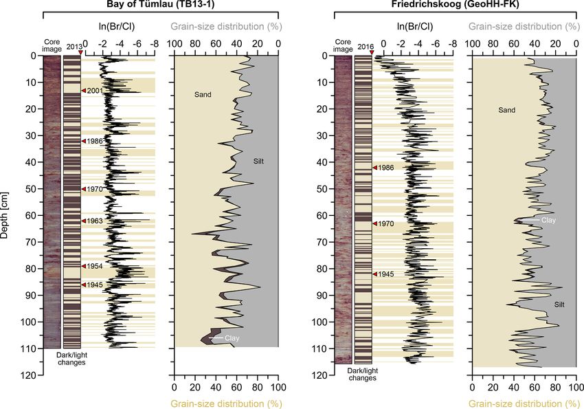
Fig. 2. Optical images of the two sediment sequences TB13-1 and GeoHH-FK together with simplified dark/light brown colour changes, representing the dark
reddish-grey to light greenish-grey sediment colours, and reliable age markers given in years CE (red triangles; Bunzel et al. 2020). Prominent drops in the ln(Br/Cl)
records are highlighted with light brown shaded bars. The relative sediment composition comprises the fractions sand (light brown), silt (grey), and clay (dark
brown); note the inversely oriented x-axes. (For interpretation of the references to colour in this figure legend, the reader is referred to the web version of this article.)
uppermost sediments. Furthermore, both sediment sequences are char- record is characterized by a prominent long-term increase towards today
acterized by a prominent horizontal lamination of alternating light (Figs. 2, 3).
(greenish-grey) and dark (reddish-grey) coloured layers (Fig. 2) (Müller- The ln(Zr/Rb) records reveal a variability on inter-decadal time-
Navarra et al. 2019; Bunzel et al. 2020). The light colour is likely caused scales with generally higher values occurring around 1930 CE (at ca. 98
by a reduced proportion of organic components being incorporated in cm depth) and between 1940 and 1950 CE (ca. 86 cm) (Suppl. Figs. S3,
the sediment matrix (Müller-Navarra et al. 2019). The thickness of the S4). From 1950 CE onwards, the decadal variability is superposed by a
individual layers in the sediment sequences ranges from around one long-term increasing trend. At site TB13-1, the ln(Zr/Rb) record exhibits
millimetre to a few centimetres, in which the layers are slightly thick- significant power (>99% χ2 confidence level) centred at periods of 65.8,
ening upward, accompanied by a gradual upward coarsening trend at 16.4, 10.1, 6.9, and 4.5 years. At site GeoHH-FK, the ln(Zr/Rb) record
both sites (Fig. 2). At site GeoHH-FK, a horizontal shell layer was shows significant power at the >99% χ2 confidence level, centred at
observed in a depth of 24 cm, which could be continuously traced along periods of 76.9 and 19.2, respectively (Fig. 3).
the entire erosional cliff face (Suppl. Fig. S2). The bottommost intervals For the total recorded time span (1914–2013 CE), the Br/Corg ratio of
at both sites were defined as reduced horizons (below ca. 100 cm at site sediments at site TB13-1 exhibits an overall increasing trend, with
TB13-1 and below ca. 110 cm at site GeoHH-FK), which are temporarily maximum values around the late 2010s (within the top 10 cm depth),
to permanently affected by ground water, revealing a dark greyish to and a transient depletion during the 1950s (ca. 80 cm) (Suppl. Figs. S3,
blackish sediment colour (Bunzel et al. 2020). S4). The Br/Corg record at GeoHH-FK partly resembles that of TB13-1,
however, with lowest values around the early 1930s (at around 90 cm
depth) and a subsequent increase, finally peaking around 1990 CE (ca.
4.2. Geochemical and spectral analyses 35 cm). After 1990 CE, the Br/Corg ratio returns to low values, similar to
those between 1930 and 1940 CE (Suppl. Figs. S3, S4).
Both ln(Br/Cl) records are characterized by strong and high-
frequency fluctuations with the recurrent occurrence of sharp drops, 5. Discussion
which can be attributed either to Bromine (Br) decreases or Chloride (Cl)
increases (Fig. 2). These drops clearly coincide with the light greenish- 5.1. Salt-marsh depositional systems and their regional variations in
grey coloured sandy sediment intervals. At site TB13-1, the distinct sediment characteristics
drops in the ln(Br/Cl) record are displaying variations on multi-decadal
to inter-decadal timescales with strong power at periods of 131.5, 21.9, The sediment sequences of the present study are generally domi-
and 12.0 years at the >99% χ2 confidence level, as well as at periods of nated by fine sand (>63 μm; on average 55% at the Bay of Tümlau and
6.6, 5.7, and 3.2 years (Fig. 3). In comparison, the ln(Br/Cl) record of 61% at Friedrichskoog) and silt (D. Bunzel et al. Global and Planetary Change 198 (2021) 103403
TB13-1 GeoHH-FK
ln(Zr/Rb) ln(Zr/Rb)
76.9 yrs
19.2 yrs
65.8 yrs
4.4 yrs
log10 power
8.5 yrs
16.4 yrs
10.1 yrs
6.9 yrs
4.5 yrs
ln(Br/Cl) ln(Br/Cl)
131.5 yrs
21.9 yrs
12.0 yrs
3.2 yrs
6.6 yrs
5.7 yrs
log10 power
Fig. 3. REDFIT power spectra with 95% and 99% red-noise confidence levels (chi2) of the ln(Zr/Rb) and ln(Br/Cl) ratios at sites TB13-1 (A, a; dark blue line) and
GeoHH-FK (B, b; light blue line), using a Welch window. Black numbers indicate periods in which the corresponding power spectra is >99% red-noise level, grey
numbers indicate periods which are significant at >95%. Shaded bands denote the relevant time intervals. (For interpretation of the references to colour in this figure
legend, the reader is referred to the web version of this article.)
Tümlau and 38% at Friedrichskoog), with rather moderate down-core surges. There, the mud of the adjacent tidal flats represents a mobile
variations (Fig. 2). The coarsening trends were observed by both the layer, which is re-suspended during the increasing shear stress of a storm
measured grain-size spectrum and the ln(Zr/Rb) ratio. In both se- event (Bartholdy and Aagaard 2001).
quences, however, changes in the sediment characteristics are indicated Correspondingly, the high-resolution ln(Br/Cl) records from the Bay
by a clearly distinct fine-scale stratification and lamination, which can of Tümlau and Friedrichskoog were used for a more detailed recon-
be attributed to the recurrent influence of the hydrodynamic interaction struction of regional storm-surge impacts and the assessment of differ-
between storm surges and tides (e.g., Reineck 1982). If, however, the ences in sediment accretion in a high-frequently dredged and grazed
allocation criteria are solely based on the grain-size spectrum of the versus a less-frequently dredged and un-grazed salt marsh. Since the
different sediment layers, storm-surge events cannot be clearly light greenish-grey coloured and more sandy sediment intervals clearly
discriminated within the studied salt-marsh deposits. In fact, sedimen- coincide with abrupt drops in the ln(Br/Cl) values (Fig. 2), this coinci-
tation dynamics in coastal salt-marsh environments are rather highly dence suggests a loss of Bromine and/or supply of Chloride during
complex. For this reason, there is often inconsistency about the char- deposition of the siliciclastic coarser-grained sediments, which may be
acteristic composition of sediment particles transported onto the salt- directly related to single storm surges (Swindles et al. 2018). In inter-
marsh surface during a storm surge. In various German, Dutch, and tidal coastal wetlands, Bromine is known to be incorporated by various
UK salt marshes, the deposition of relatively coarse-grained layers, marine primary producers such as phytoplankton, macroalgae, and
containing sand grains and/or shell fragments, have been associated seagrass, thus representing the marine organic carbon (MOC) (Mayer
with severe storm surges (e.g., Ehlers et al. 1993; de Groot et al. 2011; et al. 1981, 2007, and references therein). In addition, Bromine can
Schuerch et al. 2012; Swindles et al. 2018). In contrast, Eisma and Irion indicate high sediment porosity accompanied by a high seawater con-
(1988) and Bartholdy (2000) related the deposition of fine-grained tent in the pore spaces (Thomson et al. 2006; Ziegler et al. 2008). In
material (D. Bunzel et al. Global and Planetary Change 198 (2021) 103403
pore water (Thomson et al. 2006), remaining almost constant with since the salt-marsh surface at Friedrichskoog is much higher with 2.80
increasing sediment depth (Beck et al. 2008). Consequently, the ln(Br/ m NHN, and at this more wave-exposed open coastal site the general net
Cl) ratio can provide information about changes in the marine organic transport and deposition of re-suspended sediments during storm surges
matter supply. An enhanced transport of re-suspended material from the should be expected to be higher than in the semi-enclosed salt marsh in
surrounding tidal flats during a storm-surge event (e.g., Eisma and Irion the Bay of Tümlau. Apparently, the contrasting accretion rates can be
1988), may then result in a concomitant increase of the MOC deposition partly attributed to the different anthropogenic land-use histories,
on the adjacent salt marshes. However, North Sea ecosystems are including the establishment of different vegetation types. Particularly,
characterized by strong seasonal contrasts in primary production and interventions by intense grazing management affect the heterogeneity of
storm surge induced suspension, with maximum production rates during the salt-marsh plant communities (Bakker et al. 2019). Consequently, a
spring and summer, but maximum re-suspension of the sediment par- monotonous short-grazed sward cover (mainly consisting of Puccinellia
ticles during winter (Skogen et al. 1995). These seasonally differing maritima), as it is found at Friedrichskoog, can diminish the process of
impacts seems to be archived by the stratified salt-marsh sequences, capturing suspended sediments from incoming waves during submer-
which show regular alternations between clayey-silty (dark reddish-grey gence (Kiehl et al. 1996; Nolte et al. 2013). In comparison, the devel-
coloured) and silty-sandy (light greenish-grey coloured) sediment layers opment of a more natural vegetation in the Bay of Tümlau enhanced the
across the depths. Accordingly, the stratification presumably reflects the accretion rate of sediment particles during storm surges (Schuerch et al.
different influences of storm surge-induced sediment accretion (Redfield 2012; Möller et al. 2014; Leonardi et al. 2018; Müller-Navarra et al.
1972; Behre and Streif 1980; Ehlers et al. 1993; Chaumillon et al. 2017), 2019). However, due to the semi-enclosed position of the bay, storm-
in dependence of that times at which the suspended material of the surge waves are attenuated and sediment deposition on the salt marsh
water columns contains more MOC and finer-grained sediments, occurs under relatively low-energy conditions (Müller-Navarra et al.
respectively, less MOC and coarser-grained sediments (e.g., Bartholdy 2019). This is underlined by the absence of shell fragments within the
and Anthony 1998). Based on these observations, the abrupt drops in the potential silty-sandy storm layers, but the occurrence of allochthonous
ln(Br/Cl) records in connection with the light greenish-grey coloured calcareous foraminiferal tests originating from the surrounding tidal
and more silty-sandy sediment intervals, particularly evident flats (Müller-Navarra et al. 2019). This finding is in accordance with
throughout the sediment sequence at the Bay of Tümlau, likely represent results from sheltered Dutch salt marshes, where the deposition of sed-
deposits evoked by regional storm surges in winter time. During winter, iments was associated with low-energy conditions of tides and waves (de
the MOC content of the total suspended matter is ≤20% (Eisma and Irion Jong et al. 1994). Further, the estimated accretion rates at the Bay of
1988), and the high sedimentary pore volume in the sand layers pro- Tümlau slightly decreased in recent times, which implies a naturally
motes an enrichment of Chloride (Thomson et al. 2006). Hence, pro- advanced stage of maturity of the local marsh system. In contrast, the
nounced drops in the ln(Br/Cl) ratio further represent the dilution of the potential storm layers deposited at Friedrichskoog contain compara-
re-suspended MOC by the concomitant high proportion of siliciclastic tively more coarse particles, occasionally even larger shell fragments.
coarser-textured particles. Conversely, clayey-silty intervals revealing This suggests an exposition of the studied salt-marsh sequence to rather
comparably higher ln(Br/Cl) values may then represent re-suspension in high-energy conditions during a storm surge. Nevertheless, the overall
spring to fall under generally calm weather conditions with less intense sediment-accretion rate is lower at Friedrichskoog due to the combined
storms, when the suspended material encompasses highest MOC con- effects of an altered vegetation by grazing, and a rather flat salt-marsh
tents together with finer-grained particles. This is in line with studies by morphology, which is at the same time artificially elevated due to the
Bartholdy and Anthony (1998), who documented the highest import of intense dredging and drainage measures (e.g., de Jong et al. 1994;
fine-grained sediments from the open North Sea to the Wadden Sea coast Müller-Navarra et al. 2016).
at times of fair weather conditions.
At Friedrichskoog, the observed small-scale variability in the ln(Br/ 5.2. Salt-marsh archive of changes in storminess and regional sea level
Cl) ratio is less pronounced and rather superposed by the overall
increasing values towards the sediment surface. Inspection of the XRF The effects of changing extreme water levels on salt-marsh deposi-
raw data reveals that this long-term ln(Br/Cl) increase is mainly caused tional processes were further evaluated by considering the sedimentary
by a concomitant decrease of the Chloride counts. Since the salt-marsh Br/Corg ratio. The similar appearing long-term trends in both Br/Corg
surface at Friedrichskoog is situated 2.80 m above NHN (1.06 m records from the Bay of Tümlau and Friedrichskoog reveal lowest Br/
above mean high water spring, MHWS), while the salt marsh in the Bay Corg values during the first half of the 20th century, suggesting that the
of Tümlau is situated only 2.09 m above NHN (0.50 m above MHWS), marine influence was likewise comparatively low during this time.
the seawater induced Chloride supply likely decreased with increasing Whereas, the subsequent increase in Br/Corg values from the mid-
height of the salt-marsh surface at Friedrichskoog. This would be century towards recent times, with highest values occurring between
compatible with a long-term decrease in submergence time and fre- 1990 CE (Friedrichskoog) and 2010 CE (Bay of Tümlau), reflect an in-
quency responding to the gradual elevation of the salt-marsh surface at crease in the marine contribution towards recent times (Fig. 4b, d) (e.g.,
Friedrichskoog during recent times. There, the increase in surface level Mayer et al. 1981). Consequently, both Br/Corg records are resembling
was probably artificially promoted by the frequent dredging measures. the trends in North Sea storminess, which is reflected by the historical
As a consequence, the top soils at the more elevated erosional cliff wind observation and tide-gauge data at Husum, Büsum, and Cuxhaven
became partly dehydrated (e.g., de Jong et al. 1994). In contrast, the showing a gradual amplification in the wind strength and water-level
more sheltered location of the lower salt marshes in the Bay of Tümlau height around 1920 CE and towards the 1990s (Fig. 4). In fact, North
favoured a more sensitive and persistent response of short-term depo- Sea storminess varies on timescales of decades and longer, in which
sitional processes to seasonal changes in storminess. At this site, the periods of enhanced storminess mainly coincide with the beginning and
response of the salt-marsh system to regional climate variability was the end of the 20th century, while a period of reduced storminess occurs
further enhanced by a return of natural conditions when grazing and during the mid-century centred around 1960 CE (Matulla et al. 2008;
draining was persistently stopped after National Park foundation Weisse et al. 2012; Dangendorf et al. 2014). It remains unclear, however,
(Müller-Navarra et al. 2019). why the highest Br/Corg values at the different sites appear with an offset
When further taking the obtained mean accretion rates into consid- of about 20 years, i.e., 20 years earlier at Friedrichskoog (1990 CE) than
eration, slightly lower average accretion rates (1.16 cm yr−1) appeared in the Bay of Tümlau (2010 CE). These contrasts may likewise reflect the
in the grazed and ditched salt marsh at Friedrichskoog when comparing land-use histories of the two salt marshes with differences in
to the less modified and more naturally developed salt marsh in the Bay morphology, elevation, and corresponding vegetation communities
of Tümlau (1.31 cm yr−1) (Bunzel et al. 2020). This result is surprising affecting the local submergence frequencies. Furthermore, the different
7D. Bunzel et al. Global and Planetary Change 198 (2021) 103403
Intensification of coastal defense measures
iness
sin g storm
b Increa
Annual max. sea level [m] 5pma
c ESL
d
Fig. 4. Distribution patterns of the ln(Zr/Rb) ratios as a proxy for grain-size fluctuations at the Bay of Tümlau (TB13-1; dark blue) and Friedrichskoog (GeoHH-FK;
light blue) (a), and Br/Corg ratios as indicator for changes in the marine organic matter supply (b). (c): Simulated times series of extreme sea levels (ESL) at Cuxhaven;
data were provided by Lang and Mikolajewicz (2019). (d): Yearly number of recorded storm-surge days, which are exceeding the mean high water (MHW) with ≥1.5
m at the Cuxhaven tide gauge (light blue-green), and number of days with westerly winds exceeding ≥7 Beaufort (Bft) at Husum (yellow circles), Büsum (white
circles), and Cuxhaven (red circles). The grey band marks the period of general amplified storm-climate conditions and concomitant increased flooding of the salt
marshes. Dark green bars at the top show observed Elbe River discharges at Neu-Darchau, when the annual mean discharges are exceeding the total mean discharges
of 700 m3 s−1. 5pma = 5-point moving average. (For interpretation of the references to colour in this figure legend, the reader is referred to the web version of
this article.)
and highly dynamic depositional environments at the North Sea coast depositional conditions (e.g., Allen 1989; Ehlers et al. 1993).
may, most likely, account for ageing uncertainties within the salt-marsh The modern extreme water levels, and associated risks by flooding,
stratigraphy, although the obtained age models appear relatively robust started to increase from the mid-20th century onwards, outpacing the
for the past ~70 years (Bunzel et al. 2020). Moreover, both Br/Corg re- rate of regional sea-level rise (SLR) (e.g., Mudersbach et al. 2013; Arns
cords imply a storminess strengthening already starting in the first half et al. 2017). The reason is that mean sea level (MSL) and extreme sea
of the 20th century, while the increasing coarsening of the sediments (as levels rather seem to represent a non-linear feedback, i.e., a regional
suggested by the ln(Zr/Rb) ratio) started to be decoupled from the long-term MSL rise does not necessarily result in a comparable linear rise
previously prevailing inter-decadal variability since around 1950 CE, in extreme high-water levels (e.g., Dangendorf et al. 2013b; Mudersbach
which is in line with model simulations (e.g., Matulla et al. 2008). et al. 2013; Arns et al. 2015; and references therein). Indeed, the climate
However, the upward coarsening trends at both sites reflect rather mechanisms being responsible for variations in the extreme water level
indirectly the increase in marine influences, as the seaward edges of the and accompanied flooding likely differ from those causing background
salt marshes are progressively under erosion when sea level rises, sea-level variations (Lang and Mikolajewicz 2019). Consequently, the
leading to a retreat of the marsh-edge cliffs and increasingly proximal North Sea storminess itself lacks a clear long-term trend (Weisse et al.
8D. Bunzel et al. Global and Planetary Change 198 (2021) 103403
2012), as it was observed for the MSL (2.4 ± 0.1 mm yr−1; Dangendorf Regional environmental responses to interfering climate modes were
et al. 2013a). further postulated by Ionita et al. (2011) and Zanchettin et al. (2019),
Commonly, shallow coastal environments are considered extremely who documented periodic inter-decadal fluctuations in the discharge of
vulnerable to the impacts of an accelerating SLR and possible changes in the Elbe River, centred at a period of 14.2 years. As discussed above,
storminess (Dangendorf et al. 2013b; Arns et al. 2017). Assuming a salt-marsh sediments along the south-eastern North Sea coast mainly
maximum SLR scenario of 84 cm by 2100 CE (IPCC, 2019), up to 45% of originate from the surrounded tidal flats and/or adjacent eroded salt
the salt-marsh areas may vanish, at least along the south-eastern U.S. marshes (Schuerch et al. 2019), in which the prevailing anti-clockwise
coast (Craft et al. 2009). Although those salt-marsh areas that receive sea-surface circulation and tidal currents are responsible for the
high amounts of minerogenic sediment supplies may compensate for the required erosion, transportation, and deposition of the sediments
SLR-evoked loss of coastal wetland habitats (French 2006; Stevenson (Postma 1981; Eisma and Kalf 1987; Eisma and Irion 1988; Winther and
and Kearney 2009). Accordingly, the recorded sediment-accretion rates Johannessen 2006). Additionally, around 4.8 × 10⁶ t yr−1 of suspended
of 1.16–1.31 cm yr−1 in Friedrichskoog and the Bay of Tümlau suggest particulate matter are remobilized by the rivers and transported into the
that the different salt-marsh systems at the south-eastern North Sea coast North Sea basin (Eisma and Kalf 1987; Eisma and Irion 1988; Allen
are currently able to outpace the ongoing SLR, as long as the required 1990; Wolfstein and Kies 1999). Based on that, the sediment sequence at
sediment import and flooding dynamics are ensured (Bunzel et al. Friedrichskoog is likely affected by both tidal currents and the Elbe River
2020). In addition to the direct consequences of climate-induced SLR discharge, due to its exposed location in an open coastal salt-marsh
and concomitant differences between MSL and extreme sea levels, setting and its proximity to the Elbe Estuary (Bunzel et al. 2020). In
coastal protection measures may have also contributed to a change in contrast, the more sheltered salt marsh in the Bay of Tümlau located
the storm-surge signal (Dangendorf et al. 2013b). Since there was no further north is expected to be less influenced by the latter, although its
need to maintain the heights and efficiency of dikes between 1855 and ln(Zr/Rb) record is similar to that at Friedrichskoog. Accordingly, high
1962 CE, due to the period of reduced storminess, the severe storm-surge ln(Zr/Rb) values may at least partly reflect the enhanced availability of
event in 1962 CE caused many dike failures, and thus a wide range of suspended material in the Wadden Sea during times of high river dis-
damages and casualties along the German North Sea coast (von Storch charges, that are alternating on similar inter-decadal timescales.
et al. 2008). As a consequence, extensive investments were subsequently Changes in the atmosphere-ocean climate oscillation over the North
initiated to improve coastal protection measures, i.a., by improving the Atlantic and Europe are further generating shifts in the wind speed and
dike bases and rising the dike levels up to 7.20 m above NHN, entailing direction, and corresponding MSL (e.g., Wahl et al. 2011; Dangendorf
persistent ecological and morphological impacts on the coastal ecosys- et al. 2013a), which may also have contributed to the observed changes
tems (Kelletat 1992; von Storch et al. 2008; Dangendorf et al. 2013b). on inter-decadal timescales in both ln(Zr/Rb) records (Fig. 4a). Specif-
Hence, the establishment and observed retreat of the erosional salt- ically, dipole anomalies towards a positive NAO phase are associated
marsh cliffs and accompanied coarsening trends, as mentioned above, with recurrent north-westerly winds and extreme sea-level high-stands
likely have been further accelerated due to intensified coastal protection in the German Bight (Lang and Mikolajewicz 2019). These conditions
measures, as the dikes in the hinterland prevent a landward migration of may have fostered the deposition of coarser textured particles in the salt
the salt marshes with SLR. marshes under high-energy conditions. The observed long-term increase
of both ln(Zr/Rb) records and sand contents since 1950 CE onwards
5.3. North Atlantic climate control on salt-marsh sedimentation in the (Fig. 4a), which is partly superimposed on the decadal trends, corre-
German Bight sponds to the concomitant increase in North Sea storminess (Fig. 4d),
and is also reflected by the gradual Br/Corg increase (Fig. 4b). Appar-
The investigated sediment archives cover approximately the last 100 ently, the ln(Zr/Rb) and Br/Corg records specifically reflect the period of
years. A similar long-term variability in both ln(Zr/Rb) records suggest strengthened North Sea storminess since the mid-1950s towards recent
comparable depositional processes in the Bay of Tümlau (TB13-1) and times, when the long-term increase in rates of extreme water levels is
Friedrichskoog (GeoHH-FK), although the different exposures and land- decoupled from the MSL, as related to changes in the tidal regime
use histories account for site-specific differences. The relative alterna- (Mudersbach et al. 2013; Arns et al. 2015, 2017). While a direct com-
tion of coarser- and finer-grained material on inter-decadal timescales, i. parison between individual recorded storm surges, extreme sea-level
e., at periods of 10.1 and 16.4 years (TB13-1), and 19.2 years (GeoHH- simulations from model experiments (Lang and Mikolajewicz 2019;
FK), is particularly pronounced during the early 20th century until 1950 Fig. 4c), and sedimentary proxy records may reveal inconsistencies,
CE (Fig. 4). In comparison, the ln(Br/Cl) record of site TB13-1 exhibits their long-term trends show similar variations on various timescales
similar variability with significant periods centred at 12.0–21.9 years, (Fig. 4), as described above. Accordingly, salt-marsh deposition along
while site GeoHH-FK lacks comparable periodicities at the >99% con- the south-eastern North Sea is likely driven by interfering large-scale
fidence level (Fig. 3). Hence, the observed periodicities of the ln(Zr/Rb) climate variabilities and the combined effects of storminess and Elbe
and ln(Br/Cl) records suggest a close linkage of sediment accretion, River discharge, and associated suspended matter availability.
changes in flooding dynamics, and related shifts in the primary pro- In the ln(Zr/Rb) record originating from the Bay of Tümlau, strong
duction to super-regional oscillations in the atmosphere-ocean system. spectral power was further observed for a period of 65.8 years, as well as
One of the major modes, forcing a recurrent atmospheric circulation for a period of 76.9 at Friedrichskoog. Despite the comparatively low
pattern in the Northern Hemisphere, is the North Atlantic Oscillation statistical significance of these long periodicities, they may reflect a
(NAO) (Hurrell 1995; Hurrell et al. 2003), which exhibits an 11–25 year relation of sedimentation processes to the Altantic Multidecadal Oscil-
period related to the solar Hale cycles (Fairbridge and Krebs, 1961; lation (AMO), coinciding with changes in the North Atlantic sea-surface
Raspopov et al. 2004). The NAO dipole anomalies between the Arctic temperature (SST) on periods of 50–90 years (Enfield and Cid-Serrano
and subtropical Atlantic are responsible for a variety of climate changes 2010). Accordingly, the complex interaction of NAO and AMO and su-
concerning wind speed and direction, precipitation, and temperature perposition of various periodicities in driving European hydroclimate (e.
(Hurrell 1995; Hurrell et al. 2003; Wakelin et al. 2003; Ionita et al. g., Enfield et al. 2001; Sutton and Dong 2012; Zanchettin et al. 2019),
2011). The occurrence of oscillating climate patterns on inter- to multi- may account for a comparable long-term periodicity archived by sedi-
decadal timescales is, however, often discussed as being the result of ments of salt marshes in the Bay of Tümlau and Friedrichskoog. How-
various interfering climatic teleconnections (e.g., Comas-Bru and ever, any long-term fluctuations cannot be confidently proven, as data of
McDermott 2014). Consequently, the observed periodic changes in salt- the corresponding sediment sequences are limited by covering only the
marsh sedimentation dynamics may be likewise the product of inter- last ca. 100 years.
fering decadal-scale shifts in the climate system. Variability on shorter timescales, comprising significant periods
9D. Bunzel et al. Global and Planetary Change 198 (2021) 103403
between 3.2 and 6.9 years (>χ2 99%), as documented by the ln(Br/Cl) ratios started to increase from the mid-20th century towards
and ln(Zr/Rb) records in the Bay of Tümlau, and periods with compar- recent times, with highest values occurring between 1990 and
atively weak power (>χ2 95%) between 4.4 and 8.5 years at Frie- 2010 CE. This trend is accompanied by a concurrent increase of
drichskoog (Fig. 3), cannot be clearly linked to any climate modes the ln(Zr/Rb) ratios, resembling the period of strengthened North
either, as they are likely impacted by coastal management activities. Sea storminess since the mid-1950s onwards, when the long-term
Specifically, these small-scale changes may be attributed to human- increase in rates of extreme water levels is decoupled from the
induced dredging activities, in which the drainage systems are recur- MSL. The general coarsening-upward trends in the ln(Zr/Rb)
rently renewed by removing the previously accumulated sediments from ratios can then be attributed to the combined effects of the
the drainage trenches and by replacing the material onto the sur- retreating erosional cliff face, increasing flooding frequency due
rounding salt-marsh surfaces (Nolte et al. 2013; Müller-Navarra et al. to enhanced storminess, but also intensified coastal protection
2019; Bunzel et al. 2020). Close to the Elbe estuary, these measures are measures.
carried out every two to three years, while the time intervals for (3) The salt-marsh successions reflect changes in the regional storm
dredging activities are increased further north (every three to seven climate, revealed by the ln(Zr/Rb) records alternating on inter-
years). This strategy considers the northward decrease in the amount of decadal (10–19 years) timescales at both study sites. In compar-
suspended particles in the water column, leading to a reduction of ison, the ln(Br/Cl) record from the Bay of Tümlau varies on
accumulated sediments in the drainage trenches of salt marshes in the timescales of 12–22 years, while similar periodicities are lacking
North (pers. comm. Schleswig-Holstein Agency for Coastal Defence, at Friedrichskoog. These periodicities suggest a close linkage of
National Park and Marine Conservation, LKN.SH, 2017, 2020). This the North Sea storminess and associated shifts in the primary
management strategy was carried out in most salt-marsh systems of the production to oscillations in the atmosphere-ocean system. The
south-eastern North Sea, before it was successively abandoned with corresponding large-scale atmospheric circulation anomalies are
establishment of the Wadden Sea National Park in 1985 CE in many the main drivers of the European hydroclimate, generating
areas, including the Bay of Tümlau (Nolte et al. 2013; Müller-Navarra (multi-) decadal variability of precipitation and related river
et al. 2019). Nowadays, these dredging activities are mainly restricted to runoff, westerly winds and extreme water levels in the German
salt-marshes, which are still grazed, such as Friedrichskoog, accounting Bight. Apparently, the salt-marsh depositional systems in the
for the observed differences in the disturbance of the sediment sheltered Bay of Tümlau responded particularly sensitive to
sequences. super-regional climatic impacts.
6. Conclusions Declaration of Competing Interest
High-resolution geochemical and sedimentological proxy records The authors declare that they have no known competing financial
from two different salt marshes of the south-eastern German North Sea interests or personal relationships that could have appeared to influence
coast document variations in regional storm-climate conditions and the work reported in this paper.
potential links to North Atlantic climate conditions during the past The authors declare the following financial interests/personal re-
century. The studied salt marshes include the more naturally developed lationships which may be considered as potential competing interests:
salt marsh at the Bay of Tümlau and the intensely anthropogenically
modified salt marsh at Friedrichskoog. Despite different human man- Acknowledgements
agement histories of ditching and grazing, storm-surge signals are
archived in the sediment archive of both studied salt marshes. The main This study was conducted within the research project SEASTORM,
conclusions of this study are summarized below: which is part of the Priority Program (SPP-1889) ‘Regional Sea Level
Change and Society (SeaLevel)’. Financial support was provided by
(1) Contrasting sediment-accretion rates in the Bay of Tümlau and grants SCHM1180/19 and MI1508/4 from the German Research Foun-
Friedrichskoog reflect different anthropogenic land-use histories, dation (Deutsche Forschungsgemeinschaft, DFG). We acknowledge the
which are accompanied by the establishment of deviating vege- State Office for Surveying and Geoinformation Schleswig-Holstein
tation types. The less modified and more naturally developed salt- (Landesamt für Vermessung und Geoinformation Schleswig-Holstein,
marsh vegetation in the Bay of Tümlau fostered sediment accu- LVermGeo SH) for providing information of the trigonometric points,
mulation during storm surges, although the deposition on the salt the German Meteorological Service (Deutscher Wetterdienst, DWD) for
marsh occurs under relatively low-energy conditions within the delivering historical wind-observation data, and the Federal Maritime
semi-enclosed position of the bay. In contrast, at the more wave- and Hydrographic Agency of Germany (Bundesamt für Seeschifffahrt
exposed open coastal salt marsh at Friedrichskoog, the deposited und Hydrographie, BSH) for providing tide-gauge data of the German
storm layers contain coarser particles, however, the overall North Sea coast. The Global Runoff Data Centre (GRDC) is thanked for
sediment-accretion rate is lower due to the altered vegetation by providing Elbe River discharge data. Christian Wiedemann and Martin
grazing. Stock, National Park of the Schleswig-Holstein Wadden Sea (Natio-
Pronounced drops in the ln(Br/Cl) records together with the nalpark Schleswig-Holsteinisches Wattenmeer), are thanked for
occurrence of sandy sediment layers are likely owed by storm providing permissions to work in the restored salt marshes. The manu-
surges in winter, when extreme water levels and subsequent script profited from the comments and suggestions of two anonymous
inland propagating storm waves are more frequent and intense. reviewers. Andreas Lang and Uwe Mikolajewicz are thanked for
The associated suspended material contains less marine organic providing simulated extreme sea-level data of the German Bight and for
carbon (MOC), and the enhanced sediment porosity in the sand many discussions. We also thank Jutta Richarz, Sascha Plewe and Niko
layers allows for an enrichment of Chloride. Hence, variations in Lahajnar for technical support during XRF scanning and laboratory
the ln(Br/Cl) ratio are interpreted to reflect the seasonal differ- analyses. Bastian Vennemann and Pavel Reich developed the Python
ences in the effects of storm surges, but the specific exposure and scripts and R packages to manage the large amounts of historical wind
land-use history of a salt-marsh system determines how well the and tide-gauge data.
signal is archived in the deposited sediments.
(2) Both salt-marsh sequences exhibit lowest Br/Corg values during Appendix A. Supplementary data
the first half of the 20th century, suggesting that the marine in-
fluence was comparatively low during this time. The Br/Corg Supplementary data to this article can be found online at https://doi.
10You can also read