Numerical modeling of the Cenozoic geomorphic evolution of the southern Sierra Nevada, California
←
→
Page content transcription
If your browser does not render page correctly, please read the page content below
Earth and Planetary Science Letters 259 (2007) 85 – 96
                                                                                                             www.elsevier.com/locate/epsl

        Numerical modeling of the Cenozoic geomorphic evolution
                of the southern Sierra Nevada, California
                                                          Jon D. Pelletier
   Department of Geosciences, University of Arizona, Gould-Simpson Building, 1040 East Fourth Street, Tucson, Arizona 85721-0077, USA
                        Received 13 February 2007; received in revised form 23 April 2007; accepted 23 April 2007
                                                     Available online 27 April 2007
                                                          Editor: M.L. Delaney

Abstract

    Recent geomorphic studies suggest that significant (∼ 1.5 km) late Cenozoic surface uplift occurred in the southern Sierra
Nevada, a conclusion that is difficult to reconcile with recent stable-isotopic paleoaltimetry studies. Numerical modeling can play
an important role in resolving this dispute. In this paper I use two models of bedrock channel erosion, the stream-power model and
a sediment-flux-driven model, to test hypotheses for the fluvial Cenozoic geomorphic evolution and surface uplift history of the
southern Sierra Nevada. Cosmogenic data for upland erosion and river incision rates allow each model parameter to be uniquely
constrained. Numerical experiments using the sediment-flux-driven model suggest that the modern southern Sierra Nevada was
constructed from a 1.0-km pulse of range-wide surface uplift in the latest Cretaceous (∼60 Ma) and a 0.5-km pulse in the late
Miocene (∼ 10 Ma). The persistent geomorphic response to latest Cretaceous uplift in this model is the result of limited “cutting
tools” supplied from the upland low-relief Boreal Plateau. This uplift history correctly predicts the modern topography of the range,
including the approximate elevations and extents of the Chagoopa and Boreal Plateaux and their associated river knickpoints.
Numerical experiments using the stream-power model are most consistent with a 1-km pulse of uplift in the late Eocene (∼ 30 Ma)
and a 0.5-km pulse in the late Miocene (∼ 7 Ma). Both models suggest that the remaining rock uplift required to produce the 4-km
peak elevations of the modern southern Sierra Nevada was produced by flexural-isostatic uplift in response to river incision. The
balance of evidence, including the dominance of sediment-flux-driven erosion in granitic rocks, previous paleoaltimetry studies,
and the timing of sediment accumulation in the Great Valley, support the conclusions of the sediment-flux-driven model, i.e. that
the Sierra Nevada experienced range-wide surface uplift events in the latest Cretaceous and late Miocene. More broadly, these
results indicate that nonequilibrium landscapes can persist for long periods of geologic time, and hence low-relief upland
landscapes do not necessarily indicate late Cenozoic surface uplift.
© 2007 Elsevier B.V. All rights reserved.

Keywords: Sierra Nevada; paleoaltimetry; bedrock channel erosion; numerical modeling

1. Introduction                                                            Poage and Chamberlain, 2002; Clark et al., 2005b;
                                                                           Mulch et al., 2006), the Himalaya and southern Tibet
   In the past few years, stable-isotopic and geomorphic                   (e.g. Clark et al., 2005a, 2006; Currie et al., 2005; Grujic
approaches have been used to infer the Cenozoic surface                    et al., 2006), and the central Andes (e.g. Ghosh et al.,
uplift history of the Sierra Nevada of California (e.g.                    2006; Barke and Lamb, 2006). In some cases, strong
                                                                           arguments exist both for and against late Cenozoic
   E-mail address: jdpellet@email.arizona.edu.                             surface uplift for a particular region. In the Sierra
0012-821X/$ - see front matter © 2007 Elsevier B.V. All rights reserved.
doi:10.1016/j.epsl.2007.04.030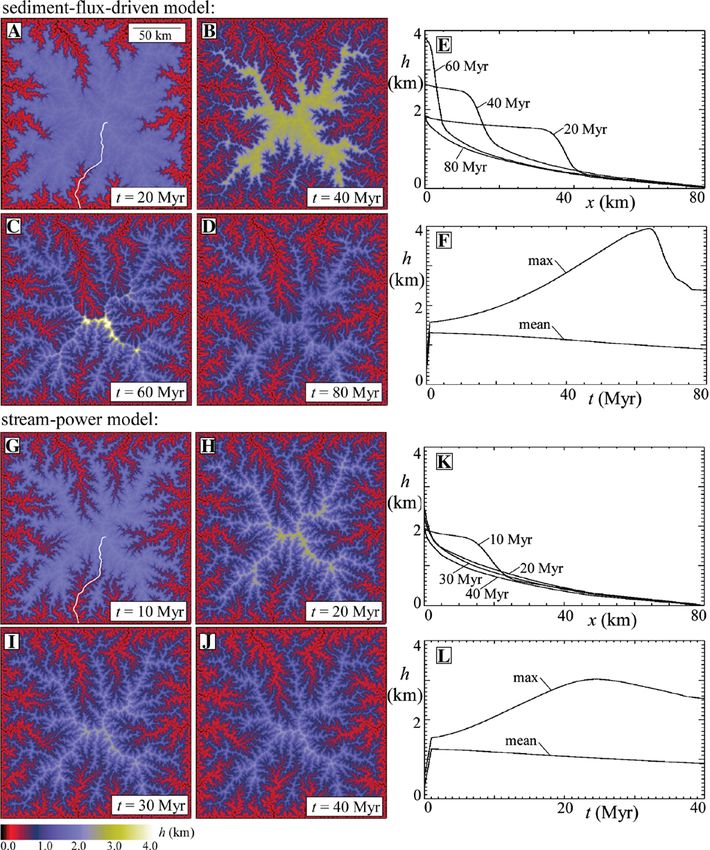
86                             J.D. Pelletier / Earth and Planetary Science Letters 259 (2007) 85–96

Nevada, for example, the presence of a slowly eroding                triggers knickpoint retreat along mainsteam rivers, but
plateau perched 1.5 km above narrow river canyons                    the time lag between incision at the range front and
suggests late Cenozoic surface uplift of ∼ 1.5 km in the             incision tens of kilometers upstream is not well
southern part of that range (Clark et al., 2005b). Stable-           constrained. Thermochronologic data have been col-
isotope paleoaltimetry of Eocene gravels (Mulch et al.,              lected from many sites (e.g. House et al., 1997, 1998,
2006), however, imply that the northern Sierra Nevada                2001; Clark et al., 2005b; Cecil et al., 2006), but the
achieved an elevation of at least 2.2 km by Eocene time.             westernmost samples are located approximately 30 km
These results are not necessarily contradictory since                from the range front. In the southern part of the range,
they represent different parts of the range, but they                these data provide a 32 Ma maximum age for the onset
require distinctly different Cenozoic surface uplift                 of stream incision at sample localities. Range-wide
histories in the northern and southern Sierra Nevada in              surface uplift could have occurred significantly earlier
order to be reconciled.                                              than 32 Ma, however, given the time that may have been
    Three additional lines of geomorphic evidence                    required for knickpoints initiated at the range front to
suggest that significant late Cenozoic rock uplift occurred          propagate 30 km or more upstream. Knickpoint retreat
throughout the Sierra Nevada, bolstering the claim for               rates of 1 m/kyr, for example, would result in a 30 Myr
widespread late Cenozoic surface uplift. Unruh (1991)                time lag between range-wide surface uplift and knick-
documented 1.4° of post-late-Miocene westward tilting                point passage at westernmost sample localities. Second,
of the northern Sierra Nevada based on the stratigraphy of           rock uplift, stream-incision, and local surface uplift can
the Great Valley. Huber (1981, 1990) documented                      all occur in the absence of range-wide surface uplift. As
approximately 700 m of stream incision/rock uplift                   stream incision removes topographic loads from the
along the mainstem San Joaquin and Tuolumne drainages                crust, for example, isostatic rebound raises slowly
(southern and central Sierra Nevada) since 10 Ma.                    eroding upland plateau remnants to elevations much
Wakabayashi and Sawyer (2001) extended Huber's work                  higher than the original, regionally extensive surface. As
to drainages in the northern Sierra Nevada, documenting              such, no simple relationship exists between the timing of
as much as 1 km of late Cenozoic (b10 Ma) incision but               local surface uplift and range-wide surface uplift.
limited Eocene–Miocene incision in drainage head-                        The goal of this paper is to evaluate hypotheses for
waters. These authors argued that stream incision and                range-wide surface uplift of the southern Sierra Nevada
surface uplift are equivalent near the crest of the range            and to refine our understanding of the spatial and
because of the low cosmogenic erosion rates measured                 temporal distribution of uplift and erosion using
there (i.e. ∼0.01 mm/yr). Stock et al. (2004, 2005) dated            numerical landscape evolution modeling. This paper
cave sediments cosmogenically to document a pulse of                 focuses on the southern Sierra Nevada because of the
relatively high channel incision rates (∼0.3 mm/yr)                  limited impact of Plio-Quaternary glaciation in valleys
between 1.5 and 3 Ma in the South Fork Kings River and               of this part of the range (Clark et al., 2005b).
nearby drainages of the southern Sierra Nevada. The                  Cosmogenic erosion rate studies provide key constraints
broad geographic range of these studies clearly indicates            on numerical model parameters, enabling the relation-
that significant late Cenozoic rock uplift occurred                  ship between specific uplift histories and the topo-
throughout the range. Similarity in the large-scale                  graphic evolution of the range to be uniquely
topographic form of the northern and southern Sierra                 determined, including the effects of transient knickpoint
Nevada (i.e. both have asymmetric profiles with steep                migration and flexural-isostatic response to erosion. In
eastern escarpments and gently dipping western slopes),              the next section I review key aspects of the geomor-
as well as similar Cenozoic exhumation rates (Cecil et al.,          phology and geochronology of the southern Sierra
2006), suggest that the northern and southern Sierra                 Nevada that provide calibration or validation data for the
Nevada may have undergone similar surface uplift                     numerical model.
histories. Nevertheless, the northern and southern parts
of the range have significant structural differences: the            2. Geomorphology and rates of landscape evolution
northern Sierra Nevada is a west-dipping tilt block, while           in the Sierra Nevada
deformation within the southern Sierra Nevada is
accommodated on a series of normal faults (Clark et                      Two distinct topographic surfaces have long been
al., 2005b).                                                         recognized in the southern Sierra Nevada (Webb, 1946)
    Despite extensive research, the relationship between             (Fig. 1). The Boreal Plateau is a high-elevation, low-
rock uplift and surface uplift in the Sierra Nevada                  relief surface that dips to the west at 1° (Fig. 1B). The
remains uncertain for two reasons. First, surface uplift             Chagoopa Plateau is an intermediate “bench” surface,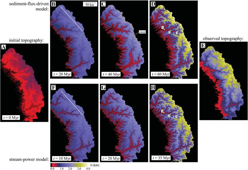
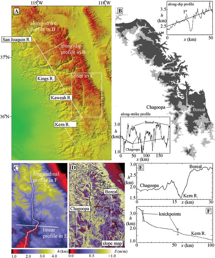
J.D. Pelletier / Earth and Planetary Science Letters 259 (2007) 85–96                                             87

Fig. 1. Major geomorphic features of the southern Sierra Nevada. (A) Shaded relief map of topography indicating major rivers and locations of
transects plotted in B. (B) Maximum extents of the Chagoopa and Boreal Plateaux based on elevation ranges of 1750–2250 m and 2250–3500 m a.s.l.
Also shown are along-strike and along-dip topographic transects illustrating the three levels of the range in the along-strike profile (i.e. incised gorges,
Chagoopa and Boreal Plateaux) and the westward tilt of the Boreal Plateau in the along-strike transect. (C)–(D) Color map of topography (C) and
slope (D) of the North Fork Kern River, illustrating the plateau surfaces (E) and their associated river knickpoints (F).

restricted to the major river canyons, inset into the                            landscape that was uplifted to its current elevation in two
Boreal Plateau (Webb, 1946; Jones, 1987). Associated                             pulses after 32 and 3.5 Ma. In their model, late Cenozoic
with each surface are prominent knickpoints along                                (b 32 Ma) surface uplift of ∼1.5 km initiated canyon
major rivers. Knickpoints along the North Fork Kern                              cutting along the major rivers that has not yet propagated up
River, for example (Fig. 1F), occur at elevations of                             into the Boreal Plateau. In an earlier paper, Wahrhaftig
1600–2100 m and 2500–3300 m. Clark et al. (2005b)                                (1965) proposed that the stepped topography of the
proposed that the Boreal plateau is a relict of a once                           southern Sierra Nevada was the result of a slope-weathering
regionally extensive low-elevation late Cretaceous                               feedback in which gently sloping terrain stores regolith and
88                               J.D. Pelletier / Earth and Planetary Science Letters 259 (2007) 85–96

enhances weathering in a positive feedback. Wahrhaftig's               with volumetric sediment flux Qs in the stream-power
model does not appear to explain the presence of the                   model to obtain a sediment-flux-driven erosion model:
prominent river knickpoints in the region, however.
                                                                                                 n
    Cosmogenic nuclide measurements provide impor-                     Ah             Ah
                                                                          ¼ U  Ks Qm    ;                                       ð2Þ
tant constraints on rates of landscape evolution. Small et             At           s
                                                                                      Ax
al. (1997) and Stock et al. (2005) measured erosion rates
of ∼ 0.01 mm/yr on bedrock-exposed hillslopes of the                   and introducing a new coefficient of erodibility Ks. This
Boreal Plateau. Riebe et al. (2000, 2001) calculated                   version of the sediment-flux-driven model incorporates the
basin-averaged erosion rates of ∼ 0.02 mm/yr (largely                  “tools effect” of saltating bedload but not the “cover effect”
independent of hillslope gradient) on the Boreal Plateau,              that occurs when channels are sufficiently overwhelmed
increasing to ∼ 0.2 mm/yr in steep watersheds draining                 with sediment to cause a reduction in erosion rates. Eq. (2)
directly into mainstem river canyons. Stock et al. (2004,              also does not explicitly include the effects of grain size on
2005) also measured mainstem incision rates along the                  abrasional efficiency-important aspects of the saltation–
South Fork Kings and nearby rivers as they incised into                abrasion model proposed by Sklar and Dietrich but not
the Chagoopa Plateau. These authors found incision                     critical to this paper.
rates to be b 0.07 mm/yr between 5 and 3 Ma,                               The predictions of the stream power and sediment-
accelerating to 0.3 mm/yr between 3 and 1.5 Ma, and                    flux-driven models are identical for cases of uniformly
decreasing to ∼0.02 mm/yr thereafter.                                  uplifted, steady-state mountain belts. In such cases
                                                                       erosion is spatially uniform (everywhere balancing
3. Numerical modeling                                                  uplift) and therefore sediment flux Qs is proportional
                                                                       to drainage area A. The predictions of the two models
   Modeling erosional response to uplift requires                      are very different, however, following the uplift of an
mathematical models for hillslope and bedrock channel                  initially low-relief plateau. In such cases the stream-
erosion. The classic method for quantifying bedrock                    power model predicts a relatively rapid response to
channel erosion, the stream-power model, assumes that                  uplift because large rivers with substantial stream power
bedrock channel erosion is proportional to a power of                  drain the plateau. In the sediment-flux-driven model,
upstream contributing area (a proxy for discharge) and                 however, low erosion rates on the plateau limit the
channel-bed slope:                                                     supply of “cutting tools” to channels draining the
                         n
                                                                       plateau edge, leading to much slower rates of knickpoint
Ah             Ah                                                      retreat (Gasparini et al., 2006).
   ¼ U  Kw Am    ;                                         ð1Þ
At             Ax                                                          Numerical experiments illustrate the difference in
                                                                       behavior between the two numerical landform evolution
where h is local elevation, t is time, U is uplift rate, Kw            models incorporating sediment-flux-driven erosion (Fig.
is the coefficient of bedrock erodibility, A is drainage               2A–F) and stream-power erosion (Fig. 2G–L) with
area, x is the along-channel distance, and m and n are                 m = 0.5 and n = 1 for a vertically uplifted, low-relief
constants (Howard and Kerby, 1983; Whipple and                         plateau 200 km in width. Uplift occurs at a constant rate
Tucker, 1999). This model is successful at predicting                  U = 1 m/kyr for the first 1 Myr of both simulations. The
channel geometries in steady-state mountain belts,                     values Kw = 3 × 10− 4 kyr− 1 and Ks = 3 × 10− 4 (m kyr)− 1/
where slope and drainage area scale in a systematic                    2
                                                                         used in these runs would predict identical steady state
way. Studies have found 0.5 to be a typical value for m/               conditions if uplift was assumed to continue indefinitely.
n, which is a measure of channel concavity in steady                   In the model, hillslope erosion occurs at a constant value
state (Whipple and Tucker, 1999; Snyder et al., 2000).                 of 0.01 mm/yr. Isostatic rebound was estimated by
    Sklar and Dietrich (2001, 2004) proposed an alternative            assuming regional compensation over a prescribed
“saltation–abrasion” model in which bedrock channel                    length scale (i.e. the flexural wavelength), assumed to
erosion is controlled by the sediment flux delivered from              be equal to the model domain in this example, and
upstream. Saltation abrasion is just one of several erosional          averaging the erosion rate over that length scale. The
processes that can occur in bedrock rivers, but it likely to be        average erosion rate Eav was computed during each
the dominant process in rivers incising into massive                   time step and isostatic rock uplift Ui rate was calculated
bedrock lithologies such as granite (Whipple et al., 2000).            using
Sklar and Dietrich (2001, 2004) developed complex models
to quantify this process, but insights into the saltation–                    qc
                                                                       Ui ¼      Eav                                             ð3Þ
abrasion model can be obtained by replacing drainage area                     qm
J.D. Pelletier / Earth and Planetary Science Letters 259 (2007) 85–96 89 Fig. 2. Model results comparing the sediment-flux-driven (A)–(F) and stream-power (G)–(L) models following 1-km uniform block uplift of 1 m/kyr of an idealized mountain range. In the sediment-flux-driven model, knickpoints propagate slowly due to the limited cutting tools supplied by the slowly eroding upland plateau, raises plateau remnants to nearly 4 km at 60 Myr following uplift. In the stream-power model, knickpoints rapidly propagate into the upland surface, limiting the peak elevation to ∼ 3 km at 25 Myr following uplift. The channel highlighted in (A) and (G) is the location of the longitudinal profiles shown in (E) and (K). where ρc and ρm are the densities of the crust and erodes to base level. In the sediment-flux-driven model mantle, respectively. (Fig. 2A–F), knickpoint migration occurs at far slower Consider first the behavior of the stream-power rates due to the lack of cutting tools supplied from the model (Fig. 2G–L). Uplift initiates a wave of bedrock slowly eroding upland plateau. In this model, knick- incision in which channel knickpoints propagate rapidly points require 60 Myr to reach the drainage headwaters into the headwaters of each drainage basin. In this and the maximum elevation at that time is nearly 4 km. model, knickpoints reach the drainage headwaters after Incision of lowland channels drives regional rock uplift 25 Myr and the maximum elevation at that time is nearly in both models. In the sediment-flux-driven model, 3 km (Fig. 2L). Following 25 Myr, the range slowly however, the low rates of channel incision on the upland
90                             J.D. Pelletier / Earth and Planetary Science Letters 259 (2007) 85–96

plateau causes surface uplift of plateau remnants to                 (DeLong et al., 2007). The simplest explanation for
higher elevations than in the stream-power model. The                the uplift-rate dependence on Kw is that sediment flux,
magnitude of this flexural-isostatic rebound effect is               not drainage area, is the key controlling variable on
equal to the inverse of the relative density contrast                erosion rates in bedrock channels. Second, the rapid
between the crust and the mantle: ρc / (ρm − ρc), which is           knickpoint retreat in the stream-power model is difficult
between 4 and 5 for typical crust and mantle densities               to reconcile with the prevalence of low-relief upland
(Turcotte and Schubert, 2002). Typical flexural wave-                plateaux in mountain belts that have not been subject to
lengths in mountain belts are 100–200 km. Therefore, if              active uplift for hundreds of millions of years (e.g.
the extents of “relict surface” remnants are equal to or             Appalachians (Ashley, 1935), Australia (Twidale,
smaller than this wavelength, canyon cutting nearby will             1976)). The sediment-flux-driven model, in contrast,
cause substantial local surface uplift of these remnants             suggests a common geomorphic mechanism for such
up to 4 times higher than that of the original, regionally           persistent, plateau-dominated landscapes.
extensive plateau, even as the mean elevation of the
range is decreasing. In the limit where the upland                   4. Application to the southern Sierra Nevada
erosion rate goes to zero, a vertical escarpment would
form in the sediment-flux-driven model, retreating                       I assume an initially low-relief, low-elevation land-
laterally at a rate equal to the rate of bedrock weathering          scape similar to the Boreal Plateau of the modern Sierra
(i.e. typically ≤ 1 m/kyr). At such rates, knickpoint                Nevada. However, no explicit assumption is made about
retreat of 100 km would require more than 100 Myr.                   the timing of initial uplift of the range. The initial
    These results are representative of the model                    topography input to the model respects the modern
behavior for a wide range of parameter values, but                   drainage architecture of the southern Sierra Nevada but
two conditions must be met in order to form a persistent,            replaces the modern stepped topography with a
high-elevation, relict landscape in this model. First,               uniformly low-relief, low-elevation landscape (Fig.
landsliding is not included in the model, but if it was              3A). To construct the initial topography, a constant
included, the threshold angle for hillslope stability                base-level elevation of 200 m was first identified based
would have to be large (i.e. N 45°) in order for a steep             on the modern range-front elevation. The topography of
escarpment to form at the plateau edge and persist                   the range above elevations of 200 m was extracted and
without rapid erosion. This condition can occur, for                 the relief of that topography was uniformly lowered by a
example, when erosion outpaces regolith production and               factor of five. The initial model topography produced in
steep slopes become denuded of the vegetation and soil               this way has a mean elevation of approximately 0.5 km,
needed for weathering (Anderson, 2002; Strudley et al.,              a maximum elevation of 1 km, and local relief similar to
2006). Second, the initial landscape must be of low-to-              that of the modern Boreal Plateau. All pixels draining to
moderate relief (and hence low erosion rate) because                 areas north, east, and south were “masked” from the
channel knickpoints will not persist if the upland                   model domain so that only the evolution of west-
landscape is eroding sufficiently fast to provide cutting            draining rivers was considered.
tools to rapidly propagate channel knickpoints.                          Hillslopes and channels in the model are distinguished
    Which model, the stream-power model or the                       on the basis of a stream-power threshold (Tucker and
sediment-flux-driven model, is more applicable to real               Bras, 1998; Montgomery and Dietrich, 1999). If the
bedrock channels? The answer depends, in part, on the                product of slope and the square root of contributing area
type of bedrock lithology and the extent of bedrock                  is greater than a prescribed threshold given by 1 / X, where
deformation (Whipple et al., 2000). Two lines of                     X is the drainage density, the pixel is defined to be a
evidence, however, support the greater applicability of              channel, otherwise it is a hillslope. The value of X was
the sediment-flux-driven model generally. First,                     chosen to be 0.005 km− 1 on the basis of observed
attempts to calibrate the stream-power model for                     drainage densities on the upland Boreal plateau measured
specific study sites have found bedrock erodibility Kw               with a 30-m resolution DEM. Hillslope erosion in the
to be a function of uplift rate (Snyder et al., 2000;                model occurs at a prescribed rate Eh independent of
DeLong et al., 2007). This behavior has been attributed              hillslope gradient. Diffusion or nonlinear-diffusion mod-
to enhanced deformation (and hence greater erodibility)              els are commonly used to model hillslope evolution in
of bedrock experiencing high uplift rates (Molnar,                   numerical models, but cosmogenic erosion rates mea-
2004), but such a mechanism does not explain the                     sured on the Boreal Plateau (Riebe et al., 2000) and the
positive correlation between Kw and U observed in                    slope-independence of hillslope erosion in thin-regolith
relatively undeformed Tertiary sedimentary strata                    granitic landscapes (Granger et al., 2001) generally
J.D. Pelletier / Earth and Planetary Science Letters 259 (2007) 85–96 91
Fig. 3. Color maps of best-fit model results for the sediment-flux-driven model (B)–(D) and stream-power model (F)–(H) starting from the low-relief,
low-elevation surface illustrated in (A). The actual modern topography is shown in (E). The best-fit uplift history for the sediment-flux-driven model
occurs for a 1-km pulse of uplift starting at 60 Ma (t = 0) and a 0.5 pulse starting at 10 Ma (t = 50 yr out of a total 60 Myr). The best-fit uplift history for
the stream-power model occurs for a 1-km pulse of uplift at 35 Ma and a 0.5-km pulse at 7 Ma. Also shown are transect locations and location
identifiers along the Kings and South Fork Kings Rivers corresponding to the erosion-rate data in Fig. 4.
supports the use of a slope-independent hillslope erosion n = 0.5 is typical (Whipple and Tucker, 1999; Snyder et
model for hillslopes of the Boreal Plateau. The value of al., 2000). This m/n ratio implicitly includes the effect of
Eh is constrained by cosmogenic erosion rates on bare increasing channel width with increasing drainage area.
bedrock surfaces of the Boreal Plateau to be approxi- In these model experiments, I used n values of 1 and 2,
mately 0.01 mm/yr (Small et al., 1997; Stock et al., 2004, scaling m accordingly to maintain a constant m/n = 0.5
2005). This value applies only to the upland low-relief ratio. Sediment flux is computed in the sediment-flux-
surface, but in practice hillslope pixels in the model only driven model using erosion rates computed during the
occur on the upland landscape because of the large previous time step. Sediment flux and drainage area are
gradients and/or drainage areas that develop in the incised both routed downstream on hillslopes and in channels
river canyons below the upland plateau. Hillslopes play using a bifurcation-routing algorithm that partitions
an important role in the sediment-flux-driven model by incoming fluxes of sediment or drainage area between
supplying sediment to propagate knickpoints, but the each of the downstream neighboring pixels, weighted by
model results are not sensitive to the particular value of X slope. Time steps in the model are variable (i.e. small
as long as it is within a reasonable range of 0.002 km− 1 to time steps are needed when stream gradients are high
0.01 km− 1. following uplift in order to ensure numerical stability)
Bedrock channel erosion occurs in all channel pixels but range from about 1 to 10 kyr.
during each time step of the model according to Eqs. (1) Geomorphic and stratigraphic observations in the
or (2). Range-wide surface uplift in the model was northern Sierra Nevada suggest that isostatic rock uplift
assumed to occur as uniformly with a rate U = 1 m/kyr takes place by westward tilting along a hinge line
during each uplift pulse. Slope-area relationships in located near the range front. Rock uplift in the southern
steady-state bedrock rivers indicate that the ratio m/ Sierra Nevada is accommodated by a series of normal92 J.D. Pelletier / Earth and Planetary Science Letters 259 (2007) 85–96
faults. Despite this difference in structural style, the knickpoints were the landscape features that were most
large-scale pattern of erosional unloading east of the sensitive to surface uplift history. Uplift pulses that
mountain front and depositional loading west of the begin too early wipe out the plateau topography so that
mountain front suggests that the large-scale pattern of no plateau remnants or knickpoints remain. Those that
flexural-isostatic uplift in both the northern and southern begin too late predict plateaus that are more extensive
Sierra occurs by westward tilting (Chase and Wallace, than those preserved today as well as knickpoint
1988; Small and Anderson, 1995). Therefore, I assumed locations and range-crest elevations that are inconsistent
that isostatic uplift in the model application to the with the modern southern Sierra Nevada.
southern Sierra Nevada has a mean value equal to Eq. In the best-fit sediment-flux-driven model experi-
(3) but is spatially distributed using a linear function of ment (Fig. 3B–D), with n = 1 and Ks = 2.4 × 10− 4 (m
distance from the range crest: kyr)− 1/2, a 1-km pulse of latest Cretaceous surface uplift
L xc qc was imposed from time t = 0 to 1 Myr (out of a total
Ui ¼ 1 Eav ð4Þ duration of 60 Myr) and a second 0.5-km pulse of late
hxc i L qm
Miocene surface uplift was imposed from t = 50 to
where xc is the distance from the range crest along an east- 50.5 Myr. Model experiments with n = 2 were also
west transect, L is the distance between the crest and the performed and yielded broadly similar results for the
hinge line, and ⟨xc⟩ is the average distance from the range overall topographic form of the range, but shapes of
crest. I assumed L = 100 km (Unruh, 1991) and ρc /ρm = 0.8. longitudinal profiles produced by the model with n = 2
Calibration of Kw and Ks was performed for each were a poor match to the observed knickpoint shapes
uplift history by forward modeling the response to a late (e.g. Fig. 5D). The time progression of model
Cenozoic uplift pulse and adjusting the values of Kw and topography at t = 20, 40, and 60 Myr (Fig. 3B–D)
Ks to match the maximum incision rate of 0.3 mm/yr illustrates the model evolution in comparison to the
measured along the South Fork Kings River (Stock et modern topography (Fig. 3E). Channel incision rates at
al., 2004, 2005). For each uplift history considered, the three points along the Kings and South Fork Kings
values of Ks and Kw were varied by trial and error until Rivers as a function of time (Fig. 4A) record two pulses
the maximum value of late Cenozoic incision matched of incision. Location 2 is of particular significance since
the measured value of 0.3 mm/yr on the South Fork that location coincides with the model calibration datum
Kings River to within 5%. Late Cenozoic incision rates along the South Fork Kings River where Stock et al.
in the model increase monotonically with Ks and Kw, so (2004, 2005) measured maximum Plio-Quaternary
trial values of Ks and Kw were raised (or lowered) if incision rates of 0.3 mm/yr. Incision rates in the model
predicted incision rates were too low (or high). All uplift decrease with increasing distance upstream. Knickpoint
histories I considered assumed two pulses of range-wide propagation is also slower following the first phase of
surface uplift with the late Cenozoic phase constrained uplift compared to the second phase of uplift (Fig. 4A).
to occur on or after 10 Ma and on or before 3 Ma to be Both of these behaviors can be associated with the
consistent with geomorphic and cosmogenic con- “cutting-tools” effect of the sediment-flux-driven
straints. The magnitude of uplift during each pulse model. First, larger drainages have more cutting tools
was tentatively constrained using the offset of the two to wear down their beds, thereby increasing incision
major river knickpoints of the North Fork Kern River rates and knickpoint migration rates. Second, knickpoint
(Fig. 1F), which suggests an initial pulse of ∼ 1 km propagation occurs slowly following the first pulse of
surface uplift corresponding to the upstream knickpoint uplift because of the lack of cutting tools supplied by the
along the Kern and other mainstem rivers, followed by a low-relief upland plateau. Canyon cutting has affected
∼ 0.5-km pulse corresponding to the downstream only a very small percentage of the landscape even as
knickpoint. Forward modeling indicates that knickpoint late as 20 Myr following the initial uplift (Fig. 3B) in
relief in the model remains nearly equal to the this model. In contrast, knickpoint and escarpment
magnitude of the range-wide surface uplift that created retreat following the second phase of uplift is enhanced
the knickpoint, except for late stages of the model when by the upstream sediment supply associated with the
the uplift of isolated plateau remnants can greatly first phase of uplift. As a result, the second knickpoint
outpace stream incision. Best-fit uplift histories were travels almost as far upstream as the first knickpoint in
determined by trial and error, visually comparing the less than 20% of the time.
model-predicted topography with those of the modern The model results with sediment-flux-driven erosion
Sierra Nevada. The spatial extents of the Chagoopa and (Figs. 3B–D and 4A–B) also provide several consis-
Boreal Plateaux and the locations of the major river tency checks that aid in confidence building. First, theJ.D. Pelletier / Earth and Planetary Science Letters 259 (2007) 85–96 93
Fig. 4. Plots of erosion rate versus time for the best-fit sediment-flux-driven model (A)–(B) and stream-power model (C)–(D). (A) Plot of erosion rate
versus time for three locations along the Kings and South Fork Kings River (locations in Fig. 3), illustrating the passage of two knickpoints
corresponding to the two uplift pulses. The late-Cenozoic pulse of incision at location 2 provides a forward-model calibration based upon the
cosmogenically derived incision rates (Stock et al., 2004; 2005) at this location. The maximum value of the erosion rate at this location is matched to
the observed rate of 0.3 mm/yr by varying the value of Ks. Inset into (A) is the upland erosion rate along the transect located in Fig. 3B, illustrating
minimum erosion rates of 0.01 mm/yr and maximum values of 0.03 mm/yr, consistent with basin-averaged cosmogenic erosion rates of ∼ 0.02 mm/
yr. (B) Maximum and mean elevations of the model, illustrating the importance of isostatically driven uplift in driving peak uplift. (C)–(D) Plots of
erosion rate and elevation versus time for the stream-power model, analogous to (A)–(B).
maximum incision rate observed from 3 to 1.5 Ma along approximately 0.05 mm/yr (Fig. 4B). Isostasy replaces
the South Fork Kings River was preceded and followed 80% of that erosion as rock uplift, as prescribed by Eq.
by much lower rates of incision (∼0.02–0.05 mm/yr) (4). The model is also able to predict details of the Sierra
from 5 to 3 Ma and 1.5 Ma to present (Stock et al., 2004, Nevada topography (along the North Fork Kern River,
2005). The model predicts the same order-of-magnitude for example, compare Fig. 5 with Fig. 1C–F). The model
decrease in incision rates before and after knickpoint predicts the elevations and extents of the Chagoopa and
passage. The hillslope erosion rate Eh was prescribed to Boreal plateaux as well as the approximate locations and
be 0.01 mm/yr based on measured cosmogenic erosion shapes of the two major knickpoints along the North
rates. The model predicts a range of erosion rates on the Fork Kern River. Model results with n = 2, however,
upland surface from a minimum of 0.01 mm/yr (on yield broad, cuspate knickpoints that are a poor match to
hillslopes) to a maximum value of 0.03 (in channels) the observed knickpoint shapes (Fig. 5D).
(Fig. 4A, inset plot). As such, basin-averaged erosion Uplift in the best-fit stream-power model, with n = 1
rates on the upland landscape is approximately and Kw = 8 × 10− 5 kyr− 1, occurs as two pulses: a 1-km
0.02 mm/yr in the model, consistent with those pulse in the late Eocene (35 Ma) and a 0.5-km pulse in
measured cosmogenically. the late Miocene (7 Ma) (Figs. 3F–H and 4C–D). In this
Mean surface elevation increases during active uplift model, knickpoint migration occurs at a similar rate in
but otherwise decreases (Fig. 4B). Maximum elevation the first and second pulses of uplift, as illustrated by the
continually increases through time to a final value of equal durations between knickpoint passage at each of
over 4 km as a result of isostatic uplift of Boreal Plateau the three locations following the first and second pulses
remnants driven by canyon cutting downstream. Mean (Fig. 4C). Knickpoint propagation occurs at similar rates
erosion and uplift rates show a gradual increase in mean in the two pulses because they are a function of drainage
erosion rate over a 40 Myr period to a maximum value of area (which is constant through time), not sediment flux.94 J.D. Pelletier / Earth and Planetary Science Letters 259 (2007) 85–96
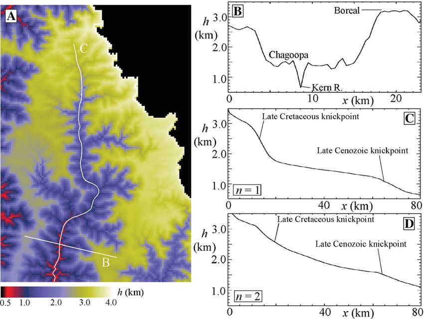
Fig. 5. Illustrations of the topography predicted by the best-fit sediment-flux-driven model results for the North Fork Kern River basin (i.e. 1-km of
latest Cretaceous uplift and 0.5 km of late Cenozoic uplift), illustrating broadly similar features to those of the actual North Fork Kern River basin
(Fig. 1C–E). (D) Longitudinal profile of the best-fit sediment-flux-driven model with n = 2. In this case, the model produces broad cuspate
knickpoints that are not consistent with observed longitudinal profiles.
The rates of vertical incision are lower following the ∼ 10 Ma to the present (Wakabayashi and Sawyer,
second uplift pulse because the knickpoint has a gentler 2001). At first glance this may appear to imply limited
grade due to the smaller magnitude of uplift. erosion in the Sierra Nevada from 55–10 Ma if one
assumes that accumulation rates in the basin are
5. Discussion proportional to upstream erosion rates (Wakabayashi
and Sawyer, 2001). Sedimentary basin accumulation is
The results of this paper support two possible uplift usually controlled by changes in topographic loading at
histories corresponding to the best-fit results of the the basin margins, however. When subsidence and
sediment-flux-driven and stream-power models. Two accumulation rates were high in the southern Great
additional constraints, however, point to the conclusions Valley, the adjacent Sierra Nevada was most likely
of the sediment-flux-driven model, i.e. that range-wide gaining in mean elevation, increasing its load on the
surface uplift occurred first from a low-elevation, low- crust in order to drive flexural subsidence and hence
relief landscape in the latest Cretaceous. First, field generate accommodation space. When accumulation
observations support the hypothesis that sediment rates were low, the mean elevation of the Sierra Nevada
abrasion is the dominant erosional process in granitic was likely undergoing minor change, with sediment
landscapes (Whipple et al., 2000), hence a sediment- eroded from the range bypassing the basin due to the
flux-driven model is most appropriate for the Sierra lack of accommodation space. Accumulation rates
Nevada. Second, the fact that Kw is observed to be a increased again only when the mean elevation of the
function of uplift rate (Snyder et al., 2000; DeLong et al., Sierra Nevada rose again in late Miocene time. The
2007), supports the greater applicability of a sediment- accumulation history in the Great Valley, therefore, is
flux-driven model in mountainous landscapes generally. broadly consistent with the surface uplift history
Accumulation rates in the southern Great Valley inferred from the sediment-flux-driven model.
further support the results of the sediment-flux-driven Both the stream-power and sediment-flux-driven
model. Accumulation rates were high (0.1–0.5 mm/yr) models fail to reproduce the observed topography in at
from 100–55 Ma, low (b0.03 mm/yr) from 55 Ma to least one major respect: they do not reproduce persistent
10 Ma, and moderately high (∼ 0.05–0.2) again from hanging valleys along the lower reaches of the majorJ.D. Pelletier / Earth and Planetary Science Letters 259 (2007) 85–96 95
river canyons. Crosby et al. (2005) argued that very steep slowgeomorphicresponsetotheinitialupliftphaseiscaused
bedrock channels (i.e. bed slopes near vertical) lose by the lack of cutting tools supplied by the slowly eroding
abrasional efficiency because of the oblique angle of uplandBorealPlateau.Ifthebehaviorofthesediment-flux-
incidence between the saltating bedload and channel bed driven model is correct, the model results suggests that
in such steep channels. This “cosine effect” promotes the 32 Myr (i.e. the time since onset of Sierra Nevadan uplift,
formation of hanging valleys in New Zealand and accordingtoClarketal.(2005b)doesnotaffordenoughtime
Taiwan (Wobus et al., 2006). Including this effect in the to propagate the upland knickpoint to its present location.
model would likely improve its realism but would also The self-consistency of the model results provide con-
require a much more finely resolved grid in order to fidence in this interpretation. The model correctly repro-
recognize very steep channels in the model. The cosine duces details of the modern topography of the range,
effect would most likely lengthen the time required for including the elevations and extents of the Chagoopa and
knickpoints to propagate in the model (because hanging Boreal Plateaux and the elevations and shapes of the major
valleys supply less sediment flux to drive downstream riverknickpoints.Thetimingofthetwouplifteventsinferred
incision), thereby pushing back slightly the timing of the frommodelingisbroadlyconsistentwithlateCretaceousand
uplift pulses inferred from the model. lateMioceneepisodesofcrustaldelamination(Saleebyetal.,
Uncertainty in the western extent of Sierran uplift 2003).
translates into uncertainty regarding the timing of initial Low-relief, high-elevation “relict landscapes” are
uplift. In the model, late Cretaceous surface uplift was recognized in many of the world's mountain ranges
prescribed to begin at 60 Ma and cease at 59 Ma, but (e.g. Clark et al., 2005a,b; Barke and Lamb, 2006; Grujic
uplift could have begun significantly earlier if the uplift et al., 2006). The past few years have seen renewed
rate was lower than the 1 mm/yr assumed here, if uplift interest in using these surfaces as surface uplift
extended further west, and/or if past upland erosion rates indicators. The results of this paper, however, indicate
(hence sediment fluxes and knickpoint migration rates) that relict landscapes can persist for tens of millions of
were lower than modern rates. The purpose of the model years or more, and that thermochronologic ages provid-
was to test end-member scenarios for late Cretaceous ing a minimum age for the onset of incision do not
versus late Cenozoic uplift. Given the uncertainties, the necessarily coincide with the onset of range-wide surface
model cannot resolve the detailed history of late uplift.
Cretaceous uplift, and the 60 Ma timing I infer based
on modeling should only be considered a minimum age Acknowledgements
for the cessation of late Cretaceous uplift. The
interpretations of House et al. (1997, 1998, 2001) are I wish to thank Robinson Cecil, George Zandt, and
relevant to this point. Using similar thermochronologi- Clem Chase for helpful conversations. George Hilley
cal data as Clark et al. (2005b), House et al. concluded and Darryl Granger provided very helpful and con-
that most of the incision of the modern mainstem rivers structive reviews.
had been achieved by late Cretaceous time at a distance
of approximately 30 km from the range front. The References
results of this paper do not support such ancient uplift/
canyon cutting, but they could be reconciled with that Anderson, R.S., 2002. Modeling the tor-dotted crests, bedrock edges,
and parabolic profiles of high-alpine surfaces of the Wind River
interpretation if past upland erosion rates were lower
Range, Wyoming. Geomorphology 46, 35–58.
than today, thereby slowing past rates of knickpoint Ashley, G.H., 1935. Studies in Appalachian Mountain sculpture. Geol.
propagation relative to modern rates. Soc. Amer. Bull. 46, 1395–1436.
Barke, R., Lamb, S., 2006. Late Cenozoic uplift of the Eastern
6. Conclusions Cordillera, Bolivian Andes. Earth Planet. Sci. Lett. 249, 350–367.
Cecil, M.R., Ducea, M.N., Reiners, P.W., Chase, C.G., 2006. Cenozoic
exhumation of the northern Sierra Nevada from (U–Th)/He
w?>Theresultsofthispaperareconsistentwiththebasic thermochronology. Geol. Soc. Amer. Bull. 118, 1481–1488.
geomorphic interpretation of Clark et al. (2005b) that the Chase, C.G., Wallace, T.C., 1988. Flexural isostasy and uplift of the
upland plateaux and associated river knickpoints of the Sierra Nevada of California. J. Geophys. Res. 93, 2795–2802.
southernSierraNevadalikelyrecordtwoepisodesofrange- Clark, M.K., House, M.A., Royden, L.H., Whipple, K.X., Burchfiel,
wide surface uplift totaling approximately 1.5 km. The B.C., Zhang, X., Tang, W., 2005a. Late Cenozoic uplift of eastern
Tibet. Geology 33, 525–528.
resultspresentedhere,however,suggestthattheinitial1-km Clark, M.K., Maheo, G., Saleeby, J., Farley, K.A., 2005b. The non-
surface uplift pulse occurred in latest Cretaceous time, not equilibrium landscape of the southern Sierra Nevada, California.
lateCenozoic time. Inthe sediment-flux-drivenmodel, the GSA Today 15, 4–10.96 J.D. Pelletier / Earth and Planetary Science Letters 259 (2007) 85–96 Clark, M.K., Royden, L.H., Whipple, K.X., Burchfiel, B.C., Zhang, implications for the paleotopography of the Sierra Nevada. X., Tang, W., 2006. Use of a regional, relict landscape to measure Tectonics 21, 1–10. vertical deformation of the eastern Tibetan Plateau. J. Geophys. Riebe, C.S., Kirchner, J.W., Granger, D.E., Finkel, R.C., 2000. Res. 111, doi:10.1029/2005JF000294. Erosional equilibrium and disequilibrium in the Sierra Nevada, Crosby, B.T., Whipple, K.X., Gasparini, N.M., Wobus, C.W., 2005. California. Geology 28, 803–806. Knickpoint generation and persistence following base-level fall: Riebe, C.S., Kirchner, J.W., Granger, D.E., Finkel, R.C., 2001. An examination of erosional thresholds in sediment-flux-depen- Minimal climatic control on erosion rates in the Sierra Nevada, dent erosion models. Eos, Trans. – Am. Geophys. Union 86 (52) California. Geology 29, 447–450. (Fall Meeting Supplement, abstract H34A-05). Saleeby, J., Ducea, M., Clemens-Knott, D., 2003. Production and loss Currie, B.S., Rowley, D.B., Tabor, N.J., 2005. Middle Miocene of high-density batholithic root, southern Sierra Nevada, Califor- paleoaltimetry of southern Tibet: implications for the role of nia. Tectonics 22, doi:10.1029/2002TC001374. mantle thickening and delamination in the Himalayan orogen. Sklar, L., Dietrich, W.E., 2001. Sediment and rock strength controls on Geology 33, 181–184. river incision into bedrock. Geology 29, 1087–1090. DeLong, S.B., Pelletier, J.D., Arnold, L., 2007. Bedrock landscape Sklar, L., Dietrich, W.E., 2004. A mechanistic model for river incision evolution modeling: calibration using geochronology and DEM into bedrock by saltating bedload. Water Resour. Res. 40, analysis. Geol. Soc. Amer. Bull. 119, 157–173. doi:10.1029/2003WR002496. Gasparini, N.M., Bras, R.L., Whipple, K.X., 2006. Numerical Small, E.E., Anderson, R.S., 1995. Geomorphically driven late Cenozoic modeling of non-steady-state river profile evolution using a rock uplift in the Sierra Nevada, California. Science 270, 277–281. sediment-flux-dependent incision model. In: Willett, S., et al. Small, E.E., Anderson, R.S., Repka, J.L., Finkel, R., 1997. Erosion (Ed.), Tectonics, Climate, and Landscape Evolution. Geol. Soc. rates of alpine bedrock summit surfaces deduced from 10Be and Am. Spec. Pub., vol. 398, pp. 127–141. 26Al. Earth Planet. Sci. Lett. 150, 413–425. Ghosh, P., Garzione, C.N., Eiler, J.M., 2006. Rapid uplift of the Snyder, N., Whipple, K.X., Tucker, G., Merritts, D., 2000. Landscape Aliplano revealed through 13C–18O bonds in paleosol carbonates. response to tectonic forcing: DEM analysis of stream profiles in Science 311, 511–515. the Mendocino triple junction region, northern California. Geol. Granger, D.E., Riebe, C.S., Kirchner, J.W., Finkel, R.C., 2001. Soc. Amer. Bull. 112, 1250–1263. Modulation of erosion on steep granitic slopes by boulder Stock, G.M., Anderson, R.S., Finkel, R.C., 2004. Pace of landscape armoring, as revealed by cosmogenic 26Al and 10Be. Earth evolution in the Sierra Nevada, California, revealed by cosmogenic Planet. Sci. Lett. 186, 269–281. dating of cave sediments. Geology 32, 193–196. Grujic, D., Coutand, I., Bookhagen, B., Bonnet, S., Blythe, A., Stock, G.M., Anderson, R.S., Finkel, R.C., 2005. Rates of erosion and Duncan, C., 2006. Climatic forcing of erosion, landscape, and topographic evolution of the Sierra Nevada, California, inferred tectonics in the Bhutan Himalayas. Geology 34, 801–804. from cosmogenic 26Al and 10Be concentrations. Earth Surf. House, M.A., Wernicke, B.P., Farley, K.A., Dumitru, T.A., 1997. Process. Landf. 30, 985–1006. Cenozoic thermal evolution of the central Sierra Nevada, Strudley, M.W., Murray, A.B., Haff, P.K., 2006. Regolith-thickness California, from (U–Th)/He thermochronometry. Earth Planet. instability and the formation of tors in arid environments. J. Sci. Lett. 151, 167–179. Geophys. Res. 111, doi:10.1029/2005JF000405. House, M.A., Wernicke, B.P., Farley, K.A., 1998. Dating topography Tucker, G.E., Bras, R.L., 1998. Hillslope processes, drainage density, of the Sierra Nevada, California, using apatite (U–Th)/He ages. and landscape morphology. Water Resour. Res. 34, 2751–2764. Nature 396, 66–69. Turcotte, D.L., Schubert, G., 2002. Geodynamics. Cambridge House, M.A., Wernicke, B.P., Farley, K.A., 2001. Paleogeomorphol- University Press, New York. 456 pp. ogy of the Sierra Nevada, California, from the (U–Th)/He ages in Twidale, C.R., 1976. On the survival of paleoforms. Am. J. Sci. 276, apatite. Am. J. Sci. 301, 77–102. 77–95. Howard, A.D., Kerby, G., 1983. Channel changes in badlands. Geol. Wahrhaftig, C., 1965. Stepped topography of the southern Sierra Soc. Amer. Bull. 94, 739–752. Nevada, California. Geol. Soc. Amer. Bull. 76, 1165–1190. Huber, N.K., 1981. Amount and timing of late Cenozoic uplift and tilt Wakabayashi, J., Sawyer, T.L., 2001. Stream incision, tectonics, uplift, of the central Sierra Nevada, California—evidence from the upper and evolution of topography of the Sierra Nevada, California. J. San Joaquin river basin. U.S. Geol. Surv. Prof. Pap. 1197 (28 pp.). Geol. 109, 539–562. Huber, N.K., 1990. The late Cenozoic evolution of the Tuolumne Webb, R.W., 1946. Geomorphology of the middle Kern River Basin, River, central Sierra Nevada, California. Geol. Soc. Amer. Bull. southern Sierra Nevada, California. Geol. Soc. Amer. Bull. 57, 102, 102–115. 355–382. Jones, C.H., 1987. Is extension in Death Valley accommodated by Whipple, K.X., Tucker, G.E., 1999. Dynamics of the stream-power thinning of the mantle lithosphere beneath the Sierra Nevada, river incision model: implications for height limits of mountain California? Tectonics 6, 449–473. ranges, landscape response timescales, and research needs. J. Molnar, P., 2004. Interactions among topographically-induced elastic Geophys. Res. 104, 17,661–17,674. stress, static fatigue, and valley incision. J. Geophys. Res. 109, Whipple, K.X., Hancock, G.S., Anderson, R.S., 2000. River incision doi:10.1029/2003JF000097. into bedrock: mechanics and relative efficacy of plucking, Montgomery, D.R., Dietrich, W.E., 1999. Where do channels begin? abrasion, and cavitation. Geol. Soc. Amer. Bull. 112, 490–503. Nature 336, 232–234. Wobus, C.W., Crosby, B.T., Whipple, K.X., 2006. Hanging valleys in Mulch, A., Graham, S.A., Chamberlain, C.P., 2006. Hydrogen fluvial systems: controls on occurrence and implications for landscape isotopes in Eocene river gravels and paleoelevation of the Sierra evolution. J. Geophys. Res. 111, doi:10.1029/2005JF000406. Nevada. Science 313, 87–89. Unruh, J.R., 1991. The uplift of the Sierra Nevada and implications for Poage, M.A., Chamberlain, C.P., 2002. Stable isotope evidence for a late Cenozoic epeirogeny in the western Cordillera. Geol. Soc. Pre-Middle Miocene rain shadow in the western Basin and Range: Amer. Bull. 103, 1395–1404.
You can also read