Palaeoseismology: historical and prehistorical records of earthquake ground effects for seismic hazard assessment
←
→
Page content transcription
If your browser does not render page correctly, please read the page content below
Downloaded from http://sp.lyellcollection.org/ by guest on January 24, 2021

Palaeoseismology: historical and prehistorical records of earthquake
           ground effects for seismic hazard assessment
                    K. REICHERTER1*, A. M. MICHETTI2 & P. G. SILVA BARROSO3
      1
          Lehr- und Forschungsgebiet Neotektonik und Georisiken, Geowissenschaften, RWTH
                        Aachen, Lochnerstr. 4-20, D-52064 Aachen, Germany
                2
                 Dipartimento di Scienze Chimiche e Ambientali, Università delĺInsubria,
                                  Via Valleggio 11, 22100 Como, Italy
3
 Departamento de Geologı́a, Universidad de Salamanca, Escuela Politécnica Superior de Ávila,
                      Avda. Hornos Caleros, 50. 05003-Ávila, Spain
                     *Corresponding author (e-mail: k.reicherter@nug.rwth-aachen.de)

This volume grew particularly out of two meetings                  scale (Michetti et al. 2007), which follows the
held in 2006 (European Geosciences Union                           same basic structure of the original Mercalli –
General Assembly 2006, Session TS4.4, ‘3000                        Cancani – Sieberg scale (MCS scale; Sieberg
years of earthquake ground effects in Europe: geo-                 1912), and of the subsequent, widely used,
logical analysis of active faults and benefits for                 Modified Mercalli macroseismic scales
hazard assessment’, Vienna, Austria, April 2006;                   MM-31; (Wood & Neumann 1931) and MM-
and the ICTP/IAEA workshop on ‘The conduct of                      56 (Richter 1958), MSK-64 (Medvedev –
seismic hazard analyses for critical facilities’,                  Sponheuer– Karnik scale; Medvedev et al.
Trieste, Italy, May 2006) that brought together geos-              1964), and EMS-98 (European Macroseismic
cientists who have explored and studied palaeoseis-                Scale; Grünthal 1998).
micity and its environmental effects in several parts        (2)   The guidelines, which aim at better clarifying:
of the world. This publication contains 18 papers                  (i) the background of the scale and the scien-
based on a selection of presentations, and addresses               tific concepts that support the introduction of
a wide range of topics related to both a) palaeoseis-              such a new macroseismic scale; (ii) the pro-
mological studies, and b) the assessment of a new                  cedure to use the scale alone or integrated
macroseismic intensity scale based only on the                     with damage-based, traditional scales; (iii)
natural phenomena associated with an earthquake,                   how the scale is organized; (iv) the descrip-
that is the ESI 2007 scale.                                        tions of diagnostic features required for inten-
    In 1999, during the 15th INQUA (International                  sity assessment, and the meaning of idioms,
Union for Quaternary Research) Congress in                         colours and fonts.
Durban, the Subcommission on Palaeoseismicity
                                                                 The main advantage of the ESI 2007 scale is the
promoted the compilation of a new scale of macro-
                                                             classification, quantification and measurement of
seismic intensity based only on environmental
                                                             several known geological, hydrological, botanical
effects. A working group including geologists, seis-
                                                             and geomorphic features for different intensity
mologists and engineers compiled a first version of
                                                             degrees, differentiating two main categories of
the scale that was presented at the 16th INQUA
                                                             earthquake effects on the environment: (a) primary
Congress in Reno in 2003, and updated one year
                                                             (fault surface ruptures and tectonic uplift/
later at the 32nd International Geological Congress
                                                             subsidence); and (b) secondary (including ground
in Florence (Michetti et al. 2004). To this end, the
                                                             cracks, slope movements, liquefaction processes,
INQUA TERPRO (Commission on Terrestrial Pro-
                                                             anomalous waves and tsunamis, hydrogeological
cesses) approved a specific project (INQUA Scale
                                                             anomalies, and tree shaking). Primary effects trig-
Project 2007). The revised version was ratified
                                                             gered by surface faulting are almost absent for inten-
during the 17th INQUA Congress in Cairns in
                                                             sity degrees below VIII, are characteristic, but
2007. This revised version of the scale, which is for-
                                                             moderate for intensities between VIII and X, and
mally named the Environmental Seismic Intensity
                                                             diagnostic for the stronger top intensities of XI
scale –ESI 2007, is composed of two parts.
                                                             and XII (Fig. 1). This differentiation subdivides
(1)       The definition of intensity degrees on the basis   the earthquakes into three main categories (A, B,
          of coseismic ground effects (see Appendix).        C), in which the absence (A), occurrence (B) and
          ESI 2007 is a 12-degree macroseismic               dimensions (B, C) of fault surface offsets allow

From: REICHERTER , K., MICHETTI , A. M. & SILVA , P. G. (eds) Palaeoseismology: Historical and Prehistorical Records
of Earthquake Ground Effects for Seismic Hazard Assessment. The Geological Society, London, Special Publications,
316, 1–10. DOI: 10.1144/SP316.1 0305-8719/09/$15.00 # The Geological Society of London 2009.
2
Downloaded from http://sp.lyellcollection.org/ by guest on January 24, 2021
K. REICHERTER ET AL.
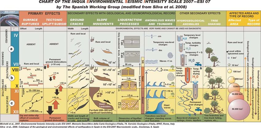
Fig. 1. The ESI 2007 chart summarizes the main features and dimensions of the more relevant Earthquake Environmental Effects (modified after Silva et al. 2008).Downloaded from http://sp.lyellcollection.org/ by guest on January 24, 2021
INTRODUCTION 3
the assignment of intensity to present and past natural surroundings is controversial. Over the
seismic events. Complementarily, the dimension past 40 years at least, proper attention has not
(width, length, volume of mobilized material) of been paid to these effects in estimating intensity,
secondary effects allows intensities to be con- because they were reputed to be too variable, and
strained for type A and B earthquakes; while the likewise because they were not properly weighted
extension of the area affected by secondary effects in the scales. For example, recent data indicate
allows assessment of the epicentral intensity for that some phenomena occur, or start to occur, at
type A, B and C earthquakes. Secondary effects degrees other than the ones they are assigned to in
are typically diagnostic for type B earthquakes, the scales: liquefaction, for instance, starts at
but frequently saturate for type C. In the same way lower intensities (VI– VII, or even V; e.g. Keefer
primary effects are diagnostic for type C earth- 1984; Galli 2000; Porfido et al. 2002; Rodriguez
quakes, when structural damage to human construc- et al. 2002) and not at VII or IX as indicated in
tions and engineering facilities saturate. In most scales. We argue that the existence of similar
principle, both the total area affected by secondary inconsistencies in the available macroseismic
effects and the dimensions (surface rupture length, scales should not lead to the conclusion that
displacement, amount of coseismic uplift or subsi- ground effects are useless for assessing earthquake
dence) of primary effects do not saturate for the intensity.
large earthquakes. The combination of the ESI These uncertainties lead to an increasing lack of
2007 scale with other classic intensity scales confidence in using ground effects as diagnostics,
(MSK, EMS, MM, MCS) helps to compare recorded and progressively the effects on human perception
structural damage with the dimension of observed or and the anthropic environment (mainly buildings)
reported (past earthquakes) environmental effects, became the only sensors analysed for intensity
and consequently exports the obtained seismic assessment. Exemplifying this logic, in the latest
records to past prehistoric events. Figure 1 summar- proposal by the European Seismological Commis-
izes the ESI 2007 chart (Silva et al. 2008), which sion to revise the MSK scale (Grünthal 1998),
illustrates the different categories of earthquakes these effects are not reported in the scale per se,
as well as the main characteristic features for the only in a brief appendix. We believe, however,
different types of effects. Also, this chart gives a that if this orientation is pursued, intensity will
qualitative approach for the affected areas, type of come to reflect mainly the economic development
geological and geomorphologic record, and their of the area that experienced the earthquake
respective degree of preservation through time. instead of its ‘strength’ (Serva 1994). It is also
There is one very important aspect in introducing our belief that by ignoring ground effects, it will
a new intensity scale into the practice. A great deal not be possible to assess intensity accurately in
of work in seismic hazard assessment is accom- sparsely populated areas and/or areas inhabited
plished in the world, and intensity is a basic par- by people with different modes of existence, such
ameter in this. Any ‘new word’ in this research as nomads. This point has been very clearly made
field must not result in dramatic changes. Intensity by Dengler & McPherson (1993). The ESI scale
VIII, for instance, has to mean more or less the is the logical extension of their approach. Further-
same ‘strength’ of the earthquake, regardless of more the main problems arise for the highest
which macroseismic phenomena (anthropic or geo- degrees, XI and XII, where ground effects are the
logical) it is assessed from. Obviously the ESI 2007 only ones that permit a reliable measurement
scale is not intended to replace the existing scales. of the severity of earthquake. All the scales, in
We are simply affording a means to factor in the fact, show that in this range of intensity ground
modifications induced by the earthquake on the effects predominate.
physical environment, and then to compare them We believe the new ESI 2007 scale needs wider
with the effects taken into account by other scales. dissemination to allow a full scientific debate about
There, indeed, the combined observations of its application to take place. One of the purposes
widely varied effects is most likely to yield a more of this Special Publication is thus to open the
representative estimate of intensity, which in turn, debate on a ‘ground effects’ scale for seismic
using modern events as test cases, can then be col- hazard assessment.
lated with such instrumental measurements as mag- It should be noted that the motivation for a new
nitude and seismic moment. A more detailed intensity scale based only on one class of macroseis-
description of the relationships between the ESI mic information, the effects on nature, rests exactly
2007 scales and the other scales is beyond the on the dramatic progress of our knowledge about the
scope of this introduction; for a complete analysis coseismic ground effects, and notably about surface
of this point see Michetti et al. (2004, 2007). faulting, gained in the last 30 years thanks to
The authors of this introduction do not ignore, the growth of palaeoseismological studies. In the
however, that the use of macroseismic effects on monograph Active Tectonics: Impacts on SocietyDownloaded from http://sp.lyellcollection.org/ by guest on January 24, 2021
4 K. REICHERTER ET AL.
(Wallace 1986), the first book that can be regarded Papanikolaou et al. revise the macroseismic
as an overview of palaeoseismology, several information for several earthquakes in Greece in
papers made absolutely clear the quantitative rela- order to calibrate the ESI 2007 scale against the tra-
tions that link the physical phenomena induced ditional, damage-based scales. Their results show
by earthquakes in the natural environment and the how the ESI 2007 scale, following the same criteria
earthquake size. It has become a global, standard for all earthquakes, can compare not only events
practice for palaeoseismologists since the late from different settings, but also contemporary and
1970s to survey in the field immediately after an future earthquakes with historical events. This is
earthquake the distribution of landslides, liquefac- of particular value for seismic hazard assessment
tions, hydrological changes, coastal uplift and subsi- in countries with a long record of seismicity such
dence, and especially the characters and dimensions as Greece.
of tectonic ground ruptures. This is particularly true Two papers take advantage of a very large
for the environmental effects generated by large number of fault trench exposures to draw inference
earthquakes that break the ground surface (e.g. on earthquake hazard and fault behaviour along
Allen 1986). Today, for instance, we have about major strike-slip structures. Rockwell et al. illus-
40 large earthquakes for which the geometry of trate extensive fault trenching across the trace of
surface faulting and the slip distribution along the the coseismic ground ruptures associated with the
fault strike have been mapped in detail (Wesnousky large earthquakes of 9 August 1912 and 17 August
2008). In this way, ground effects can be estimated 1999 along the North Anatolian Fault, west and
from observations and regression analyses of his- east of the Marmara Sea, respectively. This allows
torical earthquakes and a) fault displacement better resolution of the history of surface ruptures
(Slemmons & dePolo 1986), b) liquefaction (Galli for the past 400 years around Istanbul. A better
2000), c) landslides (Keefer 1984), and several quantitative assessment of coseismic environmental
other features. This knowledge was not available effects such as fault displacement is critical for the
at the time of early macroseismic scales, which mitigation of earthquake risk in one of the largest
very wisely included environmental effects in the metropolitan areas of the Earth.
different intensity degrees, but obviously without a Mouslopoulou et al. use fault data from 20
detailed quantitative description due to the poor trenches to explore whether changes in late Quater-
available dataset. There now exists an entirely new nary fault kinematics principally arise due to earth-
catalogue of information that allows us to update quake rupture arrest and/or variations in slip
the macroseismic intensity observations by incor- vector pitch during individual earthquakes that
porating a wealth of palaeoseismological data. span the kinematic transition zone occurring along
Vice-versa, the new macroseismic intensity scale the North Island Fault System, New Zealand, near
based on environmental effects becomes a valuable the intersection with the active Taupo Rift.
tool and a guide for the palaeoseismologist. The Ground effects from four large earthquakes
lessons learned from intensity observations are edu- in Japan and Taiwan have been compiled by
cational for palaeoseismic analyses and interpret- Ota et al. in order to assess the ESI 2007 scale.
ations, because they encourage the specialist to The new resulting maps show more detailed inten-
cross-check the results obtained using one particular sity patterns than those previously available for
evidence of palaeoseismicity. Once an ESI 2007 the four areas. Calibration exercise also reveals,
intensity degree has been assessed from a particular however, that the ESI 2007 intensity scale needs
palaeoseismic feature, consistency with the whole some methodological improvement. This is some-
spectrum of ground effects included in the same what expected and is needed for the better
intensity degree should be ensured. implementation of this new intensity scale in the
In our opinion, this illustrates quite well the future.
scope of the present Special Publication and the A similar exercise is proposed by Tatevossian
basic idea behind all the presented contributions. et al., who used examples from the Altai (27
The volume is divided into two sections. The first September 2003) and the Neftegorsk (27 May
section focuses on the analysis of the coseismic 1995) earthquakes. One of the main points made
ground effects from contemporary and historical by these authors is the relevance of the environ-
earthquakes, and the implementation and refinement mental effects for intensity assessment in the near
of the ESI 2007 scale. The second section is devoted field of strong earthquakes. We argue that this is
to the analysis of individual case histories illustrat- the very fundamental concept which provides reli-
ing the different geological, geomorphological, able relations between palaeoseismology, macro-
geophysical techniques and field-survey methods seismic intensity and seismic hazard assessment.
used to identify causative and capable faults, and The results of Tatevossian et al. should be compared
seismic hazard, from seismological and palaeoseis- with those presented by Ota et al., Mosquera-
mological approaches. Machado et al. and Zahid et al. The epicentralDownloaded from http://sp.lyellcollection.org/ by guest on January 24, 2021
INTRODUCTION 5
intensity (I0) based on the ESI 2007 scale can be two Both Gregersen & Voss and Mörner provide a
to four times higher than I0 assessed without taking comprehensive seismological and palaeoseismolo-
into account the ground effects. This indicates that gical framework for the understanding and
by excluding the environmental effects, especially interpretation, in terms of seismic hazard, of the
primary effects, we not only miss a valuable piece remarkable evidence of post-glacial palaeoseismi-
of information, sometimes the only one available city available in Scandinavia.
in sparsely populated areas, but we are also A particular category of ground effects, that is
missing the low frequency (static) part of an earth- found in the endokarstic terrains, is explored by
quake impact. In the epicentral area of strong Pérez-López et al., starting from the observation
seismic events, where the static offset reaches the of the collapse that occurred within the Benis
order of several metres, intensity assessments ignor- Cave (2213 m; Murcia, SE Spain), during the
ing this component are useless. Mula earthquake (mb ¼ 4.8, MSK VII, 2 February
The integrated identification and analysis of 1999).
archeoseismic and palaeoseismic evidence at the Also in SE Spain (Almerı́a Region), the strati-
Roman site of Baelo Claudia, Gibraltar Strait graphic and sedimentological evidence of past
(south Spain), is the purpose of the work by Silva tsunamis in the western Mediterranean is discussed
et al. These authors combine observations on by Reicherter & Becker-Heidmann. The authors
damage and secondary environmental effects in used shallow drilling in the lagoon of Cabo de
order to assess the local seismic hazard in terms of Gata for identifying possible tsunamites associated
expected recurrence of intensity values within a with the 1522 Almerı́a earthquake.
specific time window. Trenching along the Vilariça segment of the
A similar potential archeoseismic case history in Manteigas-Bragança Fault in NE Portugal, allows
a region with moderate seismicity is presented by Rockwell et al. to identify evidence of a cluster of
Hinzen & Weiner, who apply geotechnical model- surface faulting earthquakes in the latest Pleistocene
ling to test the coseismic hypthesis for the damage to to early Holocene. This holds relevant implications
a Neolithic wooden well recently excavated near for the seismic hazard of this region, characterized
Erkelenz, in the Lower Rhine Embayment (NW by moderate historical seismicity. Likewise, White
Germany). et al. discuss the evidence for recent activity and
Two papers revise earthquake ground effects related seismic hazard along the Hebron Fault in
and active faulting in sparsely populated regions. SW Namibia, within a stable continental area.
Mosquera-Machado et al. studied the Mw 7.3 In summary, the set of papers included in this
Murindo earthquake (18 October 1992) in NW volume is basically devoted to the analysis of
Colombia, which provides relevant data for the environmental earthquake effects linked to recent,
application of the ESI 2007 scale. The resulting past and prehistoric strong seismic events. The
new isoseismal map is relevant for the assessment understanding of the type and dimensions of earth-
of future seismic risk in this part of Colombia quake ground effects linked to different levels of
where intensity assessment based on traditional seismic shaking and earthquake magnitude is the
damage-based scales cannot give a detailed picture only prudent and consistent way to incorporate
of the earthquake severity. The Mw 7.8 Kunlun past strong events, only witnessed in the geological
earthquake (14 November 2001) occurred in north- and geomorphological record, into the classic
ern Tibet, in a remote, high-mountain region. Lin & seismic catalogues, which are the basis of most of
Guo documented for the first time the palaeoseismic the seismic hazard studies and assessments. The
history of this region based on evidence of liquefac- efforts of the palaeoseismological community are
tion within the trace of the 450-km-long surface directed to expanding back in time, and refining
rupture zone generated by this large event. in terms of completeness, the seismic history of
The analysis of the coseismic effects on the individual faults and/or seismic regions, in order
natural environment along the 110-km-long zone to achieve a better understanding of the pulse (regu-
of surface thrust faulting associated with the M 7.6 larity and/or clustering) of seismic cycles in differ-
Muzaffarabad, Pakistan, earthquake of 8 October ent tectonic settings, and its further implementation
2005, is the topic covered by Ali et al., also dis- in hazard studies. Although the ESI 2007 scale is
cussed from the seismotectonic point of view by properly devoted to its application to past earth-
MonaLisa. The macroseismic intensity distribution quakes, its application to recent events is critical,
for this event shows a remarkable correlation with since it will allow refining the scale, and therefore
the trace of the surface rupture. Near Muzaffarabad, improving maximum intensities recorded during
intensity XI in the MM, EMS-98 and ESI 2007 past events. This volume offers to the scientific
scales has been consistently assessed at sites community a new tool to assign intensities, and a
where maximum values of fault displacement (in wide variety of geological methods to identify and
the order of 4 m) were observed. measure earthquake environmental effects.Downloaded from http://sp.lyellcollection.org/ by guest on January 24, 2021
6 K. REICHERTER ET AL.
Many thanks are due to the armada of reviewers, who help as small variations of chemical –physical properties
to shape and focus the scope of this volume (in alphabetical of water and turbidity in lakes, springs and wells.
order): P. Alfaro, F. Audemard, J. Cabral, R. Caputo, (b) In closed basins (lakes, even seas) seiches with height
J. Dolan, F. Dramis, M. Ferry, A. Gorshkov, L. Guerrieri, of decimetres may develop, sometimes noted also by
K. Hinzen, R. Jibson, E. Kagan, J. Lario, T. Little, B. Lund, naked eye, typically in the far field of strong earth-
S. Marco, E. Masana, B. Mohammadioun, K. Okumura,
C. Pascal, S. Pavlides, L. Piccardi, S. Porfido, Y. Quinif, quakes. Anomalous waves up to several tens of centi-
G. Roberts, M. Rodriguez Pascua, L. Serva, M. Sintubin, metres high are perceived by all people on boats and
A. Smedile, B. Shyu, I. Stewart, V. Trifonov and J. van on the coast. Water in swimming pools overflows.
der Woerd. (c) Thin cracks (millimetre wide and several centimetres
up to 1 metre long) are locally seen where lithology
Appendix: ESI 2007 scale definition of (e.g. loose alluvial deposits, saturated soils) and/or
morphology (slopes or ridge crests) are most prone
intensity degrees to this phenomenon.
Text in italic indicates effects that can be used directly to (d) Rare small rockfalls, rotational landslides and slump
define an intensity degree. earth flows may take place, along often but not
necessarily steep slopes where equilibrium is near
From I to III the limit state, mainly loose deposits and saturated
soil. Underwater landslides may be triggered, which
There are no environmental effects that can be used
can induce small anomalous waves in coastal areas
as diagnostic.
of sea and lakes.
(e) Tree limbs and bushes shake slightly, very rare cases
IV Largely observed/First unequivocal of fallen dead limbs and ripe fruit.
effects in the environment (f) Extremely rare cases are reported of liquefaction
(sand boil), small in size and in areas most prone to
Primary effects are absent.
this phenomenon (highly susceptible, recent, alluvial
Secondary effects and coastal deposits, near-surface water table).
(a) Rare small variations of the water level in wells
VI Slightly damaging/Modest effects in the
and/or of the flow rate of springs are locally recorded,
as well as extremely rare small variations of environment
chemical– physical properties of water and turbidity
Primary effects are absent.
in springs and wells, especially within large karstic
spring systems, which appear to be most prone to Secondary effects
this phenomenon.
(a) Significant variations of the water level in wells and/
(b) In closed basins (lakes, even seas) seiches with height
or of the flow rate of springs are locally recorded, as
not exceeding a few centimetres may develop, com-
well as small variations of chemical– physical proper-
monly observed only by tidal gauges, exceptionally
ties of water and turbidity in lakes, springs and wells.
even by naked eye, typically in the far field of
(b) Anomalous waves up to many tens of centimetres high
strong earthquakes. Anomalous waves are perceived
flood very limited areas nearshore. Water in swim-
by all people on small boats, few people on larger
ming pools and small ponds and basins overflows.
boats, most people on the coast. Water in swimming
(c) Occasionally, millimetre to centimetre-wide fractures
pools swings and may sometimes overflows.
and up to several metres long are observed in loose
(c) Hair-thin cracks (millimetre wide) might be occasion-
alluvial deposits and/or saturated soils; along steep
ally seen where lithology (e.g. loose alluvial deposits,
slopes or riverbanks they can be 1 –2 cm wide. A
saturated soils) and/or morphology (slopes or ridge
few minor cracks develop in paved (either asphalt
crests) are most prone to this phenomenon.
or stone) roads.
(d) Exceptionally, rocks may fall and small landslides
(d) Rockfalls and landslides with volume reaching
may be (re)activated, along slopes where the equili-
c. 103 m3 can take place, especially where equili-
brium is already near the limit state, e.g. steep slopes
brium is near the limit state, e.g. steep slopes and
and cuts, with loose and generally saturated soil.
cuts, with loose saturated soil, or highly weathered/
(e) Tree limbs shake feebly.
fractured rocks. Underwater landslides can be
V Strong/Marginal effects in the environment triggered, occasionally provoking small anomalous
waves in coastal areas of sea and lakes, commonly
Primary effects are absent. seen by intrumental records.
(e) Trees and bushes shake moderately to strongly; a
Secondary effects very few tree tops and unstable dead limbs may
(a) Rare variations of the water level in wells and/or of break and fall, also depending on species, fruit load
the flow rate of springs are locally recorded, as well and state of health.Downloaded from http://sp.lyellcollection.org/ by guest on January 24, 2021
INTRODUCTION 7
(f) Rare cases are reported of liquefaction (sand boil), a few centimetres, particularly for very shallow focus
small in size and in areas most prone to this phenom- earthquakes such as those common in volcanic areas.
enon (highly susceptible, recent, alluvial and coastal Tectonic subsidence or uplift of the ground surface
deposits, near surface water table). with maximum values on the order of a few centimetres
may occur.
VII Damaging/Appreciable effects
in the environment Secondary effects. The total affected area is in the
order of 100 km2.
Primary effects observed very rarely, and almost
exclusively in volcanic areas. Limited surface fault rup- (a) Springs may change, generally temporarily, their flow
tures, tens to hundreds of metres long and with centimetric rate and/or elevation of outcrop. Some small springs
offset, may occur, essentially associated with very may even run dry. Variations in water level are
shallow earthquakes. observed in wells. Weak variations of chemical–
physical properties of water, most commonly temp-
Secondary effects. The total affected area is in the order erature, may be observed in springs and/or wells.
of 10 km2. Water turbidity may appear in closed basins, rivers,
(a) Significant temporary variations of the water level in wells and springs. Gas emissions, often sulphurous,
wells and/or of the flow rate of springs are locally are locally observed.
recorded. Seldom, small springs may temporarily (b) Anomalous waves up to 1 –2 metres high flood near-
run dry or appear. Weak variations of chemical – shore areas and may damage or wash away objects of
physical properties of water and turbidity in lakes, variable size. Erosion and dumping of waste is
springs and wells are locally observed. observed along the beaches, where some bushes and
(b) Anomalous waves even higher than a metre may even small weak-rooted trees can be uprooted and
flood limited nearshore areas and damage or wash drift away. Water violently overflows from small
away objects of variable size. Water overflows from basins and watercourses.
small basins and watercourses. (c) Fractures up to 50 cm wide are and up to hundreds of
(c) Fractures up to 5 –10 cm wide and up to a hundred metres long commonly observed in loose alluvial
metres long are observed, commonly in loose alluvial deposits and/or saturated soils; in rare cases
deposits and/or saturated soils; rarely in dry sand, fractures up to 1 cm can be observed in competent
sand– clay, and clay soil fractures, up to 1 cm wide. dry rocks. Decimetric cracks common in paved
Centimetre-wide cracks are common in paved (asphalt or stone) roads, as well as small pressure
(asphalt or stone) roads. undulations.
(d) Scattered landslides occur in prone areas, where equi- (d) Small to moderate (103 –105 m3) landslides are wide-
librium is unstable (steep slopes of loose/saturated spread in prone areas; rarely they can occur also on
soils), while modest rock falls are common on steep gentle slopes. Where equilibrium is unstable (steep
gorges, cliffs). Their size is sometimes significant slopes of loose/saturated soils; rock falls on steep
(103 –105 m3); in dry sand, sand–clay and clay soil, gorges, coastal cliffs) their size is sometimes large
the volumes are usually up to 100 m3. Ruptures, (105 – 106 m3). Landslides can occasionally dam
slides and falls may affect riverbanks and artificial narrow valleys causing temporary or even permanent
embankments and excavations (e.g. road cuts, quar- lakes. Ruptures, slides and falls affect riverbanks
ries) in loose sediment or weathered/fractured rock. and artificial embankments and excavations (e.g.
Significant underwater landslides can be triggered, road cuts, quarries) in loose sediment or weathered/
provoking anomalous waves in coastal areas of sea fractured rock. Frequent occurrence of landslides
and lakes, directly felt by people on boats and ports. below sea level in coastal areas.
(e) Trees and bushes shake vigorously; especially in (e) Trees shake vigorously; branches may break and fall,
densely forested areas, many limbs and tops break trees even uprooted, especially along steep slopes.
and fall. (f) Liquefaction may be frequent in the epicentral area,
(f) Rare cases are reported of liquefaction, with sand depending on local conditions; sand boils up to
boils up to 50 cm in diameter, in areas most prone c. 1 m in diameter; apparent water fountains in still
to this phenomenon (highly susceptible, recent, allu- waters; localized lateral spreading and settlements
vial and coastal deposits, near surface water table). (subsidence up to c. 30 cm), with fissuring parallel
to waterfront areas (river banks, lakes, canals,
seashores).
VIII Heavily damaging/Extensive effects
(g) In dry areas, dust clouds may rise from the ground in
in the environment the epicentral area.
Primary effects are observed rarely. (h) Stones and even small boulders and tree trunks may
Ground ruptures (surface faulting) may develop, up be thrown in the air, leaving typical imprints in
to several hundred metres long, with offsets not exceeding soft soil.Downloaded from http://sp.lyellcollection.org/ by guest on January 24, 2021
8 K. REICHERTER ET AL.
IX Destructive/Effects in the environment settlements (subsidence of more than c. 30 cm), with
are a widespread source of considerable fissuring parallel to waterfront areas (river banks,
lakes, canals, seashores).
hazard and become important for intensity (g) In dry areas, dust clouds commonly rise from the
assessment ground.
(h) Small boulders and tree trunks may be thrown in the
Primary effects are observed commonly. air and move away from their site for metres, also
Ground ruptures (surface faulting) develop, up to a few depending on slope angle and roundness, leaving
kilometres long, with offsets generally in the order of typical imprints in soft soil.
several centimetres. Tectonic subsidence or uplift of the
ground surface with maximum values in the order of a X Very destructive/Effects on the environment
few decimetres may occur.
become a leading source of hazard and are
Secondary effects. The total affected area is in the critical for intensity assessment
order of 1000 km2. Primary effects become leading.
(a) Springs can change, generally temporarily, their flow Surface faulting can extend for a few tens of kilometres,
rate and/or location to a considerable extent. Some with offsets from tens of centimetres up to a few metres.
modest springs may even run dry. Temporary vari- Gravity grabens and elongated depressions develop; for
ations of water level are commonly observed in very shallow focus earthquakes in volcanic areas rupture
wells. Water temperature often changes in springs lengths might be much lower. Tectonic subsidence or
and/or wells. Variations of chemical–physical prop- uplift of the ground surface with maximum values in the
erties of water, most commonly temperature, are order of a few metres may occur.
observed in springs and/or wells. Water turbidity is
common in closed basins, rivers, wells and springs. Secondary effects. The total affected area is in the
Gas emissions, often sulphurous, are observed, and order of 5000 km2.
bushes and grass near emission zones may burn. (a) Many springs significantly change their flow rate
(b) Waves several metres high develop in still and and/or elevation of outcrop. Some springs may run
running waters. In flood plains water streams may temporarily or even permanently dry. Temporary
even change their course, also because of land subsi- variations of water level are commonly observed in
dence. Small basins may appear or be emptied. wells. Even strong variations of chemical – physical
Depending on shape of sea bottom and coastline, properties of water, most commonly temperature,
dangerous tsunamis may reach the shores with are observed in springs and/or wells. Often water
runups of up to several metres flooding wide areas. becomes very muddy in even large basins, rivers,
Widespread erosion and dumping of waste is wells and springs. Gas emissions, often sulphurous,
observed along the beaches, where bushes and trees are observed, and bushes and grass near emission
can be uprooted and drift away. zones may burn.
(c) Fractures up to 100 cm wide and up to hundreds of (b) Waves several metres high develop in even big lakes
metres long are commonly observed in loose alluvial and rivers, which overflow from their beds. In flood
deposits and/or saturated soils; in competent rocks plains rivers may change their course, temporarily
they can reach up to 10 cm. Significant cracks are or even permanently, also because of widespread
common in paved (asphalt or stone) roads, as well land subsidence. Basins may appear or be emptied.
as small pressure undulations. Depending on shape of sea bottom and coastline,
(d) Landsliding widespread in prone areas, also on tsunamis may reach the shores with runups exceeding
gentle slopes; where equilibrium is unstable (steep 5 m flooding flat areas for thousands of metres inland.
slopes of loose/saturated soils; rock falls on steep Small boulders can be dragged for many metres.
gorges, coastal cliffs) their size is frequently large Widespread deep erosion is observed along the
(105 m3), sometimes very large (106 m3). Landslides shores, with noteworthy changes of the coastline
can dam narrow valleys causing temporary or even profile. Trees nearshore are uprooted and drift away.
permanent lakes. Riverbanks, artificial embankments (c) Open ground cracks up to more than 1 m wide and up
and excavations (e.g. road cuts, quarries) frequently to hundreds of metres long are frequent, mainly in
collapse. Frequent large landslides below sea level in loose alluvial deposits and/or saturated soils; in
coastal areas. competent rocks opening is reach several decimetres.
(e) Trees shake vigorously; branches and thin tree trunks Wide cracks develop in paved (asphalt or stone)
frequently break and fall. Some trees might be roads, as well as pressure undulations.
uprooted and fall, especially along steep slopes. (d) Large landslides and rock-falls (.105 – 106 m3) are
(f) Liquefaction and water upsurge are frequent; sand frequent, almost regardless of equilibrium state of
boils up to 3 m in diameter; apparent water fountains the slopes, causing temporary or permanent barrier
in still waters; frequent lateral spreading and lakes. River banks, artificial embankments, andDownloaded from http://sp.lyellcollection.org/ by guest on January 24, 2021
INTRODUCTION 9
sides of excavations typically collapse. Levees and and/or saturated soils. In competent rocks they
earth dams may even incur serious damage. Frequent can reach 1 m. Very wide cracks develop in paved
large landslides below sea level in coastal areas. (asphalt or stone) roads, as well as large pressure
(e) Trees shake vigorously; many branches and tree undulations.
trunks break and fall. Some trees might be uprooted (d) Large landslides and rock-falls (.105 – 106 m3) are
and fall. frequent, practically regardless to equilibrium state
(f) Liquefaction, with water upsurge and soil compac- of the slopes, causing many temporary or permanent
tion, may change the aspect of wide zones; sand vol- barrier lakes. River banks, artificial embankments,
canoes even more than 6 m in diameter; vertical and sides of excavations typically collapse. Levees
subsidence even .1 m; large and long fissures due and earth dams incur serious damage. Significant
to lateral spreading are common. landslides can occur at 200– 300 km distance from
(g) In dry areas, dust clouds may rise from the ground. the epicentre. Frequent large landslides below sea
(h) Boulders (diameter in excess of 2 –3 m) can be level in coastal areas.
thrown in the air and move away from their site (e) Trees shake vigorously; many branches and tree
for hundreds of metres down even gentle slopes, trunks break and fall. Many trees are uprooted and
leaving typical imprints in soil. fall.
(f) Liquefaction changes the aspect of extensive zones of
XI Devastating/Effects on the environment lowland, determining vertical subsidence possibly
become decisive for intensity assessment, exceeding several metres, numerous large sand vol-
due to saturation of structural damage canoes, and severe lateral spreading features.
(g) In dry areas dust clouds rise from the ground.
Primary effects are dominant. (h) Big boulders (diameter of several metres) can be
Surface faulting extends from several tens of kilometres thrown in the air and move away from their site for
up to more than one hundred kilometres, accompanied by long distances down even gentle slopes, leaving
offsets reaching several metres. Gravity graben, elongated typical imprints in soil.
depressions and pressure ridges develop. Drainage lines
can be seriously offset. Tectonic subsidence or uplift of XII Completely devastating/Effects in the
the ground surface with maximum values in the order of environment are the only tool for intensity
numerous metres may occur. assessment
Secondary effects. The total affected area is in the Primary effects are dominant.
order of 10 000 km2. Surface faulting is at least a few hundreds of kilometres
(a) Many springs significantly change their flow rate long, accompanied by offsets reaching several tens of
and/or elevation of outcrop. Many springs may metres. Gravity graben, elongated depressions and
run temporarily or even permanently dry. Temporary pressure ridges develop. Drainage lines can be seri-
or permanent variations of water level are gene- ously offset. Landscape and geomorphological changes
rally observed in wells. Even strong variations of induced by primary effects can attain extraordinary
chemical– physical properties of water, most com- extent and size (typical examples are the uplift or subsi-
monly temperature, are observed in springs and/or dence of coastlines by several metres, appearance or dis-
wells. Often water becomes very muddy in even appearance from sight of significant landscape elements,
large basins, rivers, wells and springs. Gas emissions, rivers changing course, origination of waterfalls, for-
often sulphurous, are observed, and bushes and grass mation or disappearance of lakes).
near emission zones may burn.
(b) Large waves develop in big lakes and rivers, which Secondary effects. The total affected area is in the
overflow from their beds. In flood plains rivers can order of 50 000 km2 and more.
change their course, temporarily or even perma- (a) Many springs significantly change their flow-rate
nently, also because of widespread land subsidence and/or elevation of outcrop. Temporary or permanent
and landsliding. Basins may appear or be emptied. variations of water level are generally observed in
Depending on shape of sea bottom and coastline, wells. Many springs and wells may run temporarily
tsunamis may reach the shores with runups reaching or even permanently dry. Strong variations of
15 m and more devastating flat areas for kilometres chemical–physical properties of water, most com-
inland. Even metre-sized boulders can be dragged monly temperature, are observed in springs and/or
for long distances. Widespread deep erosion is wells. Water becomes very muddy in even large
observed along the shores, with noteworthy changes basins, rivers, wells and springs. Gas emissions,
of the coastal morphology. Trees nearshore are often sulphurous, are observed, and bushes and
uprooted and drift away. grass near emission zones may burn.
(c) Open ground cracks up to several metres wide are (b) Giant waves develop in lakes and rivers, which
very frequent, mainly in loose alluvial deposits overflow from their beds. In flood plains riversDownloaded from http://sp.lyellcollection.org/ by guest on January 24, 2021
10 K. REICHERTER ET AL.
change their course and even their flow direction, Luxembourg, Cahiers du Centre Européen de
temporarily or even permanently, also because of Géodynamique et de Séismologie, 15.
widespread land subsidence and landsliding. Large INQUA Scale Project, 2007. Available online at http://
basins may appear or be emptied. Depending on www.apat.gov.it/site/en-GB/Projects/INQUA_ Scale
shape of sea bottom and coastline, tsunamis may K EEFER , D. K. 1984. Landslides caused by earth-
quakes. Geological Society of America Bulletin, 95,
reach the shores with runups of several tens of 406–421.
metres devastating flat areas for many kilometres M EDVEDEV , S., S PONHEUER , W. & K ARNÍK , V. 1964.
inland. Big boulders can be dragged for long dis- Neue seismische Skala. 7. Tagung der Europäischen
tances. Widespread deep erosion is observed along Seismologischen Kommission vom 24.9. bis 30.9.
the shores, with outstanding changes of the coastal 1962 in Jena, Veröff. Institut für Bodendynamik und
morphology. Many trees are uprooted and drift Erdbebenforschung in Jena, Deutsche Akademie der
away. All boats are torn from their moorings and Wissenschaften zu Berlin, 77, 69– 76.
swept away or carried onshore even for long dis- M ICHETTI , A. M., E SPOSITO , E. ET AL . 2004. The INQUA
Scale. An innovative approach for assessing earth-
tances. All people outdoors are swept away.
quake intensities based on seismically-induced
(c) Ground open cracks are very frequent, up to one
ground effects in natural environment. In: V ITTORI ,
metre or more wide in the bedrock, up to more than E. & C OMERCI , V. (eds) Special Paper, APAT,
10 m wide in loose alluvial deposits and/or saturated Memorie Descrittive della Carta geologica d’Italia,
soils. These may extend up to several kilometres LXVII. SystemCart Srl, Roma, Italy.
in length. M ICHETTI , A. M., E SPOSITO , E. ET AL . 2007. Environ-
(d) Large landslides and rock-falls (.105 –106 m3) are mental Seismic Intensity Scale 2007 – ESI 2007.
frequent, practically regardless of equilibrium state In: V ITTORI , E. & G UERRIERI , L. (eds) Memorie
of the slopes, causing many temporary or permanent Descrittive della Carta Geologica d’Italia,
barrier lakes. River banks, artificial embankments, LXXIV. Servizio Geologico d’Italia, Dipartimento
Difesa del Suolo, APAT, SystemCart Srl, Roma,
and sides of excavations typically collapse. Levees Italy, 7– 54.
and earth dams incur serious damage. Significant P ORFIDO , S., E SPOSITO , E. ET AL . 2002. Areal distri-
landslides can occur at more than 200 –300 km bution of ground effects induced by strong earthquakes
distance from the epicentre. Frequent very large in the southern Apennines (Italy). Surveys in Geophy-
landslides below sea level in coastal areas. sics, 23, 529–562.
(e) Trees shake vigorously; many branches and tree R ICHTER , C. F. 1958. Elementary Seismology. W. H.
trunks break and fall. Many trees are uprooted Freeman, San Francisco.
and fall. R ODRIGUEZ , L. M., A UDEMARD , F. A. & R ODRIGUEZ ,
J. A. 2002. Casos històricos y contemporaneos de
(f) Liquefaction occurs over large areas and changes the
licuefacion de sedimentos inducidos por sismos
morphology of extensive flat zones, determining verti-
en Venezuela desde 1530. III Jornadas Venezolanas
cal subsidence exceeding several metres, widespread de Sismologı̀a Historica, Serie Tecnica, 1, 4–10.
large sand volcanoes, and extensive severe lateral S ERVA , L. 1994. Ground effects in the intensity scales.
spreading features. Terra Nova, 6, 414–416.
(g) In dry areas dust clouds rise from the ground. S IEBERG , A. 1912. Über die makroseismische
(h) Very big boulders can be thrown in the air and move Bestimmung der Erdbebenstärke. Gerlands Beitrage
for long distances even down very gentle slopes, Geophysik, 11, 227–239.
leaving typical imprints in soil. S ILVA , P. G., R ODRÍGUEZ P ASCUA , M. A. ET AL . 2008.
Catalogación de los efectos geológicos y ambientales
de los terremotos en España en la Escala ESI-2007
References y su aplicación a los estudios paleosismológicos.
Geotemas, 6, 1063–1066.
A LLEN , C. R. 1986. Seismological and paleoseismological S LEMMONS , D. B. & DE P OLO , C. M. 1986. Evaluation of
techniques of research in active tectonics. In: active faulting and associated hazards. In: W ALLACE ,
W ALLACE , R. E. (ed.) Active Tectonics: Impacts on R. E. (ed.) Active Tectonics: Impacts on Society.
Society. National Academy Press, Washington, D.C., National Academy Press, Washington, D.C., Studies
Studies in Geophysics, 148– 154. in Geophysics, 45– 62.
D ENGLER , L. & M C P HERSON , R. 1993. The 17 August W ALLACE , R. E. 1986. Active Tectonics: Impacts on
1991 Honeydew earthquake, North Coast California: Society, National Academy Press, Washington, D.C.,
a case for revising the Modified Mercalli scale in spar- Studies in Geophysics.
sely populated areas. Bulletin of the Seismological W OOD , H. O. & N EUMANN , F. 1931. Modified Mercalli
Society of America, 83, 1081– 1094. Intensity Scale of 1931. Bulletin of the Seismological
G ALLI , P. 2000. New empirical relationships between Society of America, 21(4), 277– 283.
magnitude and distance for liquefaction. Tectonophy- W ESNOUSKY , S. G. 2008. Displacement and
sics, 324, 169–187. geometrical characteristics of earthquake surface
G RÜNTHAL , G. (ed.) 1998. European Macroseismic Scale ruptures: issues and implications for seismic-hazard
1998 (EMS-98). European Seismological Commission, analysis and the process of earthquake rupture. Bulletin
Subcommission on Engineering Seismology, Working of the Seismological Society of America, 98(4),
Group Macroseismic Scales. Conseil de l’Europe, 1609– 1632.You can also read