Puyango, Ecuador Petrified Forest, a Geological Heritage of the Cretaceous Albian-Middle, and Its Relevance for the Sustainable Development of ...
←
→
Page content transcription
If your browser does not render page correctly, please read the page content below
sustainability

Article
Puyango, Ecuador Petrified Forest, a Geological
Heritage of the Cretaceous Albian-Middle, and Its
Relevance for the Sustainable Development
of Geotourism
Fernando Morante-Carballo 1,2,3, * , Geanella Herrera-Narváez 1,4, *, Nelson Jiménez-Orellana 4
and Paúl Carrión-Mero 1,4
 1    Centro de Investigación y Proyectos Aplicados a las Ciencias de la Tierra (CIPAT), ESPOL Polytechnic
      University, Campus Gustavo Galindo Km. 30.5 Vía Perimetral, 9015863 Guayaquil, Ecuador;
      pcarrion@espol.edu.ec
 2    Facultad de Ciencias Naturales y Matemáticas (FCNM), ESPOL Polytechnic University, Campus Gustavo
      Galindo Km. 30.5 Vía Perimetral, 9015863 Guayaquil, Ecuador
 3    Geo-recursos y Aplicaciones GIGA, ESPOL Polytechnic University, Campus Gustavo Galindo Km. 30.5 Vía
      Perimetral, 9015863 Guayaquil, Ecuador
 4    Facultad de Ingeniería en Ciencias de la Tierra (FICT), ESPOL Polytechnic University, Campus Gustavo
      Galindo Km 30.5 Vía Perimetral, 9015863 Guayaquil, Ecuador; nmjimene@espol.edu.ec
 *    Correspondence: fmorante@espol.edu.ec (F.M.-C.); geamiher@espol.edu.ec (G.H.-N);
      Tel.: +59-396-976-0276 (F.M.-C.)

 Received: 7 July 2020; Accepted: 6 August 2020; Published: 14 August 2020

 Abstract: Geodiversity treaties have multiplied and given rise to geological heritage as a singular
 value of protection and preservation for territories. The Puyango Petrified Forest (PPF) is a recognized
 Ecuadorian reserve, which was declared a National Heritage Treasure. It has an area of 2659 hectares,
 and it is located in the south of Ecuador, between the provinces of El Oro and Loja. The petrified trunks
 and trees were buried by volcanic lava, dating from the Cretaceous Period, 96 to 112 million years ago.
 Thus, silicification and carbonization, two important fossilization events, have produced hundreds
 of samples of paleontological wealth in Puyango. The objective of this work is to methodologically
 assess the geodiversity of a fraction of the PPF by registering its geological heritage and value for its
 preservation and sustainable development. The methodology is based on: (i) Analysis of information
 on the territory used for tourist visits, as a pilot study area. Presentation of paleontological components
 and their main sections to enhance their geotouristics value; (ii) Assessment of the geological heritage
 for its geotourism categorization with a recognized scientific methodology and one proposed by the
 co-authors propose; and (iii) Analysis of Strengths, Weaknesses, Opportunities, and Threats (SWOT)
 as a guide for protection and development strategies. Findings reveal the high geotourism potential
 for a Geopark Project in Puyango, since only 300 hectares are used for tourism and the remaining
 area is a virgin environment for research and improving knowledge of geodiversity and biodiversity.

 Keywords: petrified forest; sustainable development; geodiversity; biodiversity; Puyango; geopark

1. Introduction
     Geodiversity considers all the geological elements of the Earth’s crust, from the landscape to its
internal structure that constitutes the various materials such as rocks, minerals and fossils. It is an
inanimate part of nature, but at the same time significant to sustaining biodiversity, since the soil and
subsoil generated by a series of geological processes are what sustain it, and what together are part
of the natural beauty of a site; however, geodiversity has been downplayed by historically giving

Sustainability 2020, 12, 6579; doi:10.3390/su12166579                        www.mdpi.com/journal/sustainability
Sustainability 2020, 12, 6579                                                                         2 of 24

greater prominence to biodiversity [1]. Thus, the term geodiversity refers to the quality, spectacularity,
and beauty of a site of an abiotic nature, which is why it deserves conservation [2]. The protection and
conservation of geodiversity is an issue that until recently was not understood. However, this failure is
being overcome thanks to the close link that exists between biodiversity and geodiversity, which can be
achieved through proper management to preserve biocenosis and the biotope in an integral way [3,4].
      Currently, the geological heritage is promoted and protected adequately towards the sustainable
development of geotourism; this term emphasizes a form of tourism to natural areas that focuses
explicitly on geology and landscape, promoting geosite tourism and the conservation of geodiversity
for a better understanding of the earth sciences through appreciation and learning [5]. In geological
terms, a geosite is defined by its scientific value that demonstrates the importance of the geological
heritage of a specific area, which must be relevant and of importance to science [6]. This is
accomplished through independent visits to geological features, such as geo-trails and viewpoints,
guided tours, geo-activities, and the sponsorship of geosite visitor centres [7,8]. The term Geoheritage
considers particular elements of geodiversity (petrological, geomorphological, structural, mineralogical,
paleontological, stratigraphic, hydrogeological, pedological, among others) with a high scientific
value [9]. Paleontological heritage of a geosite is the study of its scientific value through fossils,
which are testimonies of life in the past, and which also reflect certain events in the geological history of
Earth. Around them and the deposits in which they were found, numerous scientific features converge
that can be considered objectively, allowing their value to be established; such as fossil types, relative
age, state of conservation, among others. Therefore, paleontological heritage is part of the geological
and natural heritage [10].
      Geodiversity is evident that the fossils and deposits have meaning and provide information
on the history of Life and Earth. Morevoer, the scientific component is relevant to place fossils and
sites on a theoretical scale of paleontological value [11]. Fossil forests or petrified forests register a
remarkable geological-paleontological heritage characterized by the wood of trees that has been buried
under sediments and preserved by the absence of oxygen [12]. This type of fossilization is known as
permineralization and emphasizes the replacement of the body’s molecules by minerals. In this case,
petrified wood explains vegetal biodiversity of diverse historical times since it preserves its original
structure to a microscopic level.
      There are more than 20 specimens of petrified forests worldwide and only 3 belong to America—
the Petrified Forest National Park in Arizona-United States, the Petrified Forest of Santa Cruz Natural
Monument in Patagonia, Argentina, and the Puyango Petrified Forest in Ecuador. All these forests
are remarkable for their age, surface and paleontological wealth [13]. In Ecuador, forests cover 42%
of the country’s total area; half of the area is used for production [14]. Dry forests are of particular
importance, since they have less biodiversity than rainforests, but they are the habitat of more than
130 species of birds. These forests are located in two different areas: (a) on the central Pacific coast,
which corresponds to the provinces of Esmeraldas, Manabí, Santa Elena and Guayas; and (b) in the
southern coast and western foothills of the Andes in El Oro and Loja that comprise the equatorial dry
forest with a unique ecosystem in the world [15]. In the past, 35% of western Ecuador was covered by
dry forest. However, 75% of the area has disappeared due to deforestation pressures and growth of the
agricultural and livestock frontier.
      Furthermore, PPF is recognized for its heritage as a true paleontological jewel that contains a
large number of petrified trees of approximately 100 million years old, where the largest collection of
petrified wood in the world is located. One of its largest specimens is the Petrino with dimensions of
2 m in diameter and 15 m in length. Its magnificence is given by a large number of petrified trunks
that open the door to family, educational, scientific, geological-paleontological and naturist tourism.
PPF is a unique beauty in the region with remnants of trees such as trunks and petrified leaves of
Mesozoic flora, and fossils of invertebrates such as bivalves, ammonites, echinoderms, among others.
Furthermore, its biodiversity coexists protected by the great slopes and breaks of the area [16,17].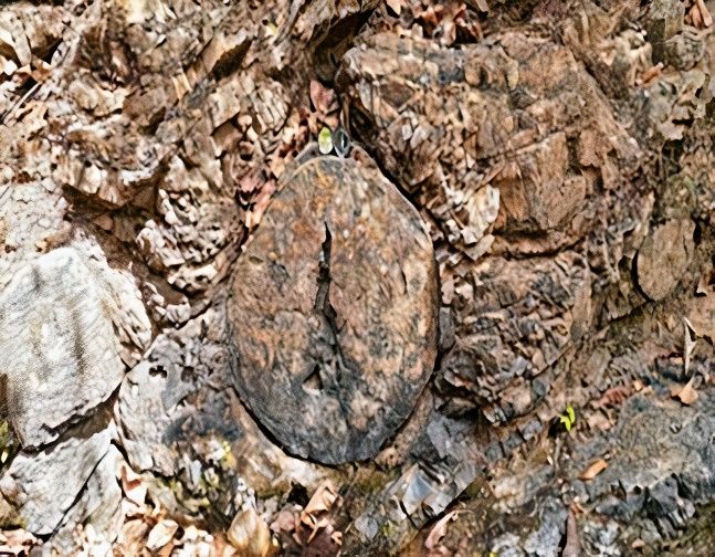
Sustainability 2020, 12, 6579                                                                        3 of 24

     In this regard, this study aims to respond the question: Could we define PPF as a geological
heritage and a driving force for geotourism for its spectacularity, good exposure, paleontology,
biostratigraphy, and stratigraphic content? Hence, the objective is to methodologically assess the
geodiversity of a fraction of PPF as a pilot project, register its outstanding components (geological
heritage) and value it for the preservation and sustainable development of the entire forest. For these
purposes, an assessment is carried out using the scientific method of the Spanish Inventory of Places of
Geological Interest (IELIG, acronym in Spanish) [18]. Moreover, some research-level experiences are
recorded to assess sites of geological interest that could be considered as geosites [19,20].

2. Overview of the Study Area
     Puyango forest is in the southern region of Ecuador, located in the canton Las Lajas, province
of El Oro and Puyango-Alamor, canton-parish of the province of Loja. The cantons are divided by
the Puyango river, located 7 km from the border with Peru. The forest occupies an extension of
2658 hectares (Figure 1), and in 1971, it was discovered by the academic staff of the Huaquillas night
school that named it “Petrified Forest of Puyango” [20]. In 1973, PPF was declared Cultural Heritage
On 9th January 1987 through Ministerial Agreement No. 22, it was declared a protected forest and
vegetation due to the efforts of El Oro Cultural Development Center and the Central Bank of Ecuador.
Later, in March 1988, it was declared part of the Natural Heritage of Ecuador [21,22].
     This region is mountainous, with heights between 360 and 500 m.a.s.l. The current flora and fauna
represent a group of transitional forms between the Pacific lowlands and the Andean elevations [23].
The biodiversity of the area corresponds to a tropical dry forest, which is one of the most threatened
ecosystems in the world, and its species belong to the Tumbesino Center of endemism owned by
Ecuador and Peru [8]. Due to the geomorphological conditions of the area, caused by tectonic events
and modeled by the erosion of rivers, PPF presents a great potential for geotourism appeal in this area
for the exposure of petrified logs, a product of the fossilization process [24,25].
     Puyango Petrified Forest (PPF) is considered one of the few remnants of tropical dry forest in
the southwest of the country, where steep slopes and streams such as El Guineo, Las Concreciones,
El Chirimoyo, El Limón, Sábalos and Cochurco have preserved the endemic vegetation of its ecosystem
and other areas of secondary forest in recovery. In fact, stratigraphic units reveal a fossil richness of
invertebrates of the phylum Mollusca and microfossils of foraminifera and calcareous nanofossils [26].
Puyango is an open book of geological succession and paleontological information of high scientific
value for society, since it is one of the most representative and relevant forests in South America.
PPF has been compared to the Petrified Forest National Park in Arizona, United States—the largest in
the world with more than 20,000 hectares. It has petrified tree trunks belonging to the Araucarioxylon
arizonicum that are preserved from a conifer corresponding to the Late Triassic Period, already extinct
in our times. Moreover, it has fern plant fossils, animals such as the Chinle frogs of the Chinle Geological
Formation, and it is the habitat of a great variety of mammals, fauna, birds, reptiles, and amphibians in
a desert environment [27].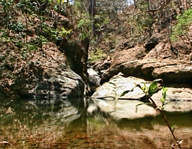
Sustainability 2020, 12,
Sustainability 2020, 12, 6579
                         x FOR PEER REVIEW                                                              44 of
                                                                                                           of 24
                                                                                                              24

     Figure 1. Study area of the Puyango Petrified Forest and its geosites in the provinces of El Oro and
     Loja. Modified from [28].
     Figure 1. Study area of the Puyango Petrified Forest and its geosites in the provinces of El Oro and
     Loja. Modified from [28].
      Before becoming a tropical dry forest, Puyango was a sea, which dried up and transformed into
large hectares of forests and animals. Due to natural cataclysms, geological movements and time,
      Before becoming a tropical dry forest, Puyango was a sea, which dried up and transformed into
the organisms buried underground arose on the surface forming a trace of the planet’s remote past
large hectares of forests and animals. Due to natural cataclysms, geological movements and time, the
and a transcendent number of ancient and representative fossils that correspond to marine organisms
organisms buried underground arose on the surface forming a trace of the planet’s remote past and
that currently oscillate between 60 and 120 million years [26]. In this regard, Puyango emerged under
a transcendent number of ancient and representative fossils that correspond to marine organisms that
coastal and terrestrial marine conditions in a relatively narrow basin caused by the continuous erosive
currently oscillate between 60 and 120 million years [26]. In this regard, Puyango emerged under
tectonism, deformation, displacement, and deposits of pyroclastic materials during the Cretaceous.
coastal and terrestrial marine conditions in a relatively narrow basin caused by the continuous
Before the Andes rose to the end of the Cretaceous 65 million years ago, gymnosperm forests originated
erosive tectonism, deformation, displacement, and deposits of pyroclastic materials during the
on a relatively flat area like the lithified sediments that currently lean in different directions due to
Cretaceous. Before the Andes rose to the end of the Cretaceous 65 million years ago, gymnosperm
folding and tectonism. During this period, the area had a warm temperature. However, with the
forests originated on a relatively flat area like the lithified sediments that currently lean in different
floods and volcanic activity east of the Andes, the forests were destroyed and deposits of buried
directions due to folding and tectonism. During this period, the area had a warm temperature.
trunk layers in alternating sequences of siltstones, sandstones, graywackes and conglomerates were
However, with the floods and volcanic activity east of the Andes, the forests were destroyed and
reestablished by erosion [29]. The Andes mountain range slowly submerged the forest, placing it
deposits of buried trunk layers in alternating sequences of siltstones, sandstones, graywackes and
south of its current position in a subtropical climate along with calcium carbonate deposits and the
conglomerates were reestablished by erosion [29]. The Andes mountain range slowly submerged the
presence of marine fossil invertebrates belonging to shallow water. The geological formation of the
forest, placing it south of its current position in a subtropical climate along with calcium carbonate
site is defined as a sequence of sedimentary rocks of the Late Cretaceous period formed by thin
deposits and the presence of marine fossil invertebrates belonging to shallow water. The geological
layers of calcareous black shales, crystalline, and massive black limestones, volcanic agglomerates,
formation of the site is defined as a sequence of sedimentary rocks of the Late Cretaceous period
gray-green siliceous shales, brown shales, and volcano-sedimentary shales (Figure 2). In this type
formed by thin layers of calcareous black shales, crystalline, and massive black limestones, volcanic
of Cretaceous (Albian-Middle) age materials, the petrified wood is found and in the upper part of
agglomerates, gray-green siliceous shales, brown shales, and volcano-sedimentary shales (Figure 2).
the Coquina volcanic material, brown calcareous clays with mollusks and ammonites. In addition,
In this type of Cretaceous (Albian-Middle) age materials, the petrified wood is found and in the upper
a decreasing sedimentary volcanic grain sequence, clayey sandstones, tobaceous silt with petrified
part of the Coquina volcanic material, brown calcareous clays with mollusks and ammonites. In
wood and reddish clay can be observed [30]. The trunks were dragged in an aqueous medium of
addition, a decreasing sedimentary volcanic grain sequence, clayey sandstones, tobaceous silt with
remains of pyroclastic materials and deposited together with the sediments in a marine environment
petrified wood and reddish clay can be observed [30]. The trunks were dragged in an aqueous
where they were covered by sediments as a result of the erosion of the Andes. Sediments are divided
medium of remains of pyroclastic materials and deposited together with the sediments in a marine
into four geological formations such as the Zapotillo, Cazaderos, Ciano, Ambín and Progreso. Marine
environment where they were covered by sediments as a result of the erosion of the Andes. Sediments
are divided into four geological formations such as the Zapotillo, Cazaderos, Ciano, Ambín and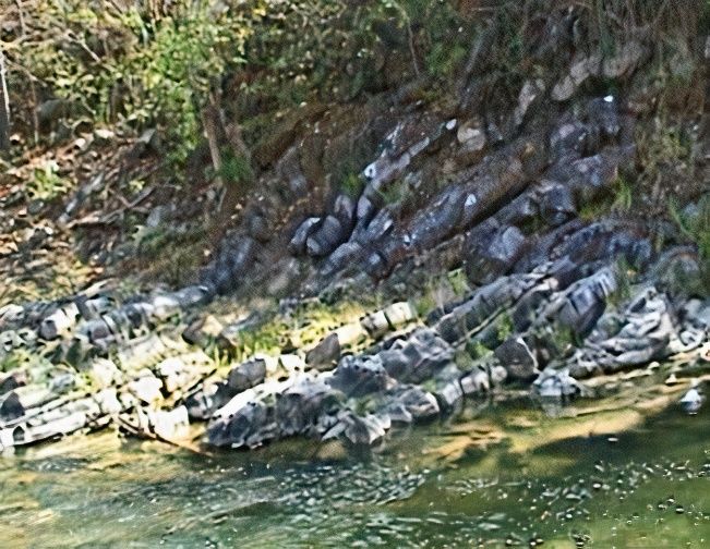
Sustainability 2020, 12, x FOR PEER REVIEW                                                               5 of 24
 Sustainability 2020, 12, 6579                                                                            5 of 24

Progreso. Marine invertebrate fossils such as gastropods, ostracods, and bivalves, which are
associated
 invertebratewith   microfossils
               fossils             of the order
                       such as gastropods,         of the and
                                              ostracods,   foraminifera   and calcareous
                                                                bivalves, which            nanophosiles
                                                                                are associated           of the
                                                                                               with microfossils
Cretaceous
 of the order(Middle    Albian) age,and
               of the foraminifera     are found   in the
                                           calcareous     layers of sedimentary
                                                        nanophosiles              materials
                                                                        of the Cretaceous    [31]. The
                                                                                           (Middle     Puyango
                                                                                                    Albian) age,
river is the limit  between   the  provinces   of El Oro  and   Loja and  represents a great geological
 are found in the layers of sedimentary materials [31]. The Puyango river is the limit between the      fault in
the  East–West    direction. It has  caused  the  folding   of rocks at the gorges of El Chirimoyo,   Cochurco
 provinces of El Oro and Loja and represents a great geological fault in the East–West direction. It has
and  El Limón
 caused          streams
          the folding     [32,33].
                       of rocks  at the gorges of El Chirimoyo, Cochurco and El Limón streams [32,33].

      Figure 2. Geological map of the Las Lajas and Puyango cantons of the provinces of El Oro and Loja
      respectively.
     Figure         Modified
            2. Geological mapfrom  [28].Las Lajas and Puyango cantons of the provinces of El Oro and Loja
                                of the
     respectively. Modified from [28].
3. Materials and Methods
3. Materials   and Methods
      The proposed    methodology for this study comprised three phases (Figure 3): (i) analysis of
 information from the pilot study area, the case of the Puyango Petrified Forest, scientific information
      The proposed methodology for this study comprised three phases (Figure 3): (i) analysis of
 regarding its geological interest, the presentation the paleontological components and their main
information from the pilot study area, the case of the Puyango Petrified Forest, scientific information
 geotouristic sections; (ii) assessment of the heritage site, using the methodology of the Spanish
regarding its geological interest, the presentation the paleontological components and their main
 Inventory of Places of Geological Interest (IELIG, acronym in Spanish) and another proposal by authors
geotouristic sections; (ii) assessment of the heritage site, using the methodology of the Spanish
 to assess its geotouristics potential; and (iii) the results were confirmed with a Strengths, Weaknesses,
Inventory of Places of Geological Interest (IELIG, acronym in Spanish) and another proposal by authors
 Opportunities, and Threats (SWOT) analysis, to assess the heritage site status, and propose sustainable
to assess its geotouristics potential; and (iii) the results were confirmed with a Strengths, Weaknesses,
 development strategies in the SWOT matrix [34].
Opportunities, and Threats (SWOT) analysis, to assess the heritage site status, and propose
sustainable development strategies in the SWOT matrix [34].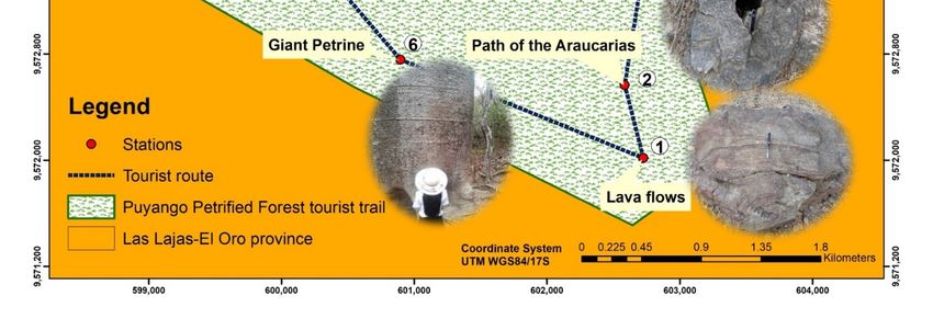
Sustainability 2020, 12, 6579                                                                           6 of 24
 Sustainability 2020, 12, x FOR PEER REVIEW                                                              6 of 24

                             Figure3.3.Flowchart
                            Figure      Flowchartofofthe
                                                      themethodology
                                                          methodologyused
                                                                      usedfor
                                                                           forresearch.
                                                                               research.

3.1. First Phase: Identification of the Pilot Area
 3.1. First Phase: Identification of the Pilot Area
      In the first phase, the researchers realized a technical visit about the outstanding characteristics of
       In the first phase, the researchers realized a technical visit about the outstanding characteristics
the studied forest, which was carried out with a tourist guide and some national tourists. The route
 of the studied forest, which was carried out with a tourist guide and some national tourists. The route
of the place consists of six stations of great geological and paleontological interest, in addition to
 of the place consists of six stations of great geological and paleontological interest, in addition to the
the collection of historical and scientific information carried out in the sector [26,29,30] through the
 collection of historical and scientific information carried out in the sector [26,29,30] through the
configuration of a database in scientific publications, works outreach, project reporting and data
 configuration of a database in scientific publications, works outreach, project reporting and data
collection through expert interviews as the basis for further evaluation. This route included the use of
 collection through expert interviews as the basis for further evaluation. This route included the use
database in Geographic Information Systems (GIS) to obtain a map of the tourist route recorded in the
 of database in Geographic Information Systems (GIS) to obtain a map of the tourist route recorded in
Puyango forest.
 the Puyango forest.
      Finally, this phase included the description geological, paleontological aspects and relevant
       Finally, this phase included the description geological, paleontological aspects and relevant
observations of the geotouristics potential of seventeen possible geosites. We also presented its
 observations of the geotouristics potential of seventeen possible geosites. We also presented its
paleontological components that give the forest an important scientific interest for geologists and
 paleontological components that give the forest an important scientific interest for geologists and
paleontologists. Much of its evidence was recorded in fossils such as petrified wood samples and
 paleontologists. Much of its evidence was recorded in fossils such as petrified wood samples and
remains of mollusc shell moulds that were found in some streams belonging to the provinces of El
 remains of mollusc shell moulds that were found in some streams belonging to the provinces of El
Oro and Loja, giving great geotouristics interest to the forest. Besides that, a stratigraphic column
 Oro and Loja, giving great geotouristics interest to the forest. Besides that, a stratigraphic column
belonging to the Las Concreciones stream was described, and finally, it showed pictures of marine
 belonging to the Las Concreciones stream was described, and finally, it showed pictures of marine
fossil invertebrates of the classes of pelecypod and cephalopod molluscs.
 fossil invertebrates of the classes of pelecypod and cephalopod molluscs.
3.2. Second Phase: Quantitative and Qualitative Evaluation
 3.2. Second Phase: Quantitative and Qualitative Evaluation
      Moreover, the applied methodology comprises two factors: (1) intrinsic value of the Site of
       Moreover, the applied methodology comprises two factors: (1) intrinsic value of the Site of
Geological Interest (LIG, acronym in Spanish), highlighting the geological aspects, and (2) use-value
 Geological Interest (LIG, acronym in Spanish), highlighting the geological aspects, and (2) use-value of
of the LIG. Therefore, with the collaboration of paleontologist Nelson Jiménez and archaeologist
 the LIG. Therefore, with the collaboration of paleontologist Nelson Jiménez and archaeologist Jorge
Jorge Marcos, experts who evaluate the scientific, didactic and touristic premises value, surveys are
 Marcos, experts who evaluate the scientific, didactic and touristic premises value, surveys are
collected. The experts assign weights to each premise of the methodology developed in [18] (Table 1),
 collected. The experts assign weights to each premise of the methodology developed in [18] (Table
where the degrees of Scientific interest (Si), Didactic interest (Di) and Touristic interest (Ti) are obtained.
 1), where the degrees of Scientific interest (Si), Didactic interest (Di) and Touristic interest (Ti) are
The scores of each parameter vary from 0, 1, 2 and 4, where 0 is the lowest score and 4 the highest,
 obtained. The scores of each parameter vary from 0, 1, 2 and 4, where 0 is the lowest score and 4 the
scores that are multiplied by the weight of the individual interests given in the methodology (Table 1).
 highest, scores that are multiplied by the weight of the individual interests given in the methodology
 (Table 1).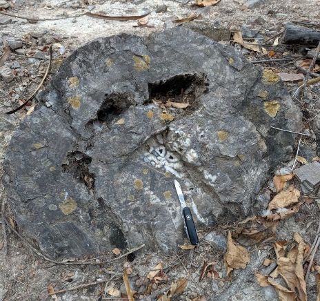
Sustainability 2020, 12, 6579                                                                                    7 of 24

      Table 1. Indicators and weights used for the quantitative assessment of Sites of Geological Interest
      (LIGs). Modified from [18].

                                                  IELIG Methodology
     Scientific Weight (Sw), Didactic Weight (Dw), Tourist Weight (Tv), Fragility Weight (Fw) and
     Vulnerability due to Anthropogenic Threats Weight (Vw)
                                                                                                 Weight
                   Indicators/Parameters                         Punctuation
                                                                                    Sw     Dw     Tw      Fw    Vw
                    Representativeness                                              30     5
              Prototype location character                                          10     5
      Degree of scientific knowledge of the place                                   15
                   State of conservation                                            10      5
                 Observation conditions                                             10      5      5
                           Rarity                                                   15      5
                   Geological diversity                                             10     10
                     Didactic content                                                      20
                 Logistics infrastructure                                                  15       5
                        Accessibility                                                      15      10
     Association with other elements of the natural
                                                                                            5      5
                 and/or cultural heritage
                 Magnificence or beauty                                                     5      20
       Population density (potential aggression)                     0–4                    5       5           5
      Proximity to recreational areas (immediate
                                                                                                   5            5
                    potential demand)
     Informative content/Informative use detected                                                  15
     Potential to carry out touristic and recreational
                                                                                                   5
                          activities
              Socioeconomic environment                                                            10
                          LIG size                                                                 15     40
                 Vulnerability to plunder                                                                 30
                      Natural threats                                                                     30
            Proximity to anthropic activities
                                                                                                                20
                      (infrastructure)
                    Interest for mining                                                                          15
                  Site protection regime                                                                        15
             Physical or indirect protection                                                                    15
            Accessibility (potential assault)                                                                   15
                 Place ownership regime                                                                          10
                            Total                                                   100    100    100     100   100

     Then, the total provides the value of Si, Di and Ti. If the LIG exceeds 266 points, it is considered
a place of “Very high” interest. Hence, the scores between 134 and 266 will be of “High” interest,
and those lower than 134 points will be considered to be of “Medium” interest. The following equations
are defined for the value of each interest:
                                         n parameters
                                             X
                                  Si =                  Puntuation × Scienti f ic weight                              (1)
                                         i=parameter

                                          n parameters
                                              X
                                  Di =                    Puntuation × Didactic weight                                (2)
                                           i=parameter

                                           n parameters
                                               X
                                   Ti =                   Puntuation × Tourist weight                                 (3)
                                           i=parameter
Sustainability 2020, 12, 6579                                                                            8 of 24

     Furthermore, a qualitative evaluation about conservation of the site is achieved, where the
Susceptibility of Degradation (SD) of the site is evaluated based on the Fragility (F) and the vulnerability
due to anthropogenic Threats (T). With the SD, researchers can obtain the Protection Priority (PP) for Si,
Di, Ti of the LIG and rank the interests according to the PP value in its different vertices: scientific (SPP),
didactic (DPP), touristic-recreation (TPP), and global (PP). Taking the threshold of the pilot project in
the Iberian Cordillera [18] for a given value of the SD as reference, if the value is higher than 26, the PP
degree “High” of the LIG. If the SD is equal to 26, the PP degree is “Medium”. The “Medium-high”
and “Medium-low” PP will be around 8. To obtain the values of fragility (F) and threat (T) that allow
prioritizing and monitoring of the conservation status, where it is susceptible to degradation, and to
quantify the priorities SPP, DPP, TPP, and PP, the researchers used the following equations:

                                     n parameters
                                         X
                                F=                  Puntuation × Fragility weight                           (4)
                                     i=parameter

                                      n parameters
                                          X
                                 T=                  Puntuation × Threat weight                             (5)
                                      i=parameter

                                         SD = ((F × T ) × 1/400)                                            (6)

                                       SPP = Si2 × SD × 1/4002                                              (7)

                                       DPP = Di2 × SD × 1/4002                                              (8)

                                       TPP = Ti2 × SD × 1/4002                                              (9)

                                 PP = [(Si + Di + Ti)/3]2 × SD × 1/4002                                    (10)

     Moreover, the authors include a completed form of the proposed methodology that includes the
Scientific, Didactic, Tourist and Popular Interest factors with Accessibility, Sensitivity and Conservation
status (SDTPI-ASC), considering the 17 LIGs of relevant geological-paleontological importance.
This approach strengthens the evaluated geological heritage. For this purpose, the interest categories
are divided into Scientific interest (Si), Didactic interest (Di) and Touristic interest (Ti) and Popularization
interest (Pi), with its sections on accessibility to the place, sensitivity to plunder and current conservation
status, as a basis for future studies.

3.3. Third Phase: Strategies
     In this phase, based on expert judgment, the SWOT matrix configuration was done,
with experiences from technical visits and studies in the Puyango Petrified Forest (BPP). This matrix
allows establishing opportunities for geotourism development, identifying strengths, weaknesses and
threats. The particular singularity of the territory in its geological and paleontological heritage has been
highlighted, with a high interest for national and international geologists interested in investigating
the geological record of the place, the scientific, educational and recreational use to strengthen the
local economy.
     There is a high fossil content, pleated structures, sedimentary, volcanic, metamorphic rocks
with a natural, integral and biodiverse perspective, with samples of petrified trunks, pelecypods,
macrofossils and ammonites. In the analysis of experts, the limitations or problems of the geosites are
also considered, to turn them into new strategies for local development.
     A SWOT analysis was carried out to assess the conservation status of the heritage site and to
propose sustainable development strategies in a SWOT matrix [34], where the Puyango geopark project
has great potential to promote the development of geotourism in the zone.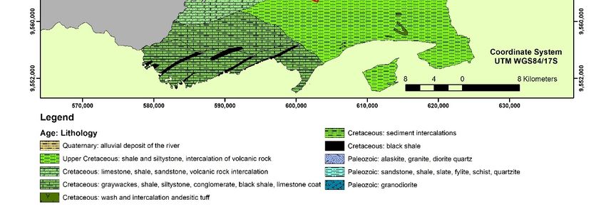
macrofossils and ammonites. In the analysis of experts, the limitations or problems of the geosites are
also considered, to turn them into new strategies for local development.
      A SWOT analysis was carried out to assess the conservation status of the heritage site and to
propose sustainable development strategies in a SWOT matrix [34], where the Puyango geopark
project has2020,
Sustainability great
                   12,potential
                       6579     to promote the development of geotourism in the zone.            9 of 24

4. Results
4. Results
4.1. Identification of the Pilot Area
4.1. Identification of the Pilot Area
      The identification of the pilot area includes the visit of the tourist trail carried out in the Puyango
      The identification of the pilot area includes the visit of the tourist trail carried out in the Puyango
Petrified Forest (PPF), in the province of El Oro. This guided route lasts approximately 45 min and
Petrified Forest (PPF), in the province of El Oro. This guided route lasts approximately 45 min and
observation stops are made at the stations: (1) Lava flows, (2) Path of the Araucarias, that is a genus
observation stops are made at the stations: (1) Lava flows, (2) Path of the Araucarias, that is a genus of
of evergreen coniferous trees in the family Araucariaceae, (3) Deposit of petrified logs, (4)
evergreen coniferous trees in the family Araucariaceae, (3) Deposit of petrified logs, (4) Carboniferous
Carboniferous zones, (5) Path of the Giant, and (6) Giant Petrine (Figure 4).
zones, (5) Path of the Giant, and (6) Giant Petrine (Figure 4).

                 Figure 4. Map of the Puyango Petrified Forest tourist trail, El Oro Province [28].

     For a betterFigure  4. Mapreference
                    scientific   of the Puyango
                                            about Petrified Forest
                                                   LIGs, Table     tourist trail,
                                                                 2 details        El Oro Province
                                                                           the important           [28]. aspects such
                                                                                              geological
as geological structures and type of rocks found in the geosite, as well as paleontological aspects that
standFor
      outa for
            better
               theirscientific reference
                      fossil content,   theabout   LIGs,
                                             type of      Table 2 details
                                                     fossilization  and the the  important
                                                                              number          geological
                                                                                         of petrified    aspects
                                                                                                      trunks foundsuch
                                                                                                                     in
as geological  structures    and  type   of rocks found   in the
each geosite which makes it an excellent geotouristic remnant.   geosite,  as well   as paleontological   aspects  that
standSome
      out forof their  fossilmentioned
                the LIGs      content, the in type
                                              Tableof2 fossilization
                                                       belong to theand    the number
                                                                       province      of El of petrified
                                                                                           Oro,  such astrunks  found
                                                                                                          the streams
in each geosite   which   makes    it an  excellent geotouristic   remnant.
Sábalos, Las Palmas, El Tigre, El Guineo, El Gringo, Quemazón and in the province of Loja are
the El Chirimoyo, Cochurco, El Limón, Las Concreciones and Tunima (Figure 5). In the Cochurco,
                     Table 2. Geological
El Chirimoyo and Las Concreciones        and remains
                                   streams,  paleontological aspects
                                                      of mollusk     of the
                                                                  shell     LIGs.such as pelecypods and
                                                                         molds
ammonites have been found in the limestones [26].      Paleontological
 N°          LIGs        Geological Aspects                                          Observations
                                                           Aspects
       PPF Tourist    Volcano-sedimentary          It contains abundant        It is a guided tourist
  1
       trail          rocks.                       remains of well-            route in the tropical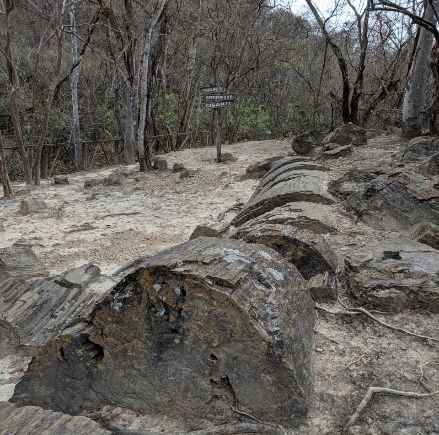
Sustainability 2020, 12, 6579 10 of 24
Table 2. Geological and paleontological aspects of the LIGs.
N◦ LIGs Geological Aspects Paleontological Aspects Observations
It contains abundant It is a guided tourist route
1 PPF Tourist trail Volcano-sedimentary rocks. remains of well-preserved in the tropical dry forest
petrified trunks. (fauna and flora).
Geological domain: Alamor,
Lancones Basin. At the base, The trunks are well
some ortho-quartzites and preserved, practically
conglomerates rest intact of large dimensions,
It contains abundant
discordantly on the the only fossil specimens
remains of petrified trunks
2 Sábalos stream Amotape, Tahuin massif. resulting from the
corresponding to
Black marl, massive layers of fossilization process of
Araucariaceas.
limestone and banded black petrification, product of
shales, clays, siltstones and the replacement of organic
sandstones with lava and matter by silica.
sedimentary volcano rocks.
Remains of fossil roots
(charred), remains of A petrified trunk of
Volcanic materials and
petrified trunks. Fossil Araucariaceas well
3 Cochurco stream sedimentary limestones
invertebrates, present as preserved, in a significant
and shales.
internal and vertical position.
external moulds.
Remains of fossil
invertebrates: Pelecypods,
Geological deformations Inoceramus and Ammonites;
Invertebrate marine fauna
4 Chirimoyo stream (folds) in sedimentary rocks and microfossils: planktonic
is very frequent.
represented by clay. and benthic foraminifera,
calcareous nanofossils and
Palinomorphs.
Petrified (carbonized)
trunks, in which the
cellulose of the trees was
Geological deformations,
Petrified trunks well transformed into
fold (anticline) in
preserved. Invertebrate anthracite due to the loss
5 El Limón stream volcano-sedimentary rocks.
fossils: foraminifera and of methane, water and
Calcareous rocks
calcareous nanofossils. carbon dioxide.
(Coquina type).
This geosite has a potential
area to recreation (crystal
clear lagoon).
It shows stratifications by Fossil invertebrates: a
the alternative deposit of phylum of molluscs, bivalves
6 El Guineo stream Pelecypod prints.
sediments of different and ammonites and
composition. petrified trunks.
Fossil invertebrates: a Vegetable fossil remains,
Volcano-sedimentary rocks,
7 Gringo Beach phylum of molluscs, from fossilization
limestones, shales and clays.
bivalves and ammonites. processes (carbonization).
Limestone outcrop
associated with a core of Ammonite concretions.
A unique geosite: can be
Ammonites. Shales, marls Molluscs, foraminifera and
8 Las Concreciones stream shown calcareous
and thin layers of clays. The calcareous nanofossils and
concretions.
limestones inside have ostracods.
pyrite.
Remains of allochthonous Little diversity of petrified
9 Las Palmas stream Volcano-sedimentary rocks.
petrified trunks. trunks.
Geological deformations,
Appears a few remains of Fossilization processes
10 Quemazón stream folding and thrust in
petrified (charred) trunks. (carbonization).
limestone rocks.
Petrified trunk in
Volcano-clastic rocks, with volcano-clastic rocks with
Petrified trunks
11 Tunima stream levels containing a diameter smaller than
well preserved.
petrified trunks. found in Sábalos and
Chocurco streams.
Geographical reference
whose cause has an altitude
of 200 m.a.s.l, is the water Appears remains of
Allochthonous
12 Puyango River course axis of importance for the petrified trunks and
petrified trunks.
ENE-WSW direction fossil invertebrates.
according to the structural
limits of the sector.Sustainability 2020, 12, 6579 11 of 24
Table 2. Cont.
N◦ LIGs Geological Aspects Paleontological Aspects Observations
Allochthonous
13 Puyango, Alamor trail None. None.
petrified trunks.
Volcano-sedimentary Vegetable fossil remains The only geosite with a
sediments reddish color due (fossilized leaf) by petrified leaf specimen in
14 El Tigre stream
to the presence of fossilization processes the fossilization process
iron oxides. (carbonization). (carbonization).
Sustainability 2020, 12, x FOR PEER REVIEW 12 of 24
Geological deformations
Metamorphic deformations. Geosite without
15 La Libertad fold due to
Anticline fold. paleontological remains.
compressive stresses.
paleontological
Appears deposits of visible
Sedimentary rocks
material of sedimentary information. Recreational tourist place
16 Playón Las Pailas carbonated, with remains of
rocks along the river bed in for organized activities.
invertebrates.
the dry season.
Some of the LIGs mentioned in Table 2 belong toPetrified
Exists geological
the province of El Oro, such as the streams
trunks, fossils.
Sábalos,
17
Las Palmas, El Tigre,
PPF Interpretation left
El Guineo,
information El Gringo,
(samples of Quemazón and
Recreation area, in the province
location of Loja are the El
Disclosure area.
rocks and maps of the main gorges,
Chirimoyo, Cochurco, El Limón, Las Concreciones and
calcareous concretions).
Tunima (Figure 5). In the Cochurco, El
paleontological information.
Chirimoyo and Las Concreciones streams, remains of mollusk shell molds such as pelecypods and
ammonites have been found in the limestones [26].
(a) (b)
(c) (d)
Figure 5. Streams of the province of El Oro (a) Sábalos, (b) Cochurco, (c) Las Palmas and (d)
Figure 5. Streams of the province of El Oro (a) Sábalos, (b) Cochurco, (c) Las Palmas and (d) Las
Las Concreciones.
Concreciones.
Moreover, a stratigraphic column of the Las Concreciones stream is shown (Figure 6) as a result
of theMoreover,
scientific aresearch
stratigraphic column
carried of the
out in. TheLas Concreciones
stream adopted stream is shown
that name (Figure
because 6) beginning
at the as a result
of the scientific research carried out in. The stream adopted that name because at the beginning
of the stream, precisely upstream, there are concretions of limestone rolled from the upper part, of
the stream, precisely upstream, there are concretions of limestone rolled from the upper part, whose
outcrop is made of sedimentary material. On the shales, limestones, marls and thin layers of clay are
observed. Limestone concretions of 0.80 m in diameter are observed in the rock with a light gray hue.
The limestones are crystalline with pyrite as a mineral. In addition, the concretion of two Ammonite
molds lie, and a large limestone outcrop approximately 7 m thick stands out at the end of the stationSustainability 2020, 12, 6579 12 of 24
whose outcrop is made of sedimentary material. On the shales, limestones, marls and thin layers of
clay are observed. Limestone concretions of 0.80 m in diameter are observed in the rock with a light
gray hue. The limestones are crystalline with pyrite as a mineral. In addition, the concretion of two
Ammonite molds lie, and a large limestone outcrop approximately 7 m thick stands out at the end of
the station 2020,
Sustainability [27]. 12, x FOR PEER REVIEW 13 of 24
Figure 6.
Figure 6. Stratigraphic
Stratigraphic Column of the
Column of the Las
Las Concreciones
Concreciones stream.
stream. Modified from [29].
Modified from [29].
The fossil invertebrates are marine and belong to the the pelecypods
pelecypods and cephalopod
cephalopod classes of
mollusks (Figure
mollusks (Figure7).
7).The
Thecephalopod
cephalopodclass
class
is is represented
represented byby ammonoids
ammonoids represented
represented by internal
by the the internal
and
and external molds as well as petrified shells in the Cochurco, El Chirimoyo, El Limón,
external molds as well as petrified shells in the Cochurco, El Chirimoyo, El Limón, Las Concreciones, Las
Concreciones,
and and El Guineo
El Guineo streams. streams.
The internal Theofinternal
molds mollusksmolds of mollusks
with Nucula with Nucula
spp, Inoceramus spp, Inoceramus
concentricus, Astarte
concentricus,
spp Astarte spp
and Heterodontido and
(See Heterodontido (See
Supplementary supplementary
Figures S1–S4) [26]. Figures S1, S2, S3, S4) [26].Figure 6. Stratigraphic Column of the Las Concreciones stream. Modified from [29].
The fossil invertebrates are marine and belong to the pelecypods and cephalopod classes of
mollusks (Figure 7). The cephalopod class is represented by ammonoids represented by the internal
and external molds as well as petrified shells in the Cochurco, El Chirimoyo, El Limón, Las
Sustainability 2020, 12, 6579 13 of 24
Concreciones, and El Guineo streams. The internal molds of mollusks with Nucula spp, Inoceramus
concentricus, Astarte spp and Heterodontido (See supplementary Figures S1, S2, S3, S4) [26].
Sustainability 2020, 12, x FOR PEER REVIEW 16 of 24
Figure 7.
Figure 7. Macro-fossils
Macro-fossils in inthe
theprovince
provinceofofLoja:
Loja:(a)
(a)Pelecipodo
Pelecipodo heterodontido,
heterodontido, (b)(b) Ostrea
Ostrea sp.,sp., (c) Astarte
(c) Astarte sp.,
sp., Peltoceras
(d) Peltoceras sp.,Fragment
(e) Fragment of return
The
of Ammonitido
town is located at the entrance to the forest
(d) sp., (e) of return of Ammonitido and and (f) Schoenbachia
(f) Schoenbachia sp. sp.
tourist complex that belongs to the province of El
Population density
4.2. Evaluation Oro, Las Lajas canton. It has an economically
(potential aggression)
active population of approximately 200 people,
The results of phase ii with the scientific, didactic and touristic interests are presented according
mostly farmers [26].
to the IELIG methodology with its justification in Table 3.
To obtain the value of each item of interest, Equations (1)–(3) were used. Results reveal that
To obtain the value of each item of interest, Equations (1)–(3) were used. Results reveal that the
the Puyango Petrified Forest presents a “Very high” and “High” global degree of interest in the
Puyango Petrified Forest presents a “Very high” and “High” global degree of interest in the Scientific
Scientific (Si), Didactic (Di) and Touristic (Ti) aspects. Although some of them have a “Middle” public
(Si), Didactic (Di) and Touristic (Ti) aspects. Although some of them have a “Middle” public interest
interest (Figure 8), the reason is that the lack of strategies that promote the geodiversity of the area
(Figure 8), the reason is that the lack of strategies that promote the geodiversity of the area through
through geotourism.
geotourism.
Figure
Figure 8. Assessment of
8. Assessment of the
the degree
degree of
of geological
geological interest
interest of
of the
the LIGs
LIGs in
in the
the Puyango Petrified Forest
Puyango Petrified Forest
according to IELIG.
according to IELIG.
The results of the applied evaluation of the IELIG methodology are represented in Table 4,
noting that there are four LIGs with Geological Interest (IG) “Very High”, nine of interest “High” and
four “Medium”, reflecting the great relevance of the Puyango Petrified Forest. The Global Protection
Priority (PPG) values are also shown, finding most of the LIGs with the rating of “Medium-low”.Sustainability 2020, 12, 6579 14 of 24
Table 3. Description of the main indicators evaluated by the IELIG methodology.
Value Indicators/Parameters Description
The Puyango Petrified Forest (PPF) is a
source of knowledge and well-being and
it is the unique place with the best
paleontological exposure in Ecuador. The
area shows a sequence of
Representativeness volcano-sediment from the Cretaceous age
(Albian-Middle). A collection of petrified
trunks, fossilized leaves of common
gymnosperms and remains of mollusk
shell molds of the Southern Cretaceous
have been found in PPF deposits.
PPF is a site of geological interest and a
good example of a paleontological deposit,
Prototype location
where specimens of petrified trunks and
character
other allochthonous from Aptian-Middle
and Jurassic-Cretaceous are found in situ.
There are several works published in
national and international journals
performed by geoscientists and theses
Degree of scientific
carried out by students and professionals
knowledge of the place
on geological, paleontological,
archaeological, botanical, cultural,
economic and tourism topics.
PPF presents a regular state of
conservation. Some deteriorated areas
prevent the observation of geological
State of conservation
characteristics (landslides). Some
information panels are
Scientific value partially deteriorated.
The observation of several silicified trunks
of Araucariaceas and Metapodocarpoxylon
specimens, marine invertebrate fossils of
the phylum Mollusca of the pelecypods
class and cephalopod (ammonoids)
possible. The fossilized flora corresponds
Observation conditions
to the subphylum of the mid-Mesozoic
gymnosperms of the Zamites, Dioonites,
Nilssonia, Otozamites, Podozamites, Carpites,
and other genera. It is also a dry-tropical
forest ecosystem that preserves species
(fauna and flora) existing today.
The petrified trunks of Puyango represent
one of the largest collections of petrified
Rarity wood in Ecuador and probably in the
world. The site has unique characteristics
from the Cretaceous Period.
The paleontological aspect stands out as
the main geological interest, followed by
the stratigraphic, sedimentological,
Geological diversity structural and geological history.
Secondary features are the
historical/archaeological, biodiversity,
cultural and landscape.Sustainability 2020, 12, 6579 15 of 24
Table 3. Cont.
Value Indicators/Parameters Description
Educational visits and excursions from
schools, colleges, and universities take
Didactic content place considering the protection of the
geological-paleontological heritage of the
place.
It lacks nearby accommodations and
restaurants for tourist groups, but it has
Logistics infrastructure
an interpretation and information left for
tourists.
Using a national highway there is the
access
Guayaquil-Machala-Arenillas-Puyango
with a 276 km route. From Huaquillas
(border with Peru), there are 62 km.
Accessibility
Another access road goes from
Loja-Veracruz- Catacocha’s city through a
state highgway and then El
Empalme-Celica-Alamor-Puyango with a
Educational potential distance of 213 km [26].
and touristic use
Association with other Numerous archaeological remains
elements of the natural (petroglyphs) found in different parts of
and/or cultural heritage the Puyango canton.
Landscape, river course, remains of plant
Magnificence or beauty fossils and invertebrates as evidence of
ancient times.
Informative
Limited and without a tourist information
content/Informative use
department.
detected
Potential to carry out
It has touristic trails, fossil deposits
touristic and recreational
and streams.
activities
Proximity to recreational
There is a camping area less than 500 m
areas (immediate
from the forest.
potential demand)
The most common economic activities are
Socioeconomic
the short cycle crops sowing and coffee,
environment
cattle and pig raising.
LIG size Area of 2.6 ha. with 17 LIGs.
A paleontological site of great value, with
Vulnerability to plunder
numerous specimens and easy plunder.
Fragility
Possible landslides, flooding of rivers,
Natural threats weakening of the soil and climatic
variations due to severe droughts.Sustainability 2020, 12, 6579 16 of 24
Sustainability 2020, 12, x FOR PEER REVIEW 17 of 24
Table 3. Cont.
El Limón
Value Medium-
5 335 215 Indicators/Parameters
260 270 High 0 0 0Description
0 0
stream low
El Guineo Proximity to anthropic Medium-
6 185 150activities
175 (infrastructure)
170 High 0Place not
0 threatened.
0 0 0
stream low
Interest for mining No mining interest in the area. Medium-
7 Gringo Beach 240 165 175 193 High 9.75 3.15 1.66 1.87 2.27
Cultural Heritage, Ordinance for the low
Las Declaration of the Bi-provincial Protected
Medium-
8 Concreciones 270 175Site255 protection
233 regime
High 5.63
Area,2.56 1.08
in the Category 2.29 1.91
of Ecological low
stream Conservation Area.
Las Palmas Medium-
9 110 80Physical
145 or indirect
112 Medium 9 0.68 0.36 1.18 0.70
stream Protected area with access to tourists.low
Vulnerability due to protection
Quemazón Medium-
10 anthropogenic threats305 170Accessibility
210 228 High 0It is directly
0 0
accessible 0 through0 unpaved
stream low
Tunima (potential assault) and passable track for tourism. Medium-
11 320 225 235 260 High 8.25 5.28 2.61 2.85 3.49
stream Location in restricted access areas low
Place ownership regime
Puyango declared as natural heritage. Medium-
12 110 90 140 113 Medium 82.50 6.24 4.18 10.11 6.62
River course The town is located at the entrance tolow the
Puyango- forest6.24
tourist4.18
complex that belongsMedium-
to the
13 110 90 140 113 Medium 82.50 10.11 6.62
Alamor trail Population density province of El Oro, Las Lajas canton. low
El Tigre (potential aggression) It has an economically active populationMedium-
14 320 225 235 260 High 8.25 5.28 2.61 2.85 3.49
stream of approximately 200 people, mostly low
La Libertad farmers [26]. Medium-
15 110 80 145 112 Medium 9 0.68 0.36 1.18 0.70
fold low
Playón Las Medium-
16
The results 240 165
of the applied 175 193
evaluation of theHigh 9.75
IELIG methodology3.15 are 1.66 1.87
represented 2.27
in Tablelow
4, noting
Pailas
that there arePPFfour LIGs with Geological Interest (IG) “Very High”, nine of interest “High” and four
Very
“Medium”, reflecting the380
17 Interpretation great275
relevance
230 295 of the Puyango Petrified
50 Forest.
45.13 The 16.53
23.63 Global27.20
Protection Priority
High
High
(PPG) values are also shown, finding most of the LIGs with the rating of “Medium-low”.
Center
The fossilized trunks resulted from the fossilization process, especially petrification by replacing
organicThe fossilized
matter such trunks resulted
as cellulose from
and the fossilization
limenine with silicaprocess, especially
[33,35]. petrification byimportance
The paleontological replacing
with the highest concentration of logs has been found in the old Puyango-Alamor highway with
organic matter such as cellulose and limenine with silica [33,35]. The paleontological importance and El
the highest
Chirimoyo, concentration
El Limón, of logs has
and Cochurco been where
streams, found specimens
in the oldofPuyango-Alamor
logs of up to 26 mhighway
long byand El in
2.2 m
Chirimoyo, El Limón, and Cochurco streams, where specimens of logs of up to 26 m long by 2.2 m in
diameter have been located (Figure 9).
diameter have been located (Figure 9).
(a) (b) (c)
Figure9.9.(a,b)
Figure (a,b)Logs
Logspetrified
petrified with
with silica. (c)
(c) Giant
Giantpetrified
petrifiedtrunk.
trunk.
From the point of view of the conservation of LIG, it is necessary to determine the susceptibility
of degradation. This analysis is performed through the fragility and natural threats components.
Hence, mitigation actions can be taken to reduce as far as possible the vulnerability of the geosite and
the damage caused by an event and anthropic threats identified in the sector. The data obtained as a
result of the implementation of Equations (6)–(10) were presented in Table 4. With this values,
Protection priorities “Medium-low” were identified for each of the protection priority parametersSustainability 2020, 12, 6579 17 of 24
Table 4. Quantitative assessment of parameters Scientific interest (Si), Didactic interest (Di), Touristic
interest (Ti), Total Average Weight (Taw), Degree of geological interest (GI), Susceptibility of Degradation
(SD), Scientific Protection Priority (SPP), Didactic Protection Priority (DPP), Touristic Protection Priority
(TPP), Protection Priority (PP) and Global Protection Priority (PPG), according to the IELIG methodology.
N◦ LIGs Si Di Ti Taw GI SD SPP DPP TPP PP PPG
PPF Touristic
1 380 275 230 295 Very High 50 45.13 23.63 16.53 27.20 High
trail
2 Sábalos stream 360 250 285 298 Very High 4.50 3.65 1.76 2.28 2.50 Medium-low
Cochurco
3 320 225 235 260 High 8.25 5.28 2.61 2.85 3.49 Medium-low
stream
Chirimoyo
4 330 215 225 257 High 18 12.25 5.20 5.69 7.41 Medium-low
stream
El Limón
5 335 215 260 270 High 0 0 0 0 0 Medium-low
stream
El Guineo
6 185 150 175 170 High 0 0 0 0 0 Medium-low
stream
7 Gringo Beach 240 165 175 193 High 9.75 3.15 1.66 1.87 2.27 Medium-low
Las
8 Concreciones 270 175 255 233 High 5.63 2.56 1.08 2.29 1.91 Medium-low
stream
Las Palmas
9 110 80 145 112 Medium 9 0.68 0.36 1.18 0.70 Medium-low
stream
Quemazón
10 305 170 210 228 High 0 0 0 0 0 Medium-low
stream
11 Tunima stream 320 225 235 260 High 8.25 5.28 2.61 2.85 3.49 Medium-low
Puyango River
12 110 90 140 113 Medium 82.50 6.24 4.18 10.11 6.62 Medium-low
course
Puyango-Alamor
13 110 90 140 113 Medium 82.50 6.24 4.18 10.11 6.62 Medium-low
trail
14 El Tigre stream 320 225 235 260 High 8.25 5.28 2.61 2.85 3.49 Medium-low
La Libertad
15 110 80 145 112 Medium 9 0.68 0.36 1.18 0.70 Medium-low
fold
Playón Las
16 240 165 175 193 High 9.75 3.15 1.66 1.87 2.27 Medium-low
Pailas
PPF
17 Interpretation 380 275 230 295 Very High 50 45.13 23.63 16.53 27.20 High
Center
From the point of view of the conservation of LIG, it is necessary to determine the susceptibility
of degradation. This analysis is performed through the fragility and natural threats components.
Hence, mitigation actions can be taken to reduce as far as possible the vulnerability of the geosite
and the damage caused by an event and anthropic threats identified in the sector. The data obtained
as a result of the implementation of Equations (6)–(10) were presented in Table 4. With this values,
Protection priorities “Medium-low” were identified for each of the protection priority parameters SPP,
DPP, TPP and PP, which depend on the value calculated in the LIG Degradation Susceptibility (SD),
this parameter is calculated independently of the others. The Figure 10 shows the sections of SPP, DPP
and TPP with a global Protection Priority (PP) “Medium-low”, except for two LIGs with a PP “High”.Sustainability 2020, 12, x FOR PEER REVIEW 18 of 24
SPP, DPP, TPP and PP, which depend on the value calculated in the LIG Degradation Susceptibility
(SD), this parameter is calculated independently of the others. The Figure 10 shows the sections of
SPP, DPP and
Sustainability 2020,TPP with a global Protection Priority (PP) “Medium-low”, except for two LIGs with
12, 6579 a
18 of 24
PP “High”.
Figure 10. Assessment of the Protection Priority of the LIGs.
Figure 10. Assessment of the Protection Priority of the LIGs.
Additionally, all 17 LIGs which strengthen the entire system of geological-paleontological heritage
Additionally, all 17 LIGs which strengthen the entire system of geological-paleontological
in this sector are marked in the PPF. With the application of the Scientific, Didactic, Tourist and Popular
heritage in this sector are marked in the PPF. With the application of the Scientific, Didactic, Tourist
Interest with Accessibility, Sensitivity and Conservation Status methodology (SDTPI-ASC), the authors
and Popular Interest with Accessibility, Sensitivity and Conservation Status methodology (SDTPI-
identified the different types of interest: Scientific (Si), Didactic (Di), Tourist (Ti) and Popularization
ASC), the authors identified the different types of interest: Scientific (Si), Didactic (Di), Tourist (Ti)
(Pi). The SDTPI-ASC was supported by the criteria of experts Nelson Jiménez, Jorge Marcos and Irina
and Popularization (Pi). The SDTPI-ASC was supported by the criteria of experts Nelson Jiménez,
Xomchuk, based on [26]; Table 5 illustrates the SDTPI-ASC methodology.
Jorge Marcos and Irina Xomchuk, based on [26]; Table 5 illustrates the SDTPI-ASC methodology.
Table 5. Referential assessment of the LIGs by the SDTPI-ASC methodology evaluated by experts in
Table
the 5. Referential
Puyango assessment
Petrified of the
Forest. It has LIGsofby
a type the SDTPI-ASC
interest (3). methodology evaluated by experts in
the Puyango Petrified Forest. It has a type of interest (✓).
UTM Type of Interest Conservation
N◦ LIGs UTM Type of interest Accessibility Sensitivity Conservation
N° LIGs Coordinates Si Di Ti Accessibility Sensitivity
Pi Status
Coordinates Si Di Ti Pi Status
PPF Tourist 601735E,
1 601735E, 3 3 3 3 Good Average Good
1 trail trail
PPF Tourist 9560324S ✓ ✓ ✓ ✓ Good Average Good
9560324S
602734E,
2 Sábalos stream 602734E,
9570326S
3 3 3 3 Good Average Good
2 Sábalos stream ✓ ✓ ✓ ✓ Good Average Good
9570326S
Cochurco 606966E,
3 Cochurco 606966E, 3 3 3 3 Good Poor Good
3 stream 9572143S ✓ ✓ ✓ ✓ Good Poor Good
stream 9572143S
Chirimoyo 603047E, Below
4 Chirimoyo 603047E, 3 3 3 Below Poor Good
4 stream 9563869S ✓ ✓ ✓ average Poor Good
stream 9563869S average
El Limón 606437E, Below Below
5 606437E, 3 3 3 3 Below Poor
5 stream
El Limón stream 9571676S ✓ ✓ ✓ ✓ average Poor average
Below average
El Guineo
9571676S
598773E,
average
Below Below
6 El Guineo 598773E, 3 3 Below Poor
stream 9567082S average average
6 ✓ ✓ Poor Below average
stream 9567082S
600022E, average
Below
7 Gringo Beach 3 3 3 Poor Good
600022E,
9573244S Below
average
7 Gringo Beach ✓ ✓ ✓ Poor Good
Las 9573244S average
602810E, Below
8 Concreciones 3 3 Poor Poor
9570930S average
streamYou can also read