Reassessing the lithosphere: SeisDARE, an open-access seismic data repository - ESSD
←
→
Page content transcription
If your browser does not render page correctly, please read the page content below
Earth Syst. Sci. Data, 13, 1053–1071, 2021
https://doi.org/10.5194/essd-13-1053-2021
© Author(s) 2021. This work is distributed under
the Creative Commons Attribution 4.0 License.

       Reassessing the lithosphere: SeisDARE, an open-access
                      seismic data repository
          Irene DeFelipe1 , Juan Alcalde1 , Monika Ivandic2 , David Martí1,a , Mario Ruiz1 , Ignacio Marzán1 ,
             Jordi Diaz1 , Puy Ayarza3 , Imma Palomeras3 , Jose-Luis Fernandez-Turiel1 , Cecilia Molina4 ,
                      Isabel Bernal4 , Larry Brown5 , Roland Roberts2 , and Ramon Carbonell1
             1 Geosciences Barcelona, GEO3BCN, CSIC, c/ Lluís Solé i Sabarís, s/n, 08028, Barcelona, Spain
                       2 Department of Earth Sciences, Uppsala University, 752 36, Uppsala, Sweden
           3 Department of Geology, University of Salamanca, Plaza de la Merced s/n, 37008, Salamanca, Spain
              4 Consejo Superior de Investigaciones Científicas, CSIC, c/Serrano, 117, 28006, Madrid, Spain
                          5 Department of Earth and Atmospheric Sciences, Cornell University,

                                     112 Hollister Drive, Ithaca, NY 14853-1504, USA
                      a now at: Lithica SCCL, Av. Farners 16, 17430, Sta. Coloma de Farners, Spain

                               Correspondence: Irene DeFelipe (irene.defelipe@gmail.com)

                                 Received: 24 July 2020 – Discussion started: 24 September 2020
                        Revised: 18 January 2021 – Accepted: 1 February 2021 – Published: 15 March 2021

      Abstract. Seismic reflection data (normal incidence and wide angle) are unique assets for solid Earth sciences
      as they provide critical information about the physical properties and structure of the lithosphere as well as about
      the shallow subsurface for exploration purposes. The resolution of these seismic data is highly appreciated; how-
      ever they are logistically complex and expensive to acquire, and their geographical coverage is limited. Therefore,
      it is essential to make the most of the data that have already been acquired. The collation and dissemination of
      seismic open-access data are then key to promote accurate and innovative research and to enhance new interpreta-
      tions of legacy data. This work presents the Seismic DAta REpository (SeisDARE), which is, to our knowledge,
      one of the first comprehensive open-access online databases that stores seismic data registered with a perma-
      nent identifier (DOI). The datasets included here are openly accessible online and guarantee the FAIR (findable,
      accessible, interoperable, reusable) principles of data management, granting the inclusion of each dataset in a
      statistics referencing database so its impact can be measured. SeisDARE includes seismic data acquired in the
      last 4 decades in the Iberian Peninsula and Morocco. These areas have attracted the attention of international
      researchers in the fields of geology and geophysics due to the exceptional outcrops of the Variscan and Alpine
      orogens and wide foreland basins, the crustal structure of the offshore margins that resulted from a complex plate
      kinematic evolution, and the vast quantities of natural resources contained within. This database has been built
      thanks to a network of national and international institutions, promoting a multidisciplinary research and is open
      for international data exchange and collaborations. As part of this international collaboration, and as a model
      for inclusion of other global seismic datasets, SeisDARE also hosts seismic data acquired in Hardeman County,
      Texas (USA), within the COCORP project (Consortium for Continental Reflection Profiling). SeisDARE aims
      to make easily accessible old and recently acquired seismic data and to establish a framework for future seismic
      data management plans. SeisDARE is freely available at https://digital.csic.es/handle/10261/101879 (a detailed
      list of the datasets can be found in Table 1), bringing endless research and teaching opportunities to the scientific,
      industrial, and educational communities.

Published by Copernicus Publications.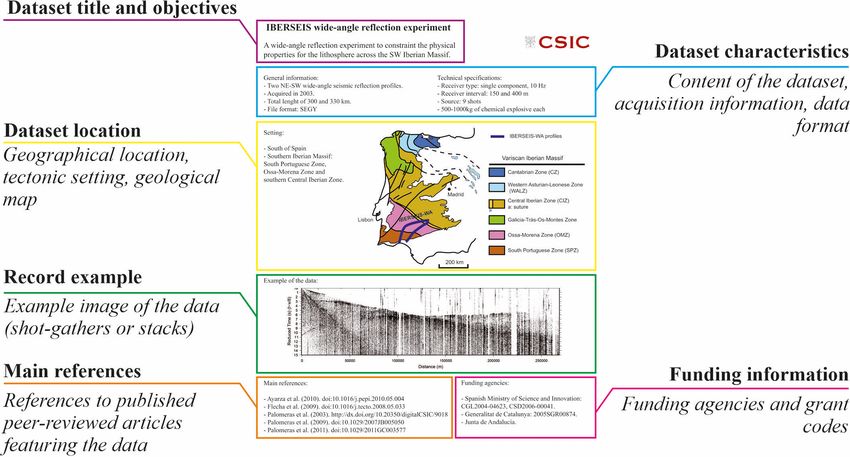
1054                                                                           I. DeFelipe et al.: Reassessing the lithosphere

1   Introduction                                                   //ds.iris.edu/ds/nodes/dmc/, last access: March 2021, USA),
                                                                   and the International Geological Correlation Programme
Controlled-source seismology is a fundamental tool for solid       (IGCP) initiative (http://www.earthscrust.org.au/, last access:
Earth sciences, as it provides very valuable information about     March 2021).
the physical properties and structure of the Earth’s crust            Within the European research community there is a con-
and upper mantle. Controlled-source seismic experiments            sistent vision of fostering global open science as a driver for
have been undertaken in all tectonic settings since the mid-       enabling a new paradigm of transparent, data-driven science
nineteenth century (Mintrop, 1947; Jacob et al., 1999), shed-      and accelerating innovation. This vision is becoming a real-
ding light on our current understanding of the Earth’s inte-       ity thanks to a number of ambitious programmes internation-
rior, from its composition and structure to its evolution. The     ally supported. The European Open Science Cloud (https:
outputs of these experiments, deep seismic sounding (DSS)          //www.eosc-portal.eu/, last access: March 2021) is driving
data, are generally expensive, logistically complex to ac-         towards a virtual environment with open and seamless ser-
quire, and often result from a huge scientific effort involving    vices for storage, management, analysis, and reuse of re-
national and international institutions. Therefore, it is imper-   search data by federating existing scientific data infrastruc-
ative that legacy and new acquired data are easily available       tures, currently dispersed across disciplines and European
for future generations of geoscientists. Taking into account       countries. In the same way, the European Strategy Forum
that data-processing algorithms are constantly evolving, new       on Research Infrastructures (ESFRI) is a strategic instru-
or additional information can be extracted from these data.        ment to develop the scientific integration of Europe and to
   Aware of the value of DSS data, Prodehl and Mooney              strengthen its international outreach. The European Plate Ob-
(2012) provided a comprehensive, worldwide history of              servation System (EPOS, https://www.epos-eu.org/, last ac-
controlled-source seismological studies acquired from 1850         cess: March 2021), established under ESFRI, was initiated in
to 2005, highlighting the enormous efforts made in the last        2002 to tackle a viable solution for solid Earth challenges. It
170 years to increase our knowledge of the subsurface. Since       is aligned with the Berlin Declaration for the Open Access
the 1970s, ambitious seismic reflection projects have been         to Knowledge in the Sciences and Humanities (2003) which
developed worldwide, acquiring unique datasets that targeted       stipulates that research data products need to be integrated
key lithosphere structures. These datasets provided unprece-       and made accessible through open-access schemes. EPOS
dented images of the lithosphere, characterizing crustal dis-      aims to ensure a long-term plan to facilitate the integration
continuities, major faults, geometry of orogenic belts, and        of data and fosters worldwide interoperability of Earth sci-
other lithospheric features that had not been envisioned be-       ence services to a broad community of users for innovation
fore. Some of these major seismic research programmes that         in science, education, and industry.
acquired DSS normal incidence and wide-angle data include             In close collaboration with EPOS, the Spanish National
COCORP (USA); BIRPS (UK); ECORS (France); DEKORP                   Research Council (CSIC) hosts the “DIGITAL.CSIC” repos-
(Germany); ESCI, IAM and ILIHA (Spain); HIRE and FIRE              itory, where all kinds of scientific data are accessible follow-
(Finland); ESRU and URSEIS (Russia); INDEPTH (Hi-                  ing the international mandates of open-access data and the
malayas); LITHOPROBE (Canada); NFP 20 (Switzerland);               FAIR principles of data management: findable, accessible,
and SINOPROBE (China).                                             interoperable, and reusable (Bernal, 2011; Wilkinson et al.,
   In parallel, the hydrocarbon industry also added value us-      2016). As part of CSIC, Geosciences Barcelona (GEO3BCN,
ing legacy seismic reflection data (Nicholls et al., 2015) by      formerly Institute of Earth Sciences Jaume Almera – ICTJA)
applying new processing approaches and techniques. Fur-            has participated in numerous geophysical projects carried out
thermore, reprocessed high-resolution (HR) seismic reflec-         mainly in the Iberian Peninsula and Morocco during its more
tion data have also been used in exploration for mineral re-       than 50 years’ of history. The unique geological characteris-
sources (Manzi et al., 2019; Donoso et al., 2020) and civil        tics of these areas (outstanding record of the Variscan orogen
engineering (Martí et al., 2008) and are also successful for       and Alpine mountain belts, wide foreland basins, good acces-
the characterization of seismogenic zones and hazard assess-       sibility and outcrop conditions, etc.) make them an excellent
ment (Ercoli et al., 2020). Therefore, legacy data are ex-         target to study the structure of the lithosphere and the spa-
tremely valuable for basic and applied Earth sciences, and         tial and temporal evolution of tectonic extension, mountain
their preservation and availability constitute an effort that      building, plate tectonics, and evolution of rifts (Daignières
should contribute to move science forward.                         et al., 1981, 1982; Gallart et al., 1980, 1981; Choukroune
   The international community has focused on the preserva-        and ECORS Team, 1989; Roca et al., 2011; Simancas et
tion of the data, facilitating their access. Examples of these     al., 2013; Martínez Poyatos et al., 2012; Macchiavelli et al.,
efforts include the SIGEOF database (Geological and Mining         2017; Ruiz et al., 2017; Cadenas et al., 2018; DeFelipe et
Institute of Spain) that hosts geophysical data of the Iberian     al., 2018, 2019). These data have provided a full picture of
Peninsula (http://info.igme.es/SIGEOF/, last access: March         the physical structure of the Mohorovičić discontinuity (Car-
2021), OpenFIRE (https://avaa.tdata.fi/web/fire, last access:      bonell et al., 2014b; Díaz et al., 2016), the accommodation of
March 2021, Finland), the IRIS-PASSCAL consortia (https:           shortening mechanisms at different crustal levels (Simancas

Earth Syst. Sci. Data, 13, 1053–1071, 2021                                         https://doi.org/10.5194/essd-13-1053-2021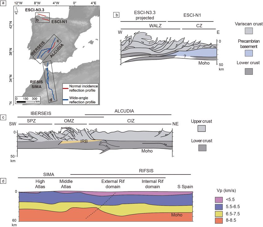
I. DeFelipe et al.: Reassessing the lithosphere                                                                               1055

et al., 2003, 2013), the structure of the Iberian margins and
mountain ranges (Pedreira et al., 2003; Ayarza et al., 2004;
Fernandez-Viejo et al., 2011; Ruiz et al., 2017), and the effect
of Alpine reactivation in the Iberian Peninsula (Teixell et al.,
2018; Andrés et al., 2019). In addition to those continental-
scale projects, an increased interest in the study of the shal-
low subsurface has emerged in the last decade in different
areas of the Iberian Peninsula. These interests are related
to natural resource exploration and exploitation, geo-energy
and permanent storage applications, earthquake hazard as-
sessment, or infrastructure planning (Alcalde et al., 2013a,
b; Martí et al., 2019).
   Here, we report on the readily available database Seis-
DARE (Seismic DAta REpository), which compiles large
geophysical projects developed in the Iberian Peninsula and
Morocco. Part of the data comprised in this database were
already stored in Geo DB (http://geodb.ictja.csic.es/#dades1,
last access: March 2021). However, they lacked a permanent
digital object identifier (DOI), thus representing an interme-
                                                                   Figure 1. (a) Total views and (b) total downloads of all datasets
diate step in making the datasets FAIR. SeisDARE goes be-
                                                                   from SeisDARE (https://digital.csic.es/handle/10261/101879, last
yond Geo DB by hosting a larger number of datasets, provid-
                                                                   access: January 2021).
ing them with a DOI and linking them to scientific literature
by means of the Scholix facilities and the DataCite Event
Data (Hirsch, 2019, https://search.datacite.org/, last access:        SeisDARE contains 21 datasets (last access: March 2021)
March 2021).                                                       of DSS (normal incidence, NI, and wide angle, WA) and HR
   The geoscientific data are the basis for the generation of      data (Table 1). Our database comprises the data files together
meaningful geological knowledge (Pérez-Díaz et al., 2020),         with a comprehensive description of their general character-
and therefore, the idea behind SeisDARE is to treat the data       istics and the acquisition parameters. Furthermore, a list of
as any scientific publication, making them as relevant as the      authors and publications derived from the data are also pro-
publication itself (Carbonell et al., 2020a; DeFelipe et al.,      vided. Additionally, an index card summarizes the informa-
2020). The purpose of this paper is to provide a general           tion for all projects except for those that are embargoed due
overview of the geological setting of the experiments, a brief     to data policy (i.e. usually a reasonable time period for the
description of each dataset, and the link to the open-access       use of the data by the project members or private companies
data. This database is the result of a fruitful national and       involved). Those files comprise the general information of
international inter-institutional collaboration, aiming to en-     the data, a location map of the seismic data, an image of the
hance multidisciplinary research and to promote advanced           data as an example, references, and funding agencies. Fig-
research networks. Thus, we are actively working in keeping        ure 2 shows an example of the index card of the IBERSEIS-
our database updated, gathering more datasets.                     WA project. Ideally, all the content stored in the database is
                                                                   self-explanatory, so that the inexperienced users can handle
2   Outline of SeisDARE                                            the datasets straightforwardly.
                                                                      In general, the philosophy behind SeisDARE is entirely
The GEO3BCN database comprises multidisciplinary re-               transferable to similar seismic datasets from other areas in
search data. SeisDARE forms part of this database and is           the world. The promoters of SeisDARE are actively look-
constantly being updated. Especially in the last years, the        ing for engagement with other international institutions, ei-
efforts put into the dissemination of the data have yielded        ther by offering to host their datasets or to serve as a model
to a significant increase in the number of views and down-         for the establishment of new similar platforms. This inter-
loads (Fig. 1). The number of view counts has been generally       nationalization effort led to the establishment of a collabora-
increasing with punctual peaks of views and with an out-           tion with the Consortium for Continental Reflection Profiling
standing number of views in September 2020. The number             (COCORP), to host the Hardeman County (Texas) dataset.
of downloads has strikingly increased since October 2019,          This kind of collaboration adds great value to the database
reaching the highest value in April 2020, with more than           by expanding the range of geological settings sampled and
2400 downloads. Additional statistics of each item’s views         strengthening the research network between different institu-
and downloads are available and can be consulted directly in       tions worldwide.
the statistics facilities of the repository.

https://doi.org/10.5194/essd-13-1053-2021                                         Earth Syst. Sci. Data, 13, 1053–1071, 2021
1056 I. DeFelipe et al.: Reassessing the lithosphere
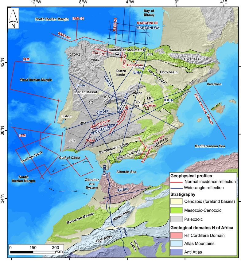
Table 1. Seismic datasets comprised in SeisDARE (DSS: deep seismic sounding; HR: high resolution). The location of the seismic datasets
is shown in Fig. 3. Note that ESCI, MARCONI, IBERSEIS, ALCUDIA, and VICANAS comprise two or three datasets (see text for details).
Dataset Year Seismic data Onshore/offshore Research target Section Dataset reference
ILIHA 1989 DSS wide angle Onshore Iberian Massif 5.1 Díaz et al. (2020)
ESCI-N 1991– DSS normal incidence Onshore and Iberian Massif 5.2 Pérez-Estaún et al.
ESCI 1993 offshore Bay of Biscay (2019)
Valencia Cantabrian Mountains Gallart et al. (1993)
Trough Valencia Trough García-Dueñas et
ESCI Betics Betic Cordillera al. (1991)
IAM 1993 DSS normal incidence Offshore Iberian Atlantic Margin 5.3 Torné et al. (2018)
MARCONI 2003 DSS normal incidence Offshore and Bay of Biscay 5.4 Gallart et al. (2019,
and wide angle onshore 2020)
IBERSEIS 2001 and DSS Onshore Iberian Massif (South 5.5 Pérez-Estaún et al.
2003 normal incidence and Portuguese Zone, Ossa- (2001a, b)
wide angle Morena Zone and Cen- Palomeras et al.
tral Iberian (2003)
Zone)
ALCUDIA 2007 and DSS Onshore Iberian Massif 5.6 Pérez-Estaún et al.
2012 normal incidence and (Ossa-Morena Zone (2007)
wide angle and Central Iberian Pérez-Estaún et al.
Zone) (2012)
SIMA 2010 DSS wide angle Onshore Rif Cordillera and Atlas 5.7 Ayarza et al.
Mountains (2010b)
RIFSIS 2011 DSS wide angle Onshore Rif Cordillera 5.8 Gallart et al. (2011)
CIMDEF 2017 and DSS wide angle Onshore Duero basin, Central 5.9 Ayarza and
2019 Iberian Zone and Tajo Carbonell (2019)
basin
HONTOMÍN 2010 HR normal incidence Onshore CO2 storage site char- 6.1 Alcalde et al.
acterization (2010)
VICANAS 2014 HR normal incidence Onshore Nuclear waste disposal 6.2 Marzán et al. (2013,
site characterization 2015)
INTERGEO 2015 HR normal incidence Onshore Quaternary seismicity 6.3 Martí et al. (2015)
in the Alhama de
Murcia Fault
SOTIEL 2018 HR normal incidence Onshore Mining exploration in 6.4 Alcalde et al.
the Iberian Pyrite Belt (2018)
COCORP 1975 DSS normal incidence Onshore Hardeman County 7 Oliver and Kauf-
Hardeman (Texas, USA) man (1975)
County
3 Geological setting of the Iberian Peninsula and resulting from the NI and WA datasets belonging to Seis-
Morocco DARE, covering an almost complete section of the Iberian
Peninsula (onshore and offshore) and Morocco.
The Variscan orogen resulted from the convergence of the
The Iberian Peninsula and Morocco have experienced a long Laurentia–Baltica and Gondwana continents, yielding to the
and complex geological history since the Paleozoic, resulting supercontinent Pangaea (e.g. Matte, 1991, 2001; Murphy and
in a rich variety of tectonic and sedimentary domains. These Nance, 1991; Simancas et al., 2003; Pérez-Cáceres et al.,
include the Variscan terrains of the Iberian Massif, Pyre- 2016). In the Iberian Peninsula, the main Variscan rock out-
nean Axial Zone and Iberian Chain; broad Mesozoic basins; crop corresponds to the Iberian Massif, and it is divided into
the Alpine mountain belts; and the Cenozoic foreland basins six zones (Julivert et al., 1972; Fig. 3). The West Asturian-
(Fig. 3). In addition, Fig. 4 shows some of the crustal models
Earth Syst. Sci. Data, 13, 1053–1071, 2021 https://doi.org/10.5194/essd-13-1053-2021I. DeFelipe et al.: Reassessing the lithosphere 1057 Figure 2. Example of the index card containing the IBERSEIS-WA project (Sect. 5.5.2) information. Leonese Zone (WALZ) and the Cantabrian Zone (CZ) are perextended crust and exhumed mantle and deep Cretaceous the northernmost zones. The Central Iberian Zone (CIZ) basins in the Pyrenean–Cantabrian realm (e.g. Ziegler, 1988; is the largest zone and includes the entirely allochthonous García-Mondéjar et al., 1996; Jammes et al., 2009; Pedreira Galicia-Trás-Os-Montes Zone (GTOMZ) towards the north- et al., 2015; Tugend et al., 2014, 2015; DeFelipe et al., 2017; west (Martínez Catalán et al., 1997; Arenas et al., 2007). Ruiz et al., 2017). The mechanisms and geodynamic evolu- South of the CIZ, the Ossa-Morena Zone (OMZ) is a highly tion of the Iberian Atlantic margin and Bay of Biscay were deformed area of upper Proterozoic–lower Paleozoic rocks investigated with the pioneer IAM and ESCI-N projects, fol- (Matte, 2001; Pérez-Cáceres et al., 2016, 2017). The south- lowed by the MARCONI initiative (e.g. Banda et al., 1995; ernmost zone of the Iberian Massif is the South Portuguese Álvarez-Marrón et al., 1995a, b, 1996; Pulgar et al., 1995, Zone (SPZ) and hosts the largest concentration of volcanic 1996; Fernández-Viejo et al., 2011; Ruiz et al., 2017). These massive sulfide deposits worldwide, the Iberian Pyrite Belt projects allowed mapping of the offshore distribution of the (Tornos, 2006). The CZ and the SPZ represent the exter- North Pyrenean basins, to assess the lateral variations in the nal zones of the Variscan orogen whereas the rest repre- crust in the North Iberian Margin and to evaluate the inher- sent the internal zones (e.g. Martínez Catalán et al., 1997). itance of the extensional structures in the Alpine orogeny The structure of the CZ, WALZ, CIZ, OMZ, and SPZ has (Álvarez-Marrón et al., 1996; Fernández-Viejo et al., 1998; been studied through the ESCI-N, IBERSEIS, and ALCU- Ferrer et al., 2008; Roca et al., 2011). DIA experiments (Fig. 4b and c). In these areas the Alpine From the Late Cretaceous to the Miocene, the Alpine inversion resulted mostly in localized faults and well-defined convergence resulted in the tectonic inversion of the Meso- crustal imbrications; thus the data reflect a nearly complete zoic basins and mountain building (e.g. Muñoz, 1992; Teix- crustal section of the late Variscan orogen. A main feature ell, 1998; Rosenbaum et al., 2002a; Teixell et al., 2016, observed along the Iberian Massif is the poor coupling ex- 2018; DeFelipe et al., 2018, 2019). Seismic imaging in the isting between the upper and lower crustal reflectivity, which Cantabrian Mountains, the North Iberian Margin and Duero has been interpreted as the image of contrasting deformation basin area allowed the interpretation of a crustal thickening mechanisms to accommodate shortening at both crustal lev- under the Cantabrian Mountains, with the Iberian crust sub- els (Simancas et al., 2003, 2013). ducting towards the north (Pulgar et al., 1996; Gallastegui, Throughout most of the Mesozoic, lithospheric extension 2000; Gallart et al., 1997a; Pedreira et al., 2003, 2015; in relation to the opening of the Atlantic Ocean and Bay Gallastegui et al., 2016). More recently, Teixell et al. (2018) of Biscay gave way to the formation of rift domains of hy- suggested the southwards subduction of the Bay of Biscay https://doi.org/10.5194/essd-13-1053-2021 Earth Syst. Sci. Data, 13, 1053–1071, 2021
1058                                                                             I. DeFelipe et al.: Reassessing the lithosphere

Figure 3. Geological map of the Iberian Peninsula and north of Africa with the seismic profiles provided in SeisDARE. The geological
units are simplified from the IGME Geological Map of the Iberian Peninsula 1 : 1 000 000 (Rodríguez Fernández et al., 2014) and the
bathymetry and topography from OpenTopography (Ryan et al., 2009) and Natural Earth. Note that the MARCONI offshore experiment
acquired simultaneously normal incidence and wide-angle reflection, whereas on land, only wide-angle data were acquired. BCB: Basque-
Cantabrian basin; CZ: Cantabrian Zone; WALZ: West Asturian-Leonese Zone; GTOMZ: Galicia-Trás-Os-Montes Zone; CIZ: Central Iberian
Zone; OMZ: Ossa Morena Zone; SPZ: South Portuguese Zone; ICS: Iberian Central System; LR: Loranca Basin.

crust along the MARCONI-1 profile, although of probable              ments of the Iberian subplate (e.g. Sanz de Galdeano, 1990;
limited extent at this longitude. Towards the west, along            Carbonell et al., 1997; Rosenbaum et al., 2002b; Platt et
the IAM-12 profile, the oceanic crust of the Bay of Bis-             al., 2013). South of the Rif, the Atlas Mountains were also
cay subducts towards the south (Teixell et al., 2018). This          formed as a consequence of the Cenozoic-to-present conver-
subduction is also imaged in the ESCI-N3.2 and ESCI-N3.3             gence between Eurasia and Africa. The Moroccan part of
profiles as 3D inclined subcrustal reflections (Ayarza et al.,       this orogen is formed by two branches, the High and Mid-
2004).                                                               dle Atlas, that correspond to inverted Mesozoic basins (e.g.
   Towards the south of the Iberian Peninsula, the Gibral-           Arboleya et al., 2004). The RIFSIS and SIMA projects inves-
tar Arc System comprises the Betic Cordillera and the Rif,           tigated these areas, sampling the African lithosphere down to
the westernmost belt of the Alpine chains (Fig. 3). It is a          the Moroccan Atlas. The topography of the latter is too high
broad arcuate collision zone separated by the Alborán Sea            when considering the context of limited orogenic shorten-
that resulted from the convergence between the Eurasian              ing featured in this area. Volcanism and intermediate depth
and African plates since the Miocene. This area represents a         seismicity support a model where isostasy is not enough to
complex tectonic scenario with periods of compression over-          maintain the orogenic load; thus dynamic topography must
printed by extensional episodes and dextral strike-slip move-        have played a key role (Ayarza et al., 2005; Teixell et al.,

Earth Syst. Sci. Data, 13, 1053–1071, 2021                                           https://doi.org/10.5194/essd-13-1053-2021
I. DeFelipe et al.: Reassessing the lithosphere                                                                            1059

2005, 2007). The RIFSIS and SIMA experiments shed some            (SEG-Y or SU). The datasets are accessible as raw data,
light on the P-wave velocity structure of the lithosphere and     and processed stack cross sections (migrated or not) are also
the Moho topography in this large area, improving existing        available for some datasets. Raw data will fulfil the needs
models (Ayarza et al., 2014; Gil et al., 2014; Fig. 4d).          of researchers who would like to develop new processing ap-
                                                                  proaches, and the already processed data will provide images
                                                                  for scientists aiming to test alternative interpretations.
4   Technical aspects of the data
                                                                  5     DSS datasets
The datasets available in SeisDARE comprise controlled-
source DSS and HR data. All these datasets feature spe-           This section describes the DSS datasets hosted in SeisDARE,
cific acquisition parameters which are detailed in their cor-     ordered by year of acquisition, that sampled different parts
responding bibliography. This section provides a brief sum-       of the Iberian Peninsula and Morocco. Each subsection pro-
mary of the main acquisition characteristics of the different     vides a description of the individual datasets and the most
datasets.                                                         relevant references associated.
   For instance, four types of sources were used in the acqui-
sition of the on-land data. For DSS data (i) most of the WA
experiments used controlled explosions with charges ranging       5.1     ILIHA
from 500 to 1000 kg; (ii) large quarry blasts were used as en-    The pioneer ILIHA (Iberian LIthosphere Heterogeneity and
ergy sources in the acquisition of the ILIHA project; (iii) for   Anisotropy) project was acquired in 1989 and consisted of
most of the NI experiments vibroseis trucks (4, 22, or 32 t)      a star-shaped arrangement of six long-range wide-angle re-
were used, although ESCI-N1 and ESCI-N2 were acquired             flection profiles covering the entire Iberian Peninsula. It was
using explosions of 20 kg. For HR data, two types of sources      designed to study the lateral heterogeneity and anisotropy of
were used: (i) 250 kg accelerated-weight drop and (ii) 15–        the deep lithosphere of the Variscan basement in the Iberian
32 t vibroseis trucks. Regarding the DSS offshore data, the       Peninsula. The results of this project suggested a layered
energy sources were airgun arrays with 2000 psi (13.85 Mpa)       lower lithosphere reaching at least 90 km depth, contrasting
with different ranges of volumes depending on the research        with the heterogeneity of the Variscan surface geology (Díaz
vessels used in each experiment: MV Seisquest with a vol-         et al., 1993, 1996).
ume of 5490 in.3 (90 L) (in ESCI-N), the MV Geco Sigma
with a volume of 7542 in.3 (123 L) (in IAM), and the BIO
                                                                  5.2     ESCI
Hespérides with volumes ranging from 2690 to 1435 in.3 (44
to 23.5 L) (in MARCONI).                                          The ESCI project (Estudios Sísmicos de la Corteza Ibérica –
   The receivers onshore consisted of geophones of one or         Seismic Studies of the Iberian Crust) was conducted to obtain
three components with sensors from 10 Hz to 20 s. A num-          multichannel deep seismic reflection images in three areas of
ber of wide-angle experiments (IBERSEIS-WA, ALCUDIA-              the Iberian Peninsula (Fig. 3): the NW of the Iberian Penin-
WA, SIMA, RIFSIS, and CIMDEF) used a relatively large             sula (ESCI-N), the Gulf of Valencia (ESCI Valencia Trough),
number of receivers, equipped with RefTek 125A instru-            and the Betic Cordillera (ESCI Betics).
ments (also known as TEXANS) that belong to the IRIS-
PASSCAL instrument pool. In addition, the CIMDEF ex-
                                                                  5.2.1    ESCI-N
periment also used SERCEL-Unite data loggers equipped
with 10 Hz geophones and WorldSensing SPIDER data log-            ESCI-N comprises four multichannel seismic experiments,
gers with 2 Hz sensors. For the MARCONI-WA experiment,            some of them also including wide-angle reflection datasets.
RefTek 72A and Leas-Hathor data loggers with sensors of           ESCI-N1 is an onshore profile that runs E–W through the
1, 5, and 20 s were used. The offshore receivers used in          Variscan structure of the WALZ and the CZ. ESCI-N2, also
the NI experiments were hydrophone streamers with differ-         onshore, runs with a N–S orientation and was aimed to im-
ent lengths. Finally, the WA experiments used ocean-bottom        age the Alpine imprint of the Cantabrian Mountains. ESCI-
seismometers or hydrophones (OBSs or OBHs) as recording           N3 is made up of three seismic profiles that follow a swerved
devices.                                                          line in a mainly E–W direction in Galicia and west Asturian
   The data included in SeisDARE are in SEG-Y, SEG-D              offshore. Finally, ESCI-N4 runs in a N–S direction offshore
(https://seg.org/Publications/SEG-Technical-Standards, last       (Álvarez-Marrón et al., 1995a, b, 1996, 1997; Gutiérrez-
access: March 2021; Barry et al., 1975), or XDR SU format         Alonso, 1997).
(https://wiki.seismic-unix.org/doku.php, last access: March          Beneath the CZ, ESCI-N1 shows the presence of a basal
2021; Forel et al., 2008), the most commonly used formats         gently west-dipping detachment identified as the Cantabrian
for seismic data. The older datasets (ILIHA, ESCI, and IAM)       Zone basal detachment. Towards the WALZ, a stack of thrust
were recorded on magnetic track tapes and were success-           sheets probably affecting Precambrian rocks is placed above
fully recovered and transformed to readable digital formats       a crustal-scale ramp dipping to the west (Pérez-Estaún et al.,

https://doi.org/10.5194/essd-13-1053-2021                                         Earth Syst. Sci. Data, 13, 1053–1071, 2021
1060 I. DeFelipe et al.: Reassessing the lithosphere
Figure 4. (a) Map of the Iberian Peninsula and north of Africa with the location of the ESCI-N, IBERSEIS, ALCUDIA, RIFSIS, and SIMA
projects. The topography is from OpenTopography (Ryan et al., 2009); (c) crustal structure of the southern Iberian Massif (SPZ: South
Portuguese Zone; OMZ: Ossa Morena Zone; and CIZ: Central Iberian Zone; IRB: Iberian Reflective Body) revealed by the IBERSEIS and
ALCUDIA projects (after Simancas et al., 2013; Ehsan et al., 2015; Palomeras et al., 2009); (b) crustal structure of the northern Iberian
Massif revealed by the ESCI-N1 and N3.3 profiles (WALZ: West Asturian-Leonese Zone; CZ: Cantabrian Zone) (after Ayarza et al., 1998;
Pérez-Estaún et al., 1997; Simancas et al., 2013); and (d) P-wave velocity model obtained from the wide-angle reflection data of RIFSIS and
SIMA (simplified from Ayarza et al., 2014; Gil et al., 2014).
1994, 1997; Gallastegui et al., 1997; Fernández-Viejo and and the Pyrenees to the north (Fig. 3). Different geodynamic
Gallastegui, 2005). The ESCI-N3 depicted a Moho offset be- models were proposed for the Valencia Trough during the
tween the CIZ and the WALZ, and the southward subduction 1980s and early 1990s, but there was a lack of agreement
of the oceanic crust of the Bay of Biscay as a consequence on its crustal structure and geodynamic evolution. Therefore,
of Alpine shortening (Martínez Catalán et al., 1995; Álvarez- ESCI Valencia Trough was conducted to shed light on the
Marrón et al., 1995a, b, 1996; Ayarza et al., 1998, 2004). Fur- structure of the western Mediterranean, providing a contin-
thermore, ESCI-N2 and ESCI-N4 revealed a crustal thicken- uous image of this area for the first time. This experiment
ing beneath the highest summits of the Cantabrian Moun- revealed that beneath the Valencia Trough the crust has con-
tains which was interpreted as the northward subduction of tinental affinity and is strongly attenuated. The Moho is lo-
the Iberian crust under this mountain range (Pulgar et al., cated at 17–18 km depth, thus being the strongest thinning
1995, 1996; Fernández-Viejo and Gallastegui, 2005). reported so far in comparable passive margins (Gallart et al.,
1994, 1997b).
5.2.2 ESCI Valencia Trough
5.2.3 ESCI Betics
The Valencia Trough is a NE–SW-trending Cenozoic basin
in the western Mediterranean Sea bounded by the Betic The ESCI Betics dataset consists of two profiles in the south-
Cordillera to the southwest, the Iberian Chain to the west east of Spain through the Betic Cordillera (Fig. 3). The ESCI
Earth Syst. Sci. Data, 13, 1053–1071, 2021 https://doi.org/10.5194/essd-13-1053-2021I. DeFelipe et al.: Reassessing the lithosphere 1061
Betics 1 is a 90 km long NW–SE profile that crosses the et al., 2010). On the other hand, the basement of the Gulf
Guadalquivir basin, the external part of the Betic Cordillera, of Cádiz is a continental crust that thins progressively from
and the Neogene–Quaternary basin at the limit with the in- east to west (González-Fernández et al., 2001). The transi-
ternal zone. The ESCI Betics 2 profile runs for 160 km across tion from the continental crust of the Gulf of Cádiz to the
the emerged part of the Alborán domain with a NNE–SSW transitional/oceanic crust of the Gorringe Bank is imaged as
orientation (Carbonell et al., 1997; Vegas et al., 1997). The a series of E–W-oriented thrusts, folds, and diapirs formed
main aim of this project was to image the structure of the during the Cenozoic convergence (Tortella et al., 1997).
crust, as well as to investigate the development of collisional
structures, the response to extensional stresses in regions 5.4 MARCONI
of recently thinned crust, and the correlation between the
crustal structure and the distribution of seismicity in a tec- The deep seismic survey MARCONI (MARgen COntinen-
tonically active area (García-Dueñas et al., 1994). It provided tal Nord Iberico – North-Iberian Continental Margin) was
the first complete structural transect of the northern flank of carried out to understand the processes that governed the
the Gibraltar Arc and the Alpine metamorphic complexes of evolution of the Bay of Biscay and to establish the litho-
the Betic Cordillera. spheric structure of its southeastern part (Gallart et al., 2004).
It included the simultaneous acquisition of 11 multichannel
5.3 IAM
and wide-angle deep seismic reflection profiles with a to-
tal length of 2000 km (Fernández-Viejo et al., 2011; Fig. 3).
The IAM (Iberian Atlantic Margin) project comprised 19 off- This project imaged the sedimentary architecture in this part
shore reflection seismic profiles covering a total length of of the Bay of Biscay where no boreholes or direct geologi-
∼ 3800 km. This project was set to study the deep continen- cal data were available. The results of the MARCONI project
tal and oceanic crusts in different parts of the Iberian Atlantic confirmed the existence of compressive N-directed structures
margin, thus sampling the north, west, and south Iberian mar- related to the Alpine orogeny and developed at the foot of
gins (Banda et al., 1995; Torné et al., 1995, 2018; Fig. 3). the continental slope, as well as the existence of NNE–SSW-
The North Iberian Margin was imaged by a N–S profile oriented transfer zones. Furthermore, it helped to identify the
in the western part of the Bay of Biscay (Fernández-Viejo et Cretaceous rift domains. The analysis of the velocity–depth
al., 1998). It revealed the crustal structure in this area and its profiles and the multichannel seismic data allowed the con-
nature for the first time. Results indicate that the sedimentary clusion that the SE part of the Bay of Biscay is formed by
infill of the abyssal plain is probably underlain by an oceanic a stretched/thinned continental crust with the Moho located
basement (Álvarez-Marrón et al., 1997). The Moho is imaged between 30 and 20 km, the NW part of the study area is in-
as a subhorizontal reflection package located on land at 23– terpreted as a transitional crust from continental to oceanic
26 km (Córdoba et al., 1987) that features a rapid shallowing with the Moho identified at less than 20 km, and the on-land
up to 15 km depth in the abyssal plain. part of the experiment (imaged only with the wide-angle ex-
The West Iberian Margin is structurally divided in four periment) showed the continental crust thickening as a conse-
zones: oceanic crust, peridotite ridge, transition zone, and quence of the Alpine orogeny (Ferrer et al., 2008; Fernández-
thinned continental crust. The crust decreases its thickness Viejo et al., 2011; Roca et al., 2011; Ruiz, 2007; Ruiz et al.,
progressively to the west towards an oceanic crust of 6.5– 2017).
7 km thick (Pickup et al., 1996; Sutra and Manatschal, 2012;
Sutra et al., 2013). The peridotite ridge is a basement high 5.5 IBERSEIS
that coincides with the eastward boundary of the seafloor-
spreading magnetic anomalies (Dean et al., 2000). The tran- In SW Spain, a NI profile and two WA seismic profiles were
sition zone has been interpreted as a tectonically exposed up- acquired in 2001 and 2003 respectively to image the south-
per mantle, extensively serpentinized, that continues laterally ernmost part of the Iberian Massif in the framework of the
to the continental crust. IBERSEIS project (Fig. 3).
The Southern Iberian Margin has undergone a complex
tectonic history through a sequence of Mesozoic rifting and 5.5.1 IBERSEIS-NI
collisional events associated with the Africa–Eurasia plate
convergence (González et al., 1996). This area corresponds IBERSEIS-NI is a 303 km long NE–SW-oriented seismic re-
to the Azores–Gibraltar seismic zone and comprises two re- flection profile that sampled three major tectonic domains:
gions: the Gorringe Bank and the Gulf of Cádiz. The Gor- the SPZ, the OMZ, and the southernmost part of the CIZ
ringe Bank is characterized by an irregular topography and (Figs. 3 and 4c; Simancas et al., 2003, 2006). The high-
a large-amplitude gravity anomaly (Souriau, 1984; Gràcia resolution image obtained matched existing geological cross
et al., 2003; Cunha et al., 2010). It consists of mafic and sections and indicated the presence of left-lateral strike-slip
ultramafic plutonic and extrusive rocks covered by Aptian displacements of Carboniferous age in the boundaries of the
to Pliocene sediments (Tortella et al., 1997; Jiménez-Munt OMZ. The profile also provides an image of the alleged
https://doi.org/10.5194/essd-13-1053-2021 Earth Syst. Sci. Data, 13, 1053–1071, 20211062 I. DeFelipe et al.: Reassessing the lithosphere
suture between the OMZ and the SPZ, which is formed lower crust tectonic wedge in the southern segment of the
by a complex accretionary prism of sediments and oceanic transect, causing a local crustal thickening. The interpreted
basalts. The limit between the OMZ and the CIZ is assem- structures, as deduced from surface geology and the seis-
bled as an accretionary wedge of high-pressure metamorphic mic image, show that deformation was distributed homoge-
rocks. Fold-and-thrust belts in the upper crust merge down- neously in the upper crust, whereas it was concentrated in
wards in a decoupling horizon between the upper and the wedge and thrust structures at specific sectors in the lower
lower crust. In the OMZ and CIZ, a 175 km long thick band crust (Martínez Poyatos et al., 2012; Simancas et al., 2013).
of relatively high amplitude, the Iberian Reflective Body
(IRB), is interpreted as a layered mafic–ultramafic body in- 5.6.2 ALCUDIA-WA
truded along a mid-crustal decollement. In the entire tran-
sect, a horizontal Moho reflection at 10.5 s suggests a 30– The ALCUDIA-WA experiment aimed to constrain the litho-
33 km thick crust (Simancas et al., 2003; Carbonell et al., spheric structure and resolve the physical properties of the
2004; Simancas et al., 2006). crust and upper mantle in the CIZ. This profile has led to
a well-constrained 280 km long and 50 km deep P-wave ve-
5.5.2 IBERSEIS-WA
locity model. Its major contribution was to confirm the ex-
istence of an incipient crustal thickening towards the Tajo
The IBERSEIS-WA profile was acquired with the aim of basin. High velocities towards the northern part of the profile
providing constraints on the physical properties of the litho- correspond to igneous and/or high-grade metamorphic rocks
sphere beyond the results obtained in the IBERSEIS-NI pro- in agreement with the geology of the Iberian Massif, in the
file. The IBERSEIS-WA project consisted of two transects area close to the south of the Iberian Central System (Ehsan
running subparallel in a NE–SW to ENE–WSW direction. et al., 2015). In addition, a new interpretation of these data
Transect A coincides with the trace of the IBERSEIS-NI provides a S-wave model and Poisson’s ratio values which
profile, and transect B was located farther to the east. Both allowed for a more accurate model of the nature of the crust
transects join at their northern end. The main results of this (Palomeras et al., 2021).
project provided the P- and S-wave velocity models of the
crust and upper mantle in this region for the first time. These 5.7 SIMA
experiments also allowed modelling of the density (Palom-
eras et al., 2011a) and the Poisson’s ratio (Palomeras et al., SIMA (Seismic Imaging of the Moroccan Atlas) is a wide-
2011b), which helped to provide an additional petrological angle reflection seismic experiment that runs through the Rif,
description to estimate the crustal composition. Furthermore, Middle and High Atlas, and Sahara craton of Morocco. This
it allowed the location of the crust–mantle boundary at a project provided the P-wave velocity structure of the crust
depth of 31–33 km and identification of a subcrustal discon- and the geometry of the Moho boundary. Final models im-
tinuity at 66–70 km (Palomeras et al., 2009), later interpreted age the Atlas limited crustal root, which is defined by the
as the Hales discontinuity or gradient zone (Ayarza et al., northward imbrication of the Sahara crust underneath the At-
2010a). las itself. The limited extension of the crustal root supports
the need of dynamic topography models to explain the cur-
5.6 ALCUDIA
rent Atlas topography (Ayarza et al., 2014). In addition, the
low P-wave velocities obtained in the lower crust and mantle
The ALCUDIA dataset consists of two experiments, NI and of the Middle and High Atlas were assigned to the existence
WA, acquired in 2007 and 2012, respectively. These two ex- of high temperatures and partial melts at these levels, prob-
periments sampled the CIZ from the boundary with the OMZ ably as a consequence of the Cenozoic-to-present magmatic
to the northern part of the Tajo basin in approximately a NE– activity of the Atlas region due to mantle upwelling. These
SW direction. It constitutes the northward prolongation of low P-wave velocities might indicate slightly lower densities
the previously acquired IBERSEIS seismic profiles (Figs. 3 that could modify the existing gravity models (Ayarza et al.,
and 4c). 2005).
5.6.1 ALCUDIA-NI 5.8 RIFSIS
ALCUDIA-NI is a 230 km long NE–SW profile that im- The RIFSIS wide-angle reflection seismic experiment con-
aged the lithospheric architecture of the Variscan orogen sists of two E–W- and N–S-oriented profiles, 330 and 430 km
in the CIZ (Martínez Poyatos et al., 2012). The processed long respectively. This acquisition geometry was designed to
ALCUDIA-NI seismic profile shows a Moho discontinuity target the significantly low Bouguer anomaly associated with
at ∼ 10 s TWT (two-way time, ca. 30 km depth) that over- this mountain range (Hildengrand et al., 1988). This project,
lies a mantle where subhorizontal reflectivity was identified which also aimed to improve the geodynamic models of the
between 14 and 19 s TWT. The most prominent feature is a Gibraltar Arc, identified a 50 km deep crustal root below the
Earth Syst. Sci. Data, 13, 1053–1071, 2021 https://doi.org/10.5194/essd-13-1053-2021I. DeFelipe et al.: Reassessing the lithosphere 1063
Rif that thins rapidly towards the east to 20 km in the con- 6.2 VICANAS
tact between the external part of the Rif with the former
The increased need of facilities for temporal and long-term
North African margin (Gil et al., 2014). Jointly, RIFSIS and
storage of radioactive waste has encouraged new geologi-
SIMA provided a 700 km long profile from the southernmost
cal and geophysical projects to characterize the structure of
Iberian Peninsula to the northern Sahara desert (Carbonell et
suitable settings. Within the framework of the VICANAS
al., 2013, 2014a).
project, four reflection seismic profiles and a 3D HR seis-
mic tomography dataset were acquired in the Loranca Basin
5.9 CIMDEF (Fig. 3). The 2D seismic reflection profiles were intended to
The most recent wide-angle reflection–refraction experiment characterize the shallow subsurface (up to 1000 m) at the re-
in the Iberian Peninsula was acquired as part of the CIMDEF gional level, focusing on faults and fracture networks that
project (Andrés et al., 2019; Carbonell et al., 2020b). This could potentially affect the stability of the waste disposal
project aimed to obtain a P-wave velocity model of the west- site. The HR seismic tomography survey provided a full 3D
ern part of the Duero basin, the CIZ, including that of the P-wave seismic velocity image of an area of 500 m × 500 m
Iberian Central System and the Tajo basin. This profile was (Marzán et al., 2016, 2019). This experiment was specially
meant to fill the data gap between the ALCUDIA and IBER- designed to image the upper 100 m that directly interacts with
SEIS profiles in the south and the ESCI-N profiles in the the ongoing construction works. The seismic tomography re-
north (Fig. 3). The dataset was acquired along two time pe- sults combined with geophysical measurements from bore-
riods: the seismic survey carried out in 2017 consisted of holes and 2D electrical resistivity tomography profiles pro-
two profiles, NNW–SSE- and E–W-oriented of ca. 275 and vided a detailed mapping of the different lithology contacts
135 km length respectively. The survey carried out in 2019 that build up the sedimentary sequence filled up to 200 m
consists of a NW–SE 340 km long profile. This dataset is em- of fluvial and lacustrine facies sediments (Álvarez-Marrón
bargoed until 1 January 2024. et al., 2014; Martí et al., 2019; Marzán et al., 2019). Within
the scope of this project, Marzán et al. (2021) reinterpreted
the 3D HR seismic dataset to provide a more consistent 3D
6 HR seismic dataset
P-wave velocity model by integrating the resistivity model
In the 2010s, HR reflection seismic experiments were fo- with well-log data. To jointly interpret these data, the authors
cused on shallow subsurface targets. These experiments were developed a machine-learning scheme that resulted in a 3D
acquired with different objectives, including reservoir char- lithological model highly well correlated with the known ge-
acterization for carbon capture and storage (CCS), nuclear ology.
waste storage, mineral resource exploration, and seismic haz-
ard assessments. These experiments involved imaging with 6.3 INTERGEO
both controlled and natural seismic sources and provided im- The INTERGEO dataset aims to characterize the seismo-
ages and velocity models of the subsurface, from approxi- genic behaviour of active faults in strike-slip tectonic con-
mately 50 to 2000 m depth. texts. The case study of this project is the Alhama de Murcia
Fault (AMF), located in the Betic Cordillera (Fig. 3). This
6.1 HONTOMÍN fault was responsible for one of the most destructive recent
To characterize the first Spanish research facility for geolog- earthquakes in Spain (9 fatalities, 300 injuries, and serious
ical storage of CO2 , a 3D reflection seismic experiment was damages), occurring in May 2011 in Lorca, with a moment
carried out in Hontomín (Fig. 3). This area is located in the magnitude, Mw , of 5.2 (Martínez-Díaz et al., 2012). This
southwestern part of the Basque–Cantabrian basin (Fig. 3), earthquake was triggered by a rupture area of 3 km × 4 km
which developed as a thick Mesozoic basin, tectonically in- along the AMF in a transpressive context. Thus, in order to
verted during the Alpine orogeny (e.g. DeFelipe et al., 2018, image the complex structure at depth of the southwestern
2019). This experiment targeted a saline aquifer located at part of the AMF, six NW–SE-oriented reflection seismic pro-
1450 m depth within Lower Jurassic carbonates with a main files were successfully acquired. The seismic reflection pro-
seal formed by interlayered Lower to Middle Jurassic marl files and travel time tomography allowed the identification
and limestone. The 3D geological structure consists of an and characterization of the contact between the Miocene–
asymmetric dome crosscut by a relatively complex fault sys- Pliocene detrital sediments and the basement, the internal
tem (Alcalde et al., 2013a, b, 2014). This study set the basis structure of the AMF, and its different branches (Gascón
for the first CSS pilot plant in Spain. The dataset is embar- Padrón, 2016; Ardanaz et al., 2018).
goed until 31 December 2024.
https://doi.org/10.5194/essd-13-1053-2021 Earth Syst. Sci. Data, 13, 1053–1071, 20211064 I. DeFelipe et al.: Reassessing the lithosphere
6.4 SOTIEL 9 Conclusions and final considerations
The European Institute of Technology through the RawMa- Seismic reflection data (normal incidence and wide angle)
terials programme has encouraged the development of cost- provide a high-resolution image of the lithosphere and set
effective, sustainable, and safe research and innovation so- constraints on the structure and nature of the deep and shal-
lutions for mineral exploration. Within this framework, the low subsurface. The controlled-source seismic data are use-
SIT4ME project has implemented seismic mineral explo- ful not only in basic science but also in applied science, like
ration methods at a reduced cost, analysing the efficiency in resource exploration and natural hazard assessment. Deep
and capabilities of controlled-source (e.g. reflection imaging seismic sounding data data are expensive and logistically
techniques) and natural-source (e.g. ambient noise interfer- complex to acquire and often require a huge scientific effort
ometry) methods in mining areas. For this purpose, a multi- involving several national and international research groups.
method seismic dataset was acquired in the Sotiel-Coronada The reproducibility of scientific results is dependent on the
mine in the Iberian Pyrite Belt (SPZ) to image a massive sul- availability of data, which reinforces the paradigm of trans-
fide ore body intruded in volcanic and siliciclastic rocks at parent and open-access data-driven science as well as fosters
a depth of 300–500 m (Alcalde et al., 2019). This dataset is innovation. Legacy data can be useful by themselves or by
embargoed until 1 April 2022. applying the latest innovative processing techniques to gener-
ate new meaningful outputs. SeisDARE has been developed
7 Enlarging borders in DSS data sharing: COCORP to facilitate the preservation and reuse of the existing data by
Hardeman County, Texas future generations of geoscientists by hosting seismic data in
the online institutional repository DIGITAL.CSIC. The Seis-
The Consortium of Continental Reflection Profiling DARE database accomplishes the international mandates of
(COCORP, http://www.geo.cornell.edu/geology/cocorp/ open-access data and the FAIR principles of data manage-
COCORP.html, last access: March 2021) was a research ment. It is the result of a close collaboration between national
group that pioneered seismic reflection profiling of the crust and international institutions and encourages new networks
and upper mantle. COCORP worked during the 1970s and to make seismic data easily available. Currently, SeisDARE
1980s in the acquisition of more than 8000 km of seismic contains 21 seismic datasets of deep seismic sounding and
profiling in the USA (Brown et al., 1987) and stimulated high-resolution data acquired since the 1980s in the Iberian
major deep seismic exploration programmes in over 20 Peninsula and Morocco. In addition, as a result of this in-
countries, such as ECORS in France, DEKORP in Germany ternationalization effort we established a collaboration with
or LITHOPROBE in Canada. COCORP demonstrated how the scientists that led the Consortium for Continental Reflec-
seismic reflection information on the geological basement tion Profiling (COCORP) to host the pioneering Hardeman
can contribute to address questions in resource exploration County dataset. All these datasets aimed to characterize dif-
(Brown, 1990). In its first experiment COCORP acquired ferent geological settings, ranging from the continental-scale
37 km of common-midpoint (CMP) stacked seismic re- Variscan and Alpine orogens and the offshore Iberian Mar-
flection profiles in Hardeman County, Texas (Oliver et al., gins to exploration-scale studies. SeisDARE is being con-
1976; Schilt et al., 1981). These data imaged the Cambrian stantly updated and is accessible via a web browser. It is free
to Permian sedimentary rocks lying unconformably over a and open, bringing endless research and teaching opportuni-
Precambrian basement intruded by relatively homogeneous ties to the scientific, industrial, and educational communities.
igneous plutons (Oliver et al., 1976). Prominent layering
in the crystalline basement was first imaged in Hardeman
County and was later found to underlie much of the east Author contributions. IDF, JA, MI, DM, MR, IM, JD, PA, IP,
central USA, perhaps representing major igneous intrusions JLFT, RR, and RC worked on the data acquisition, compilation,
on a continental scale (Kim and Brown, 2019). Furthermore, collation, and dissemination of the datasets. CM and IB provided
COCORP Hardeman County proved the viability of using the facilities to upload the datasets into DIGITAL.CSIC. LB pro-
the vibroseis technique to characterize the geological struc- vided additional data to enlarge our database. IDF prepared the
ture of the deep crust, resulting in a widespread technology manuscript with contributions from all co-authors.
of acquisition today (Finlayson, 1975).
Competing interests. The authors declare that they have no con-
8 Data availability flict of interest.
The SeisDARE is available in the Spanish National Re-
search Council repository, DIGITAL.CSIC (https://digital.
csic.es/handle/10261/101879, DIGITAL.CSIC, 2021). A de-
tailed list of the datasets can be found in Table 1.
Earth Syst. Sci. Data, 13, 1053–1071, 2021 https://doi.org/10.5194/essd-13-1053-2021I. DeFelipe et al.: Reassessing the lithosphere 1065
Acknowledgements. We acknowledge support of the publication Álvarez-Marrón, J., Pulgar, J. A., Dañobeitia, J. J., Pérez-Estaún,
fee by the CSIC Open Access Publication Support Initiative through A., Gallastegui, J., Martínez Catalán, J. R., Banda, E., Comas,
its Unit of Information Resources for Research (URICI). We thank M. C., and Córdoba, D.: Results from the ESCIN-4 marine deep
Florian Haslinger and the anonymous reviewer for their constructive seismic profile in the Northern Iberian Margin. Rev. Soc. Geol.
comments that greatly improved the manuscript. Espana, 8, 355–363, 1995b.
Álvarez-Marrón, J., Pérez-Estaún, A., Dañobeitia, J. J., Pulgar, J.
A., Martínez Catalán, J. R., Marcos, A., Bastida, F., Ayarza Ar-
Financial support. This research has been supported by the Eu- ribas, P., Aller, J., Gallart, J., González-Lodeiro, F., Banda, E.,
ropean Plate Observation System (grant nos. EPOS IP 676564 Comas, M. C., and Córdoba, D.: Seismic structure of the northern
and EPOS SP 871121), EIT Raw Materials (grant no. 17024 continental margin of Spain from ESCIN Deep seismic profiles,
SIT4ME), the Seismology and Earthquake Engineering Research Tectonophysics, 264, 153–174, https://doi.org/10.1016/S0040-
Infrastructure Alliance for Europe (grant no. SERA 730900), and 1951(96)00124-2, 1996.
the Ministerio de Ciencia e Innovación (Juan de la Cierva fellow- Álvarez-Marrón, J., Rubio, E., and Torné, M.: Subduction-related
ship – IJC2018-036074-I). structures in the North Iberian Margin, J. Geophys. Res., 102,
22497–22511, https://doi.org/10.1029/97JB01425, 1997.
Álvarez-Marrón, J., Pérez-Estaún, A., Carbonell, R., Marzán,
Review statement. This paper was edited by Kirsten Elger and I., Martí, D., Brown, D., and Pineda, A.: Intraplate strike-
reviewed by Florian Haslinger and one anonymous referee. slip tectonics accommodating late Cenozoic shortening in the
southern Iberian Range (Loranca Basin, Spain), 16th Edi-
tion of the Deep SEISMIX International Symposium on
Multi-Scale Seismic Imaging of the Earth’s crust and Up-
per Mantle, Castelldefels, Barcelona, 12–17 October 2014,
References https://doi.org/10.13140/2.1.3779.6168, 2014.
Andrés, J., Draganov, D., Schimmel, M., Ayarza, P., Palom-
Alcalde, J., Martí, D., Pérez-Estaún, A., and Car- eras, I., Ruiz, M., and Carbonell, R.: Lithospheric image
bonell, R.: 3D reflection seismic imaging of the Hon- of the Central Iberian Zone (Iberian Massif) using global-
tomín CO2 storage site [Dataset], DIGITAL.CSIC, phase seismic interferometry, Solid Earth, 10, 1937–1950,
https://doi.org/10.20350/digitalCSIC/9906, 2010. https://doi.org/10.5194/se-10-1937-2019, 2019.
Alcalde, J., Martí, D., Calahorrano, A., Marzán, I., Ayarza, P., Car- Arboleya, M. L., Teixell, A., Charroud, M., and Julivert,
bonell, R., Juhlin, C., and Pérez-Estaún, A.: Active seismic char- M.: A structural transect through the High and Mid-
acterization experiments of the Hontomín research facility for dle Atlas of Morocco, J. Afr. Earth Sci., 39, 319–327,
geological storage of CO2 , Spain, Int. J. Greenh. Gas Con, 19, https://doi.org/10.1016/j.jafrearsci.2004.07.036, 2004.
785–795, https://doi.org/10.1016/j.ijggc.2013.01.039, 2013a. Ardanaz, O., Dávila, L., Teixidó, T., Martí, D., Martí, A., Quer-
Alcalde, J., Martí, D., Juhlin, C., Malehmir, A., Sopher, D., Saura, alt, P., Rodríguez Escudero, E., Camacho, J., Martínez-Díaz, J.
E., Marzán, I., Ayarza, P., Calahorrano, A., Pérez-Estaún, A., and J., and Carbonell, R.: Caracterización geofísica de la falla de
Carbonell, R.: 3-D reflection seismic imaging of the Hontomín Alhama de Murcia en el sector de la Torrecilla. Iberfault, Ali-
structure in the Basque–Cantabrian Basin (Spain), Solid Earth, cante, 07/2018. Resúmenes de la III Reunión Ibérica sobre Fallas
4, 481–496, https://doi.org/10.5194/se-4-481-2013, 2013b. Activas y Paleosismología, 11–13 June 2018, Alicante (Spain),
Alcalde, J., Marzán, I., Saura, E., Martí, D., Ayarza, P., Juhlin, C., in: Una aproximación multidisciplinar al estudio de las fallas
Pérez-Estaún, A, and Carbonell, R.: 3D geological characteriza- activas, los terremotos y el riesgo sísmico, edited by: Canora
tion of the Hontomín CO2 storage site, Spain: Multidisciplinary Catalán, C., Martín González, F., Masana, E., Pérez-López, R.,
approach from seismic, well-log and regional data, Tectono- and Ortuño, M., 2018 (in Spanish).
physics, 627, 6–25, https://doi.org/10.1016/j.tecto.2014.04.025, Arenas, R., Martínez Catalán, J. R., Martínez Sánchez, S., Fernán-
2014. dez Suárez, J., Andonaegui, P., and Pearce, J. A.: The Vila de
Alcalde, J., Martínez, Y., Martí, D.; Ayarza, P., Ruiz, M., Marzán, I., Cruces ophiolite: A remnant of the early Rheic Ocean in the
Tornos, F., Malehmir, A., Gil, A., Buske, S., Orlowsky, D., and Variscan suture of Galicia (northwest Iberian Massif), J. Geol.,
Carbonell, R.: SIT4ME: Innovative seismic imaging techniques 115, 129–148, https://doi.org/10.1086/510645, 2007.
for mining exploration – Sotiel-Elvira (Spain) dataset, DIGI- Ayarza, P., Martínez Catalán, J. R., Gallart, J., Pulgar, J. A.,
TAL.CSIC, https://doi.org/10.20350/digitalCSIC/8633, 2018. and Dañobeitia, J. J.: Estudio sísmico de la Corteza Ibérica
Alcalde, J., Martínez, Y., Martí, D.; Ayarza, P., Ruiz, M., Marzán, I., Norte 3.3: a seismic image of the Variscan crust in the hin-
Tornos, F., Malehmir, A., Gil, A., Buske, S., Orlowsky, D., and terland of the NW Iberian Massif, Tectonics, 17, 171–186,
Carbonell, R.: SIT4ME: seismic imaging for mining exploration https://doi.org/10.1029/97TC03411, 1998.
in Sotiel-Elvira (Spain), EGU General Assembly 2019, Vienna, Ayarza, P., Martínez Catalán, J. R., Álvarez-Marrón, J.,
Austria, 7–12 April 2019, EGU2019-15568, 2019. Zeyen, H., and Juhlin, C.: Geophysical constraints on the
Álvarez-Marrón, J., Pérez-Estaún, A., Dañobeitia, J. J., Pulgar, J. deep structure of a limited ocean-continental subduction
A., Martínez Catalán, J. R., Marcos, A., Bastida, F., Aller, J., zone at the North Iberian Margin, Tectonics, 23, TC1010,
Ayarza Arribas, P., Gallart, J., González-Lodeiro, F., Banda, E., https://doi.org/10.1029/2002TC001487, 2004.
Comas, M. C., and Córdoba, D.: Results from the ESCI-N3.1 Ayarza, P., Alvarez-Lobato, F., Teixell, A., Arboleya, M. L.,
and ESCI-N3.2 marine deep seismic profiles in the northwestern Teson, E., Julivert, M., and Charroud, M.: Crustal struc-
Galicia Margin, Rev. Soc. Geol. Espana, 8, 331–339, 1995a.
https://doi.org/10.5194/essd-13-1053-2021 Earth Syst. Sci. Data, 13, 1053–1071, 2021You can also read