Repeated ice streaming on the northwest Greenland continental shelf since the onset of the Middle Pleistocene Transition - The Cryosphere
←
→
Page content transcription
If your browser does not render page correctly, please read the page content below
The Cryosphere, 14, 2303–2312, 2020
https://doi.org/10.5194/tc-14-2303-2020
© Author(s) 2020. This work is distributed under
the Creative Commons Attribution 4.0 License.

Repeated ice streaming on the northwest Greenland continental
shelf since the onset of the Middle Pleistocene Transition
Andrew M. W. Newton1,2 , Mads Huuse1 , Paul C. Knutz3 , and David R. Cox1
1 Department of Earth and Environmental Sciences, University of Manchester, Oxford Road, Manchester, M13 9PL, UK
2 Schoolof Natural and Built Environment, Queen’s University Belfast, University Road, Belfast, BT7 1NN, UK
3 Department of Geophysics, Geological Survey of Denmark and Greenland, Øster Voldgade 10, 1350, Copenhagen, Denmark

Correspondence: Andrew M. W. Newton (amwnewton@gmail.com)

Received: 11 November 2019 – Discussion started: 28 November 2019
Revised: 9 June 2020 – Accepted: 16 June 2020 – Published: 22 July 2020

Abstract. Ice streams provide a fundamental control on ice      1   Introduction
sheet discharge and depositional patterns along glaciated
margins. This paper investigates ancient ice streams by pre-    The northwest sector of the Greenland Ice Sheet (GrIS) is
senting the first 3D seismic geomorphological analysis of a     currently experiencing some of the largest mass losses across
major glacigenic succession offshore Greenland. In Melville     the ice sheet (Mouginot et al., 2019). During the Pleistocene
Bugt, northwest Greenland, six sets of landforms (five buried   the northwest sector has also been shown to have experienced
and one on the seafloor) have been interpreted as mega-scale    major changes in ice margin extent through multiple glacial–
glacial lineations (MSGLs) that provide evidence for exten-     interglacial cycles (Knutz et al., 2019). To better project the
sive ice streams on outer palaeo-shelves. A gradual change in   future evolution of the northwest Greenland Ice Sheet, and
mean MSGL orientation and associated depocentres through        the GrIS as a whole, requires the reconstruction of past con-
time suggests that the palaeo-ice flow and sediment trans-      figurations of the ice sheet, the role and evolution through
port pathways migrated in response to the evolving subma-       time of its ice streams, and an understanding of how the an-
rine topography through each glacial–interglacial cycle. The    tecedent and evolving topography impacted ice flow patterns
stratigraphy and available chronology show that the MSGLs       during past glacial stages. Typically, reconstruction involves
are confined to separate stratigraphic units and were most      using fragmented geological records to constrain or test nu-
likely formed after the onset of the Middle Pleistocene Tran-   merical ice sheet models that attempt to map spatio-temporal
sition at ∼ 1.3 Ma. The MSGL record in Melville Bugt sug-       changes in ice sheet extent and the dominant processes as
gests that since ∼ 1.3 Ma, ice streams have regularly ad-       the climate evolves across multiple glacial–interglacial cy-
vanced across the continental shelf during glacial stages.      cles (Solgaard et al., 2011; Tan et al., 2018). Improving and
High-resolution buried 3D landform records such as these        building upon that fragmented geological record is, there-
have not been previously observed anywhere on the Green-        fore, of considerable importance for helping to improve and
land continental shelf margin and provide a crucial bench-      calibrate these models – i.e. if models can accurately recon-
mark for testing how accurately numerical models are able       struct the past, then we can have more confidence in what
to recreate past configurations of the Greenland Ice Sheet.     they project for the future.
                                                                   Although much of the past offshore extent of the GrIS and
                                                                its retreat is poorly resolved (Funder et al., 2011; Vasskog
                                                                et al., 2015), there are some areas, such as the Uummannaq
                                                                and Disko troughs in the west and the Kangerlussuaq, West-
                                                                wind, and Norske troughs in the east and northeast of Green-
                                                                land, that have been surveyed. Geophysical data and shallow
                                                                marine cores have been used to document landforms from
                                                                the Last Glacial Maximum (LGM) on the continental shelf,

Published by Copernicus Publications on behalf of the European Geosciences Union.
2304                        A. M. W. Newton et al.: Repeated ice streaming on the northwest Greenland continental shelf

deglacial ages, and retreat styles – with retreat often punctu-
ated by Younger Dryas stillstands and an intricate relation-
ship between calving margins and ocean currents (Arndt et
al., 2017; Dowdeswell et al., 2010; Hogan et al., 2016; Jen-
nings et al., 2014; Sheldon et al., 2016). Seismic reflection
data have been used to explore evidence of older glaciations
and show that the GrIS repeatedly advanced and retreated
across the continental shelves of west and east Greenland
through much of the late Pliocene and Pleistocene (Hofmann
et al., 2016; Knutz et al., 2019; Laberg et al., 2007; Pérez
et al., 2018). These seismic data show that the GrIS extent
has varied by hundreds of kilometres throughout the Pleis-
tocene and offer additional constraining observations to bore-
hole and outcrop data that provide conflicting evidence that
Greenland could have been nearly ice-free or persistently ice-
covered for parts of the Pleistocene (Bierman et al., 2016;
Schaefer et al., 2016).
   To help understand long-term climatic changes, espe-
cially those associated with ice streams during glacial max-
ima, landforms observed on palaeo-seafloor surfaces mapped
from 3D seismic data can provide information on past ice
sheet geometries and ice-streaming locations. Landforms can
be observed on surfaces preserved within trough-mouth fans
(TMFs), typically deposited on the middle and upper con-           Figure 1. Seabed morphology and ice flow velocity around the
tinental slope, or on palaeo-shelf layers buried on the mid-       study area. The grey bathymetric contours are every 200 m, and the
dle and outer continental shelf that built out as the TMF          dashed blue and red lines show the outline of the 3D seismic sur-
prograded (Ó Cofaigh et al., 2003). Here, for the first time       veys (blue is a high-resolution subcrop of the original data that were
                                                                   reprocessed). The thin white lines show the locations of 2D seismic
offshore Greenland, buried glacial landforms preserved on
                                                                   data. Mean ice velocity from MEaSUREs (see Joughin et al., 2010)
palaeo-shelves are documented using 3D seismic reflection
                                                                   shows contemporary outlet glaciers flowing into northeastern Baffin
data from Melville Bugt (Fig. 1). Whilst ice streams are           Bay. Bathymetry combined from Jakobsson et al. (2012), Newton et
thought to have been present in Melville Bugt since ∼ 2.7 Ma       al. (2017), and Knutz et al. (2019). Locations of other figures shown.
(Knutz et al., 2019), these landforms provide new, direct, and     All figures plotted in UTM zone 21N. MBSL is metres below sea
detailed evidence of ice flow pathways for six episodes of ice     level.
stream advance onto the outer continental shelf of Melville
Bugt from ∼ 1.3 Ma.
                                                                   10–20 m high (Newton et al., 2017; Slabon et al., 2016). The
                                                                   MSGLs on the outermost continental shelf show that fast-
2   Background                                                     flowing ice occupied the Melville Bugt Trough and reached
                                                                   the shelf edge, before retreating and experiencing changes in
Ice streams are corridors of fast-flowing ice that can mea-        ice flow pathways, as is indicated by cross-cutting MSGLs
sure > 20 km wide and be hundreds of kilometres long,              on the middle continental shelf (Newton et al., 2017).
with velocities of > 400–500 m yr−1 (Bennett, 2003). Both             The glacial stratigraphy in Melville Bugt (Fig. 1) extends
in the present and in the geological past, ice streams have        across an area of ∼ 50 000 km2 and measures up to ∼ 2 km
been important conduits for ice sheet mass redistribution          thick. The succession has recorded advance and retreat of the
and sediment delivery to ice sheet margins (Vorren and             northwest GrIS across the continental shelf multiple times
Laberg, 1997). Mega-scale glacial lineations (MSGLs) are           since ∼ 2.7 Ma and is subdivided into 11 major prograd-
elongated landforms (typically 1–10 km long) that form by          ing units separated by regional unconformities (Knutz et
the streamlining (Clark et al., 2003) or accretion of subglacial   al., 2019). The stratigraphy is partly age-constrained by a
sediments (Spagnolo et al., 2016) beneath fast-flowing ice         number of dates extracted from microfossil (∼ 2.7 Ma) and
(Clark, 1993). This association is supported by observations       palaeomagnetic (∼ 1.8 Ma) data (Christ et al., 2020; Knutz
of similar MSGL features beneath the present-day Rutford           et al., 2019). These dates suggest that whilst sediment accu-
Ice Stream in West Antarctica (King et al., 2009). MSGLs           mulation likely varied over orbital and suborbital timescales,
thought to date to the LGM have been observed on the               over periods longer than this (0.5–1.0 Myr) it did not change
present-day seafloor of the Melville Bugt study area (Fig. 1)      substantially and has been grossly linear through time since
and typically measure 4–6 km long, 100–200 m wide, and             glacigenic deposition began (Knutz et al., 2019). In the north-

The Cryosphere, 14, 2303–2312, 2020                                                     https://doi.org/10.5194/tc-14-2303-2020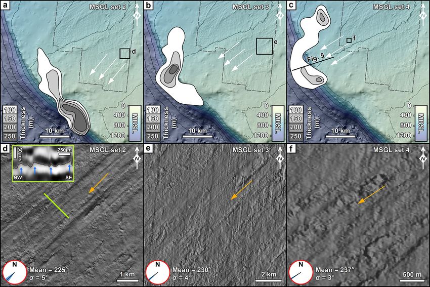
A. M. W. Newton et al.: Repeated ice streaming on the northwest Greenland continental shelf 2305
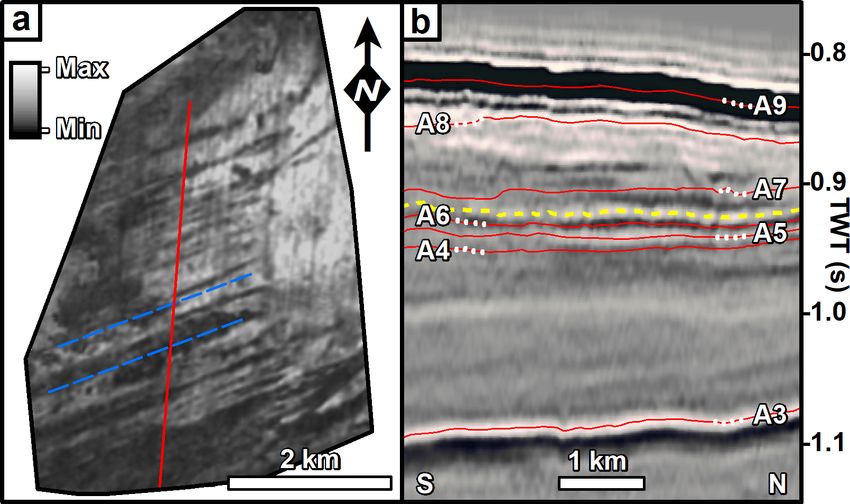
Figure 2. Seismic cross-section profiles through the glacigenic succession. The fan comprises 11 seismic stratigraphic units bounded by
glacigenic unconformities formed since ∼ 2.7 Ma (Knutz et al., 2019). The tentative chronology from Knutz et al. (2019) suggests that
the palaeo-seafloor surfaces preserved within units A7–A9 likely cover a time period from ∼ 1.3 to 0.43 Ma. This time period captures
much of the Middle Pleistocene (781–126 ka) and the transition into it from ∼ 1.3 Ma. Locations of the lines are shown in Fig. 1. TWT is
two-way-travel time. Interpreted and uninterpreted seismic lines are provided in the Supplement.
ern part of the trough, topset preservation is limited due to guide interpretation (e.g. Dowdeswell et al., 2016). Where
more recent glacial erosion that has cut into the substrate possible, using the velocity model of Knutz et al. (2019),
(Fig. 2a), whereas in the south there is better preservation thickness maps were created for subunits derived from de-
of aggradational topset strata (Fig. 2b) – i.e. palaeo-shelves posits that were stratigraphically linked to surfaces contain-
where buried landforms might be found. ing glacigenic landforms – e.g. correlative slope deposits on-
lapping the profile of the glacially influenced clinoform re-
flection. These depocentre maps can be used to document
3 Methods where sediments have been eroded and deposited, providing
insight into how depositional patterns may have changed in
This study used industry 3D and 2D seismic reflection data response to the evolution of ice stream pathways. In the ab-
from Melville Bugt, northwest Greenland (Fig. 1). The ver- sence of precise dating for each surface, the linear age model
tical resolution of the glacial succession is ∼ 10–15 m and of Knutz et al. (2019) has been used to relatively date glacial
the horizontal resolution ∼ 20–30 m – based on frequen- landforms identified in the different prograding units.
cies of ∼ 30–50 Hz and a sound velocity of ∼ 2–2.2 km s−1 .
Horizons were picked from within the 3D seismic data as
part of a seismic geomorphological analysis (Posamentier, 4 Subglacial landforms
2004), and gridded as 25 m × 25 m two-way-travel time sur-
face maps – i.e. buried palaeo-seafloor maps. It is impor- Seismic geomorphological analysis of topset strata imaged
tant to note that unlike traditional seafloor studies carried in the 3D data showed four sets of buried streamlined fea-
out on bathymetric data, these palaeo-seafloor surfaces will tures 5–15 km long and 200–300 m wide (Figs. 3 and 4).
have subsided and compacted since being buried. This means The landforms are typically 10–15 m high and although they
that landform thicknesses likely represent a minimum esti- are close to vertical seismic resolution limits (meaning that
mate of their original morphology. Seismic attributes, includ- cross-sectional profiles are subtle), they are best observed in
ing variance and root-mean-square (RMS) amplitude, were planform using the RMS amplitude or hillshaded surfaces.
extracted across the surfaces to aid in visualising architec- The streamlined features display a parallel concordance and
tural elements and landforms. This study focused on iden- are confined to individual palaeo-shelf layers within separate
tifying glacial landforms and used published examples to stratigraphic units, and their trend cross-cuts acquisition lines
https://doi.org/10.5194/tc-14-2303-2020 The Cryosphere, 14, 2303–2312, 2020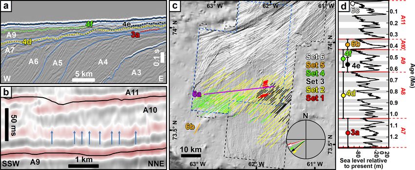
2306                           A. M. W. Newton et al.: Repeated ice streaming on the northwest Greenland continental shelf

                                                                            Although the 3D seismic data do not cover the distal part
                                                                         of the succession, by using examples of MSGLs that have
                                                                         been observed in 3D (Figs. 3, 4), the 2D seismic data were
                                                                         investigated for similar cross-sectional features. In unit A10
                                                                         (∼ 0.45–0.35 Ma) a reflection on the outer continental shelf
                                                                         shows a similar corrugated morphology, with heights of 10–
                                                                         15 m and widths of 200–300 m, to the MSGL pattern ob-
                                                                         served in the 3D data (Fig. 6b). The MSGLs documented
                                                                         in the 3D data also show that ice previously flowed towards
                                                                         this general area (Fig. 6c). The interpretation of the corru-
                                                                         gated features as MSGL set 5 is less robust due to the lack
                                                                         of 3D data, and whilst it is not possible to unequivocally
Figure 3. (a) MSGL set 1, the oldest example of mega-scale glacial       rule out that these features are something else, such as ice-
lineations (dashed blue lines), displayed as an RMS image observed       berg scours, an interpretation of MSGLs is supported by the
from 3D seismic reflection data and within unit A7 (b). The colour       location of these features in topset strata above the glacial
bar shows the maximum and minimum RMS values. Note that this             unconformity that marks the top of unit A9, suggesting the
surface is only partially preserved due to subsequent glacial erosion.   presence of grounded and erosive ice on the outer continental
For location see Fig. 1. (b) Seismic cross-section profile showing       shelf, conditions generally associated with MSGL formation.
the stratigraphic position (dashed yellow line) of the surface imaged       The final set of MSGLs (set 6) is observed in unit A11
in panel (a). The red lines show the top surface of each unit in the     (∼ 0.35–0 Ma) on the seafloor and provides evidence for a
glacigenic succession, and the dashed white lines are to help match
                                                                         grounded ice stream on the outer continental shelf at the
the labels to surfaces in this condensed stratigraphy. The location
of the cross-section profile is shown by the red line on panel (a).
                                                                         LGM (Newton et al., 2017; Fig. 6c). These MSGLs show
Interpreted and uninterpreted seismic lines are provided in the Sup-     cross-cutting evidence that allow for changes in ice flow pat-
plement.                                                                 terns to be deduced. The oldest MSGLs on the seafloor sug-
                                                                         gest an ice flow towards the west-southwest that is parallel to
                                                                         the axis of the trough, whilst the younger MSGLs (i.e. those
obliquely (Figs. 3 and 4). These features are interpreted as             which cross-cut the older MSGLs) show an ice flow towards
MSGLs due to their morphology (Spagnolo et al., 2014) and                the south-southwest, suggesting a change in ice flow during
similarity to MSGLs observed on the local seafloor (Newton               deglaciation (Newton et al., 2017).
et al., 2017) and buried on other glaciated margins (e.g. An-
dreassen et al., 2007; Dowdeswell et al., 2006; Montelli et
al., 2017; Rea et al., 2018).                                            5   Palaeo-ice streams
   MSGL set 1 is the oldest and is observed with an orien-
tation of 254◦ on a partially preserved surface in the lowest            The previous lack of 3D seismic data coverage means that
part of a thinly developed topset section of unit A7 (∼ 1.3–             prior to this study, ice stream landforms have not been ob-
1.05 Ma; Fig. 3). It was not possible to confidently deter-              served for glacials preceding the LGM on the Greenland mar-
mine correlative slope deposits and the associated depocentre            gin. Information on past ice flow patterns has, therefore, re-
due to the limited spatial extent of their preservation. Rising          lied upon broad inferences from depocentre locations – i.e.
through the stratigraphy, MSGL set 2 is observed in the up-              areas where large volumes of sediment are associated with
per part of unit A8 (∼ 1.05–0.65 Ma; Fig. 4a, d), and the as-            the general pathway of ice streams. Using the new seismic
sociated depocentre is located in the southwestern part of the           data, six sets of ice stream landforms have been documented
study area and measures up to 250 m thick. All of the subunit            – one on the seafloor, four buried surfaces imaged in 3D, and
depocentres show sediment thicknesses greater than 100 m                 one captured in the 2D seismic data. The MSGL sets pro-
and have been mapped from the slope deposits that are cor-               vide evidence for multiple ice-streaming events on the north-
relative to the adjacent palaeo-shelves. The slope deposits are          west Greenland continental shelf prior to, and including, the
typically comprised of onlapping chaotic seismic packages                LGM. Limited chronological constraints are currently avail-
interpreted as stacked glacigenic debrites (Fig. 5; Vorren et            able to determine exact timings, but the available chronology
al., 1989). MSGL set 2 has an average compass bearing of                 suggests these features formed during six glacial stages af-
225◦ (σ = 5◦ ) that aligns well with the maximum depocen-                ter ∼ 1.3 Ma (Knutz et al., 2019). Although no older MSGLs
tre thickness (Fig. 4a). MSGL sets 3 and 4 are observed on               have been imaged on palaeo-shelves captured in the available
separate surfaces preserved within the topset strata of unit A9          3D seismic data, ice streams are inferred to have operated in
(∼ 0.65–0.45 Ma; Fig. 4b, c, e, f), and their bearings show a            the area prior to ∼ 1.3 Ma, based on the large volumes of
gradual transition to 237◦ from the 225◦ observed in unit A8             sediment delivered to the margin (Knutz et al., 2019). It is
(Fig. 6).                                                                noteworthy that the first observations of MSGLs occur at the
                                                                         onset of a major change in the depositional patterns of the

The Cryosphere, 14, 2303–2312, 2020                                                         https://doi.org/10.5194/tc-14-2303-2020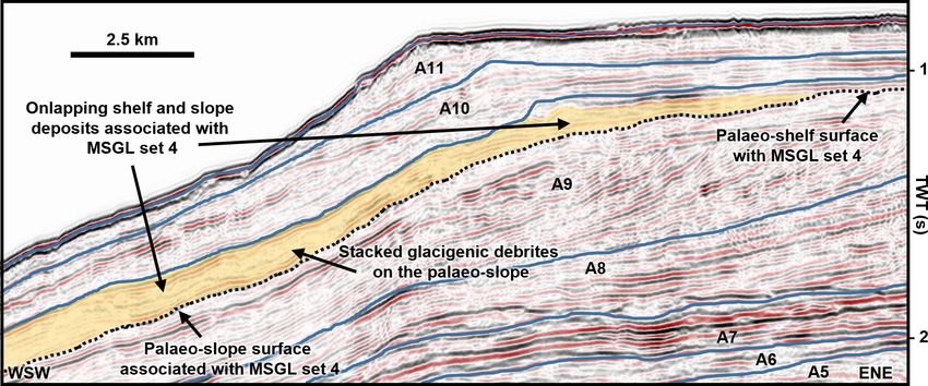
A. M. W. Newton et al.: Repeated ice streaming on the northwest Greenland continental shelf                                               2307

Figure 4. Buried MSGLs and associated TMF thickness maps. Panels (a) to (c) show the geographic location of MSGL sets 2–4 which
are displayed as hillshade images on panels (d) to (f). The dashed grey line on panels (a) to (c) is the 3D seismic survey outline overlain
on the contemporary seafloor; the white arrows show the inferred ice flow direction from the MSGLs, and the contoured outlines show the
thickness of the sedimentary deposit associated with MSGL sets 2–4. Orange arrows on panels (d) to (f) show the inferred ice flow direction.
On panel (d) the green line displays the location of the inset cross-section profile of the MSGL. Blue arrows point to the mounded features
visible on the hillshade image. The red circles in panels (d) to (f) display average MSGL compass bearings (black line) and the standard
deviation (surrounding blue fan) for each panel. Location of panels (a) to (c) shown in Fig. 1. The relative ages and stratigraphic positions of
each MSGL set are discussed in the text and labelled in Fig. 6.

Figure 5. Seismic cross-section profile showing the main glacigenic units and the palaeo-shelf surface (dotted line) where MSGL set 4 is
observed. Onlapping and stacked debrite packages are interpreted to be genetically linked to deposition caused by the ice stream that formed
this set of MSGLs and are used as an indicator of the broad depositional patterns displayed in Fig. 4c. Line location is shown in Fig. 4c.
Interpreted and uninterpreted seismic lines are provided in the Supplement.

https://doi.org/10.5194/tc-14-2303-2020                                                           The Cryosphere, 14, 2303–2312, 2020
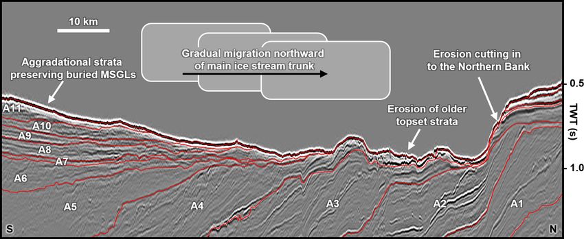
2308                          A. M. W. Newton et al.: Repeated ice streaming on the northwest Greenland continental shelf

Figure 6. (a) Seismic cross-section profile showing the stratigraphic location of the surfaces shown in Figs. 3 and 4. The blue lines are the
tops of the units shown in Fig. 2. The location of the lines is shown in panel (c). (b) Seismic cross-section profile from 2D seismic survey
showing evidence for potential MSGLs (blue arrows) in unit A10 on the outer continental shelf. Seismic line location is shown in panel (c).
(c) Digitised MSGL record from 3D seismic data. Set 6 represents the LGM record from Newton et al. (2017), and sets 1–5 are from the
current study. The compass shows the mean bearings for each set of MSGLs with the exception of set 5 because it is not captured in 3D.
(d) Possible age range for each MSGL surface observed within the glacigenic units of Knutz et al. (2019) and compared against the global
sea level record (Miller et al., 2011). Grey bands are glacial stages. Note that in all the panels, the surfaces (a), digitised MSGL (c), mean
flow bearings (c), and labels (d) are colour-coded to ease cross-referencing. Interpreted and uninterpreted seismic lines are provided in the
Supplement.

Melville Bugt and Upernavik TMFs. Unit A7 was deposited                  gration northward due to this deposition reducing the avail-
when the Melville Bugt and Upernavik TMFs combined to                    able accommodation for subsequent glacial stages (Fig. 7).
form an elongate depocentre up to 1 km thick. During the                 Thickness maps associated with MSGL sets 2–4 demonstrate
subsequent deposition of unit A8 the TMFs separated into                 this gradual, rather than extreme, shift in ice stream drainage
discrete depocentres up to 700 m thick, signalling a possible            pathways that is supported by 5–6◦ shifts in the mean orien-
reorganisation in ice flow in the region (Knutz et al., 2019).           tation of each MSGL set from 225◦ during unit A8 time, to
The reasons for this change are unresolved, but modification             237◦ during unit A9 time (Fig. 4). This shift continued at the
of the submarine topography brought about by glacigenic de-              LGM when the majority of MSGLs on the outer continental
position and erosion, such as is presented here, may have                shelf – except for some cross-cutting related to deglaciation
forced adjustments in the ice sheet flow on the outer conti-             (Newton et al., 2017) – shows a mean orientation of ∼ 248◦
nental shelf due to changes in available accommodation.                  (Fig. 6c).
   Switches in ice stream pathways on continental shelves be-               The partial preservation of the different palaeo-shelves
tween different glacial maxima have been observed on the                 means ice margin fanning on the less topographically con-
mid-Norwegian margin, where new cross-shelf troughs were                 fined outer continental shelf cannot be definitively ruled out
formed through the erosive action of ice (Dowdeswell et al.,             as an explanation for differing MSGL orientations. However,
2006). In contrast to the mid-Norwegian margin, the avail-               the observed metrics and depocentre migration provide com-
able data in Melville Bugt do not show evidence of buried                plementary evidence that this was in response to a gradual
cross-shelf troughs. The observations show changes in ice                migration of the main ice stream flow pathway – i.e. ice flow
stream pathways that appear to have occurred more gradu-                 pathways gradually moved northward in a clockwise pattern
ally between each MSGL set but remained focused within                   from unit A8 onwards (∼ 1 Ma). The gradual shift north-
the confines of the pre-existing trough. The longevity of the            ward of the main ice stream pathway and its associated ero-
Northern Bank and the significant overdeepening of the inner             sion meant that topset deposits in the south, with each pass-
trough (see Newton et al., 2017) likely provided consistent              ing glacial stage, were increasingly less impacted by the ice
topographic steering of ice streams on the inner continental             stream erosion, and therefore the landforms that they con-
shelf. On the outer continental shelf, deposition during the             tained had a better chance of being preserved through subse-
preceding glacial stage likely forced gradual ice stream mi-             quent glacial stages. The Melville Bugt Trough is the widest

The Cryosphere, 14, 2303–2312, 2020                                                            https://doi.org/10.5194/tc-14-2303-2020
A. M. W. Newton et al.: Repeated ice streaming on the northwest Greenland continental shelf                                                 2309

Figure 7. Interpreted seismic strike cross-section profile across the continental shelf showing spatially variable preservation of topset deposits
associated with the main depositional units. This variable preservation is thought to relate to the gradual migration of the ice stream away
from the areas of higher topography that contain the aggradational strata. This northward migration of the ice stream pathways is also
reflected by the erosion of the southern flank of the Northern Bank. Location of the line is shown in Fig. 1. Interpreted and uninterpreted
seismic lines are provided in the Supplement.

in Greenland (Newton et al., 2017), and it is possible that                sek, 2002). MPT ice sheet expansions have been documented
the preservation of these topsets is a consequence of this.                in the Barents Sea (Mattingsdal et al., 2014), on the mid-
The preservation suggests that whilst the main palaeo-ice                  Norwegian margin (Newton and Huuse, 2017), in the North
stream trunks associated with each glacial stage were accom-               Sea (Rea et al., 2018), and in North America (Balco and
modated within the broad confines of the trough, the fast-                 Rovey, 2010), highlighting a response of all major Northern
flowing and most erosive ice did not occupy its full width                 Hemisphere ice sheets to a currently unresolved climate forc-
– e.g. there are no MSGLs present for the LGM (set 6) in                   ing. Although ice streaming in Melville Bugt continued after
the southern part of the trough. The northward migration of                the MPT and through to the latest Pleistocene, some studies
the main ice stream pathway is also reflected by erosion and               from lower-latitude areas of west and east Greenland show
cutting into the deposits of the Northern Bank (Fig. 7). Al-               reduced ice stream erosion and deposition at this time (Hof-
though ice stream margin fanning or changes in upstream ice                mann et al., 2016; Pérez et al., 2018), perhaps suggesting the
sheet controls cannot be ruled out, the gradual depocentre                 high-latitude locality of Melville Bugt or the overdeepened
and MSGL migration suggests that deposition during suc-                    and bottlenecked geometry (topographic constraints) of the
cessive glacial stages may have been sufficient to bring about             inner trough (Newton et al., 2017) helped promote conditions
small changes in flow directions and subsequent depositional               favourable for ice streaming.
patterns. Future ice sheet modelling can contribute to this                   The MSGL record presented here provides some addi-
discussion by exploring whether ice volume over northern                   tional insight into the contradictory records on the longevity
Greenland would have been sufficient to maintain ice flux if               of the GrIS. Schaefer et al. (2016) showed that cosmogenic
the ice streams occupied the full width of the Melville Bugt               signatures require ice-free periods during the Pleistocene and
Trough. To a lesser extent, it is possible that the Melville               whilst these ice-free periods need not have occurred since
Bugt Ridge, an underlying tectonic structure which has pre-                1.1 Ma, ice sheet loss could have occurred during or after the
viously generated accommodation in the southern part of                    MPT. Ice stream evolution has been shown to have led to
the basin through differential subsidence (Cox et al., 2020;               rapid ice sheet changes on other ancient ice sheets (Sejrup
Knutz et al., 2019), could have contributed to reducing po-                et al., 2016), and given that ∼ 16 % of the GrIS currently
tential erosion of aggradational topsets by increasing palaeo-             drains into Melville Bugt (Rignot and Mouginot, 2012) the
water depths to the point where ice grounding was signifi-                 ice streams documented here could have contributed to ma-
cantly reduced or removed.                                                 jor changes in ice sheet organisation and extent – indeed,
   In the wider context of the whole GrIS, in east Green-                  the numerical model used by Schaefer et al. (2016) requires
land, sedimentological and geophysical evidence suggests                   the early loss of the northwest GrIS during ice sheet col-
that early in the Middle Pleistocene Transition (MPT –                     lapse. Fully resolving issues like this requires numerical ice
∼ 1.3 to 0.7 Ma) ice advanced across the continental shelf                 sheet models that are capable of reproducing fragmented
(Laberg et al., 2018; Pérez et al., 2019), whilst offshore                 geological evidence. For example, recent modelling explor-
southern Greenland documentation of increased ice-rafted                   ing Pleistocene climate evolution (Willeit et al., 2019) pro-
detritus suggests a similar ice advance (St. John and Kris-                vides palaeo-geographic maps of ice sheet extent that do not

https://doi.org/10.5194/tc-14-2303-2020                                                            The Cryosphere, 14, 2303–2312, 2020
2310                           A. M. W. Newton et al.: Repeated ice streaming on the northwest Greenland continental shelf

capture the ice sheet extent inferred from buried landform                Acknowledgements. Andrew M. W. Newton was supported by the
records on many glaciated margins (e.g. Rea et al., 2018), in-            Natural Environment Research Council (NERC) and Cairn Energy.
cluding Melville Bugt. Thus, there is currently a mismatch                David R. Cox was supported by NERC and the British Geological
between modelling outputs and landform records. If these                  Survey. Schlumberger and Esri are thanked for Petrel and ArcGIS
models are not able to recreate ice sheet extent, ice stream lo-          software. All authors thank Cairn Energy and Shell for data and
                                                                          permission to publish. Simon H. Brocklehurst is thanked for pre-
cations, and flow pathways that have been extracted from the
                                                                          reviewing this work and offering valuable insights. Brice R. Rea,
geological record, then those models will require refinement              Lara F. Perez, the anonymous reviewer, and the editor Pippa White-
before they can be used as a tool for projecting future GrIS              house are thanked for helpful comments and handling of the
evolution. These potential discrepancies underline how geo-               manuscript.
logical records, such as those presented here, provide crucial
empirical constraints for modelling the GrIS across multiple
glacial–interglacial cycles.                                              Financial support. This research has been supported by the Natu-
                                                                          ral Environment Research Council (grant nos. NE/K500859/1 and
                                                                          NE/M00578X/1), Cairn Energy, and the British Geological Survey.
6   Conclusions

This study provides a seismic geomorphological analysis off-              Review statement. This paper was edited by Pippa Whitehouse and
shore northwest Greenland and documents, for the first time,              reviewed by Lara Perez and one anonymous referee.
several sets of buried MSGLs on the Greenland margin. The
observation of different MSGL sets in separate stratigraphic
layers confirms the presence of fast-flowing ice streams dur-
ing at least six glacial maxima since the onset of the Middle             References
Pleistocene Transition at ∼ 1.3 Ma. These landform records                Andreassen, K., Ødegaard, C. M., and Rafaelsen, B.: Imprints of
show that grounded and fast-flowing ice advanced across                     former ice streams, imaged and interpreted using industry three-
the continental shelf to the palaeo-shelf edge of northwest                 dimensional seismic data from the south-western Barents Sea,
Greenland, with each subsequent ice stream flow pathway                     in: Seismic geomorphology: applications to hydrocarbon explo-
being partly controlled by the deposits left behind by the                  ration and production, edited by: Davies, R. J., Posamentier, H.
ice streams that preceded it. This represents a first spatio-               W., Wood, L. W., and Cartwright, J. A., Geological Society Spe-
temporal insight into sediment deposition and ice flow dy-                  cial Publication, London, UK, 151–169, 2007.
namics of individual ice streams during glacial maxima since              Arndt, J. E., Jokat, W., and Dorschel, B.: The last glaciation and
∼ 1.3 Ma in Melville Bugt. These results help to further em-                deglaciation of the Northeast Greenland continental shelf re-
phasise why northwest Greenland would be suitable for fu-                   vealed by hydro-acoustic data, Quaternary Sci. Rev., 160, 45–56,
                                                                            https://doi.org/10.1016/j.quascirev.2017.01.018, 2017.
ture ocean drilling that will help to elucidate ice sheet and
                                                                          Balco, G. and Rovey, C. W.: Absolute chronology for major Pleis-
climate history of the region.                                              tocene advances of the laurentide ice Sheet, Geology, 38, 795–
                                                                            798, https://doi.org/10.1130/G30946.1, 2010.
                                                                          Bennett, M. R.: Ice streams as the arteries of an ice sheet: Their
Data availability. The Geological Survey of Denmark and Green-              mechanics, stability and significance, Earth-Sci. Rev., 61, 309–
land or the authors should be contacted to discuss access to the raw        339, https://doi.org/10.1016/S0012-8252(02)00130-7, 2003.
seismic reflection data.                                                  Bierman, P. R., Shakun, J. D., Corbett, L. B., Zimmerman, S. R.,
                                                                            and Rood, D. H.: A persistent and dynamic East Greenland Ice
                                                                            Sheet over the past 7.5 million years, Nature, 540, 256–260,
Supplement. The supplement related to this article is available on-         https://doi.org/10.1038/nature20147, 2016.
line at: https://doi.org/10.5194/tc-14-2303-2020-supplement.              Christ, A. J., Bierman, P. R., Knutz, P. C., Corbett, L. B., Fos-
                                                                            dick, J. C., Thomas, E. K., Cowling, O. C., Hidy, A. J., and Caf-
                                                                            fee, M. W.: The Northwestern Greenland Ice Sheet During The
Author contributions. AMWN led the study by carrying out the                Early Pleistocene Was Similar To Today, Geophys. Res. Lett., 47,
seismic geomorphological analysis, drafting the figures, and writing        e2019GL085176, https://doi.org/10.1029/2019GL085176, 2020.
the initial text. All other authors contributed by offering feedback on   Clark, C. D.: Mega-scale glacial lineations and cross-cutting
the interpretations and editing the draft manuscript.                       ice-flow landforms, Earth Surf. Proc. Land., 18, 1–29,
                                                                            https://doi.org/10.1002/esp.3290180102, 1993.
                                                                          Clark, C. D., Tulaczyk, S. M., Stokes, C. R., and Canals, M.: A
Competing interests. The authors declare that they have no conflict         groove-ploughing theory for the production of mega-scale glacial
of interest.                                                                lineations, and implications for ice-stream mechanics, J. Glaciol.,
                                                                            49, 240–256, https://doi.org/10.3189/172756503781830719,
                                                                            2003.
                                                                          Cox, D. R., Huuse, M., Newton, A. M. W., Gannon, P., and Clay-
                                                                            burn, J. A. P.: Slip Sliding Away: Enigma of Large Sandy

The Cryosphere, 14, 2303–2312, 2020                                                            https://doi.org/10.5194/tc-14-2303-2020
A. M. W. Newton et al.: Repeated ice streaming on the northwest Greenland continental shelf 2311
Blocks within a Gas Bearing Mass Transport Deposit, Offshore Canyon, Norwegian Sea, Mar. Geol., 246, 68–85,
NW Greenland, Am. Assoc. Petr. Geol. B., 104, 1011–1044, https://doi.org/10.1016/j.margeo.2007.01.009, 2007.
https://doi.org/10.1306/10031919011, 2020. Laberg, J. S., Rydningen, T. A., Forwick, M., and Husum, K.: De-
Dowdeswell, J. A., Ottesen, D., and Rise, L.: Flow switching and positional processes on the distal Scoresby Trough Mouth Fan
large-scale deposition by ice streams draining former ice sheets, (ODP Site 987): Implications for the Pleistocene evolution of the
Geology, 34, 313–316, https://doi.org/10.1130/G22253.1, 2006. Scoresby Sund Sector of the Greenland Ice Sheet, Mar. Geol.,
Dowdeswell, J. A., Ottesen, D., and Rise, L.: Rates of sediment 402, 51–59, https://doi.org/10.1016/j.margeo.2017.11.018, 2018.
delivery from the Fennoscandian Ice Sheet through an ice age, Mattingsdal, R., Knies, J., Andreassen, K., Fabian, K.,
Geology, 38, 3–6, https://doi.org/10.1130/G25523.1, 2010. Husum, K., Grøsfjeld, K., and De Schepper, S.: A
Dowdeswell, J. A., Canals, M., Jakobsson, M., Todd, B. J., new 6 Myr stratigraphic framework for the Atlantic-
Dowdeswell, E. K., and Hogan, K. A.: Atlas of Submarine Arctic Gateway, Quaternary Sci. Rev., 92, 170–178,
Glacial landforms: Modern, Quaternary and Ancient, Geological https://doi.org/10.1016/j.quascirev.2013.08.022, 2014.
Society of London, London, UK, 2016. Miller, K., Mountain, G., Wright, J., and Browning, J.:
Funder, S., Kjeldsen, K. K., Kjær, K. H., and O Cofaigh, C.: The A 180-Million-Year Record of Sea Level and Ice Vol-
Greenland Ice Sheet During the Past 300 000 Years: A Review, ume Variations from Continental Margin and Deep-
in: Developments in Quaternary Science, edited by: Ehlers, J., Sea Isotopic Records, Oceanography, 24, 40–53,
Gibbard, P. L., and Hughes, P. D., Elsevier, Amsterdam, the https://doi.org/10.5670/oceanog.2011.26, 2011.
Netherlands, 699–713, 2011. Montelli, A., Dowdeswell, J. A., Ottesen, D., and Jo-
Hofmann, J. C., Knutz, P. C., Nielsen, T., and Kuijpers, A.: Seismic hansen, S. E.: Ice-sheet dynamics through the Quater-
architecture and evolution of the Disko Bay trough-mouth fan, nary on the mid-Norwegian continental margin inferred
central West Greenland margin, Quaternary Sci. Rev., 147, 69– from 3D seismic data, Mar. Petrol. Geol., 80, 228–242,
90, https://doi.org/10.1016/j.quascirev.2016.05.019, 2016. https://doi.org/10.1016/j.marpetgeo.2016.12.002, 2017.
Hogan, K. A., Ó Cofaigh, C., Jennings, A. E., Dowdeswell, J. A., Mouginot, J., Rignot, E., Bjørk, A. A., van den Broeke, M., Mil-
and Hiemstra, J. F.: Deglaciation of a major palaeo-ice stream in lan, R., Morlighem, M., Noël, B., Scheuchl, B., and Wood,
Disko Trough, West Greenland, Quaternary Sci. Rev., 147, 5–26, M.: Forty-six years of Greenland Ice Sheet mass balance from
https://doi.org/10.1016/j.quascirev.2016.01.018, 2016. 1972 to 2018, P. Natl. Acad. Sci. USA, 116, 9239–9244,
Jakobsson, M., Mayer, L., Coakley, B., Dowdeswell, J. A., Forbes, https://doi.org/10.1073/pnas.1904242116, 2019.
S., Fridman, B., Hodnesdal, H., Noormets, R., Pedersen, R., Newton, A. M. W. and Huuse, M.: Late Cenozoic environmental
Rebesco, M., Schenke, H. W., Zarayskaya, Y., Accettella, D., changes along the Norwegian margin, Mar. Geol., 393, 216–244,
Armstrong, A., Anderson, R. M., Bienhoff, P., Camerlenghi, A., https://doi.org/10.1016/j.margeo.2017.05.004, 2017.
Church, I., Edwards, M., Gardner, J. V., Hall, J. K., Hell, B., Newton, A. M. W., Knutz, P. C., Huuse, M., Gannon, P.,
Hestvik, O., Kristoffersen, Y., Marcussen, C., Mohammad, R., Brocklehurst, S. H., Clausen, O. R., and Gong, Y.: Ice
Mosher, D., Nghiem, S. V., Pedrosa, M. T., Travaglini, P. G., and stream reorganization and glacial retreat on the north-
Weatherall, P.: The International Bathymetric Chart of the Arctic west Greenland shelf, Geophys. Res. Lett., 44, 7826–7835,
Ocean (IBCAO) Version 3.0, Geophys. Res. Lett., 39, L12609, https://doi.org/10.1002/2017GL073690, 2017.
https://doi.org/10.1029/2012GL052219, 2012. Ó Cofaigh, C., Taylor, J., Dowdeswell, J. A., and Pudsey,
Jennings, A. E., Walton, M. E., Ó Cofaigh, C., Kilfeather, C. J.: Palaeo-ice streams, trough mouth fans and high-
A., Andrews, J. T., Ortiz, J. D., De Vernal, A., and latitude continental slope sedimentation, Boreas, 32, 37–55,
Dowdeswell, J. A.: Paleoenvironments during Younger Dryas- https://doi.org/10.1080/03009480310001858, 2003.
Early Holocene retreat of the Greenland Ice Sheet from outer Pérez, L. F., Nielsen, T., Knutz, P. C., Kuijpers, A., and
Disko Trough, central west Greenland, J. Quaternary Sci., 29, Damm, V.: Large-scale evolution of the central-east
27–40, https://doi.org/10.1002/jqs.2652, 2014. Greenland margin: New insights to the North Atlantic
Joughin, I., Smith, B. E., Howat, I. M., Scambos, T., glaciation history, Global Planet. Change, 163, 141–157,
and Moon, T.: Greenland flow variability from ice- https://doi.org/10.1016/j.gloplacha.2017.12.010, 2018.
sheet-wide velocity mapping, J. Glaciol., 56, 415–430, Pérez, L. F., Nielsen, T., Rasmussen, T. L., and Winsborrow, M.:
https://doi.org/10.3189/002214310792447734, 2010. Quaternary interaction of cryospheric and oceanographic pro-
King, E. C., Hindmarsh, R. C. A., and Stokes, C. R.: For- cesses along the central-east Greenland margin, Boreas, 48, 72–
mation of mega-scale glacial lineations observed beneath 91, https://doi.org/10.1111/bor.12340, 2019.
a West Antarctic ice stream, Nat. Geosci., 2, 585–588, Posamentier, H. W.: Seismic Geomorphology: Imaging Elements of
https://doi.org/10.1038/ngeo581, 2009. Depositional Systems from Shelf to Deep Basin Using 3D Seis-
Knutz, P. C., Newton, A. M. W., Hopper, J. R., Huuse, mic Data: Implications for Exploration and Development, in: 3D
M., Gregersen, U., Sheldon, E., and Dybkjær, K.: Eleven Seismic Technology: Application to the Exploration of Sedimen-
phases of Greenland Ice Sheet shelf-edge advance over tary Basins, edited by: Davies, R. J., Cartwright, J. A., Stewart,
the past 2.7 million years, Nat. Geosci., 12, 361–368, S. A., Lappin, M., and Underhill, J. R., Geological Society of
https://doi.org/10.1038/s41561-019-0340-8, 2019. London, London, UK, 11–24, 2004.
Laberg, J. S., Guidard, S., Mienert, J., Vorren, T. O., Hafl- Rea, B. R., Newton, A. M. W., Lamb, R. M., Harding, R., Bigg, G.
idason, H., and Nygård, A.: Morphology and mor- R., Rose, P., Spagnolo, M., Huuse, M., Cater, J. M. L., Archer,
phogenesis of a high-latitude canyon; the Andøya S., Buckley, F., Halliyeva, M., Huuse, J., Cornwell, D. G., Brock-
lehurst, S. H., and Howell, J. A.: Extensive marine-terminating
https://doi.org/10.5194/tc-14-2303-2020 The Cryosphere, 14, 2303–2312, 20202312 A. M. W. Newton et al.: Repeated ice streaming on the northwest Greenland continental shelf ice sheets in Europe from 2.5 million years ago, Sci. Adv., 4, Spagnolo, M., Phillips, E., Piotrowski, J. A., Rea, B. R., Clark, eaar8327, https://doi.org/10.1126/sciadv.aar8327, 2018. C. D., Stokes, C. R., Carr, S. J., Ely, J. C., Ribolini, A., Rignot, E. and Mouginot, J.: Ice flow in Greenland for the Interna- Wysota, W., and Szuman, I.: Ice stream motion facilitated by a tional Polar Year 2008-2009, Geophys. Res. Lett., 39, L11501, shallow-deforming and accreting bed, Nat. Commun., 7, 10723, https://doi.org/10.1029/2012GL051634, 2012. https://doi.org/10.1038/ncomms10723, 2016. Schaefer, J. M., Finkel, R. C., Balco, G., Alley, R. B., Caf- St. John, K. E. K. and Krissek, L. A.: The late Miocene to fee, M. W., Briner, J. P., Young, N. E., Gow, A. J., Pleistocene ice-rafting history of Southeast Greenland, Boreas, and Schwartz, R.: Greenland was nearly ice-free for ex- 31, 28–35, https://doi.org/10.1111/j.1502-3885.2002.tb01053.x, tended periods during the Pleistocene, Nature, 540, 252–255, 2002. https://doi.org/10.1038/nature20146, 2016. Tan, N., Ladant, J. B., Ramstein, G., Dumas, C., Bachem, P., and Sejrup, H. P., Clark, C. D., and Hjelstuen, B. O.: Rapid Jansen, E.: Dynamic Greenland ice sheet driven by pCO2 varia- ice sheet retreat triggered by ice stream debuttressing: tions across the Pliocene Pleistocene transition, Nat. Commun., Evidence from the North Sea, Geology, 44, 355–358, 9, 4755, https://doi.org/10.1038/s41467-018-07206-w, 2018. https://doi.org/10.1130/G37652.1, 2016. Vasskog, K., Langebroek, P. M., Andrews, J. T., Nilsen, J. E. Sheldon, C., Jennings, A., Andrews, J. T., Ó Cofaigh, C., Hogan, K., Ø., and Nesje, A.: The Greenland Ice Sheet during the last Dowdeswell, J. A., and Seidenkrantz, M. S.: Ice stream retreat glacial cycle: Current ice loss and contribution to sea-level rise following the LGM and onset of the west Greenland current in from a palaeoclimatic perspective, Earth-Sci. Rev., 150, 45–67, Uummannaq Trough, west Greenland, Quaternary Sci. Rev., 147, https://doi.org/10.1016/j.earscirev.2015.07.006, 2015. 27–46, https://doi.org/10.1016/j.quascirev.2016.01.019, 2016. Vorren, T. O. and Laberg, J. S.: Trough mouth fans - Palaeocli- Slabon, P., Dorschel, B., Jokat, W., Myklebust, R., Hebbeln, mate and ice-sheet monitors, Quaternary Sci. Rev., 16, 865–881, D., and Gebhardt, C.: Greenland ice sheet retreat https://doi.org/10.1016/S0277-3791(97)00003-6, 1997. history in the northeast Baffin Bay based on high- Vorren, T. O., Lebesbye, E., Andreassen, K., and Larsen, K. resolution bathymetry, Quaternary Sci. Rev., 154, 182–198, B.: Glacigenic sediments on a passive continental margin as https://doi.org/10.1016/j.quascirev.2016.10.022, 2016. exemplified by the Barents Sea, Mar. Geol., 85, 251–272, Solgaard, A. M., Reeh, N., Japsen, P., and Nielsen, T.: https://doi.org/10.1016/0025-3227(89)90156-4, 1989. Snapshots of the Greenland ice sheet configuration in the Willeit, M., Ganopolski, A., Calov, R., and Brovkin, V.: Mid- Pliocene to early Pleistocene, J. Glaciol., 57, 871–880, Pleistocene transition in glacial cycles explained by declin- https://doi.org/10.3189/002214311798043816, 2011. ing CO2 and regolith removal, Sci. Adv., 5, eaav7337, Spagnolo, M., Clark, C. D., Ely, J. C., Stokes, C. R., Anderson, J. https://doi.org/10.1126/sciadv.aav7337, 2019. B., Andreassen, K., Graham, A. G. C., and King, E. C.: Size, shape and spatial arrangement of mega-scale glacial lineations from a large and diverse dataset, Earth Surf. Proc. Land., 39, 1432–1448, https://doi.org/10.1002/esp.3532, 2014. The Cryosphere, 14, 2303–2312, 2020 https://doi.org/10.5194/tc-14-2303-2020
You can also read