Retaining Walls, Retaining History - An Interpretative Account of Richmond's Morphological Marker - Narratives in Space + ...
←
→
Page content transcription
If your browser does not render page correctly, please read the page content below
Retaining Walls, Retaining History
An Interpretative Account of Richmond’s Morphological Marker

                                                      Diego Maenza

                                        Independent Research Project
                                        Dr. Joseli Macedo, Supervisor
                                     Dr. Mikiko Terashima, Instructor
                                                          PLAN 6000
                                                    December 13, 2019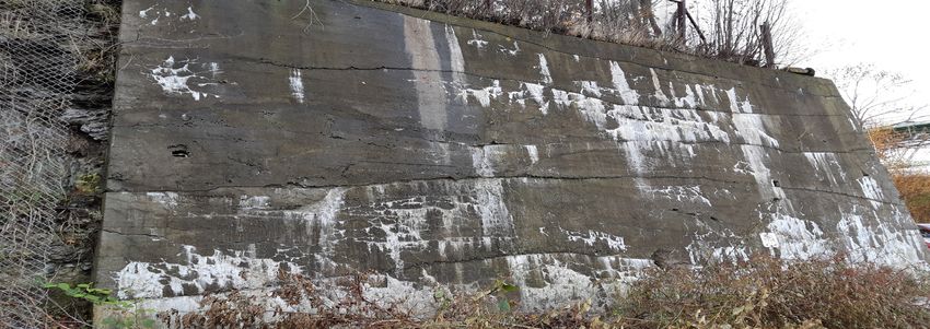
Page 2

Figure 1: Front cover - photograph of a painting of the Halifax Shipyards, 1919.
(Source: MacAskill, W.R., 1919. NSARM, no. 1987-453 no. 4703)
Page 3

Let’s walk along the wall and feel the passage of time...
Page 4

   Acknowledgements

          I would like to acknowledge everyone that helped support and contribute to my
   research findings. Thank you to both my supervisor and instructor, Dr. Joseli Macedo
   and Dr. Mikiko Terashima for your feedback, insight, and guidance. I would also like to
   thank Dr. Brian Lilley, Dr. Paul Erickson, and Professor James Boxall for their insights
   and knowledge of all things Halifax. I would also like to thank staff at the Maritime
   Museum of the Atlantic, the Naval Museum of Halifax, and the Public Archives of Nova
   Scotia for accommodating and providing me with a wealth of valuable information.
Page 5

Glossary of Abbreviations

ARGG - Applied Research Geomatics Group
CCCR - Canada’s Climate Change Report
CGR - Canadian Government Railways
CNR - Canadian National Railways
DND - Department of National Defence
HMC Dockyard - Her Majesty’s Canadian Dockyard
HRM - Halifax Regional Municipality
ICR - Intercolonial Railway
IMP - Integrated Mobility Plan
LIDAR - Light Detection and Ranging
MOVE - Movement for Citizens’ Action and Voice
NSARM - Nova Scotia Archives and Records Management
NSCC - Nova Scotia Community College
NSPS - Nova Scotia Planning Secretariat
PID - Premises Identification (number)
TNT - Trinitrotoluene (compound used in dynamite)
Page 6

  Executive Summary

         The crown jewel of Canada’s Atlantic coast for over two-hundred-and-fifty
  years, Halifax has a diverse, storied, and tragic history. Countless memories and stories
  lie underneath the city’s current urban fabric, unbeknownst to many. Halifax is a city
  with a palimpsest surface. Palimpsest is a term that refers to manuscripts of papyrus that
  historically were partially erased and written over countless times. It can also apply in
  an urbanist sense to the many diverse temporal and spatial layers underlying a location
  (Knox, 2012, p. 8). Every city has its own set of geographies: political, social, economic, and
  so on. Those attributes are expressed through a fabric of districts or neighbourhoods that
  each have a distinct identity and story. Each chapter of that story inevitably leaves its mark
  through sucessive cycles of development and decline. It is in the layering and imprint of
  urban structures, the cultures of the residents, the spatial changes of the street layout, and
  the institutions within each district where this overwriting becomes visible (Knox, 2012, p.
  9).                     Chapter I
                  Adobe InDesign
           Underneath a 1.5 kilometre section of Barrington Street near the HMC Dockyard
  lies a relic of the past that also plays a role in the present, and perhaps the future of the
  area. Not so readily apparent from the perspective of a motorist or pedestrian on the street
  itself, this massive urban structure is perhaps never on the minds of those that stand upon
  it. Aerial photographs, satellite imagery, and a view from the Angus L. Macdonald Bridge
  can be used to demonstrate the jarring difference in perspective between the street and the
  yards below.
          The retaining wall system between Cornwallis Street and the Irving Assembly Hall
  has seldom been recognized as an important feature of the North End. Indeed, concrete
  and stone masonry does not bring much to the imagination, but the contexts and periods
  of history within which the retaining wall system has stood are some of the most important
  in Halifax. Historical literature surrounding the history of the North End of Halifax rarely
  refers to the retaining wall system. In the midst of the development, destruction, and
  redevelopment of this area, the walls have remained as a morphological marker of the
  trajectory that the North End has been developing towards for over a century.
Page 7

Table of Contents

Introduction
Research Question..................................................................................................................9
Purpose and Objectives........................................................................................................11
Methods...............................................................................................................................12
Analysis...............................................................................................................................16
Limitations...........................................................................................................................17

The Retaining Wall System
Geographical Context............................................................................................................19
Wall Characteristics..............................................................................................................20

Chronological Timeline
Before 1854...........................................................................................................................33
1854-1877: The Railroad Enters Richmond...........................................................................33
1878-1900: Industry in Richmond........................................................................................36
1917: The Halifax Explosion..................................................................................................38
1918: Aftermath and Rebuilding............................................................................................39
After 1918: The Removal of Richmond...................................................................................42
1945-1975: Urban Renewal on Barrington Street..................................................................42
Chronological Timeline.........................................................................................................50

Present and Future Considerations
Retaining the Sea and the Land.............................................................................................52
Concluding Remarks.............................................................................................................67

References..........................................................................................................................68
Page 8

   Part 1:
   Introduction
Page 9

Introduction
                                                             Figure 2: Walking tour
                                                             at Irving Shipyards.

                                                             Walking tour of the retaining
                                                             wall system by the Narratives in
                                                             Space+Time Society in 2016.
                                                             (Source: Narratives in
                                                             Space+Time Society,
                                                             2016)

Sculpting the land...
        Retaining walls play a role as earth-retaining infrastructure (Hough, 2001, p. 217).
Retaining walls created in the Victorian-era up to the 1920s were mainly gravity-based
masonry or concrete walls which followed classical earth-pressure theory techniques
(Hough, 2001, p. 217). In the context of railway and road systems, they are used to
improve safety, improve track capacity, prevent against landslides or reduce steep
slope gradients (AREMA, 2014, p. 2) In Halifax, there stands a wall 1.5 kilometres in
length which runs from the intersection of Cornwallis Street and Upper Water Street to
the Irving Assembly Hall past North Street (Figure 1 & 2). Barrington Street (formerly
known as Campbell Road), sits on top, supported by the retaining wall. This area is part
of the North End, a historical working-class district which spans a history of over 250
years. Specifically, the area east of Gottingen Street and Novalea Drive over the steep
hill of Fort Needham was known as the industrial working-class suburb of Richmond,
where the wall stands today (Erickson, 1986, p. 12). From the early 1800s to the late
1910s, it was a separate suburb lying between North Street, Gottingen Street, and Duffus
Street (Blakeney, 1949, p. 63).
       In the midst of industrialization, war-time preparation, and the destruction of
Halifax’s North End, the retaining wall stands as one marker of Halifax’s industrial
and economic built-form growth through its connection to the railway, military, and
marine port infrastructure. Most of the literature discussing the Halifax Explosion,
the Intercolonial Railway, and about the history of the North End fails to mention the
retaining wall system due to its functional nature as railway infrastructure.
       To this end, I proposed the creation of an interpretive account of the retaining
wall in the context of Halifax’s railroad infrastructure and the subsequent periods of
great economic and built-form urban change that arose from the establishment of the
railroad, the aftermath of the Halifax Explosion in 1917, towards the 21st century and
implications of the future.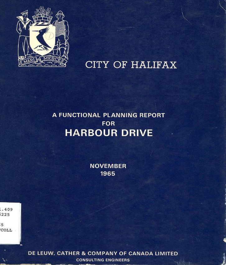
Page 10

   Research Questions

   What role did the retaining wall system along Barrington St. have in
   contributing to the economic, infrastructural, and built-form growth of
   Richmond between the mid-19th century and mid 20th century?

   Project Sub-questions
   Environmental
   • What are the topographical characteristics (elevation and slope) of the North End
     area?
   • How does acid-leaching pyritic slate impact the structural integrity of the wall?
   Economic and Infrastructural
   • What and who were the agents of change that facilitated the expansion of the
     railway, the configuration of the site, and construction of the walls from 1854 to
     1918?
   • How was the construction of the retaining wall financed?
   • What was the impact and relevance of the Federal Government’s National Policy
     (1879) on the industrial and infrastructural growth of the North End?
   Cultural and Built-Form
   • What opposition existed against the wall and construction of industrial port
     infrastructure?
   1917 Halifax Explosion
   • What was the physical impact of the explosion on the wall?
   • Who was contracted to repair the wall and how did it differ from the original?
   Present Day
   • What measures are being taken by the Halifax Regional Municipality, the
     Province of Nova Scotia, and the Department of National Defence in repairing and
     strengthening the wall?

   • How does this inform about future alterations to the wall?
Page 11
Purpose
The purpose of this historical research study was to provide an interpretive
account and a chronological timeline of the retaining wall within the historical context
of Richmond and Halifax. Doing so will have contributed to the historical knowledge
of Halifax and the North End area for residents, academics, and interest groups such
as the Narratives in Space+Time research society.
Research Objectives
• To compose a chronological timeline of key events involving the retaining wall in
the context of Richmond;
• To identify the agents of change that facilitated the expansion of the Intercolonial
Railway, industrial growth in Richmond, the configuration of the retaining wall
site, and construction of the wall sections from the mid-1800s to 1918;
• To assess the changes in built-form in Halifax’s Richmond suburb in the time period
from the mid-1800s to the mid-20th century as a means of providing historical
context;
• To contribute another chapter to the already-established historical knowledge
of Halifax and the North End area for residents, academics, and special interests
groups including the Narratives in Space+Time Society.Page 12
Methods
To achieve the research objectives, I utilized four methods of investigation.
1. Primary Source Evaluation
To compile a thorough base of knowledge and to expand upon my multi-
prong inquiry methods, numerous trips to provincial and municipal institutions
were necessary. The Nova Scotia Public Archives, the Halifax Regional Municipality
Archives, the Naval Museum of Halifax, the Maritime Museum of the Atlantic, and
the Dalhousie University library were the places that had the most information on
the retaining wall itself. Furthermore, newspaper articles from the Halifax Daily-
Star, Chronicle-Herald, as well as photographs, maps, atlases, deed records from the
Nova Scotia Registry of Deeds, military reports, city council documents, and technical
infrastructural documents from the Intercolonial Railway and Canadian Government
Railways were fundamental as primary and secondary documents. My aim was to
detail the timeframe, places, and people who were fundamental in the creation of the
retaining wall and associated railway infrastructure. From this, I was able to sculpt
a cohesive and strong narrative that ties into the wider context of Halifax and Nova
Scotia’s economy, infrastructure, and industry. It considered it beneficial that all
primary documents could be dated and traced to specific points in time.
I found and used microfiche and microfilm technology, as needed, as well as
consulted with archival staff like Garry Shutlak (Nova Scotia Archives) and Susan
McClure (HRM Archives) to further locate relevant documents. I gained significant
experience in deed and title searches through the NS Registry of Deeds Property
Online database and this helped me pinpoint the dates when land was purchased,
sold, expropriated, or when right-of-way was given. As I progressed, I believed I
needed to consult with relevant professionals and broaden my scope to include the
Library and Archives Canada, the HMC Dockyard, and the Halifax Military Heritage
Preservation Society. This is because I could not limit myself to online documentation.Page 13
2. Correspondence with Experts
Although extremely beneficial in providing support, documentation kept at
the Dalhousie Library, Public Archives of Nova Scotia, Halifax Regional Municipality
Archives, and other sources of primary and secondary data did not provide the explicit
contexts and information needed for understanding and plotting the trajectory of the
whole project.
Conversations with experts were used as a form of research gathering that
ended up being helpful. Communication via email and in-person with local historical
societies such as the Narratives in Space+Time Society, museum staff, academic
researchers, and public archivist staff helped inform me about the local Halifax and
North End contexts. Questions were semi-structured aned targeted in a way to clarify
and elaborate on the historical primary and secondary materials collected so far.
Contacts for this project included:
• Dr. Roger Marsters, Marine Curator, at the Maritime Museum of the Atlantic, who
had recently been researching the early shipyard site.
• Jennifer Gamble, director, she oversaw the Naval Museum of Halifax.
• Dr. Brian Lilley, professor, at the Dalhousie School of Architecture. He did much
of the preliminary research on the retailing wall system and discussed with the
Narratives in Space+Time Society about structural changes in the urban form
during their 2016 walking tour of the site.
• Dr. Ren Thomas, professor, at the Dalhousie School of Planning.
• Dr. Paul Erickson, author and professor of Archeology at Saint Mary’s University,.
He wrote many books on the history and archeology of the North End, such as
Historic Halifax’s North End (2004), and Halifax’s North End: An anthropologist looks
at the city (1986).
Conversations with experts took place on October 29, 2019 (Brian Lilley), November 3,
2019 (Paul Erickson), and November 25, 2019 (James Boxall).
Primary and secondary sources in the form of books, journal articles, photographs, and
maps were accessed through correspondence with Dr. Roger Marsters, at the Maritime
Museum of the Atlantic on October 30, 2019, and with Jennifer Gamble, at the Naval
Museum of Halifax on October 31, 2019.Page 14
3. Secondary Source Evaluation
To provide an overall context of the actions and processes that led to the
development and construction of the retaining wall, I needed to develop an
understanding of the economic, political, industrial, and infrastructural circumstances
within Halifax, Nova Scotia, and Canada from the mid-19th century to the mid-20th
century. I obtained numerous scholarly articles, books, and other documents from
the Dalhousie Library, the Public Archives of Nova Scotia, the Naval Museum of
Halifax, the Halifax Municipal Archives, and the Halifax Public Library. From these
documents, I discovered the socio-spatial relationship between the development
of critical infrastructures and the broader course of economic, infrastructural, and
built-form development that occurred in Halifax’s North End. Scholarly journals that
discussed major economic reforms and town planning at the time in Halifax were also
beneficial. I also noted that author Dr. Paul Erickson had written several books on the
growth of the North End (Historic Halifax’s North End (2004) & Halifax’s North End: An
anthropologist looks at the city (1986). His writing gave great insights to understanding
the history of the area.
4. Site Observation
Visible on Google Maps, the site lies on property owned by the HMC Dockyard
and Irving Shipbuilding. Some sections of the wall lie directly in the parking lot of
the HMC Dockyard, while other sections run behind the Irving Assembly Plant. As
the land is not owned by the Halifax Regional Municipality, I thought I needed to
ask for permission to do a site visit. I contacted the Director of Communications at
Irving Shipbuilding but received no response. By visiting the Naval Museum and
also looking at files from the Maritime Museum of the Atlantic, I learned that the
permit process to access the securitized area is lengthy and involves contacting the
Base Commander. I knew that the Narratives in Space+Time Society had done public
walking tours of the site itself in 2016. Therefore, I asked them for advice and support
regarding site access. I had taken some photographs of the retaining wall and the
Irving Shipyards site from the water during the summer months when I went on a
small heritage tour of the Narrows area and harbour. I also had to rely on second-
hand information and knowledge about the retaining wall site, particularly from the
Narratives in Space+Time Society as some members took pictures and recorded videos
which remain on their website.
Site observation occured on September 29, 2019, November 6, 2019, and December
1, 2019. It comprised of walks along both Valour Way and Barrington Street within the
vicinity of the retaining wall system. Outside of the securitized areas, the parking lots
of the HMC Dockyard and Irving Shipyards were somewhat accessible as agreements
between them and CN Rail grants a perpetual right-of-way as it was formerly used as
a railway corridor. Photographs were also taken from both sides of the pedestrian and
cycling lanes of the Angus L. Macdonald Bridge providing a stunning view of the site
and of the walls themselves.Page 15
Interpretative Historical Analysis
The method of analysis that I used is called Interpretive Historical Analysis.
Strictly speaking, all research involves the interpretation of data. However,
interpretive research is defined as, “investigations into social-physical phenomena
within complex contexts, with the aim of explaining those phenomena through a
holistic narrative form” (Groat, & Wang, 2013, pp. 222-223). This is an inductive method
of using data to create a rich descriptive narrative. The aim is to create a cohesive
narrative through which evidence can be weaved together. Social reality is shaped by
human experiences and contexts, therefore, the narrative created in this project must
be consistent with time-period relationships found in the Canadian and Haligonian
contexts of the mid-19th century to 1918. The research data acquired through primary
and secondary source evaluation will be used to interpret the retaining wall’s history
through determinative, recollective, inferential, and contextual evidence within that
timeframe (Groat & Wang, 2013, pp. 195-196, 198, 201-202). This is part of an iterative,
back-and-forth process of connecting fact to overall contexts to establish a grander
historical narrative. Finally, the need for verification is a check against inaccurate
narration. The triangulation of researched facts from different sources to a point
of convergence or agreement is critical, otherwise the veracity of any claims are
diminished (Groat & Wang, 2013, p. 84).
Limitations
Throughout the project, several limitations were experienced. Contact with
Irving Shipyards Ltd. and the HMC Dockyard staff was unsuccessful in getting access for
some parts of the site. As well, no help was provided from staff at the HMC Dockyard or
Irving Shipyards regarding information about the site or the retaining walls themselves.
In correspondence with Dr. Lilley, he mentioned that the parking lot areas of
the HMC Dockyard and Irving Shipyard sites were accessed by the walking tour of the
Narratives in Space+Time Society. He remarked that it was located directly outside of the
securitized areas. Therefore, parts of the retaining wall system were observed at various
dates and also from the pedestrian lane of the Angus L. Macdonald Bridge (Lilley,
personal communication, 2019).
During research on the numerous properties that were expropriated on Barrington
Street, I realized that interviews with former residents of that immediate area would
possibly have added another angle and more depth to the project. This came to mind
when looking for vintage archival photographs on a Facebook group called “OLD Black
and White Pictures of Halifax, Nova Scotia” there were many comments from former
residents under photographs of Elevator Court, Bedford Court, and the HMC Dockyard.
They reminisced about the past and recalled events with suprising detail. Certainly, some
people may have had some knowledge about the retaining walls as well.Page 16 Part 2: The Retaining Wall System
Page 17

Geographical Context

        The retaining wall system lies within a 1.5 kilometre expanse between Cornwallis
Street and Duffus Street in the North End of Halifax Peninsula. It is bounded by the
deep Halifax Harbour, a crowded harbour that stretches for kilometres between hills
until it opens into Bedford Basin. It grew from the HMC Dockyard and Fort Needham
in the 1700 and early 1800s, as an agricultural area called Dutch Town expanded
(Figure 3). Eventually, Richmond became a part of the city in the North End around
Fort Needham and Mulgrave Park. From the early 1800s to the late 1910s, it was a
separate suburb lying between North Street, Gottingen Street, and Duffus Street. It
was called Richmond due to the vessels that brought flour from Richmond, Virginia
to the wharves near the present HMC Dockyard (Blakeney, 1949, p. 63).
       The area along Barrington Street between Richmond and the HMC Dockyard
was where many of the working-class residents of the city lived. Richmond grew from
a tiny agricultural and military settlement to a large and populous district of roughly
14,000 in 1901. Highly industrialized, it was where machine shops, iron foundries
and factories employed over one-hundred and fifty men (Blakeney, 1949, p. 4).

Figure 3: View of Halifax from Fort Needham Hill, 1801.
(Source: Parkyns, G.I., 1801, watercolour on canvas, The British Library)
Page 18
Wall Characteristics
Location
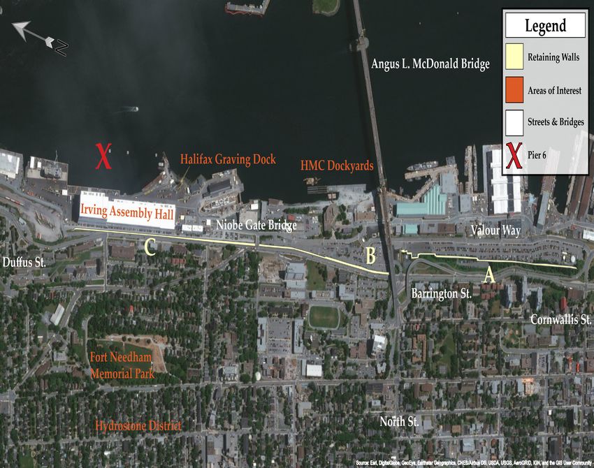
A series of retaining walls were built between Cornwallis and Duffus Streets. The
walls themselves were not built contiguously and thus they could be divided into
sections (Figure 4).
The first section (A) runs between the intersection of Cornwallis and Upper Water
Street along Valour Way.
The second section (B) runs between the intersection of North Street and the Niobe
Gate Bridge.
The third section (C) runs along Barrington Street from the Niobe Gate Bridge to the
end of the Irving Assembly Hall near Duffus Street.
Figure 4: Map of the retaining wall system (on next page). (Source: ESRI, 2019)Page 19
Page 20

    Topography
           The retaining wall structures lie on the eastward slope of Needham Hill in the
   North End. The hill itself is a steep glacial drumlin composed of silty soils. Citadel
   Hill and Georges Island are other drumlins that were valued militarily due to the
   ease of shaping the land and their commanding views (Ekistics & Form:Media, 2015,
   p. 12). The soils that the retaining walls hold back are of the Halifax Formation. It is
   composed of a brown sandy-loam till that has good internal drainage, and consists
   of granite and quartzite material. The topsoils are underlain by Precambrian pyritic
   slates native to Halifax (Ekistics & Form:Media, 2015, p. 32).
          As seen below, the 1969 contour map of the North End displays elevation
   values, building footprints, and modes of transportation (Figure 5). Highlighted
   in blue, some of the retaining wall sections are found at different elevations above
   sea level. The section along the parking area on Valour Way lies between 34-36 feet
   and 61-47 feet. The section along Barrington Street directly underneath the Angus L.
   Mcdonald Bridge lies between 61 feet and 78-80 feet. To the far right side of the map
   are the Dockyard facilities located at a much lower elevation. It indicates that the
   urban structure of much of this part of the North End is heavily terraced as to allow
   for the development of buildings and movement of goods and people.

   Figure 5: Contour map of of Barrington St, 1969 (retaining wall highlighted in blue).
   (Source: NS Department of Lands and Forests, 1969. City of Halifax, Sheet: 5N11-95-NE)
Page 21
Historical Material Composition of Retaining Walls in Halifax
Stone
Building stone refers to stone used in the construction of buildings and other
structures. It can be used for structural purposes, such as bearing heavy loads, or for
decoration as cladding or pavers (Dickie, 1993, p. 1). Stone has been used in Nova
Scotia in settlement-building since the 17th and 18th centuries. During those years,
some types of stone were acquired from ship ballast as ships moved from Halifax
to Europe and the West Indies. Ship ballast was often crushed stone used to provide
stability in ships, colloquially known as rip-rap (Dickie, 1993, pp. 5-6). This may
be seen as one of the first examples of adaptive re-use for infrastructure in the city.
Although much of the stone used in Nova Scotia came from quarries in Pictou County,
a majority of Halifax’s building stone came from Queen’s Quarry and King’s Quarry
at Purcell’s Cove. From the mid-1700s, Queens Quarry provided much of the granite
and ironstone used in the city (Dickie, 1993, pp. 5-6).
Ironstone is the colloquial name for a type of metamorphized slate found in the
Halifax area. It is formed from the alteration of clay sediments heated by the intrusion
of large swathes of granite (Parks, 1912, p. 209). Particles of iron pyrite are found in
the rock. Oxidation in the form of yellowish-brown stains occur through the passage
of time and due to weather. This type of stone was used in the construction of the
Halifax Citadel, Fort Charlotte, the earlier HMC Dockyard buildings and walls, and
other government works (Parks, 1912, pp. 209-210).
Dating from 1802, one of the earliest existing records of retaining walls
in Halifax is found at the HMC Dockyard site. It describes a motion from John N.
Inglefield, Naval Commissioner, to replace the wooden palisades and fortifications
with stone from Queen’s Quarry in the North West Arm (Figure 6). A barge would
be sent near the quarry site to obtain the stone and specialized naval workers which
included masons who would construct new defensive and retaining walls.
Concrete and Mortar
Portland cement was developed in England as a cheap and sturdy method of
joining bricks or stones together. The Mahone Bay sands were historically known for
their high-quality deposits of sand and gravel. During the mid to late 19th century, this
aggregate material was loaded onto schooners and shipped to Halifax where it was
turned into concrete, cement, and mortar. The Halifax Graving Dock was constructed in
1889 from Mahone Bay sands and gravels (Prime, 1993, pp. 2-3).Page 22 Figure 6: Record of an early retaining wall, 1802. (Source: Inglefield, J.N., 1802, in Inglefield’s Transcripts 1802-1804, Royal Naval Dockyard. Naval Museum of Halifax.) This image shows a page from the original transcripts of John Inglefield, a Commissioner of the Royal Navy. In replacing the wooden palisades of the dockyard, stone was to be collected for the construction of defensive and retaining walls. Specialized naval masons would be sent on the Nixon brig to the North West Arm (Queen’s Quarry) to retrieve the ironstone.
Page 23

Age
       Various sections of the retaining wall are over 100 years old (Figure 9 & 10). For
the scope of this project, numerous fire insurance plans and atlases from the Public
Archives of Nova Scotia were utilized to approximate when sections of the wall may
have been built. Detailed records were kept by the former Department of Canals and
Railways during the Victorian era.
A) Cornwallis Street and Valour Way to North Street (1909)
       Prior to 1889, this area between Cornwallis Street and North Street was heavily
residential with industrial uses. Interestingly, Upper Water Street continued to North
Street as indicated in the 1889 map (Figure 9). The street was eventually reconfigured
into Valour Way. By 1907, serious work had commenced on the development of the
freight yards of the Intercolonial Railway (Figure 7 & 8). By 1914, several side streets
including Artz St, Gerrish St, and Gray’s Lane were cut off from the street grid by a large
concrete retaining wall 338 metres (1,110 feet) in length (Figure 10). The filling behind
the retaining wall was composed of heavy stone rip-rap. This section of the retaining
wall system was completed in 1909 (Department of Canals and Railways, 1909, p. 66;
Department of Canals and Railways, 1910, p. 127).

Figure 7: View of the ICR freight yards from a grain elevator, 1907.
(Source: Gagnon, 2016)
This postcard shows the freight yard and the side streets that were connected to Upper Water
Street. The view was from the top of a grain elevator that stood at what is now the corner of
Cornwallis Street and Valour Way, 1907.
Page 24
Figure 8: Report of the new retaining wall along Upper Water Street, 1910.
(Source: Department of Canals and Railways, 1910. p. 127)
1889
Figure 9: Map showing the original area around Barrington and Cornwallis Street, 1889.
(Source: Goad, C.E., 1889. Fire Insurance Map of Halifax, Sheet 14. NSARM)
1914
Figure 10: Map showing the ICR freight yard and 20 foot concrete retaining wall, 1914.
(Source: Goad, C.E., 1914. Fire Insurance Map of Halifax, Sheet 14. NSARM)Page 25
B) North Street to the Niobe Gate Bridge (1874-1877)
This section of the retaining wall system was built between 1874 and 1877
(Figure 11 & 12). This is known because of a record kept by the Canadian Government
on the grading and masonry work done. The grading of the land and the masonry
work on the heavy ironstone retaining wall from Richmond to North Street was
completed by the contractor, Samuel McKean from 1874 to 1877. It came at a cost
of $178,302 (Sessional Papers of the Dominion of Canada, 1878, p. 129). The maps on
the following page demonstrate the placement of the ICR station on Barrington Street
(Figure 12, 13, & 14). The map from 1895 shows black hatched marks under the word
“Lockman” which indicate where the retaining wall stood. By 1967, the station and the
bridge connecting Upper Water Street to Barrington Street do not appear on the map as
they were demolished (Figure 14).
Figure 11: Photograph of the North Street ICR Station, 1902.
(Source: Notman Studio, 1902. NSARM, no. 1983-310 number 100056)
This 1902 photograph of the North Street Intercolonial Railway Station shows the spendour of
the building with its Second Empire architectural style and the ironstone retaining wall below
Barrington Street (highlighted in teal).Page 26
1878
Figure 12: Map of the North Street ICR Station, 1878.
(Source: Hopkins, H.W., 1878. NSARM, Plate T, No. O/S G 1129 H3 H67 1878)
1895
Figure 13: Map of the North Street ICR Station, 1895.
(Source: Goad, C.E., 1895. Sheet 40, NSARM)
1967
Figure 14: Map of the North Street ICR Station, 1967.
(Source: Goad, C.E., 1967. Sheet 84, NSARM)Page 27
C) Niobe Gate Bridge to the Irving Assembly Hall (1918)
This section of the retaining wall system was built in the summer of 1918 after
the Halifax Explosion (Figure 15). Railway contractors, Cavicchi and Pegano were
contracted by the Halifax Relief Commission to build the wall from high-strength
concrete. It still exists today at the site in a relatively intact form, although the railway
right-of-way seen in the 1967 map does not exist anymore, having been replaced with
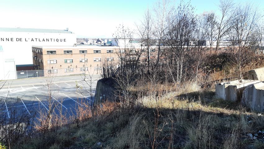
a parking lot for the HMC Dockyard (Figure 16).
Figure 15: Photograph of the construction of the retaining wall, 1918.
(Source: Kwiatek, 2006)
1967
Figure 16: Map of the CGR right-of-way and tracks, 1967.
(Source: Goad, C.E., 1967. Sheet 88, NSARM)Page 28
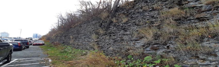
Physical Appearance
Site observation took place on three dates, September 28, 2019, November 6, 2019, and
December 1, 2019. Three sections of the retaining wall system were looked at. Photos
could not be obtained of the North Street to Niobe Gate Bridge wall section due to
security restrictions at the HMC Dockyard.
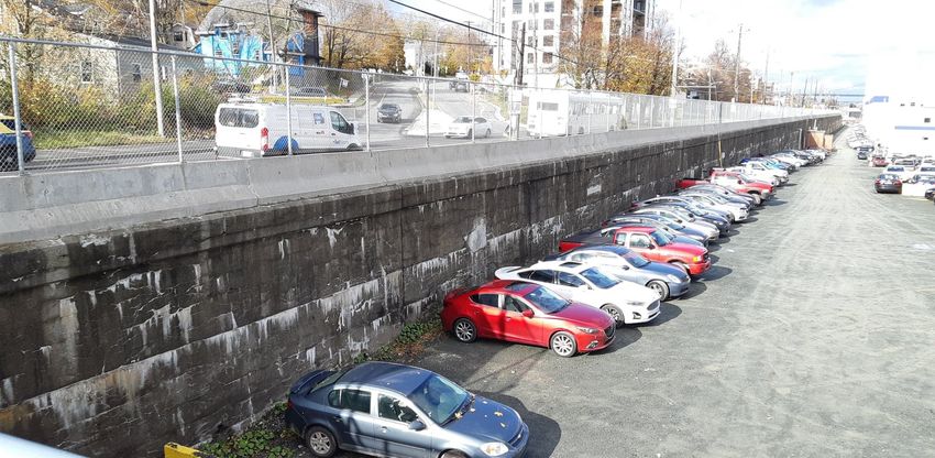
A) Cornwallis Street and Valour Way to North Street (1909)
Figure 17: Photograph of the retaining wall along the HMC Dockyard parking lot.
(Source: Maenza, 2019)
Figure 18: Photograph of the North Street ICR Station, 1902.
(Source: Maenza, 2019)
For much of this retaining wall section, the concrete wall indicated on the old fire
insurance map (Figure 10) is not apparent. Instead, the fill of crushed rock and rip-rap
that was located behind the concrete wall has been exposed and it extends for much of
the section (Figure 18). Near the footing of the Angus L. Macdonald Bridge, the concrete
wall section indicated on the maps appears (Figure 18).
The concrete wall shows signs of heavy wear with multiple long cracks, chips,
and discolouration. Efflorescence (a salt residue) appears as a chalkish-white colour
due to moisture from rain reacting with the concrete. Traces of rust appear from the
ironstone rip-rap behind the wall. Seasonally, the wall supports bulrushes and marsh-
like conditions at its base (Narratives in Space+Time Society, 2016).Page 29
B) North Street to Niobe Gate Bridge (1874-1877)
Figure 19: Photograph of the old masonry and new concrete retaining walls.
(Source: Alva Construction Ltd, n.d.)
Construction of the new retaining wall in front of the old masonry wall from the
1870s (Figure 19). Rock bolts and pre-cut concrete blocks are visible. Where the current
sidewalk barrier lies, a concrete cap was fastened and reinforced to the old masonry wall.
C) Niobe Gate Bridge to the Irving Assembly Hall (1918)
Figure : Photograph of the concrete retaining wall along the Irving Shipyards.
(Source: Maenza, 2019)
The concrete wall shows signs of heavy wear with multiple long cracks, chips,
and discolouration. Efflorescence (a salt residue) appears as a chalkish-white colour due
to moisture from rain reacting with the concrete (Figure 20). Traces of rust appear from
the ironstone rip-rap behind the wall. Unlike the 1909 wall near Valour Way, the retaining
wall on Barrington St is positioned much more vertically without a sloping angle.Page 30 Part 3: Chronological Timeline
Page 31

Before 1854
      For 100 years after its founding in 1749, Halifax was predominantly focused
on the military and it was spatially isolated from other Nova Scotian communities
and from the rest of Canada (Hodgins, 1992, p. 16). The city’s greatest commercial,
industrial, and military interests were met through the sea instead of through land
connections, and so, growth took place along the waterfront (Hodgins, 1992, p. 16).
       The establishment and expansion of the HMC Dockyard and barracks in 1759
(then known as the Royal Naval Dockyard) helped facilitate an increase in population
and industrial growth as working-class people and immigrants moved into the area
(Hodgins, 1992, p. 17). Moving goods, people, and armaments to and from downtown
Halifax and the Dockyard required transportation corridors which included the
construction of Campbell Road in 1838 and the construction of the Nova Scotia Railway
connecting Windsor and Pictou to Richmond via Truro (Erickson, 1986, p. 42).

1854-1877: The Railway Enters Richmond
        At the time of Confederation in 1867, Halifax was the fourth most economically-
important city in the Dominion of Canada and the economic centre of the Maritimes
(Blakeney, 1949, p. 13). It had flourished during the American Civil War as a neutral
port and remained a strategic asset of the British Empire. The harbour, with its
wharves crowded with shipping, made it hard to believe that the golden age of sail
would come to a close. For Halifax had prospered on the sea, the changing demands
of an industrializing nation meant that the new railway would be the city’s golden
ticket to a thriving future (Blakeney, 1949, p. 13).

Figure 21: Nova Scotia Railways locomotive, 1854-1867.
(Source: Library & Archives Canada, n.d. Copy negative C-002607)
This undated photograph shows Locomotive No. 6, Pictou, on the Nova Scotia Railway between
1854 and 1867. The Nova Scotia Railway was the first railway link across the province.
Page 32
Richmond Station
The privately-owned Nova Scotia Railway entered the Halifax Peninsula and
terminated at a freight depot at the foot of Barrington and Duffus Streets in 1854
(Figure 21 & 22). This would be later known as Richmond Station. It was selected as
a deep-water terminus for the loading and shipment of heavy freight, but wooden
structures and sheds signalled its temporary use. According to an 1875 report from
Halifax City Council, Richmond was never regarded as a suitable or entirely desirable
place for a passenger and freight station as its distant location was a cause for great
inconvenience, expense, and delay. By the 1870s, the station could not meet the
increasing demands and intensity of the military and industrial commerce in the city
(Joint Committee of the City Council and Citizens, 1875, p. 4).
Figure 22: Photograph of Richmond Station, 1860.
(Source: Richmond Station, 1860, Tom Connors 1987-218 no. 713 / negative no. N-388,
NSARM)
The Railway Extension from Richmond Station to North Street
By 1855, the Nova Scotia government had already decided on the matter of a
railway extension into downtown Halifax. It was not until Confederation in 1867 that
the Nova Scotia Railway was turned over to the Dominion Government as part of plans
for the Intercolonial Railway linking Halifax to Montreal. The Halifax City Council
also expressed a desire to advance the idea of a station in the heart of the city. It would
have required the removal of a guard house and several powder magazines from
HMC Dockyard-owned land. The Railway Commissioners had received permission
from the War Department and the Admiralty of the Imperial British Government to
carry the railway through the HMC Dockyard Naval Hospital and Magazine grounds.
Conditions were appended in the granting of the right-of-way, including that any
costs incurred in the demolition and reconstruction of assets were borne by the Nova
Scotia government (Joint Committee of City Council and Citizens, 1875, pp. Appendix
A; III-IV).
Ultimately, the provincial government’s ambitions in extending railways to the
west and east of Halifax meant that capital resources were heavily exhausted (Joint
Committee of the City Council and Citizens, 1875, pp. 4-5). In 1873, the proposal
was revised to separate freight from passenger traffic. The passenger station would
be located at the corner of North Street and Barrington Street, adjoining the HMC
Dockyard property, and the freight would be handled by a dedicated spur line and
terminal further south.Page 33
In 1875, City Council noted that the railway was planned at a low elevation
to the water level to improve the passage of passenger and freight. According to the
attached City Engineer’s report, the triangle-shaped portion of land which continued
to North Street (Figure 23) (popularly known as the “Jib”) was constructed by open
cut, allowing for a nearly level grade surface (Joint Committee of the City Council
and Citizens, 1875, p. Appendix C-IX).
(Source: Ruger, A., 1879. Library
of Congress. No. G3424.H2A3
1879 .R8)
Location of the North Street
Station in the “Jib” formed by the
intersection of Upper Water Street
with Barrington Street
Figure 23: Birds’-eye view map, 1879.
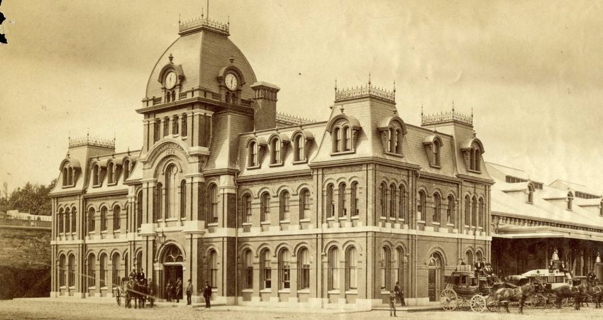
North Street Station
The North Street Station (also known as the Intercolonial Railway Station),
was one of the most imposing buildings in Halifax and one of the finest railway
stations in Canada (Figure 11 & 24). It was situated at the foot of North Street next to
Barrington Street. It was two stories tall and made from pressed brick and granite.
Designed by a local architect, Henry Peters, its beauty was often obscured by its
cramped position. Haligonians rejoiced at having a station closer to the downtown
core and lauded its modern amenities in comparison to the then outdated Richmond
station which in 1872 was deemed as “not fit for a cow stable or a wood shed” in an
article by the Acadian Recorder newspaper (Blakeney, 1949, pp. 88-89).
The grading of the land and the masonry work on the heavy ironstone retaining
wall from Richmond to North Street was completed by the contractor, Samuel McKean
from 1874 to 1877. It came at a cost of $178,302 (Sessional Papers of the Dominion of
Canada, 1878, p. 129). The retaining wall and open cut facilitated the construction of
the railway deeper into Halifax. The station was opened to the public in 1877.
Source: Canadian Science &
Technology Museum, 1912.
No. STR04089a
Rare interior photograph of the
North Street Station in 1912. The
Flying Bluenose was a luxury
express train servicing Halifax to
Yarmouth.
Figure 24: Photograph of station interior, 1912.Page 34
1878-1900: Industry in Richmond
Industrialization
By the late 1870s, the rapid
industrialization of Halifax was brought on
by new federal government attitudes in a
program known as the National Policy which
sought to connect the west and east coasts
by railroad and the promotion of Canadian
industries (Erickson, 1986, p. 42; Settle, 1994,
p. 3).
Erickson and Acheson both mention
that it was a protectionist measure in which
the Federal government placed tariffs on
imported goods in 1879 onwards which
boded extremely well for Richmond. In fact,
between 1881 and 1891, Nova Scotia had the
highest industrial growth rate (66%) of all
provinces. Major factories such as the Acadia
Sugar Refinery, Nova Scotia Cotton Company,
and Halifax Graving Dock were located along
the Intercolonial Railway tracks where the
retaining wall stood. The assumption was
that Nova Scotia could become the industrial Figure 25: Photograph of the
powerhouse of Canada as it contained the refinery, 1880.
largest port, viable coal and iron deposits, (Source: Notman Studio, 1880.
controlled the flow of fuel to Montreal and Nova Scotia Archives, no.
other provinces, and it was a gateway for 47660)
people and goods from the nation to the
world and vice versa (Acheson, 1972, p. 6; p. Photograph of the Nova Scotia
xiii; Settle, 1994, p. 7). (Acadia) Sugar Refinery, c. 1880.
Richmond was at the forefront of economic growth on the Halifax Peninsula
as it had major roads, railways, and goverment property in place. Located adajacent
to the retaining wall and the railway tracks, the most highly-touted industries were
the Acadia Sugar Refinery and the Nova Scotia Cotton Company founded in the
early 1880s. The refinery complex was the tallest building east of Montreal boasting
an impressive ten stories (Figure 25) (Erickson, 1986, p. 47). More than just the
refinement of raw materials, value-added goods were produced in Richmond as
well. The Nova Scotia Car Works produced railway passenger cars, the Hillis and
Sons foundry produced stoves and furnaces. There were factories that produced
coffee, beer, pianos, glassware, cigars, and shoes; something almost astounding in a
post-industrial Halifax (Erickson, 1986, p. 49).Page 35
The industrial surge of the late 19th century had brought extreme wealth to
Richmond. By 1900, this part of the peninsula had more than half of Halifax’s assessed
property valuation. Unfortunately, the profits did not last very long. The economic
centres of capital and population shifted west towards Quebec and Ontario. Towards
the 1900s, factories in Richmond were consolidated by Upper Canadian businessmen
(Erickson, 1986, pp. 49-50).
The combination of Victorian-era steam locomotives, smokestacks, loud noise,
and heavy industrial output branded Richmond as a working-class suburb. It soon was
avoided by middle-class homeowners and was not sufficiently given provision of city
services compared to the South End of the city (Erickson, 1986, pp. 50).Page 36
1917: The Halifax Explosion
At 9:06 a.m. on December 6th,
1917, Halifax changed forever. The Halifax
Explosion of 1917 devastated the suburb of
Richmond (Figure 26). The French munitions
ship Mont Blanc was enroute to join a trans-
Atlantic convoy. It carried 35 tons of benzole,
2,300 tons of picric acid, and 200 tons of TNT.
The ship collided with the Norwegian relief
ship Imo and was set on fire as it drifted
towards Pier 6. Over 2,500 tons of volatile
materials exploded giving off over 9,000 F
in heat. The resulting shockwave ripped
through Halifax at 21,436 kilometres per
hour. It was felt as far as Charlottetown and
Boston (Macdonald, 2005, pp. 62-63).
The explosion obliterated over six
square kilometres of the city, killing 2000
people, leaving over 9000 people with
injuries, and a further 10000 homeless.
The massive explosion from the cargo ship Figure 26: Photograph of cloud from
Mont-Blanc set off a tsunami which rose Eastern Passage, 1917.
between 15 to 8 metres above sea level
(Source: Library and Archives Canada,
(Macdonald, 2005, p. 66; Ruffman, et al,
1917. No. PA-166585/MIKAN 3531262)
1994, p. 337). Sections of the retaining wall
had received major damage. Richmond
Station was obliterated. The North Street
Station had its roof destroyed, and railway
infrastructure was strewn about. Forever
altered, Richmond needed a haste rebuilding
(Figure 27) (Smith, 1992).
Figure 27: Photograph of
Richmond in ruins, 1917.
(Source: MacLaughlan, W.G.,
Nova Scotia Archives, 1917.
No. 1988-34 no. 14 / negative:
N-137)
Looking north toward Pier 8
from Hillis foundry after great
explosion, Halifax, Dec. 6, 1917.Page 37
1918: Aftermath and Rebuilding
The Halifax Relief Commission was created in 1918 by the federal and provincial
governments to coordinate relief and reconstruction efforts (Erickson, 1986, p. 58). Part
of the actions undertaken by the Halifax Relief Commission included the rebuilding
of Richmond. Thomas Adams, an urban planner, was given a clean slate to layout his
vision, including parts of the Richmond bluff and other undeveloped areas (Ruffman,
et al, 1994, p. 410). He left the industrial areas below Barrington Street as unplanned,
providing no specifications regarding land-use and lot size. By 1918, Halifax Shipyards
Ltd. consolidated those properties. The lands of the Halifax Graving Dock, and
ruined Acadia Sugar Refinery all became company property as the railway facilities
themselves moved to the South End (Figure 28) (Ruffman, et al, 1994, pp. 414, 419;
Settle, 1994, p. 38).
Figure 28: Expropriation plan of the Acadia Sugar Refinery, 1917.
(Source: NS Registry of Deeds, 1917. Expropriation Plan #414)
This plan shows the expropriation of multiple parcels including that of the Acadia Sugar Refinery
to the Dominion Government. These were to be consolidated and sold to Halifax Shipyards Ltd.Page 38
The Halifax Relief Commission appraised the damages caused by the explosion
and tidal wave to over $25,000,000. Major losses occurred for the Canadian Government
Railways and the Naval Service Department of Canada. Damage to property belonging
to the Canadian Government Railways amounted to $1,225,000 of which $155,000 was
expensed on clearing debris and repairs. North Street Station was destroyed and the
main tracks were covered with debris (The Canadian Engineer, 1918, p. 558).
Cavicchi and Pegano
The railroad construction firm was contracted by the Halifax Relief Commission
to assist in reconstruction efforts following the Halifax Explosion. Originally operating
out of Montreal, Quebec, the company was founded by P. Pagano and Vincent J.
Cavicchi (Figure 29). The firm employed 1,250 foreign-born labourers and brought
400 of them to work in camps on Longard Road informally known as Cavicchiville
(Morton, 1989, p. 79).
The prime contractor in the rebuilding of the Halifax Shipyards, the firm won a
lucrative contract to clear debris in Richmond with a commission of 6.5%. It also began
the process of moving, grading, and ballasting 1.5 kilometres of railway tracks in July
1918. At that time, the firm became known as the Bedford Construction Company,
Ltd. (Morton, 1989, p. 83; Settle, 1994, p. 40).
Both Cavicchi and Pagano saw the construction of the shipyard as a
substantial economic and moral boost to the people of Halifax (Settle, 1994, pp. 39-
40). Approximately 2,000 new jobs would be created and spin-off industries would
emerge in supplying and supporting the shipyard. As the city’s biggest and most
modern employer, the shipyard would put Halifax and the province into the forefront
of economic development on the East Coast (Settle, 1994, pp. 39-40).
Figure 29: Photograph of an
excavator, 1908.
(Source: Gare de Riviere
Bleue, 2010)
Railway contractors Cavicchi
and Pegano excavating a
section of a Quebec railway,
1908.Page 39
Railroad Right-of-Way and the Retaining Wall
In expanding and filling the shoreline, the plan was to move all the railway tracks
along the right-of-way to allow for the construction of various shipyard workshops.
These workshops would face the railway to allow for the quick unloading of freight.
According to the Nova Scotia Registry of Deeds, there is a deed from Imperial
Government to Halifax Shipyards Ltd. which indicates the right-of-way granted to
the Canadian Government Railways through the shipyard property (Figure 30) (1919,
Book 498, Page 641).
As well, a massive reinforced concrete retaining wall was built along the railway
right-of-way, supporting the 1896 roadbed of Barrington Street (The Daily Gleaner,
1918, p. 8). The work undertaken by Cavicchi and Pagano required an estimated
270,000 cubic yards of earth and rock to be excavated and 20,000 cubic yards of concrete
to be poured. (Tomlin, 1918, p. 366). It stands as perhaps an unkempt and unnatural
division that separates the residential neighbourhood above Barrington Street with its
industrial counterpart below (Macdonald, 2005, p. 277).
Figure 30: Map of the relocation of the CGR tracks along Barrington Street, 1919.
(Source: NS Registry of Deeds, 1919, Book 498: Page 641)
Relocation of the Canadian Government Railway tracks adjacent to the retaining wall after
consolidation of the parcels of land by Halifax Shipyards Ltd.Page 40
After 1918: The Removal of Richmond
Richmond No More
The 1917 Halifax Explosion brought devastation and hardship to the city, and
in the long run it also brought a whole lot more. On that cold December morning,
the working-class neighbourhood had just awoke: parents stoked stoves and filled
furnaces, children dressed for school, milk deliveries were being made by horse-
and-carriage as the men made their daily rounds. The waterfront bustled with the
sounds and sights of ships, freight cars, bellowing factories, and noisy locomotives.
Noticing a flaming ship drifting towards the shore, faces of all kinds began to watch.
Presumably, with a clear view of the harbour, onlookers may have chosen a spot
along the hand-rails on Barrington Street to watch what unfolded. It is hard to believe
that in an instant, Richmond was obliterated off the face of the earth (Narratives in
Space+Time Society, 2016).
Before the explosion, Richmond was a thriving community with churches,
schools, factories, and many businesses. In fact, nearly half of all of the population
of Halifax lived in Richmond. After the explosion, the reconstruction process begun
by the Halifax Relief Commission through the powers set out in the 1915 Nova Scotia
Town Planning Act caused major changes in land-use and urban structure (Cahill,
2018, p. 66). Perhaps even Thomas Adams could not have envisaged the long-term
effects that the shipbuilding facilities and other spin-off industries would have on the
newly-christened North End. Future prosperity and population growth was idealized
as being hand-in-hand with serious industrial and residential development along the
waterfront and the slopes of Needham Hill during the 1920s.
Eventually, the visible traces of Richmond would fade as the new North End
was built. The absence of Richmond was felt through changes in names, the street
layout, buildings, the people, and in memories. Even the originally-named “Richmond
Heights” eventually became known as the Hydrostone District. Difficult economic
and social times during the 1920s and 1930s meant perhaps that Haligonians wanted
to push aside the tragedy of 1917 and move on with their lives. Understandably, it
took generations for survivors and the city to remember and recall the events of the
past. It was only in 1967 that the first city-sanctioned remembrance ceremony of the
Halifax Explosion took place. It took another eighteen years until the next service in
1985 and the opening of the Halifax Explosion Memorial Bell Tower on Needham Hill
(Elliott, 2019).Page 41
1945-1975: Urban Renewal on Barrington Street
Rationale for Redevelopment
Within the vicinity of the retaining walls, the urban form and function of the
land also changed. The heavy industrial and military uses along the waterfront and the
retaining wall system that barricaded it created an industrial landscape that became
a strong deterrent to any potential waterfront residential development. Barrington
Street was always a major corridor of movement and commerce but by the middle of
the 20th century, new municipal planning documents presented a number of ideas for
the redevelopment and growth of the city. The 1945 Master Plan for Halifax, the 1957
Redevelopment Study, and the 1965 Functional Planning Report for Harbour Drive
were the major documents. The dwellings in the North End were slated for clearance
(Stephenson, 1957, p. 17).
Barrington Street was selected as thoroughfare for the intensification of the
downtown core. An area of North Street was cleared as the approach ramps were built
for the Angus L. Macdonald Bridge (Stephenson, 1957, p. 26). By the 1960s and 1970s,
many Victorian-era homes, flats, and commercial establishments were demolished
on Barrington Street and the small side streets within the vicinity of the retaining
walls (Figure 31). Houses that overlooked both the railway and the naval facilities
were considered by city officials to have outgrown their usefulness and were seen as
unsanitary and overcrowded.
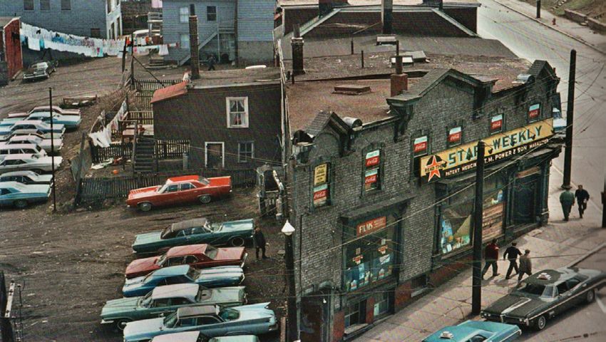
Figure 31: Painting of Elevator Court, Halifax.
(Source: Harris, L. 1921. Elevator Court, Halifax. Oil on canvas. Art Gallery
of Ontario, no. 2570)
Painting by Group of Seven member Lawren Harris of the tenement housing on
Elevator Court. The retaining wall lies beneath the fenced portion.Page 42
Harbour Drive
In 1965, the City of Halifax put forward
a plan to develop Harbour Drive, as the Nova
Scotia Planning Secretariat (NSPS) deemed it to
be a crucial piece of infrastructure that would
help circulate a projected 500,000 residents of
the Halifax region. It was a four-lane expressway
from the foot of Prince Street to the intersection
of Barrington Street and Devonshire Avenue, and
around the north end of the peninsula (Figure
32). Phase I involved the construction of the
Cogswell Interchange, a pretzel-like structure of
asphalt, pillars, and retaining walls. Phase II and
III involved a realignment of Harbour Drive to
the Mackay Bridge which included interchanges
at North Street and Devonshire Avenue (Figure
33). It did not proceed through the approval Figure 32: Cover of the Harbour
process at Council and became very unpopular Drive report, 1965.
with local citizens. By 1970, only the Cogswell
(Source: HRM Archives, 1965, no.
Interchange was built (Rutland, 2018, p. 194;
711.409716225 F)
Ziobrowski, 2015).
Figure 33: Plans of the proposed expressway, 1965. Retaining wall is highlighted in teal.
(Source: Ziobrowski, 2015)
Detailed plans by the DeLeuw, Cather & Company of Canada Ltd. in 1965 that showed the
path of the proposed expressway further cutting through the North End waterfront. This would
require the demolition of properties for the construction of elevated ramps and road segments.You can also read