River Lark Pollution Review and Action Plan - Prepared with support from: Bury Water ...
←
→
Page content transcription
If your browser does not render page correctly, please read the page content below
River Lark Pollution Review and Action Plan

Prepared with support from:
Version 1.0

Publication Date:       April 2021

Contributing Author and Editor
Dr Geoff Brighty      The Rivers Trust, Norfolk Rivers Trust and Environmental Sustainability
                      Associates Ltd.

Contributing Authors
Sam Hurst               Norfolk Rivers Trust
Ian Hawkins             Riverfly Partnership
Andrew Hinchley         River Lark Catchment Partnership (Chair)
Jim Stephens            River Lark Catchment Partnership
Christ Gerrard          Anglian Water
Sam Westwood            Anglian Water
Jessie Leach            The Rivers Trust
Becks Mundy             Natural England
Rob Bakewell            Environment Agency
Rob Clapham             Environment Agency
Steve Hopper            Environment Agency

Purpose of this Report
This document is for the River Lark Catchment Partnership for their use to identify and drive forward
a range of actions to mitigate pollution risks on the River Lark catchment, with relevant partners.

The report represents the work of a collaborative action group of organisations that came together
following a meeting in November 2020 with constituency Member of Parliament for Bury St Edmunds,
Jo Churchill. This report and action plan was drawn together by the editor and contributing authors
to represent the ecological health of the River Lark, to generate an understanding of the pressures
and state of the Lark, and identify possible solutions to reduce risks from, largely, pollution. A
companion report – The Lark Catchment Appraisal – produced by Sam Hurst, Norfolk Rivers Trust and
supported by a grant from CamEO Catchment Partnership, summarises the current ecological and
environmental state of the Lark catchment

Disclaimer
All views expressed in this report are given in good faith into the collaborative working environment
and supporting information is identified as far as possible.

Contact Details
Dr Geoff Brighty      (corresponding author)            geoff@envsustain.co.uk
Environmental Sustainability Associates Limited; Bankside 300, Peachman Way, Broadland Business
park, Norwich, NR70LB

Andrew Hinchley         Chair, RLCP                     ahinchley@yahoo.co.uk
RLCP email                                              admin@riverlark.org.uk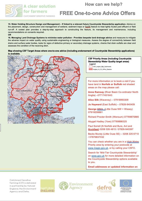
Contents

List of Figures

Foreword and Acknowledgements

1.      Introduction

2.      Summary of the State of the River Lark

2.1     Overview

2.2     Current State of the River Lark Catchment

2.3     Key Pressures and Locations
2.3.1   Physical Modifications
2.3.2   Low Flows
2.3.3   Point Source Discharges
2.3.4   Diffuse Pollution
2.3.5   Invasive Species
2.3.6   Key Impacts

3.      Review of current regulatory and non-regulatory plans, interventions and initiatives

3.1     Asset Management Programme 7 (AMP7) and the Water Industry National Environment
        Programme
3.1.1   Periodic / Price Review 2019 (PR19) and water company discharges
3.1.2   AMP investment on Water Abstraction - Sustainability changes
3.1.3   Unresolved Water Company-related Pressures in the Lark catchment
3.1.4   Improvements at Fornham likely to be addressed in AMP8 / WINEP
3.1.5   Non-regulatory measures delivering environmental sustainability benefits
3.1.6   Overview of key points that relate to AMP 7 and WINEP

3.2     Operational monitoring by the Environment Agency and response to pollution incidents
        2019/20

3.3     Rural Diffuse Pollution
3.3.1   Nature of the Lark catchment
3.3.2   Catchment Sensitive Farming update: plans and priorities
3.3.3   Norfolk Rivers Trust Water Sensitive Farming (WSF)

3.4     Flow variability

3.5     Wider regulatory issues/opportunities
3.5.1   Planning for development in and around Bury

3.6     Other relevant voluntary measures and projects
3.6.1   Abstraction Licensing
3.6.2   Water for Tomorrow - EU Interreg Project
3.6.3   Preventing Plastic Pollution
4.      Assessment of Risks and Gaps in Mitigating Pressures to the River Lark

4.1     Overview

4.2     Risks from Point Sources
4.2.1   Anglian Water WRCs – programmed work
4.2.2   Non-Water Company Point Sources
4.2.3   Gaps in interventions at point sources

4.3     Diffuse pollution
4.3.1   Natural England-led Catchment Sensitive Farming
4.3.2   Norfolk Rivers Trust Water Sensitive Farming (WSF)

4.4     Water Flow and Abstraction

4.5     Planning and growth

4.6     Issues not yet assessed for Risk Mitigation

5.      Potential Solutions and Recommendations to Mitigate Pressures

5.1     Overview

5.2     Fornham WRC

5.3     Other Point Sources

5.4     Rural Diffuse Pollution

5.5     Planning and Housing Growth

5.6     Working in Partnership
5.6.1   Integrated partnerships
5.6.2   Community Engagement and Citizen Science Partnerships

6.      Action Plan

Annex 1         Joint Planning Advice to Local Planning Authorities

Annex 2         FALMA (Farm and Land Management Advice) – Specialist Farm Visits

Annex 3         Water Sensitive Farming – Norfolk Rivers Trust
List of Figures

Figure 1.         Hydrological model of the Lark catchment

Figure 2.         Water Framework Directive Ecological Status 2019

Figure 3.         Left - Impassable barriers to fish movement. Right - Embanked channels upstream
                  of Bury St Edmunds

Figure 4.         Fornham Water Recycling Centre outfall

Figure 5.         Left -Lark catchment Land use. Right- Under-drained arable field sloping down to the
                  River Lark

Figure 6          The Upper Operational Catchment of the River Lark

Figure 7.         WINEP – Phosphate classification and evidence for eutrophication Pathway2Good
                  for the Lark

Figure 8.         Screenshot of the Optimiser tool – a jointly owned and operated tool for water
                  quality planning for England

Figure 9.         Map identifying each of the water recycling centres (WRCs) where phosphorus
                  removal will be delivered within AMP7

Figure 10.        Predicted Good Status for Phosphate for the end of the AMP 7 period (December
                  2024

Figure 11.        Proportion of effluent downstream of the Fornham WRC-ten year consistent
                  picture (Source: RLCP ‘citizen science’ group)

Figure 12.        Map of High and Medium Water Priority Areas for the River Lark Catchment

Figure 13.        Source, Pathway Receptor assessment for rural diffuse pollution

Figure 14.        SciMap tool used for land use and diffuse pollution risk mapping

Figure 15.        Example output from the SciMap tool showing surface erosion risk areas

Figure 16.        Seasonal flow variability on the River Lark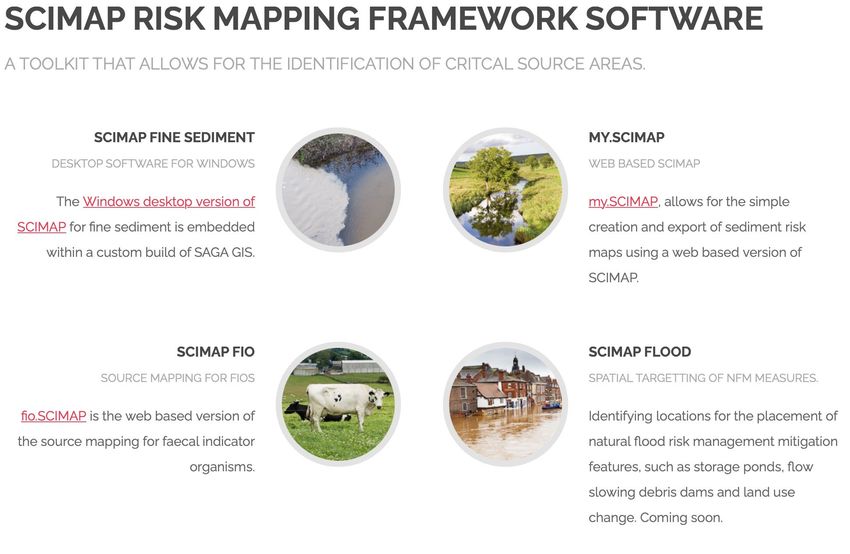
Foreword and Acknowledgements

As a Trustee of the Norfolk Rivers Trust since 2014, it’s been my aim to promote the collective action
of all stakeholders to value and protect our rivers, which, sadly, are seemingly facing an almost
intractable range of pressures. The Lark has presented itself in 2020 as a river under particular threat,
a combination of man-made impacts and climatic variations.

Yet it is one of the highest quality rivers from its geology, the rarest and most sensitive of natural
habitats – a chalk stream – one of 220 such rivers. The Lark and its feeder tributaries should be teeming
with life: gin-clear, cool calcareous water, with high oxygen levels, sustaining the larvae of mayfly and
dragonflies, brown trout, dace and minnow; beds of Ranunculus weed providing refuge for the aquatic
life, and oxygenating the water, as it flows over gravel beds and meandering gently down the valley.

Certainly, part of the Lark remains in a state resembling what you could expect a chalk stream to look
like. However, for the most part it has been degraded and has been ‘hanging on’ for a few years,
thanks to interventions by local volunteers and the River Lark Catchment Partnership.

It is anyone’s guess as to what has taken the Lark to this new ‘low’, but the recent three years of hot,
dry summer weather and sustained abstraction, coupled with the combination of point source and
wider catchment diffuse pollution from both town and land management is leading to a potentially
lethal, unsustainable combination of increasing pressures of pollution and water demand.

This has a moral and a legal imperative – this shouldn’t be happening. So, what can be done? how do
we build a resilient Lark so it can be enjoyed by everyone, and sustaining life from its source at
Whepstead and Bradfield Combust to its confluence at Littleport with the mighty River Great Ouse.

Taking forward projects where there are different interests, priorities and viewpoints is challenging. I
am therefore most grateful for the focus and spirit of collaborative working shown by all the group
members on the common goal to improve resilience of the Lark, so that we move away from this
critical moment and secure the status of the Lark as a resilient chalk stream in a changing climate.

On behalf of the Rivers Trust and as a member of the River Lark Catchment Partnership, I want to
acknowledge the contributions of the individuals who have provided the time, knowledge, evidence
and insights to help create this review:

Sam Hurst, Norfolk Rivers Trust          River Lark catchment appraisal
Ian Hawkins, Riverfly Partnership        ecological data
Becks Mundy, Natural England             Pollution sub-group lead; Catchment Sensitive Farming
Andrew Hinchley, RLCP                    Chair of RLCP
Jim Stephens, RLCP                       hydrological assessment
Jess Leach, Rivers Trust                 water resource assessments
Sam Westwood, Anglian Water              CamEO support, Anglian Water data
Chris Gerrard, Anglian Water             WINEP programme, technical and policy
Rob Bakewell, Environment Agency         water abstraction, WINEP programme
Rob Clapham, Environment Agency          water quality, planning, projects
Steve Hopper, Environment Agency         WINEP programme, water quality

Dr Geoff Brighty
Trustee – The Rivers Trust & Norfolk Rivers Trust
Environmental Sustainability Associates Ltd
1.       Introduction

The River Lark Catchment Partnership (RLCP) is working with a range of stakeholders to take stock of
the declining state of the main river, focusing on the Lark upstream of Bury St Edmunds, downstream
to Mildenhall.

Like all rivers in the UK, the Lark is facing a number of pressures to the so-called ‘quality’ of the water.
The chemical measurements of quality are a surrogate for the ability of that watercourse to sustain
the life expected of it, based on ecotoxicity data derived in controlled laboratory tests. Of course, the
complexity of water chemistry means that aquatic life is exposed to a range of chemical stressors
simultaneously, and which will differ daily, and within and between years due to weather and human
influences. Unravelling the specific stressor and how it is linked to the state of the river ecology is
challenging, and more so when the stressors are dynamic, and come from multiple sources across a
river catchment.

Building the picture to identify the critical stressors, and attribute to sources, and pathways and
ultimately the organisms within a river is possible, using the monitoring data from reliable sources
such as regulatory investigation programmes, discharge quality assessments, modelling and mapping
tools. Biological data, however, – freshwater invertebrate (and fish) communities, diversity and
abundance – integrates the true state of the water chemistry where habitat is not limiting their ability
to live, grow reproduce. To understand the state of a river, it’s the organisms that live within it that
hold the key.

Whilst undertaking chemical analysis reliably is a costly and highly technical activity, conducted largely
by scientists with high-tech analysers, it is notable that biological data can be gathered and analysed
by trained citizen scientists, and volunteers, who can provide essential evidence of change over time.
In this case, the trigger for this assessment has come from data from the Riverfly Partnership, which
has shown a clear decline in invertebrate communities, and with some evidence of the decline of fish
populations in reaches known previously to hold wild, natural spawning brown trout (Salmo trutta).
These findings were made following three hot summers and where rainfall was less than average,
creating ‘environmental drought and prolonged dry weather’ conditions (Environment Agency) which
extended through the period 2018-2021. The resulting low summer flows and high temperatures
would appear to be related to this ecological decline.

These findings were shared with relevant local partners in the autumn of 2021, at the time of the
completion of the latest round of water industry investment (Asset Management Planning round 7 –
AMP7) and the environmental improvement programme, Water Industry National Environment
Programme (WINEP).

Following a meeting with the Member of parliament for the Constituency of Bury St Edmunds, Jo
Churchill, the stakeholder group comprising the Environment Agency, Anglian Water, The Rivers Trust,
Norfolk Rivers Trust and the Riverfly Partnership committed to work together to develop an evidence
base, from which an action plan would be developed to reduce risks to the Lark catchment. This
stakeholder group was to be led by the River Lark Catchment Partnership, with support from:

     •   Anglian Water
     •   Environment Agency
     •   Natural England
     •   CamEO Catchment partnership
     •   Norfolk Rivers Trust
     •   The Riverfly Partnership, and
     •   The Rivers Trust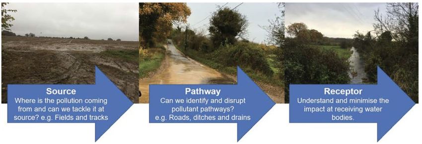
The purpose of this assessment is to:

•   Assess the current quality / state of the environment of the River Lark and its tributaries, against
    relevant benchmarks such as those set by Water Framework Directive and achieve Good Status
•   Identify the critical pressures on the environment, using best available evidence, and identify
    critical data gaps
•   Review the current regulatory measures and interventions being implemented to address the
    risks and pressures to the Lark catchment, and identify critical gaps in risk reduction measures
    necessary to achieve Good Status for the whole catchment.
•   Develop actions, forming an Action Plan, that can deliver effective responses to reduce risks, and
    address the underlying pressures
•   Inform relevant partners and stakeholders of the need for action, and enlist and gain
    commitment to deliver on those actions.

The approach to the study was to convene the group and to focus on two work areas – a catchment
appraisal, and an assessment of the regulatory and non-regulatory responses to manage risks. Each
workstream was conducted by independent working, with group discussions and presentations, taking
place via Zoom calls at intervals to review the information being gathered, and set out next steps.
Following these activities, a single workstream was formed to bring both elements together into a
single evidence base, to underpin the action plan.

Critical to the review and assessment process was to identify all relevant pressures and treat them
with balance. There has an initial focus on water quality and the main Anglian Water Water Recycling
Centre (WRC) discharges, due to the timing of this review and the recent WINEP settlement. However,
an equivalent amount of time has been devoted to diffuse rural and urban pollution to identify
similarly the pressures, sources and impacts.

The review process has led to the development of two main outputs – a Catchment Appraisal
(authored by Sam Hurst) and this report. The Catchment Appraisal will in effect be the basis for current
evidence and be a living document into which new data will be added over time, to address both data
gaps and maintain continuity with existing datasets.

This report on the River Lark Pollution Review and Action Plan is a snapshot of current and proposed
interventions, and aims to set out a range of actions that the RLCP and its partners can take forward
to reduce risks to the Lark, with the support of stakeholders. It is recommended that this report should
have a life of two to three years where the actions should be reassessed in line with progress,
environmental change, the development of the next water industry investment planning (PR24) and
following the implementation of the much-anticipated Environmental Land Management Scheme (see
recommendations).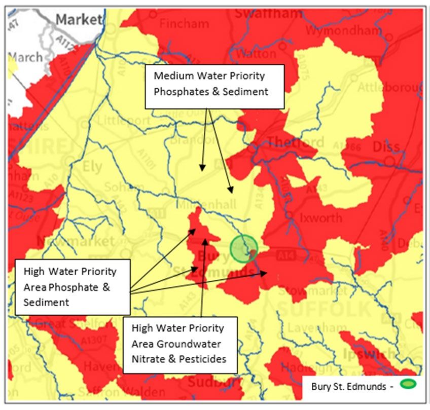
2.      Summary of the State of the River Lark Environment

This summary is taken from the Catchment Appraisal document, authored by Sam Hurst, Norfolk
Rivers Trust.

2.1     Overview

The river Lark flows for 57km from its headwaters in on the eastern edge of the Newmarket ridge in
Suffolk, to its confluence with the river Great Ouse near Littleport, in Cambridgeshire. The catchment
covers an area of south of Bury St. Edmunds, flowing north west to Mildenhall. Here the Cut-off
channel, a flood relief channel can divert water north to prevent flooding of Mildenhall and the low-
lying fenland downstream. Below Isleham the Lark enters the South Level fenland drainage area, a
pumped system, where water from the surrounding land has to be lifted into the embanked river.

The river Lark and its tributaries are vital to the economy of the West Suffolk area, and acts as an
environmental barometer reflecting the health of the wider landscape. The river Lark is one of only
~200 chalk rivers, a globally rare habitat, renowned for exceptional quality and consistent flow that
supports a unique aquatic ecosystem. The groundwater in the chalk aquifer supplies both the base
flow of the river, the entire areas public drinking water supply, as well as numerous boreholes
supplying industry and crop irrigation.

Figure 6.       Hydrological model of the Lark catchment

The Catchment Appraisal is primarily concerned with reaches of the Lark upstream of the cut-off
channel that has the potential to support chalk stream ecology.

The Lark and its tributaries above Mildenhall can be categorised 3 hydrological types;

1.      Ephemeral winterbournes (Lark above Bury St Edmunds, Linnet, upper Cavenham stream,
        Kennet-Lee Brook)
2.      Perennial chalk streams (Culford stream, lower Cavenham stream and Tuddenham Mill
        stream)
3.      Perennial main chalk river – baseflow from groundwater provides year-round flow.
        Considered to be from below Fornham lock/Sheepwash bridge (B1106) next to the remains of
        Fornham Park Lock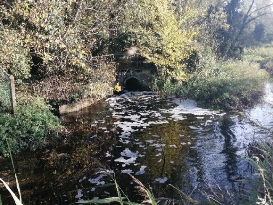
The Lark is a historically degraded river but retains the potential to support flourishing chalk river
ecology. The River Lark Catchment Partnership (RLCP) has been successful in delivering river habitat
restoration projects through the Catchment Based Approach (CaBA) however any ecological
improvement is limited by both poor water quality and the impact of abstraction on natural flow. The
environmental drought of 2018-19 had a significant impact on river flow and highlighted the fragility
of the Lark’s ecology in the face of mounting human and environmental pressures.

It is hoped that through this catchment appraisal the issues impacting the Lark can be better defined
and communicated to key stakeholders in order to develop an action plan that will deliver outcomes
to benefit the river Lark.

2.2 Current state of the River Lark Catchment

At present, none of the Lark’s surface waterbodies achieve good ecological status and none meet good
chemical status. Overall and ecological health of the river Lark catchment waterbodies have declined
slightly from 2015 to 2019, likely in part due to the environmental drought of 2018-19, and wider
trends of stalling – declining river health. Primary reasons for Lark waterbodies not meeting good
status are water quality – due to excess phosphate (7/12), invasive species – signal crayfish (present
in 12/12), heavily modified channel – limiting habitat and movement of fish (9/12) and low flows.

Figure 7.       Water Framework Directive Ecological Status 2019

Surface water quality: The Environment Agency (EA) classifies surface waters (rivers) and groundwater
health by sub-, according to the EU Water Framework Directive (WFD), classifying them from High to
Bad status. The WFD’s aim was to for all surface waters to achieve good ecological status by the end
of the 1st six-year RBMP cycle in 2015, although provision was made for a further two cycles up to
2027. The WFD has been adopted by UK legislation and goals have been incorporated into the 25-year
environment plan.

Groundwater quality: The chalk bedrock underlying the river Lark catchment is part of the same
geological formation running north east from the white cliffs of Hampshire to north west Norfolk. The
Lark groundwater unit therefore forms part of the wider Cam & Ely Ouse (CamEO) chalk aquifer
groundwater unit. The EA describes the groundwater flow as usually rapid and fracture flow dominant
making it especially vulnerable to pollution on the surface.
The groundwater aquifer is classified as of Poor status overall, Poor chemical status and Poor
quotative status. Anglian Water have identified high levels of Nitrate in the groundwater sources at a
number of their supply boreholes within the Lark catchment. This presents a risk to public drinking
water supplies and may also pose a longer-term risk to river water quality where connectivity to
groundwater remains high.

Hydrology – river flow: The source of flows has a significant impact on flows and water availability:
specifically, whether the streams are ephemeral or perennial. A study by the Environment Agency
(1999) identified that specifically for chalk streams, under natural conditions:

Depending upon the onset of autumn/winter rains, stream discharge tends to increase in December,
associated with a rainfall-induced rise in shallower sections of the aquifer, and continues to increase
until March or April. Through this time spring flow at the perennial head increases in strength, whilst
springs along the ephemeral ‘winterbourne’ section reactivate after lying dormant through the
summer months. Flows then decline steadily through the summer and autumn until the shallow aquifer
is again bolstered in the winter by percolating autumnal rainfall (ibid.).

This combination of perennial input from aquifer with ephemeral patterns throughout the main River
Lark and its tributaries seems a likely scenario for the Lark catchment. However, it is crucial to
understand the unnatural high levels of exploitation in the aquifer in the upstream catchment, causing
significant separation from river flow and potentially even indicating the streams are likely to no
longer be perennial (Environment Agency, 1992).

Furthermore, the discharges from the small sewage treatment works (STWs) upstream of Bury St
Edmunds do not discharge a sufficiently high amount to sustain a reliable baseflow, since the river has
been dry in Bury St Edmunds over the significant periods of prolonged drought. These two factors
indicate the streams are more likely to be mainly ephemeral (fed by rainwater). Environment Agency
confirms that the Cavenham stream and River Kennett-Lee Brook are ephemeral (Environment
Agency, 2014).

2.3     Key Pressures and Locations

The Catchment Appraisal draws attention to a range of pressures and locations. Broadly, the key
pressures are summarised as:

2.3.1 Physical Modifications
The Lark has been extensively modified for purposes of milling, navigation, flood defence and land
drainage, with only pockets of natural habitat remaining. The impact of which is an over wide,
straightened, embanked channel, lacking gravels and the floodplain connectivity that much of the
invertebrate and fish communities require. Redundant barriers and flood defence structures impound
flow, interfere with natural sediment transport and restrict the movement of migratory protected fish
species such as Brown trout and European eel. Extensive river and riparian habitat restoration would
have an enormous benefit not only to the ecology of the Lark but also flood protection, water quality
and amenity value.
Figure 8.       Left – Impassable barriers to fish movement. Right – Embanked channels upstream
                of Bury St Edmunds

2.3.2 Low Flows
Groundwater abstraction has been above sustainable levels since
the 1990’s, impacting on the duration of summer flow in the                Total Abstraction by sector in
                                                                                  Lark catchment
winterbourne streams of the upper catchment and possibly the
extent of the perennial Lark downstream of Bury St. Edmunds.
Abstraction for public drinking water supply is entirely sourced                    Indust
from the chalk groundwater aquifer and the sector has the largest                      ry
                                                                                     16%
influence on base river flows. Due to licence caps and forecast                 Agricu         Public
growth Anglian Water project that there will be a supply/demand                  lture         supply
                                                                                 27%            57%
deficit of 249M/L per day by 2045 (>10% annual average use)
without further action. Low river flows following periods of
reduced winter rainfall / aquifer recharge increase the already
sizeable influence of Water Recycling Centre (WRC) effluent
discharges and other sources of pollution.

2.3.3 Point Source discharges
Wastewater and surface water is returned to the environment either though outfalls into
watercourses or groundwater soakaways. The majority of abstracted water is discharged to the Lark
via Water Recycling Centres (Sewage works), the largest of which at Fornham can contribute >75% of
total river flow during dry periods. During periods of high rainfall capacity of sewers, pumping stations
and WRC’s can be exceeded resulting in storm sewage being discharged to watercourses without
treatment. Septic tanks and private sewage systems in rural areas also contribute to the catchment
pollution load as well as contamination of urban surface water drainage within Bury St Edmunds. Run
off from the A14 is also discharged to the Lark at 3 locations introducing vehicle pollutants such as
oils, combustion by products, brake dust, metals and tyre particles.
Lark (Abbey Gardens to Mildenhall) SAGIS
(Phosphate) Source Apportionment
2% 4%
Anglian Water WRCs
3% 10% Agriculture Livestock
6% Agriculture Arable
Urban
75%
Small domestic sewage
& spetic tanks
Other
Figure 9. Fornham Water Recycling Centre outfall
2.3.4 Diffuse Pollution
Land use in the Lark catchment is centred around arable crop production with the management of
agricultural land having a significant effect on the quality of river and groundwater. Field
underdrainage, reduction in grassland and a network of ditches have increased the connectivity of
fields to watercourses. Modern agricultural practices can also present a greater risk of greater risk of
soil, fertiliser and pesticide loss to the environment. Increasing trends for winter cropping, late
harvested root crops, maize (for bioenergy) and outdoor pigs can all leave bare, often compacted,
soils exposed to winter rainfall leads to surface run-off and leaching of nutrients.
Diffuse pollution risk areas are generally in the upper catchment above Bury St Edmunds, where the
clay soils lead to sediment being washed into the rivers
At present only 60% of agricultural land in the catchment is in any kind of environmental
stewardship scheme.
Figure 10. Left -Lark catchment Land use. Right- Under-drained arable field sloping down to
the River Lark
2.3.5 Invasive species
10-12 new non-native species become established each year in the UK, a rate that is likely to increase
due climate change. Invasive signal crayfish are understood to have entered the Lark in the early
1990’s and by the year 2000 had replaced the native white clawed crayfish in the through competition,
direct predation and disease. Signal crayfish have a significant impact on other species, predating fish
eggs, benthic invertebrates and small fry. Their burrowing behaviour increase bank erosion and bank
retreat by up to 253% and can input 25 tonnes of sediment per kilometre (Sanders, 2021).The other current invasive species impacting the Lark is Himalayan Balsam, a shallow rooting annual
plant that colonises riverbanks, dying back in winter to leaving bare banks vulnerable to erosion. Other
non-native invasive species in East Anglia that present a threat to the Lark are floating pennywort
(present on Cam and Ouse) and the Demon shrimp (Dikerogammarus haemobaphes).
2.3.6 Key Impacts
Sewage-related impacts include phosphate – leading to so-called eutrophication of the river, and
which encourages the creation of ‘sewage fungus’ that smothers the riverbed.
Sediment (from field and drains/ suspended solids in effluents), covering the riverbed, and impacting
on invertebrates and the spawning habitat of fish. Sediment also binds phosphate and so enriches the
river with nutrients. Sediment also arises from burrowing Signal Crayfish.
Nutrient enrichment leads to summer algal blooms and fluctuations in oxygen concentrations. When
coupled with high summer temperatures and low flows, leads to very limiting conditions for fish and
invertebrates.
According to an (excellent) joint report by the Environment Agency and NFU 1 Review of phosphorus
pollution in Anglian River Basin District” (May 2012), phosphorus’ concentrations for the Lark to
achieve ‘Good Status’ as a chalk stream should be 0.12 mg/l:
Table 2.4 – as taken from Review of phosphorus pollution in Anglian River Basin District” (May 2012)
Low river flows have the greatest impact during the summer-autumn when rainfall is lowest and water
use by the public and agriculture is at its highest. Low summer flows on the Lark are the result of low
rainfall in preceding winters that reduce the contribution of groundwater to support base river flow.
Lack of water directly impacts the amount habitat available to the ecology with falling water levels but
also by quality of habitat by concentrating pollutants.
In-combination effects – the river ecology faces all such conditions at different times of the year.
Therefore, the state of the ecology should be emblematic of the current state of the environment, of
the Lark, integrating the effects of all the pressures.
1
https://assets.publishing.service.gov.uk/government/uploads/system/uploads/attachment_data/file/291507/scho0512buwf-e-e.pdf3. Review of current regulatory and non-regulatory plans, interventions and initiatives
3.1 Asset Management Programme 7 (AMP7) and the Water Industry National Environment
Programme
3.1.1 Periodic / Price Review 2019 (PR19) and water company discharges
Overview
Water and sewerage companies are private monopolies, and are subject to the scrutiny of the market
regulator OFWAT. OFWAT uses a range of mechanisms to challenge the companies to be efficient in
their operation, drive value for customers and generate affordable bills for the services provided. A 5-
yearly business planning cycle (quinquennial) is applied to the water companies to oversee investment
required for the companies to meet performance targets set by Government, and statutory
requirements including environmental protection and service delivery.
The Environment Agency sets out drivers for investment to meet environmental obligations, and these
in turn translate into cost-benefit tested measures that the companies develop and cost into their
business plan.
Based on the assessment of environmental data, the water companies identify schemes to meet those
obligations. This part of the overall business plan is termed the Water Industry National Environment
Programme (WINEP). One of the implications for the PR process, and the resultant water company
business plan, is that is uses the most recent environmental data available at that time. For the plan
delivered to be implemented in 2020, the latest environmental data sets were from 2017.
Water company business planning begins well ahead of the determination date for a Periodic Review.
For example, the PR for 2025 Business Plan will begin early in 2021, with a draft business plan to be
delivered in 2023, ahead of the expected OFWAT determination making by the end of 2024. The
current Business Plan produced through PR19 has had an extra year of review due to the appeal by
Anglian Water, and the assessment by the Competitions and Mergers Authority (CMA) in 2020.
Figure 6. The Upper Operational Catchment of the River LarkAMP and WINEP Planning
This is a prescribed process, with two main criteria to meet Water Framework Directive (WFD)
obligations. The first is an absolute requirement that there must be no deterioration to the quality of
the water body, and secondly, to enable achievement of Good Ecological Status. In order to get to
Good Status, noting this is not an absolute obligation unlike not allowing deterioration, a range of
measures can be proposed that are possible but these need to be technically feasible, and cost
beneficial – i.e., the balance of cost and benefits needs to be positive. Measures apply to individual
elements under the WFD classification – we need to get to Good Status for ALL elements for the
classification.
In addition, there are AMP Planning rules, which requires the environmental problem to be clearly
described, and a clear link to the water company asset(s). This ensures that there is clear evidence to
support the investment, and that the scheme is necessary and will deliver a clear environmental
outcome. There is also a rule – the polluter pays principle – that states that individual organisations
should address their share of the overall problem. This is clearly a challenge when assessing multiple
assets and impacts within a catchment
AMP7 – WFD Drivers
The drivers are:
1. No deterioration drivers:
• reverse a reported deterioration where a measure is showing signs of deterioration. If there is a
link between the deterioration and the water company asset, then a scheme / measures can be
proposed within the next business plan
• Prevent a predicted deterioration: where modelling, predicts the impact of a future change in the
catchment which can be addressed by investment at a water company asset. Examples include:
• New growth & development
• Take-up of ‘headroom’ within current permit
2. Pathway to Good
• For PtG projects for Phosphate measures, the suspected eutrophication must be causing an
ecological impact, and linked to a water company asset, for a measure to be developed. Schemes
cannot be proposed that would remove another sector’s impact on that failure. In addition,
schemes must be technically achievable, and following extensive research in AMP6 period,
schemes that require a permit condition less than 0.25mg/l phosphate as a permit limit are not
considered as Technically Achievable. All these schemes also need to be cost-beneficial.
There is also the opportunity to ask water companies to take forward investigations where there
is some evidence of an impact linked to a water company asset, yet there is insufficient evidence
to secure investment. Whilst the WINEP does identify water company assets that contribute to
pressures within a catchment, the Environment Agency was clear to stress that the WINEP is
developed in the context of river basin planning, at a catchment-wide scale.Figure 7. WINEP – Phosphate classification and evidence for eutrophication Pathway2Good for the
Lark
Within the Lark operational catchment, the Environment Agency identifies where there is evidence of
eutrophication – this is identified in the purple shading – where the Environment Agency can ask the
water company to make improvements. The purple lines overlaying the rivers indicate the WFD
phosphate status for the river; the phosphate status for the individual Environment Agency
monitoring points where WFD status is assessed – the yellow/orange/blue points. The pie charts
below represent the output from the SAGIS water quality model used for source apportionment
assessment for phosphate, with the WAC as the Water company contribution. For the River Lark
catchment as a whole, at almost every Environment Agency sampling point, Anglian Water discharges
form a very large proportion of the phosphate load to the river.
The assessment overall starts at the upper reaches of the catchment and assesses the impact Anglian
Water discharges to the levels of phosphate within the catchment. Using the SAGIS modelling, the
Environment Agency uses an ‘optimiser’ tool to assess different options for the different discharges
within the catchment. An example of the optimiser tool is shown in Figure 8. It enables the
Environment Agency to assess what a permit limit would be for a discharge in order to achieve good
status in the water course downstream. Across a catchment, it allows an assessment of all the
discharges upstream of that discharge point and their contribution to the phosphate load, and
therefore what permit conditions, and therefore how much phosphate was needed to be removed,
would be needed for the downstream discharge and in combination with discharge limits for the sites
upstream, so that the downstream quality meets Good status for phosphate. Noting that permit
conditions cannot be set more stringently than 0.25 mg/l, the optimiser helps evaluate what else can
be done to reduce the concentrations of phosphate, but how that can be achieved is then a matter
for the water company to decide.Figure 8. Screenshot of the Optimiser tool – a jointly owned and operated tool for water
quality planning for England
The Environment Agency has generated an assessment spreadsheet, which summarises the planning
for improvements. For each of the Anglian Water water recycling centres (WRCs), the overview
identifies the waterbody, what the fair share permit conditions need to be, an overview of the options
appraisal process – is the permit limit cost beneficial, whether the improvement is technically feasible,
and has the project been placed in the WINEP?
Figure 9. Map identifying each of the water recycling centres (WRCs) where phosphorus
removal will be delivered within AMP7There is an additional challenge of the misalignment between the WINEP timelines for investment (to
December 2024) as supported by customer revenues within AMP7, and the River Basin Planning
timeline to December 2027 which identifies work necessary to achieve Good Status, but will fall
outside of the current WINEP programme – and so will need to be addressed between 2025 and 2027.
In terms of outcomes, following AMP7, the map below identifies in the areas shaded as green those
water bodies that will lead to Good status following the improvements to wastewater treatment. This
should also include the water body Abbey Gardens to Fornham (not indicated as green on the actual
map).
Figure 10. Predicted Good Status for Phosphate for the end of the AMP 7 period (December
2024)
This improvement in phosphorus to Good status and indeed ammonia over the AMP7 and other
previous AMP programmes, through works improvements should also lead to consequential
improvements to the dissolved oxygen, macrophyte communities, invertebrates and fish
3.1.2 AMP investment on Water Abstraction – Sustainability changes
Anglian Water’s AMP7 WINEP commitment includes reductions to 14 abstractions within the River
Lark catchment. Across all sources, environmental deterioration will be prevented by ensuring that
abstraction licences are capped to historic levels. Further restriction will apply to Rushbrook and Bury
St Edmunds sources, which directly impact flows in the River Lark and Linnet, upstream of Bury St
Edmunds. During periods of restricted river flows (150l/s), abstraction from these sources will be
significantly restricted, and will cease if flows drop further to 90l/s. To enable this reduction in
abstraction, a new water supply is expected to be brought into Bury St Edmunds via Anglian Water’sstrategic pipeline (to be delivered by 2025), leaving more water available in the Lark catchment. The
Lark and Linnet parts of this scheme have in fact been under study for a considerable period under
the title ‘Bury St Edmunds Lark Compensation scheme)’
This commitment should result in an immediate enhancement of flows on the Lark, but additional
activities are planned to increase the resilience of these ecosystems to reduced flow rates. Five of the
Lark tributaries will be restored in AMP7, with two of these also receiving direct flow support from
adjacent groundwater sources. These activities will be delivered in collaboration with local
stakeholders to ensure that they complement existing improvement plans for the River Lark
catchment. WINEP licence reduction measures include those at:
Nowton (60%, 1,490,000m3/yr)
Bury St Edmunds (27%, 736,000m3/yr)
Rushbrooke (15%, 338,000m3/yr)
Moulton (64%, 1,328,000m3/yr)
Gazeley (39%, 395,000m3/y)
Risby (31%, 469,361m3/yr)
Barrow Heath (7%, 257,000m3/yr)
Isleham (17%, 282,000m3/yr)
Beck Row (57%, 2,246,000m3/yr)
Eriswell (1%, 29,000m3/yr)
This amounts to a total volume of 7,570,361m3 recovered, over 34% reduction in quantities from
public water supply abstraction licences in the Lark catchment. These measures will be in place by
2025. At two sites, some of the use of that reduced quantity is to augment flow through river support
of a proposed 1.6Mld in the River Linnet (also by 2025) and 1.54Mld in the River Kennett and Lee
brook (by 2027) (exact river support quantities to be confirmed).
Although Anglian Water cannot yet supply detailed data on increase in total water supplementing
current flows, the benefits of even modest increases will have a dramatic effect on the Lark down of
Fornham WRC where the hif proportion of effluent as compared with river water is shown in Figure
11.
Figure 11. Proportion of effluent downstream of the Fornham WRC-ten year consistent
picture (Source: RLCP ‘citizen science’ group)3.1.3 Unresolved Water Company-related Pressures in the Lark catchment
Following the PR19 assessment, however, there are three water recycling centres that remain to be
addressed, where investment has already been considered but has not been made. The reasons have
also been indicated and are likely under the current guidance and state of the environment, to remain
as that position until 2024. Only if the guidance changes, or there is a change to river status indicating
deterioration, would these schemes be revisited for investment in the next business plan period.
Unless that situation changes, there is a low likelihood that those reaches of the Lark would get to
Good status.
Fornham WRC: Permit to achieve Good status is not technically achievable (nor cost
beneficial); large discharge
Mildenhall WRC: Permit to achieve Good status is technically achievable, but not cost
beneficial; large discharge
Chedburgh WRC. Insufficient evidence of impact on Water body/sample point to justify
costly scheme
Once a phosphorus scheme is delivered, water companies are incentivised meet their permitted
standards as efficiently as possible through the Ofwat price determination process. Invariably
companies will run their works below permitted levels to provide a buffer for compliance but the main
operating costs for conventional phosphorous treatment (chemicals and sludge handling) go up when
phosphorous levels in effluent are driven down. Consequently, there is a clear disincentive for
companies to significantly outperform phosphorous limits set down in their permits.
The question of whether this means opportunities for environmental enhancement are being missed
is not clear cut. In some cases, the financial and carbon costs of outperformance might be very high
and/or the ecological benefits limited because the state change required in the waterbody can’t be
achieved. But it is not clear this would always be the case.
Fornham WRC is being operated well below its Environmental Permit limits for phosphate. For
example, during 2020, the average concentration of phosphate in the final effluent was 0.74mg/l,
against a permit level of 2mg/l. Anglian Water is seeking to keep in place high levels of treatment at
Fornham to keep phosphate levels as low as possible, although it has been acknowledged by the
RLCP that this over-performance by Anglian Water goes against the approach of the economic water
regulator OFWAT, which expects Anglian only to be compliant with its Environment Permit.
3.1.4 Improvements at Fornham likely to be addressed in AMP8/ WINEP
An upgrade to the storm tank at Fornham All Saints WRC is not included within the current business
plan for AMP 7. The final date for required delivery of the Fornham All Saints storm tank upgrade, as
calculated by the Environment Agency, is 2027. This investment would align with the current end of
the Water Framework Directive legislation. As such, this scheme will be included within PR24 planning,
for delivery within AMP 8 (2025-2030). Anglian Water have explored the possibility of re-ordering the
storm tank upgrade delivery programme and are currently assessing the options.
In order effectively to trade upgrade schemes into the current business plan, such as Fornham All
Saints, one scheme must be swapped out/replaced. The schemes must be of similar size, similar capital
cost and most importantly, have the same or similar net environmental impact. These requirements
mean the opportunities for manoeuvre within the storm tank programme available to Anglian Water
are limited within AMP7.
3.1.5 Non-regulatory measures delivering environmental sustainability benefits
Chalk streams are typically cooler than other rivers because of the influence of groundwater. A large
glasshouse facility is being established at Ingham, St Edmunds, which, once complete, will produce10% of the UK’s tomatoes (or as now for its first January 2021 crop planted, also focus on cucumbers)
on an area the size of 47 football fields. The facility will take waste heat from Anglian Water’s water
recycling centre in order to warm the glasshouses. This means that the temperature of water going
back into the Lark will be lower, which is beneficial for the chalk stream. The final effluent is currently
around 15°c and the heat transfer will reduce this by about 5-10°c, depending on weather conditions.
This is an innovative example of a sustainable solution to address temperature impacts in sensitive
chalk streams, and reduce the energy demand of commercial business working in partnership with
the water company.
3.1.6 Overview of key points that relate to AMP 7 and WINEP
• There is substantial investment planned under the AMP7 WINEP programme for the Lark, across
the whole catchment, from the period 2020-24.
• The WINEP programme is based on addressing the ‘fair share’ of the pressures attributable to
Anglian Water to the catchment.
• Improvements to water recycling centres are based on a range of assessments including whether
the discharge is leading to a deterioration in status, and if not whether they are leading to
eutrophication and actual impacts, and which the measures are technically feasible and cost
beneficial.
• Of the schemes that cannot be progressed, the critical water recycling centre at Fornham is not
cost beneficial or technically feasible to meet a permit condition of less than 0.25 mg/l
• The data that were used to develop the programme were from the classification performed by
the Environment Agency 2016 – and so AMP7 decisions do not include environmental monitoring
data from 2017 onwards
• There is (probably) limited opportunity to influence the AMP planned, especially now that
WINEP ‘amber’ schemes have been turned ‘green’. Noting this is a substantial capital
programme for Anglian Water to manage, although dialogue was encouraged to discuss
options such as ‘swapping in/out schemes’.
3.2 Operational monitoring by the Environment Agency and response to pollution incidents
2019/20
The Environment Agency uses a combination of water company Operator Self Monitoring (OSM) and
pollution reports (via general enquiries or telephone hotline) to quickly identify suspected pollution
events. They also undertake routine risk-based sampling to monitor water quality throughout the
catchment.
The last audit of Anglian Water’s Fornham WRC was undertaken in 2012, with no significant issues
identified. During this time Anglian Water has been operating under OSM guidelines and the EA has
received no reports of non-compliance via this route. The Environment Agency has received public
reports of ‘suspected’ pollution at various locations in the Lark catchment over the last 2 years, which
were followed up by further investigation.3.3 Rural Diffuse Pollution
3.3.1 Nature of the Lark catchment
The Lark catchment faces a range of hazards from the wider rural catchment, particularly the upland
catchment above Bury St Edmunds. Evidence from the Lark Catchment Appraisal has identified a
range of hazards which fall within the term ‘diffuse pollution’. These include:
• Sediment erosion from fields following heavy rain;
• Losses from agrochemicals – nutrients and pesticides,
• Animal manures from pigs and other livestock
• Damage to, and reduction in soil quality
A range of interventions are available to reduce these catchment risks, delivered through advisory
schemes, aiming to ensure farmers and land managers are:
• aware of the risks from their farming operations, relating to the land and soils and the
cropping/livestock regimes they operate
• understand the regulatory requirements to prevent impacts from farming, and
• put in measures to reduce risks, using grant support where available.
These interventions are available from a range of providers, but fundamentally the schemes for
support are taken up on a voluntary basis, with no ‘requirement’ for farmers to engage or adopt them.
That said, advice and guidance is critical to reduce those risks to the environment and as the basis for
the stewardship (Entry Level / Higher Level) and grants to put in pollution reduction measures.
Therefore, to reduce catchment risks from land management and farming activities, engagement with
and support from farmers and landowners, remains critical.
3.3.2 Catchment Sensitive Farming update: plans and priorities
Catchment Sensitive Farming (CSF) is a partnership between Defra, the Environment Agency and
Natural England working with farmers and organisations in priority areas across England to improve
the quality of surface and ground water, and air. The partnership provides local expert advice, training
and grant support to enable farmers to take voluntary action to improve the environment and their
farm business. https://www.gov.uk/guidance/catchment-sensitive-farming-reduce-agricultural-
water-pollution. Following engagement by Natural England, the CSF programme supports the direct
delivery of advice and guidance by third party partners.
The aim of CSF is to lead, convene and accredit, working with farmers to help them adapt and make a
step change in their environmental ambitions. NE aims to strengthen our work with farmers groups,
and will further develop the full accredited scheme for farm advisers.
CSF aims to achieve outcomes including:
● A Well managed nature recovery areas across land, water and sea delivering resilient ecosystems
rich in wildlife and character, enjoyed by people and widely benefitting society;
● People connected to the natural environment for their own and society’s wellbeing, enjoyment
and prosperity;
● Nature based solutions contributing fully to tackling the climate change challenge and wider
environmental hazards and threats;
● Improvements in natural capital underpinning sustainable economic growth, healthy food
systems and prospering communities, and;● Evidence and expertise is used by a broad range of partnerships, organisations and communities
to achieve nature recovery and enable effective regulation and accreditation.
CSF contributes to NE priorities for nature by targeting at the highest priority areas for water and air.
CSF aims to deliver real benefits to nature across a range of 25year plan priorities through working
with people and communities. Building partnerships for nature’s recovery, partnership is core to the
approach for CSF and it will develop this further through landscape-scale innovative programmes.
Since 2006, CSF has worked with nearly 20,000 farms and helped farmers take more than 70,000
positive actions to reduce pollution. 92% of the farmers CSF has worked with are satisfied with its
one-to-one advice and by working together; CSF and farmers have achieved reductions in agricultural
pollutants – nitrogen levels down by 4%, phosphorus levels down by 8%, and a 12.3% reduction in
sediment. This has demonstrated it is delivering reductions land-based pollution from agriculture, and
protecting soil quality.
The Norfolk and Suffolk team’s mission within Natural England is to create an environment where
nature thrives across the two counties. From the sandy Brecks in the west through the fens and
marshes of the Broads and out to our stunning East Anglian coastline, the NE team identifies
opportunities to recover nature. Working with farmers and landowners, CSF activities for the Lark,
Thet and Little Ouse Catchment across Breckland aim to address diffuse pollution issues, enhance
elements including soil, manure, fertiliser and pesticide management, farm infrastructure and
business sustainability through implementation of agri-environment schemes and air and water
capital grants. The CSF programme is considering the catchment risk factors including arable farming
of light sandy soils, priority sources including pig and poultry farms, intensive agricultural businesses
and expanding urbanised areas. Farm engagements currently are determined by priority areas
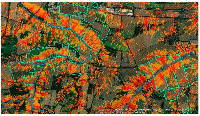
covering mainly phosphates and sediment and some smaller areas of nitrates (see Figure 13).
Figure 12. Map of High and Medium Water Priority Areas for the River Lark CatchmentWider CamEO (Cam & Ely Ouse) Catchment Objectives:
Reduce sources of nitrate and pesticide leaching to groundwater via promotion of:
Best practice measures relating to use of fertilisers, manures and pesticides
Improved management
Best practice for outdoor pig enterprises
Reduce sediment (and associated phosphate and pesticide) losses to surface waters via promotion of
good soil structure management and regular soil & manure testing.
Tools the NE team currently utilise in CSF – Phase 4:
1-1 Advice
1 to Many – Events.
FALMA (Farm and Land Management Advice) – Specialist farm visits – Refer to Annex 2
CaBA – Catchment Based Approach – https://catchmentbasedapproach.org/ as well as partnership
working across the catchment to improve diffuse pollution issues.
Work towards a steering group.
Countryside Stewardship – Mid Tier and Higher Tier schemes and capital grants –
https://www.gov.uk/government/collections/countryside-stewardship-get-paid-for-environmental-
land-management – Capital grants will be used to help farms improve current practices in the relevant
target area and all contact with the farms are currently recorded on CSF Reporter and a CS Tracking
Spreadsheet. Farms are also audited as required for evidence of adoption of recommended practices.
Engagements in the Catchment:
Nationally and locally, farms are engaged each year through expiring Stewardship schemes where CSF
provide advice through utilisation of Countryside Stewardship, one to one visits, events,
demonstrations and specialist visits, and by working in partnership with other local advisers and
agronomists, as well as Water Companies, NFU, CLA, Farming Advice service, EA and other advice
providers/speakers at meetings.
Across the Lark, Thet and Little Ouse, within the last 10 years, the NE advisors have delivered 200-300
unique engagements throughout Phase 3 and 4 of the CSF programme. Engagement types range from
events to 1-1 farm visits and specialist FALMA visits. NE are aiming for around an extra 20
engagements within the Lark specifically over the financial year 2021/2.
In the next phase of the CSF programme, advisory services are to be broadened to include advice on
air quality and flood mitigation, as well as on diffuse water pollution, with budgets to be confirmed
later in to 2021.
The priorities activities that will be progress are:
• Using the tools from Phase 4 as set out above.
• use Countryside Stewardship as one of the key tools through implementation of Mid-Tier and
Higher Tier schemes and capital grants – capital grants are now split up into 3 sections: Water
quality, air quality and boundaries, trees and orchards.
• The Clean Air Strategy (Air Quality)
• https://www.gov.uk/government/publications/clean-air-strategy-2019
• Natural Flood Management
• Water Resources – although not currently funded for this
• Nature Recovery Network Initiative – A major commitment in the government’s 25 Year
Environment Plan.
As CSF transitions from phase 4 to phase 5 over the next financial year a new action plan will be
developed for the Lark, Thet and Little Ouse through quarter 1 2021/22, this will include how CSF
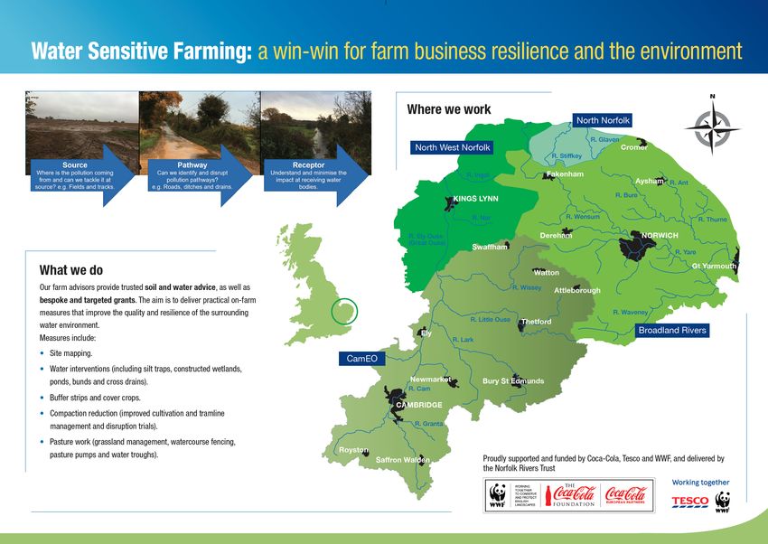
expands advice across our new primary objectives of air quality and flood management as well aswater quality. CSF delivery may include events such as, raising awareness of wider CSF initiatives as well as specific events such as soil health, air quality, livestock and natural flood management. 3.3.3 Norfolk Rivers Trust Water Sensitive Farming (WSF) Water Sensitive Farming (WSF) is an initiative that provides independent farm support and advice. The aim is to deliver practical on-farm measures that improve the quality and resilience of the surrounding water environment. Operating at a catchment scale, mainly in the Broadland Rivers and Cam and Ely Ouse (therefore, including the Lark) catchments, NRT farm advisors develop bespoke and flexible soil and water solutions that are tailored to individual needs. Based on the ‘source, pathway, receptor’ approach, on-farm improvements are then developed include silt traps, wetlands, buffer strips as well as advice on field risk, tillage, and cover crops. Figure 13. Source, Pathway Receptor assessment for rural diffuse pollution WSF has been funded by the Coca-Cola and WWF Freshwater Partnership since 2012, and is now also supported and funded by Tesco. Projects have been presented in Land Management Newsletters, created in partnership with the Wissey Water Quality Group. For more info, and to see the full list of grant options, view the WSF farmer leaflet, also shown in Annex 3. WSF has also been the key delivery mechanism for delivering water quality and quantity improvements in East Anglia, as part of the Courtauld 2025 Water Ambition. Risk and Opportunity Mapping – SciMap As a basis for planning where on-farm measures might be needed, the Trust uses the software package SciMap. This is used as a mapping guide to identify whether there is a risk that this pollution might enter watercourses via hydrological connectivity – field drains, streams and rivers. SCIMAP provides the framework to consider where in the landscape these pressures are coming from and hence where mitigation actions would be most effective. SCIMAP works by identifying where there is a significant source of the pressure, related to attributes such as land cover, topographic position and ground slope gradient, and the connectivity, which is the ease with which material can make it to the channel.
You can also read