ROGERS DATA CATALOGUE - www.rogersdata.at
←
→
Page content transcription
If your browser does not render page correctly, please read the page content below

ROGERS DATA
                                                CATALOGUE
                                                www.rogersdata.at
Scan the QR code and discover our assortment!

                                                        VFR CHARTS
                                                        PILOT ACCESSORIES
                                                        ICAO CHARTS         ACCESSORIES        NAVIGATION            RULES & REGS
                                                        Digital & Printed   Pilot- & Cockpit   NAV Compass,          Current VFR charts,
                                                        ICAO VFR Charts     Accessories        Protractor Triangle   Back-Up System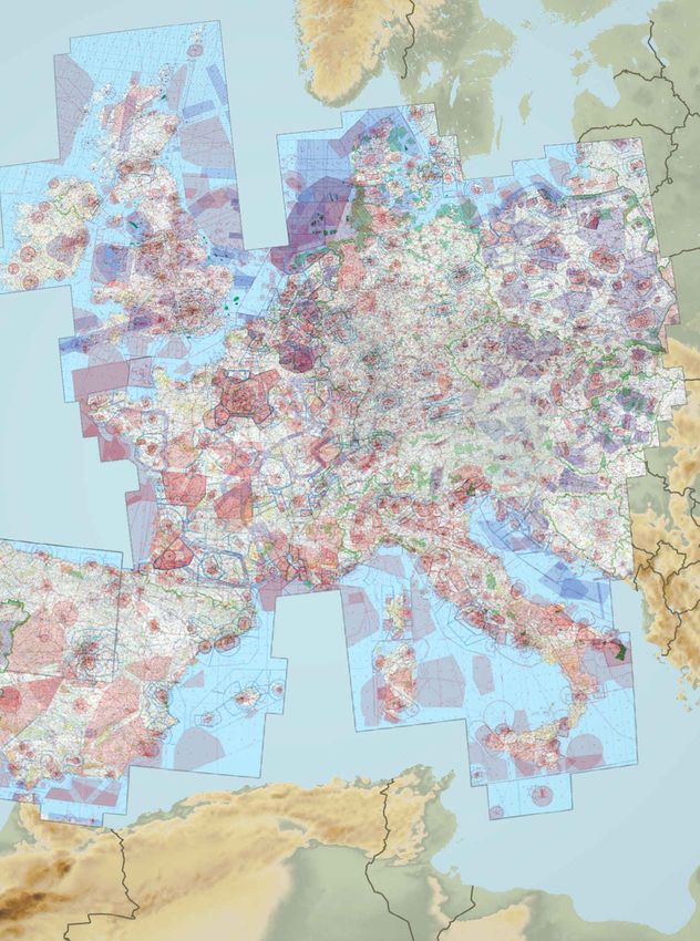
Dear Pilots,
Rogers Data provides VFR charts -
ICAO charts for almost every coun-
try in Europe. From North to South,
from East to West. Same look,
same feeling, same quality. Rogers            Precision and reliability!
                                              This is what ROGERS DATA stands for with
Data VFR aeronautical charts have
                                              its range of flight preparation products,
a very detailed representation of             charts and pilot accessories.
ATS airspace structures. We use a
high-quality topographic map with             Precision and reliability!
shading and relief. This creates a dy-        This is what ARISTO, as the inventor of the
namic 3D impression. They include             Geodreieck® stands for with its range for
                                              over 100 years.
TMZ transponder mandatory zones,
RMZ radio mandatory zones, air-               So what could be more obvious than to com-
ports, aerodromes and heliports with          bine these two competences! Within the fra-
additional information, compulsory            mework of a cooperation between ROGERS
reporting points, reporting points            DATA and ARISTO in the areas of product
on request, significant points (bor-          development, production and sales, which
                                              has been concluded since this year, several
der crossing), Radio Navigation Aids
                                              high-quality navigation aids for aviation and
with name, frequency and morse                seafaring have already been created. You are
code, obstacles or group of obstacles         welcome to convince yourself of their pro-
and aerial sporting and recreational          duct quality in the 2021 range.
activities, areas with sensitive fauna.
All Rogers Data VFR aeronautical
charts are based on the latest ae-
                                              www.kursdreieck.at
ronautical information from AIP (Ae-
ronautical Information Publication)
and their supplements of CAA CAA          vantage of the new and unique RD-         RDtech® pens and still allow those
(Civil Aviation Authority). They are      tech® technology is the fact that all     markings to be removed residue-free
based on the relevant regulations of      Rogers Data charts are almost im-         with our RDtech® spray or RD tech®
ICAO Annex 4 and EU-Regulations.          possible to tear, are designed to wi-     cleaning tissue. All this can be done
Rogers Data VFR charts are coated         thstand excessive use and can be          multiple times and the your VFR chart
using our unique RDtech® laminati-        folded many times. Rogers Data VFR        will still look like a brand-new chart.
on technology. This technology is not     charts have a special laminate with
what you have in mind. It is comple       a silk-mat finish that prevents reflec-
tely different from anything else that    tions from the sun. Our charts can be
you have seen before. The great ad-       written on using our permanent            Ing. Robert Gallmayer
                                                                                    CEO & Commercial Pilot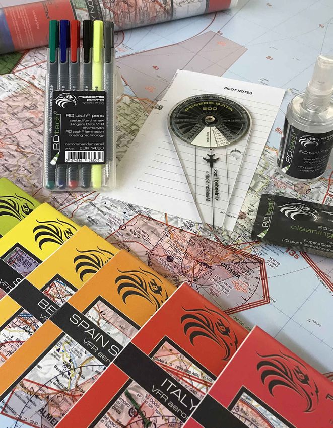
CONTENT
         VFR AERONAURICAL CHARTS
04       Europe Coverage | VFR Charts 1:500.000
06       Digital Charts NEW
18       Printed Charts NEW
30       Overview VFR Charts 500k vs. 200k

         RULES AND REGULATIONS
32       Current and suitable VFR charts
37       Interception procedures and signals on board

         VFR TRIP KIT
41       Austria VFR Trip Kit

         FLIGHT PLANNING
43       Navigation Compass
45       Leather or Nylon Cover for Compass NEW
48       Professional Protractor Triangle NEW
50       RDtech® (Pens, Spray, Cleaning Tissues)

         AVIATION DESIGN ACCESSORIES
53       XL Picnic Blanket
53       Sportbags / Backpack
55       Beach Towels
55       Keychains NEW
57       Aviation Design Posters NEW

         RESELLERS
58       Europe

     Scan the QR code and
discover our assortment!
                                www.rogersdata.at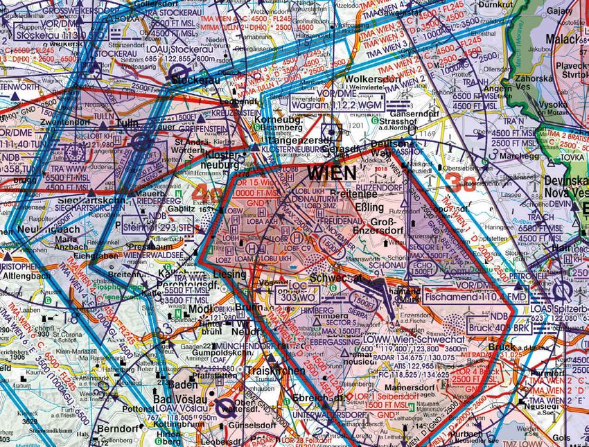
COVERAGE 1:500.000
www.rogersdata.at
Enjoy flying
with Rogers Data
VFR charts!
All Rogers Data VFR charts have the same design,
the same chart image and the same quality. The uni-
form and familiar layout of the maps allows you to
find your way easily. No matter in which country you
are flying. Rogers Data VFR charts comply with the
relevant provisions of ICAO Annex 4 „Aeronautical
Charts“, as well as the relevant EU regulations.

All our VFR charts 2021 will be available in digi-
tal version either as a single chart or as reasonably
priced bundles at our digital cooperation partners!
Find all Rogers Data`s digital cooperation partners
on pages 08-15.
DIGITAL VFR CHARTS FOR
APPLICATIONS OR AS
SOFTWARE FOR
NAVIGATION DEVICES
Rogers Data does not provide its own application or     be integrated as software into the navigation de-
navigation device. Instead we provide our digital VFR   vices. Rogers Data VFR charts in digital version either
charts to our cooperation partners for their applica-   be purchased as a single chart or as reasonably priced
tions and integrated navigation devices. The idea is    bundles. We offer bundles ranging in sizes from coun-
that customers are able to download all Rogers Data     tries, over regions up to a bundle that offers our com-
VFR charts directly from the different applications.    plete set of VFR charts. Depending on the size of the
And for integrated end-to-end solutions for platforms   bundle the discount varies, with the biggest discount
and ground assets, our Rogers Data VFR charts can       for the „Full Europa Bundle 500k“.

      FULL EUROPE
      COVERAGE 500k BUNDLE
      From 2021 onwards with:
      Norway, Sweden, Bulgaria,
      Kosovo, Montenegro, North Macedonia,
      Greece

06   VFR AERONAUTICAL CHARTS
SOUTH EAST EUROPE        COUNTRY
COVERAGE 500k BUNDLE     COVERAGE 500k BUNDLES
                         We offer different Country-Bundles, like the Great-Bri-
                         tain-Irleland-Bundle, the Sweden-Norway-Bundle,
                         the France-Corsica-Bundle, the Spain-Canarias-Por-
                         tugal-Madeira-Bundle and the Italy-Malta-Bundle.
                         For the scale 1:200.000 we offer the Austria-Slove-
                         nia-Bundle.

                         On the next following pages you will find all our di-
                         gital cooperations partners. They all offer our Ro-
                         gers Data VFR charts and/or bundles for download
                         directly from their different applications.

  CENTRAL EUROPE
  COVERAGE 500k BUNDLE

                                         VFR AERONAUTICAL CHARTS             07
Plan, File, & Fly with
                             Rogers Data + ForeFlight
Rogers Data and ForeFlight Mobile are the perfect pair for planning and flying in
Europe! Bundle your favorite charts with a ForeFlight subscription to access detailed
VFR information across Europe, along with EUROCONTROL-validated flight planning
and filing, weather visualization tools, hazard awareness features, and more!

The essential integrated flight app for VFR & IFR pilots is available
to download on the Apple App Store!

FOLLOW US
@ForeFlightEurope

DOWNLOAD TODAY
Available on the
Apple App Store

START YOUR FREE TRIAL
foreflight.com/europe

   08   VFR AERONAUTICAL CHARTS
SKY DEMON
                                                     Rogers Data provides the Austria Rogers Data
                                                     VFR Trip Kit via SkyDemon, which can be down-
                                                     loaded by the use of the App Store or Google Play.
                                                     It contains georeferenced, approach and aerodro-
                                                     me charts including military aerodromes as well as
                                                     all information you need to fly.
                                                     Rogers Data VFR Trip Kit can be installed in the
                                                     SkyDemon application itself via download. Please
                                                     open your Sky Demon app and download your Ro-
                                                     gers Data VFR Trip Kit there.

                                                     Note: This product is sold as a one year-long sub-
                                                     scription which is separate to your SkyDemon
                                                     subscription.

                                                     Web: www.skydemon.aero/store/rogersdata.aspx

ROCKETROUTE
Android and iOS, Google Play compatible

RocketRoute was developed for PC or Mac with
modern browsers. For tablet and smartphone
users, Rocket Route offers both dedicated apps
and a ‘lite’ mobile web app so you can manage your
flight plans on the go.
Download Rogers Data VFR charts and VFR Trip
Kits directly from the app via Google Play or App
Store. Please open your Rocket Route app and
download your Rogers Data VFR aeronautical
chart there.

E-Mail: support@rocketroute.com

            FULL EUROPE
            COVERAGE 500k BUNDLE

            SOUTH EAST EUROPE
            COVERAGE 500k BUNDLE

                                                              VFR AERONAUTICAL CHARTS            09
AIR NAVIGATION
Android and iOS compatible

Air Navigation Pro is an application for flight plan-
ning and a real-time navigation application for
iPhone, iPad and Android devices. A desktop ver-
sion for Mac OS X is also available.
All Rogers Data VFR aeronautical charts and VFR
Trip Kits are available for download directly from
the Air Navigation Pro app. Please open your Air
Navigation Pro app and download your Rogers
Data VFR charts there.

Web: services.airnavigation.aero
Support: support.airnavigation.aero

                                                        AIRBOX SYSTEMS
                                                        Android, iOS and Google Play compatibel

                                                        Airbox Systems is an application for flight planning
                                                        and navigation. Download Rogers Data VFR charts
                                                        and VFR Trip Kits directly from the Airbox Systems
                                                        app. Please open your Airbox Systems app and
                                                        download your Rogers Data VFR charts there.

                                                        Webshop: www.airboxsystems.com
                                                        E-Mail: info@airboxsystems.com
                                                        Phone: +44 1235 227 360

                                                                    FULL EUROPE
                                                                    COVERAGE 500k BUNDLE

                                                                    SOUTH EAST EUROPE
                                                                    COVERAGE 500k BUNDLE

  10    VFR AERONAUTICAL CHARTS
AIRMATE
iOS and Google Play compatible
Airmate is an application for flight planning and
navigation. Download Rogers Data VFR charts
and VFR Trip Kits directly from the Airmate app.
Please open your Airmate app and download your
Rogers Data VFR charts there.
Webshop: www.airmate.aero
E-Mail: airmate@airmate.aero
Phone: +352 26441835
FULL EUROPE
COVERAGE 500k BUNDLE
SOUTH EAST EUROPE
COVERAGE 500k BUNDLE
AVMAP
Navigation devices with integrable chart material
The view is individually configurable as usual and
offers charts view with vertical profile, HSI, EFIS,
NAV DATA and many more. Rogers Data VFR
charts and VFR Trip Kits can be integrated into the
navigation devices as software.
There is a contractual agreement with AvMap that
all available Rogers Data VFR aeronautical charts
can be made available to AvMap users. Customers
of AvMap can contact AvMap directly to obtain our
charts.
Web: www.aeroshop.eu
E-Mail: info@aeroshop.eu
Phone: +37052040970
VFR AERONAUTICAL CHARTS 11Easy to use software for our high brightness
multifunctional displays FlymapL (6,4”) /
FlymapXL (10,4”) , Apps for Android / Apple
and FlymapWIN.
Contact Flymap for your Rogers Data
VFR charts 500k.
Webshop: www.flymap.net
E-mail: info@flymap.net
Phone: +49 2154-8809711
FULL EUROPE
COVERAGE 500k BUNDLE
SOUTH EAST EUROPE
COVERAGE 500k BUNDLE
LX NAVIGATION
navigation devices with integrable map material
LX navigation systems are designed by perfor-
mance pilots and made for competition pilots and
clubs. Rogers Data VFR charts and VFR Trip Kits
can be integrated as software in the navigation de-
vices. On request we can provide our VFR charts
for navigation devices (LX Zeus) in digital form for
customers of LX Navigation.
Contact LXnavigation for your RD VFR charts.
Web: www.lxnavigation.com
E-Mail: info@lxnavigation.com
Sales Support: +386 (0)3 490 46 70
Contact LXnav Gliding for your RD VFR charts.
Web: www.gliding.lxnav.com
E-Mail: info@lxnav.com
Phone: +386 592 33 400
12 VFR AERONAUTICAL CHARTSEURO AVIONICS
Software for navigation devices
Euroavionics offers an integrated end-to-end solu-
tion for platforms and ground assets. Rogers Data
VFR charts and VFR Trip Kits can be integrated as
software in the navigation devices.
Licensing and conversion of Rogers Data charts:
To use Rogers Data VFR aeronautical charts, the
chart material must be licensed and the charts
must be converted for the respective system. The
conversion of the charts can either be done by Eu-
roavionics or by us for a fee. You have to provide
the systemtype (Euronav 3, 5 or 7) and the soft-
ware number.
FULL EUROPE
COVERAGE 500k BUNDLE
SOUTH EAST EUROPE
COVERAGE 500k BUNDLE
MOVING TERRAIN
navigation devices with integrable
map material
Moving Terrain is a manufacturer of multifun-
ctional displays. Austria Rogers Data VFR ae-
ronautical charts with a scale on 1:200.000 can
be integrated into the terminals as software.
The processing is carried out directly via Mo-
ving Terrain.
Please contact Moving Terrain for the Austria
Rogers Data VFR chart 200k.
E-Mail: sales@moving-terrain.de
Phone: +49 (8376) 92 14 0
VFR AERONAUTICAL CHARTS 13FLIGHT PLANNER
Software for Windows PC
The digital Rogers Data aeronautical charts can be
used for the software Flight Planner for flight plan-
ning, Moving Map for Windows PC, for Sky Map,
the Aviation Moving Map for PDA and PNA, as well
as for StrePla.
Rogers Data VFR charts for Flight Planner can be
ordered at our webshop: rogersdata.at/shop
SKY MAP
Android and iOS compatible
Sky Map is a moving map navigation software for
iPhone, iPad and Android devices or Windows
operating system. Sky Map shows the position
and flight direction provided by a GPS as well as a
planned route on a digitized aeronautical chart. In
addition there are many useful functions for flight
preparation and in-flight support.
Download Rogers Data VFR charts and VFR Trip
Kits directly from the Sky Map app. Please open
your Sky Map app and download your Rogers Data
VFR aeronautical chart there:
www.sky-map.de
FULL EUROPE
COVERAGE 500k BUNDLE
SOUTH EAST EUROPE
COVERAGE 500k BUNDLE
If you already have our current VFR charts for
Flight Planner, you can activate them on your
iPhone or iPad with your chart serial number!
14 VFR AERONAUTICAL CHARTSOzRUNWAYS
Android, iOS compatible and Google Play
Simply find OzRunways EFB on the Apple App
Store or RWY for Android by OzRunways on Goo-
gle Play and download it for a free one month trial!
At any time during or after your trial period, come
back to OzRunways` website and click
„My Account“ to purchase a subscription.
Web: www.ozrunways.com
As part of the cooperation between OzRunways
and Rogers Data, all Rogers Data VFR aeronauti-
cal charts and VFR Trip Kits are available to you.
Please open your OzRunways app and download
your Rogers Data VFR charts there.
FULL EUROPE
COVERAGE 500k BUNDLE
SOUTH EAST EUROPE
COVERAGE 500k BUNDLE
DYNON
Software for navigation devices
Dynon portable products, „all in one“ instruments
or skyview products are designed to have a clean
and intuitice pilot interface.
All Rogers Data VFR aeronautical charts and VFR
Trip Kits are available. The processing is carried out
directly via Dynon Avionics. Please contact them:
www.dynonavionics.com
FULL EUROPE
COVERAGE 500k BUNDLE
SOUTH EAST EUROPE
COVERAGE 500k BUNDLE
VFR AERONAUTICAL CHARTS 15BENEFITS OF ROGERS DATA VFR CHARTS - ICAO CHARTS
ACCORDING TO ICAO ANNEX 4; EU-REGS.
Name designations for significant points TRA - Temporary reserved airspace
Rogers Data VFR charts contain significant points Rogers Data VFR aeronautical charts contain airspa-
for visual flights. ces classified as airspace C and D, published in verti-
cal and lateral dimensions. When a TRA is activated
National parks und nature reserves this airspace changes temporary to class G.
Rogers Data VFR aeronautical charts contain nature
reserves and national parks with restrictions regar- Scan the QR code of your preferred language and
ding aviation. They provide a practical overview to watch the video of the explanation of Rogers Data
avoid violations of the relevant legal provisions. VFR charts.
Czechia
Aerial sporting and recreational activities
Rogers Data VFR aeronautical charts contain the
aerial sporting areas where increased traffic and RC
(radio controlled) model flying has to be expected.
VFR-Sectors
Rogers Data VFR aeronautical charts contain arrival- VIDEO VIDEO
DEUTSCH ENGLISH
and departure sectors.
GERIN
VERLEIHT
FARBKOMPETENZ
Echte Druckqualität seit 1871
www.gerin.co.at
58 |LE ARNING AT A HIGHER LE VEL
Professional
Training Material & Exam Preparation
UAS | UL | PPL | IR | CPL | ATPL
Our ECQB-PPL Question Database
is used by CAAs worldwide.
We use Rogers Data charts.
Desktop iOs App
www.aircademy.com
Rogers Data VFR charts are also used for the ECQB-PPL question database
of AIRCADEMY, which is used by the following aviation authorities (CAAs).
(Airacademy is in negotiations with others):
Germany: Austria
Berlin / Brandenburg Hungary
Bremen Parts of Belgium
Hamburg Malta
Mecklenburg-Vorpommern Romania
Nordrhein-Westfalen Slovenia
(Düsseldorf and Münster) Czechia
Sachsen-Anhalt
Saarland
Schleswig-Holstein
Thüringen
LE ARNING AT A HIGHER LE VELSpecial features for this region:
• RDtech® Lamination Coating Technology
• Can be written on using our optimized permanent RDtech® pens
• Remove markings residue-free with optimized RDtech® fluids
• VFR sectors at international airports
• TRAs temporary reserved airspaces
• Aerial sporting and recreational activities
• Areas with sensitive fauna
• Military exercise and training areas
• Significant points (border crossing points)
All Rogers Data VFR charts are designed to the following criteria:
• According to ICAO Annex 4; EU Commission Regulation; AIP
• Clear representation of the ATS airspace structure
EUR 24,90 • Detailed highly sophisticated terrain map with shading and relief
AMDT 22 APR 2021 • Airports, aerodromes and heliports with additional information
recommended retail price • Radio Navigation Aids with name, frequency and morse code
AUSTRIA VFR CHART, SCALE 1:500.000
• Compulsory reporting points, reporting points on request, significant points
(border crossing)
• Danger- and restricted areas
• Obstacles or group of obstacles
• Minimum Grid Area Altitude
• Isogonic line model with magnetic variation
• With the Rogers Data navigation compass 500, track, time and distance in the
scale of 1:500.000 can be easily measured
• With RDtech® Lamination Coating Technology.
(explanation on page 50)
18 VFR AERONAUTICAL CHARTS All prices incl. VATSpecial features for this region:
• RDtech® Lamination Coating Technology
• Can be written on using our optimized permanent RDtech® pens
• Remove markings residue-free with optimized RDtech® fluids
• TRAs temporary reserved airspaces
• TSAs temporary segregated areas
• ATZ aerodrome traffic zone
• Sectors with Flight Information Service
• Significant points (border crossing points)
All Rogers Data VFR charts are designed to the following criteria:
• According to ICAO Annex 4; EU Commission Regulation; AIP
• Clear representation of the ATS airspace structure
• Detailed highly sophisticated terrain map with shading and relief
EUR 24,90 • Airports, aerodromes and heliports with additional information
AMDT 22 APR 2021 • Radio Navigation Aids with name, frequency and morse code
recommended retail price • Compulsory reporting points, reporting points on request, significant points
CZECHIA VFR CHART, SCALE 1:500.000
(border crossing)
• Danger- and restricted areas
• Obstacles or group of obstacles
• Minimum Grid Area Altitude
• Isogonic line model with magnetic variation
• With the Rogers Data navigation compass 500, track, time and distance in the
scale of 1:500.000 can be easily measured
• With RDtech® Lamination Coating Technology.
(explanation on page 50)
All prices incl. VAT VFR AERONAUTICAL CHARTS 19Special features for this region:
• RDtech® Lamination Coating Technology
• Can be written on using our optimized permanent RDtech® pens
• Remove markings residue-free with optimized RDtech® fluids
• ATZ aerodrome traffic zone
• TMA terminal control zone
• LFA local flight area
• MCTR military control zone
• Aerial sporting and recreational activities
• Areas with sensitive fauna
• Heliports with name of Operator
• Significant points (border crossing points)
All Rogers Data VFR charts are designed to the following criteria:
• According to ICAO Annex 4; EU Commission Regulation; AIP
Greece North EUR 29,90 • Clear representation of the ATS airspace structure
Greece South East EUR 24,90 • Detailed highly sophisticated terrain map with shading and relief
Greece South West EUR 24,90 • Airports, aerodromes and heliports with additional information
GREECE VFR CHARTS, SCALE 1:500.000
AMDT 22 APR 2021 • Radio Navigation Aids with name, frequency and morse code
recommended retail price • Compulsory reporting points, reporting points on request, significant points
(border crossing)
• Danger- and restricted areas
• Obstacles or group of obstacles
• Minimum Grid Area Altitude
• Isogonic line model with magnetic variation
• With the Rogers Data navigation compass 500, track, time and distance in
the scale of 1:500.000 can be easily measured
• With RDtech® Lamination Coating Technology.
(explanation on page 50)
10 Rogers
20 VFR Data
AERONAUTICAL CHARTS All prices incl. VATSpecial features for this region:
• RDtech® Lamination Coating Technology
• Can be written on using our optimized permanent RDtech® pens
• Remove markings residue-free with optimized RDtech® fluids
• TRAs temporary reserved airspaces
• TSAs temporary segregated areas
• Aerial sporting and recreational activities
• Areas with sensitive fauna
• ATZ aerodrome traffic zone
• Significant points (border crossing points)
All Rogers Data VFR charts are designed to the following criteria:
• According to ICAO Annex 4; EU Commission Regulation; AIP
• Clear representation of the ATS airspace structure
EUR 24,90 • Detailed highly sophisticated terrain map with shading and relief
AMDT 22 APR 2021 • Airports, aerodromes and heliports with additional information
recommended retail price • Radio Navigation Aids with name, frequency and morse code
SLOVAKIA VFR CHART, SCALE 1:500.000
• Compulsory reporting points, reporting points on request, significant points
(border crossing)
• Danger- and restricted areas
• Obstacles or group of obstacles
• Minimum Grid Area Altitude
• Isogonic line model with magnetic variation
• With the Rogers Data navigation compass 500, track, time and distance in the
scale of 1:500.000 can be easily measured
• With RDtech® Lamination Coating Technology.
(explanation on page 50)
All prices incl. VAT VFR AERONAUTICAL CHARTS 21Special features for this region:
• RDtech® Lamination Coating Technology
• Can be written on using our optimized permanent RDtech® pens
• Remove markings residue-free with optimized RDtech® fluids
• CTR control zone
• RMZ radio mandatory zones
• TMA terminal control area
• VOR radio navigation area
• Windmills / wind turbines
• Aerial sporting and recreational activities
• Areas with sensitive fauna
• Heliports with name of Operator
All Rogers Data VFR charts are designed to the following criteria:
• According to ICAO Annex 4; EU Commission Regulation; AIP
Sweden North EUR 29,90 • Clear representation of the ATS airspace structure
Sweden Center North EUR 29,90 • Detailed highly sophisticated terrain map with shading and relief
Sweden Center South EUR 29,90 • Airports, aerodromes and heliports with additional information
SWEDEN VFR CHARTS, SCALE 1:500.000
Sweden South EUR 29,90 • Radio Navigation Aids with name, frequency and morse code
AMDT 22 APR 2021 • Compulsory reporting points, reporting points on request, significant points
recommended retail price (border crossing)
• Danger- and restricted areas
• Obstacles or group of obstacles
• Minimum Grid Area Altitude
• Isogonic line model with magnetic variation
• With the Rogers Data navigation compass 500, track, time and distance in
the scale of 1:500.000 can be easily measured
• With RDtech® Lamination Coating Technology.
(explanation on page 50)
22 VFR AERONAUTICAL CHARTS All prices incl. VATSpecial features for this region:
• RDtech® Lamination Coating Technology
• Can be written on using our optimized permanent RDtech® pens
• Remove markings residue-free with optimized RDtech® fluids
• VOR radio navigation aids
• TRA temporary reserved airspace
• TMA terminal control area
• VAR magnetic variation
• Aerial sporting and recreational activities
• Areas with sensitive fauna
• ATZ aerodrome traffic zone
• Significant points (border crossing points)
All Rogers Data VFR charts are designed to the following criteria:
• According to ICAO Annex 4; EU Commission Regulation; AIP
EUR 24,90 • Clear representation of the ATS airspace structure
AMDT 22 APR 2021 • Detailed highly sophisticated terrain map with shading and relief
recommended retail price • Airports, aerodromes and heliports with additional information
BULGARIA VFR CHART, SCALE 1:500.000
• Radio Navigation Aids with name, frequency and morse code
• Compulsory reporting points, reporting points on request, significant points
(border crossing)
• Danger- and restricted areas
• Obstacles or group of obstacles
• Minimum Grid Area Altitude
• Isogonic line model with magnetic variation
• With the Rogers Data navigation compass 500, track, time and distance in the
scale of 1:500.000 can be easily measured
• With RDtech® Lamination Coating Technology.
(explanation on page 50)
All prices incl. VAT VFR AERONAUTICAL CHARTS 23Special features for this region:
• RDtech® Lamination Coating Technology
• Can be written on using our optimized permanent RDtech® pens
• Remove markings residue-free with optimized RDtech® fluids
• Recommended VFR Routes
• Water aerodromes
• Aerial sporting and recreational activities
• Areas with sensitive fauna
• Low level military flight corridors and training areas
• ATZ aerodrome traffic zone
• Significant points (border crossing points)
All Rogers Data VFR charts are designed to the following criteria:
• According to ICAO Annex 4; EU Commission Regulation; AIP
EUR 29,90 • Clear representation of the ATS airspace structure
CROATIA & BIH VFR CHART, SCALE 1:500.000
AMDT 22 APR 2021 • Detailed highly sophisticated terrain map with shading and relief
recommended retail price • Airports, aerodromes and heliports with additional information
• Radio Navigation Aids with name, frequency and morse code
• Compulsory reporting points, reporting points on request, significant points
(border crossing)
• Danger- and restricted areas
• Obstacles or group of obstacles
• Minimum Grid Area Altitude
• Isogonic line model with magnetic variation
• With the Rogers Data navigation compass 500, track, time and distance in the
scale of 1:500.000 can be easily measured
• With RDtech® Lamination Coating Technology.
(explanation on page 50)
24 VFR AERONAUTICAL CHARTS All prices incl. VATSpecial features for this region:
• RDtech® Lamination Coating Technology
• Can be written on using our optimized permanent RDtech® pens
• Remove markings residue-free with optimized RDtech® fluids
• TRAs temporary reserved airspaces
• TMA terminal control area
• VOR radio navigation aids
• CTR control zome
• Aerial sporting and recreational activities
• Areas with sensitive fauna
• ATZ aerodrome traffic zone
• Significant points (border crossing points)
All Rogers Data VFR charts are designed to the following criteria:
• According to ICAO Annex 4; EU Commission Regulation; AIP
EUR 24,90 • Clear representation of the ATS airspace structure
AMDT 22 APR 2021 • Detailed highly sophisticated terrain map with shading and relief
recommended retail price • Airports, aerodromes and heliports with additional information
BALKANS VFR CHART SCALE 1:500.000
• Radio Navigation Aids with name, frequency and morse code
• Compulsory reporting points, reporting points on request, significant points
(border crossing)
• Danger- and restricted areas
• Obstacles or group of obstacles
• Minimum Grid Area Altitude
• Isogonic line model with magnetic variation
• With the Rogers Data navigation compass 500, track, time and distance in the
scale of 1:500.000 can be easily measured
• With RDtech® Lamination Coating Technology.
(explanation on page 50)
All prices incl. VAT VFR AERONAUTICAL CHARTS 25Special features for this region:
• RDtech® Lamination Coating Technology
• Can be written on using our optimized permanent RDtech® pens
• Remove markings residue-free with optimized RDtech® fluids
• TMA terminal control areas
• windmills / wind turbines
• TIA traffic information area
• HTZ helicopter traffic zone
• TIZ traffic information zone
• CTR control zone
• Aerial sporting and recreational activities
• Areas with sensitive fauna
• ATZ aerodrome traffic zone
All Rogers Data VFR charts are designed to the following criteria:
Norway North EUR 29,90 • According to ICAO Annex 4; EU Commission Regulation; AIP
Norway Center North EUR 29,90 • Clear representation of the ATS airspace structure
NORWAY VFR CHARTS, SCALE 1:500.000
Norway Center South EUR 24,90 • Detailed highly sophisticated terrain map with shading and relief
Norway South EUR 29,90 • Airports, aerodromes and heliports with additional information
AMDT 22 APR 2021 • Radio Navigation Aids with name, frequency and morse code
recommended retail price • Compulsory reporting points, reporting points on request, significant points
(border crossing)
• Danger- and restricted areas
• Obstacles or group of obstacles
• Minimum Grid Area Altitude
• Isogonic line model with magnetic variation
• With the Rogers Data navigation compass 500, track, time and distance in
the scale of 1:500.000 can be easily measured
• With RDtech® Lamination Coating Technology.
(explanation on page 50)
26 VFR AERONAUTICAL CHARTS All prices incl. VATSpecial features for this region:
• RDtech® Lamination Coating Technology
• Can be written on using our optimized permanent RDtech® pens
• Remove markings residue-free with optimized RDtech® fluids
• TMZ transponder mandatory zones
• RMZ radio mandatory zones
• Aerial sporting and recreational activities; Areas with sensitive fauna
• Heliports with name of Operator
• Significant points (border crossing points)
• Listening and monitoring frequencies
• Monitoring squak
All Rogers Data VFR charts are designed to the following criteria:
• According to ICAO Annex 4; EU Commission Regulation; AIP
GER North EUR 29,90 • Clear representation of the ATS airspace structure
GER South EUR 29,90 • Detailed highly sophisticated terrain map with shading and relief
GERMANY VFR CHARTS , SCALE 1:500.000
AMDT 22 APR 2021 • Airports, aerodromes and heliports with additional information
recommended retail price • Radio Navigation Aids with name, frequency and morse code
• Compulsory reporting points, reporting points on request, significant points
(border crossing)
• Danger- and restricted areas
• Obstacles or group of obstacles
• Minimum Grid Area Altitude
• Isogonic line model with magnetic variation
• With the Rogers Data navigation compass 500, track, time and distance in
the scale of 1:500.000 can be easily measured
• With RDtech® Lamination Coating Technology.
(explanation on page 50)
All prices incl. VAT VFR AERONAUTICAL CHARTS 27COMING SOON
Romania East & Romania West
• RDtech® Lamination Coating Technology
• Can be written on using our optimized permanent RDtech® pens
• Remove markings residue-free with optimized RDtech® fluids
• According to ICAO Annex 4; EU Commission Regulation; AIP
• Clear representation of the ATS airspace structure
• Detailed highly sophisticated terrain map with shading and relief
ROMANIA VFR CHARTS, SCALE 1:500.000
• Airports, aerodromes and heliports with additional information
• Radio Navigation Aids with name, frequency and morse code
• Compulsory reporting points, reporting points on request, significant points
(border crossing)
• Danger- and restricted areas
• Obstacles or group of obstacles
• Minimum Grid Area Altitude
• Isogonic line model with magnetic variation
Romania East EUR 29,90 • With the Rogers Data navigation compass 500, track, time and distance in
Romania West EUR 29,90 the scale of 1:500.000 can be easily measured
recommended retail price
• With RDtech® Lamination Coating Technology.
(explanation on page 50)
COVERAGE
SCALE 1:200.000
All our VFR charts 2021 will be
available in digital version either
as a single chart or as reasonably
priced bundles at our digital coope-
ration partners!
Find all Rogers Data`s digital
cooperation partners on
pages 08-15SPECIAL OFFER: receive 5 charts and pay for only 3 charts 200k
AUSTRIA SET VFR CHARTS, SCALE 1:200.000
Special features for this region:
• RDtech® Lamination Coating Technology
• Can be written on using our optimized permanent RDtech® pens
• Remove markings residue-free with optimized RDtech® fluids
• VFR sectors at international airports and aerodromes
• Approach procedures, traffic patterns
• Reporting points, holdings
• TRAs temporary reserved airspaces
• Aerial sporting and recreational activities; Areas with sensitive fauna
• Military exercise and training areas
• Significant points (border crossing points)
• Model flying areas
EUR 59,90
AMDT 22 APR 2021
recommended retail price
NIEDERÖSTERREICH-WIEN VFR CHART, SCALE 1:200.000
SINGLE CHART 200k: Lower-Austria and Vienna
Special features for this region:
• RDtech® Lamination Coating Technology
• Can be written on using our optimized permanent RDtech® pens
• Remove markings residue-free with optimized RDtech® fluids
• VFR sectors at international airports and aerodromes
• Approach procedures, traffic patterns
• Reporting points, holdings
• TRAs temporary reserved airspaces
• Aerial sporting and recreational activities; Areas with sensitive fauna
• Military exercise and training areas
• Significant points (border crossing points)
• Model flying areas
EUR 19,90
AMDT 22 APR 2021
recommended retail price
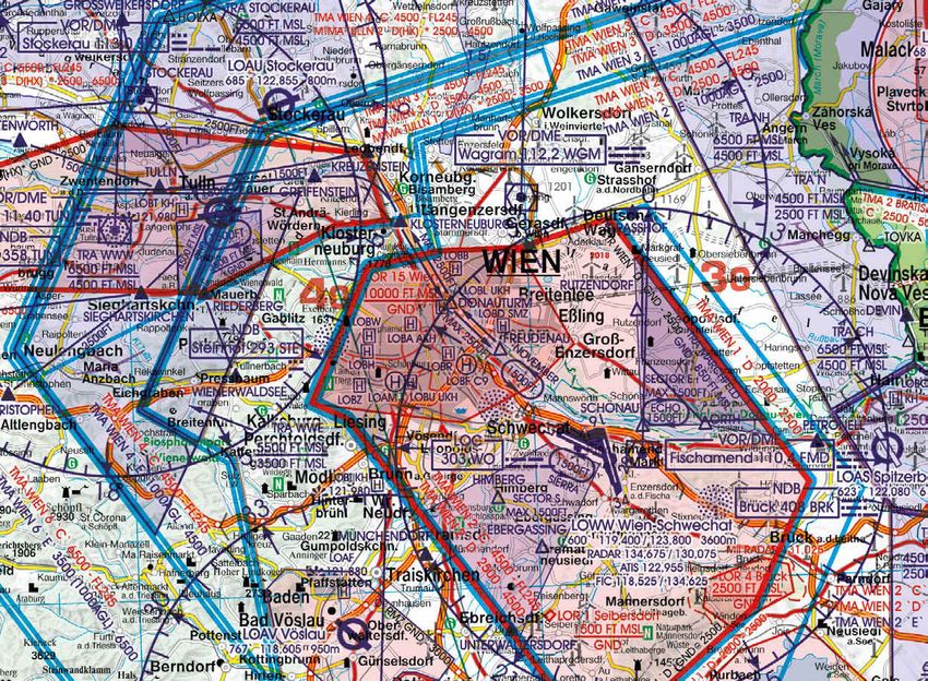
All prices incl. VAT VFR AERONAUTICAL CHARTS 29Austria Rogers Data VFR chart, 1:500.000
TRA Stockerau Border Crossing Point
(temporary reserved airspace) (significant point)
Airspace Relevant frequencies
(TWR, RADAR, ATIS, FIC)
30 VFR AERONAUTICAL CHARTS
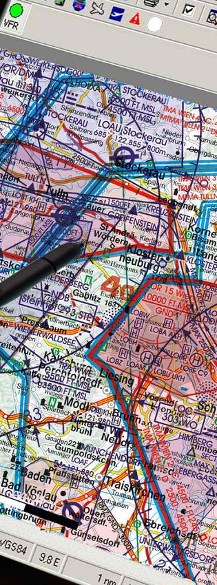
Austria Rogers Data chart, 1:500.000Lower-Austria & Vienna Rogers Data VFR chart, 1:200.000
VFR reporting point Model airfields
Hospital Holding Detailed topographic
information
VFR AERONAUTICAL CHARTS 31VERWENDEN SIE
IMMER AKTUELLE,
ZWECKDIENLICHE
KARTEN
VFR Karten müssen die aktuelle Luftraumstruktur, die Rogers Data VFR Luftfahrtkarten beinhalten TMZ
aktuellen Frequenzen und Verfahren sowie die für den Lufträume mit vorgeschriebener Transponderschaltung,
jeweiligen Flug relevante Strecke inklusive Ausweich- RMZ Zonen mit Funkkommunikationspflicht, Flughä-
maßnahmen beinhalten. fen, Flugplätze und Hubschrauberlandeplätze mit De-
tailangaben. Darüberhinaus Pflichtmeldepunkte, Mel-
Es gibt keine Vorschrift, Verordnung und kein Gesetz, depunkte auf Anforderung und Grenzüberflugspunkte
dass nur bestimmte Kartenangebote oder Karten von (Border Crossing Points, Significant Points). Funknavi-
bestimmten Anbietern erlaubt wären. Die Meinung, gationsanlagen mit Namen, Frequenz und Kennung im
dass nur behördlich herausgegebene VFR Karten oder Morsecode. Gefahren-und Flugbeschränkungsgebiete,
behördlich zertifizierte VFR Karten zum Fliegen ver- Luftfahrthindernisse oder Gruppen von Hindernissen,
wendet werden dürfen, basiert auf keiner gesetzlichen Luftsportgebiete und Gebiete mit Erholungsaktivitä-
Grundlage. Weiters gibt es keinerlei Vorschrift hinsicht- ten und Naturschutzgebiete mit fliegerisch relevanten
lich der Form, in der aktuelles Kartenmaterial vorzulie- Einschränkungen (Naturschutzgebiete und National-
gen hat. Der Begriff „Luftfahrtkarte“ bezieht sich auf alle parks) sind ebenfalls eingezeichnet.
Arten von Karten, die zur Navigation und zum Fliegen
verwendet werden, sofern sie die folgenden Informatio- Back-Up gem. ICAO Annex 4
nen enthalten: topographische Merkmale, Gefahren und Als Pilot sollten Sie sich mit den verfügbaren Kar-
Hindernisse, Navigationsrouten und -hilfen, Lufträume ten vertraut machen und nach Ihren Bedürfnissen
und Flughäfen. und Vorlieben entscheiden. Trotz der zunehmenden
Beliebtheit elektronischer Karten ist es ratsam, Ba-
Rogers Data VFR Luftfahrtkarten - ICAO Karten erfül- ckup-Systeme bereitzuhalten, um sie im Bedarfs-
len diese Anforderungen und enthalten alle Informa- fall zur Verfügung zu haben. Außerdem erlaubt die
tionen, die zum Fliegen notwendig sind. Rogers Data Verwendung mehrerer Navigationssysteme einem
VFR Karten erfüllen einerseits die Anforderungen des Piloten, jedes System zu seinem Vorteil zu nutzen.
ICAO Annex 4 und der Europäischen Kommission und
entsprechen andererseits den Erwartungen der VFR Pi- Eine Papierkarte ist nach wie vor ein bewährtes System
loten. Wir kombinieren die rechtlichen Anforderungen für die Flugvorbereitung sowie bei der Flugwegauswahl
und Erwartungen der VFR Piloten an VFR Karten und und bietet aufgrund der Größe eine gute Übersicht.
produzieren qualitativ hochwertige Produkte.
ICAO Annex 4 sieht dezidiert die Möglichkeit eines
Selbstverständlich können VFR Karten als Papierkarte Back-ups mittels Papierkarten vor. Mit der Mitnahme
und in elektronisch lesbarer Form mitgeführt werden. der Rogers Data Papierkarten erfüllen Sie die Vor-
Entscheidend ist die Aktualität und Eignung für die schrift zur Verfügbarkeit eines Back-Up-Systems. Die
Luftfahrt. Was immer Sie tun, machen Sie es richtig. - Rogers Data VFR Luftfahrtkarten – ICAO Karten er-
Wählen Sie Ihre bevorzugte Kartenart - digitale oder in füllen die Anforderungen.
gedruckter Version.
Mehr Informationen über Bestimmungen und
Rogers Data VFR Luftfahrtkarten verfügen über eine Vorschriften: www.rogersdata.at
sehr detaillierte Darstellung der jeweiligen Lufträume.
Als Kartengrundlage verwenden wir eine hochwertige
topografische Karte mit Schummerung und Relief. Da-
durch entsteht ein dynamischer 3D- Eindruck.
32 CURRENT AND SUITABLE VFR CHARTSALWAYS USE Rogers Data VFR aeronautical charts – ICAO charts
have a very detailed representation of ATS airspace
CURRENT AND
structures. We use a high-quality topographic map with
shading and relief. This creates a dynamic 3D impressi-
on. Rogers Data VFR aeronautical charts include TMZ
SUITABLE CHARTS transponder mandatory zones, RMZ radio mandatory-
zones, airports, aerodromes and heliports with additio-
nal information, compulsory reporting points, reporting
VFR aeronautical charts have to cover the current points on request, significant points (border crossing),
airspace structure, frequencies and procedures, the rou- Radio Navigation Aids with name, frequency and morse
te of the planned flight and any route which it is reason- code, obstacles or group of obstacles and aerial spor-
able to expect that the flight may be diverted to. ting and recreational activities, areas with sensitive fau-
na (Natural Parks and Areas Subject to Natural Fauna
There is no rule, regulation or law that requests that only Protection).
certain certified charts or charts from specific suppliers
have to be used. The opinion that only goverment is- A major advantage of Rogers Data VFR aeronautical
sued VFR charts or charts issued by a certain autho- charts – ICAO charts is the fact that they are available in
rity may be used for flying, is not written down in the digital versions and print versions. You can see the same
law. Furthermore, there is no rule regarding the form in chart image on the screen and on the printed map that
which the latest chart material has to be present. you are holding in your hand.
The term „aeronautical chart“ refers to all sorts of maps
used for air navigation provided that they include at Back-Up Arrangements according to ICAO Annex 4
least some of the following information: topographic As a pilot you should familiarize yourself with the availa-
features, hazards and obstructions, navigation routes ble charts and decide according to your needs and pre-
and aids, airspace, and airports. ferences. Despite the increasing popularity of electronic
charts, it is only wise to keep backup systems ready to
Rogers Data VFR aeronautical charts – ICAO charts have them available in case you need them. In addition,
are conform to these requirements and contain infor- using multiple systems for navigation allows a pilot to
mation that is important for flying. On one hand Ro- use each system to it`s advantage.
gers Data VFR charts meet the requirements of ICAO
Annex 4 and European Commission Regulations and on A paper VFR aeronautical chart is still a proven system
the other hand meet the expectations of VFR pilots. We for flight preparation, flight route selection and provides
are able to combine the requirements and expectations an overview due to its size.
of VFR pilots for VFR aeronautical charts and provide
highly sophisticated and optimized products. ICAO Annex 4 regulates that a suitable back-up system
may include the carriage of paper charts. By taking the
Of course, charts may be carried as a paper chart and Rogers Data VFR aeronautical charts – ICAO charts
in electronically readable format. The critical factor is in paper version with you, you are conform with the
currency and suitablility. Whatever you do, do it right. regulations for a back-up system.
Choose your preferred type of map - digital or print ver-
sion. More information about rules and regulations:
www.rogersdata.at
CURRENT AND SUITABLE VFR CHARTS 33„always keep current & suitable VFR aeronautical charts on board“
AIRSPACE REVISIONS
www.rogersdata.at/en/airspace-revisions

LUFTRAUMÄNDERUNGEN
www.rogersdata.at/luftraumaenderungen

                                          www.rogersdata.at
ICAO Anhang 4, EU-Verordnung ICAO Annex 4, EU-Regulation
VFR Luftfahrtkarten VFR Aeronautical Charts
Rogers Data VFR Luftfahrtkarten werden gemäß den Rogers Data VFR aeronautical Charts are made accor-
einschlägigen Bestimmungen des ICAO Annex 4 „Ae- ding to ICAO Annex 4 „Aeronautical Charts“, based on
ronautical Charts“ (Luftfahrtkarten) sowie den rele- relevant regulations of European Commission Regula-
vanten EU-Bestimmungen erstellt. Darüber hinaus tions and the latest aeronautical information from AIP
basieren sie auf den neuesten Luftfahrtinformationen (Aeronautical Information Publication) and their sup-
aus AIP (Aeronautical Information Publication, Luft- plements of the CAA (Civil Aviation Authority) of each
fahrthandbuch) und deren Supplements der CAA (Ci- competent authority.
vil Aviation Authority).
These regulations (ICAO Annex 4; EU regulations) re-
Diese einschlägigen Bestimmungen (ICAO Annex 4; gulate that VFR aeronautical charts have to be “current
EU-Verordnung) regeln, dass VFR Luftfahrtkarten „ak- and suitable”. Furthermore ICAO Annex 4 regulates
tuell und zweckdienlich“ sein müssen. Weiters regelt that an appropriate back-up system is mandatory in
ICAO Annex 4, dass neben der Verwendung von digita- addition to the use of digital aeronautical charts. In this
len VFR Luftfahrtkarten ein geeignetes Back-Up System context ICAO explains that paper charts may be a suita-
zwingend erforderlich ist. In diesem Zusammenhang ble back-up system.
gibt ICAO vor, dass Papierkarten ein geeignetes Back-
Up System sind. (…) a suitable back-up system may include the carria-
ge of paper charts. [20.6 „Back-up Arrangements“ to
(…) a suitable back-up system may include the carria- Annex 4 to Convention on International Civil Aviation]
ge of paper charts. [20.6 „Back-up Arrangements“ to
Annex 4 to Convention on International Civil Aviation]
Annex 4 to the Convention on International Civil
Aviation | 20.6 Back-up arrangements
To ensure safe navigation in case of a failure of the
Electronic Aeronautical Chart Display - ICAO, the
provision of adequate back-up arrangements shall
include:
a) facilities enabling a safe takeover of display func-
tions
in order to ensure that a failure does not result in a
critical situation; and
b) a back-up arrangement facilitating the means for
safe navigation of the remaining part of the flight.
Note.- A suitable back-up system may include the
carriage of paper charts. (ICAO Annex 4)
36 RULES AND REGULATIONSAbfangverfahren & Signale an Bord Interception procedures & signals on board
Seit 25. August 2016 müssen Informationen über Ab- Since 25th August 2016 information of interception
fangverfahren und - signale an Bord eines Luftfahrt- procedures and signals must be carried on board of an
zeuges mitgeführt werden, da die Opt-Out-Regelung aircraft, because the publication of Opt-Out of Com-
der Verordnung (EU) Nr. 800/2013 der Kommission mission Regulation (EU) No. 800/2013 and Commis-
und der Verordnung (EU) Nr. 965/2012 der Kommis- sion Regulation (EU) No. 965/2012 ended with 25th
sion mit 25. August 2016 endete. Unser Rogers Data August 2016. Our Rogers Data Austria VFR Trip Kit
Austria VFR Trip Kit enthält die entsprechenden Infor- contains the relevant information and illustrations on
mationen und Abbildungen auf den Seiten ENR 4.1-1 pages ENR 4.1-1 to ENR 4.1-5. By taking the Rogers
bis ENR 4.1-5. Mit dem Mitführen des Rogers Data Data VFR Trip Kit with you, you are conform with tho-
VFR Trip Kits erfüllen Sie die Anforderungen dieser se regulations.
Verordnung.
Part-CAT (Annex IV to Commission Regulation
(EU) No 965/2012) Commercial air transport ope-
Commission Regulation (EU) No 965/2012 of 5 Oc-
rations
tober 2012 laying down technical requirements and
administrative procedures related to air operations
CAT.GEN.MPA.180
pursuant to Regulation (EC) No 216/2008 of the
Documents, manuals and information to be carried
European Parliament and of the Council
a) The following documents, manuals and informa-
tion shall be carried on each flight, as originals or
Part-NCO (ANNEX VII to Commission Regulation
copies unless otherwise specified:
(EU) No 965/2012) „Non-Commercial air operations
13. procedures and visual signals information for
with other-than-complex motor-powered aircrafts“
use by intercepting and intercepted aircraft
NCO.GEN.135
Documents, manuals and information to be carried
a) The following documents, manuals and informati-
on shall be carried on each flight as originals or copies
unless otherwise specified:
11. procedures and visual signals information for
use by intercepting and intercepted aircraft
Part-NCC (Annex VI to Commission Regulation
(EU) No 965/2012) „Non-Commercial Air Opera-
tions with
complex motor-powered aircrafts“
(fig above.:
NCC.GEN.140 Rogers Data VFR Trip Kit 200
Documents, manuals and information to be carried Interception procedures and
a) The following documents, manuals and informati- signals on board“)
on shall be carried on each flight as originals or copies
unless otherwise specified: You will find more information
12. procedures and visual signals information for about our VFR Trip Kit 200k on
use by intercepting and intercepted aircraft page 41.
RULES AND REGULATIONS 37Part-NCC (Anhang VI to Regulation (EU) No. CAT.GEN.MPA.180
965/2012, Regulations (EU) No. 379/2014) „Com- Documents, manuals and information to be carried
position of applicable regulations concerning ae- a) The following documents, manuals and informa-
ronautical charts„ tion shall be carried on each flight, as originals or
copies unless otherwise specified:
NCC.GEN.140 12. current and suitable aeronautical charts for
Documents, manuals and information to be carried the route of the proposed flight and all routes along
a) The following documents, manuals and informati- which it is reasonable to expect that the flight may
on shall be carried on each flight as originals or copies be diverted
unless otherwise specified:
11. current and suitable aeronautical charts for CAT.GEN.MPA.190
the route of the proposed flight and all routes along Provision of documentation and records
which it is reasonable to expect that the flight may be The commander shall, within a reasonable time of
diverted (…) being requested to do so by a person authorised by
an authority, provide to that person the documenta-
Part-NCO (Annex VII to Regulation (EU) No. tion required to be carried on board.
965/2012, Regulation (EU) No. 379/2014)
„Non-commercial with other-than complex mo- CAT.OP.MPA.175 Flight preparation
tor-powered aircraft“ a) An operational flight plan shall be completed
for each intended flight based on considerations
NCO.GEN.135 of aircraft performance, other operating limitations
Documents, manuals and information to be carried and relevant expected conditions on the route to
a) The following documents, manuals and informati- be followed and at the aerodromes/operating sites
on shall be carried on each flight as originals or copies concerned
unless otherwise specified b) The flight shall not be commenced unless the
10. current and suitable aeronautical charts for the commander is satisfied that:
route area of the proposed flight and all routes along 5. current maps, charts and associated documen-
which it is reasonable to expect that the flight may be tation or equivalent data are available to cover the
diverted (…) intended operation of the aircraft including any
diversion that may reasonably be expected
AMC1 NCO.GEN.135(a)(10)
Documents, Manuals and Information to be carried CAT.IDE.A.355 Management of aeronautical data-
CURRENT AND SUITABLE AERONAUTICAL bases
CHARTS b) The operator shall ensure the timely distribution
(a) The aeronautical charts carried should contain and insertion of current and unaltered aeronautical
data appropriate to the applicable air traffic regula- databases to all aircraft that require them.
tions, rules of the air, flight altitudes, area/route and
nature of the operation. Due consideration should be SPA.HEMS.130 Crew requirements
given to carriage of textual and graphic representa- e) Crew composition
tions of: 2. Night flight. The minimum crew by night shall be:
(1) aeronautical data, including, as appropriate for the i) two pilots; or
nature of the operation: ii) one pilot and one HEMS technical crew member
(i) airspace structrure; in specific geographical areas defined by the opera-
(ii) significant Points, Navigation aids (navaids) and tor in the operations manual taking into account the
air traffic services (ATS) routes; following:
(iii) navigation and communication frequencies; A. adequate ground reference;
(iv) prohibited, restricted and danger areas; and B. flight following system for the duration of the
(v) sites of other relevant activities that may hazard HEMS mission
the flight; (…)
38 RULES AND REGULATIONSSPO.GEN.140
Documents, manuals and information to be carried
a) The following documents, manuals and informati-
on shall be carried on each flight as originals or copies
unless otherwise specified below
12. current and suitable aeronautical charts for the
route/area of the proposed flight and all routes along
which it is reasonable to expect that the flight may be
diverted
13. procedures and visual signals information for
use by intercepting and intercepted aircraft
SPO.OP.115 Departure and approach procedures -
AEROPLANES AND HELICOPTERS
a) The pilot-in-command shall use the departure and
approach procedures established by the State of the
aerodrome, if such procedures have been published
for the runway or FATO to be used.
b) The pilot-in-command may deviate from a publis-
hed departure route, arrival route or approach proce-
dure:
1. provided obstacle clearance criteria can be obser-
ved, full account is taken of the operating conditions
and any ATC clearance is adhered to; or
2. when being radar-vectored by an ATC unit
c) In the case of operations with complex motor-po-
wered aircraft, the final approach segment shall be
flown visually or in accordance with the published
approach procedures.
CAT.OP.MPA.135 Routes and areas of operation -
GENERAL
a) The operator shall ensure that operations are only
conducted along routes, or within areas, for which:
1. space-based facilities, ground facilities and ser-
vices, including meteorological services, adequate for
the planned operation are provided
2. the performance of the aircraft is adequate to com-
ply with minimum flight altitude requirements
3. the equipment of the aircraft meets the minimum
requirements for the planned operation; and
4. appropriate maps and charts are available.
(..)
More information about Rules and Regulations:
www.rogersdata.at Areas with sensitive fauna and
national parks relevant for aviation;
Rogers Data 1:500.000
RULES AND REGULATIONS 39VFR TRIP KIT Rogers Data | Scale 1:200.000
Austria VFR Trip Kit, Scale 1:200.000

                       The Rogers Data VFR Trip Kit is a unique summary of all ci-
                       vil and military approach charts and aerodrome charts exis-
                       ting in Austria. Approach procedures, runway, reporting
                       points, frequencies, traffic pattem and VFR sectors are shown.
                       lt also includes all approach and aerodrome charts with an aerial pho-
                       to and all necessary information for VFR, also telephone accessibility
                       and opening times.

                       Format: DIN A5 size with spiral binding

                       For each aerdrome chart there is the matching approach chart.
                       More information about the Austria VFR Trip Kit:
                       www.rogersdata.at

                                                                                                  AUSTRIA VFR TRIP KIT, SCALE 1:200.000
                                                                             EUR 54,90
                                                                      AMDT 22 APR 2021
                                                                  recommended retail price

All prices incl. VAT                                                      VFR TRIP KITS      41
FLIGHT PLANNING Navigation, RDtech® Technology
Navigation Compass 200
 for VFR charts on a scale of 1:200.000

 Navigation Compass 250
 for VFR charts on a scale of 1:250.000

 Navigation Compass 500
 for VFR charts on a scale of 1:500.000

All prices incl. VAT                      FLIGHT PLANNING   43
Rogers Data Navigation Compass
1:200.000, 1:250.000 or 1:500.000
                                                         DISTANCE MEASUREMENT
WHAT`S THAT?                                             FLIGHT TIME
The Rogers Data Navigation Compass combines sec-
                                                         HEADING
tional plotter, time-speed-distance computer, ruler
and navigation compass template in a single device.      OPPOSITE TRACK
                                                         SPEED MEASUREMENT
HOW DOES IT WORK?
The Rogers Data Navigation Compass facilitates the       PATH-TIME MEASUREMENT
solution of navigation tasks and is easy to use!
Note: We provide different versions of Rogers Data       DIRECTION FINDING
Navigation Compasses for different map scales. Make
                                                         CIRCLE TEMPLATE AND RULER
sure to use the suitable navigation compass in corres-
pondence to the scale of the sectional chart.

                                                                         aircraft symbol
                                                                                                                „opposite track“
          Scan the QR code of your preferred               compass leg
                                                                                                                    marker

          language and watch the video of the                                                               scale
          explanation of how the Rogers Data
          Navigation Compass works.
                                                                                   mark
                                                          center line
                                                                                                       second compass leg

                                                                                                     line

                                                                                                 meridian north

       VIDEO                  VIDEO
     DEUTSCH                 ENGLISH

                                                                               Made in Austria.
                                                                               Rogers Data GmbH in cooperation with
                                                                               GEOtec Zeichen- und Kunststofftechnik GmbH.

44   FLIGHT PLANNING                                                                            All prices incl. VAT
Navigation Compass 200, 250 or 500
Production in cooperation with ARISTO
• For VFR charts on a scale of 1:200.000, 1:250.000 or 1:500.000
LEATHER OR NYLON COVER
• Distance and path-time measurement
• Flighttime distance and heading computer in single device
• Compass template and ruler
• Distance picked up with the tips - read distance between two points
• Required flight time between two points could be read in minutes
• Mounted concentric compass scale
• Headings with associated opposite course can
be determined on the back side
• Highlighting of navigation points EUR 34,90 / compass
recommended retail price
Nylon Cover for Rogers Data Navigation Compass
NAVIGATION COMPASS 200, 250 OR 500
This eye-catching and beautifully crafted cover is made of durable
nylon fibre and features a protective velour lining. The cover is made
specially for the Rogers Data Navigation Compass. The Rogers Data
Navigation Compass is well protected by the cover and can be easily
stored and removed from it. This way you always have your helpful
tool for flight preperation and inflight calculation with you on a pro-
fessional basis.
EUR 24,90
recommended retail price
Leather Cover for Rogers Data Navigation Compass
This shapely and exquisitely crafted cover is made of high quality,
eco-friendly recycling leather and fitted with a protective velour li-
ning. The cover is specially adapted to the Rogers Data Navigation
Compass. The Rogers Data Navigation Compass is well protected
within the cover and can be stored and taken out easily. This way
you always have your helpful tool for flight preperation and inflight
calculation with you on a professional basis.
EUR 24,90
recommended retail price
All prices incl. VAT FLIGHT PLANNING 45You can also read