Satellite Navigation - NextGEOSS has been selected by the European Commission to provide the European Hub for EO data distribution.
←
→
Page content transcription
If your browser does not render page correctly, please read the page content below

Satellite Navigation

NextGEOSS has been selected by the European Commission to provide the
European Hub for EO data distribution.

                                                                        1
1

    NextGEOSS is the European contribution to GEOSS, a global system of
    systems being put in place by GEO, and is implementing a federated data
    hub for access and exploitation of Earth Observation data.

    The NextGEOSS team is composed of 27 entities in total, including lead European
    companies and institutions, active in GEO-related and many other European, ESA
    and international activities in the domain of Earth Observation. The Consortium
    covers 13 European countries: Belgium, Czech Republic, France, Germany, Greece,
    Italy, Luxembourg, Netherlands, Norway, Portugal, Spain, Switzerland and the UK.

    PROJECT
    The NextGEOSS is all about providing the data and resources to the users
    communities, together with access to Cloud infrastructures, seamlessly connected
    to provide an integrated ecosystem for supporting applications - adding to the
    existing components of GEOSS.NextGEOSS has a special focus on encouraging and
    stimulating data exploitation. Capacity building is also at the heart of NextGEOSS,
    through the identification of training needs, to encourage wider user-engagement
    with EO data and unlocking its potential.

    APPROACH
    While continuing to support the GEO-DAB and OpenSearch as the middleware
    components in charge of interconnecting the heterogeneous and distributed
    capacities contributing to GEOSS, NextGEOSS focuses on a fundamental change to
    facilitate the connectivity to the European and global data centres with new
    discovery and processing methods to support innovation and business. It will
    leverage Web and Cloud technologies, offering seamless and user-friendly access to
    all the relevant data repositories, as well as providing efficient operations for
    search, retrieval, processing/re-processing, visualization, analysis and combination
    of products from federated sources.

   Delivers the next             Engages communities               Advocates GEOSS as a
 generation data hub              promoting innovative              sustainable European
 and EO exploitation for             GEOSS powered                  approach for EO data
innovation and business.        applications from Europe.              distribution and
                                                                         exploitation.
2

OBJECTIVES
In order to support the creation and deployment of EO-based innovative research
activities and commercial services, the project relies on three main pillars:

Engage
NextGEOSS has a focus on engaging a strong community of providers of EO data,
and current and potential system users. It provides a framework to ease the
discovery and retrieval of this data (satellite-based remote sensing and in situ
measurements) using best practices for search services, including standardized and
harmonized access to metadata and data coming from EO providers worldwide.

Deliver
NextGEOSS facilitates the connectivity to the European and global data centers
with new discovery and processing methods. It exploits the latest advances in EO
data management, and will provide virtualized work environments and the
necessary interfaces to leverage the storage and computing resources of private
and commercial providers.

Advocate
NextGEOSS advocates the use of GEOSS by organizing regular events, including
annual high-profile summits. Furthermore, the Online Courses and Learning Kit will
support the adoption of GEOSS technologies, through worldwide web-based events,
supported by the dedicated learning material focused on empowering communities
to use GEOSS data sources.

                                           Running from the end of 2016 until mid-
                                           2020, NextGEOSS will provide a streamlined,
                                           European hub for Earth Observation data
                                           discovery and retrieval, catering for European
                                           institutions as well as private sector needs in
                                           terms of Earth Observation data, ICT and
                                           services. It will engage global communities of
                                           data providers and GEOSS users, promoting
                                           pilot activities towards innovative GEOSS
                                           powered applications using GEOSS.
3

    METHODOLOGY
    The NextGEOSS project runs for 42 months, consisting of the following four
    stages:

    1) a six months initial preparation and setup period, where all preparation
    activities for the catalogue, engagement, communication and engagement of
    communities take place;

    2) a second period of integration of the pilot activities and development and setup
    of the catalogue tools, including data discovery and QoS, where external
    stakeholders start to be approached and engaged, and the communication and
    dissemination strategy is consolidated;

    3) a third period of consolidation and operationalization of system and pilots, with
    full engagement of identified communities, and where the assessment of potential
    benefits is performed;

    4) a fourth period of consolidation and operationalization of the system pilots and
    evolution, with successive interactions between the system and users (pilots)
    working together towards seamless integration through evolutive maintenance,
    with the sustainability assessment activities running at full speed; and

NextGEOSS has an Advisory Board,
which offers expert advice, and provides
a wider network to both collect input
and reach out the outcomes from the
project. The Advisory Board provides
constructive criticism and guidance at
the highest level.
1

EXPECTED IMPACTS
EI-1 Contribute to improved user-friendly discovery, access, and exploitation of EO
     data and information in Europe

EI-2 Contribute o strengthened European regional approach to GEOSS

EI-3 Contribute to broader update of GEOSS and Copernicus data, information and
     services

EI-4 Contribute to increased EO-driven innovation and business opportunities for
     European SMEs and companies

EI-5 Contribute to wider commercial exploitation of EO data and products beyond
     sectors that are not traditionally engaged in EO

EI-6 Contribute to increased European capacity to address GEOSS societal
     challenges of prime importance to the EU

PARTNERS
5

DATA CATALOGUE AND ACCESS
CKAN is the data management system used in NextGEOSS to make data
accessible – by providing tools to streamline publishing, sharing, finding and using
data. CKAN’s key functionalities are:
o To ensure the storage and catalogue of the datasets identified/ metadata
o To provide a web-based user interface to navigate on the information
o Basic Data Visualization and Geospatial capabilities

CKAN’s harvesting engine ingests data from authorized data sources and
generates metadata using on pre-defined schemas compliant with INSPIRE. Its
catalogue stores and catalogues the data and the metadata in a high-performance
search engine library, while the files are stored in a configurable location on the
filesystem in the original format.

DATA MINING AND DISCOVERY
It is a known challenge that GEOSS datasets might be difficult to find or
otherwise not easily accessible. To help ensure that more users benefit from
GEOSS data, special attention will be given to better cataloguing datasets and
enriching the metadata of the datasets. NextGEOSS builds on the sophisticated
search techniques that CKAN already offers. All of the search features can be
combined into a multi-featured search. Existing proven methods of enhancing
datasets' metadata through automated inspection will be combined with
previous work done on metadata enhancement of GEOSS data. NextGEOSS
also explores data mining techniques to further enhance the discoverability of
datasets.

DATA PROVIDER QUALITY OF SERVICE
NextGEOSS aims at meeting a high service quality, to adequately foster the
private and public sector. The Quality of Service (QoS) component of
NextGEOSS provides an assessment of the system’s distributed infrastructure
capabilities by the users themselves. During low access periods, all relevant
parts of the infrastructure are to be verified on a random-choice basis. Probed
products are taken randomly out of the Data Catalogue, which contains
metadata on all registered NextGEOSS products. The QoS componenent yields
all necessary metadata to a consistent description about where (at which URL) a
product is accessible by which service (e. g. WMS, WMS-T, WCS, WFS, etc.) and
what product type (image, NetCDF dataset, JSON) is expected as answer. These
tests-check are performed on a defined reasonable number of randomly chosen
products and services. The result of these tests is the identification and
correction of failures and bottlenecks of operational data provider.
6

USER INTEGRATION SUPPORT
The data processing infrastructure used in NextGEOSS is based on a Cloud
Computing Platform-as-a-Service (PaaS) approach, in which applications are
integrated using Virtual Machines with their own specifications that run on private
(physical deployment over local hardware) or commercial Cloud infrastructures.
The Virtual Machines are appliances running on an infrastructure managed by a
Cloud Controller, and accessible as an independent domain once instantiated.
The Cloud appliances are initially a Development Environment where applications
or services are integrated and then are moved to Production Centers when fully
deployed for their exploitation. The Development Environment provides
developers with tools and services that support the implementation and
deployment of applications in a sandbox to fully exploit the power of distributed
computing on a Cloud Infrastructure-as-a-Service (IaaS). When fully deployed in
production it allows users to instantiate (on-demand) a processing service
appliance, provision the appliance on a pre-configured ICT Provider and invoke
the processing via the Open Geospatial Consortium (OGC) Web Processing Service
interface or directly in a Cloud appliance marketplace.

COMMUNITY FEEDBACK MECHANISM
The Community Feedback Mechanism promotes the sharing of users’ feedback on
the resources included on the GEOSS Common Infrastructure (GCI). This is of
paramount importance as it is a direct mechanism to raise users’ voices and
promote interaction between users and data providers.
This simple feedback mechanism is the first element of a system that will turn the
GCI into a marketplace where providers can react to user-feedback and create
datasets that are better adapted to user’s needs. Additionally, the work developed
for the Community Feedback Mechanism also takes advantage of other parts of
the system, for example the Single Sign-On (SSO) system, allowing
communication with users after they download a resource from the GCI, to
suggest they join the community by creating a feedback item about the resource,
and asking them if they want to be updated on the feedback related to this
resource.

                                              SUSTAINABILITY
                                              The best mechanism to support long-
                                              term usage of NextGEOSS within user
                                              communities will be assessed, and
                                              critical success factors, potential risks
                                              and inhibitors will be identified. The
                                              feedback of users will be used to design
                                              a set of recommendations and a
                                              roadmap to deliver the most sustainable
                                              approach to services’ generation and
                                              utilization brought by NextGEOSS.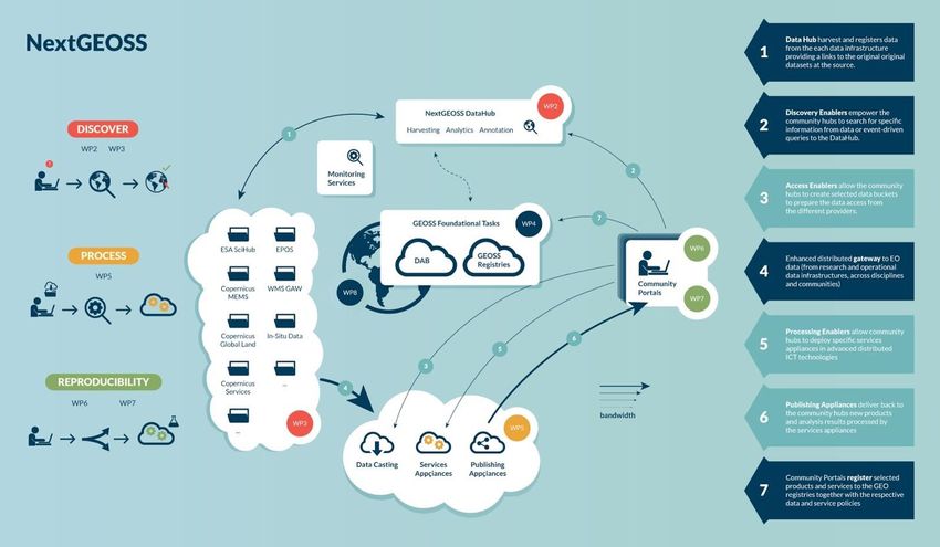
7

   OPENING UP TO THE PRIVATE SECTOR
   NextGEOSS significantly contributes to the implementation of GEO’s strategic plan
   with respect to advancing and facilitating cooperation with the private sector. With
   the support of private partners, NextGEOSS team is involving the Earth
   Observation value-adding companies and data providers, contributing to and
   supporting the creation of a potential marketplace, with a focus on meeting the
   needs of the international GEO community.

   ENGAGEMENT ACTIVITIES
   GEO’s vision is of a “future wherein decisions and actions for the benefit of
   mankind are informed by coordinated, comprehensive and sustained Earth
   observations.” NextGEOSS is engaging with the GEO implementation mechanisms
   (GEO Flagships, GEO Initiatives, Community Activities & Foundational Tasks) to
   support GEO’s vision and to evolve the GEOSS and GEO Portal. The engagement
   mechanism is:
   o Stimulate GEOSS Powered applications
   o Architecture Implementation Pilots
   o Promote Open Data Policies
   o Summits
   o Engagement with the Private Sector

   DISSEMINATION
   NextGEOSS maximizes its impact through an effective yet differentiated
   communication strategy adhering to the complexity of stakeholders, a strategy in
   line with the GEO Engagement Strategy.
   NextGEOSS extracts stories from all the project activities, but especially from the
   pilots, covering a multitude of societal application areas and actors. The
   communication strategy is implemented using a mix of new and traditional tools in
   order to be efficient, strongly interact, and reach the inhomogeneous audience that
   is necessary in order to maximize the impact.

BUSINESS INNOVATION
The objective is to assess the delta
between geospatial services available
today, and the expected improvements of
services to end-users brought about by
the implementation of NextGEOSS. The
additional benefits are to be assessed
both economically and non-economically
(including social benefits).

8

PILOTS
NextGEOSS supports several pilot applications that address key GEOSS societal
challenges, and directly engage researchers and developers, providing them with
specific tools and scalable Cloud appliances, covering their requirements. Focusing
on sustainable development and climate change mitigation, and adaptation
strategies, NextGEOSS directly involves important actors in these areas. Different
topics are addressed by the NextGEOSS pilots, directly contributing to increase the
European capacity within and leveraging of GEOSS.

Through the innovative research pilots and the more business oriented
pilots, NextGEOSS supports the partners, not normally focused or adapted to see
their business delivered by a platform, to benefit from the different economic
models provided by Cloud computing for big data processing. Strategies like
subscription-based delivery model lower up-front cost, eliminating the initial capital
investment. The Cloud readiness of existing data infrastructures is also being
accessed together with the support of a federated solution taking in consideration
data product accessibility. Through the additional engagement activities promoted
by the project as well as the communication and training activities and material
made available, NextGEOSS seeks to widen significantly its base of supporters,
providers and users, into becoming the preferred European hub for data access and
distribution by the European GEO community.

NextGEOSS includes a set of demonstrative pilot activities, which will showcase the
system’s capabilities:

                          IP1:                                                       IP3:
                                                        IP2:                                           IP4:
                      Agricultural                                                 Space &
                                                    Biodiversity                                   Cold Regions
                      Monitoring                                                   Security
Innovative
 Research

                                                        IP5:                         IP6:
                                                   Air Pollution                 Disaster Risk
                                                  in Mega Cities                  Reduction
  Business

                          BP1:
                                                      BP2:                          BP3:              BP4:
                       Territorial
                                                  Food Security                  Smart Cities        Energy*
                        Planning

             * ARMINES will conduct two use-cases for the benefit of the GEOSS Energy community.
9

IP1: TIME SERIES ANALYSIS FOR AGRICULTURAL MONITORING
This pilot has a focus on the analysis of time series of data, both EO-data from
satellite missions (Proba-V as time series spanning multiple years and Sentinel-2
as a time series over a growing season), and in-situ measurements related to
agronomy and meteo. To realise this, three components are in scope:

• Time Series Viewer, as an existing application from the Proba-V Mission
  Exploitation Platform (MEP) - https://proba-v-mep.esa.int, will be extended
  towards high-resolution vegetation parameters derived from Sentinel-2 which
  are calculated on the NextGEOSS cloud. This ‘data analytics’ will provide the
  back-end for the pilot on Crop Monitoring. A RESTful Web Service endpoint will
  be integrated in the NextGEOSS Data Hub;

• Agro STAC viewer (Spatial Temporal Attribute Catalogue for Agronomy), as a
  prototype developed by VITO and Alterra in the FP-7 SIGMA project to visualise
  and explore time series of in-situ data: http://agrostac.vgt.vito.be/stac.html,
  will be extended in functionality and the prototype will be operationalised and
  promoted to relevant user communities. Field data is collected from a number
  of sites worldwide, mainly agronomy data relevant for calibration/validation
  purposes in the domain of crop production monitoring by satellite data.
  Examples of data served by STAC are crop type, phenology, biomass, Leaf Area
  Index (LAI), yields, canopy height, etc.;

• Guidelines and improved prototype of WMTS will be generated, supporting
  better the time dimension and tile quality information.

Geographical Area
Global coverage.

Data
Proba-V, Copernicus Global Land, vegetation indices derived from Sentinel-2, in-
situ measurements for agronomy and meteo from different stations worldwide.
10

   IP1: TIME SERIES ANALYSIS FOR AGRICULTURAL MONITORING

   Context

   Food Security, global vegetation monitoring and many other areas need consistent
   time series of high-quality Earth Observation data and in-situ data. Such a service
   which allows users to explore and view the time series without having to
   download the data, can support many services as demonstrated in Crop
   Monitoring Supporting Food Security – NextGEOSS pilot.

   Target Community

   Many scientific users rely on easy access to long time series of EO data and in-situ
   data for validation over different test sites worldwide. Governmental users can
   use the Time Series views as well to get a quick view on the status of vegetation
   in a specific country, region or point in support of emergency response.
   Commercial users, such as insurance companies or farmers can integrate the
   service in their applications.

   Expected Outcome

   The pilot will provide a data analytics backend supporting dashboard where users
   can explore vegetation indices derived from multiple EO sensors          including
   Sentinel-2. This backend will be integrated in pilot 7.2 to support the high
   resolution crop monitoring pilot. Also a
    tool to visualize and explore time series of in-situ data will be developed and
   promoted, together with advancements on the OGC standard WMTS regarding
   time and quality

Result on GCI
The RESTful Web Service for the Time
Series Viewer will be integrated in the GCI.

              Consortium Partners
                    VITO, ALTERRA, UAB
11 IP2: BIODIVERSITY "Biodiversity pilot “RS-EBVs for biodiversity monitoring” has two major targets: • The first target is to focus on creating the biodiversity GEOhub. Importantly the GEOhub will offer sustainability beyond the project lifetime by embedding the biodiversity GEOhub with the GEO Global Initiative GEO-BON. The need for remote sensing for global EBVs is to fill the spatial and temporal gaps between in situ observation biodiversity data. Several steps remain in order to actualize the acquisition of the observations needed for these remote sensing EBVs. GEO, through its Global Initiative GEO BON, proposes to act as a hub to facilitate iterative discussion between space agencies (via CEOS) and key policy bodies (CBD, IPBES). • The second target concerns demonstrating the use of high resolution RS-EBVs for habitat monitoring in order to support amongst others the EEA and ETC/BD. These organisations have special responsibilities with regard to European habitats, with specific emphasis on the reporting obligations towards to the Birds and Habitat Directives. The spatial identification of European habitats and related changes are a difficult task, and much effort is nowadays being put in the spatial identification of EUNIS habitat types. Remote sensing data could play a much larger role than it has now, and a good integration of the large amount of in-situ field observations (vegetation plots) with high resolution RS- EBVs will be key. The integration of high resolution RS-EBVs will be demonstrated for forest and heathland habitats. Geographical Area Europe and specific regions in Europe such as the Netherlands, Bavarian Forest National Park, and Catalonia. Data • Environmental predictors such as: potential evapotranspiration, solar radiation, seasonality, mean temperature, annual precipitation, distance to water, bulk density of the soil, cation exchange capacity of the soil, soil organic carbon content, soil pH, etc. • RS-EBV's: such as LAI, vegetation phenology, land cover, leaf nitrogen content, inundation, vegetation height • Ground truth observations of European habitats
12

   IP2: BIODIVERSITY

   Context

   The biodiversity community still lacks a global observing system for biodiversity
   monitoring. Such a gap is worrying, as operational observing systems are key to
   coordinating globally consistent data collection across all dimensions of
   biodiversity. Therefore there is an urgent need from the remote sensing
   community to feed information towards EBVs to fill the spatial and temporal gaps
   in between in-situ biodiversity observation data from the field

   Target Community

   Several RS-EBVs are anticipated to be derived from satellite remote sensing. The
   focus is on supporting a biodiversity GEOhub and modeling the spatial distribution
   of European habitats, which serve the various biodiversity communities (not
   onlyGEO-BON, CBD and IPBES, EEA, ETC/BD, and many smaller organisations
   interested in biodiversity).

   Expected Outcome

   This task is focused on creating the biodiversity GEOhub for RS-EBV's which will
   support the GEOSS European Hub and provide full interoperability of biodiversity
   data. It will demonstrate the use of RS-EBVs for habitat monitoring by spatial
   modelling of EUNIS habitats (maps with spatial distribution of habitats).

Result on GCI
The web mapping tool for querying the
spatial distribution of European habitats
will be integrated in the GCI.

              Consortium Partners
           ALTERRA, U Twente DLR, UAB
13 IP3: SPACE AND SECURITY Earth Observation data for the Space and Security domain are currently showing an unprecedented scenario in terms of variety, volume, velocity, veracity and value. Thus the key challenge is to improve the capacity to access and analyse this huge amount of heterogeneous data to timely provide decision-makers with clear and useful information. One of the key product derived from these datasets is related to the identification of changes on the Earth surface. Change Detection is an important technique to support the monitoring of urban, built-up and natural environments in order to identify certain features and anomalies over areas of interest as well as the assessment of natural resources. Within this context, the objectives of the Space and Security pilot to be implemented in NextGEOSS are: • To provide tools for detecting and characterizing changes; • To explore methods for extracting information on changes at different scales; • To foster extensive exploitation of GEOSS Data Hub. The pilot will be built on the results of the activities currently performed by SatCen in the framework of two Horizon 2020 projects: BigDataEurope (Integrating Big Data, Software & Communities for Addressing Europe’s Societal Challenges) and EVER-EST (European Virtual Environment for Research Earth Science Themes). Geographical Area The pilot aims to allow the user to execute the provided services on specific area of interest, generally ranging from local to regional level. Data The Space and Security pìlot will foster the exploitation of data from the Sentinel satellites, part of the Copernicus programme, which guarantee open and up-to- date information through a set of services dedicated to security and environmental issues. In particular, Sentinel 1 and Sentinel 2 data will be used.
14

  IP3: SPACE AND SECURITY

  Context

  In the Space and Security domain (i.e. to ensure the wellbeing and security of
  countries and citizens by exploiting suitable space assets) it is crucial to improve
  the capacity to access and analyze the increasing amount of data produced with
  high velocity by a variety of sources. One of the main interest in exploiting such
  datasets in the Space and Security domain is related to the detection of changes
  on the Earth surface.

  Target Community

  The main users to benefit from the pilot are the stakeholders involved in the EO
  data exploitation for space and security purposes (e.g. decision makers in the EU
  and its Member States). Moreover, Change Detection is a transversal issue
  common to several user communities (e.g. environment, science and
  humanitarian aid).

  Expected Outcome

  The pilot will provide processing services (based on a chain of image processing
  operators mainly from open toolboxes) to identify changes on a specific areas of
  interest within a timeframe selected by the users. As output, the user will be able
  to retrieve and download the file with the detected changes.

Result on GCI
The services will be available on the GCI
GEOSS and each user will be able to login
using its own credentials. The outcome of
the service execution will be associated to
the specific user profile.

               Consortium Partners
                                  SATCEN
15 IP4: COLD REGIONS This pilot has a focus on showcasing examples of products for selected areas in Cold Regions, combining remote sensing data, in situ data and model products from relevant European infrastructures and international frameworks. The products will be made available through the NextGEOS Data Hub, for users and stakeholders in the GEO community, polar research and education. An initial list of products includes: • Sea ice type and drift maps for the Fram Strait, based on Sentinel-1 SAR data • Sea ice concentration for the Arctic; based on satellite altimeter and passive microwave data • CMEMS product Arctic Ocean physics analysis and forecast product • Near-surface atmospheric aerosol properties (near-real-time) at Zeppelin station, Svalbard. • Near-surface atmospheric aerosol properties (near-real-time) at Troll station, Queen Maud Land, Antarctica. • CAMS aerosol optical depth forecast product Additional products will be defined in dialogue with stakeholders during the course of the project, in close collaboration and dialogue with users and stakeholders in the GEO community. Geographical Area Selected areas in Cold Regions: (1) the Arctic/Svalbard region, (2) Antarctica, and (3) the Himalayan glaciers. Data Sea ice products from Sentinel and other satellites. Atmosphere products from observation networks such as WMO Global Atmosphere Watch (GAW) and Global Cryosphere Watch (GCW). Sea ice products, including model forecasts, from Copernicus Marine Environment Monitoring Service (CMEMS). Atmosphere products, including model forecasts, from Copernicus Atmosphere Monitoring Service (CAMS).
16

   IP4: COLD REGIONS

   Context

   GEO Cold Regions coordinates global efforts to provide Earth Observation (EO)
   products and services to science, decision- and policy-makers with a vested
   interest in the cryosphere (in particular) and the environment (in general) of polar
   regions and mountain areas around the world. The NextGEOSS Cold Regions Pilot
   will focus on three areas: (1) the Arctic/Svalbard region, (2) Antarctica, and (3)
   the Himalayan glaciers, and will address the existing shortage in accessing in situ
   data in GEOSS. We will liaise with ongoing initiatives such as SIOS, GEO-CRI,
   WMO GCW, as well as national programs in Antarctica.

   Target Community

   Results from the pilot will feed into the GEO community, in particular to SIF (the
   Standards and Interoperability Forum), GEOSS development and operations tasks
   such as GEOSS-EVOLVE WP1, and the GI-11 Information Services for Cold
   Regions. Results will also feed into education of PhD and young scientists, and will
   be used in capacity building material for other stakeholders.

   Expected Outcome

   The products resulting from this pilot can be used to develop Information Services
   for the Cold Regions Initiative, using the NextGEOSS system and making use of
   existing interoperability standards. The focus of the pilot will be on linking
   together satellite and in situ data from the targeted regions, including the
   atmospheric, marine, and terrestrial domains, and make them available in the
   NextGEOSS Data Hub and the Global Cold Regions Community Portal.

Result on CGI
Demonstration products will be
available from the GCI.

        Consortium Partners
                NERSC, NILU, BLB
17 IP5: AIR POLLUTION IN MEGA CITIES This pilot has a focus on the analysis of time series data of both, satellite missions (MetOp, Sentinel-3, Sentinel-5P), and model results from the Copernicus Atmosphere Monitoring Service. To realise the objectives it consists of four components: • Urban Area Selector (UAS) – An urban area of interest is interactively defined by the user on the basis of the Global Urban Footprint (GUF) in the web client. The GUF has been derived from EO data by worldwide mapping of settlements. A total of 180 000 TerraSAR-X and TanDEM-X scenes have been processed to create this data product. The settlement pattern allows for the analysis of urban structures and the arrangement of rural and urban areas. The GUF is available as a DLR Geoservice for scientific use (https://geoservice.dlr.de/web/maps/eoc:guf:3857). • Time Series Processor (TSP) – To quantify the related air pollution levels for the selected urban area satellite-based observations or model results are examined using the NextGEOSS infrastructure. The discovery services are used to choose available EO data e.g. of GOME-2 (2007-present) and the upcoming Copernicus fleet (Sentinel-5P, Sentinel-3) but also available data from the Copernicus Atmosphere Monitoring Service (CAMS). Here the NextGEOSS DataHub plays the key role. The backend for the Time Series Processor (TSP) is deployed within the NextGEOSS Public Cloud. • Time Series Viewer (TSV) – The Times Series Viewer is realized as a web client. To enhance the interpretation of the resulting time series a time slider functionality is available. • Time Series Analyser (TSA) – A web client enables the user to interactively analyse the resulting time series. The main features comprise the computation of basis statistics and the detection of trends. Geographical Area Global Data Global Urban Footprint, GOME-2, Sentinel-3, Sentinel-5P, Copernicus Atmosphere Monitoring Service
18

    IP5: AIR POLLUTION IN MEGA CITIES

   Context

    Megacities are global hotspots of air pollution and associated health risks. Their
    unlimited growth in area and population, new arising technologies, the
    implementation of mitigation policies and the possible impacts of climate change
    require a continuous monitoring of air pollution levels. Therefore the pilot “Air
    Pollution in Megacities” offers a global multi-sensor approach combining
    atmosphere and land data to analyze air pollution variability in megacities and
    urban agglomerations.

    Target Community

    The pilot addresses the Societal Benefit Areas “Sustainable Urban Development”
    and “Public Health Surveillance” and promotes “Open EO Data”. It serves
    environmental agencies, governmental bodies and the health community to get a
    quick integrated view on the air pollution levels in an urban area of interest. In
    particular, the pilot supports the development of measures for mitigation,
    adaptation and prevention. Academic users rely on easy access to time series of
    EO data from different instruments and can benefit from the NextGEOSS
    infrastructure and functionalities.

    Expected Outcome

    The pilot will provide and promote a web service where users can explore air
    quality and urban growth of megacities derived from multiple EO sensors
    including Sentinel-3 and -5P and the Copernicus Atmosphere Monitoring Service.
    It will comprise an urban area selector, a time series processor, a time series
    viewer and finally a time series analyser that enables to compute statistics and
    trends. The easy access and analysis of different data sets will strongly benefit
    from the overarching NextGEOSS developments.

Result on GCI
The web service will be integrated in
the GCI.

         Consortium Partners
                                DLR
19 IP6: DISASTER RISK REDUCTION Disaster Risk Reduction (DRR) pilot aims to provide an enhanced landslide risk assessment framework based on the statistical analysis of long time series of satellite and geospatial data accessible through the NextGEOSS Data Hub. Focus will be given on landslide susceptibility mapping, based on existing models (Copernicus Emergency Management Service models) that incorporate ground velocities estimated from EO SAR data (ERS, ENVISAT, Sentinel-1), registered landslides events based on the inventory provided by IGME (Institute of Geology & Mineral Exploration), other non EO data such as DEM, Slope, Aspect, Geology, Soil properties, Lithology, Land Use/ Land Cover (LU/LC), Faults, precipitation, soil moisture, Seismicity, Drainage density. DRR pilot targets to provide end-users and stakeholders for a pilot area in Greece, with products related to landslides. It will offer capabilities and methods to i) transparently query, visualize and access products of relevance to the pilot datasets, ii) deliver a robust and transferable solution for dynamic mapping and monitoring of landslide hazard zones, in complex geo-environmental settings. Geographical Area The area extend of DRR pilot is covering two regions in Northwestern Greece. Data Several types of data are envisaged to be used under DRR pilot. Specifically, it will contain but not limited to: Radar SAR data (ERS-1/2, ENVISAT, Sentinel-1); Yearly ground deformation/velocities; Historic landslide inventory; other data related to topographic, geological, hydrological, and geomorphological settings. In-situ ground observations from field trips will be used as well.
20

IP6: DISASTER RISK REDUCTION

Context

Landslide events across the globe are one of the most widespread geo-hazards;
each year they cause thousands of deaths, injuries and damages in critical
infrastructures. The occurrence of landslides is really complex, depending on a
large number of factors (e.g. L/C, L/U, Soil geologic and geomorphic properties).
Currently, there are some initiatives that gather information about landslides
events such as the Centre for Research on the Epidemiology of Disasters (CRED),
the International Landslide Centre at Durham University, UK, trying to highlight
how pervasive and underestimated this hazardous phenomenon really is.

Target Community

The main target users for this pilot are the Local (Regional level) Civil protection
and at national level the Greek Institute of Geology and Mineral Exploration
(IGME), as the sole and official geoscientific adviser of the government, dealing
with all types of landslide events across all Greek territories.

Expected Outcome

Within the context of DRR pilot several results will be exposed such as user
friendly interface allowing end-users and relevant stakeholders to access, view
and download i) the analysis of yearly ground displacements & velocities based on
historical radar data (SAR - Synthetic Aperture Radar) coming from ERS-1/2,
ENVISAT, Sentinel-1; ii) Landslide Inventory Map based on historic landslide
events that were recorded from IGME and updated through Persistent Scatterer
Interferometry; iii) Landslide Susceptibility index will be derived from the
modeling of all relevant landslide triggering factors (e.g. DEM, Slope angle/aspect,
Geology, Soil properties, Lithology); iv) Dynamic Landslide Inventory that will be
based on the refines landslide model and continuous updates from Sentinel-1 SAR
data.

Result on GCI
It is intended to share through GCI processed information and services.

 Consortium Partners
 NOA
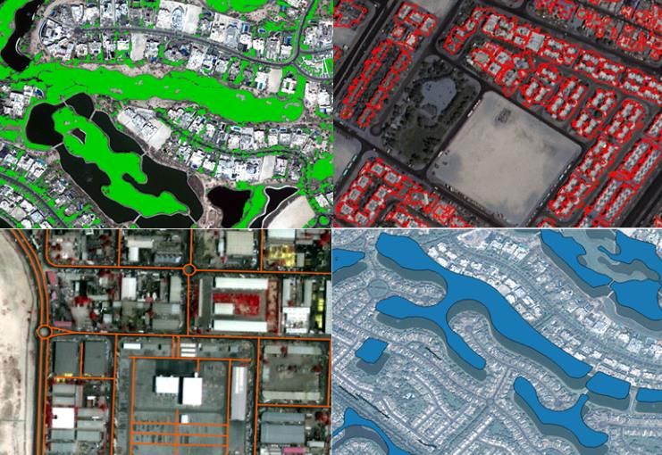
21

BP1: HIGH          RESOLUTION           PLANNING          FOR     TERRITORIAL
PLANNING

DEIMOS Engenharia and Deimos Space UK have developed in the last years a
suite of tools aimed at Use/Land Cover (LULC) Mapping Tool, Feature Extraction
and LULC Change Detection.

These components provide a suite of tools ideal for institutions with territorial
planning responsibilities that have a wide range of LULC mapping needs that can
include generic baseline LULC maps or thematic maps for specific features (e.g
roads, roundabouts) and respective changes. They require the development of
LULC, feature and LULC change maps based on several remote sensing sources,
covering high and very high resolution imagery, and with diverse classification
schemes.

These tools will make available through a web based application where the user
will be able to customize the required steps:
a) define the type of imagery to use;
b) define the classification scheme;
c) use existent or new training data;
d) compare classification algorithms;
e) visualize outputs in map, graph and table forms;
f) edit output to correct classification errors and;
g) rerun the classification.

The application will provide an integrated environment to access these
functionalities with the advantages of accessing the NextGEOSS image catalogue
and processing capabilities. It will be tested for two case studies, Lisbon and
Dubai cities, using high (Landsat and Sentinel-2) and very high (Deimos-2 and
Worldview) satellite imagery.

Geographical Area
Local

Data
The pilot will focus in high resolution imagery datasets such as Landsat and
Sentinel as well as very high satellite sensors such as Deimos-2 and Worldview.
Additionally training data for the classification algorithms will be provided by open
data streams such as the one provided by Openstreet
22

   BP1: HIGH          RESOLUTION          PLANNING         FOR      TERRITORIAL
   PLANNING

   Context

   Satellite based Land Use/Land Cover (LULC) and LULC change maps using satellite
   imagery provides cost effective and dynamic territorial data. Satellite imagery can
   be used to address the different requirements from territorial planning
   institutions, from producing baseline LULC maps at wider scales to detailed maps
   for specific LULC classes (e.g. roads or roundabouts) and calculating the
   respective changes. Implementing the classification methods to achieve this can
   still be very cumbersome for non-remote sensing experts. This pilot aims to
   design an intuitive web based interface that allows users to train, classify and
   analyse satellite based LULC and LULC change maps.

   Target Community

   This pilot will focus in addressing the LULC mapping needs of territorial planning
   institutions. Case studies for the Lisbon and Dubai city regions will be developed,
   following the requirements of relevant decision makers in those areas such as the
   Dubai Road Transport Authority.

   Expected Outcome

   A web based interface to generate customized high (10 to 30 meters) and very
   high resolution (1 to 4 meters) LULC, LULC change and feature detection maps in
   urban environments, covering all the required steps to perform this classification,
   from the training of the classification algorithm to the analysis of the output
   classification and change detection data

Result on CGI
Demonstration products will be
available from the GCI.

           Consortium Partners
                                 VITO
23 BP2: CROP MONITORING SUPPORTING FOOD SECURITY The Copernicus Sentinel-2 mission is an important assess for crop monitoring, making field based monitoring possible. The overall objective of this pilot activity is to demonstrate how NextGEOSS facilitates the use and processing of Sentinel-2 data for Crop Monitoring: • Easy access to the data via the NextGEOSS DataHub • Close monitoring of crops, which needs temporal dense profiles • A processing chain processing Sentinel-2 L1C data to vegetation indices towards crop information will be demonstrated. Also a Web based dashboard will be developed to allow users to explore this information: this will be an extension of the WatchItGrow dashboard https://watchitgrow.be/en, with an extended area of interest including also an African country. Also additional meteo data will be added. • In a second step, phenology will be added, both processing from Sentinel-2 on the NextGEOSS cloud and on the dashboard. • Crop Monitoring products will defined in collaboration with the industry and the GeoGLAM community. • Also the links with the ESA sponsored project TEP Food Security will be explored. To obtain a temporal dense profile, Sentinel-2 alone is not sufficient. Therefore these data will be fused with data from Proba-V (a Copernicus Contributing Mission: proba-v.vgt.vito.be) at 100 m spatial resolution. Geographical Area Pilot regions in Europe (Belgium) and Africa (Senegal) Data Sentinel-2, Proba-V 100 m, meteo data (rainfall, temperature, …)
24

   BP2: CROP MONITORING SUPPORTING FOOD SECURITY

   Context

   To support Food Security and in particular agriculture monitoring, this pilot
   demonstrates how the NextGEOSS platform can unlock the enormous potential of
   high-resolution data (e.g. Sentinel-2), where traditionally crop monitoring was
   done using mainly medium resolution data from various satellite missions and the
   vegetation parameters from Copernicus Global Land.

   Target Community

   In this pilot we will address existing demands from the Agro industry, as well as
   (re-)insurance companies. But as well from organisations as FAO, JRC, and
   others, who show a clear need for these tools. The pilot will be promoted inside
   GEOGLAM who can benefit significantly.

   Expected Outcome

   Vegetation products, including phenology, will be derived on-demand from
   Sentinel-2 on a cloud platform. Here we address current bottlenecks regarding
   access to different sources of EO-data, ranking from medium resolution (but high
   temporal resolution) to high resolution (high spatial resolution), which is
   scattered. Therefore data fusion between Sentinel-2 and Proba-V is addressed as
   well.

Result on GCI
Demonstration products will be available
from the GCI.

              Consortium Partners
                                    VITO
25 BP3: SMART CITIES A lot of public decisions are taken at the level of the city. Smart Cities have not been part of the GEOSS activities, albeit citizens can benefit from derived services. Purpose of this Task is to promote the use of EO in Smart Cities and to bring Smart City sensor reading into GEOSS (mostly in-situ), so that they can be used in combination with other datasets to make derived products, validate, calibrate or qualify other sources of data or build a rapid evaluation assessment of the situation in case of crisis situations. In a sense, Smart City readings can be seen as a parallel to Citizen Science contributions, but having a better ‘quality label’ (coming from an official, authoritative and authenticated source of information). Smart Cities share a lot of GEO Sustainable Development Goals, so they will benefit from the EO data, and better understand how they contribute to the SDG’s. NextGEOSS will map the Smart City KPI (ISO 37120) to the GEO SDG indicators, so that indicator information can be more exchanged. The European Commission funds 10 Smart City Lighthouse projects (with both large and small cities across Europe) with which NextGEOSS will promote the use of Earth Observation information as well as liaise with Smart City associations and consortia. Geographical Area Larger European cities Data Smart Cities typically make time series data available, coming from a sensor installed across the city – or sensors installed on top of moving city vehicles (buses, maintenance trucks). This sensor information is not directly accessible, but are typically stored in ‘data lakes’ – virtual distributed databases. Information is made accessible through interoperable web services.
26

    BP3: SMART CITIES

   Context

    Earth Observation has a big potential in Smart Cities projects – currently Smart
    Cities activities are mostly focused on Internet of Things and existing city
    datasets. By bringing Earth Observation information to Smart City projects, for
    example the Solar Potential Atlas, Smart Cities can inform their citizens on
    alternative energy sources (solar panels or windmills). Other sources include
    weather information, change detection and agriculture information.

    Target Community

    Both citizens and city administration can benefit directly from the EO information.
    In the example of the Solar Potential Atlas, citizens can determine themselves if
    having solar panels is worthwhile. City administration will be able to make better
    informed decisions by including EO information, a data source that is largely
    unknown to city administrations.

    Expected Outcome

    The pilots will promote the use of Earth Observation data/information in Smart
    City projects, but also reverse, promote the use of Smart City sensor information
    of Smart City datasets in the Earth Observation community. Additionally,
    NextGEOSS will map the Smart City KPI (ISO 37120) to the GEO SDG indicators,
    so that indicator information can be more exchanged.

Result on GCI
The resulting information products
will be made available in the GCI
(GEOSS)

         Consortium Partners
                              OGCE
27 BP4: CONSTRUCTING GRIDDED DATA FOR GRID OPERATORS Satellite images are routinely processed to yield information on clouds properties. The Copernicus Atmosphere Monitoring Service (CAMS) offer access to properties of the cloudless atmosphere every 3h. These sets of information are combined together with site-specific properties, e.g. elevation and shadowing by local relief, to produce estimates of the solar radiation at a given site. Thus, the computation is made on an ad hoc basis on-the-fly. To better account for changes in solar position and possible shadowing effects, computations of the solar radiation are made every 1 min and the results are then aggregated e.g. every 15 min or 1 h at the will at the user. The operations are currently working satisfactorily though improvements should be brought to ease access to data by users. A new use case has arisen recently due to the large penetration of PV plants in Europe. Grid operators need a better knowledge of the very local production of electricity by PV plants that are connected to the grid in order to ensure the stability and quality of the electricity delivered to customers. Accordingly, their requests are for time-series of solar radiation over a regular grid of points covering their area of interest which may be nation-wide. Though the time-series may be short, e.g. two days of estimates every 15 min, the number of grid nodes may be high. An area of say 1000 km x 1000 km with a grid cell of 10 km in size means running the model for 10 000 nodes at the same time. The concept of cloud computing supporting the NexGEOSS infrastructure may help in solving this issue in both computational aspects and dissemination aspects. Geographical Area Geographical coverage of the CAMS radiation product: field-of-view of the Meteosat satellite, roughly speaking Europe, Africa, Atlantic Ocean, Middle East (- 66° to 66° in both latitudes and longitudes) Data CAMS (Copernicus Atmosphere Monitoring Service) Radiation product from a one year time period including the following parameters (Atmosphere optical properties, Ground reflectance, Cloud optical properties, Atmosphere radiative transfer).
28

   BP4: CONSTRUCTING GRIDDED DATA FOR GRID OPERATORS

   Context

   Grid operators need a better knowledge of the very local production of electricity
   by PV plants that are connected to the grid in order to ensure the stability and
   quality of the electricity delivered to customers. Their requests are for time-series
   of solar radiation over a regular grid of points covering their area of interest which
   may be nation-wide. The Copernicus Atmosphere Monitoring Service (CAMS) offer
   access to properties of the cloudless atmosphere every 3 h. The operations are
   currently working satisfactorily for single point time series. The NextGEOSS cloud
   based solution is expected to reduce computation time from 15 s per one single
   point to enable real time computation over 1000 km x 1000 km area of 10 km
   grid cells (10 000 cells at the same time).

   Target Community

   Grid operators that need to ensure the stability and quality of the electricity
   delivered to customers. Electricité De France (EDF) is our prime user. In course of
   the projects we will also contact grid operators in Germany with the help of
   research institutions namely University of Ulm und IWES (Fraunhofer-Institut für
   Windenergie und Energiesystemtechnik IWES). companies. But as well from
   organisations as FAO, JRC, and others, who show a clear need for these tools. The
   pilot will be promoted inside GEOGLAM who can benefit significantly.

   Expected Outcome

   A WPS (Web Processing Service) providing access to gridded forms of solar
   radiation based information requested by users.

Result on GCI
Demonstration products will be
available from the GCI.

         Consortium Partners
                          ARMINES
29 BP4: HIGH RESOLUTION SOLAR MAPPING AT URBAN SCALE Solar resource assessment and mapping at the urban scale (metric and sub- metric) is crucial for the developments of PV and solar thermal systems in urban areas. This very high resolution solar resource assessment and mapping require: • high quality long term and high temporal resolution (1-min) solar resource dataset • high quality and high spatial resolution (sub-metric) 3D description of the complex geometry of the urban areas for the shadow (and potentially the multi- refractive effects). The main bottleneck of the high spatial resolution solar resource processing at urban scale resides in the handling of the very huge amount of sub-metric 3D data to process the corresponding local shadow masks for each sub-metric pixel of the solar maps. This local shadow mask is then applied to the high temporal corresponding solar datasets before its multi-annual averaging to provide multi- annual averages of monthly and yearly irradiations. A possible solution would be to resort to cloud computing for the shadow masks determination and the corresponding solar processing on dedicated parallel servers located as close as possible to 3D data sources, to prevent to transmit through the network, this huge amount of information. The concept of cloud computing supporting the NexGEOSS infrastructure may help in solving this issue in both computational aspects and dissemination aspects. Geographical Area Pilot regions in a French city and suburb. Data CAMS (Copernicus Atmosphere Monitoring Service) Radiation product from a one year time period including the following parameters (Atmosphere optical properties, Ground reflectance, Cloud optical properties, Atmosphere radiative transfer). Additionally for the same time period and for a given AOI (Area Of Interest) complementary datasets will be made available including 30 m Digital Terrain Model (SRTM) and 10 cm resolution Digital Surface Model (DSM) of urban area (IGN). All the above resource will be freely available except for the DSM that is Copyrighted (IGN) and access restricted.
30

   BP4: HIGH RESOLUTION SOLAR MAPPING AT URBAN SCALE

   Context

   In the context of the undergoing and future wave of urban demographic growth,
   the development of PV and solar thermal systems in urban areas is of very
   interest since these renewable-based energy systems do not emit pollution or
   GHG and produce energy as close as possible of its consumption. Solar resource
   assessment and mapping at the urban scale (metric and sub-metric) will be then
   crucial for the developments of PV and solar thermal systems in these urban
   areas.

   Target Community

   SMEs in Europe in the business of PV solar potential assessment at urban scale.
   The French SME InSunWeTrust is our prime user.

   Expected Outcome

   A WebGIS client application triggering a WPS (Web Processing Service) for
   providing access to geo-localized patches containing a time-serie of global
   irradiation on tilted plan integrating shadow effects. Output type can be raster or
   vector format or both. Possibly generate an animation of time span and download
   results files.

Result on GCI
Demonstration products will be
available from the GCI.

          Consortium Partners
                            ARMINES
www.nextgeoss.eu · info@nextgeoss.eu
32You can also read