Ryewater Arterial Drainage Scheme 2021 - Natura Impact Statement
←
→
Page content transcription
If your browser does not render page correctly, please read the page content below
Ryewater Arterial
Drainage Scheme
2021

Natura Impact Statement
April 2021

www.jbaconsulting.ie

Office of Public Works
Templemungret House
Mungret
Co. Limerick

DJF-JBAI-XX-XX-RP-BD-0009-A3_C01_Ryewater_NIS   i
JBA Project Manager
Tom Sampson
24 Grove Island
Corbally
Limerick
Ireland

Revision History
 Revision Ref/Date                         Amendments                              Issued to
 07 December 2020                          Draft Report                            Fergal Kelly, OPW
 22 April 2021                             Final Report                            Fergal Kelly, OPW

Contract
This report describes work commissioned by the Office of Public Works, by a letter dated
17/04/2020. The Office of Public Works' representative for the contract was Fergal Kelly.
Steven Heathcote, Sarah King and Carly Benefer of JBA Consulting carried out this work.

Prepared by ..................................         Dr Steven Heathcote BA(Hons) DPhil MCIEEM

                                                       Senior Ecologist

....................................................   Sarah King BSc MSc MCIEEM

                                                       Ecologist

Reviewed by .................................          Laura Thomas BA MRes PGCert CEcol MCIEEM

                                                       Principal Ecologist

Purpose
This document has been prepared as a Final Report for the Office for Public Works. JBA
Consulting accepts no responsibility or liability for any use that is made of this document
other than by the Client for the purposes for which it was originally commissioned and
prepared.
JBA Consulting has no liability regarding the use of this report except to the Office for
Public Works.

Copyright
© JBA Consulting Engineers and Scientists Limited 2021.

Carbon Footprint
A printed copy of the main text in this document will result in a carbon footprint of 58g if
100% post-consumer recycled paper is used and 73g if primary-source paper is used.
These figures assume the report is printed in black and white on A4 paper and in duplex.
JBA is aiming to reduce its per capita carbon emissions.

DJF-JBAI-XX-XX-RP-BD-0009-A3_C01_Ryewater_NIS                                                          i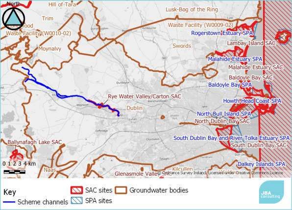
Executive summary
This assessment is in relation to statutory arterial drainage maintenance activities on
the Ryewater Arterial Drainage Scheme. The Ryewater Arterial Drainage Scheme is
an Office for Public Works scheme covering areas of Co. Meath and Kildare. The
Arterial Drainage Scheme is the implementation of the legal duty under the Arterial
Drainage Acts of 1945 and 1995 to maintain channels and embankments involved in
the land drainage of these areas. This report presents an assessment of the works in
line with requirements of The Habitats Directive (Directive 92/43/EEC).
The project involves a range of standard maintenance activities, including in-channel
and embankment vegetation management, silt removal and tree works. These are all
carried out following detailed environmental procedures (EPs) contained in Brew &
Gilligan (2019) which set out the minimum environmental and ecological standards
that works should follow.
A combination of desk-based assessments and field survey work were used to
identify the baseline ecological conditions on and adjacent to the scheme channels.
The surveys identified one Annex I habitat adjacent to scheme channels, and
suitable habitat for Annex II species.
The project zone of influence was determined using the Ryan Hanley screening
method (Ryan Hanley, 2014a), prepared specifically for arterial drainage schemes.
This uses variable distances depending on pathways of impact. A single Natura 2000
sites was present within the zone of influence, Rye Water / Carton Special Area of
Conservation (SAC). The screening process considered impact pathways via surface
water, land and air, and groundwater. The screening process identified that the
scheme could have impacts on the SAC which required an Appropriate Assessment.
A detailed assessment of impacts was carried out following the Ryan Hanley Source-
Receptor-Pathway approach developed for arterial drainage schemes. Consideration
of the project highlighted potential impacts requiring additional mitigation. Most of
the mitigation is contained within the additional environmental procedures which are
not implemented as standard. A small number of additional avoidance and mitigation
measures are included.
An in-combination assessment was completed looking at relevant plans and projects.
No in-combination impacts were identified which would require further avoidance or
mitigation.
The NIS has concluded that, given the avoidance and mitigation measures
suggested, the proposed drainage maintenance operations in the Ryewater Arterial
Drainage Scheme will not have a significant adverse impact on any Natura 2000
sites.

DJF-JBAI-XX-XX-RP-BD-0009-A3_C01_Ryewater_NIS                                             ii
Contents
1        Introduction                                             1
1.1      Background                                               1
1.2      Legislative Context                                      1
1.3      Appropriate Assessment Process                           1
1.4      Structure of this report                                 3
2        Methodology                                              4
2.1      Desktop Survey                                           4
2.2      Ecological Surveys                                       5
2.3      Screening Method                                         6
2.4      Impact Assessment Method                                 6
2.5      In-combination Assessment                                7
2.6      Consultation                                             8
2.7      Competent Persons                                        8
2.8      Limitations and Constraints                              8
3        Project Description                                      9
3.1      The ‘Project’                                            9
3.2      Project Location                                         9
3.3      Description of Project Activities                       10
3.4      Project Zone of Influence                               17
4        Ecology Baseline                                        18
4.1      Overview                                                18
4.2      Habitats                                                18
4.3      Protected Flora and Fauna                               20
4.4      Invasive Species                                        23
5        Screening Assessment                                    26
5.1      Surface Water Pathways                                  26
5.2      Land and air pathways                                   28
5.3      Groundwater pathways                                    29
5.4      Screening assessment conclusion                         33
6        Natura 2000 Sites                                       35
6.1      Rye Water Valley/Carton SAC                             35
7        Stage 2 Appropriate Assessment                          38
7.1      Introduction                                            38
7.2      Identification of Potential Sources of Impact           38
7.3      Impact Assessment                                       39
7.4      Impact Evaluation                                       40
7.5      Avoidance and Mitigation Measures                       44
7.6      Site specific mitigation measures                       44
8        Other Relevant Plans and Projects                       46
8.1      Cumulative effects                                      46
8.2      Plans                                                   46
8.3      Projects                                                48
8.4      Agricultural activities in the Ryewater catchment       50
8.5      Significance of cumulative and in-combination impacts   50
9        Conclusion                                              52
9.1      Potential Impacts                                       52
9.2      Cumulative Impacts                                      52
9.3      Mitigation Measures                                     52
9.4      Summary                                                 52

DJF-JBAI-XX-XX-RP-BD-0009-A3_C01_Ryewater_NIS                         iii
References                                                                       LVIII

List of Figures
Figure   1-1: The Appropriate Assessment Process                                          2
Figure   2-1: 10 km grid search area for NPWS species records                             5
Figure   3-1 Location of Ryewater Arterial Drainage Scheme                                9
Figure   4-1: Location of petrifying spring habitat noted in 2018 (from JBA 2016b)       19
Figure   5-1: Surface water catchments for the Ryewater Scheme                           27
Figure   5-2: Groundwater bodies for the Ryewater scheme                                 30
Figure   6-1. Natura 2000 sites screened in for Appropriate Assessment                   35

List of Tables
Table 3-1. Channel maintenance details                                                   10
Table 3-2: OPW Drainage Maintenance Subcategories                                        10
Table 3-3: Drainage Maintenance Procedures and whether these are a description of
the project, or mitigation measures                                                      12
Table 4-1: Annex 1 habitats recorded along Rye Water Scheme                              18
Table 4-2: Protected species recorded near the scheme channels                           20
Table 4-3: Invasive species recorded near the scheme channels                            23
Table 5-1: Surface Water Pathways                                                        26
Table 5-2: WFD Risk Status of Surface Water Bodies within 5km                            27
Table 5-3: Summary results of SWD QIs of SACs with potential surface water
pathways, potential Annex I habitats present and potential for significant impact        28
Table 5-4: Land and air pathways                                                         28
Table 5-5: Summary results of QIs / FOIs with potential land and air connectivity        29
Table 5-6: Natura 2000 sites with potential to be impacted by groundwater pathways       30
Table 5-7: Natura 2000 sites with potential to be impacted by groundwater pathways       30
Table 5-8: Risk status for GWBs                                                          31
Table 5-9: Assessment of potential impacts based on location                             31
Table 5-10. Potential pressures and threats for the screened in Natura 2000 site         31
Table 5-11. Groundwater Pathway - Step 7 for SAC Rye Water Valley/Carton SAC
(001398)                                                                                 32
Table 5-12 Conclusions of screening assessment for likelihood of significant effect      34
Table 6-1 Threats and Pressures posed to Rye Water Valley/Carton SAC (NPWS
2017b)                                                                                   36
Table 6-2: Condition indicators for Petrifying Springs                                   37
Table 6-3. Proposed conservation Objectives for Annex II snails                          37
Table 7-1 Impact evaluation table for screened in QI/SCI and pathways                    41
Table 7-2. Specific mitigation measures                                                  44
Table 8-1: Rye Water Valley/Carton SAC: Projects granted or pending planning
permission with potential to result in in-combination effects                            48
Table 8-2 In-combination assessment details                                              50
Table 9-1: Integrity of Site Checklist- Conservation Objectives (from DoEHLG, 2009)      53
Table 9-2: Integrity of Site Checklist- Other Objectives (from DoEHLG, 2009)             53

DJF-JBAI-XX-XX-RP-BD-0009-A3_C01_Ryewater_NIS                                             iv

Abbreviations
AA                   Appropriate Assessment
CA                   Competent Authority
CIEEM                Chartered Institute of Ecology and Environmental Management
CL                   Conservation Limit
CO                   Conservation Objectives
DoEHLG               Department of the Environment, Heritage and Local Government
EC                   European Community
EP                   Environmental Procedures
EPA                  Environmental Protection Agency
FCS                  Favourable Conservation Status
FRS                  Flood Relief Scheme
GIS                  Geographical Information System
GWD                  Ground Water Dependant
HDPE                 High-density polyethylene
IFI                  Inland Fisheries Ireland
IROPI                Imperative Reasons of Overriding Public Interest
IUCN                 International Union for Conservation of Nature
I-WeBS               Irish Wetland Bird Survey
LHB                  Lesser-horseshoe Bat
MAC                  Maintenance Access Corridors
NHA                  Natural Heritage Area
NIS                  Natura Impact Statement
NBDC                 National Biodiversity Data Centre
NNIS                 Non-Native Invasive Species
NPWS                 National Parks and Wildlife Services
NRA                  National Roads Authority
OPW                  Office of Public Works
pNHA                 Proposed Natural Heritage Area
RBMP                 River Basin Management Plan
SAC                  Special Area of Conservation
SPA                  Special Protection Area
SWD                  Surface Water Dependant
QI                   Qualifying Interests
WFD                  Water Framework Directive
WWTP                 Waste Water Treatment Plant
ZOI                  Zone of Influence

DJF-JBAI-XX-XX-RP-BD-0009-A3_C01_Ryewater_NIS                                       v
1 Introduction

   1.1   Background
         JBA Consulting has been appointed by the Office of Public Works (OPW), to
         undertake Environmental Consultancy services in relation to statutory arterial
         drainage maintenance activities for 2021-2026 on the Ryewater Arterial
         Drainage Scheme. This includes providing information for the competent
         authority to assist them to undertake an Appropriate Assessment of the effects
         of the project on Natura 2000 sites.
         The proposed project is part of the maintenance of the Ryewater Arterial
         Drainage Scheme, required as part of maintenance activities under the Arterial
         Drainage Acts of 1945 and 1995, and includes the Rye Water and associated
         drainage channels on the County Meath/Kildare boundary.
         The Zone of Influence within which potential impacts from any proposed project
         must be considered for significance, depends on a variety of factors. This
         includes the nature, location and extent of the proposed works, the ecological
         receptors present within the Natura 2000 sites within the area and the potential
         for in-combination impacts (DEHLG 2009).
         One Natura 2000 site was identified as occurring within the broad Zone of
         Influence of the proposed works. This Natura Impact Statement (NIS) provides
         the results of the appraisal conducted for the Ryewater Arterial Drainage
         Scheme in accordance with Article 6(3) of the Habitats Directive (Council
         Directive 92/43/EEC on the conservation of natural habitats and of wild fauna
         and flora).

   1.2   Legislative Context
         The Habitats Directive (Directive 92/43/EEC) aims to maintain or restore the
         favourable conservation status of habitats and species of community interest
         across Europe. The requirements of Articles 6(3) and 6(4) of the Habitats
         Directive have been transposed into Irish legislation by means of the Habitats
         Regulations, 1997 (S.I. No. 94 of 1997) and the European Communities (Birds
         and Natural Habitats) Regulations 2011 (S.I. No. 477 of 2011).
         Under the Directive a network of sites of nature conservation importance have
         been identified by each Member State as containing specified habitats or species
         requiring to be maintained or returned to favourable conservation status. In
         Ireland the network consists of Special Areas of Conservation (SACs) and
         Special Protection Areas (SPAs), and also candidate sites, which together form
         the Natura 2000 network.
         Article 6(3) of the Habitats Directive requires that, in relation to European
         designated sites (i.e. SACs and SPAs that form the Natura 2000 network), "any
         plan or project not directly connected with or necessary to the management of
         the site but likely to have a significant effect thereon, either individually or in
         combination with other plans or projects, shall be subject to appropriate
         assessment of its implications for the site in view of the site's conservation
         objectives".
         A competent authority (e.g. Local Authority) can only agree to a plan or project
         after having determined that it will not adversely affect the integrity of the site
         concerned.

   1.3   Appropriate Assessment Process
         Guidance on the Appropriate Assessment (AA) process was produced by the
         European Commission in 2002, which was subsequently developed into guidance
         specifically for Ireland by the Department of Environment, Heritage and Local

DJF-JBAI-XX-XX-RP-BD-0009-A3_C01_Ryewater_NIS                                                  1
Government (DoEHLG) (2009 rev 2010). These guidance documents identify a
staged approach to conducting an AA, as shown in Figure 1-1.
Stage 1 Stage 3
Stage 2 Stage 4
Screening Alternative
AA IROPI
for AA Solutions
Figure 1-1: The Appropriate Assessment Process
1.3.1 Stage 1 - Screening for AA
The initial, screening stage of the Appropriate Assessment is to determine:
a) whether the proposed plan or project is directly connected with, or
necessary for, the management of the European designated site for
nature conservation
b) if it is likely to have a significant adverse effect on the European
designated site, either individually or in combination with other plans or
projects
For those sites where potential adverse impacts are identified, either alone or in
combination with other plans or projects, further assessment is necessary to
determine if the proposals will have an adverse impact on the integrity of a
European designated site, taking into account the sites conservation objectives
(i.e. the process proceeds to Stage 2).
1.3.2 Stage 2 - AA
This stage requires a more in-depth evaluation of the plan or project, and the
potential direct and indirect impacts arising from it on the integrity and the
interest features of the European designated site(s), alone and in-combination
with other plans and projects, taking into account the site's structure, function
and conservation objectives. Where required, mitigation or avoidance measures
will be suggested.
The competent authority can only agree to the plan or project after having
ascertained that it will not adversely affect the integrity of the site(s) concerned.
If this cannot be determined, and where mitigation cannot be achieved, then
alternative solutions will need to be considered (i.e. the process proceeds to
Stage 3).
1.3.3 Stage 3 - Alternative Solutions
Where adverse impacts on the integrity of Natura 2000 sites are identified, and
mitigation cannot be satisfactorily implemented, alternative ways of achieving
the objectives of the plan or project that avoid adverse impacts need to be
considered. If none can be found, the process proceeds to Stage 4.
1.3.4 Stage 4 - IROPI
Where adverse impacts of a plan or project on the integrity of Natura 2000 sites
are identified and no alternative solutions exist, the plan will only be allowed to
progress if imperative reasons of overriding public interest (IROPI) can be
demonstrated. In this case compensatory measures will be required.
The process only proceeds through each of the four stages for certain plans or
projects. For example, for a plan or project, not connected with management of
a site, but where no likely significant impacts are identified, the process stops at
DJF-JBAI-XX-XX-RP-BD-0009-A3_C01_Ryewater_NIS 2stage 1. Throughout the process, the precautionary principle must be applied,
so that any uncertainties do not result in adverse impacts on a site.
1.4 Structure of this report
In order to provide the competent authority with the relevant information to
determine with confidence their conclusions on the overall impacts of the project
to the integrity of the sites concerned, this NIS presents the following:
• Section 2: Details of the methods used in this assessment.
• Section 3: A detailed description of the proposed project.
• Section 4: A detailed description of the baseline conditions within the
area of works.
• Section 5: A screening of Natura 2000 sites based on those that are
located within the Zone of Influence (ZOI) of the proposed works.
• Section 6: A description of those Natura 2000 sites that are screened in
for being at risk for potential adverse impacts from the proposed works.
• Section 7: Identification of potential sources of impact to the screened in
Natura 2000 sites and assessment of the impacts for significance. Where
effects are present specific mitigation is proposed.
• Section 8: Assessment of cumulative and/or in-combination impacts
where non-significant effects are present.
• Section 9: Summary of the impacts and mitigation with overall
assessment on the coherence of the Natura 2000 network.
DJF-JBAI-XX-XX-RP-BD-0009-A3_C01_Ryewater_NIS 32 Methodology
This NIS has been prepared in compliance with the following documents:
• DEHLG (2009) Appropriate Assessment of Plans and Projects in Ireland
Guidance for Planning Authorities. Department of the Environment,
Heritage and Local Government. Revised 2010.
• European Commission (EC) (2019) Managing Natura 2000 Sites: the
provisions of Article 6 of the ‘Habitats’ Directive 92/43/EEC, Office for
Official Publications of the European Communities, Luxembourg.
European Commission.
• EC (2002) Assessment of Plans and Projects Significantly Affecting
Natura 2000 Sites: Methodological guidance on the provisions of
Article 6(3) and (4) of the Habitats Directive 92/43/EEC, Office for
Official Publications of the European Communities, Luxembourg.
European Commission.
• EC (2013) Interpretation Manual of European Union Habitats. Version
EUR 28. European Commission.
• Fossitt, J. (2000). A Guide to Habitats in Ireland. The Heritage Council,
Kilkenny.
• Guidelines for Ecological Impact Assessment in the UK and Ireland -
Terrestrial, Freshwater and Coastal, Second Ed. (Chartered Institute of
Ecology and Environmental Management, 2018)
2.1 Desktop Survey
A desktop survey was conducted of available published and unpublished
information, along with a review of data available on the National Parks and
Wildlife Service (NPWS) and National Biodiversity Data Centre (NBDC) web-
based databases, in order to identify key habitats and species (included legally
protected and species of conservation concern) that may be present within
ecologically relevant distances from the scheme as explained below. The data
sources below were consulted for the desktop study:
• NBDC species data within the four 10 km grid squares which include
scheme channels, within the past 10 years (Figure 2-1).
• NPWS website (www.npws.ie), (https://www.npws.ie/), where site
synopses, Natura 2000 data forms and conservation objectives were
obtained along with Annex 1 habitat distribution data and status
reports.
• NBDC Maps (http://maps.biodiversityireland.ie/#/Map)
• NPWS (2019a). The Status of EU Protected Habitats and Species in
Ireland. Volume 1: Summary Overview. Unpublished NPWS report.
• NPWS (2019b). The Status of EU Protected Habitats and Species in
Ireland. Volume 2: Habitat Assessments. Unpublished NPWS report.
• NPWS (2019c). The Status of EU Protected Habitats and Species in
Ireland. Volume 3: Species Assessments. Unpublished NPWS report.
• Environmental Protection Agency (EPA) maps website
(https://gis.epa.ie/EPAMaps/)
• Water Maps (www.watermaps.wfdireland.ie)
• BirdLife International (www.birdlife.org)
• BirdWatch Ireland (www.birdwatchireland.ie)
DJF-JBAI-XX-XX-RP-BD-0009-A3_C01_Ryewater_NIS 4• County Meath Development Plan
(http://countydevelopmentplan.meath.ie/adoptedplan/)
• Kildare County Development Plan
(http://kildare.ie/CountyCouncil/AllServices/Planning/DevelopmentPlan
s/KildareCountyDevelopmentPlan2017-2023/)
• Bird survey data from the waterbird survey programme and the Irish
Wetland Bird Survey (I-WeBS)
• Review of older surveys including the screening assessment for the
Appropriate Assessment 2015 and NIS for the previous 5-year
maintenance work 2016-2020 (JBA 2015, 2016a, 2016b).
Figure 2-1: 10 km grid search area for NPWS species records
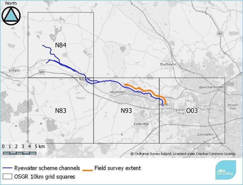
2.2 Ecological Surveys
To inform this NIS for the Arterial Drainage Maintenance programme, ecological
surveys were carried out by JBA ecologists Malin Lundberg BSc MSc and William
Mulville BSc MSc on the 16th September 2020 and 22nd October 2020. The
scope of the surveys was to survey priority channels identified by the OPW for
upcoming works, those habitats that may have changed since the previous
surveys e.g. mosaic habitats, or those ecologically sensitive habitats that may
be present e.g. tufa formations. The extent of the field survey is shown in Figure
2-1.
The ecological walkover survey was carried out in general accordance with the
methods outlined in the following documents:
• Heritage Council’s best practice guidance for habitat survey and
mapping (Smith et al., 2011).
• Ecological Surveying Techniques for Protected Flora and Fauna during
the Planning of National Road Schemes (NRA, 2009).
DJF-JBAI-XX-XX-RP-BD-0009-A3_C01_Ryewater_NIS 5• A Guide to Habitats in Ireland. The Heritage Council, Kilkenny (Fossitt,
2000).
Protected species, including mammals (e.g. Otter, Badger) and birds, were
surveyed based upon sightings and signs of activity during the habitat survey
and also by the identification of potentially suitable habitats. This included a
preliminary assessment of features with suitability for roosting bats and
recording of any non-native invasive species found.
Habitats were surveyed following standard methodology (Smith et al., 2011)
and were classified, where applicable, according to The Interpretation Manual of
European Union Habitats (European Communities, 2013). Habitats were also
considered under the national habitat classification system of Fossitt (2000), as
only some of the habitats at the site are listed on Annex I of the Habitats
Directive. Nomenclature for higher plants principally follows Parnell and Curtis
(2012).
All evidence of protected habitats and species was recorded on a tablet using
the bespoke JBA GISmapp application by JBA Ecologists where relevant. All
information gathered was collated and provided to the OPW on a separate GIS
database.
2.3 Screening Method
The screening method follows closely the method developed to screen impacts
of Arterial Drainage Schemes by Ryan Hanley (2014a). This involves a careful
consideration of the impacts likely via the pathways discussed in Section 2.4.
The screening method has been updated to take into account environmental
procedures (EP) which are considered part of the project description, that is
they will be implemented regardless of setting and there is high confidence in
their effectiveness. Some EPs are implemented only in specific locations, so
these are not considered part of the project description. In particular the
impacts of the implementation EP7 and EP10, which are always completed
prevent impacts related to poor-practice for vegetation and silt management
respectively.
2.4 Impact Assessment Method
The assessment used the source-pathway-receptor model which is a
conventional model used for determining the risk of impact to a site or
qualifying interest (CIEEM 2018). For Arterial Drainage Schemes this is
implemented using the guidance provided by Ryan Hanley (2014b) which is
developed to examine the specific impacts related to the Arterial Drainage
Schemes.
Risk is the likelihood or expected frequency of a specified adverse consequence
or impact. Applied to the Habitats Directive and the Arterial Drainage
Maintenance programme, it expresses the likelihood of an adverse impact
arising as a result of the proposed works and associated activities. The proposed
works or activities that may occur as a result of the Arterial Drainage
Maintenance programme can be considered a potential hazard. A hazard
presents a risk when it is likely to affect something of value (i.e. the Natura
2000 sites and their QIs). It is the combination of the probability of the hazard
of occurring and its consequences that is the basis of a risk assessment which
an NIS essentially is:
Risk = probability of an event x consequential damage
The source-pathway-receptor model is a useful tool for determine if a risk is
present. In order for a risk to be present, all three elements must be present.
Source: The source considered in this NIS, is the proposed works or activity
that will occur as a result of the Arterial Drainage Maintenance programme. Key
DJF-JBAI-XX-XX-RP-BD-0009-A3_C01_Ryewater_NIS 6considerations in assessing the source are the nature and scale of the potential
impacts that may arise such as the type of contaminants that may arise, the
contaminant loading and other physical attributes. The point of occurrence is a
critical reference point for assessing the attributes of the Source of any potential
adverse impacts.
Pathway: Pathways are established by surface water, groundwater and land
and air connections. The pathway includes everything between the source and
the receptor; from point of release of potential adverse impacts, such as
contaminants, to the receptor. The location, nature, connectivity and extent of
wells, groundwater dependent ecosystems, aquifers and faults can all influence
the nature of a pathway. Rivers, streams and drainage ditches could all act as
potential pathways for potential water borne impacts. Land and air pathways to
be considered include those that may transfer direct physical impacts, noise and
visual disturbance (vibrations) and dust or other airborne particles.
Receptor: The receptor is the qualifying interests of the relevant Natura 2000
sites, their COs and the overall integrity of the Natura 2000 sites. While the
competent authority should only agree to the plan or project after having
ascertained that it will not adversely affect the integrity of the site concerned. In
order to determine the significance of any potential adverse impacts that may
occur that may adversely affect the integrity of the Natura 2000 site, the COs of
each site are assessed relative to the potential impacts that may occur as a
result of the proposed works. Each Natura 2000 site will either have specific or
generic conservation objectives. Detailed site-specific conservation objectives
have been provided for some of SACs and SPAs, which can be found within the
CO document for each site on the NPWS website and Appendix A. Generic
conservation objectives have been compiled for the remaining SACs and SPA
which is further explained in Section 2.8.
The overall aim of conservation objectives is to maintain or restore the
favourable conservation conditions of the Annex I habitats and/or the Annex II
species for which a SAC has been selected, under which the site-specific
objectives contain more detailed attributes, measures and targets. There are a
set of generic conservation objectives for species and habitats. For some sites
these have been developed into site-specific objectives.
In order to ensure that any recommended mitigation measures are sufficient
and likely to be successful, they are designed in accordance with the most up to
date best practise guidelines and tailored where necessary to the conditions on-
site and nature of the relevant receptors. The OPW provides staff with on-going
environmental training in the identification of receptors and pathways, as well as
in the implementation of mitigation measures, the environmental procedures
and through these a reduction of potential impacts from their work. The most
recent structured training programme was provided in 2018, however, through
a yearly audit programme with external consultants and staff, up to 50 toolbox
talks are given on-site by experienced ecologists to staff throughout the year. In
this way OPW staff receive specific training relative to their work, on-site during
their work.
2.5 In-combination Assessment
The in-combination assessment method was based on searching for plans and
projects where the Ryewater Arterial Drainage Scheme had non-significant
residual impacts. Where these impacts were identified, the relevant screening
distance for the impact pathway from Ryan Hanley (2014a) was applied to
Natura 2000 site. Within this screening distance any plans and projects were
searched for. If the plan or project had a published NIS which was not subject to
a further information request, this was reviewed for possible in-combination
impacts. If this NIS concluded no impacts (including no non-significant residual
DJF-JBAI-XX-XX-RP-BD-0009-A3_C01_Ryewater_NIS 7impacts) alone, the plan or project was ruled out of the in-combination
assessment, and this is noted in the text. If the NIS included potential residual
impacts, or if it was subject to a further information request, then it was taken
forward for impact assessment in-combination with the arterial drainage
scheme.
2.6 Consultation
The findings of this assessment will be subject to consultation with the NPWS as
the statutory nature conservation body. In support of this document a NPWS
sensitive data request was carried out by JBA Consulting.
2.7 Competent Persons
The assessment has been carried out by JBA ecologists Dr Steven Heathcote
BA(Hons) DPhil MCIEEM and Sarah King BSc MSc MCIEEM. Both Dr Steven
Heathcote and Sarah King have undertaken numerous Appropriate Assessment
reports and NIS assessments for a variety of schemes in Ireland as well as
assessment of projects under Article 6 of the Habitats Directive in a range of
European countries over the past 10 years. The assessment has been reviewed
by Laura Thomas BA(Hons) MRes PGCert CEcol MCIEEM, a Principal Ecologist
with over 15 years' consultancy experience in undertaking assessments under
the Habitats Directive.
2.8 Limitations and Constraints
The conclusion of this report necessarily relies on some assumptions and it is
inevitably subject to some limitations. Most of the assumptions and limitations
would not affect the conclusion but the following points are recorded to ensure
the basis of the assessment is clear:
• Some Natura 2000 sites do not have detailed COs instead using a set
of generic objectives. For these sites, including the Rye Water / Carton
SAC, the COs have been derived from other nearby Natura 2000 sites
with the same QIs or from specific guidance documents for these
habitats or species. In these cases, the necessary assumption has
been made that the sites have similar characteristics.
• Field data is available from a selection of the scheme channels and it
was not practical or feasible to walk all channels. The Rye Water Valley
/ Carton SAC has been extensively studied, and the surveys focused
on the most sensitive areas with the designated habitats/ species
present. This is therefore unlikely to significantly alter the assessment.
• Adverse weather can cause delays to the schedule and alter the timing
of works. This has been accounted for using a worst-case scenario
where necessary, but some seasonal restrictions cannot be varied
without resulting in significant impacts and these are made clear in the
assessment.
• In all instances where constraints or limitations may impact the result
the impact of the NIS, the precautionary principle is used.
DJF-JBAI-XX-XX-RP-BD-0009-A3_C01_Ryewater_NIS 83 Project Description
3.1 The ‘Project’
The proposed Ryewater Arterial Drainage Maintenance meets the criteria of a
'Project' as defined in the Habitats Directive and is not directly connected with or
necessary to the management of any Natura 2000 site. Therefore, the project is
subject to the requirements of the Appropriate Assessment process.
The OPW is statutorily obligated to maintain arterial drainage channels under
the 1945 Arterial Drainage Act, and since their completion, maintenance of
these Arterial Drainage Schemes has been ongoing. Channels are typically
maintained annually, bi-annually or every five or ten years and the
environmental impacts are reviewed every five years. Amendments to the Act in
1995 included the requirement to maintain Flood Relief Schemes implemented
under the Arterial Drainage Acts.
3.2 Project Location
The Ryewater Drainage Scheme is located on the County Meath/Kildare border.
It includes 32km of watercourse (Figure 3-1), 9km of which flow through an
SAC, with 344 hectares of benefiting land. The watercourse is the Ryewater and
it discharges into the River Liffey at Leixlip, downstream of the Louisa Bridge.
The majority of the channels in the Ryewater Drainage Scheme are maintained
every five years.
Figure 3-1 Location of Ryewater Arterial Drainage Scheme
DJF-JBAI-XX-XX-RP-BD-0009-A3_C01_Ryewater_NIS 93.3 Description of Project Activities
3.3.1 Ryewater maintenance programme
Drainage Maintenance includes a range of operations such as silt and vegetation
management, mowing and structure maintenance, as listed as channel,
embankment or structure maintenance in Table 3-2 below. It is required to
retain the arterial drainage scheme design capacity.
Table 3-1. Channel maintenance details
Channel Ref Freq. Timing Machine Activity Length
and chainage (yrs) Type (km)
A B C D E
Summer
C1 Sect. A
10 (D/E Long-reach ✓ ✓ ✓ 22.1
(0-1900ch)
winter)
C1 Sect. B Summer
(1900- 10 (D/E - ✓ 2.1
4000ch) winter)
C1 Sect C Summer
(4000- 10 (D/E Long-reach ✓ ✓ ✓ 22.1
14500ch) winter)
C1 Sect D
(14500- 4 Summer Short-reach ✓ ✓ ✓ 22.1
24175ch)
C1/1 4 Any Short-reach ✓ ✓ 2.0
C1/2 4 Any Short-reach ✓ ✓ 4.6
C1/2/1 4 Any Short-reach ✓ ✓ 0.7
C1/3 4 Any Short-reach ✓ ✓ 0.9
Table 3-2: OPW Drainage Maintenance Subcategories
Drainage Maintenance Relevant to
Subcategories
Channel Embankment Structure
A Silt and vegetation management ✓
B Aquatic vegetation cutting ✓
C Bank protection ✓ ✓
D Bush cutting/Branch trimming ✓ ✓ ✓
E Tree cutting ✓ ✓ ✓
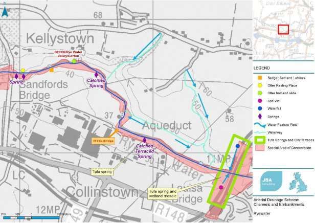
The work details for C1 Section B (1900-4000 chains) are of particular
importance as this is the channel section which is adjacent to the most sensitive
habitats and species found along the Rye Water, namely the petrifying springs
and two species of snail that represent the QI of the Rye Water Valley / Carton
SAC. In this channel section the proposed works are limited to:
• Bankside vegetation management using soft-felling methods with hand
tools; and
• Removal of tree blockages adjacent to Sandfords Bridge.
The works assessed here do not include access for any machinery into this
section except using, and not leaving, existing tracks and roads.
DJF-JBAI-XX-XX-RP-BD-0009-A3_C01_Ryewater_NIS 10Silt and vegetation management (A)
Typical maintenance of silt and vegetation will vary depending on the size of the
channel and whether a 15 tonne standard hydraulic excavator or long-reach
hydraulic excavator is required.
For small drainage channels (drainage ditches FW4 (1.5m wide) silt and emergent vegetation
such as Common Reed, Bur-reed and Bulrush growing across the channel width
are maintained by the removal of in-stream silts and emergent vegetation.
Sections of channel are also skipped where lamprey and white-clawed crayfish
are known to be present. The resulting spoil is spread out over the adjacent
bank within the maintenance access corridor.
Aquatic vegetation cutting (B)
This activity is not proposed for the Ryewater Scheme 2021-2026.
Bank protection (C)
No bank protection activities are proposed as part of the Ryewater Scheme
2021-2026.
Bush cutting / branch trimming (D)
Chainsaws or hydraulic secateurs mounted to an excavator are used to remove
branches and pollard trees. This includes trees in the Maintenance Access
Corridor (MAC) and trees overhanging the river where they might obstruct flow.
In sections of channels were the in-channels works take place in summer, this
activity will happen in the winter.
Tree cutting (E)
Chainsaws or hydraulic secateurs mounted to an excavator are used to remove
trees. This is needed where the capacity of the channel is reduced by trees
growing in the channel, or where trees have fallen into the channel. In sections
of channels were the in-channels works take place in summer, this activity will
happen in the winter.
3.3.2 Channel Maintenance
Plane Bed to Low Gradient Channels
All channels in the Ryewater scheme fall into this category. In such channels silt
and in-channel vegetation may cause the low flow level to rise by 50-300mm
above the Scheme design level. In such circumstances, maintenance is focused
on restoring both low-flow and flood-flow water levels to original Scheme
design.
Periods and Cycles of Maintenance
The majority of channels are maintained every 4 years, although the
downstream sections of the Rye Water are maintained once every 10 years.
3.3.3 Embankment Maintenance
No embankments are present within the Ryewater Scheme.
3.3.4 Structure Maintenance
Types of Structures Requiring Maintenance
In general, as channel maintenance proceeds, the bridges are examined by the
supervisory industrial staff and if required, repairs/replacements are scheduled.
DJF-JBAI-XX-XX-RP-BD-0009-A3_C01_Ryewater_NIS 11Where bridge maintenance may be required, a Bridge Inspection Form will be
filled out by the Foreman, prior to the works. This will determine the need for
further assessment and potentially, any mitigation measures that may be
required.
It is not known where sluice doors or structures may require maintenance on
the Ryewater Arterial Drainage Scheme. Maintenance of bridges, structures
and/or sluices will only occur within the scheme after following the relevant
environmental procedures and using specific mitigation measures as defined in
this document. Maintenance works for the purpose of this assessment will
include clearance of vegetation in and around the structures, clearance of in-
stream vegetation, repointing and surface repairs. This NIS does not include
assessment for the removal, demolition, replacement or erection of bridges,
sluices or structures.
3.3.5 Guidance for Drainage Maintenance Activities
The OPW Environmental Guidance: Drainage Maintenance and Construction
(Brew & Gilligan, 2019) sets out how Drainage Maintenance and Construction
work is to be carried out. The guidance document includes procedures which
are instructions to help OPW staff, in the form of a practical handbook. The
Guidance aims to deliver good drainage and flood relief functions while reducing
the associated environmental impacts.
Table 3-3: Drainage Maintenance Procedures and whether these are a
description of the project, or mitigation measures
Procedure Project Notes
Description,
Mitigation, or
other
Section 1A: Drainage Maintenance Planning Procedures
EP1 Annual Programme Project Applies to all maintenance.
Description
EP2 Environmental Risk Project Applies to all works to identify if
Assessment Description included in the project description of
the Appropriate Assessment.
EP3 Site Specific Mitigation As identified as being required by EP2.
Appropriate Assessment
EP4 Foreman Bridge Project Applies to all bridges, irrespective of
Inspection Form Description location.
EP5 Drainage Maintenance Project This procedure is for communication
Environmental Management Description of environmental management and
any mitigation measures with onsite
staff and others implementing
drainage maintenance activity.
Section 1B: Drainage Maintenance Implementation Procedures
EP6 Environmental Data Project Refers to weekly record cards which
and Usage Description are to be produced and collated for all
maintenance.
Also describes the data and
information that is made available to
onsite staff and others implementing
drainage maintenance activity.
EP7 Environmental Project This procedure describes how typical
Drainage Maintenance Description maintenance of channels and
embankments is to be carried out.
Included are some seasonal
restrictions on activities, which are
DJF-JBAI-XX-XX-RP-BD-0009-A3_C01_Ryewater_NIS 12Procedure Project Notes
Description,
Mitigation, or
other
requirements of other legislation:
- No maintenance within coarse fish
channels from 1st April to 1st July.
- Tree cutting window from 1st
September to 28th February.
- Work in gravel bed channels only
between 1st July and 30th
September.
The procedure also sets the annual
audit process of maintenance activity.
EP8 Environmental River Other This procedure relates to how to plan
Enhancement and undertake environmental river
enhancement work. Such work will be
subject to separate Appropriate
Assessment.
The enhancement of aquatic
habitats is not included within 5
year maintenance programmes
and is not to be considered as
project mitigation.
EP9 Tree Management Project This procedure relates to all tree and
Description bank top vegetation maintenance
(activity sub-categories D and E).
The procedure includes details of how
tree and vegetation clearance for
machine access corridors is to be
carried out. Machine access corridors
are necessary for all maintenance
work and so this procedure can also
apply to other maintenance sub-
categories.
EP10 Silt Management Project This procedure relates to all
Description maintenance activity.
EP11 Bank Protection Project This procedure relates to all
Description maintenance activity under sub-
category C.
EP12 Barrier Removal Other This is similar to EP8 and is not a
maintenance activity. Such work
will be subject to separate
Appropriate Assessment.
EP13 Embankment Project This procedure relates to all
Maintenance Description embankment maintenance activity
types.
Section 2: Construction Procedures
EP14 Construction Mitigation/Other These procedures do not relate to
Environmental Management typical drainage maintenance activity,
however they can be used as
EP15 Construction Silt
Management descriptions of mitigation measures to
avoid or reduce adverse effects.
EP16 Ecologically Friendly
Culvert
EP17 Water Pollution Project This procedure relates to all work
Description (maintenance and construction)
beside water bodies. It sets control
DJF-JBAI-XX-XX-RP-BD-0009-A3_C01_Ryewater_NIS 13Procedure Project Notes
Description,
Mitigation, or
other
measures to protect water bodies
from pollution sources associated with
works and machinery.
Section 3: Invasive Species Procedures
EP18A Standard Biosecurity Project This is a minimum requirement for all
Description works.
EP18B High Biosecurity Mitigation This procedure for enhanced
biosecurity measures is dependent
upon location.
EP18C Boat Cleaning Project This procedure is required for all works
Description where boats are used.
EP18D Invasive Plants Project The procedure contains avoidance
Treatment Description / rules which relate to all drainage
Other maintenance activities. Where
invasive plants cannot be avoided the
procedure describes treatment and
control measures. Treatment and
control is not included within the 5
year drainage maintenance
programme Appropriate
Assessment.
Section 4: Animal and Plant Procedures
EP19 Salmonid Project GIS layers are used to identify if
Description / species are likely to be encountered,
EP20 Otter
Mitigation however the species could occur in
EP21 Lamprey locations not already identified. If
EP22 Crayfish species or habitats are observed by
maintenance staff then the full
EP23 Badger procedure applies.
EP24 Bank Nesting Birds These procedures only apply to certain
EP25 Birds channels and embankments and so do
not apply to all maintenance activity.
EP26 Bats
Seasonal restrictions are already set in
EP27 Rare Plants EP7.
EP28 Freshwater Pearl
Mussel
Habitat Procedures
EP30 Alluvial (Wet) Project GIS layers are used to identify if
Woodland Description / habitats are likely to be encountered,
Mitigation however the habitats could occur in
EP31 Wetland
locations not already identified. If
EP32 Mudflat habitats are observed by maintenance
staff then the full procedure applies.
These procedures only apply to certain
channels and embankments and so do
not apply to all maintenance activity.
Seasonal restrictions are already set in
EP7.
EP1 Planning Procedure for Arterial Drainage Maintenance includes a range of
operations such as silt and vegetation management, mowing and structure
maintenance, as detailed in Table 3-2, and listed as channel, embankment or
structure maintenance in the table. The activities involved in each operation or
DJF-JBAI-XX-XX-RP-BD-0009-A3_C01_Ryewater_NIS 14drainage maintenance subcategory are described in general terms in Section
3.3.1. It is required to retain the arterial drainage scheme design capacity. All
maintenance activities (A to F) must comply with the relevant EPs.
An Environmental Risk Assessment (ERA) process has been developed by the
OPW which will be filled in by the program producer for >3m base width main
channels where maintenance has not occurred for 15 years and embankment
works where maintenance has not occurred for 15 years. The ERA form for this
process is in EP2 of the OPW Guidance Document.
3.3.6 Plant and Machinery
The types of machinery typically utilised during maintenance works would
include 360 hydraulic excavators (from 15-20 tonne excavators), mini-diggers,
tractors and trailers, tipper lorries, hydraulic shears, hydraulic secateurs,
chainsaws, mulchers and mowers; the machinery used is dependent on the
maintenance activity being conducted.
The removal of dense in-stream silt and vegetation requires the use of a
hydraulic excavator with a 1.5m wide (approximate) bucket (capacity
approximate 500ltrs).
Maintenance Access Corridors (MAC) and Working Zone
Maintenance sites are generally accessed via the public road and through
farmland. A maintenance access corridor is utilised along one side of a channel
for maintenance purposes. These established routes are used to track the
hydraulic excavators for maintenance and for the disposal of spoil. The same
route is generally followed every maintenance cycle. This approach avoids
disturbance of habitats on the opposite bank during works.
Structures are generally accessed through farmland from the public road above.
Plant machinery will utilise the same maintenance access corridor used for
channel maintenance to gain access to the structure. Where individual trees,
woodland and scrub habitats are present at the location of the structure, these
may be removed to facilitate bridge inspection and works. Where mature trees
are present these are generally avoided by plant machinery.
3.3.7 Site Compounds (Welfare Facilities), Access Routes and Haul
Roads
Haul roads are generally not required to facilitate drainage maintenance
activities. Where access is required in soft ground conditions, plant equipment
will be brought in on tracks or temporary matting will be laid to provide a
corridor for machinery access. Where matting is utilised, it will be completely
removed post completion of works to allow vegetation to recolonise. All plant
and machinery are confined to one defined access route to minimise
disturbance.
All plant and machinery are regularly maintained and serviced to minimise
release of hydrocarbons. All hydraulic excavators and other plant machinery use
long life engine oil and biodegradable hydraulic oil. Fuelling and lubrication are
conducted a minimum of 50m away from all channels. Spill kits are present in
all plant used in maintenance activities. Integrated submersible pumps are also
deployed in the event of structural maintenance and the requirement for
dewatering of excavations.
The location of drainage maintenance works is generally accessed via public
roads and through farmland, with the siting of mobile short-term staff welfare
facilities, plant storage and car parking agreed with local landowners. There is
no requirement for temporary site lighting.
DJF-JBAI-XX-XX-RP-BD-0009-A3_C01_Ryewater_NIS 153.3.8 Waste Output/Disposal
The material removed from a channel during silt and vegetation management is
normally spread thinly along the bank or on top of existing spoil heaps where
present within the access corridor. All dead wood material is left on site to
decompose or may be removed off site if suitable arrangements are in place.
Where mulchers or mowers are deployed, the arisings are left on site to
decompose or the mulched material is buried.
Construction and demolition waste from structures includes broken concrete and
stone. Steel railings are returned to the depot for recycling. Used engine oil and
hydraulic oil is disposed of by a licensed waste handler. Toilet facilities are
maintained by a licensed waste handler. Any waste generated on site is
returned to the depot for segregation and disposal by a licensed waste handler.
3.3.9 Working Hours
All maintenance activities are undertaken during daylight hours. Standard
working hours are 8.00am to 4.30pm, with lunch and tea breaks, Monday to
Friday. There is no requirement for temporary site lighting to facilitate works.
Machines are powered down when not in use.
3.3.10 Environmental Training
Environmental training of all staff involved in drainage maintenance is an
ongoing process. Technical and Operational Staff have completed formal training
in Environmental Drainage Maintenance (EDM) since 2004. The training courses
were revised and expanded under the OPW’s Environmental River Enhancement
Programme (EREP) and delivered to all staff in 2010. The training programme
delivered included presentations in river corridor ecology, the Environmental
Drainage Maintenance Guidance Notes (Ten Steps to Environmentally Friendly
Maintenance), maintenance strategies involving both ‘enhanced maintenance’
and ‘capital enhancement’, and OPW’s Environmental Management Protocols
and Standard Operating Procedures (SOPs). Both sets of training were
developed and delivered by Inland Fisheries Ireland (IFI).
The formal approach to EDM Training is complimented with on-site training.
Regular site visits from OPW’s Environment Section provide further guidance
and advice to operational staff. Auditing of operational staff on the
implementation of the Environmental Drainage Maintenance Guidance Notes
(Ten Steps to Environmentally Friendly Maintenance (OPW, 2011b) is also
carried out by both OPW’s Environment Section and JBA Consulting.
An environmental training course was designed and provided by JBA to all OPW
staff in 2017 and 2018. It was given in three different stages. Management staff
were given a more detailed 2-day course in Environmental and Ecological
training. Ground staff were given 1.5 days of training in the environment and
ecology. Modules were designed to assist staff in understanding the relevant
legislation, recognising ecologically sensitive habitats and species, invasive non-
native species identification and general environmental and ecological training
relevant to their work. This included a half day practical session where
ecologists demonstrated the identification of the elements taught in the
classroom, in the field.
More recently, the OPW Environment Section with external environmental
groups, provide annual training to all Foreman and Engineers in Arterial
Drainage Maintenance. This training includes updates/refresher training of
Environmental Guidance: Drainage Maintenance & Construction document,
providing EREP work examples/ best practice, understanding the AA process and
Q&A session.
DJF-JBAI-XX-XX-RP-BD-0009-A3_C01_Ryewater_NIS 16Training in the completion of an Environmental Risk Assessment and Bridge
Inspections from an ecological perspective, was designed and provided by JBA
Consulting to OPW Foremen and selected engineering staff in 2018.
3.3.11 Environmental Audits
A portion of operational crews have been audited annually by the OPW
Environment Section, IFI and in 2018 and 2019 by consulting ecologists for the
implementation of the Environmental Drainage Maintenance Guidance Notes
(Ten Steps to Environmentally Friendly Maintenance) and the OPW’s
Environmental Management Protocol and EPs. Auditing is carried out on a
rotational basis to ensure all operational crews are themselves audited at least
once every three years. All audit results are discussed on-site and forwarded in
full to the relevant engineer for that Scheme within two working weeks. In the
event of an audit showing elements of unreasonable non-compliance with
procedures, the relevant Engineer will be notified within one working day. Audit
results are also forwarded to OPW Systems Manager for inclusion in monthly
regional benchmarking reports.
3.3.12 Maintenance works considered outside of the Scheme Design
Standards and outside of normal Arterial Drainage Maintenance
Works
Occasionally, works are required that can be considered outside of the scope of
the normal Arterial Drainage Maintenance Works to maintain a scheme. Works
considered outside of the normal scope of statutory arterial drainage
maintenance works as detailed in terms of the activity and channel
reference specified in the 5-year maintenance programme have are not
assessed for impacts in this report.
Works that could be considered outside of the normal scope of works include
those involving extensive bank protection measures, removal of mature
woodland, unplanned bridge maintenance works or any other unplanned works
within the zone of influence of a Natura 2000 site. These are normally identified
by OPW staff as a result of EP2 of the Environmental Procedures through the
ERA process.
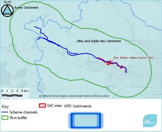
3.4 Project Zone of Influence
The project zone of influence for this NIS is based on the screening tables in
Ryan Hanley (2014a). The maximum distance for surface water pathways,
35km, applies only to schemes on rivers with Freshwater Pearl Mussel
Margaritifera margarifitera and Nore Pearl Mussel Margaritifera durrovensis.
These species are not known to be present in the area and are not a qualifying
interest (QI) feature of any nearby SAC. Therefore an initial screening distance
of 15km is used to identify sites in close proximity to the scheme, and
subsequently these sites are screened using the criteria for each pathway listed
in Hanley (2014a,b) to determine if there are any likely significant effects which
need further consideration.
DJF-JBAI-XX-XX-RP-BD-0009-A3_C01_Ryewater_NIS 174 Ecology Baseline
4.1 Overview
This section summarises the findings of the ecological walkover surveys of the
river channel and the results of the desktop survey relative to the proposed
works for the Ryewater Arterial Drainage Scheme (2021-2026). The habitat and
species results in this chapter are a result of the data gathered from both the
desktop review and the walkover surveys. Desktop review data was collated
from NBDC database and included protected habitats and species recorded as
being present within the surrounding 10 km areas of the Scheme, within the
past 10 years. Data was gathered from the four 10km grid squares that
encompass the entire works of the scheme and collated in a spreadsheet.
A complete GIS database containing all species and habitats identified during
the walkover surveys, including those relevant to the NIS and those not relevant
but ecologically significant or protected under other legislation, has been
provided separately to the OPW.
4.2 Habitats
Habitat data is compiled from desk-based sources and fieldwork. The Annex I
habitats occurring in proximity to the scheme are given in Table 4-1.
Table 4-1: Annex 1 habitats recorded along Rye Water Scheme
Annex I Habitat Type Equivalent Location and source
Fossitt
Habitats
7220 Petrifying springs with FP1 Desk based, in grid squares N83,
tufa formation N84 (NPWS data).
(Cratoneurion) Field surveys found this habitat at
Louisa Bridge and evidence of this
habitat forming behind Intel on the
southern bank of the Rye Water
and on the northern bank running
from the Shaughlin's Glen.
Habitats identified according to Fossitt (2000), during the 2020 ecological
walkover survey, including details of plant species found are provided in the
following sections. Where no species of interest were noted during the survey,
the description of species present is as identified in Fossitt (2000).
4.2.1 7220 Petrifying springs with tufa formation (Cratoneurion)
This habitat occurs within FP1 (Section 4.2.7) and locations relevant to drainage
maintenance were mapped in a detailed survey in 2018 (JBA 2018). These
showed that in several locations the springs occur on the floodplain adjacent to
the channel (paludal type; Lyons & Kelly 2016). These springs are dependant on
the hydrology of the valley which is sensitive to disturbance and alterations to
water flows.
DJF-JBAI-XX-XX-RP-BD-0009-A3_C01_Ryewater_NIS 18You can also read