TE MATA PEAK TRACK INVESTIGATION INTO OPTIONS - FOR THE - Craggy Range
←
→
Page content transcription
If your browser does not render page correctly, please read the page content below
INVESTIGATION INTO OPTIONS
          FOR THE

TE MATA PEAK TRACK
          Prepared by

          7 May 2018
Prepared by

      Hudson Associates

   Registered Landscape Architects

    PO Box 8823 Havelock North

          Ph 06 877-9808

    john@hudsonassociates.co.nz

    www.hudsonassociates.co.nz

                For

Craggy Range Vineyards Limited

            7 May 2018

                                     INVESTIGATION INTO OPTIONS FOR THE TE MATA PEAK TRACK   2
CONTENTS
INTRODUCTION                                                 4    Figure 8 - Rocks embedded within the topsoil layer                      7
METHODOLOGY                                                  6    Figure 9 - Rockfall across adjacent land                                8
EXISTING ENVIRONMENT                                         6    Figure 10 - Rockfall adjacentto the track                               8
LANDSCAPE ASSESSMENT FACTORS                                 7    )LJXUH)OD[WKULYLQJRQWKHFOLϑV
     Physical Character                                      7    Figure 12 - Lesser depth of topsoil (exposed by the track cut)          8
     Perceptual                                              9    Figure 13 - Greater depth of topsoil (exposed by the track cut)         8
     Associational                                           13   Figure 14 - Weeds establishing along the track edges                    9
           Cultural Associational Values                     13   Figure 15 - Upper portion of track (Section 6)                          9
           Recreation and public networks                    15   Figure 16 - View looking along the ridgeline from Te Mata Peak          10
EFFECTS                                                      18   Figure 17 - Pines along the northern portion of the landform            10
     Track Visibility                                        18   Figure 18 - Weeds such as woolly mullein present in pasture             10
REMEDIATION/MITIGATION OPTIONS                               21   Figure 19 - Brighter green line of weeds and dark line of cut topsoil   11
     Remediation                                             21   Figure 20 - Exposed topsoil and colluvium                               11
     Restoration                                             22   Figure 21 - Sods and spill placement                                    11
     Additional Mitigation                                   23   Figure 22 - Weeds growing along the track                               12
     Forced Abandonment                                      26   Figure 23 - View from Te Mata Peak Lookout (11 December 2017)           12
     Compliance                                              27   Figure 24 - View from Te Mata Peak Lookout (23 April 2018)              12
EVALUATION                                                   27   Figure 25 - Children’s Book Cover (Illustration by Sophie Blokker)      14
     Land Management                                         29   Figure 26 - Old Havelock North post card                                14
ALTERNATIVES                                                 29   Figure 27 - Track Summit in relation to the wider landform              14
     Alternative Route                                       29   Figure 28 - Craggy Range Winery to Te Mata Peak Lookout                 15
     Revegetation                                            30   Figure 29 - Combined Te Mata Park walking and Cycling Map               15
CONCLUSION                                                   31   Figure 30 - Public Access link along the Te Mata ridgeline              16
                                                                  Figure 31 - 20km cycling loop                                           16
                                                                  Figure 32 - Hawkes Bay Cycle Network                                    16
ATTACHMENTS                                                       )LJXUH2ϑURDGF\FOHOLQNFRQFHSW :DLPDUDPD5RDG
Attachment 1 - Track Sections Plan                                Figure 34 - Usage on Monday 2nd April at 2pm                            17
Attachment 2 - Track Sections Photo                               Figure 35 - View toward track from Craggy Range Winery                  18
Attachment 3 - Orthographic Image                                 Figure 36 - View toward track from Te Mata Peak Lookout                 18
Attachment 4 -Track Meterage Reference Plan                       Figure 37 - View toward track from Waimarama Road                       19
Attachment 5 -Track Meterage Overview Plan                        Figure 38 - Sun position example 1 (9:15am)                             19
$WWDFKPHQW:HHG,GHQWL¿FDWLRQ/LVW                             Figure 39 - Sun position example 2 (11:31am)                            19
Attachment 7 -Mountain Bike and Walking Track Maps                Figure 40 - Sun position example 3 (2:04pm)                             19
Attachment 8 -Proposed Broad-Scale Vision: Park Tracks Plan       Figure 41 - Sun position example 4 - Overcast (11:40am)                 19
Attachment 9 -Plaques at the top of Te Mata Peak                  )LJXUH([LVWLQJWUDFNWREHVFDUL¿HGEHIRUH¿OOSODFHPHQW
Attachment 10 - Tourism NZ and Te Mata Park Website Information   Figure 43 - Sods along the side of the track                            24
                                                                  Figure 44 - Rockfall and muehlenbeckia below meterage 1130              24
                                                                  Figure 45 - Shortcuts formed on lower portions of the track             24
FIGURES                                                           Figure 46 - Loose soil will support continued weed growth               26
Figure 1 - Original Track Proposal                           4    Figure 47 - Tension cracking occurring                                  26
Figure 2 - Distinct geological formations                    4    Figure 48 - Slippage and erosion                                        26
Figure 3 - Te Mata Track                                     5    Figure 49 - Lowe Track Aerial Photograph (October 2014)                 28
Figure 4 - Track Sections Plan                               6    Figure 50 - Lowe Track Drone Photograph (May 2018)                      28
Figure 5 - Track Sections Photo                              6    Figure 51 - Lowe track Photo (2014)                                     29
)LJXUH7H0DWD3HDN'UDPDWLF%OXϑV                      Figure 52 - Lowe track Photo (2018)                                     29
Figure 7 - Fossils                                           7    Figure 53 - Revegetation Option (Craggy Range Land)                     30

                                                                                  INVESTIGATION INTO OPTIONS FOR THE TE MATA PEAK TRACK        3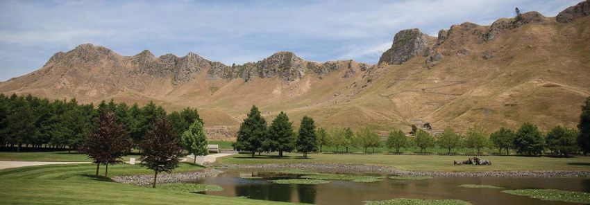
Figure 1 - Original Track Proposal
INTRODUCTION
In early 2017, Craggy Range Vineyards Limited began investigation into building a

track to provide a link from opposite their property on Waimarama Road up to the

top of the Te Mata Peak ridgeline. The route would climb the eastern side of the

ridge (Figure 1). The purpose of the track is to provide public walking access from

the lower lands on the eastern side to the ridgeline. This is to enable appreciation

of the spectacular views of the Tukituki Valley and provide an intimate experience

of the landscape characteristics of the Peak, including the distinctive geological
                                                                                            Figure 2 - Distinct geological formations
formations of the exposed ridge (Figure 2).

The track is to be available for public use, with Craggy Range facilitating this through

an easement in gross (right of way for pedestrians) in favour of Hastings District

Council over the land. That is a condition of consent. Craggy Range contracted

to purchase the 4.9 ha strip of land required for the track and also put in place a

commitment through the easement to maintain it. The company will, under the

consent, meet all the development costs and maintain the track in a condition

appropriate for safe public use. The easements for public use and maintenance will

be in perpetuity.

In September 2017 Craggy Range applied for resource consent to construct

the walking track. This was granted by Hastings District Council on 17 October
                                                                                           This report was commissioned by Craggy Range to assess the remediation and
and construction started immediately. The track was largely completed by early
                                                                                           mitigation options that should be considered as part of an informed assessment of
December 2017. However, all work and maintenance were halted in mid-December.
                                                                                           the options. In undertaking the assessment Hudson Associates was instructed to also
Subsequently the public have made extensive and unauthorised use of the track.
                                                                                           consider the impacts of various options or outcomes considering the values attributed

Varied public reaction followed the building of the track, with some positive and some     by the community to Te Mata Peak.

QHJDWLYH7KHUHZHUHDOVRSHUFHLYHGDGYHUVHHϑHFWVRIWKHWUDFNRQWKHODQGVFDSH

and cultural values of Te Mata Peak. In response to these objections, Craggy Range         Three categories of remediation and additional mitigation     have been considered

said it would investigate remediation of the track.                                        in this report. The “Compliance” and “Abandonment” options/outcomes are also

                                                                                           considered as being legal outcomes if remediation or additional mitigation solutions

                                                                                           are not implemented:

                                                                                                             INVESTIGATION INTO OPTIONS FOR THE TE MATA PEAK TRACK            4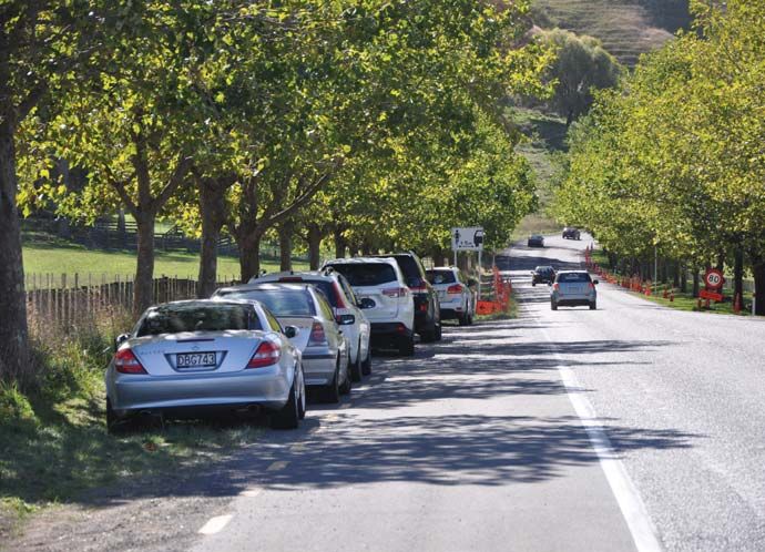
1. 5HPHGLDWH ±¿OO WKH WUDFN ZLWK VSLOO PDWHULDO SXVKHG RYHU WKH HGJH GXULQJ LWV

       construction, thereby precluding access to the track and close the track.

    2. Restore – complete reinstatement of the hillside and close the track.

    3. Additional Mitigation – undertake additional work within the scope of the

       FXUUHQWFRQVHQWWRPLQLPLVHDGYHUVHODQGVFDSHDQGYLVXDOHϑHFWVDQGWKHWUDFN

       remains open.

    4. Forced Abandonment- Abandon the track and do nothing, which could happen

       if the consent is set aside by a successful judicial review. Craggy then has no

       consent but is not obliged to do anything either. Craggy’s only option is then

       to embark on a contentious legal process to re-consent or remediate. Craggy

       will not embark on such a process.

    5. Compliance – leave the track in its current state with any necessary steps to

       complete and implement the consent, including subdivision and maintain in                      Figure 3 - Te Mata Track
       accordance with consent conditions.                                                           Implementation of this remediation option would prevent public access and leave

                                                                                                     a permanent scar across the hillside and is potentially inferior to Category 2 and 3
Categories 3 & 5 would allow the track to remain open for public use and satisfy the
                                                                                                     options as the lack of maintenance and general deterioration in track condition will do
conditions of consent. Craggy Range can complete its purchase of the land and vest
                                                                                                     QRWKLQJWRPLWLJDWHWKHHϑHFWV
the easements for public access and achieve ongoing maintenance.
                                                                                                     Craggy Range commissioned this report to investigate remediation methods for the
Categories 1, 2 and 4 would not allow Craggy Range to complete the conditions of
                                                                                                     Track. These include the option of Additional Mitigation while retaining the track,
consent or purchase of the land and no public access would be provided.
                                                                                                     given that some restoration and remediation may require new consents and thus

&DWHJRU\  LV WKH RSWLRQ RI UHWULHYLQJ WKH ORRVH ¿OO WKDW KDV EHHQ SXVKHG RYHU WKH   ZLOO OLNHO\ SUHVHQW GLϒFXOWLHV QRW DQWLFLSDWHG E\ &UDJJ\ 5DQJH LQ 'HFHPEHU

side during construction, placing it on the existing gravel path and spreading grass                 (Figure 3). This report examines options, ranging from simply allowing time to keep

VHHGRYHUWKHVRLOVXUIDFH7KLVLVWKHRSWLRQWKDWZDVRϑHUHGE\&UDJJ\5DQJHWR                   LPSURYLQJ WKH VLWXDWLRQ RU UHGXFH WKH HϑHFWV RI WKH QHZO\ FRQVWUXFWHG WUDFN ULJKW

representatives of interested parties at a meeting 5 January 2018. It was stated that                through to reversal by physical intervention. The options span from simply regrassing

this would not restore the land to how it was before and would leave a shadow line.                  the exposed cut through to imposing an engineered solution such as construction of

All parties agreed it was all that could practically be done, and they were not seeking              UHWDLQLQJV\VWHPVDORQJWKHWUDFN¶VOHQJWKDQGLPSRUWLQJPDWHULDOWR¿OOWKHVH7KH

any more than that.    1
                                                                                                     alternatives are summarised as categories 1-5 above but explored in more detail

1       Record of meeting with representatives from HDC, HBRC, Te Mata Park Trust, Ngati             within this report.
Kahungunu, Waimarama Hapu, Craggy Range.

                                                                                                                           INVESTIGATION INTO OPTIONS FOR THE TE MATA PEAK TRACK                 5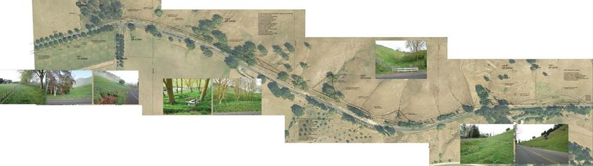
METHODOLOGY
Hudson Associates Landscape Architects prepared this report. Hudson Associates                   Section 4. Large zig zags across the broad slopes of the hillside. Total length comprising
FRPPLVVLRQHGH[SHUWVLQWKH¿HOGVRIJHRWHFKQLFDOHQJLQHHULQJSODQQLQJSODQWLGHQWL¿FDWLRQ    4 zig zags of track rising from the raised terrace to the lower edge of the exposed

and orthomapping. The format of the report follows that of a landscape assessment, where         limestone outcrop. Runs from meterage 750m – 1230m, being a total length of 480m.

the existing environment’s physical, perceptual and associational values are described,          This includes the longest single length of track, being 170m of linear cut across the

WKHQHϑHFWVRIWKHUHVSHFWLYHUHPHGLDWLRQRSWLRQVDUHFRQVLGHUHGDJDLQVWWKHVHFDWHJRULHV      hillside (980m-1150m), and the most obvious section of zig zags.

:D\¿QGHUV/DQGVFDSH$UFKLWHFWVZLOOSHHUUHYLHZWKLVUHSRUW
                                                                                                 Section 5. A shorter grouping of three lengths from 1230m – 1450m, ending at the
                                                                                                 EDVH RI WKH ODUJH VRXWKHUQ OLPHVWRQH EOXϑ 0HWDO SODFHPHQW RQ WKH WUDFN VXUIDFH
EXISTING ENVIRONMENT
                                                                                                 ¿QLVKHVDWWKHWRSRIWKLVVHFWLRQEHLQJWKHKLJKHVWSRLQWWKDWFRXOGEHDFFHVVHGE\
The Craggy Range Walking Track, that forms part of the existing environment, climbs the          the small digger used for the excavation and carrying of metal.
eastern side of Te Mata Peak Ridge, starting from Waimarama Road opposite Craggy Range                                                             Figure 5 - Track Sections Photo
                                                                                                 Section 6. A series of shorter zig zags
winery and following a zig-zag route to reach the ridgeline at an elevation of 300m. The
                                                                                                 that weave up a recessed valley between
route comprises six sections (Figure 4 & 5, along with Attachments 1 - 5):
                                                                                                 the limestone outcrops and ends at the
Section 1. Flat straight length across the cultivated river terrace from Waimarama Road to       ridgeline, covering a meterage from 1450m
the base of the hillside, total length 190m                                                      – 1790m. Cut by hand and narrower than

Section 2. Gentle meander between lower slopes of the hillside. Short cuts have been created     the rest of the track, with a surface of bare

between the bends of the zig zagging route, giving a straight length of 90m or the formed        earth and retained on corners by small

track length from 190m - 490m. Generally recessed from view from below due to the low            timber crib walls. Less visible than the

elevation and screening from adjacent slopes.                                                    lower sections of track due to the recessed

                                                                                                 location between the rock outcrops, the
Section 3. Several shorter zig zags across the lower slopes of the hillside and within the
                                                                                                 shorter lengths of track and the narrower
context of the raised terrace that runs across the whole eastern face. Total length comprising
                                                                                                 cut used in the construction.
three zig zags running from 490m - 750m.

         ^ĞĐƟŽŶϲ
                                                  ^ĞĐƟŽŶϰ
                                                                                 ^ĞĐƟŽŶϯ                                                        ^ĞĐƟŽŶϭ
                       ^ĞĐƟŽŶϱ
                                                                                                    ^ĞĐƟŽŶϮ

 Figure 4 - Track Sections Plan

                                                                                                                    INVESTIGATION INTO OPTIONS FOR THE TE MATA PEAK TRACK                 6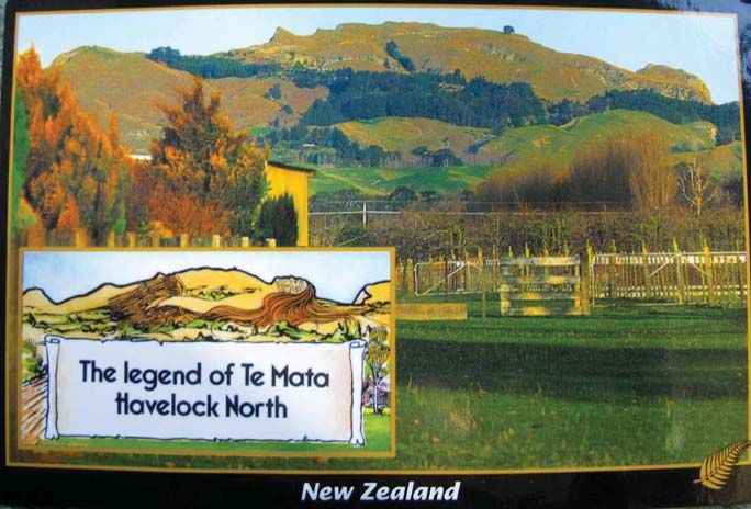
LANDSCAPE ASSESSMENT FACTORS

Physical Character

Te Mata Peak is a prominent karst landscape2 formed through uplift of limestone

deposits, tilted as a cuesta ridgeline landform through tectonic action, with exposed

limestone outcrops and steep colluvium pasture covered slopes facing eastward

towards the Tukituki River. Scree talus slopes are characteristic of the geology, while

URFNIDOOGHEULVIURPWKHOLPHVWRQHFOLϑVIDQDFURVVWKHVRXWKHDVWVORSHJLYLQJDFOHDU

illustration of the uplift and erosion that has formed the Peak.

7KHJHRORJLFDOFRPSRVLWLRQRIWKHOLPHVWRQHWKDWFRPSULVHWKHGUDPDWLFEOXϑV )LJXUH

6) is derived from depositional sedimentary material that once formed the sea bed.

Infused with fossilised shells (Figure 7) and compressed into rocks over time by the

GHSWKRIGHSRVLWLRQWKHEOXϑVODFNWHQVLOHVWUHQJWKDQGDUHYXOQHUDEOHWRZHDWKHULQJ                       )LJXUH7H0DWD3HDN'UDPDWLF%OXϑV

and erosion. This can contribute to rockfalls that have occurred over geological time,

HYLGHQFHGE\OLPHVWRQHIUDJPHQWVRIYDU\VL]HRQWKHVORSHVEHORZWKHH[SRVHGFOLϑV

Small rocks are embedded within the eroded colluvium that makes up the topsoil and

underlying material of the pastoral slopes (Figure 8). Small rocks are also apparent

on the pastoral surface in valleys leading down from the source material above, while

some larger boulders have rolled further down the hill and now resting on the upper

terraces or strung down the slopes above. Ongoing weathering is apparent within the

EOXϑVZLWKDUHDVRIDFWLYHHURVLRQFRQWLQXDOO\RFFXUULQJDQGFUHDWLQJDVRXUFHRI¿QHU                     Figure 7 - Fossils
sedimentary material, while larger fractures can be seen that will, in time, create

¿VVXUHVDQGUHOHDVHURFNVDQGERXOGHUVGRZQWKHKLOOVLGHFRQWLQXLQJWKHSURFHVVWKDW

has occurred over millennia.

2        Karst is a topography formed from the dissolution of soluble rocks such as limestone, dolomite,
and gypsum. It is characterized by underground drainage systems with sinkholes and caves. It has also been
documented for more weathering-resistant rocks, such as quartzite, given the right conditions. Wikipedia

                                                                                                             Figure 8 - Rocks embedded within the topsoil layer

                                                                                                                              INVESTIGATION INTO OPTIONS FOR THE TE MATA PEAK TRACK   7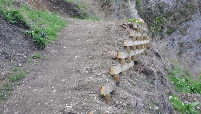
2Q D ¿QHU JUDLQ WKHVH SDWWHUQV RI HURVLRQ DQG GHSRVLWLRQ FRQWULEXWH WR YDULDWLRQV

in landscape character across the slopes, with larger boulders apparent south of

the track on the neighbouring property (Figure 9) and collections of smaller rocks

within the topsoil and on the surface down valleys above meterage 640 (Figure 10)

DQG EHORZ PHWHUDJH  7KLV PLFUR FKDUDFWHU LV DOVR UHÀHFWHGLQ WKH YHJHWDWLRQ

types that are occurring within the pastoral overlay, with clumps of Muehlenbeckia

developing in the dryer rockier slopes.

                                                                                                   )LJXUH)OD[WKULYLQJRQWKHFOLϑV

                                                                                                  Just as rocks are present within and upon the pasture, the depth of soils and underlying

                                                                                                  material vary across the hillside. The most apparent is at meterage 1030 where the

                                                                                                  ridgeline has a lesser depth of covering topsoil (Figure 12) and the track excavation

                                                                                                  has exposed an area of less weathered limestone. Visible due to its lighter colour and

                                                                                                  ¿QHUWH[WXUHWKLVFRQWUDVWVZLWKPRVWRWKHUFXWVZKHUHWKHWRSVRLOOD\HULVWKLFNHU

                                                                                                  and the underlying material is coarser grain weathered colluvium of a mid-brown

                                                                                                  colour (Figure 13).

Figure 9 - Rockfall across adjacent land          Figure 10 - Rockfall adjacentto the track

$YDULHW\RIQDWLYHÀRUDDUHDOVRSUHVHQWDFURVVWKHOLPHVWRQHFOLϑVDQGZLWKLQUHFHVVHG

DUHDV RI WKH XSSHU VORSHV .RZKDL PRXQWDLQ ÀD[ ZKLWH\ ZRRG DQG ROHULD FDQ EH

found, with hebe also present amongst the coverage of exotic weeds on parts of the

EOXϑV7KHPRVWSUROL¿FRIWKHQDWLYHVSHFLHVLVWKHPRXQWDLQÀD[ZLWKODUJHFOXPSV              Figure 12 - Lesser depth of topsoil (exposed by the track cut)

GHYHORSLQJRQDUHDVRIWKHPRUHLQDFFHVVLEOHOLPHVWRQHFOLϑVDQGUHFHVVHGDUHDVRI

topsoil (Figure 11). It is not uncommon for this species to form a complete coverage

in such an environment, withstanding the dry and windy conditions and seeding

LQWRFUHYLFHVDQGWKHIHUWLOHEDVHURFN)XUWKHUWRWKHVRXWKRQWKHEOXϑVEHORZWKH

ORRNRXWDQGDGMDFHQWFOLϑVÀD[LVEHFRPLQJZHOOHVWDEOLVKHGDQGLWVÀHVK\IRUPKDV

DVVLVWHGLWVUHYLYDODIWHUWKHGHYDVWDWLRQRIRFFDVLRQDO¿UHV
                                                                                                   Figure 13 - Greater depth of topsoil (exposed by the track cut)

                                                                                                                    INVESTIGATION INTO OPTIONS FOR THE TE MATA PEAK TRACK              8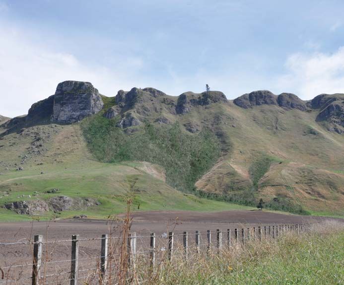
While the overwhelming impression is that of a clean pastoral cover, closer inspection   Perceptual
UHYHDOVDGLYHUVLW\RIEURDGOHDISODQWVZLWKLQWKHSDVWXUHDQGDFURVVWKHEOXϑVDQG
                                                                                         The physical attributes of the landform and ridgeline and eastern hillside contribute
valleys of the upper outcrops. Weeds are present (Attachment 6), with a variety
                                                                                         WRLWVDHVWKHWLFTXDOLWLHVZLWKSK\VLFDOIDFWRUVVXFKDVWKHFROOXYLXPUXQRϑDQGWDOXV
establishing across fresh soil exposed during the track construction process (Figure
                                                                                         slopes3 creating a steep fan shaped side slope that is consistent along the full eastern
14). Thriving on freshly exposed topsoil, their wide variety and vigour has enabled
                                                                                         OHQJWKRIWKHULGJHEHORZWKHOLPHVWRQHEOXϑV
rapid development of a lush green corridor tracing the alignment of the track right
                                                                                         The rock outcrops and pastoral land use give these eastern facing slopes a consistent
up the hillside.
                                                                                         character, prominent and expressive of its formative processes. These formative

                                                                                         processes of uplift and fan erosion are clearly visible, with its legibility accentuated

                                                                                         by the consistency of the pastoral land cover that clothes the slopes like a uniform

                                                                                         blanket of colour, height and texture. It has a simplicity due to the smoothness and

                                                                                         large scale of the fans and pastoral land use and extensive nature of the outcrops,

                                                                                         but within these outcrops there is a complexity due to the varied topography, erosion

                                                                                         patterns, recessed valleys and emerging vegetation variance when examined at a
 Figure 14 - Weeds establishing along the track edges
                                                                                         closer scale.
The top section of the track (Section 6 – Figure 15) contains small zig zags generally
                                                                                         The background landscape report and the District Plan describe Te Mata Peak as follows:
located between large rock outcrops that form part of the tilted karst limestone
                                                                                         ‘The uninterrupted skyline, distinct pasture covered landform, open pastoral hillsides,
outcrops characteristic of the eastern side of Te Mata Peak. Excavated by hand, this
                                                                                         distinctive geology and rock outcrops are the documented physical characteristics4
440m section of track is narrower than the lower section where a digger assisted the
                                                                                         that contribute to the outstanding landscape qualities of Te Mata Peak. Management
construction. A series of small timber crib retaining walls are located on the corners
                                                                                         of the open rural context of the steep slopes and avoiding buildings on these, retention
to give support and width to the track. The track surface is exposed topsoil, being a
                                                                                         of the open uninterrupted skyline between Te Mata and Mt Erin, and management of
dark brown colour. No metal has been placed on this section of the track.
                                                                                         IRUHVWU\DUHLWHPVFXUUHQWO\LGHQWL¿HGDVPDQDJHPHQWLVVXHV¶5.

                                                                                         3         Encyclopedia.com. Talus pile or talus slope. Geologists define talus as the pile of rocks that accumulates
                                                                                         at the base of a cliff, chute, or slope. The formation of a talus slope results from the talus accumulation.
                                                                                         4         Boffa Miskell Review of Landscape Areas and Implications for Plan Review | Hastings District Council
                                                                                         This review also notes that ‘The Maori cultural history of the feature is well known by both Tangata Whenua and
                                                                                         the wider community and is depicted on information panels at the summit of the mountain and on Tourism
                                                                                         NZ publications’.
                                                                                         5         Proposed Hastings District Plan Appendix 43 Outstanding Natural Features and Landscapes
 Figure 15 - Upper portion of track (Section 6)

                                                                                                                  INVESTIGATION INTO OPTIONS FOR THE TE MATA PEAK TRACK                                   9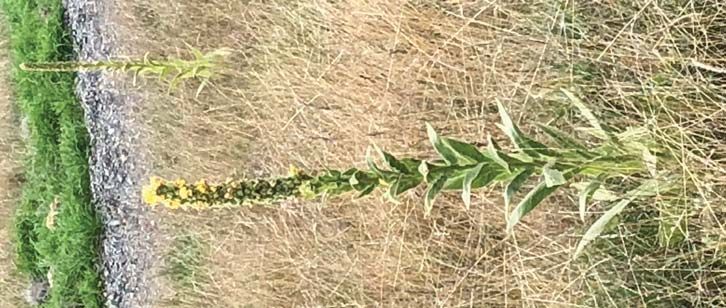
The current pastoral land use of grazing that is continued across the titles of the two             The land cover is pasture grasses, predominantly rye, cocksfoot and browntop, with

major landowners contributes to the distinct pasture covered landform and open                      tall seed-heads giving the hillside a continuous golden-brown hue in summer. This

SDVWRUDO KLOOVLGH EHORZ WKH GLVWLQFWLYH OLPHVWRQH EOXϑV DV UHIHUUHG WR DERYH LQ WKH   GDUNHQVWRDULFKHUJUHHQZLWKWKHLQÀXHQFHRIUDLQW\SLFDOO\RFFXUULQJLQWKHZHWWHU

background landscape report and the District Plan. Cattle and sheep graze the slopes                seasons of winter and spring but also in autumn, depending on the year’s rainfall

along the southern portion of the face, while cattle are the main livestock on the                  pattern. Weeds such as thistle and woolly mullein are present through the pasture,

northern portion (Figure 16).                                                                       but these appear to have been kept at bay through cattle grazing and occasional

                                                                                                    aerial application of herbicide (Figure 18) .

                                                                                                    The walking track zig zags within a

                                                                                                    200m wide fenced strip that runs

                                                                                                    up the hillside. The southern fence

                                                                                                    forms the existing boundary with the

                                                                                                    neighbouring farm, while the northern

                                                                                                    fence is newly constructed and forms

                                                                                                    the boundary with the Drabble farm,
 Figure 16 - View looking along the ridgeline from Te Mata Peak lookout                             from whom the 4.9ha of track land is
Finer topographic detail emerges towards the northern portion of the slopes, with                   being purchased.     Since construction
increasing undulation between the ridges and their separating valleys that run down                 of the northern fence, stock has been
the hill face. Additionally, the growing presence of rogue pine trees hide aspects of               excluded from the track land, with
the topography and pasture on these northern grades, reducing the simplicity and                    SDVWXUH DQG ZHHG JURZWK ÀRXULVKLQJ
visual coherence of the slopes (Figure 17). Within these folds to the north lies the                Weeds are particularly prevalent on
Lowe mountain bike track, constructed two years ago and well-integrated into the                    the exposed topsoil that has been
pastoral slope.                                                                                     newly placed from excavation for the

                                                                                                    track construction. These weeds are

                                                                                                    intermingled with regrowth of grasses

                                                                                                    from placed sods and adjacent seed

                                                                                                    KHDGVDOORZLQJDIUHVKÀXVKRIYHUGDQW

                                                                                                    green along edges of the track surface

                                                                                                    DQGZLWKLQVRPH¿OODUHDVRIWRSVRLO             Figure 18 - Weeds such as woolly

 Figure 17 - Pines along the northern portion of the landform                                                                                          mullein present in pasture

                                                                                                                    INVESTIGATION INTO OPTIONS FOR THE TE MATA PEAK TRACK             10
The bright green of the newly sprouting grass and broadleaf weeds forms a dense
green strip that parallels the cut track along its zig zag route up the hillside (Figure
19). This contrasts with the yellow brown of the pasture grass seed heads, giving a
visual emphasis to the track’s presence.
Figure 20 - Exposed topsoil and colluvium
7KHGLVSDULW\FKDQJHVZLWKZHHGJURZWKRQWKH¿OOWRSVRLODOWHULQJWKHGDUNEURZQWR
dark green. While reducing the barren like appearance and being less obtrusive than
WKHFRORXURIEDUHWRSVRLOWKHZHHGJURZWK¶VYLJRURXVÀXVKRIGDUNJUHHQFRQWLQXHV
to highlight the track’s location and presence as it zig zags up the hillside. This weed
Figure 19 - Brighter green line of weeds and dark line of cut topsoil JURZWKDORQJZLWKJUDVVVHHGOLQJVKDVÀRXULVKHGLQWKHVRIW¿OORIH[FDYDWHGWRSVRLO
that has generally been placed on the slopes beside and below the track.
The excavation that was undertaken to form the track across the steeply sloping 7KHH[WHQWRIWKLV¿OOYDULHVLQVRPHFDVHVEHLQJPLQLPDODQGLQRWKHUFDVHVH[WHQGLQJ
hillside has left cuts typically up to 1m high, exposing a thick layer of topsoil on VHYHUDOPHWUHVDVWKH¿OOKDVVSLOOHGGRZQWKHVORSH7KHWH[WXUHRIWKH¿OODOVRYDULHV
the cut face. This is a dark brown colour, with deeper cuts also exposing a lighter with a mixture of loose topsoil pushed over the edge and a collection of excavated
brown colluvium below the topsoil layer (Figures 19 & 20). It is the dark brown layer sods amongst that (Figure 21).
of topsoil that also visually reinforces the track’s presence when seen from lower
vantage points along Waimarama Road, appearing as a darker line in contrast to the
light-coloured pasture and emphasising the recess created by the excavation and
alteration to the slope surface. Just as the bright green of the regrowth emphasises
the track’s alignment, the darker hue of the topsoil exposed by the track’s excavation,
ZKHQVHHQLQFRPELQDWLRQZLWKWKHGDUNEURZQRIH[SRVHGWRSVRLOSODFHGDV¿OOEHORZ
also accentuates the track’s visibility and linear form by emphasising the colour
contrast with the pastoral surrounds.
Figure 21 - Sods and spill placement
INVESTIGATION INTO OPTIONS FOR THE TE MATA PEAK TRACK 11The sods have been deliberately retained with their original pasture surface during the
excavation process to provide a seed source. However, they are not uniformly placed,
with the orientation of the original grass surface taking on a random appearance.
7KHLU VL]H DQG VKDSH DOVR IRUP D URXJK VXUIDFH RQ WKH ¿OO EDWWHU DQG VRPHWLPHV
above the cut batter if soil has been placed there. Additionally, the exposed surfaces
of the sods have dried, forming a hardening of their topsoil exterior and providing
microclimates for other species around the sod edges. Some grass is self-seeding
as intended, but other areas are still barren topsoil. Weeds are also enjoying the
PLFURFOLPDWHVDQGQHZH[SRVHGVRLOFRQGLWLRQVHVWDEOLVKLQJIUHHO\DFURVVWKHVH¿OO
areas (Figure 22).
Figure 23 - View from Te Mata Peak Lookout (11 December 2017)
The lighter grey of the metal has darkened since its placement due to the thinning of
WKHFHQWUDOOD\HUPHUJLQJZLWKXQGHUO\LQJVRLODQGGLUW\LQJE\IRRWWUDϒF*UDVVDQG
weed regrowth along the edge of the track has also narrowed the width of exposed
metal, further reducing its contrasting appearance. The colour contrast that originally
existed has diminished over the months since its placement, although there remains
Figure 22 - Weeds growing along the track VRPHGLϑHUHQFHEXWWKLVLVOHVVHQLQJZLWKWLPHDQGZLOOFRQWLQXHWRGRVR )LJXUH
When viewed from higher ground, such as the Te Mata Peak Lookout, the track can
be seen 1.1km away in the middle distance crossing the side slopes of the hillside
)LJXUH :KHQ¿UVWEXLOWWKHYLVLELOLW\ZDVLQFUHDVHGE\WKHFRORXURIWKHWUDFN
surface, on which was placed light grey river shingle, contrasting with the adjacent
pasture. The metal is round river run, partially crushed to a smaller size, but still
retaining its light grey colour and rounded form for many of the stones (Figure 23).
The metal was placed to give grip to the dirt surface, but excess has moved under
foot, particularly the larger rounded ones, which now tend to be gathering as a ridge
along the outer berm. Finer and sharper stones have embedded into the soil surface,
assisting the grip that is lacking in the upper section of the track where metal was
not placed.
Figure 24 - View from Te Mata Peak Lookout (23 April 2018)
INVESTIGATION INTO OPTIONS FOR THE TE MATA PEAK TRACK 12Associational 0DQ\FHQWXULHVDJRWKHSHRSOHOLYLQJLQSD IRUWL¿HGYLOODJHV RQWKH+HUHWDXQJD3ODLQV
were under constant threat of war from the coastal tribes of Waimarama. At a gathering
Associational values include aspects of the landscape that aren’t necessarily able
DW3DNLSDNL NPVRXWKRI+DVWLQJV WRGLVFXVVWKHSUREOHPWKHVROXWLRQFDPHZKHQD
to be pin pointed in a locational sense, but which people associate qualities of the
NXLD ZLVHROGZRPDQ VRXJKWSHUPLVVLRQWRVSHDNLQWKHPDUDH
³+HDLQDWHZDKLQH
landscape with. It may be cultural associations or recreational associations, that are
NDKRUDKLDWHSR´VKHVDLG 7KHZD\VRIDZRPDQFDQVRPHWLPHVRYHUFRPHWKHHϑHFWV
generally summed up as shared and recognised values. Transient values, such as
of darkness).
those enjoyed by the changing light of the day or moods of the seasons, can also
be associated with a landscape. This is apparent for Te Mata Peak, where the golden +LQHUDNDXWKHEHDXWLIXOGDXJKWHURID3DNLSDNLFKLHIZDVWREHWKHIRFDOSRLQWRIDSODQ
colour of the summer grass is associated with the elevation of the peak and the She would get the leader of the Waimarama tribes, a giant named Te Mata, to fall in
contrast this has with the green of the orchards and vineyards of the fertile plains. love with her, turning his thoughts from war to peace. The plan succeeded but she too
:KLOHVXFKYDOXHVDUHRIWHQVKDUHGDQGUHFRJQLVHGWKH\FDQDOVREHKHOGE\VSHFL¿F fell in love.
JURXSVZLWKLQVRFLHW\0ŅRULFXOWXUDOYDOXHVFRXOGIDOOLQWRWKLVFDWHJRU\ZLWKPDQ\RI 7KHSHRSOHRI+HUHWDXQJDKRZHYHUKDGQRWIRUJRWWHQWKHSDVWDQGZLWKUHYHQJHWKH
WKHDVVRFLDWLRQVQRWVSHFL¿FDOO\LGHQWL¿HGLQFRPPRQGRFXPHQWVVXFKDVWKH'LVWULFW PRWLYH GHPDQGHG WKDW +LQHUDNDX PDNH 7H 0DWD SURYH KLV GHYRWLRQ E\ SHUIRUPLQJ
Plan. seemingly impossible tasks. The last task was to bite his way through the hills between
the coast and the plains so that people could come and go with greater ease.
Cultural Associational Values
Te Mata died proving his love when he choked on the earth of Te Mata Peak and today
‘Te Mata Peak/Temata o Rongokako’ has been recognised in the District Plan (and in
his half-accomplished work can be seen in the hills in what is known as The Gap or Pari
WKHLQIRUPLQJ%RϑD0LVNHOO$VVHVVPHQW DVDQ2XWVWDQGLQJ1DWXUDO/DQGVFDSH$UHD
.DUDQJDUDQJD HFKRLQJFOLϑV +LVSURVWUDWHERG\IRUPV7H0DWD3HDN
encompassing over 500ha on both sides of the ridgeline, as well as an Outstanding
Natural Feature which runs as a narrow strip along the ridgeline. The Tangata Whenua $WVXQVHWRQHFDQRIWHQVHHLQWKHPLVWVZKLFKVWUHWFKIURPWKHFURZQRI.DKXUŅQDNL
$VVRFLDWLRQDO9DOXHLVLGHQWL¿HGZLWKLQWKLVDVVHVVPHQW as High, noting that;
6 WKH EHDXWLIXO EOXH FORDN ZLWK ZKLFK WKH JULHYLQJ +LQHUDNDX FRYHUHG WKH ERG\ RI KHU
husband before leaping to her own death from the precipice on the Waimarama side of
dŚĞ DĈŽƌŝ ĐƵůƚƵƌĂů ŚŝƐƚŽƌLJ ŽĨ ƚŚĞ ĨĞĂƚƵƌĞ ŝƐ ǁĞůů ŬŶŽǁŶ ďLJ ďŽƚŚ dĂŶŐĂƚĂ tŚĞŶƵĂ ĂŶĚ ƚŚĞ ǁŝĚĞƌ
WKH3HDN7KHJXOO\DWWKHEDVHRIWKHFOLϑZDVIRUPHGZKHQKHUERG\VWUXFNWKHHDUWK
ĐŽŵŵƵŶŝƚLJĂŶĚŝƐĚĞƉŝĐƚĞĚŽŶŝŶĨŽƌŵĂƟŽŶƉĂŶĞůƐĂƚƚŚĞƐƵŵŵŝƚŽĨƚŚĞŵŽƵŶƚĂŝŶĂŶĚŽŶdŽƵƌŝƐŵE
/RRNLQJWRZDUGVWKH3HDNIURP+DVWLQJVWKHKXJHELWHWKDWFKRNHG5RQJRNDNRFDQEH
ƉƵďůŝĐĂƟŽŶƐ7͘ʹ^ĞĐƟŽŶϰ͘Ϯ͘ϱ͕ĞƐĐƌŝƉƟŽŶƉŐϰϲ͘
seen. The outline of his body forms the skyline, with his head to the south and his feet
The Te Mata Park website records the Legend as follows;
to the north. The Peak was then known as Te Mata O Rongokako meaning “The Face
The well-recited legend of Te Mata Peak portrays the hill as the prostrate body of Rongokako”, but has been shortened to the more familiar Te Mata Peak over time.
of the Chief Rongokako, the grandfather of Kahungunu and ancestor of all iwi of European settlers also thought the hills resembled a man lying down and called him the
1JŅWL.DKXQJXQX “Sleeping Giant”.
6 ZĞǀŝĞǁŽĨ>ĂŶĚƐĐĂƉĞƌĞĂƐĂŶĚ/ŵƉůŝĐĂƟŽŶƐĨŽƌWůĂŶZĞǀŝĞǁ;ƉƌŝůϮϬϭϯͿ
7 /ŶĨŽƌŵĂƟŽŶWĂŶĞůĂŶĚdŽƵƌŝƐŵEĐŽŶƚĞŶƚŝŶĐůƵĚĞĚĂƐƩĂĐŚŵĞŶƚƐϵΘϭϬ
INVESTIGATION INTO OPTIONS FOR THE TE MATA PEAK TRACK 13The landform relief which depicts the body of Rongokako (Figures 25 & 26) and the
Pari Karangaranga (the Gap) is particularly expressive of this legend. This is further
reinforced in the Bayden Barber report8 which discusses this well-known legend and
the initial landscape assessment for the track which concluded that;
dŚĞƐŬLJůŝŶĞĂŶĚůĂŶĚĨŽƌŵŽĨdĞDĂƚĂWĞĂŬŝƐĂŶŝŵƉŽƌƚĂŶƚĂƐƐŽĐŝĂƟŽŶĂůĂƐƉĞĐƚƚŚĂƚŝƐƉĂƌƚŽĨƚŚĞůŽĐĂů
)LJXUH&KLOGUHQ¶V%RRN&RYHU 7KH/HJHQGRI7H0DWDR5RQJRNDNR
ŝĚĞŶƟƚLJĂƐƚŚĞůĂŶĚĨŽƌŵƌĞƉƌĞƐĞŶƚƐƚŚĞĂďƐƚƌĂĐƚĞĚďŽĚLJŽĨŚŝĞĨZŽŶŐŽŬĂŬŽŝŶDĈŽƌŝůĞŐĞŶĚ͘dŚŝƐ
- Illustration by Sophie Blokker
ĨŽƌŵŝƐƌĞĐŽŐŶŝƐĂďůĞĨƌŽŵƚŚĞŵĂũŽƌŝƚLJŽĨƚŚĞ,ĞƌĞƚĂƵŶŐĂWůĂŝŶƐ͕ƉĂƌƟĐƵůĂƌůLJĨƌŽŵƚŚĞƐĞƩůĞŵĞŶƚƐ
ŽĨ,ĂƐƟŶŐƐĂŶĚ,ĂǀĞůŽĐŬEŽƌƚŚ͘dŚĞ͚ďĂĐŬ͛ŽĨdĞDĂƚĂWĞĂŬ;ǁŚĞŶǀŝĞǁĞĚĨƌŽŵƚŚĞĞĂƐƚĞƌŶƐŝĚĞͿ͕ŝƐ
ĂůƐŽǀŝƐƵĂůůLJƐƚƌŝŬŝŶŐĂŶĚĚŝƐƟŶĐƚ͘
It was considered that the Craggy Range walking track on the eastern side of the
ridgeline, beyond the extent of Rongokako’s body (Figure 27), would not impact on
the appreciation of the abstracted body of Chief Rongokako which is only visible on
WKHZHVWHUQVLGHRIWKHULGJHOLQH+RZHYHUVLQFHLWVFRQVWUXFWLRQ0ŅRULKDYHUDLVHG
concerns about the process and impacts the track has. It would appear that the visual
HϑHFWVRIWKHWUDFN¶VSK\VLFDOLPSDFWVKDYHKLJKOLJKWHGWKHDVVRFLDWLRQDOYDOXHVZLWK
WKH HDVWHUQ VLGH RI WKH 3HDN 5HPHGLDWLRQ RI WKHVH SK\VLFDO DQG DHVWKHWLF HϑHFWV
FRXOG DVVLVW LQ DOOHYLDWLQJ WKH DVVRFLDWLRQDO HϑHFWV WR WKH H[WHQW WKH DVVRFLDWLRQDO
values have visual components, but the extent is determined by the characteristics
of those associational values. Those characteristics are best expressed by those who
hold them. Remediation options are discussed later in this report.
8 Outstanding Natural Landscapes – A Maori cultural review of current schedule of
)LJXUH2OG+DYHORFN1RUWKSRVWFDUG
Outstanding Natural Landscapes.
Track Summit
Figure 27 - Track Summit in relation to the wider Te Mata o Rongokako landform
INVESTIGATION INTO OPTIONS FOR THE TE MATA PEAK TRACK 14Recreation and public networks Te Mata Park (Figure 29) is administered by the Te Mata Peak Trust and contains
99ha of land located 500m south of the Craggy track, which is well away from the
Recreational users of a landscape can also associate certain values with that landscape,
jurisdiction of the Trust. However, integration with the Park’s recreation network
such as occurs with cyclists and walkers using tracks throughout the Peak.
is important and contributed to the connectivity matters considered as part of the
There are three main aspects to the public circulation network around Te Mata Peak
track’s implementation.
which include motor vehicles, cycling and walking.
KEY
Te Mata Peak Road is a formed road which extends all the way to the carpark and Top of Te Mata Peak Track
TAUROA ROAD -
CHAMBERS WALK
CAR PARK Te Mata Peak Road
Chambers Walk
lookout area at the top of Te Mata Peak. From the top, it is a 15min drive by car, for TOP 5 WALKING TRACKS
Piwakawaka Loop
NPWRUHDFK&UDJJ\5DQJH:LQHU\ZKLFKLVRQO\NPDZD\ DVWKHFURZÀLHV
Big Redwoods Track
Rongokako Trail
Karaka Wander
(Figure 28). 180
m
Giant Circuit
MAIN GATE CAR PARK PEAK HOUSE CAR PARK
MOUNTAIN BIKE TRACKS
240m
Existing Mountain Bike tracks
Proposed New Mountain Bike Tracks
Proposed Uphill Mountain Bike Tracks
Proposed Terrain Park Mountain Bike Track
Proposed Mountain Bike Track Extension
SADDLE CAR PARK
180m
180m
Outstanding natural feature landscape
180m
(>180m) New planting above this contour
240m
to be site sourced endemic planting.
180m
240m Consentable development (>240m)
Site Boundary
Vegetation regeneration protection fence
240m Car park locations
180m
Note: Track locations are approximate and
subject to final appropriate terrain, trees,
240m
feature and route choice.
180m
0m SUMMIT CAR PARK
24
180m
24
0m
240m
1:6000 @ A3
T E M A T A P A R K - : MAR 2016 PROPOSED BROAD-SCALE VISION: PARK TRACKS PLAN
Figure 29 - Combined Te Mata Park walking and Cycling Map
(prepared for Te Mata Park Trust by Architecture Workshop and Wraight + Associates)
Te Mata Park has a number of existing mountain bike track pathways and walking
tracks (Attachment 7). These have also undergone a number of upgrades over the
past few years and the internal Te Mata Park network is extensive (Figure 29 and
Attachment 8).
Figure 28 - Craggy Range Winery to Te Mata Peak Lookout
INVESTIGATION INTO OPTIONS FOR THE TE MATA PEAK TRACK 15It is understood that there is also an appetite to extend beyond the Te Mata Park The reality for mountain bikers is that they will have the ability to cycle a 20km
boundary and start linking these tracks up with the wider area. For example, there loop (Figure 31) from the centre of Havelock North to the top of Te Mata Peak. This
is the proposed McHardy-Keat and Karituwhenua Tracks which will link down into the partially utilises the Hawke’s Bay Cycle Paths Network (Figure 32), which extends out
village, along with the already established Lowe Track which runs north along the Te along Te Mata Road and Waimarama Road, before crossing the Tuki Tuki River and
Mata ridgeline via a QEII open space covenant before dropping down into the Tukituki heading back down the river’s eastern bank.
valley via the 2014 mountain bike track (Figure 30).
Figure 31 - 20km cycling loop
Figure 30 - Public Access link along the Te Mata ridgeline )LJXUH+DZNHV%D\&\FOH1HWZRUN
INVESTIGATION INTO OPTIONS FOR THE TE MATA PEAK TRACK 16)LJXUH2ϑURDGF\FOHOLQNFRQFHSW :DLPDUDPD5RDG
There are also GLVFXVVLRQV WDNLQJ SODFH DURXQG FRQVWUXFWLRQ RI DQ RϑURDG VKDUHG
cycle/walkway between Craggy Range and the Te Mata Road/Waimarama Road
intersection (Figure 33).
It is into this context that the Craggy Range Walking Track was being considered in
relation to wider connectivity for public recreation. While it is understood that the
Lowe track utilises an old QEII walkway for much of its length along the ridgeline, the
QRUWKHUQH[WHQWZKLFKGURSVGRZQLQWRWKHYDOOH\ZDVFRQVWUXFWHGLQVSHFL¿FDOO\
for mountain bikers. This meant that the Craggy Range track would become the only
dedicated pedestrian link from Te Mata Park into the Tuki Tuki valley.
The unprecedented uptake of access up the eastern face of the Te Mata Peak ridge
by walkers using the Craggy track has highlighted its popularity, with a poll on the
WUDFN¶V UHWHQWLRQUHPRYDO GUDZLQJ D VLJQL¿FDQW UHVSRQVH DQG KXJH VXSSRUW IRU LWV
UHWHQWLRQ8VHRIWKHWUDFNÀRXULVKHGDVVRRQDVLWEHFDPHXVDEOHZLWKUHSRUWVRI
thousands of people per day over the Christmas – New Year holiday season. Sustained
SRSXODULW\KDVFRQWLQXHGZLWKFDUV¿OOLQJWKHDYDLODEOHSDUNLQJRQ:DLPDUDPD5RDG
most weekends and many people using it during the week (Figure 34). Its popularity
continues unabated. Connectivity with the wider walking circuits that are available or
being planned is a positive option that would build on the associational relationship
many people have with this area of Hawke’s Bay. Figure 34 - Usage on Monday 2nd April at 2pm
INVESTIGATION INTO OPTIONS FOR THE TE MATA PEAK TRACK 17EFFECTS
(ϑHFWVRIWKHWUDFNVSDQDOOWKUHHDVSHFWVRIODQGVFDSHDVVHVVPHQWEHLQJSK\VLFDO
perceptual and associational. The physical change is perceived visually and can have
DVVRFLDWLRQDOHϑHFWV/HVVHQLQJRIWKHYLVXDOHϑHFWVFDQUHGXFHWKHSHUFHLYHGSK\VLFDO
HϑHFWVDQGSRWHQWLDOO\DOVRWKHDVVRFLDWLRQDOHϑHFWV)RUWKLVUHDVRQDIRFXVRQYLVXDO
mitigation has been undertaken. This will be achieved through physical mitigation,
but not all physical mitigation methods will result in equal visual mitigation.
0HWKRGVWRDGGUHVVWKHSK\VLFDOHϑHFWVDUHRXWOLQHGEHORZUDQJLQJIURPDEDQGRQPHQW
to mitigation to topsoil replacement to geotextile intervention. In order to assist in
determining which option to adopt, an analysis of the factors contributing to the
YLVXDOHϑHFWVKDVEHHQXQGHUWDNHQDQGLVGLVFXVVHGEHORZ
Figure 35 - View toward track from Craggy Range Winery
Track Visibility
Views of the track are generally obtained from Waimarama Road and from the Craggy
Range winery itself (Figure 35), and can also be obtained from Tuki Tuki Road and
properties on the eastern side of the river. These views look up towards the track as
it ascends the hillside, with the linear nature of the zig zag pattern contrasting with
the smooth cover of the grazed pasture. The linearity is emphasised by the shadow
line of the excavations and the contrasting colour of the exposed soil and vegetation
regrowth. Upward views do not see the track surface except for portions of Section
1 and 2.
Views are also obtained from the lookout atop Te Mata Peak (Figure 36), with the
contrast of the track’s linearity drawing attention to its presence, along with the
contrasting colour of the light grey metal surface and darker green of the grass and
weed regrowth on the exposed soil.
Figure 36 - View toward track from Te Mata Peak Lookout
INVESTIGATION INTO OPTIONS FOR THE TE MATA PEAK TRACK 18The most visible portion of the track from Waimarama Road (Figure 37), being Section
4, climbs at a gently rising incline of 5°. The hillside is generally a 30° slope, although
VWHHSHUDWWKHWRSDQGÀDWWHUDWWKHERWWRP7KHWUDFNLVIRUPHGXVLQJDFXWDQG¿OO
PHWKRGZLWKWKH¿OODVVXPLQJWKHJHQHUDORIWKHVORSHVLWLVGXPSHGRQZKLOH
the cut is generally 40°-45°. The majority of the exposed cut face comprises dark
brown topsoil, while the deeper portion exposes lighter brown colluvium.
Figure 38 - Sun position example 1 (9:15am - 5 April 2018)
Figure 39 - Sun position example 2 (11:31am - 3 April 2018)
Figure 37 - View toward track from Waimarama Road
Figure 40 - Sun position example 3 (2:04pm - 2 April 2018)
The track faces east, so receives full morning sunlight and progressively goes into
shadow during the afternoon. The progression from full sun to full shade spans over
many hours (Figures 38, 39, 40 & 41), with the time being shorter in the winter as
the sun moves north. In autumn, full sun occurs through to mid-morning, but shading
of the track starts to occur progressively until the whole eastern face is shaded by
mid afternoon.
Figure 41 - Sun position example 4 - Overcast (11:40am - 7 April 2018)
INVESTIGATION INTO OPTIONS FOR THE TE MATA PEAK TRACK 19$VWKHOLJKWFKDQJHVZLWKWKHVXQDQJOHGLϑHUHQWDVSHFWVRIWKHWUDFNDUHKLJKOLJKWHG When viewed from below:
In the full morning sun, the colour contrast of the bright green weeds/grass regowth
x dŚĞůŝŶĞĂƌĂůŝŐŶŵĞŶƚƚŚĂƚĐƌŽƐƐĞƐƚŚĞƐůŽƉĞƐĂƚĂĐŽŶƐŝƐƚĞŶƚϱΣŐƌĂĚĞĂŶĚĐŽŶƚƌĂƐƚƐ
is more apparent in contrast to the browner hues of the pasture. Once the sun angle
ǁŝƚŚƚŚĞƐŽŌĞƌĂŶĚŵŽƌĞƌŽƵŶĚĞĚĨŽƌŵŽĨƚŚĞďĂĐŬĚƌŽƉƚĞƌƌĂŝŶ͘
moves to the point where it casts shadow on the track’s cut batters, these also
x dŚĞĞdžƚĞŶƚŽĨnjŝŐnjĂŐƐ͕ƉĂƌƟĐƵůĂƌůLJƚŚĞůŽŶŐĞƐƚŝŶ^ĞĐƟŽŶϰƚŚĂƚĐƌŽƐƐĞƐƚŚĞĨĂŶ
become apparent as a dark shadow line and the green regrowth takes on a darker
ĨƌŽŵŽŶĞĚŽǁŶŚŝůůǀĂůůĞLJƚŽĂŶŽƚŚĞƌ͘
hue. When shadow starts to fall across the eastern face, the regrowth’s contrasting
green colour becomes the most apparent aspect of the track, while the portion left x dŚĞĐŽůŽƵƌĐŽŶƚƌĂƐƚŽĨƚŚĞƚƌĂĐŬĂŐĂŝŶƐƚƚŚĞůŝŐŚƚĞƌďƌŽǁŶŐƌĂƐƐŚŝůůƐŝĚĞ͕
in sun remains noticeable primarily due to the shadow line. When viewed in overcast
Factors contributing to this colour contrast are:
conditions and without direct sunlight, it is the contrasting green of the weed growth
x ƚŚĞǀŝƐŝďŝůŝƚLJŽĨƚŚĞĚĂƌŬďƌŽǁŶƚŽƉƐŽŝůŽŶƚŚĞĐƵƚĨĂĐĞ͘
and the brown of the exposed topsoil cut batter that highlight’s the tracks presence
in terms of colour. The track’s linearity remains a constant contrast with the colluvium x ƚŚĞ ƉƌŽŐƌĞƐƐŝǀĞ ƐŚĂĚŽǁ ůŝŶĞ ŽŶ ƚŚĞ ĐƵƚ ĨĂĐĞ ǁŚĞŶ ƚŚĞ ƌĞƐƚ ŽĨ ƚŚĞ ŚŝůůƐŝĚĞ ŝƐ ŝŶ
slopes, but the noticeability of the track varies markedly through changes in light ƐƵŶůŝŐŚƚ͘
conditions.
x ƚŚĞĚĂƌŬĞƌŐƌĞĞŶŽĨƚŚĞǁĞĞĚĂŶĚŐƌĂƐƐƌĞŐƌŽǁƚŚŽŶƚŚĞĮůůƉĂƌĂůůĞůƚŽƚŚĞƚƌĂĐŬ͘
The higher prominence occurs when the slopes are in sun but the track’s cut batters
x ŽĐĐĂƐŝŽŶĂůĞdžƉŽƐƵƌĞŽĨůŝŐŚƚĐŽůŽƵƌĞĚĐŽůůƵǀŝƵŵŽŶƚŚĞĐƵƚĨĂĐĞĂŶĚĐŽƌŶĞƌƐ͘
are in shadow. In autumn, this occurs from approximately 11am – 3pm, but these
times will change with the seasons. Another factor that can change is weed control )DFWRUVWKDWZRXOGUHGXFHWKHVHYLVXDOHϑHFWVZKHQVHHQIURPEHORZDUH
DQGUHJUDVVLQJRIFXWEDWWHUVDQG¿OOVORSHVWKHUHE\UHPRYLQJWKHFRQWUDVWLQJFRORXU x ZĞŵŽǀĂůŽĨĐŽŶƚƌĂƐƟŶŐǀĞŐĞƚĂƟŽŶĐŽůŽƵƌĂŶĚĐƵƚĨĂĐĞƚŽƉƐŽŝůĐŽůŽƵƌ͘
over time as pasture grasses re-establish and replace the bright green of the current
x ^ĐƌĞĞŶŝŶŐŽĨĐƵƚĨĂĐĞƐ͘
regrowth. This will reduce the contrast, as has occurred on other tracks on the Peak.
x ZĞŵŽǀĂůŽĨƐŚĂĚŽǁůŝŶĞ͘
,QVXPPDU\DQXPEHURIIDFWRUVFRQWULEXWHWRWKHYLVXDOHϑHFWVRIWKHH[LVWLQJWUDFN
x ZĞŵŽǀĂůŽĨůŝŶĞĂƌĐŽŶƚƌĂƐƚ͘
When viewed from above:
7KH YLVXDO HϑHFW RI VRPH RI WKHVH IDFWRUV FDQ EH UHGXFHG E\ YHJHWDWLRQ
x dŚĞĨŽƌŵĐŽŶƚƌĂƐƚŽĨƚŚĞůŝŶĞĂƌĂůŝŐŶŵĞŶƚĐŽŶƚƌĂƐƟŶŐǁŝƚŚƚŚĞƐŵŽŽƚŚĞƌŽƐŝŽŶ
management, including:
ƐůŽƉĞŽĨƚŚĞĐŽůůƵǀŝƵŵĨĂŶ͘
x ZĞŝŶƐƚĂƚĞŵĞŶƚŽĨůŝŐŚƚďƌŽǁŶƉĂƐƚƵƌĞŐƌĂƐƐŝŶƉůĂĐĞŽĨƚŚĞĚĂƌŬŐƌĞĞŶǁĞĞĚƐĂŶĚ
x dŚĞĐŽůŽƵƌĐŽŶƚƌĂƐƚŽĨƚŚĞŐƌĞLJŵĞƚĂůƐƵƌĨĂĐĞĂŐĂŝŶƐƚƚŚĞůŝŐŚƚďƌŽǁŶŐƌĂƐƐŚŝůůƐŝĚĞ͕
ĨƌĞƐŚŐƌĂƐƐŐƌŽǁƚŚƚŚĂƚƉĂƌĂůůĞůƐƚŚĞƚƌĂĐŬ͘
ĂůƚŚŽƵŐŚƚŚŝƐŝƐůĞƐƐĞŶŝŶŐĂƐƚŚĞŵĞƚĂůŝŶƚĞŐƌĂƚĞƐǁŝƚŚƚŚĞƐƵďƐŽŝůŽĨƚŚĞƚƌĂĐŬ͛Ɛ
ƐƵƌĨĂĐĞ͘ x
ƐƚĂďůŝƐŚŵĞŶƚŽĨůŝŐŚƚďƌŽǁŶƉĂƐƚƵƌĞŐƌĂƐƐŽŶƚŚĞĞdžƉŽƐĞĚƚŽƉƐŽŝůŽŶƚŚĞĐƵƚĂŶĚ
ĮůůĨĂĐĞƐ͘
x dŚĞďƌŝŐŚƚĞƌŐƌĞĞŶŽĨƚŚĞŐƌĂƐƐĂŶĚǁĞĞĚƌĞŐƌŽǁƚŚƉĂƌĂůůĞůƚŽƚŚĞƚƌĂĐŬ͘
INVESTIGATION INTO OPTIONS FOR THE TE MATA PEAK TRACK 207KHVH IDFWRUV ZRXOG EH SDUWLDOO\ DGGUHVVHG WKURXJK IXO¿OPHQW RI WKH FRQGLWLRQ RI Remediation
consent that requires regrassing of cut batters, which would reduce adverse visual
This option involves retrieving the topsoil tipped over the edge during its construction
DQG SK\VLFDO HϑHFWV 7KLV ZRXOG EH XQGHUWDNHQ DV SDUW RI WKH FRPSOLDQFH RSWLRQ
and placing it back onto the track. Before pulling the soil back up from below the path,
outlined below.
WKHWUDFNVXUIDFHVKRXOGEHVFDUL¿HGWRPL[WKHPHWDOZLWKWKHXQGHUO\LQJVRLOWRFUHDWH
$GGLWLRQDOLQWHJUDWLRQZRXOGRFFXUZLWKZHHGFRQWURODQGUHJUDVVLQJRIWKH¿OOEDWWHUV a key for the replaced topsoil to lock on to (Figure 42). Scarifying will also reduce the
which is not a condition of consent but would be undertaken as part of the Additional potential for slumping caused by water hitting the smooth track surface with its free
Mitigation option outlined below. This will provide screening when viewed from a draining metal layer and causing the placed topsoil to slump.
lower angle, while establishment of pasture grass on the cut faces will cover the
3ODFHGWRSVRLOLVXQOLNHO\WR¿OOWKHJDSFUHDWHGE\WKHWUDFNH[FDYDWLRQVDVDOOH[FDYDWHG
exposed darker brown soil and extend the existing pastoral vegetation over the cut
material is unlikely to be retrievable. A shadow line will likely result between the level
face. The contribution this makes to integration can be seen at other tracks, such as
of replaced topsoil and the level of the upper untouched bank i.e. between the angle
has occurred on the mountain bike track to the north (Figures 49-52).
of the replaced topsoil (30°) and the angle of the cut face (45°). Water penetration
along this line may occur and could result in slumps of the placed topsoil, despite
REMEDIATION/MITIGATION OPTIONS
VFDUL¿FDWLRQ
The remediation options available for the walking track range from “compliance” and
7KHVKDGRZOLQHFRXOGEHUHGXFHGE\UHZRUNLQJWKHXSSHUEDQNWRPDUU\WKHEDFN¿OO
let nature take its course through to intense engineered solutions. Considering the
with the untouched bank. This could raise the cuts to above 1m and would expose a
individual options within this range, the matters involved in each are discussed below.
wider area of soil. A linear depression following the track’s alignment would likely result
DORQJWKHOHQJWKRIWKHLQWHUIDFHUHWDLQLQJDVKDGRZOLQHDQGFRQ¿UPLQJWKHWUDFN¶V
original location and incline across the hillside, particularly in Sections 4 & 5. There
would be potential for long term visibility of the construction line due to the variation
LQVRLOFKDUDFWHULVWLFVDQGVORSHDQJOHEHWZHHQWKHQDWXUDOEDQNDQGEDFN¿OO
Such an approach would be more challenging in Section 6 due to the steepness of
WKH¿OOEDWWHUVDQGGLϒFXOW\UHWULHYLQJWRSVRLOWKDWKDVEHHQSXVKHGRYHU6OXPSLQJRI
placed soil is likely to occur within this section, and evidence of this has already started.
$QDEVHQFHRIVRXUFH¿OOIURPWKHORZHUVLGHRIWKHWUDFNZLOOPDNHEDFN¿OOLQJWKHXSSHU
VHFWLRQSUREOHPDWLF0DWHULDOWR¿OOWKHWUDFNFRXOGEHVRXUFHGE\IXUWKHUH[FDYDWLRQRI
the cut batters, but this exposes the bank to further erosion. Planting the entire bank
within Section 6 would be an alternative, including the surface of the existing track,
)LJXUH([LVWLQJWUDFNWREHVFDUL¿HGEHIRUH¿OOSODFHPHQW DQGGLVPDQWOLQJWKHFULEZDOOV7KHWUDFN¶VSUR¿OHDQGDOLJQPHQWZRXOGUHPDLQ
INVESTIGATION INTO OPTIONS FOR THE TE MATA PEAK TRACK 21The intent of the remediation would be to prevent use of the track as a walkway, Ϯ͘ Elcorock – Uses sand bags to buttress and stabilise steep slopes. More common
thereby ceasing the activity for which the consent was granted. As a consequence, in coastal environments and not likely to be able to be successfully hydroseeded.
&UDJJ\5DQJHZRXOGQRWEHDEOHWRIXO¿OLWVFRQGLWLRQVIRUSXUFKDVHRIWKHODQGZRXOG
Elcorock ŚƩƉƐ͗ͬͬǁǁǁ͘LJŽƵƚƵďĞ͘ĐŽŵͬǁĂƚĐŚ͍ǀсƋdžŚϲŚd'ƌŶ
not vest the easements for public access and maintenance, and the land would revert
ϯ͘ Enkamat – Able to be used in a variety of environments by using stabilising mats
to its current land owner.
for erosion control laid on the cut slope. However, requires a concrete trench at
The Remediation option is to cover the track as much as possible with excavated
the crest of the cut to provide the locking reinforcement. Will require imported
PDWHULDODQGSUHYHQWLWIURPEHLQJDSXEOLFZDONZD\7KHHϑHFWZRXOGEHWRGLVHVWDEOLVK
¿OOWRPDUU\¿OOVORSHWRH[LVWLQJKLOOVLGHSUR¿OH0D\QHHGVSHFLDOLVWHTXLSPHQWWR
WKHFRQQHFWLYLW\DQGUHFUHDWLRQDOEHQH¿WVRIWKHFXUUHQWWUDFNKDYHDYLVXDOUHPLQGHU
SODFH¿OORQVWHHSQHVVRIWUDFN
of the track’s alignment across the hillside through a linear shadow line, have possible
Enkamat ŚƩƉƐ͗ͬͬǁǁǁ͘LJŽƵƚƵďĞ͘ĐŽŵͬǁĂƚĐŚ͍ǀсƋdžŚϲŚd'ƌŶ
slumping and compaction once cattle grazing is reintroduced, while potentially having
WKHEHQH¿WRIUHVSRQGLQJWRFXOWXUDOFRQFHUQV ϰ͘ Miragrid – Series of foundation embankment reinforcement geogrids used to build
XS UHSODFHPHQW¿OO WR UHLQVWDWHWKHJURXQGVXUIDFH)LQLVKHG VXUIDFHDEOH WR EH
Planning advice also considers that this option would be outside scope of the current
K\UGRVHHGHG WR FUHDWH µJUHHQ ¿QLVK¶ ([LVWLQJ VSRLO IURP GRZQVORSH DEOH WR EH
consent and a new consent would be needed. There are two reasons for this:
XVHGLQWRSVRLOJHUPLQDWLQJOD\HU,PSRUWHG¿OODQGHTXLSPHQWLVVXHVDVDERYH
x dŚĞǀŽůƵŵĞŽĨĞĂƌƚŚǁŽƌŬƐĞdžĐĞĞĚƐƚŚĂƚƉƌŽǀŝĚĞĚĨŽƌĂƐĂƉĞƌŵŝƩĞĚĂĐƟǀŝƚLJ
Miragrid ŚƩƉƐ͗ͬͬǁǁǁ͘ƚĞŶĐĂƚĞŐĞŽ͘ĞƵͬĞŶͬƉƌŽĚƵĐƚƐͬŐĞŽŐƌŝĚƐͬƚĞŶĐĂƚĞͲŵŝƌĂŐƌŝĚͲ'y
x dŚĞƌĞŝŶƐƚĂƚĞŵĞŶƚǁŽƌŬĚŽĞƐŶŽƚĐŽŵƉůLJǁŝƚŚƚŚĞƐƚĂƚĞĚƉƵƌƉŽƐĞŽĨƚŚĞĐŽŶƐĞŶƚ͕ǁŚŝĐŚŝƐƚŽĨŽƌŵ
ϱ͘ Woolmulch – Uses a series of blankets pinned to the ground surface to create the
ĂǁĂůŬŝŶŐƚƌĂĐŬ͘
µJUHHQ¿QLVK¶1RWVXLWDEOHIRUVWHHSVORSHVDQGZLOOOHDYHWUDFNIRUPDWLRQXQ¿OOHG
Restoration Area of slope instability likely.
This option involves complete reinstatement of the hillside. To achieve this on the
Biomac woolmulch ŚƩƉƐ͗ͬͬǁǁǁ͘ŐĞŽĨĂďƌŝĐƐ͘ĐŽͬƐŝƚĞƐͬĚĞĨĂƵůƚͬĮůĞƐͬďƌŽĐŚƵƌĞƐͬŝŽŵĂĐйϮϬйϮϬ
steep slope and working with the constraints of tipped soil and cut faces, a range of
ƌŽĐŚƵƌĞ͘ƉĚĨ
mechanical reinforcement techniques using geotextile material options have been
ϲ͘ Biomac C & CJ450 – Similar to woolmulch that can be pinned to the ground
considered. Seven options have been considered, which are listed as follows, with
surface and also has a brown matting that provides initial erosion protection to
website links to help explain each:
seed during germination. Provides a degree of slope resilience, but is not a slope
ϭ͘ Green Terramesh – Makes use of mechanical grids and wire mesh to enable
VWDELOLW\PLWLJDWLRQPHDVXUH7UDFNIRUPDWLRQZLOOUHPDLQXQ¿OOHGDQGVRPHPLQRU
VRLO EDFN¿OO WR EH FRQVWUXFWHG DW VWHHS VORSHV DQG K\GURVHHGHG ZLWK µ*UDVV
instability may occur.
VWULNH¶WRFUHDWHDµJUHHQ¿QLVK¶+RZHYHUUHTXLUHVDQDSSUR[LPDWHO\PZLGH
Biomac C & CJ450 ŚƩƉƐ͗ͬͬǁǁǁ͘ŐĞŽĨĂďƌŝĐƐ͘ĐŽͬƐŝƚĞƐͬĚĞĨĂƵůƚͬĮůĞƐͬďƌŽĐŚƵƌĞƐͬŝŽŵĂĐйϮϬйϮϬ
base that is generally not available, and would therefore require additional soil
ƌŽĐŚƵƌĞ͘ƉĚĨ
disturbance to achieve design performance criteria.
Green terramesh ŚƩƉƐ͗ͬͬǁǁǁ͘LJŽƵƚƵďĞ͘ĐŽŵͬǁĂƚĐŚ͍ǀсƐͲϬLJϵzE,DϬ
INVESTIGATION INTO OPTIONS FOR THE TE MATA PEAK TRACK 22ϳ͘ MacmatR – A heavy duty slope stability measure that can be hydroseeded to MacmatR can be used where stability is an issue, which may be applicable over all
SURYLGHWKHµJUHHQ¿QLVK¶+RZHYHUKHDY\EODFNUROOVZLOOEHSURPLQHQWRQWKH FXW¿OOVXUIDFHVRUIRFXVHGRQWKHXSSHUKLOODQGGRZQKLOOVORSHVLQ6HFWLRQ',WLVD
ODQGVFDSH XQWLO JUDVV FRYHU HVWDEOLVKHV 7UDFN IRUPDWLRQ ZLOO UHPDLQ XQ¿OOHG heavy-duty mat that is primarily focused on erosion control but allows grass regrowth
but slope instability is unlikely. through it. Regrassing by natural seeding or hydroseeding can take place through
this material, which is pegged to the surface.
MacmatR ŚƩƉƐ͗ͬͬǁǁǁ͘ŐĞŽĨĂďƌŝĐƐ͘ĐŽͬƐŝƚĞƐͬĚĞĨĂƵůƚͬĮůĞƐͬďƌŽĐŚƵƌĞƐͬDĂĐDĂƚZͲƌŽĐŚƵƌĞͺE͘ƉĚĨ
However, planting would not be feasible through the mat, which contains twisted
steel wire, therefore application of this type of mat will limit future vegetation options
7KH ¿UVW IRXU ZRXOG LQYROYH QHZ HDUWKZRUNV DV SDUW RI WKHLU FRQVWUXFWLRQ SURFHVV
and leave a permanent netting across the surface. If used on the lower slopes in
Typically designed for larger scale erosion control such as road batters, they could be
Section 4 & 5, the track’s alignment may remain discernible through a consistent
adopted for localised use on the track, but their design and construction requirements
surface texture that contrasts with the variability of the adjacent slopes. Additionally,
are such that a considerable amount of new activity would be required. Access for
application of this type of material does not mix well with stock grazing for fear of
PDFKLQHU\DQGDGGLWLRQDO¿OOZRXOGEHFKDOOHQJLQJSDUWLFXODUO\RQWKHXSSHUVORSHVDQG
stock hooves getting caught in the mesh.
higher sections of the track. This would have corresponding impacts on the landscape
3ODQQLQJ DGYLFH LV WKDW WKH ¿UVW IRXU PHFKDQLFDO UHLQIRUFHPHQW WHFKQLTXHV XVLQJ
and potential for long term visibility of the construction line due to the variation in soil
geotextile material options would require a new resource consent as they exceed the
characteristics, growing conditions and slope angle between the natural bank and the
volume of permitted earthworks and are outside the scope of the original consent,
constructed retention structures.
which was to construct a walking track available to the public.
The Biomac woolmuch and heavier duty Biomac C & CJ450 could provide a helpful
The other three mechanical options could be implemented without a need for a new
overlay in erosion control of exposed soil and the subsequent regrassing process
consent if the work was for mitigation, which enhances integration of the current
for either the Additional Mitigation option or reinstatement option. If applied to the
WUDFNDQGUHWDLQVLWIRULWVVWDWHGSXUSRVHEXWQRWIRUUHLQVWDWHPHQWZKLFKEDFN¿OOV
Additional Mitigation option, matting could be pegged to the exposed soil on the
the track and removes it from its stated purpose.
downhill side of the track and grass naturally emerge through it. Section 6 would be the
only area where such an application might be warranted if planting was undertaken,
but this would need to be considered in more detail at the time. If applied to the
Additional Mitigation
UHLQVWDWHPHQWRSWLRQWKHFKDQJHLQVORSHSUR¿OHLQKHUHQWLQWKHSURFHVVZRXOGUHPDLQ
This involves implementation of mitigation options complementary to the current
Similarly, either Biomac product could be rolled out over the surface if the topsoil
construction. Some aspects of the mitigation involve earthworks, some involves
reinstatement option is chosen. However, regrassing is seen as the priority in this
vegetative and some involves building and rebuilding of retaining structures. Each is
situation rather than erosion control. Where access allows, hydroseeding is seen as
consider in turn below.
WKHPRVWHϑHFWLYHZD\RIDFKLHYLQJWKLV
INVESTIGATION INTO OPTIONS FOR THE TE MATA PEAK TRACK 23You can also read