The Taupō Eruption Sequence of AD 232 10 in Aotearoa New Zealand: A Retrospection - J-Stage
←
→
Page content transcription
If your browser does not render page correctly, please read the page content below
地学雑誌 Journal of Geography(Chigaku Zasshi) 130(1)117141 2021 doi:10.5026/jgeography.130.117
The 100s: Significant Exposures of the World(No. 12)
The Taupō Eruption Sequence of AD 232 ± 10
in Aotearoa New Zealand: A Retrospection
David J. LOWE* and Adrian PITTARI*
[Received 9 June, 2020; Accepted 13 August, 2020]
Abstract
The Taupō eruption, also known as eruption Y, occurred in late summer to early autumn
(typically late March to early April)in AD 232 10 yr at Taupō volcano, an ‘inverse’ caldera
volcano underlying Lake Taupō in the central Taupō Volcanic Zone, North Island, Aotearoa New
Zealand. The complex rhyolitic eruption, the most powerful eruption globally in the last 5000
years, lasted between several days and several weeks and generated five markedly contrasting
pyroclastic fall deposits(units Y1 to Y5)followed by the extremely violent emplacement of a
low-aspect-ratio ignimbrite(unit Y6) . The fall deposits include three phreatomagmatic units,
Y1, Y3, and Y4, the latter two being the products of archetypal phreatoplinian events; and two
magmatic units, Y2 and Y5, the latter being the product of an exceptionally powerful plinian
(previously described as ‘ultraplinian’)event with an extreme magma discharge rate around 108
-1
to 1010 kg s . The pyroclastic fall-generating eruptions were followed by the climactic emplace-
ment of the entirely non-welded Taupō ignimbrite(Y6). It was generated by the catastrophic
collapse of the 35 to 40-km-high plinian eruption column(Y5)that produced a very-fast-moving
(600 to 900 km h ), hot(up to 500°C)pyroclastic flow(density current)that covered about
-1
2
20,000 km of central North Island over a near-circular area ~160 km in diameter, centred on
Lake Taupō, in fewer than about ten to 15 minutes. This violent ground-hugging pyroclastic
flow generated its own air lubrication, forming a near-frictionless basal region, and the resul-
tant highly fluidised ignimbrite was spread as a near-continuous but thin sheet over the entire
landscape, both infilling valleys and mantling ridges. Caldera collapse formed a new basin in
the older Ōruanui caldera in Lake Taupo. The pressure-wave arising from the plinian-column
collapse probably generated a global volcano-meteorological tsunami. Studied intensely by extra-
ordinary volcanologists Colin Wilson and George Walker, and others, the exceptionally well-
preserved and readily-accessible Taupō eruptives provide a one-in-a-hundred classic sequence
that is arguably the most informative in the global world of volcanology with respect to explosive
rhyolitic eruptions and their products. The total volume of the Taupō eruptives amounts to ~35
km3 as magma, equivalent to ~105 km3 of bulk(loose)pyroclastic material, of which the Taupō
ignimbrite comprises ~30 km3. The impacts and landscape response of the eruption were pro-
found, spatially extensive, and enduring, and the young glassy soils(Vitrands in Soil Taxonomy,
Pumice Soils in the New Zealand Soil Classification)developed in the silica-rich pumiceous de-
posits, although well suited to plantation forestry(especially exotic Pinus radiata), pose unique
problems for agriculture and other land uses, including a high susceptibility to gully erosion and
an inherent deficiency in cobalt and other trace elements, and require special management.
*
School of Science, University of Waikato, Private Bag 3105, Hamilton 3240, Aotearoa New Zealand
― 117 ―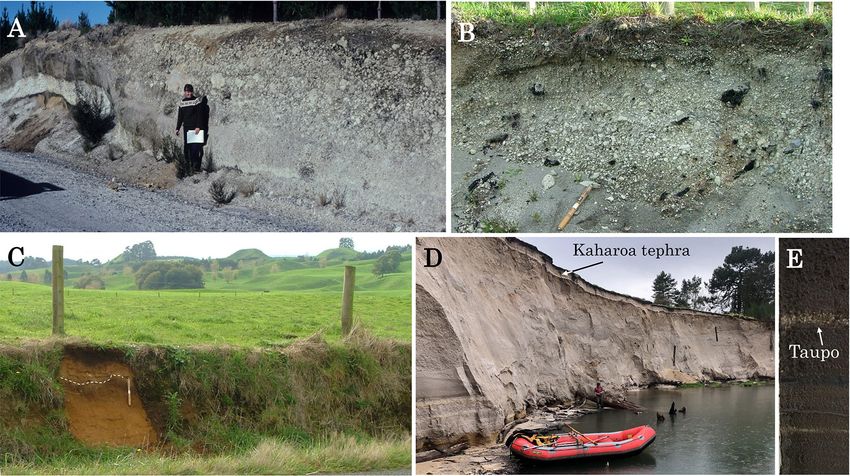
Key words:Taupō eruption, Taupō supervolcano, eruption Y, non-welded ignimbrite, low-aspect
ratio ignimbrite, inverse volcano, pyroclastic flow, density current, plinian, phrea-
toplinian, radiocarbon wiggle-matching, breakout flood, rhyolite, tephrochronology,
tephra, Vitrands, Pumice Soils, volcanic hazard, Taupō Volcanic Zone, gullying,
cobalt deficiency, plantation forestry
I. Introduction
Taupō caldera volcano comprises a complex of
large caldera and fault structures in the central
part of the Taupō Volcanic Zone(TVZ) (Figs.
1 and 2). The most frequently erupting and
productive rhyolite volcano on Earth(Wilson
et al., 2009) , Taupō supervolcano is submerged GMT
by Lake Taupō, the largest fresh-water lake
Fig. 1 Locality index of Taupō volcano, Aotearoa New
in Australasia. The volcano is an archetypal Zealand.
inverse volcano, which are concave with the
‘flanks’ sloping gently inwards towards the vent
locations(Walker, 1981a, 1984). It overlies a the wide east-west ovoid basin that forms the
very large silicic magmatic system(Barker et northern part of Lake Taupō today (Wilson,
al., 2021) . Volcanic events have been so volumi- 2001) (Fig. 2). The lake’s southern basin is a
nous and explosive, and the eruptives dispersed syn-eruptive volcano-tectonic collapse structure
so widely, that the accumulation of material relating to the Ōruanui eruption (Davy and
around the vents has not compensated for col- Caldwell, 1998; Wilson, 2001; Allan et al., 2012;
lapse associated with caldera formation(Wilson Barker et al., 2021)
.
and Walker, 1985; Barker et al., 2021). Conse-
II. Taupō eruption and its products
quently, the bed of Lake Taupō in the vicinity
of Horomatangi Reefs near the eastern shore The ~AD 232 Taupō eruption, known as
(Fig. 2), at a depth of 185 m, is the lowest point eruption Y in the post-Ōruanui stratigraphic
in the landscape for over 40 km in any direc- sequence erected for Taupō volcano by Wilson
tion(Grange, 1937; Froggatt, 1979; Lowe and (1993) , was one of the most violent and com-
Green, 1992; Wilson, 1994). plex rhyolite eruptions in the world in the past
The Taupō eruption, which took place in AD 5000 years(Wilson and Walker, 1985; Barker
232 10(see Section V below), was the latest et al., 2016). The second or third largest erup-
of 27 eruptions to have taken place at Taupō tion globally in the past 2000 years, the Taupō
volcano since the Ōruanui super-eruption occurr- eruption is unique in the post-Ōruanui sequence
ed c. 25,400 calendar(cal.)years BP(Wilson, in that it generated new caldera collapse, and
1993, 2001, 2008; Houghton et al., 2010; Allan its volume greatly exceeds(by about five times)
et al., 2012; Vandergoes et al., 2013; Dunbar et those of any of the preceding(post-Ōruanui)
al., 2017) . Also known as the Kawakawa event, eruptives (Barker et al., 2021) . The Taupō
the Ōruanui eruption was extremely volumi- eruption was centred on at least three vents on
nous with a total magma volume of ~530 km3 a northeast-southwest aligned fissure in the
(equivalent to ~1170 km3 as bulk pyroclastic vicinity of the Horomatangi Reefs within east-
material)(Wilson, 2001). Caldera collapse ern Lake Taupō(Fig. 2) (Smith and Houghton,
associated with this huge eruption generated 1995a; Houghton et al., 2003, 2010) . The erup-
― 118 ―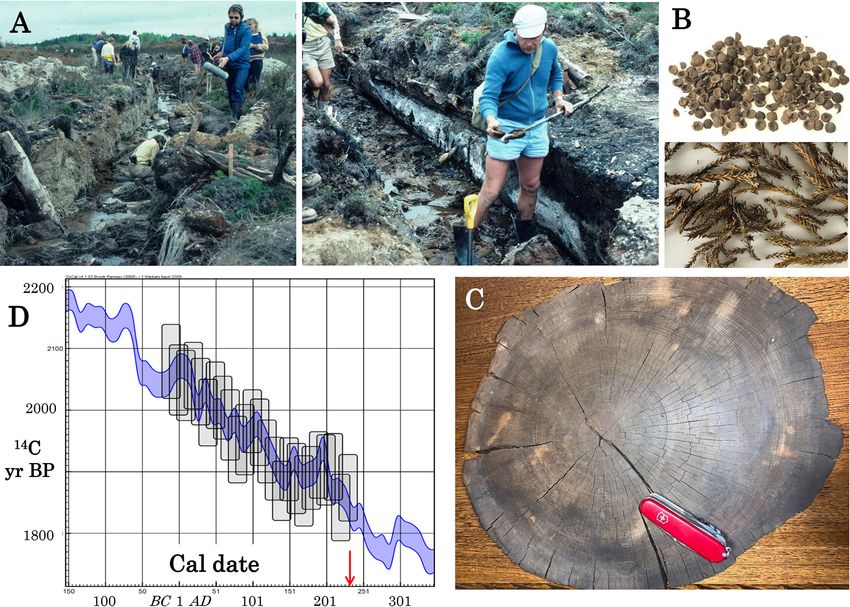
Fig. 2 Map of the central North Island showing the distribution of pyroclastic eruptives from the Taupō eruption(of AD
232 10)comprising the tephra-fall deposits combined and the non-welded Taupō ignimbrite(after Wilson and
Walker, 1985). Their source is the Taupō vent lineament now submerged in Lake Taupō near the subaqueous
rhyolite domes of Horomatangi Reefs(HR)and Waitahanui Bank(WB) (Smith and Houghton, 1995a, 1995b;
Houghton et al., 2010; von Lichtan et al., 2016). The lake occupies a caldera formed by the Ōruanui eruption c.
25,400 cal. yr BP: OSC, Ōruanui structural caldera; OCC, Ōruanui collapse collar(Wilson et al., 2006; Barker et
al., 2016, 2019, 2021). Inset shows the plate tectonic setting of North Island(Leonard et al., 2010)
. The(Young)
Taupō Volcanic Zone(TVZ), similar in size to the Yellowstone system but more productive(Houghton et al.,
1995), is divided into a central rhyolitic part(R)flanked by zones dominated contrastingly by andesitic strato-
volcanoes(A) (Wilson et al., 1984, 1995; Wilson and Rowland, 2016).
tion has been divided into seven contrasting divided into units Y1 to Y7 followed by a sep-
phases, each of which generated diverse, but arate event denoted as eruption Z, namely the
overwhelmingly pyroclastic, eruption products. subaqueous growth of lava domes(which gen-
The products have been given both stratigraph- erated large floating blocks)(Wilson, 1993).
ic names and equivalent unit designations, Y1 However, Houghton et al.(2003)revised the
to Y7(Fig. 3). Prior to 2003, the eruption was stratigraphic associations as follows:(i)erup-
― 119 ―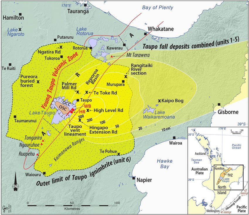
Fig. 3 Summary of the stratigraphy of deposits of the Taupō eruption(Unit Y)showing both stratigraphic names and
volcanological unit designations(after Wilson and Walker, 1985; Houghton and Wilson, 1986; Houghton et al.,
2003, 2010) . Facies of Taupō ignimbrite are also shown: Layer 1, facies H and P; Layer 2, facies VPI, valley-
ponded ignimbrite; IVD, ignimbrite veneer deposit; and DF, distant facies. Unit 7 comprises giant floated pum-
iceous blocks derived from subaqueous lava domes. Most symbols represent pumiceous clasts of varying grain
size; solid symbols denote lithics(± crystals) . Graphs at right indicate semiquantitative changes in the inferred
degree of magma-water interaction and the magma discharge rate(which becomes extreme before and during
emplacement of unit 6, Taupō ignimbrite) . E and S denote, respectively, erosional horizons formed by running
water (E) or shearing (S) beneath the fast-moving pyroclastic flow that deposited the non-welded Taupō
ignimbrite(after Walker, 1981c; Houghton and Wilson, 1986; Wilson, 1994; Houghton et al., 2003, 2010).
tion Z was re-designated as the final effusive around 1000 years, the earliest Polynesian sea-
dome-growing stage, Y7, of the Taupō eruption farers arriving around AD 1280, a few decades
sequence; (ii) the original units Y5 (Taupō before the Kaharoa eruption of AD 1314 12
plinian pumice)and Y6(early ignimbrite flow (Hogg et al., 2003; Wilmshurst et al., 2008;
units)were re-designated as units Y5a(Taupō Lowe, 2011; Lowe and Pittari, 2014). Conse-
plinian pumice)and Y5b(intra-plinian ignimb- quently, the Taupō pyroclastic deposits provide
rite flow units), respectively; and(iii)the orig- an isochronous tephrochronological benchmark
inal unit Y7 was re-designated as Y6(Taupō well before any human arrival and impacts
ignimbrite). The current stratigraphic names (Lowe et al., 2000, 2002; Lowe and Newnham,
and units, used throughout this article, follow 2004) .
Houghton et al. (2003, 2010) and are sum- The eruption sequence consists of five explo-
marised in Fig. 3. We mainly use the term pyro- sive phases, two of them ‘wet’ or phreatomagma-
clastic(‘fiery fragments’)rather than tephric, tic (i.e. involving magma-water interactions)
its near synonym(Lowe, 2011), because of the and three ‘dry’ or magmatic (i.e. driven by
volcanological focus of this paper. expansion of internal volatiles) , that deposited
We note that the Taupō eruption pre-dates pyroclastic fall deposits(denoted as units Y1 to
human arrival in Aotearoa New Zealand by Y5), followed by the sixth and climactic plinian,
― 120 ―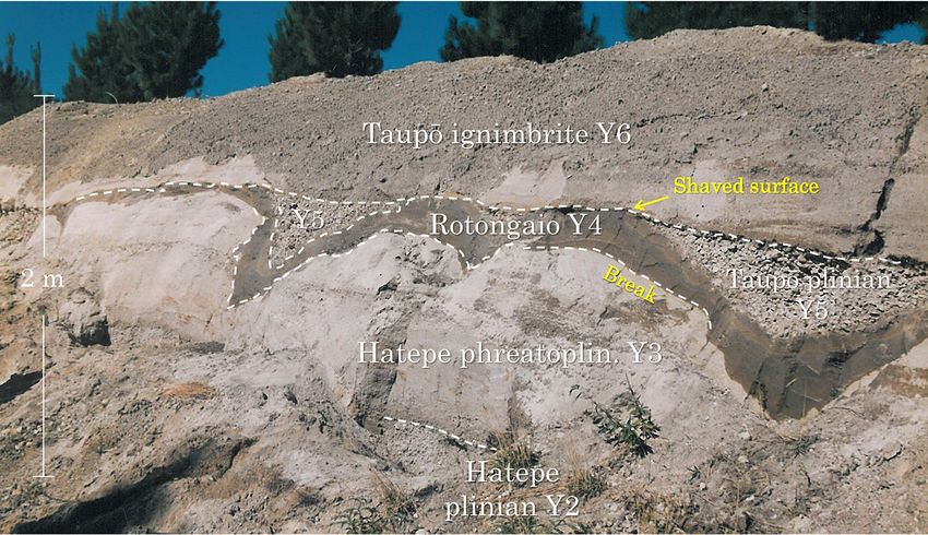
caldera-forming event that resulted in the sub-      (Fig. 5)on which the location of the section at
sequent emplacement of the non-welded Taupō           High Level Road(Fig. 4)is denoted by a grey
ignimbrite(unit Y6)    (Fig. 3). After some years     star.
or a decade or so, lava was extruded on to the           2-1)Phase 1
bed of the reconfigured Lake Taupō, forming               The eruption began with relatively minor
subaqueous domes comprising Horomatangi               phreatomagmatic activity, with cold lake water
Reefs and Waitahanui Bank (Fig. 2). Large             mixing with hot magma to generate the fine-
pumiceous blocks(forming unit Y7)broke away           grained Initial ash(unit Y1)over a period of a
from the dome carapaces and floated to the lake        few hours, and from an eruption column ~10 km
surface before being driven ashore at multiple        high(Wilson and Walker, 1985)       , so that the
sites on the eastern side of the lake at levels       distribution is relatively localised(Fig. 5). The
up to 10 m higher than those of today(Wilson          volume of phase 1 eruptives is estimated to be
and Walker, 1985; Smith, 1991; Wilson, 1993;          ~0.05 km3 as loose material(Wilson, 1993).
Manville et al., 1999; von Lichtan et al., 2016).        2-2)Phase 2
   The eruption pyroclastic fallout deposits grea-       The Hatepe plinian deposits(unit Y2)repre-
ter than 10 cm in thickness cover ~30,000 km2        sent a change to largely magmatic activity and
of land in the eastern North Island and the ig-      a step-up in eruption intensity, expressed as
nimbrite covers a near-circular area of ~20,000      mass eruption rate(Fig. 3), so that an eruption
km2(Fig. 2). The fall deposits from the erup-        column ~30 km high was formed and the air-
tion comprise one of the most varied sequences       borne pyroclasts were blown over considerable
yet described from a single eruption episode,        distances(Fig. 5)   (Wilson and Walker, 1985)    .
and the emplacement of the Taupō ignimbrite          Early dilute density currents and minor late-
is regarded as the most violently emplaced pyro-     stage pyroclastic flows(density currents)were
clastic flow deposit yet recorded(Wilson and          also generated(Talbot et al., 1994; Houghton et
Houghton, 2004)    . Barker et al.(2021)noted        al., 2010) . The fall deposits are faintly bedded
that the Taupo eruption pyroclastic deposits         although appearing to be uniform and well
are regarded as type examples globally because       sorted and represent an average, moderately-
of their widely varying eruptive styles.             sized plinian eruption(Walker, 1981b)with an
   The total volume of the Taupō eruptives is        estimated volume of ~2.5 km3 as loose material
at least 35 km3 as magma, equivalent to ~105         (Wilson, 1993)   .
km3 of bulk pyroclastic material, a figure that           2-3)Phase 3
includes co-ignimbrite ashfall and material              The Hatepe phreatoplinian ash(unit Y3)is
beneath the waters of Lake Taupō(Wilson and           a predominantly fine-grained, crudely bedded
Walker, 1985; Wilson, 1993).                          deposit that is putty-like when wet, and it read-
   1)Significant exposure: Taupō eruptives             ily becomes sensitive or thixotropic (Walker,
      Y2 to Y6 at High Level Road section,            1981c) . Rich in fine-grained, highly-vesicular
      east Taupō                                      pumice clasts, the eruption marks a period
   Five of the Taupō eruptive units are exposed       when vent-widening allowed abundant external
at a spectacular section on High Level Road           water, including lake water, to gain access to
east of Lake Taupō, ~20 km from the vent(Fig.         the rising and erupting gas-charged magma.
2). The section is shown in Fig. 4.                   In addition, steam would have been generated
   2)Taupō eruption sequence phase by                 in substantial amounts, condensing to produce
      phase                                           rain, which flushed ash out of the eruption
   The Taupō eruption in its entirety lasted be-      column/plume so that it fell as wet sticky mud,
tween several days and several weeks(Wilson           being found draped over branches of shrubs or
and Walker, 1985)    . The dispersals of eruptives    trees preserved in the deposits(Walker, 1981c;
generated by each phase are shown on six maps         Smith and Houghton, 1995b; Wilson and Hough-

                                                ― 121 ―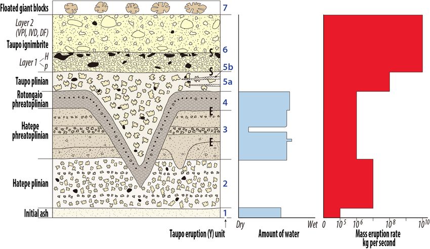
Fig. 4    Section on High Level Road(Fig. 2)showing contrasting pyroclastic deposits of the Taupō eruption including
           both ‘wet’ and ‘dry’ fallout deposits(units Y2 to Y5)and unconsolidated Taupō ignimbrite(unit Y6). The Hatepe
          (Y2)and Taupō(Y5)plinian materials are notably coarser than those of the two fine-grained phreatoplinian
          events(Y3 and Y4), with the coarsest deposits of Taupō plinian attesting to the extreme power of the Y5 phase of
           the eruption. The ‘break’ refers to a period of possibly hours to fewer than about three weeks in duration(Walker,
           1981c; Wilson and Walker, 1985; Wilson, 1993)during which pre-existing Hatepe phreatoplinian deposits(Y3)
           were eroded by erupted lake water, probably together with runoff from rainstorms, into shallow gullies or rills
           so that the subsequent fine-grained mantling deposits of the Rotongaio phreatoplinian deposits(Y4)form a
           striking V-shaped pattern. Smith and Houghton(1995a)argued, however, that there was essentially no break
           between the emplacement of Y3 and Y4. An earlier erosional event took place during the Hatepe phreatoplinian
           phase(Y3), although the shallow gullies generated by it(cut into Y2)are not as conspicuous(Walker, 1981c;
           Fig. 3). At the top of the section, the emplacement of the Taupō ignimbrite(Y6)by the unrestrained pyroclastic
           flow has shaved of most of the Y5 deposits except where they were protected in the erosional gullies(Houghton
           and Wilson, 1986). Site location: 38°47¢56²S, 176°15¢21²E. Photo: D.J. Lowe.

 ton, 2004) . Phase 3 was interrupted at least                    which are uncertain. Estimates for the more
 once by a brief return to ‘dry’ plinian activity,                prominent break at the end of phase 3 range
 represented at the High Level Road section by                    from hours to fewer than about three weeks
 a ~5 cm-thick pumice lapilli bed within unit Y3                 (Walker, 1981c; Wilson and Walker, 1985;
(Fig. 3). The phreatomagmatic eruption, which                     Wilson, 1993), although Smith and Houghton
 endured for a few to tens of hours(Wilson and                   (1995a)contrarily suggested that there was no
 Walker, 1985) , has been described as a typical                  significant time break between phase 3 and the
 or even archetypal phreatoplinian event(Smith                    ensuing phase 4. During the break at the end
 and Houghton, 1995a; Kósik et al., 2019). Its                    of phase 3, or during a period when phases 3
 products were blown eastwards(Fig. 5). Their                     and 4 were erupting simultaneously from two
 volume is estimated to be ~1.9 km3 as loose                      different vents (see Fig. 5)   , intense rainfall
material(Wilson, 1993).                                           resulted in the formation by erosion of shallow
   During, and immediately after, the phase 3                     gullies or rills, about 1 m in depth on average,
eruption, two breaks involving deposit erosion                    in tephra deposits east of Lake Taupō(Walker,
may have occurred(Fig. 3)     , the durations of                  1981c) . The rainfall was derived from either

                                                          ― 122 ―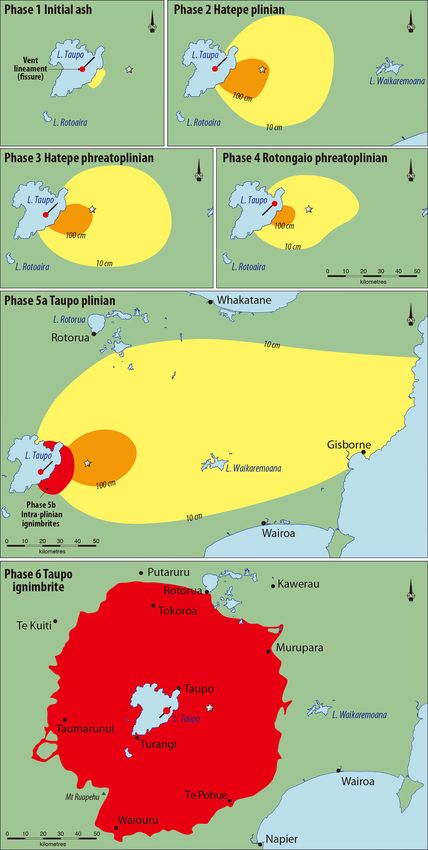
voluminous ejected water or condensate from denoted as unit Y5b (Fig. 5), both proximal
steam from Lake Taupō itself, or from a common (weakly-emplaced, metre-thick) and distal
meteoric storm, or both. The gullies deepen (energetically-emplaced, decimetre-thick)depo-
closer to Lake Taupō, where they may be 2 m sits associated with partial collapse of the plin-
or more deep (Walker, 1981c). Gullies that ian column or relatively gentle overflow from
were probably formed to the south are inferred the vent (Wilson and Walker, 1985; Wilson,
to have been removed by severe erosion during 1993; Houghton et al., 2010) . The majority of
very intense rainfall, that water deriving the pumice was blown eastwards across the
ultimately from lake water near the vent that country and well beyond Hawke’s Bay into the
was jetted into the eruption plume(Smith and Pacific Ocean. As well as this extreme disper-
Houghton, 1995a) . sal, the plinian fall deposits (Fig. 6), which
2-4)Phase 4 have a maximum observed thickness of only
The renewal of the eruption resulted in the 2.1 m, show a very slow rate of thinning with
deposition of the Rotongaio phreatoplinian ash distance from vent, the slowest yet recorded for
(unit Y4)as a consequence of abundant lake a ‘dry’ fall deposit(Wilson, 1993) .
water encountering a shallow subaqueous dome These features─the wide dispersal, high
of dense, degassed magma that was exposed by magma eruption rate, and extreme eruption
the opening of a new vent to generate a dark- style─led Walker(1980)to describe the Taupō
grey, very-fine-grained obsidian-rich ash that, eruption(phase 5a)as ‘ultraplinian’, a new and
like Y3, landed wet(Houghton et al., 2003; Wil- unique end-member class at the time. He sug-
son and Houghton, 2004). It infilled the eroded gested that such a powerful eruption, which he
gullies to form a very distinctive V-shaped layer estimated as lasting between six and 17 hours,
in the sequence(Figs. 3 and 4) . The Rotongaio would have generated an eruption column 50
phreatoplinian ash is markedly fine grained 55 km high, at the theoretical limit. However,
with little material coarser than 1 mm, even Wilson and Walker(1985)estimated an erup-
in the most proximal exposures(Kósik et al., tion column 30 to 40 km in height, and Hough-
2019), and the unit contains numerous intra- ton et al.(2014)suggested that a column 35 to
formational rills, some on a scale of 3 to 10 40 km high─still at the top end of the plinian
cm and others 40 cm wide and 30 cm deep, range(Trolese et al., 2109)─was likely. Phase
produced by syn-eruptive erosion(Smith and 5a of the eruption generated ~7.7 km3 of loose
Houghton, 1995a) . An erupted volume, as loose material (Wilson, 1993)(a larger volume of
material, for the unit is estimated at ~1.1 km3 23 km3 was estimated, using a mass-balance
(Wilson, 1993). method, by Walker, 1980) , and phase 5b has
2-5)Phase 5 an estimated volume, as loose material, of ~1.5
The fifth event in the sequence, Taupō plinian km3(Wilson, 1993) .
(Y5), saw an abrupt switch to a ‘dry’ and extre- 2-6)Phase 6
mely powerful, magmatically-driven eruption, The sixth and climactic phase of the Taupō
generating a towering column about 35 to 40 eruption was the extremely violent emplace-
km high(Houghton et al., 2014)that deposited ment of the Taupō ignimbrite, the product of a
vesicular pumice over a very wide area, denot- hot, excessively fast-moving, ground-hugging
ed unit Y5a(Fig. 5). The eruption intensity pyroclastic flow(within the spectrum of pyro-
reached near-extreme values with magma dis- clastic density current types) formed by the
charge between 8 ´ 104 to 2.4 ´ 105 m3 s (ap-
-1
catastrophic collapse of the plinian column of
8 -1
proximately 10 kg s : Houghton et al., 2003, phase 5a. As well as vent widening and ground
2010) (Fig. 3). At least 11 modest- or small- subsidence, generating a new caldera manifest-
volume, intra-plinian pyroclastic flow deposits ed as a sub-rectangular basin within the older
(density currents) were erupted co-evally, Ōruanui collapse structure(Davy and Caldwell,
― 123 ―Fig. 5 ― 124 ―
1998; Manville et al., 1999), the column collapse m high, including Tongariro(1978 m above sea
was caused by a drastic change in eruption level, asl)and high peaks on the Kaimanawa
conditions. The inferred extremely high dis- Range(up to 1727 m asl), with only Ruapehu
charge rate of 108 to 7 ´ 1010 kg s (Fig. 3) (2797 m asl)high enough to block it(Figs. 2
-1
was much greater than that capable of forming and 5) . Large-scale laboratory simulations and
a stable plinian column(Wilson and Walker, modelling have recently shown that pyroclastic
1981, 1985; Houghton et al., 2003, 2010; Trolese flows generate their own air lubrication, form-
et al., 2019) . From modelling, Dade and Hup- ing a near-frictionless basal region displacing
pert(1996)suggested that the rate of magma particles upwards, thereby allowing huge mass-
es(thousands to millions of tonnes)of material
-1
discharge was 5 ´ 107 m3 s . They calculated
the temperature of ejecta in the eruption column to be transported over uneven and upsloping
-1
was 700°C, the vertical velocity was 300 m s , terrains such as that in central North Island
and that the vent had a radius of almost 1 km (Lube et al., 2019) .
(see also Dade and Huppert, 1997; Wilson, During its passage the pyroclastic flow con-
1997). sisted of a head, strongly fluidized by ingested
The pyroclastic flow was so energetic, in part air and the near-frictionless basal zone, which
because of the extreme explosivity of the erup- generated layer 1 deposits, and a body plus tail,
tion, that it travelled radially outwards from which generated layer 2(Fig. 6; Wilson and
Lake Taupō at speeds of around 200 to 300 Walker, 1985) . Layer 1 comprises two facies,
m s (approximately 600 to 900 km h ), or
-1 -1
a pumice-rich facies P, termed jetted deposits,
greater near vent, for about 80 ± 10 km in all which are overlain by a dense, lithic- and
directions(Wilson and Walker, 1982; Wilson, crystal-rich facies H, termed the ground layer
1985, 1993; Dade and Huppert, 1996). The (Walker et al., 1981a, b; Wilson, 1985) . Layer
velocity remained high(> 100 m s )towards
-1
1 deposits underlie layer 2, which consists of
the outer limits of the flow. From ~40 km out- mainly pumiceous materials dominated by
wards the flow was a single wave of material coarse clasts(lapilli, blocks)and abundant fine
and it stopped only when the material ran material(ash) (Fig. 6) . As noted further below,
out(Walker et al., 1981b; Wilson and Walker, layer 2 is manifested as two pumiceous facies:
1985). The pyroclastic flow, with a volume of valley-ponded ignimbrites and ignimbrite veneer
~30 km3(as loose material) , covered an area of deposits(Walker et al., 1981b; Wilson, 1985).
20,000 km2 in around 400 seconds(7 minutes) In many places, layer 1 is depleted in fine ma-
(Wilson and Walker, 1985). Dade and Huppert terial, described as fines-depleted ignimbrite,
(1996)suggested from an isothermal hydraulic its turbulent emplacement and ingestion of
model that the entire emplacement took no timber(see below)likely leading to the deple-
more than 15 minutes. The high speed and tion of finer vitric constituents so that it is
fluidity gave the flow sufficient momentum to clast-supported for all clasts exceeding ~2 mm
allow it to easily surmount mountains > 1500 in size(Walker et al., 1980b; Wilson and Walker,
Fig. 5 Maps showing the distribution of the pyroclastic fall and flow deposits that were emplaced during the six explo-
sive phases of the Taupō eruption(Fig. 3). The maps are based mainly on Wilson and Houghton(2004) . Maps
14 have the same scale. The positions of three recognised vents(red dots)lying on the 9-km-long NESW
fissure or lineament in Lake Taupō are based on Wilson(1993), Smith and Houghton(1995a) , and Houghton
et al.(2003). The grey star marks the location of the section shown in Fig. 4. In terms of hazards, the yellow
zones received 10 to 100 cm of fall deposits, which would destroy roofs on most houses, especially if wet. The
orange zones received > 100 cm of fall deposits, which would be uninhabitable. The red zones were covered by
ignimbrite, and the pyroclastic flows that emplaced them would have destroyed all life and structures in their
path. For a more sophisticated analysis of potential ash-dispersal-related hazards, see Barker et al.(2019).
― 125 ―Fig. 6 Upper photo. Typical subdued(gently rolling to flat or undulating)Taupō-eruptive-mantled landscape of the
central TVZ, viewed looking west along Te Toke Road, with steep rhyolite domes in far distance. The pit was
excavated on near-flat ground to the far right on farmland(Endeavour Farm), ~30 km north of the vent(Fig. 2).
The two main land uses for these glassy pumiceous soils are evident: agriculture and plantation forestry. Lower
photo. The base of the section comprises three pre-Taupō tephras and associated paleosols(Wilson, 1993) : unit S,
Waimihia(3382 ± 50 cal. yr BP) ; unit V, Whakaipo(2800 ± 60 cal. yr BP) ; and unit X, Mapara(2059 ± 118 cal.
yr BP) (ages from Lowe et al., 2013). These beds are overlain by three thin( 5 cm)early Taupō-eruption units
Y2Y4. In turn, Y4 is overlain by ~0.7 m of Taupō plinian deposits(unit Y5), above which is ~1.2 m of Taupō
ignimbrite(unit Y6)with the contrasting lithologies of layers 1 and 2 clearly expressed. Layer 1(mainly facies
H, a fines-depleted ground layer)is so loose that parts of the pit wall at left have fallen down. Layer 2 represents
the IVD facies. Pedological horizonation is also shown(based on Clayden and Hewitt, 1994)and the young soil’s
classification is given in Section IV. Section-tape units are decimetres. Site location: 38°34¢29²S, 176°14¢28²E
(nearby road cuttings show similar features) . Photos: D.J. Lowe.
1985). The properties of layer 2 show a wide are often very fine grained and almost wholly
spectrum of lateral variants(Wilson and Walker, pumiceous and, moreover, contain very low-
1985): proximal deposits are coarse grained, density pumice. The differing lateral variations
with large lithic clasts, whereas distal deposits are mainly a result of the upward movement
― 126 ―of fine, light, dominantly pumiceous material and spread over the landscape as the flow ran
within the flow in response to strong fluidiza- out of material while still retaining a high velo-
tion, and the unfurling of the flow because of its city(Wilson and Walker, 1982; Wilson, 1985) .
extreme violence so that the upper parts of the The ignimbrite covered a near-circular area
flow travelled the farthest(Walker and Wilson, and reached about the same distance after
1983; Wilson, 1985; Wilson and Walker, 1985) . crossing several substantial mountain ridges
The emplacement of the Taupō ignimbrite re- as it did after travelling in other sectors over
sulted in sudden and dramatic changes to large nearly level ground (Wilson, 1985) . Rather
parts of the central North Island landscape. than piling up around the vent(like the prox-
The pre-ignimbritic fall beds(units 15)had imal early flow units of phase 5b)to generate
blanketed the antecedent land as a landscape- a clearly defined ignimbrite surface, the Taupō
modifying(i.e. mantling)event, making it smoo- ignimbrite to a large extent drapes the pre-
ther. In contrast, the emplacement of the Taupō existing landscape and in places superficially
ignimbrite was primarily a landscape-forming resembles a fall deposit(Fig. 7C; Wilson and
event in that the flows infilled valleys(includ- Walker, 1985) . The IVDs on high points in
ing deposits, left behind from the flow body, the landscape mimic the effect of fall beds in
partially draining back into valleys) and generally smoothing(rounding)the landscape
blocked them off, destroying surface hydrologic contours(Healy, 1967) .
networks(Wilson, 1985; Manville et al., 1999). Various other volcanological features relating
Taupō ignimbrite is thus thicker in valleys, to the ignimbritic deposit, which are every-
forming the valley-ponded ignimbrite deposits where non-welded, include the deposition of
(VPIs)between ~1 and 70 m deep, typically jetted deposits that represent layer 1(P)facies
³ 5 m, and with flat to gently undulating sur- (jets of material thrown forward supersonically
faces(Fig. 7A) (Walker et al., 1981b; Wilson, from the advancing wave-like front of the flow
1985; Manville et al., 2009) . The thicknesses of head as a result of the violent expansion of
the VPIs are independent of the distance from ingested air) , and in places the flow tore up
vent(Wilson and Walker, 1982, 1985). As the or overturned parts of the underlying soil and
flow crossed topographic highs, climbing slopes incorporated them into the ignimbrite as rip-up
as steep as 30°, it emplaced thin ignimbrite- clasts as well as scalping the antecedent Taupō
veneer deposits(IVDs) , 0.25 to 8 m deep, typi- plinian deposits of phase 5a(Fig. 4) (Wilson,
cally 0.5 to 2 m in thickness(Fig. 7A) (Walker 1985; Wilson and Walker, 1985). Many of the
et al., 1981b; Wilson and Walker, 1985) . The large pumice clasts are notably rounded because
IVDs systematically decrease in thickness with of transport in a pyroclastic flow. In the fall
distance from vent, with distal deposits(> 40 deposits, the size of the pumice clasts generally
km from vent) effectively comprising a con- decreases with distance from the eruption
tinuous IVD(Walker et al., 1981a, b; Wilson source(those of the Taupō plinian phase being
and Walker, 1981; Wilson, 1985). Walker et al. exceptionally slow to diminish, as noted ear-
(1981b)described the IVD as a deposit from lier)while the proportion of fine-ash particles
a pyroclastic flow, recording its passage as a typically increases with distance from source.
‘trail-marker’ while the flow has continued on, Pumice clasts in the pyroclastic flow deposits,
whereas the VPI is the trailing part of the body however, show a complex relationship of size
of the flow itself that has come to rest. with distance from source that depends on the
The distal deposits(termed the distant facies, source of the deposit: clasts in the IVDs(on
DF)represent the lateral equivalent of layer ridge tops)decrease in size away from source
1(P)and layer 2 on distant interfluves(Fig. but those in the VPIs(in antecedent valleys)
7C), and are interpreted to be flow-head and remain uniform or increase slightly in size
flow-body material that was mixed together away from source to about 40 km from vent
― 127 ―Fig. 7 A. Exposure of Taupō ignimbrite on Hingapo Extension Road, 19 km southeast from vent(Fig. 2), showing two
facies: at right is a valley-ponded ignimbrite(VPI) (> 3 m thick)which morphs laterally to the far left into an
ignimbrite-veneer deposit(IVD)overlying a pre-ignimbrite paleosol(marked by the yellow-brown soil under
the white pumice)on a low hill(see Wilson, 1985, plate 6: Fig. 34a) . The VPI contains a coarse-grained pumice
concentration zone overlain by fine deposits ~0.5 m thick(darkened zones)at the land surface(Houghton and
Wilson, 1986). Site location: 41°25¢38²S, 172°08¢47²E. Photo: D.J. Lowe. B. Taupō ignimbrite(Y6)exposed on
Palmer Mill Road, ~25 km north of vent, showing abundant charcoal and carbonised logs. Cutting tool is 30 cm
long. Site location: 38°35¢15²S, 176°04¢40²E. Photo: D.J. Lowe. C. Pumice-dominated, distant-facies deposit of
non-welded Taupō ignimbrite(above the dashed line)in a gently rolling to hilly landscape on Ngatira Road near
Lichfield, ~75 km north of vent and barely 5 km from the flow’s outermost margin(Fig. 2). The steeper hills and
semi-continuous plateaux in far background comprise much older welded ignimbrite sheets ~1 Ma in age that
have been partly dissected by erosion(Lowe and Pittari, 2019) . The Taupō ignimbrite is ~0.5 m thick and is
underlain by a buried paleosol on multiple thin pre-Taupō eruptives. Scattered fine pumice lapilli at the base of
the ignimbrite may represent Taupō plinian material(Y5a). Cutting tool is 30 cm long. Site location: 38°06¢28²S,
175°49¢29²E. Photo: D.J. Lowe. D. Thick(~9 m)pumice-rich fluvial deposits mainly comprising debris flow and
hyperconcentrated flow materials emplaced within a few years of the Taupō eruption(Manville et al., 1999,
2005, 2009) , and exposed alongside the Rangitāiki River near Murupara(Fig. 2)in the Galatea depression.
The fluvial deposits overlie a remnant buried forest(note in situ stumps and logs at river level)and are capped
by bright-white rhyolitic Kaharoa tephra-fall materials erupted from Mt Tarawera in AD 1314 ± 10(Hogg et
al., 2003). Site location: 38°25¢40²S, 176°42¢7²E. Photo: E. Smeith. E. Photo showing ~5 to 10-mm-thick layer of
fine lapilli/coarse ash of the Taupō eruption, possibly representing deposition of co-ignimbrite fallout material,
preserved in dark organic rich lake sediments in Lake Ngaroto, near Hamilton(Fig. 2), and ~110 km northwest
and ‘upwind’ from the vent(Lowe, 1988). Site location: 38°57¢12²S, 175°17¢20²E. Photo: D.J. Lowe.
until decreasing beyond 60 km from vent scape with an average thickness of about 1.5 m
(Wilson, 1985). (Walker et al., 1980b), only being broken where
The extreme violence and fluidity of the locally cut by later erosion (Walker et al.,
relatively dilute Taupō pyroclastic flow caused 1981b) . Such a thin but widespread sheet is
the ignimbrite to be spread as an effectively referred to as a low-aspect-ratio ignimbrite, the
continuous but thin sheet over the entire land- aspect ratio being the vertical dimension divid-
― 128 ―ed by the horizontal dimension─in this case hugged the lower ground, and accompanied pe-
~1: 100,000(Walker et al., 1980a; Walker and riodic explosive eruptions of great magnitude’
Wilson, 1983) . Despite its thinness and thus (p.122) . Terms such as ‘ash flows’, ‘huge nuées
innocuous appearance, the Taupō ignimbrite ardentes’, and ‘glowing avalanches’ were also
reflects the most extreme of dangers in the used in the 1950s60s to describe the origin of
spectrum of volcanic hazards(Walker, 1980) the uppermost deposit (e.g. Baumgart, 1954;
as a function of its very high mobility and heat Baumgart and Healy, 1956; Healy, 1965, 1967).
(Breard et al., 2019). Because of its violence Gibbs(1968)described the final Taupō erup-
and energy release(³ 150 ± 50 megaton TNT tives as originating from ‘extremely hot clouds
explosive yield, cf. Hiroshima bomb 0.015 Mt) , of material [that] were blasted across the land,
and by analogy with the AD 1883 Krakatau burning vegetation and sweeping logs, soil, and
eruption episode, it is probable that the Taupō ash into depressions’ (p.10) . Estimates from
ignimbrite-emplacement phase generated a charring experiments by Hudspith et al.(2010)
volcano-meteorological tsunami(essentially the and from thermal remanent magnetic work
collapsing eruption column displaced a large by McClelland et al. (2004) indicate the ig-
volume of air laterally, forming pressure waves) nimbrite’s temperature was 400 to 500°C at
that may have reached coastal areas worldwide sites beyond 40 km from vent, and 150 to 300°C
(Lowe and de Lange, 2000). at sites within 30 to 40 km of the vent. Beyond
The Taupō pyroclastic flow engulfed and car- the zone of ignimbrite emplacement, forests
bonised an entire forest, ingesting about 1 km3 located up to 170 km east of the vents were
of timber in total(Hudspith et al., 2010), and damaged to a varying degree by pyroclastic fall
charred logs and charcoal are ubiquitous in the deposits, and fires were evident during the erup-
ignimbrite(Fig. 7B). The carbonized logs have tion, continuing afterwards for several decades
been measured at up to 1 m in diameter close (Wilmshurst and McGlone, 1996; Horrocks and
to vents, and 5 m in length(Froggatt et al., Ogden, 1998) . Changes in forest composition
1981; Hudspith et al., 2010). The trees were before and after the eruption were also record-
broken off by the pyroclastic flow or preceding ed by Clarkson et al.(1995) .
blast, and then incorporated into the hot flow. Originally the term ‘ignimbrite’ (meaning
Their pattern of orientation radially around ‘fiery storm-clouds’), introduced by Marshall in
the eruption source vent provided a means of the 1930s(1932, 1935) , was associated by im-
mapping its position in the vicinity of the Horo- plication with hard(welded)rocks(Cole et al.,
matangi Reefs(Fig. 2; Froggatt, 1979; Froggatt 1972; Lowe and Pittari, 2019). It took many
et al., 1981). Further evidence was provided by decades for unconsolidated or non-welded pyro-
Walker(1980). Before then, the explicit vent clastic flow deposits to be recognised also as
position for the eruption had been uncertain, ‘legitimate’ ignimbrites, with Sparks et al.
with locations both in and beyond the lake (1973) providing the first definition to that
having been suggested(Froggatt, 1981a). As end. Walker(1980) , Walker et al.(1980a, b,
well, until the charcoal-bearing units were 1981b) , and Froggatt(1981a)were the first to
identified as a pyroclastic flow deposit(rather name the Taupō pyroclastic flow deposit specif-
than fall), it had been a puzzle as to how the ically as the ‘Taupō ignimbrite’, with Froggatt
deposit had remained so hot throughout its (1981a)summarising evidence for its flow origin
160-km-wide distribution (Grange, 1937). It in a 12-point list.
seems Baumgart and Healy(1956)were the The approximately equivalent Layer 2 and
first to infer that the uppermost part of the de- Layer 1 deposits were previously called ‘Upper
posit(‘Upper Taupo Pumice’) (Layer 2 today) Taupo Pumice’ and ‘Rhyolite Block Beds’, re-
originated from a primary pyroclastic flow that spectively(see Froggatt, 1981a, and Wilson and
was ‘laid down by glowing avalanches that Walker, 1985, for summaries of historical no-
― 129 ―menclature). range from ‘several years to a decade’ to possi-
2-7)Phase 7 bly 30 or 40 years: Wilson and Walker, 1985;
At some stage after the cessation of the Smith, 1991; Manville et al., 1999; Houghton et
climactic eruption of Taupō ignimbrite, possi- al., 2010; Barker et al., 2021) . Because of block-
bly after an interval of several years to a few age of its outlet, the new lake attained a mean
decades, rhyolite lava domes were erupted high-stand ~390 m asl, about 34 m above its
(extruded)onto the floor of the re-formed Lake present level(357 m asl), marked by a semi-
Taupō(Wilson and Walker, 1985)at a rather continuous wave-cut bench and shoreline de-
posits(Manville, 2002; Manville et al., 2007)
-1
modest magma discharge rate of ~103 kg s .
(Houghton et al., 2010). These domes are man- As the exit channel(Waikato River)was re-
ifested as the submerged Horomatangi Reefs established(see Section III below) , the lake fell
and Waitahanui Bank within the modern lake cataclysmically, forming a wave-cut bench at
(Fig. 2) , which together comprise a volume of 368371 m asl(i.e. ~5 m above present level)
0.28 km3(volume as lava: Wilson, 1993). The (Grange, 1937; Wilson and Walker, 1985; Man-
domes are draped in glassy pumiceous rhyolite ville et al., 1999, 2007) , the site on which the
debris(Wilson, 1993; von Lichtan et al., 2016) . giant floated pumices became stranded. Wilson
Scattered large pumiceous, glassy rhyolite and Walker(1985, p.213)described one such
blocks, of metre to decametre dimension, the block as coming to rest on post-Taupō-eruption
largest around 17 m in length, occur on a wave- lake sediments, slightly deforming them prior
cut terrace along the eastern shoreline ~5 m to being buried by younger sediments before
above present-day lake level. They are inferred the lake fell to its present-day position.
to have spalled from carapaces on one or more 3)Co-ignimbrite ash deposits
of the submerged rhyolite domes and then Co-ignimbrite ash deposits (equivalent to
floated ashore, being driven eastward by the layer 3 of Sparks et al., 1973)associated with
prevailing westerlies some time after the explo- the emplacement of Taupō ignimbrite have not
sive phases(Wilson and Walker, 1985; Wilson been commonly observed nor described, being
and Houghton, 2004; Barker et al., 2021). restricted to a few widely scattered outcrops
Palaeomagnetic measurements by von Lichtan beyond the outer limit of the ignimbrite(Wilson
et al.(2016)show that the giant blocks were and Walker, 1985) . Nevertheless, Manville
hot, above the Curie point, when they were (2002) and Manville et al. (2009) reported
gently emplaced, and the well-preserved chilled that, although volumetrically insignificant, the
contact and jointing features on them support co-ignimbrite layer, representing fallout from
this evidence(Barker et al., 2021) . The giant the elutriated-ash plume suspended above the
blocks became embedded in accumulating trans- pyroclastic flow, as well as distal remnants of
gressive shore-face sediments and continued the plinian eruption plume, and inferred to
cooling(von Lichtan et al., 2016) . The chemical have been deposited within a few hours of the
composition of lava from the Horomatangi emplacement of Taupō ignimbrite, is an im-
Reefs matches those of the Taupō eruptives and portant stratigraphic marker between syn- and
the floated giant blocks, confirming their coeval early post-Taupō eruptive reworking.
origins(Barker et al., 2015, 2021). Thin distal deposits in lakes and peats,
The floated blocks thus represent the young- such as shown in Fig. 7E, less than ~5 cm or
est material erupted(unit Y7)during the Taupō so in thickness and distributed well off the
eruption sequence(Fig. 3). Their grounding at strongly eastward-directed axis of the ³ 10-cm-
a lake level higher than that of today implies thick Taupō fall beds(Fig. 2) , may represent
that the lake must have refilled after the close co-ignimbritic ash fallout, as inferred by Lowe
of explosive activity, which would have taken (1988)for around six Late Quaternary tephra
possibly around ten to 30 years (estimates deposits in the Waikato region that are seeming-
― 130 ―ly thicker than the exponential would predict. Stage 0 is associated with the eruption itself
Pullar et al.(1977, p. 698)show a near-circular and emplacement of the successive fall beds and
5-cm-thick isopach of ‘Taupo Pumice’(centred the Taupō ignimbrite, the expulsion of water
approximately on Rotorua)that contrasts with from Lake Taupō, and the modification and for-
the west-east orientated fall-out isopach pat- mation of new landscapes, including landscape
tern of Wilson and Walker(1985). Barker et al. inversion and transformations of drainage, as
(2019)have modelled ash dispersal from radi- described earlier. Some remobilisation of pri-
ally expanding umbrella clouds, and concluded mary deposits would have occurred before depo-
that with increasing eruption size(using five sition of the co-ignimbrite ash layer(Manville,
scenarios, the Taupō event falling between sce- 2002) .
narios 3 and 4 with respect to magma volume) , Stage I is a period(spanning hours to a few
the formation of an umbrella cloud may propel years) of early remobilisation of the barren
significant amounts of ash upwind and cross- duvet of fine-grained, pumice-rich pyroclastic
wind as the cloud/plume becomes less sensitive deposits over an area > 20,000 km2(Fig. 2),
to the weather conditions as a result of the in- especially where the vegetation had been en-
creasing role of density-driven dispersal in the tirely destroyed or buried. Frequent rainstorms
plume. Such a scenario may help explain the would have caused intense erosion and depo-
pattern of fallout shown by Pullar et al.(1977) sition of the easily entrained loose and low-
and others for distal Taupō tephra deposits. density pumice materials(Selby and Hosking,
1973) , involving mainly mass flows, and rilling
III. Post-Taupō-eruption reworking
and gullying on slopes, with flash flooding
and impacts on landscape
generating downstream aggradation by debris
The immediate aftermath of the eruption and hyperconcentrated flow deposits(Manville,
would have seen erosion, secondary deposition, 2002) .
and reworking by water, wind, and gravity Stage II was a period of fluvial re-establish-
on a massive scale over large areas of central ment lasting several months to years, as upland
North Island and beyond. The rivers draining rill networks stabilised and sediment yields de-
the 160-km-wide zone around Taupō, choked creased as rills or gullies deepened sufficiently
with fall deposits and Taupō ignimbrite, acted to encounter soil-covered paleo-land surfaces
as major pathways for reworking and flooding with less-easily-eroded materials. Temporary
after the eruption(Wilson and Walker, 1985). lakes were formed, including the extensive
Using a combined stratigraphical, sedimentolog- supra-ignimbrite paleo-Lake Reporoa (in the
ical, and geomorphological approach, Manville Reporoa basin: Fig. 2), which formed in about
(2002)and Manville et al.(2009)described the three years and had a maximum area of ~190
landscape response to the Taupō eruption as a km2 and a volume of ~2.5 km3(Manville, 2001) .
distinct four-stage sequence(stages 0 to III), The lake would have emptied quickly after
but with overlap between each(i.e. post-erup- overtopping the barrier at its lowest point, near
tion stages I to III were diachronous)
. Although Orakei Korako, generating a peak flood dis-
-1
the general remobilisation pattern is similar charge of about 17,000 m3 s which contrasts
for all impacted river systems, the relative with the Waikato River flow rate through
the area today of ~130 m3 s (Manville,
-1
timing and extent of each response stage differ
for each of the Waikato, Rangitaiki, Mohaka, 2001) . Gullies deepened into box canyons in
Ngaruroro, and Whanganui catchments, reflect- the ignimbrite valley fill deposits (VPIs) via
ing differences in physiography and hydrology headward erosion (Healy, 1967) , and water
and the volume and type of pyroclastic material flow in shallow ephemeral streams, carrying
deposited in each (Segschneider et al., 2002; hyperconcentrated flows (e.g. Fig. 7D), became
Manville et al., 2009). permanent rather than episodic as sediment
― 131 ―loads declined so that the rivers became deeper therefore one of the most significant of volcanic
and braided, eventually (over years to de- hazards.
cades)returning to pre-eruption gradients and
IV. Formation of glassy soils on Taupō
bedloads(Segschneider et al., 2002; Manville,
eruptives and their special character
2002; Manville et al., 2009).
Stage III is the period beginning with the The soils formed in the unconsolidated rhyolit-
Taupō breakout-flood(initiated approximately ic Taupō eruptives, emplaced barely 1800 years
20 years after the eruption)through to the pre- ago, are youthful and only weakly weathered
sent day. As described above(section on phase with a low clay content(£ ~5%)in uppermost
7 of the eruption), blockage of the outlet gorge horizons, and most clay is allophane(Lowe and
of the Waikato River by a natural dam 30 to 40 Palmer, 2005; McDaniel et al., 2012) . Their
m high, comprising non-welded pumiceous pyro- main physical properties tend to be dominated
clastic deposits(remnants of these are still ev- by the glassy, vesicular, coarse textures and
low-density(< 1 g cm )pumice constituents.
-3
ident today on valley walls and in tributaries),
resulted in the post-eruption overfilling of the However, the soils show some differences
Taupō lake basin over a period of some decades spatially according to variations relating to the
to a level ~34 m above that of the present day diverse Taupō eruption fall and flow deposits
(Manville et al., 1999, 2007; Manville, 2002). and their distance from source, and the soils on
Catastrophic failure of the pyroclastic dam by the VPIs tend to be dense and tightly-packed,
overtopping because of rising lake waters led with subsoils potentially brittle and compact,
to the re-establishment of the Waikato River, resisting penetration by plant roots (Gibbs,
choked with Taupō ignimbrite, and the release 1968; Rijkse and Vucetich, 1980) . In some
of ~20 km3 of impounded water in a single places with suitable drainage situations, sub-
phase, the peak discharge rate being estimated soils can be weakly cemented with secondary
silica(P.L. Singleton pers. comm., 2020; Hewitt
-1
at 15,00030,000 m3 s , with a total flood du-
ration of 1 to 4 weeks(Manville et al., 1999) . et al., 2021) .
Such a discharge rate is equivalent to that of Equivalent pumice-rich soils are developed
the modern Mississippi River in flood(Manville on the Taupō Pumice Alluvium flanking the
et al., 1999) . The flood was highly erosive near Waikato, Whanganui, and other rivers(Lowe,
its source in proximal areas, forming a deep 2010) .
trench or spillway through the VPI deposits Most soils on the Taupō eruptives are classi-
before emerging into basins such as Reporoa fied as Pumice Soils at order level in the New
where it deposited coarse-grained alluvial fans Zealand Soil Classification (NZSC; Hewitt,
(Manville, 2002). In medial and distal areas, 2010) , and in Soil Taxonomy(ST; Soil Survey
the flood deposits aggraded the valley floors, Staff, 1999)they are usually classed as a ‘vitric’
eventually forming terraces underlain with de- suborder within the Andisols, namely the Vit-
posits termed Taupō Pumice Alluvium that can rands(Lowe and Palmer, 2005; McDaniel et al.,
be traced ~230 km downstream of Lake Taupō 2012) . They are designated as a separate order
(Selby and Lowe, 1992). Parts of Hamilton and (i.e. at the highest level)in NZSC because of
Whanganui cities, for example, are built on their wide extent in central North Island(cover-
these deposits alongside the present Waikato ing ~15.5% of North Island’s total land area) ,
and Whanganui rivers, respectively. Manville their special character(physically, mineralog-
(2002) makes the point that remobilization ically, and chemically), and particular land-
of pyroclastic material can persist for decades management requirements. The soil profile
after an eruption to affect areas well beyond shown in Fig. 6 is an excellent example, being
the initial impacted zone, and that the range classified as an Immature Orthic Pumice Soil
and duration of the sedimentary response is in NZSC(Hewitt, 2010), and as a Typic Udi-
― 132 ―vitrand in ST(Lowe et al., 2014; Soil Survey 1990) . However, changes in dating method-
Staff, 2014) . At higher elevations under ology over the past 60 years, differing pre-
podocarp-dominated forest and with increasing treatment regimes, modified age-calculation
leaching, strongly acid Podzol Soils(NZSC)or procedures, and potential errors associated with
Spodosols(ST)form on the Taupō ignimbrite sample types, such as in-built age and strati-
and associated deposits (Grange and Taylor, graphic superpositioning, together with wiggles
1932; Lowe and Palmer, 2005; Palmer et al., and plateaux in the calibration curves, have
2005). meant that the date of the eruption has been
The Taupō rhyolitic pumice, notably enriched elusively imprecise (Hogg et al., 2019) . For
in silica(70 to 78 wt% SiO2), has low quantities example, based on a set of seven 14C ages ob-
of major nutrient elements and soils are likely tained on optimal(short-lived)leaves and seeds
to be deficient in trace elements including preserved at the Pureora buried forest(Fig. 2;
cobalt, copper, molybdenum, boron, iodine, and see below), Lowe and de Lange(2000)were
selenium. For productive agriculture, such as able to determine only a broad calendar date
dairying, it is necessary to add fertiliser and for the eruption spanning nearly 200 years: AD
trace elements, particularly cobalt because its 130320(95% probability range) .
deficiency causes a serious and usually fatal Meanwhile, other estimates for the age of
‘wasting disease’ of sheep and cattle relating to the eruption had been suggested including an
a lack of vitamin B12(Scott and Molloy, 2012; ice-core-derived age of ~AD 181(e.g. Zielinski
Hewitt et al., 2021) . The exotic Monterey pine et al., 1994) , and a purported historical link
(Pinus radiata)has been successfully grown on dated at ~AD 186 associated with atmospheric
Pumice Soils in large numbers mainly since the perturbations(extended sunsets)recorded in
1920s, and the pines thrive, particularly when ancient Rome and China supposedly caused by
their roots are able to delve into nutrients and the Taupō eruption(Wilson et al., 1980). In the
moisture stored in subsurface paleosols. Because ice-core studies, however, the sulphate spikes
of the pumice’s low bulk density and weak picked out as being derived from the Taupō
coherence, Pumice Soils are readily eroded by eruption were not verified by geochemical finger-
water, with gullying a specific risk, and need to printing because no glass shards were detected
be protected by vegetation cover(Selby, 1972). in the acid layers, and the curious atmospheric
phenomena were disputed by Froggatt(1981b)
V. Dating the Taupō eruption
and Stothers and Rampino(1983) (Hogg et al.,
1)Year 2012) .
The Taupō ignimbrite contains copious char- A solution to deriving a much more precise
coal and carbonised logs(Fig. 7B)and hence it date arose from a serendipitous event stemming
was a prime target when the capacity to under- from the eruption itself. During the collapse
take radiocarbon(14C)dating in New Zealand of the plinian eruption column to generate the
was developed in the early 1950s. The first pyroclastic flow, the(tsunami-generating)pres-
14
C date to be published in New Zealand was sure wave of the air preceding the flow, or the
on charcoal from the Taupō ignimbrite, NZ-1: passage of the flow front itself, felled the forest
1820 ± 150 14C yr BP(68% probability range) (before the trees were engulfed in ignimbrite)
(Fergusson and Rafter, 1953; Grant-Taylor at Pureora, ~50 km northwest of the vent
and Rafter, 1963). Since then, more than ~70 (Fig. 2) . The flattened forest at Pureora was
samples from Taupō eruptives have been dated then perfectly preserved by peat development
from charcoal and wood, and from a wide range because of the ensuing alteration in drainage
of other carbonaceous materials including peat, (Clarkson et al., 1988; Palmer et al., 1988;
lake sediment, seeds, and leaves(e.g. Healy, Hogg et al., 2012; Watts et al., 2019)(Fig. 8A).
1964; Hogg et al., 1987; Froggatt and Lowe, To circumvent the uncertainty arising from the
― 133 ―Fig. 8 A. Two views of the soon-to-be famous buried forest, under Taupō ignimbrite and peat, at Pureora on 14 Febru-
ary, 1984(Fig. 2). Ditches expose trees flattened in the blast. Site location: approximately 38°30¢S, 175°35¢E.
Photos: D.J. Lowe(leftmost photo after King et al., 2015) . B. Preserved tree seeds(top image)of mātai(Prum
nopitys ferruginea)and miro(P. taxifolia)and leaves(bottom image)of rimu(Dacrydium cupressinum), collect-
ed and identified by B.R. Clarkson in 1984 and used for dating by Lowe and de Lange(2000). Photos: D.J. Lowe
(after King et al., 2015). C. Slab of tanekaha(Phyllocladus trichomanoides)used to determine the date of the
Taupō eruption using 14C wiggle-match dating(Hogg et al., 2012, 2019) . Penknife is ~10 cm long. Photo: J.
Palmer. D. Twenty-five contiguous decadal dates(grey boxes)from the tanakeha log fitted against the kauri-
derived calibration curve(blue)for New Zealand. The date at AD 232(red arrow)is derived from the calibration
curve informed by the fit of all the decadal dates against it(after Hogg et al., 2012).
inter-hemispheric offset in the 14C calibration The suite of contiguous dates was then statisti-
curves, Hogg et al.(2012)developed a high- cally wiggle-matched against the kauri calibra-
precision New Zealand-derived 14C calibration tion curve(Fig. 8D)to derive a new, more pre-
curve using dendrochronology and samples of cise calendar date of AD 232 ± 10 years(95%
kauri(Agathis australis), a long-lived conifer probability range) .
native to northern New Zealand. A large log The wiggle-match 14C date of ~AD 232 was
from Pureora of celery pine, tanekaha(Phyl supported by an independent estimate made
locladus trichomanoides) (Fig. 8C), was then using Bayesian age-depth modelling at Kaipo
sampled dendrochronologically to generate 25 bog(Fig. 2) , where stratigraphically ordered,
high-precision 14C dates from a sequence of 25 independent age points(37 local 14C ages and
decadal samples, pre-treated to form α -cellulose. 16 tephrochronological ages) were used to
― 134 ―You can also read