The UK ocean prediction community, current status and future directions
←
→
Page content transcription
If your browser does not render page correctly, please read the page content below
The UK ocean prediction
community, current status
and future directions
Forum for Operational Oceanography,
Melbourne, October 2019
John Siddorn
Met Office Head Ocean Forecasting R&D
National Partnership for Ocean Prediction Co-Chair

With thanks to many at Met Office and elsewhere in the UK
Ocean Prediction community

www.metoffice.gov.uk                                        © Crown Copyright 2018, Met Office
National Partnership for Ocean Prediction
      … the UK’s partnership underpinning ocean prediction
      services for national and public benefit

      We aim to develop and promote marine products and services,
      with a focus on national and public benefit

      Our focus is on the integration of models, observations and
      scientific understanding.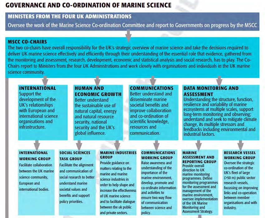
UK National Capability

•       Focus across groups on the same National Capability tools*
    •      NEMO ocean model
    •      NEMOVAR ocean data assimilation
    •      ERSEM / Medusa ocean biogeochemistry
•       Partnership creates a framework where this coming together has
        happened
•       Partnership plays a significant role in ensuring horizon scanning for
        next generation capability, understanding needs across forecasting,
        climate and research, to find the sweet spot.

                                               * Where appropriate. Diversity can play a role too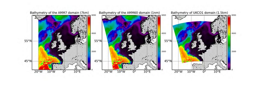
Summary of Activities
Activity Groups:
• Coastal Processes
• Marine Data Assimilation
• Marine Prediction on Seasonal to Centennial Timescales
• Marine Biogeochemistry Modelling
• Observational Datasets: Gaps and Requirements
• Surface Waves
• Next Generation Modelling
Plus Stakeholder Engagement and Communications Activities:
Marine Governance in the UK - II
Observational Datasets: Gaps and
                           Requirements

• Building links between in-situ and
  remote sensing observational and
  modelling communities
• Link to UK-IMON, GOOS,
  OceanObs19
• Models and modelling needs inform
  observational network design
   AG Leads
   (in situ / IMON)   matthew.palmer@noc.ac.uk
   (EO)               chris.banks@noc.ac.uk
Met Office

                       The Met Office is the UK’s national
                               weather service

www.metoffice.gov.uk                                    © Crown Copyright 2018, Met Office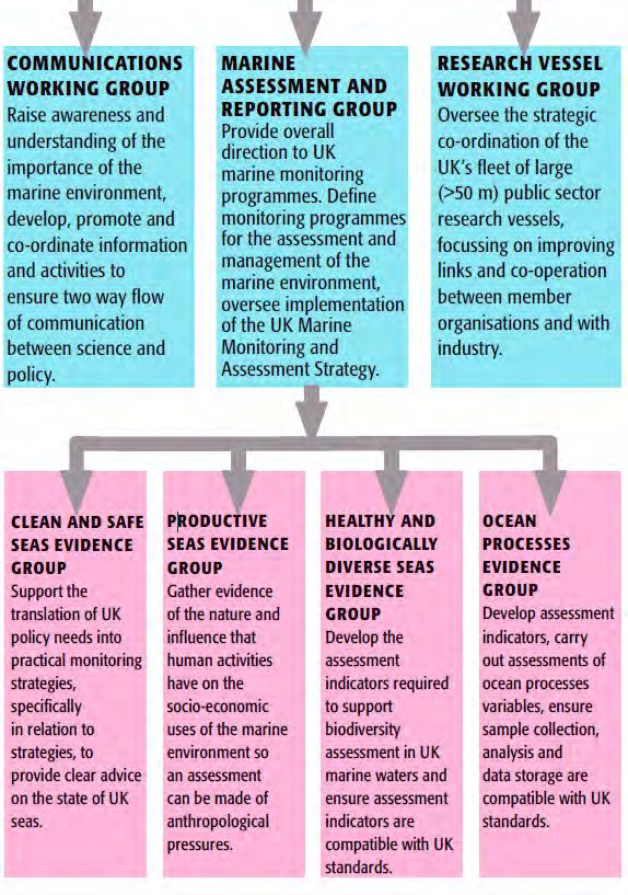
Forecast Models and Systems

• SST & sea-ice satellite and in situ obs. analysis
  (OSTIA)
   - foundation SST and diurnal temperature
• Surface waves based on NCEP’s WAVEWATCH III®
   - Runs 4 x daily, including an ensemble
• Storm surge based on POLCOMS (moving to NEMO)
   - Runs 4 x daily, including an ensemble
• Ocean (FOAM) using NEMO-CICE with NEMOVAR
  data assimilation
   - 3D monitoring and prediction, including
      biogeochemistry
• Coupled Atmosphere-Ocean-Wave-Ice-Land research
  systems
Joint Marine Modelling Programme (JMMP)

Coordinates configurations of the global ocean, sea ice and north-west shelf
using the NEMO model.

responsible for providing national capability modelling infrastructure and
configurations to support the UK's scientific research and operational prediction
systems for ocean, weather and climate.

includes operational oceanography, coupled NWP, monthly to decadal
forecasting and climate projections.

JMMP is led by a management group represent the Met Office, National
Oceanography Centre (NOC) and British Antarctic Survey (BAS) and is
overseen by a governance group who can allocate resources to JMMP.

Helene Hewitt, Head of JMMP, Met Office,helene.hewitt@metoffice.gov.uk
National Oceanography Centre

“The National Oceanography Centre is the UK’s centre of excellence for
oceanographic sciences. We have a remit to provide national capability
and leadership for big ocean science.”
NOC Science Program Model Data
 Sets

UK Earth System Modelling (Joint with Met Office)
Develop Ocean and BGC models
• Not limited to operational products
• Many global and regional model data sets among
  the partners available for community use          https://surgedemo.z16.web.core.wi
                                                                 ndows.net
e.g.
NEMO-MEDUSA 1/12 deg
Next run: climate forced -> 2100
Marine Prediction on Seasonal to Centennial
Timescales
Future Change in Circulation:
• Provides a focal point for
scientific discussion on shelf
seas and coastal forecasts and
projections from months to 100
years ahead
• Links to UKCP and MCCIP
• How to does marine community
benefit from improved seasonal
forecast skill?
Led by Richard Wood: richard.wood@metoffice.gov.uk Holt et al 2018 GRLMarine Scotland “Marine Scotland is a civil service directorate within the Scottish Government, responsible for leading the protection of Scotland’s coastal waters and seas, to both build sustainable economic growth from Scotland’s marine assets, and to safeguard its valuable marine ecosystems.”
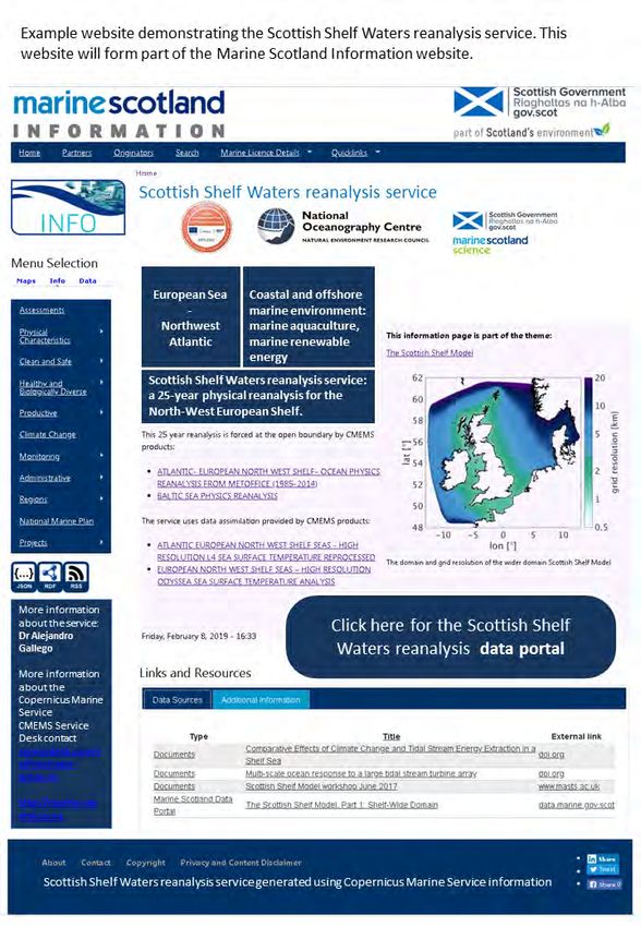
Scottish Shelf Waters Model
• NOC and Marine Science Scotland
• Unstructured mesh, physics
• Currently 1-year climatology
• New reanalysis under production:
  1992-2016
• By November 2020
• Integrated with CMEMS products

Michela de Dominicis, NOC
Alejandro Gallego, MSS
MSS Emergency Response – oil spills mainly
•    GNOME 2D oil trajectory modelling
•    Relies on UK operational model output
     AMM7/AMM15
      – 6 day forecast
      – Hindcast data available
      – Ca. 7/1.5 km resolution
•    Using Scottish Shelf Model currents:
      – Finer resolution, i.e. ~150 m
      – Represent our complex inshore
        circulation much better
      – Not yet operational so only used for
        contingency/spatial planning
Centre for Environment, Fisheries and
Aquaculture Science
Is an executive agency of the United Kingdom government Department for
Environment, Food and Rural Affairs.
Cefas is a world leader in marine science and technology, providing
innovative solutions for the aquatic environment, biodiversity and food
security.Water Quality Modelling - From regional to coastal applications
Regional models are too coarse to investigate water quality Poole Harbour
issues at finer scales (estuaries, harbours, etc.) Need for higher resolution models,
preferably unstructured grids, that
resolve both hydrodynamics and the
complexity of the biogeochemical
processes
TelemacOcean Prediction Coastal Processes Activity Group
• How to fill the gap of high resolution
FVCOM
hydrodynamic and biogeochemical/water
quality models in coastal areas at a UK
wide scale?
• To create synergies between the diverse
approaches at these fine scales
• To link land and ocean
Telemac
• To understand estuarine -> coastal scale
processes
AG Lead: luz.garcia@cefas.co.ukPlymouth Marine Laboratory Research activity at PML broadly investigates global-scale issues of climate change and sustainability, centred around biogeochemistry and systems science, ecosystem health and human health, and sustainable development and biodiversity. NCEO provides the UK’s Natural Environment Research Council with national capability in Earth observation science – monitoring the health of our planet through satellite instruments and more. National Centre for Earth Observation
Assimilation of Plankton
                                     Functional Type

Assimilating Plankton Functional Type chlorophyll significantly reduces
errors in the community composition, and the improvement is still
significant after 5 days forecast
Marine Data Assimilation Activity Group
Oxygen deficiency in reanalysis
• Innovative, stakeholder-oriented simulation
data assimilation approaches
• Reanalyses and forecasts
• Hydrodynamics and BGC
• Engage with multiple communities
• Regular workshops
AG Lead Stefano Ciavatta
avab@pml.ac.uk
Ciavatta et al 2016 JGRChallenges and future directions www.metoffice.gov.uk © Crown Copyright 2019, Met Office
Future directions / challenges
                                                                              Research   R2O*

• Environmental Prediction systems (Earth Systems for the short-range)           ✔        ✔
• Ensemble / probabilistic ocean forecasts                                       ✔        ✔
• Advanced verification (esp. Hi-Res systems)                                    ✔        ✔
• Next Gen systems (computational layers / new science)                          ✔        ✔
• Scalable complexity biogeochemistry models                                     ✔        ✔
• Couple to statistical models to go beyond model variables                      ✔        ✔
• Post-processing ocean parameters                                               ✔        ✔
• Machine Learning and Artificial Intelligence                                   ✔        ✔
To do these things we need:
• Adapted, use-orientated, fit-for-purpose ocean observing networks              ✔        ✔
                                                  *Route to operations clear for forecast products
Ensemble coupled prediction
Regional coupled prediction system
                    AMM7 ocean

                       Modelling systems

                 AMM15 ocean,
                 AMM15 wave,
                 UKV atmosphere

                                  Lewis et al., 2018 (GMD)
Results
Wave coupling and atm
coupling improve
results,
Cliquezparticularly
et modifiez le
near-coast
titre
Fully coupled atm-ocn-wav
Coupled atm-ocn
Wave-forced ocean run
Ocean only control
Mean MODEL – OBS SST difference
against in-situ observations, July 2014:Evaluating Coupled NWP on Weather
vs Obs vs Anal
N640 winter trial
vs Obs
NWP Index:
Basket of measures, largely
positive
Net positives for all trials
(~0.5 – 0.9 NWP increase)
TC track also improved (not
vs Anal
shown)Thank you www.metoffice.gov.uk © Crown Copyright 2018, Met Office
EuroGOOS and NOOS

The European Context is, and has always, been important to us

EuroGOOS coordinates European Operational Oceanography

NOOS is regional alliance that does practical implementation around UK and
neighbours waters:
          • Critical mass of like-minded experts for advocacy and visibility
          • Sharing of observations
          • Sharing of expertise
CMCC (Italy)
Met Office (UK) Puertos de Estados (Spain)
BSH (Germany)
NERSC (Norway) CNR (Italy)
SHOM (France) MeteoFr (France) Ifremer (France)
CNRS (France) IRD (France)
mercator-ocean.eu/marine.copernicus.euGODAE OceanView / OceanPredict
GOV provides
international
science
leadership for
operational ocean
forecasting
The Met Office Ocean Forecasting group provides a number of experts to this
international consortium
• we lead two of the six international task teams
• we are on both the Science Team and the Patrons Group
• the GOV project office is led from the Ocean Forecasting teamEuropean Commission
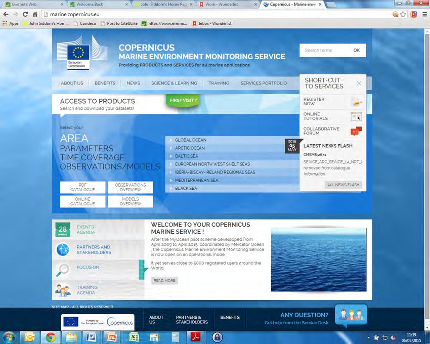
Copernicus Marine Environmental Monitoring Service
E
Glob NAC
Successfully al in
situ
T
obs
operating:
• North-West Shelf 7
FOAM/GloSEA A MM elf
M h
FOA
Global coupled
rth-
W est S
forecasting
ting OSTIA
• Global SST/Ice No cas
fore Global SST/Ice analysis
• Global In Situ
• Coupled globalNew HPC LFRic
2014 2015 2016 2017 2018 2019 2020 2021 2022 2023 2024
Coupled DA system developed Coupled DA forecasts to CMEMS Weakly coupled analyses, N320 atmos,
¼ deg ocean
Weakly coupled analyses, N1280 atmos,
¼ deg ocean (ensemble N640 atmos) Coupled NWP system developed Coupled NWP forecasts
Upgrade to ORCA12
N768 Global Model N1280 Global Model Introduce full ocean ensemble
Couple global wave configuration?
¼ deg FOAM ocean 1/12 deg FOAM ocean FOAM retired?
• Coupled NWP project is trialling NWP operational systems with PS41 N1280 and lower resolution versions
• Aim for implementation at PS46 (go live early 2021) to replace NWP deterministic and MOGREPS-G
• A coupled system will result in retiring ocean, and potentially, wave only forecast systems, and facilitate coupled ensembles
www.metoffice.gov.uk © Crown Copyright 2018, Met OfficeChallenges: lack of in situ data
Match-ups to in situ data for 1998-2010:
temperature 745641
salinity 738288
chlorophyll 56740
pH 11322
Very limited Bio-ARGO data
Kay – Ocean Predict 2019 – HalifaxSurface Waves
• Improving the up take of Future wave projections:
wave information by
developing a network
across a diverse range
of stakeholder.
Palmer…Bricheno… et al 2018
john.bacon@cefas.co.ukCopernicus Products: Ocean Physics, Waves and
Biogeochemistry 6-day forecast
• AMM15 1.5km resolution
• AMM7 7km for BGC
• Assimilates SST,
profiles, sea level
• Hourly and daily mean
data, 33 levels
• From 01-01-2017
• Run at Met Office
http://marine.copernicus.eu/services-portfolio/access-to-products/Copernicus Products: Ocean Physics and Biogeochemistry
Reanalysis
Extensive quality assessment
• AMM7 7km resolution and validation
• Assimilates SST,
Profiles, Sea level
• Hourly and daily mean
data, 33 levels
• From 01-01-1992
physics
• From 01-01-1998 BGC
• Run at Met Office
http://resources.marine.copernicus.eu/documents/QUID/CMEMS-
NWS-QUID-004-009.pdf
http://marine.copernicus.eu/services-portfolio/access-to-products/Assimilation Ensembles SMOS SWOT Gliders
Observations Assimilated on Shelf Region

                 Temperature
                 profiles

                   Salinity
                   profiles

                                                                      Example coverage of satellite altimeter observations
                                  Example daily coverage of SST obs   for 1-month from Sentinal-3, Jason-3, Cryosat and
Example monthly coverage of T/S                                       AltiKa (top) and those assimilated (bottom).
Data assimilation in High Resolution
models
•Assimilation of satellite and in situ SST Global North-West Shelf
data, satellite altimeter SLA data (in the
deep part of the domain), and in situ 1/4°
AMM7
temperature/salinity profiles has been
implemented in AMM15 and ORCA12.
• First implementation of DA in AMM15 gives
similar accuracy to AMM7, while
maintaining the high resolution model SST (°C)
information.
•Further tuning needed for high resolution 1/12°
satellite and e.g. glider observations. AMM15
•Computational efficiency of the data
assimilation in the high resolution is an isse.
www.metoffice.gov.uk © Crown Copyright 2018, Met OfficeAssimilation and Biogeochemistry Status • Surface chlorophyll-a implemented in reanalysis • Soon to be implemented in forecasts • Results really promising Next steps • Plankton Functional Type from EO • Gliders and other profiles Challenges: • The effect of physics DA on BGC • Poor obs quality, quantity and timeliness • Balancing increments
Global Ensemble Development
                                             •   Flux perturbed from NWP Ensemble
                                             •   Obs value perturbed
                                             •   Obs location
                                                           • perturbed
                                                               Also seen are weather effects which would not be
   •   Spin-up clearly visible                               • present if we are
                                                                  Also seen  just weather
                                                                                  perturbed  the forcing.
                                                                                          effects  which would not be
   •   As are day to day variations in the spread (errors of     present if we just perturbed the forcing.
SST    the day).                                                SSS

                                                                                      PSU
                    ⁰C
Developing the shelf seas ensemble
Ensemble standard deviation over first month
Currently only perturbing
observations, so dominated by
perturbations from SST and
off-shelf profiles/altimeter.
Other aspects required to
introduce spread below ML.
Need work to understand if
spread from these perturbations
is realistic/sufficient.
SST SSS
0 - 0.2K 0 - 0.05 PSUHow important is the extra resolution?
AMM7 20 mins per day AMM15 110 mins per day
Sample output: surface log-chlorophyll
for 2016-06-15Cefas Emergency Response Modelling
Oil and Chemical Spills
OSCAR
Responders, Regulators, Governments
UKMO winds Sintef
And wider markets
Chemmap
& Parameterisation
CMEMS
& Interpretation
Model selection
ASA
currents
Analysis
(AMM7 -
>AMM15) DREAM
Sintef
Tidal
Database/High
Resolution
Models
Cefas Spill
(Telemac)C-RISC
Coastal Resilience to flooding Impact through relocatable Storm
surge forecasting Capability for developing nations
Dr Jeff Polton (National Oceanography Centre)
Dr Simon Holgate (Sea Level Research Ltd)
Jason Holt, Christine Sams, Tom Prime, Anthony Wise, Kevin Horsburgh (NOC)
Madagascar is exposed to cyclone risks, (~3-4 cyclones / year)
6000 km coastline & 1,250 fishing villages: marine activities important
to Madagascar’s social and economic life
Coastal communities at risk from climate variability and change
Spécification idéale:
contrôlé localement
personnalisé localement
résilience opérationnellehttps://surgedemo.z16.web.core.windows.net
Prototype Summary
Meteorology: NCEP/NOAA (Global Forecast System) winds + sea level pressure (hourly, 1/4 deg)
Tides: FES2014
Ocean: NEMOv4
Output: 5 day forecast - hourly SSH (data / images)
Hosted on Azure cloud service (Micosoft)
Automated:
• meteorology download
• model run
• diagnostic processingMarine Biogeochemistry Modelling
• To facilitate the pull-through
of cutting-edge BGC model
developments into
operational systems and key
applications
• To facilitate the uptake of
stakeholder needs into
model and product
Making modelling count -….
developments in order to
promote the use of BGC Hyder et al 2015
product by stakeholders
Yuri Artioli
yuti@pml.ac.ukThe Scottish Shelf Model and CMEMS
• FVCOM implementation
• One wider domain model and 8 (and growing)
higher-resolution nested sub-domains
• FOAM AMM7 boundary forcing (moving to
AMM15)
• Grid 2 Grid model climatology for freshwater
• ECMWF ERA-Interim data for atmospheric
forcing Bathymetry
• Not (yet) operational but working on it
– Finer resolution met forcing (UKV?) Wide domain and sub-domains
– Only for the higher resolution sub-models?
Present-day and 2050’s climatologiesGoing beyond biogeochemistry Coupling to Higher Trophic Level models to provide information for fishery, aquaculture, diversity, ecological status… Aquaculture mussels production (left) and the impact on particle fluxes (mid) and benthic fauna (right)
Resolutions

www.metoffice.gov.uk

                       © Crown Copyright 2019,
What resolution is good enough
• Eddy-resolving at the global scale?
• With tides at 1/25o ?
Eddy-resolving at the shelf scale?
With unstructured grids for coastlines? At ~1 km?
Bridging the land and the ocean?
Estuarine scale interactions upscaling / downscaling from-to the shelf-wide
solution?
www.metoffice.gov.uk © Crown Copyright 2019, Met OfficeFOAM-ORCA12
• The Met Office’s Forecasting Ocean Assimilation Model (FOAM) global system replacement will be
at 1/12o nominal resolution
• Co-developed with National Oceanography Centre, and aligned with DRAKKAR (FR) developments
(Mercator etc.)
• Represents dominant scales, notably at high latitudes
• In process of final developments for operations (R2O)
__ Rossby radius 5 year SSH standard deviation from free model runs
__ ORCA12
--- ORCA025
ORCA025 ORCA12FOAM-AMM15
• 1.5 km Eddy-resolving on shelf
• Same domain as UK Atm Model
Surface current [m/s] 02-10-2018 +12h
• Generally difficult using standard metrics to
demonstrate improvement
• HiRes process studies show improvements
• Improved salinity in the full water column
• More realistic surface currents
AMM7
Tonani et al., 2019 OSD With thanks to Marina TonaniChallenges
• Exascale, low-memory, high-processor environments
Assimilation techniques and
• Coupled weather / hazard prediction
supporting observations
• Machine learning and data-based solutions
• Post-processing
• Customer/user demands for more …
• resolution
• probabilistic information
• earth system information
• global reach
• hazards and impacts information
• tailored products
• cost savingsYou can also read