VARDA (VARved sediments DAtabase) - providing and connecting proxy data from annually laminated lake sediments
←
→
Page content transcription
If your browser does not render page correctly, please read the page content below
Earth Syst. Sci. Data, 12, 2311–2332, 2020
https://doi.org/10.5194/essd-12-2311-2020
© Author(s) 2020. This work is distributed under
the Creative Commons Attribution 4.0 License.

              VARDA (VARved sediments DAtabase) – providing
                 and connecting proxy data from annually
                        laminated lake sediments
        Arne Ramisch, Alexander Brauser, Mario Dorn, Cecile Blanchet, Brian Brademann, Matthias Köppl,
         Jens Mingram, Ina Neugebauer, Norbert Nowaczyk, Florian Ott, Sylvia Pinkerneil, Birgit Plessen,
                             Markus J. Schwab, Rik Tjallingii, and Achim Brauer
             GFZ German Research Center for Geoscience, Section Climate Dynamics and Landscape Evolution,
                                      Telegrafenberg, 14473 Potsdam, Germany
                              Correspondence: Arne Ramisch (arne.ramisch@gfz-potsdam.de)

                                    Received: 5 March 2020 – Discussion started: 30 March 2020
                          Revised: 27 July 2020 – Accepted: 3 August 2020 – Published: 25 September 2020

       Abstract. Varved lake sediments provide climatic records with seasonal to annual resolution and low associated
       age uncertainty. Robust and detailed comparison of well-dated and annually laminated sediment records is crucial
       for reconstructing abrupt and regionally time-transgressive changes as well as validation of spatial and temporal
       trajectories of past climatic changes. The VARved sediments DAtabase (VARDA) presented here is the first
       data compilation for varve chronologies and associated palaeoclimatic proxy records. The current version 1.0
       allows detailed comparison of published varve records from 95 lakes. VARDA is freely accessible and was
       created to assess outputs from climate models with high-resolution terrestrial palaeoclimatic proxies. VARDA
       additionally provides a technical environment that enables us to explore the database of varved lake sediments
       using a connected data model and can generate a state-of-the-art graphic representation of a multisite comparison.
       This allows the reassessment of existing chronologies and tephra events to synchronize and compare even distant
       varved lake records. Furthermore, the present version of VARDA permits the exploration of varve thickness data.
       In this paper, we report in detail on the data-mining and compilation strategies for the identification of varved
       lakes and assimilation of high-resolution chronologies, as well as the technical infrastructure of the database.
       Additional palaeoclimatic proxy data will be provided in forthcoming updates. The VARDA graph database
       and user interface can be accessed online at https://varve.gfz-potsdam.de (last access: 15 September 2020), all
       datasets of version 1.0 are available at https://doi.org/10.5880/GFZ.4.3.2019.003 (Ramisch et al., 2019).

1   Introduction                                                   transgressive climate change on the continents (e.g. Lane
                                                                   et al., 2013; Rach et al., 2014), which are fundamental to un-
A major challenge in simulating climate change is validating       derstanding past climates, especially that of the last glacial
model outputs with palaeoclimatic data. Model–data com-            cycle (Clement and Peterson, 2008), and to better assess
parisons on regional to global scales require the integration of   spatial and temporal trajectories of future climate changes.
palaeoclimatic data from single sites into multisite networks      Networks of varved lake sediments also provide means to
(e.g. Franke et al., 2017). Annually laminated lake sediments      test contrasted proxy responses to climate change (e.g. Ott
provide reliable data for such networks because they of-           et al., 2017; Ramisch et al., 2018; Roberts et al., 2016), fur-
fer palaeoclimatic information in high temporal resolution         ther enhancing the robustness of palaeoclimatic reconstruc-
with low associated age uncertainty. Due to their annual to        tions. However, despite their usefulness for the generation
seasonal resolution, multisite networks of varved lake sed-        of highly resolved multisite networks, a global synthesis of
iments enable investigations of abrupt and regionally time-        varve-related palaeoclimatic data is still not available.

Published by Copernicus Publications.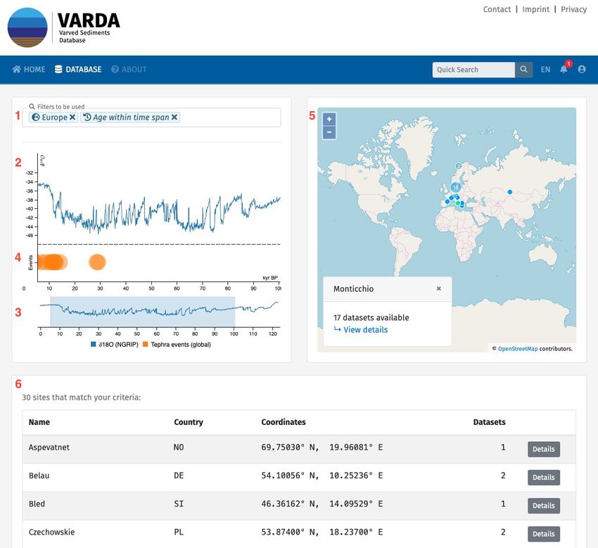
2312                                                              A. Ramisch et al.: VARDA (VARved sediments DAtabase)

   Various data providers have been developed which of-           lication, the digital object identifier (DOI) of the publication
fer free access to palaeoclimatic and palaeoenvironmen-           or the data provider (if available) was additionally collected
tal information including high-resolution terrestrial archives.   and stored.
These include (1) large-scale data repositories, such as
PANGAEA (http://www.pangaea.de, last access: 15 Septem-           2.2     Data compilation
ber 2020), the National Oceanic and Atmospheric Adminis-
tration’s (NOAA) World data service for palaeoclimatology         To ensure an unambiguous identification of a lake record cor-
archives (http://www.ncdc.noaa.gov, last access: 15 Septem-       responding to a given dataset, we collected and reviewed the
ber 2020) and Neotoma (http://www.neotomadb.org, last             required information of lake names and geographic coordi-
access: 15 September 2020, Williams et al., 2018), and            nates from the published literature. Table 1 lists required and
(2) proxy- or time-slice-specific databases like the ACER         additional information for lake records included in VARved
(Sánchez Goñi et al., 2017), the European Pollen database         sediments DAtabase (VARDA). To facilitate searches for
(Fyfe et al., 2009), the SISAL database (Atsawawaranunt           lakes in an alphabetically ordered list, the string “Lake”
et al., 2018), or the PAGES2k Global 2000 Year Multi-             was removed from the name if the string appeared in the
proxy Database (Pages 2k consortium, 2017). However, the          beginning of the lake name (e.g. “Lake Ammersee” was
distribution of information between data providers makes a        changed to “Ammersee”). However, exceptions were made if
custom generation of multisite networks from varved sedi-         the string “Lake” is an essential feature of the lake name (e.g.
ments inefficient and time-consuming. Moreover, continuous        “Lake of the Clouds”) or if the reference is in non-English
geochronological development results in frequent updates of       language (e.g. “Lac d’Annecy”). Lake locations were stored
fundamental methods such as calibration curves (e.g. Reimer       as WGS84-referenced geographical coordinates in decimal
et al., 2004, 2009, 2013) and age–depth modelling algorithms      degrees with four decimal places, which corresponds to a
(e.g. Bronk Ramsey, 2008; Blaauw and Christen, 2011). In-         precision of ∼ 10 m. This even allows a reliable location of
corporating such changes into existing varve-related datasets     small lakes with a surface area < 1 ha and is especially use-
requires an interactive approach that is not offered by fixed     ful for dense lake distributions common in large lake dis-
data structures of standard relational database management        tricts such as those in Canada or Scandinavia. Since the re-
systems. To overcome these limitations, we developed a new        quired precision was not available in most publications, we
and state-of-the-art graph database especially (but not exclu-    reassessed the published geographical location using ArcGIS
sively) for varved sediment records. The database was devel-      and Google Earth. All lake locations refer to the approximate
oped within the German climate modelling initiative PalMod        lake centre and are independent from coring locations.
(Latif et al., 2016), to validate the output of comprehensive        Sediment composite profiles that were collected from pri-
Earth system models with reliable proxy data from terres-         mary literature sources (see Table 2) only require a unique
trial and marine (Jonkers et al., 2020) archives. We com-         identifier (e.g. MON for Lago Grande di Monticchio) within
piled all available and published varved sediment records and     the VARDA database that links a profile to a correspond-
developed criteria for how these data are integrated in this      ing lake (Table 2). Additional information encompasses the
database.                                                         geographical coordinates of coring location (fields: latitude,
                                                                  longitude), coring methods (e.g. piston corer), a coring date,
                                                                  water depths at the core location, and the total length of the
2     Data and methods
                                                                  sediment composite profile with an upper (field: depth start)
2.1    Data mining
                                                                  and lower (field: depth end) depth.

We assessed varve-related publications aided by the lit-          2.2.1    Lake and sediment composite profile
erature database of the PAGES varve working group                          meta-information
(http://www.pastglobalchanges.org/download/docs/
working_groups/vwg/Varvepublications.pdf, last access:            The data compilation followed the basic strategy of collect-
15 September 2020) to identify lake archives exhibiting           ing proxy data associated with a published sediment com-
varved sediments and to compile suitable core-related             posite profile and information about age–depth models and
palaeoclimatic proxy time series. A comprehensive set of          event layers. A sediment composite profile may either consist
lake sediment records was identified, for which proxy data        of a single core section or several overlapping core sections
from continuous or floating varve sequences were previously       combined to a composite profile. The depth scale within a
published. All data were collected as raw data from freely        sediment composite profile is referred to as composite depth.
available online sources, either from online data repositories    Since data and meta-information availability greatly varied
(PANGAEA, NOAA, and Neotoma) or data archives within              in between different publications, we classified the available
the supplementary materials section of online publications.       information into required and additional information. The
For a permanent and definite assignment of the compiled           category required encompasses all information that is nec-
datasets within the database to their respective original pub-    essary to (a) associate a proxy value at a given depth in a

Earth Syst. Sci. Data, 12, 2311–2332, 2020                                        https://doi.org/10.5194/essd-12-2311-2020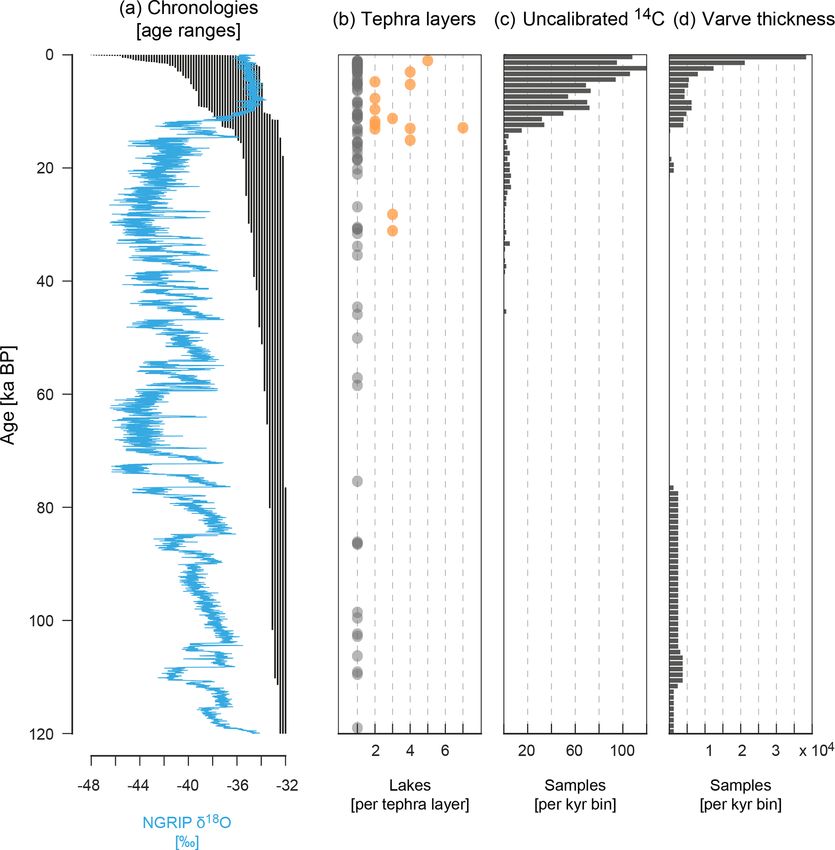
A. Ramisch et al.: VARDA (VARved sediments DAtabase)                                                                                  2313

Table 1. VARDA v01 data sheet for lake information (green field: required information; yellow field: additional information).

  Attribute:        Name     Latitude Longitude                   Elevation         Max depth         Surface area       Catchment area
  Default units:    String   Decimal degrees (four-digit scale)   m a.s.l.          m                 m2                 m2

Table 2. VARDA v01 data sheet for sediment composite profile information (green field: required information; yellow field: additional
information).

        Attribute:       Label    Latitude Longitude      Coring method       Drill date    Water depth    Depth start    Depth end
        Default units:   String   Decimal degrees         String              dd/mm/year    m              mm             mm
                                  (four-digit scale)

sediment composite profile with a corresponding age and to              2.2.3    Age–depth models and chronologies
(b) uniquely identify a lake, sediment composite profile, and
original publication for a given dataset. The category addi-
                                                                        Chronologies for varved lake sediments are commonly based
tional encompasses all information that extends the data pool
                                                                        on a combination of different dating methods (Brauer et al.,
for more comprehensive analyses and therefore improves re-
                                                                        2014), such as varve counting, radiometric dating (e.g. 14 C,
producibility, the ability to filter data by specific properties        137 Cs, or 210 Pb) and event age-equivalent dating (e.g. corre-
and, in addition, the quantification of methodological uncer-
                                                                        lation to dated volcanic eruptions). Age–depth models pro-
tainties. We converted all datasets to default units to pro-
                                                                        vide the time frame for down-core sequences of sediment
vide standardized and thus inter-comparable data formats.
                                                                        composite profiles and allow transformations of sediment
Tables 1–7 provide an overview of data categories and re-
                                                                        proxy records into time series. Initially, most researchers
quired and additional information properties including the
                                                                        constructed age–depth models by simple linear interpola-
default units.
                                                                        tion between individual chronological points. However, age–
                                                                        depth modelling algorithms such as the OxCal P-Sequence
2.2.2    Radiocarbon dates                                              (Bronk-Ramsey, 2007) or Bacon (Blaauw and Christen,
Uncalibrated radiocarbon measurements were collected from               2011) have become more common and perform more com-
the published literature and adapted to the 14 C data report-           plex statistical interpolations.
ing standards of Millard (2014). This allows efficient re-                 VARDA version 1.0 includes published chronologies that
assessments of published chronologies by calibration, age–              are available in public data repositories. Tables 4 and 5
depth modelling, and age uncertainty estimation (see Ta-                provide an overview of the required and additional meta-
ble 3). However, reporting standards are not yet fully adapted          information for storing chronologies in VARDA and the re-
in the palaeoclimatic community, leading to variations in re-           sulting chronological data sheet, respectively. The required
ported information and data gaps. The required information              information includes a label for the associated sediment com-
encompasses from left to right (i) the sampling depth (field:           posite profile and the corresponding data and publication
composite depth); (ii) the uncalibrated age (field: age uncal-          DOI. Additional information will enable rapid reassessments
ibrated); (iii) the associated measurement error (field: error);        of original chronologies.
(iv) the error type (e.g. 1 sigma); and (v) the dated material             Additional information reports (i) on age uncertainty;
(e.g. wood remains). The required sampling position refers              (ii) presence, type, and age of anchor points for floating
to the depth within the sediment composite profile, whereas             chronologies (e.g. sediment surface for continuous varve
the sampling position within the individual core sections can           chronologies, 14 C dates, or elsewhere-dated tephra layers for
be attributed as additional information. If available, we col-          floating chronologies); (iii) the applied dating methods (e.g.
lected additional information on (i) the corresponding core             varve counting, radiometric dating, or event layers); (iv) the
section label (field core section); (ii) section depth (field: sec-     interpolation method (e.g. linear interpolation or Bayesian
tion depth); (iii) the lab code; (iv) δ 13 C data; (v) the measure-     age–depth modelling, such as OxCal P-sequence or Bacon);
ment method (field: method), e.g. AMS 14 C; (vi) the organic            (v) the applied 14 C calibration curve (e.g. IntCal09); and (vi)
carbon content of a sample (field: % C); and (vii) C / N ra-            the resulting median resolution of the chronology.
tios.                                                                      Ideally, the chronological data sheet associates a given
                                                                        depth of a sediment composite profile to an age estimate and,
                                                                        if available, an uncertainty range expressed as minimum and

https://doi.org/10.5194/essd-12-2311-2020                                               Earth Syst. Sci. Data, 12, 2311–2332, 2020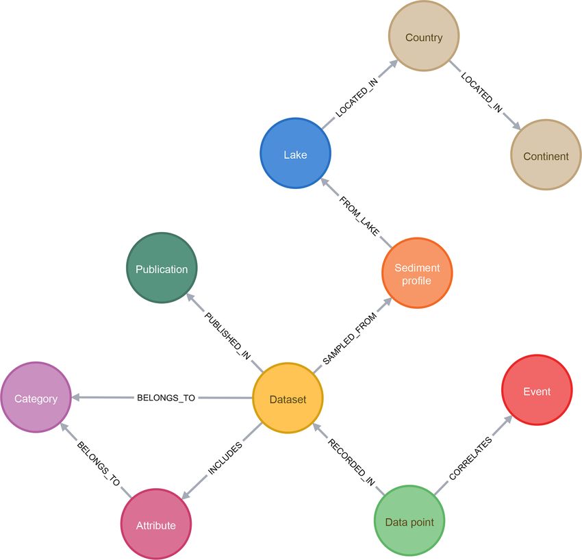
2314                                                                     A. Ramisch et al.: VARDA (VARved sediments DAtabase)

Table 3. VARDA v01 data sheet for 14 C information (green field: required information; yellow field: additional information).

   Attribute:        Sediment com-     Lab code          Section depth    Composite depth       Age uncalibrated     Error
                     posite profile
   Default units:    String            String            mm               mm                    a BP                 ±a

   Attribute:        Error type        Dated material      δ 13 C         Method                %C                   C / N ratio
   Default units:    1 sigma [%]       String              ‰              String                %                    dimensionless

Table 4. VARDA v01 data sheet for chronological meta-information (green field: required information; yellow field: additional information).

  Attribute:        Sediment com-     Data DOI           Publication        Has uncertainty?      Uncertainty type        Anchored?
                    posite profile                       DOI
  Default units:    String            String             String             Boolean               String                  Boolean

  Attribute:        Anchor point      Anchor point       Dating method      Interpolation         14 C calibration        Median
                    type              age                                   method                curve                   resolution
  Default units:    String            a BP               String             String                String                  a

maximum estimate as additional information (2 sigma as a                 iment composite profile and storing information on the age
default). If depth information for a sediment composite pro-             of the layer as it has been reported. Since standards for age
file was not provided, we either reconstructed an auxiliary              reporting of tephra layers greatly vary in between different
composite depth by cumulative sums of continuous varve                   studies (e.g. uncalibrated vs. calibrated), information on the
thickness measurements (if available) or excluded the corre-             dating method and calibration are required for the field “dat-
sponding chronology from the present data compilation be-                ing method or calibration”. The required field “dated in pro-
cause such time series without corresponding core depth are              file?” provides information on whether the age of the tephra
not updatable. The default depth scale unit was set to mil-              layer originates from the corresponding sediment composite
limetres to avoid excessive decimal places in depth report-              profile itself (field = true) or if the age was adapted from the
ing. The default age scale unit was set to a BP (year before             literature (field = false). If the age was adapted from the liter-
present) with 1950 CE as zero age. The default age unit was              ature, a DOI from the original publication is required. Further
restricted to annual precision and ages are reported in integer          event layers such as geomagnetic excursions will be included
numbers (without usage of decimal places).                               in forthcoming versions of VARDA.

2.2.4   Isochronous event layers                                         2.2.5   Proxy data

Isochronous event layers provide precise tie points for the              The technical infrastructure of VARDA is intended to
synchronization of proxy time series from regionally differ-             attribute a down-profile record of palaeoclimatic proxy
ent locations and facilitate the construction of multisite net-          data to the corresponding chronology of the sediment
works. Furthermore, the identification of layers correspond-             composite profile. Therefore, the required information
ing to dated events such as volcanic eruptions or geomagnetic            for proxy data sequences is the composite depth and a
excursions provide additional information for the construc-              corresponding proxy measurement, while additional in-
tion of robust chronologies. For the first version of VARDA,             formation further describes proxy specific measurement
we collected information on reported tephra layers in the sed-           standards. We adapted the variable controlled vocabu-
iment composite profiles included in the database. Table 6               lary of the PaST thesaurus for proxy data (World Data
provides an overview of required and additional information              Service for Paleoclimatology, https://www.ncdc.noaa.gov/
of published tephra layers in VARDA. The required informa-               data-access/paleoclimatology-data/past-thesaurus, last ac-
tion (composite depth, age, age error, and dating method) is             cess: 15 September 2020). Therefore, all proxy records will
essential for assigning a tephra layer to a given depth in a sed-        be broadly categorized into biological, sedimentological,

Earth Syst. Sci. Data, 12, 2311–2332, 2020                                                  https://doi.org/10.5194/essd-12-2311-2020
A. Ramisch et al.: VARDA (VARved sediments DAtabase) 2315
Table 5. VARDA v01 chronology data sheet (green field: required information; yellow field: additional information).
Attribute: Sediment composite depth Age Age min Age max
profile
Default units: String mm a BP a BP a BP
Table 6. VARDA v01 data sheet for tephra layers (green field: required information; yellow field: additional information).
Attribute: Lab code Composite depth Age Error Dating method or calibration
Default units: String mm a BP ±a String
Attribute: Correlated to Source locality Major element Trace element Dated in Age transfer
event data available data available profile? reference
Default units: String String Boolean Boolean Boolean DOI
and geochemical proxy data. In the present version of the of queries that are short and readable even for complex pat-
database, we included varve thickness data that were found terns (many relationships, circular structures, variable-length
in public data repositories. Table 7 lists the required and addi- paths).
tional information concerning varve thickness records. Fur- The integration of palaeoenvironmental datasets from
ther proxy data such as stable-isotope, pollen, or X-ray flu- varved lakes into a graph database resulted in a flexible data
orescence (XRF) core scanning records will be included in structure, which allows for connected palaeoenvironmental
forthcoming versions of VARDA. datasets within a single lake as well as in between different
lakes. Figure 1 illustrates the VARDA property graph model
3 Database schematically and visualizes connections between nodes.
The VARDA data model associates each lake with one or
3.1 Database design more sediment composite profiles, which are connected to
one or more datasets. Datasets, in turn, are connected to a
VARDA is intended to offer a flexible generation of mul- publication, a category (chronology, tephra layer, radiocar-
tisite networks with complex data relations for storing and bon date, or varve thickness record in version 1.0) and vari-
organizing the collected information. To store and organize ous category-specific attributes (as listed in Tables 1–7) that
datasets from varved lake archives, we use a graph database. further describe a dataset. All these connections provide the
Graph technology in computer science has evolved as part necessary meta-information to the actual data points, which
of the NoSQL movement (meaning “not only SQL”; SQL: are included in a given data set. Data points from the cate-
Structured Query Language) and is based on graph the- gory tephra layer can additionally connect to an event that is
ory, a mathematical concept of expressing objects as inter- described in more than one lake, e.g. the Laacher See tephra.
connected entities, which dates back to the early works of The event node offers the possibility to connect datasets be-
Leonard Euler in the 18th century (Euler, 1741). In contrast tween different lakes for, e.g. synchronization.
to fixed data schemes required by relational database man-
agement systems (RDBMS), a graph explicitly models rela-
3.2 Application design
tions between data by representing entities as nodes (or ver-
tices) described by properties and connected through edges VARDA provides fast access to palaeoclimatic data from
as shown in Fig. 1 (see also the property graph model). To varved lakes, irrespective of a user’s technical background
categorize the nature of a particular entity, one or more labels or operating system. Therefore, the user interface (UI) was
can be added to the node. Edges can be distinguished by their designed to be intuitive and reactive with self-explanatory
type and may have properties just like nodes. The ability to forms and components that immediately respond to the user’s
add new labels, edges, and properties to any entity at all times actions. It is implemented as an online service, which can be
enables developers to quickly adapt the data model to chang- accessed permanently using a web browser.
ing scientific or technical requirements. Neo4j’s native query Overall, the application consists of the web client, a server-
language Cypher is used to read and update the contents in side Neo4j graph database and an Application Program-
the graph. It allows for an intuitive and flexible generation ming Interface (API) for communication of the client with
https://doi.org/10.5194/essd-12-2311-2020 Earth Syst. Sci. Data, 12, 2311–2332, 20202316 A. Ramisch et al.: VARDA (VARved sediments DAtabase)
Table 7. VARDA v01 data sheet for varve thickness (Green field: required information, yellow field: additional information).
Attribute: Sediment Varve Composite Composite Age Varve thickness
composite number depth depth
profile (varve top) (varve
bottom)
Default unit: String Integer mm mm a BP mm
Figure 1. VARDA property graph model. Coloured circles represent nodes, and grey arrows represent edges between nodes. For an expla-
nation, see the text.
the database. All software libraries that are integrated into tor layers with spatial data. The client state (e.g. user data
VARDA have licenses that are free and permissive. The and entity cache) and any transactions with the database are
client is built with Vue.js, a JavaScript UI framework that handled with Apollo GraphQL, a framework for API com-
has gained attention in the developer community since its munication and state management. The client’s component-
launch in 2014 due to its versatility and runtime performance. oriented architecture enables fast development of new fea-
Some features of VARDA integrate other well-documented tures with little interference with existing modules. All lines
third-party libraries, such as D3.js for data visualization and of source code required by the client are checked, minified,
OpenLayers for rendering maps (e.g. from OSM) among vec- and bundled using WebPack for use in the browser.
Earth Syst. Sci. Data, 12, 2311–2332, 2020 https://doi.org/10.5194/essd-12-2311-2020A. Ramisch et al.: VARDA (VARved sediments DAtabase) 2317
Table 8. Identified lakes, updated geographic coordinates, and datasets included in VARDA 1.0. Letters indicate data availability in data
repositories. Table also includes varved lake sites without publicly available data (without letters and references).
Lake name Latitude Longitude Chrono- Tephra 14 C Varve References
logies layers thick.
A 83,0004 −75,4247
Ahvenainen 60,8263 28,1254
Albano 41,7461 12,6695
Alimmainen Savijärvi 61,7442 24,4016
Ammersee 47,9983 11,1218 A B A: Grafenstein (1999);
B: Czymzik et al. (2013)
Angulinao 41,3500 114,3833
Anterne 45,9910 6,7983 A A: Giguet-Covex et al. (2011)
Arendsee 52,8900 11,4759
Arreo 42,7784 −2,9911
Aspevatnet 69,7503 19,9608 A A: Bakke et al. (2005)
Avigliana 45,0654 7,3870
Ayr Lake 70,4590 −70,0860 A A A: Thomas et al. (2012)
Baldeggersee 47,1979 8,2614
Barrine −17,2504 145,6356 A A: Head et al. (1994)
Bear Lake (Canada) 75,4838 −85,1900
Bear Lake (USA) 41,9950 −111,3382 A A: Colman et al. (2009)
Belau 54,1006 10,2524 A B B A: Garbe-Schönberg et al. (1998);
B: Dörfler et al. (2012)
Berrington Pool 52,6605 −2,7042
Big Round Lake 69,8648 −68,8548 A A A: Thomas and Briner (2008)
Big Watab Lake 45,5526 −94,4524
Bled 46,3616 14,0953 A A: Lane et al. (2011)
Blue Lake 68,0870 −150,4652 A A A A: Bird et al. (2008)
Bosumtwi 6,5014 −1,4113
Bourget 45,7262 5,8673
Bow Lake 51,6644 −116,4486 A A: Leonard and Reasoner (1999)
Bramant 45,1999 6,1759 A A: Guyard et al. (2007)
Brownie Lake 44,9676 −93,3243
Butrint 39,7803 20,0313 A A: Morellón et al. (2016)
C2 82,8276 −77,9860 A A A: Lamoureux and Bradley (1996)
Challa −3,3168 37,7040 A B C A: Verschuren et al. (2009);
B: Blaauw et al. (2011);
C: Wolff et al. (2011)
Cheakamus 50,0080 −122,9179
Constance 47,6017 9,4218
Crawford Lake 43,4684 −79,9488 A A: Yu and Eicher (1998)
Crevice 45,0006 −110,5784 A A: Whitlock et al. (2012)
Czechowskie 53,8740 18,2370 A B; C A: Dietze et al. (2019);
B: Wulf et al. (2016);
C: Wulf et al. (2013)
Dead Sea 31,5352 35,4909 A; B A A: Migowski et al. (2004);
B: Neugebauer et al. (2015)
Deep Lake 47,6830 −95,3993 A B A: Hu et al. (1997);
B: Hu et al. (1999)
Diss Mere 52,3754 1,1075
Donard 66,6625 −61,7875 A B B A: Moore et al. (2001);
B: Moore et al. (2001)
DV09 75,5744 −89,3094 A A A A: Courtney Mustaphi and
Gajewski (2013)
https://doi.org/10.5194/essd-12-2311-2020 Earth Syst. Sci. Data, 12, 2311–2332, 20202318 A. Ramisch et al.: VARDA (VARved sediments DAtabase)
Table 8. Continued.
Lake name Latitude Longitude Chrono- Tephra 14 C Varve References
logies layers thick.
East Lake 74,8882 −109,5342 A A A: Cuven et al. (2011)
Eklutna 61,4053 −149,0259 A A A A A: Fortin et al. (2019)
Elk Lake 47,1891 −95,2179 A B A: Smith et al. (1997);
B: Dean and Megard (1993)
Ellesmere Mere 52,9088 −2,8843
Erlongwan 42,3026 126,3806
Foy Lake 48,1662 −114,3599 A B A: Stone and Fritz (2006);
B: Shuman et al. (2009)
Frängsjön 64,0228 19,7376
Frías −41,0617 −71,7990 A A: Ariztegui et al. (2007)
Frickenhäuser See 50,4029 10,2373
Fukami 35,3256 137,8195
Furskogstjärnet 59,3802 12,0801 A A: Zillén et al. (2002)
Geneva 46,4392 6,5164
Glacier Lake 40,0230 −105,5027
Gosciaz 52,5829 19,3398
Gölcük 31,6270 40,6547 A A: Sullivan (1988)
Green Lake 43,8110 −89,0002
Greifen 47,3500 8,6794
Grimselsee 46,5680 8,3092
Gropviken 58,3376 16,6678 A A: Macleod et al. (2014)
Gyltigesjön 56,7567 13,1754 A; B A: Mellström et al. (2013);
B: Snowball et al. (2013)
Hämelsee 52,7596 9,3107 A A: Jones et al. (2017)
Hancza 54,2647 22,8126 A A A: Lauterbach et al. (2010)
Hännisenlampi 62,0750 30,2096
Hector Lake 51,5881 −116,3643 A A A: Leonard and Reasoner (1999)
Hell’s Kitchen Lake 46,1868 −89,7025
Holzmaar 50,1193 6,8787 A B B A: Zolitschka et al. (2000);
B: Prasad and Baier (2014)
Hoya La Alberca 20,3889 −101,2009
Hoya Rincón de Parangueo 20,4311 −101,2495 A A: Park et al. (2010)
Huron 44,6418 −82,3580
Hvítárvatn 64,6101 −19,8401 A A A; B A: Larsen et al. (2011);
B: Larsen et al. (2013)
Iceberg Lake 60,7880 −142,9589 A B A; B A: Loso (2008);
B: Diedrich and Loso (2012)
Järlasjön 59,3020 18,1515
Judesjön 62,8337 17,7728
Jyväsjärvi 62,2385 25,7771
Kälksjön 60,1531 13,0559
Kallio Kourujärvi 62,5600 27,0030 A B A A: Saarni et al. (2015a);
B: Kalliokoski et al. (2018)
Kalliojärvi 63,2261 25,3678 A A A: Saarni et al. (2015b)
Kassjön 63,9254 20,0100
Kissalammi 61,2556 24,3549
Koltjärnen 62,9526 18,3043
Kongressvatnet 78,0212 13,9605
Kortejärvi 63,6236 28,9341
Korttajärvi 62,3373 25,6903
Lac Brulé 45,7192 −75,4422 A A A A: Lafontaine-Boyer and
Gajewski (2014)
Earth Syst. Sci. Data, 12, 2311–2332, 2020 https://doi.org/10.5194/essd-12-2311-2020A. Ramisch et al.: VARDA (VARved sediments DAtabase) 2319
Table 8. Continued.
Lake name Latitude Longitude Chrono- Tephra 14 C Varve References
logies layers thick.
Lac d’Annecy 45,8578 6,1717 A A: Brauer and Casanova (2001)
Lac Pavin 45,4955 2,8877
Etoliko 38,4732 21,3248 A B A A: Koutsodendris et al. (2017);
B: Haenssler et al. (2013)
Lago Buenos Aires −46,4900 −72,0129 A A: Bendle et al. (2017)
Laguna Potrok Aike −51,9608 −70,3794 A B B A: Kliem et al. (2013);
B: Haberzettl et al. (2007)
Lake of the Clouds 48,1426 −91,1122
Lampellonjärvi 61,0737 25,0605
Längsee 46,7894 14,4242 A A: Schmidt et al. (2002)
Laukunlampi 62,6682 29,1564
Lavijärvi 61,6333 30,5000
Lehmilampi 63,6283 29,1022 A A A: Haltiahovi et al. (2007)
Lillooet 50,2425 −122,4973
Lind 45,7504 −92,4354
Linné 78,0463 13,8028 A A: Werner et al. (2009)
Loch Ness 57,3000 −4,4500
Loe Pool 50,0730 −5,2909
Lögurinn 65,2507 −14,4649 A A: Striberger et al. (2010)
Lower Murray Lake 81,3328 −69,5510 A A A: Cook et al. (2008)
Lower Mystic Lake 42,4261 −71,1474
Lugano 45,9203 8,9053
Malawi −11,5486 34,5376 A; B C A: Sánchez Goñi et al. (2017);
B: Ivory et al. (2016);
C: Pilskaln and Johnson (1991)
Mascardi −41,3157 −71,5757 A A: Hajdas et al. (2003)
McCarrons 44,9981 −93,1131
Meerfelder Maar 50,1010 6,7570 A B; C D A; B; E; F A: Martin-Puertas et al. (2012);
B: Engels et al. (2015);
C: Lane et al. (2015);
D: Brauer et al. (2000);
E: Brauer et al. (2008);
F: Litt et al. (2009)
Mina 45,8878 −95,4788
Mirror Lake 62,0305 −128,2840
Mondsee 47,8157 13,3819 A B A: Lauterbach et al. (2011);
B: Swierczynski et al. (2013)
Montcortés 42,3306 0,9951 A A: Corella et al. (2010)
Monticchio 40,9313 15,6050 A; B C; D; E F; G; H A: Martin-Puertas et al. (2014);
B: Allen et al. (1999);
C: Huntley et al. (1999);
D: Wulf et al. (2012);
E: Wulf et al. (2004);
F: Hajdas et al. (1997);
G: Watts (1996);
H: Zolitschka (1996)
Mötterutstjärnet 59,6394 12,6675 A A: Zillén et al. (2002)
Murray Lakes 81,3555 −69,5436
Nar Gölü (Lake) 38,3403 34,4560
Nautajärvi 61,8052 24,6782
Nedre Heimredalsvatnet 68,2990 13,6547 A A: Balascio et al. (2011)
Nedrefloen 61,9306 6,8664 A A: Vasskog et al. (2012)
Nicolay Lake 77,7670 −94,6529
https://doi.org/10.5194/essd-12-2311-2020 Earth Syst. Sci. Data, 12, 2311–2332, 20202320 A. Ramisch et al.: VARDA (VARved sediments DAtabase)
Table 8. Continued.
Lake name Latitude Longitude Chrono- Tephra 14 C Varve References
logies layers thick.
Nikkilänlampi 63,1745 30,9479
Ni no Megata 39,9524 139,7284 A A: Yamada et al. (2010)
Nylandssjön 62,9458 18,2826
Oeschinen 46,4984 7,7274 A A A: Amann et al. (2015)
Ogac 62,8432 −67,3401
Ohrid 41,0371 20,7181 A; B; C; D E; F F A: Vogel et al. (2010a);
B: Wagner et al. (2008);
C: Francke et al. (2016);
D: Wagner et al. (2010);
E: Leicher et al. (2016);
F: Vogel et al. (2010b)
Ojibway 48,4739 −79,2801
Pääjärvi 61,0625 25,1307
Pavin 45,4957 2,8879 A B A: Stebich et al. (2005);
B: Chassiot et al. (2016)
Perespilno 51,4269 23,5695
Pettaquamscutt 41,5030 −71,4506 A A: Hubeny et al. (2008)
Pitkälampi 62,2543 30,4679
Plomo −47,0047 −72,9122 A A: Elbert et al. (2015)
Pohjajärvi 62,8157 28,0332
Polvijärvi 63,1614 28,9700
Prespa 40,8967 21,0050 A; B A A: Wagner et al. (2012);
B: Wagner et al. (2010)
Puyehue −40,6667 −72,4667 A A: Bertrand et al. (2008)
Pyhäjärvi 60,7167 26,0000
Rehwiese 52,4280 13,1996 A A A A: Neugebauer et al. (2012)
Rostherne Mere 53,3543 −2,3862
Rõuge Suurjärv 57,7282 26,9223
RS29 73,1400 −95,2780 A A: Paull et al. (2017)
Rudetjärn 62,3662 16,9975
Sacrower See 52,4432 13,0991 A A A: Enters et al. (2009)
Saky 45,1224 33,5612
San Pueto 41,2856 13,4080
Sanagak Lake 70,2095 −93,6355
Sarsjön 64,0387 19,6008
Sawtooth 79,3494 −83,9235 A A: Francus et al. (2002)
Schleinsee 47,6122 9,6348 A A: Clark et al. (1989)
Seebergsee 46,5773 7,4433
Sihailongwan 42,2865 126,6019 A A A: Mingram et al. (2018)
Silvaplana 46,4487 9,7923
Skilak Lake 60,4107 −150,3386
Soppensee 47,0901 8,0803 A B A: Hajdas and Michczyński (2010);
B: Gierga et al. (2016)
Sotkulampi 61,4964 29,0894
Starnberger See 47,9000 11,3167
Steel Lake 46,9730 −94,6834 A A: Tlan et al. (2005)
Storsjön 63,2149 14,3146 A A A: Labuhn et al. (2018)
Sugan Lake 38,8667 93,9000 A B A: Zhang et al. (2009);
B: Zhou et al. (2009)
Suigetsu 35,5833 135,8833 A A: Smith et al. (2013)
Suminko 54,1841 17,7970
Summit Lake 59,6737 −135,0958
Earth Syst. Sci. Data, 12, 2311–2332, 2020 https://doi.org/10.5194/essd-12-2311-2020A. Ramisch et al.: VARDA (VARved sediments DAtabase) 2321
Table 8. Continued.
Lake name Latitude Longitude Chrono- Tephra 14 C Varve References
logies layers thick.
Superior 47,7508 −72,2719 A A: O’Beirne et al. (2017)
Szurpily 54,2291 22,8978
Taka-Killo 61,0584 24,9477
Tanganyika −5,8363 29,5976 A; B; C; D E A: Sánchez Goñi et al. (2017);
B: Tierney et al. (2010);
C: Tierney et al. (2008);
D: Tierney and Russell (2007);
E: Williamson et al. (1991)
Tekapo 35,0301 −108,9329
Teletskoye 51,5914 87,6672 A A: Rudaya et al. (2016)
Tiefer See 53,5946 12,5281 A B A: Dräger et al. (2016);
B: Wulf et al. (2016)
Tõugjärv 57,7386 26,9051
Tougou-ike 35,4775 133,8925 A A: Kato et al. (2003)
Trübsee 46,7942 8,3899
Tuborg 80,9500 −75,7667
Tutira −39,2238 176,8923 A A: Eden and Page (1998)
Upper Soper Lake 62,9150 −69,8784
Valkiajärvi 61,9048 23,8812
Van 38,6040 42,8763 A A: Pickarski et al. (2015)
Vesijärvi 61,1368 25,4732
Victoria 33,19833 −1,2317 A; B; C D A: Stager et al. (2005);
B: Stager et al. (2002);
C: Berke et al. (2012);
D: Lane et al. (2018)
Vuolep Njakajaure 68,3419 18,7808
Waikopiro −39,2351 176,8944
Woserin 53,6684 12,0263 A A A: Czymzik et al. (2016)
Xiaolongwan 42,2999 126,3594
Xinluhai 31,8485 99,1129
Yoa 19,0576 20,5069
Żabińskie 54,1318 21,9836 A A: Żarczyński et al. (2018)
Zoñar 37,4833 −4,6897 A A: Martín-Puertas et al. (2008)
Zürichsee 47,2513 8,6672
The web application offers a user interface with optional respond to tephra layers that have been identified in sedi-
filters to explore and visualize multisite networks on demand ments of at least two archives. Clicking a circle enables (or
(see Fig. 2). A universal search field (1 in Fig. 2) can be used disables) the respective filter. The results will be updated im-
to select filters either by region or proxy category. An inter- mediately on the map (5 in Fig. 2) and in the result list (6 in
active diagram (2 in Fig. 2) can be used to select a temporal Fig. 2) below whenever any filters have been changed. Di-
filter by scrolling with the mouse or resizing the light-blue- rect selection of a lake on the map or in the result list guides
coloured frame (3 in Fig. 2) underneath the main figure. users to the lake detail view with a list of corresponding core
We add the iconic NGRIP oxygen-isotope (δ18O) record datasets. In version 1.0 all datasets of interest can be down-
with the GICC05 chronology (Vinther et al., 2006; Ras- loaded in CSV format.
mussen et al., 2006; Andersen et al., 2006; Svensson et al.,
2005) as a temporal reference curve for the user. This curve is
4 Data inventory
well-known in the palaeoclimate community and thus allows
an easy recognition of the time interval covered by a lake We identified 186 lakes from the published literature, which
record of interest. In the present version it does not allow are described as exhibiting continuous or floating varve se-
precise correlations between lake records with the NGRIP quences in their sediments. We additionally included un-
curve because chronological uncertainties for the latter are varved sediments from Lake Prespa (Europe), Lake Ohrid
not shown for visual clarity. Orange circles (4 in Fig. 2) cor- (Europe), Laguna Potrok Aike (South America), and Bear
https://doi.org/10.5194/essd-12-2311-2020 Earth Syst. Sci. Data, 12, 2311–2332, 20202322 A. Ramisch et al.: VARDA (VARved sediments DAtabase)
Figure 2. Screenshot of the user interface in version 1.0, available online at https://varve.gfz-potsdam.de (last access: 15 September 2020).
See text for explanation. © OpenStreetMap contributors 2019. Distributed under a Creative Commons BY-SA License.
Lake (North America) to the compilation due to their long Figure 3 presents the spatial coverage of lakes and asso-
continuous chronologies and good age control from indepen- ciated datasets included in VARDA 1.0. The identified lakes
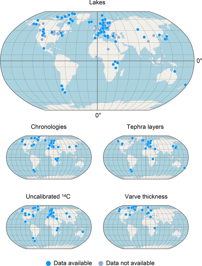
dent dating techniques or the frequent occurrence of tephra are located on all continents except Antarctica, with ∼ 56 %
layers. In total, 261 datasets for 95 of the identified lakes located in Europe, ∼ 26 % in North America, ∼ 8 % in Asia,
are available (September 2019) in public data repositories ∼ 5 % in Central America and South America, ∼ 3 % in
and were included in VARDA version 1.0. The datasets com- Africa, and ∼ 2 % in Oceania. The spatial coverage shows
prise of 70 individual chronologies from 43 lakes, 146 tephra a distinct spatial emphasis in lake distribution on the mid-
layers from 36 lakes, 118 uncalibrated 14 C records from latitudes of the Northern Hemisphere, especially the North
50 lakes, and 55 varve thickness records from 23 lakes. Ta- Atlantic realm. In contrast, only 13 of the 190 lake archives
ble 8 lists all identified lakes with their name, geographi- are located on the Southern Hemisphere.
cal coordinates, and available datasets, including the corre- Figure 4 presents the temporal distribution of datasets in-
sponding literature reference. cluded in VARDA 1.0. The combined chronologies span the
entire last glacial cycle with a minimum age range of 87 years
Earth Syst. Sci. Data, 12, 2311–2332, 2020 https://doi.org/10.5194/essd-12-2311-2020A. Ramisch et al.: VARDA (VARved sediments DAtabase) 2323
Figure 3. Spatial distribution of identified lakes and collected datasets included in VARDA 1.0. Data availability is indicated by blue-coloured
dots.
(from −60 to 27 BP) for Lake Woserin (Czymzik et al., 2016) 5 Data availability
and a maximal age range of 1 208 643 years (from 10 475 to
1 219 118 BP) for Lake Malawi (Ivory et al., 2018). However, All datasets are available online at
none of the chronologies entirely covers the last glacial cy- https://doi.org/10.5880/GFZ.4.3.2019.003 (Ramisch et al.,
cle on its own, illustrating the need to generate multisite net- 2019) in JavaScript Object Notation (JSON) format.
works to effectively cover long time periods for environmen- The benefit of this data format is its accurate depiction
tal reconstructions. For network synchronization purposes, of the VARDA data model, including the relationships
146 individual tephra layers reported for sediment composite between data nodes. Additionally, all datasets are also
profiles in 36 lakes were identified from the published liter- available in CSV format. The VARDA graph database
ature. A total of 30 tephra layers are reported as occurring and the user interface can be assessed online via the fol-
in more than one lake and are therefore suitable for synchro- lowing URL: https://varve.gfz-potsdam.de (last access:
nization. 15 September 2020). Support for VARDA is provided under
varve@gfz-potsdam.de.
https://doi.org/10.5194/essd-12-2311-2020 Earth Syst. Sci. Data, 12, 2311–2332, 20202324 A. Ramisch et al.: VARDA (VARved sediments DAtabase)
Figure 4. Temporal distribution of datasets in VARDA 1.0. (a) Age range of chronologies indicated by black bars, where each bar indicates
the coverage of an individual chronology. The NGRIP stable oxygen record (Andersen et al., 2004) with the GICC05 chronology (Vinther
et al., 2006; Rasmussen et al., 2006; Andersen et al., 2006; Svensson et al., 2005) is shown as a temporal reference curve. (b) Tephra layers
associated with lakes included in VARDA. Dots indicate the number of lakes associated with a single tephra layer. (c) Number of samples
per kiloyear bin of uncalibrated 14 C measurements. (d) Number of samples per kiloyear bin of individual varve thickness measurements.
6 Conclusion and future developments code of the database application will be made available for
the public in a separate contribution. In general, VARDA
is intended to be community-based effort, and we welcome
VARDA offers a user-friendly and time-efficient way to ex-
and encourage the participation of varve specialists and the
plore the multitude of palaeoenvironmental data from varved
broader palaeoenvironmental community for the further de-
lake archives. Due to the integration of precise chronologies
velopment and application of this tool.
and isochrones from tephra event layers into a modern graph
database, VARDA offers an easy way to construct regional to
global networks of palaeoenvironmental information. These Author contributions. AR coordinated the manuscript writing
multisite networks can be used e.g. to explore and analyse and wrote most parts, except Sect. 3, which was written by AlB and
leads and lags of regional climate change, large scale patterns MD. All authors contributed to manuscript writing. AlB, AR, and
in environmental variability or differentiated proxy responses AcB carried out the data compilation and designed the standard-
within and between archives. The first version of VARDA ization scheme with contributions from IN, MJB, JM, and NN for
presented here includes all technological requirements and tephrochronological data; RT, JM, FO, BP, and CB for 14 C data and
tools for future upgrades and developments. Presently, we are chronologies; and JM, FO, and RT for varve thickness data. AlB,
working on the integration of (1) an advanced visualization MD, and AR collected meta-information with contributions from
tool, (2) a user-friendly import application and (3) additional AcB, RT, IN, JM, BP, SP, and BB for the standardization of meta-
information. MD and AlB designed the graphical user interface for
proxy data such as stable isotopes and geochemical data, as
the database. MD implemented the user client and the server appli-
priority goals for the next update. Additionally, the source
Earth Syst. Sci. Data, 12, 2311–2332, 2020 https://doi.org/10.5194/essd-12-2311-2020A. Ramisch et al.: VARDA (VARved sediments DAtabase) 2325
cation with the help of MK. All authors reviewed the database and climate extending into the last interglacial period, Nature, 431,
provided valuable feedback. AcB and AR coordinated the project. 147–151, https://doi.org/10.1038/nature02805, 2004.
Andersen, K. K., Svensson, A., Johnsen, S. J., Rasmussen, S. O.,
Bigler, M., Röthlisberger, R., Ruth, U., Siggaard-Andersen, M.-
Competing interests. The authors declare that they have no con- L., Steffensen, J. P., Dahl-Jensen, D., Vinther, B. M., and
flict of interests. Clausen, H. B.: The Greenland Ice Core Chronology 2005, 15–
42 ka. Part 1: Constructing the time scale, Quaternary Sci. Rev.,
25, 3246–3257, https://doi.org/10.1016/j.quascirev.2006.08.002,
Special issue statement. This article is part of the special issue 2006.
“Paleoclimate data synthesis and analysis of associated uncertainty Ariztegui, D., Bösch, P., and Davaud, E.: Dominant ENSO frequen-
(BG/CP/ESSD inter-journal SI)”. It is not associated with a confer- cies during the Little Ice Age in Northern Patagonia: The varved
ence. record of proglacial Lago Frías, Argentina, Quatern. Int., 161,
46–55, https://doi.org/10.1016/j.quaint.2006.10.022, 2007.
Atsawawaranunt, K., Comas-Bru, L., Amirnezhad Mozhdehi, S.,
Deininger, M., Harrison, S. P., Baker, A., Boyd, M., Kaushal,
Acknowledgements. This work was supported by German Fed-
N., Ahmad, S. M., Ait Brahim, Y., Arienzo, M., Bajo, P.,
eral Ministry of Education and Research (BMBF) as a Research
Braun, K., Burstyn, Y., Chawchai, S., Duan, W., Hatvani, I.
for Sustainability initiative (FONA; http://www.fona.de, last access:
G., Hu, J., Kern, Z., Labuhn, I., Lachniet, M., Lechleitner, F.
15 September 2020) through the Palmod project. We thank Pierre
A., Lorrey, A., Pérez-Mejías, C., Pickering, R., Scroxton, N.,
Francus and an anonymous reviewer for their constructive feedback
and SISAL Working Group Members: The SISAL database:
on an earlier version of the manuscript. We also like to thank Malte
a global resource to document oxygen and carbon isotope
Räuchele, Laura Schley, Konstantin Mittelbach, Anna Beer, Helena
records from speleothems, Earth Syst. Sci. Data, 10, 1687–1713,
Rollmann, Ole Tölle, Vincent Moll, and Robert Keil for their valu-
https://doi.org/10.5194/essd-10-1687-2018, 2018.
able support in the data compilation and graph database generation.
Bakke, J., Dahl, S. O., Paasche, Ø., Løvlie, R., and
Nesje, A.: Glacier fluctuations, equilibrium-line altitudes
and palaeoclimate in Lyngen, northern Norway, during
Financial support. This research has been supported by the Bun- the Lateglacial and Holocene, Holocene, 15, 518–540,
desministerium für Bildung und Forschung (grant no. 01LP1510A). https://doi.org/10.1191/0959683605hl815rp, 2005.
Balascio, N. L., Zhang, Z., Bradley, R. S., Perren, B., Dahl, S. O.,
and Bakke, J.: A multi-proxy approach to assessing isolation
Review statement. This paper was edited by David Carlson and basin stratigraphy from the Lofoten Islands, Norway, Quaternary
reviewed by Pierre Francus and one anonymous referee. Res., 75, 288–300, https://doi.org/10.1016/j.yqres.2010.08.012,
2011.
Bendle, J. M., Palmer, A. P., Thorndycraft, V. R., and
Matthews, I. P.: High-resolution chronology for deglacia-
References tion of the Patagonian Ice Sheet at Lago Buenos Aires
(46.5◦ S) revealed through varve chronology and Bayesian
Allen, J. R. M., Brandt, U., Brauer, A., Hubberten, H.-W., Hunt- age modelling, Quaternary Sci. Rev., 177, 314–339,
ley, B., Keller, J., Kraml, M., Mackensen, A., Mingram, J., https://doi.org/10.1016/j.quascirev.2017.10.013, 2017.
Negendank, J. F. W., Nowaczyk, N. R., Oberhänsli, H., Berke, M. A., Johnson, T. C., Werne, J. P., Grice, K., Schouten, S.,
Watts, W. A., Wulf, S., and Zolitschka, B.: Rapid environmental and Sinninghe Damsté, J. S.: Molecular records of climate vari-
changes in southern Europe during the last glacial period, Nature, ability and vegetation response since the Late Pleistocene in the
400, 740–743, https://doi.org/10.1038/23432, 1999. Lake Victoria basin, East Africa, Quaternary Sci. Rev., 55, 59–
Amann, B., Szidat, S., and Grosjean, M.: A millennial-long record 74, https://doi.org/10.1016/j.quascirev.2012.08.014, 2012.
of warm season precipitation and flood frequency for the Bertrand, S., Castiaux, J., and Juvigné, E.: Tephrostratigraphy of
North-western Alps inferred from varved lake sediments: im- the late glacial and Holocene sediments of Puyehue Lake (South-
plications for the future, Quaternary Sci. Rev., 115, 89–100, ern Volcanic Zone, Chile, 40◦ S), Quaternary Res., 70, 343–357,
https://doi.org/10.1016/j.quascirev.2015.03.002, 2015. https://doi.org/10.1016/j.yqres.2008.06.001, 2008.
Andersen, K. K., Azuma, N., Barnola, J. M., Bigler, M., Biscaye, P., Bird, B. W., Abbott, M. B., Finney, B. P., and Kutchko, B.:
Caillon, N., Chappellaz, J., Clausen, H. B., Dahl-Jensen, D., Fis- A 2000 year varve-based climate record from the cen-
cher, H., Flückiger, J., Fritzsche, D., Fujii, Y., Goto-Azuma, K., tral Brooks Range, Alaska, J. Paleolimnol., 41, 25–41,
Grønvold, K., Gundestrup, N. S., Hansson, M., Huber, C., Hvid- https://doi.org/10.1007/s10933-008-9262-y, 2008.
berg, C. S., Johnsen, S. J., Jonsell, U., Jouzel, J., Kipfstuhl, S., Blaauw, M. and Christeny, J. A.: Flexible paleoclimate age-depth
Landais, A., Leuenberger, M., Lorrain, R., Masson-Delmotte, V., models using an autoregressive gamma process, Bayesian Anal.,
Miller, H., Motoyama, H., Narita, H., Popp, T., Rasmussen, S. O., 6, 457–474, https://doi.org/10.1214/11-BA618, 2011.
Raynaud, D., Rothlisberger, R., Ruth, U., Samyn, D., Schwan- Blaauw, M., van Geel, B., Kristen, I., Plessen, B., Lyaruu, A., En-
der, J., Shoji, H., Siggard-Andersen, M. L., Steffensen, J. P., gstrom, D. R., van der Plicht, J., and Verschuren, D.: High-
Stocker, T., Sveinbjörnsdóttir, A. E., Svensson, A., Takata, M., resolution 14 C dating of a 25,000-year lake-sediment record
Tison, J. L., Thorsteinsson, T., Watanabe, O., Wilhelms, F., and
White, J. W. C.: High-resolution record of Northern Hemisphere
https://doi.org/10.5194/essd-12-2311-2020 Earth Syst. Sci. Data, 12, 2311–2332, 20202326 A. Ramisch et al.: VARDA (VARved sediments DAtabase)
from equatorial East Africa, Quaternary Sci. Rev., 30, 3043– Cuven, S., Francus, P., and Lamoureux, S.: Mid to Late
3059, https://doi.org/10.1016/j.quascirev.2011.07.014, 2011. Holocene hydroclimatic and geochemical records from
Brauer, A. and Casanova, J.: Chronology and depositional the varved sediments of East Lake, Cape Bounty, Cana-
processes of the laminated sediment record from Lac dian High Arctic, Quaternary Sci. Rev., 30, 2651–2665,
d’Annecy, French Alps, J. Paleolimnol., 25, 163–177, https://doi.org/10.1016/j.quascirev.2011.05.019, 2011.
https://doi.org/10.1023/a:1008136029735, 2001. Czymzik, M., Brauer, A., Dulski, P., Plessen, B., Naumann, R.,
Brauer, A., Endres, C., Zolitschka, B., and FW Negen- von Grafenstein, U., and Scheffler, R.: Orbital and so-
dank, J.: AMS Radiocarbon and Varve Chronology lar forcing of shifts in Mid- to Late Holocene flood in-
from the Annually Laminated Sediment Record of Lake tensity from varved sediments of pre-alpine Lake Am-
Meerfelder Maar, Germany, Radiocarbon, 42, 355–368, mersee (southern Germany), Quaternary Sci. Rev., 61, 96–110,
https://doi.org/10.1017/s0033822200030307, 2000. https://doi.org/10.1016/j.quascirev.2012.11.010, 2013.
Brauer, A., Hajdas, I., Blockley, S. P. E., Bronk Ramsey, C., Czymzik, M., Dreibrodt, S., Feeser, I., Adolphi, F., and
Christl, M., Ivy-Ochs, S., Moseley, G. E., Nowaczyk, N. N., Brauer, A.: Mid-Holocene humid periods reconstructed
Rasmussen, S. O., Roberts, H. M., Spötl, C., Staff, R. A., from calcite varves of the Lake Woserin sediment
and Svensson, A.: The importance of independent chronology record (north-eastern Germany), Holocene, 26, 935–946,
in integrating records of past climate change for the 60–8 ka https://doi.org/10.1177/0959683615622549, 2016.
INTIMATE time interval, Quaternary Sci. Rev., 106, 47–66, Dean, W. E. and Megard, R. O.: Environment of deposition of
https://doi.org/10.1016/j.quascirev.2014.07.006, 2014. CaCO3 in Elk Lake, Minnesota, in: Elk Lake, Minnesota: Ev-
Brauer, A., Haug, G. H., Dulski, P., Sigman, D. M., and Negen- idence for Rapid Climate Change in the North-Central United
dank, J. F. W.: An abrupt wind shift in western Europe at the on- States, Geological Society of America, vol. 276, 97–114,
set of the Younger Dryas cold period, Nat. Geosci., 1, 520–523, https://doi.org/10.1130/spe276-p97, 1993.
https://doi.org/10.1038/ngeo263, 2008. Diedrich, K. E. and Loso, M. G.: Transient impacts of Little Ice Age
Bronk Ramsey, C.: Deposition models for chronological records, glacier expansion on sedimentation processes at glacier-dammed
Quaternary Sci. Rev., 27, 42–60, 2007. Iceberg Lake, southcentral Alaska, J. Paleolimnol., 48, 115–132,
Chassiot, L., Chapron, E., Di Giovanni, C., Albéric, P., https://doi.org/10.1007/s10933-012-9614-5, 2012.
Lajeunesse, P., Lehours, A.-C., and Meybeck, M.: Ex- Dietze, E., Brykała, D., Schreuder, L. T., Jażdżewski, K., Blar-
treme events in the sedimentary record of maar Lake quez, O., Brauer, A., Dietze, M., Obremska, M., Ott, F.,
Pavin: Implications for natural hazards assessment in the Pieńczewska, A., Schouten, S., Hopmans, E. C., and Słow-
French Massif Central, Quaternary Sci. Rev., 141, 9–25, iński, M.: Human-induced fire regime shifts during 19th century
https://doi.org/10.1016/j.quascirev.2016.03.020, 2016. industrialization: a robust fire regime reconstruction using north-
Clark, J. S., Merkt, J., and Muller, H.: Post-Glacial Fire, ern Polish lake sediments, https://doi.org/10.31223/osf.io/c9z4y,
Vegetation, and Human History on the Northern Alpine 2019.
Forelands, South-Western Germany, J. Ecol., 77, 897, Dörfler, W., Feeser, I., van den Bogaard, C., Dreibrodt, S., Er-
https://doi.org/10.2307/2260813, 1989. lenkeuser, H., Kleinmann, A., Merkt, J., and Wiethold, J.: A
Clement, A. C. and Peterson, L. C.: Mechanisms of abrupt climate high-quality annually laminated sequence from Lake Belau,
change of the last glacial period, Rev. Geophys., 46, RG4002, Northern Germany: Revised chronology and its implications for
https://doi.org/10.1029/2006RG000204, 2008. palynological and tephrochronological studies, Holocene, 22,
Colman, S. M., Rosenbaum, J. G., Kaufman, D. S., Dean, W. E., 1413–1426, https://doi.org/10.1177/0959683612449756, 2012.
and McGeehin, J. P.: Radiocarbon ages and age models Dräger, N., Theuerkauf, M., Szeroczyńska, K., Wulf, S.,
for the past 30,000 years in Bear Lake, Utah and Idaho, Tjallingii, R., Plessen, B., Kienel, U., and Brauer, A.:
in: Paleoenvironments of Bear Lake, Utah and Idaho, and Varve microfacies and varve preservation record of cli-
its catchment, Geological Society of America, vol. 450, mate change and human impact for the last 6000 years
https://doi.org/10.1130/2009.2450(05), 2009. at Lake Tiefer See (NE Germany), Holocene, 27, 450–464,
Cook, T. L., Bradley, R. S., Stoner, J. S., and Francus, P.: Five https://doi.org/10.1177/0959683616660173, 2016.
thousand years of sediment transfer in a high arctic watershed Eden, D. N. and Page, M. J.: Palaeoclimatic implications of
recorded in annually laminated sediments from Lower Murray a storm erosion record from late Holocene lake sediments,
Lake, Ellesmere Island, Nunavut, Canada, J. Paleolimnol., 41, North Island, New Zealand, Palaeogeogr. Palaeocl., 139, 37–58,
77–94, https://doi.org/10.1007/s10933-008-9252-0, 2008. https://doi.org/10.1016/s0031-0182(97)00136-3, 1998.
Corella, J. P., Moreno, A., Morellón, M., Rull, V., Giralt, S., Elbert, J., Jacques-Coper, M., Van Daele, M., Urrutia, R.,
Rico, M. T., Pérez-Sanz, A., and Valero-Garcés, B. L.: Cli- and Grosjean, M.: A 600 years warm-season tempera-
mate and human impact on a meromictic lake during the last ture record from varved sediments of Lago Plomo, North-
6,000 years (Montcortès Lake, Central Pyrenees, Spain), J. ern Patagonia, Chile (47◦ S), Quatern. Int., 377, 28–37,
Paleolimnol., 46, 351–367, https://doi.org/10.1007/s10933-010- https://doi.org/10.1016/j.quaint.2015.01.004, 2015.
9443-3, 2010. Engels, S., van Geel, B., Buddelmeijer, N., and Brauer, A.:
Courtney Mustaphi, C. J. and Gajewski, K.: Holocene sedi- High-resolution palynological evidence for vegetation re-
ments from a coastal lake on northern Devon Island, Nunavut, sponse to the Laacher See eruption from the varved
Canada, edited by O. Lian, Can. J. Earth Sci., 50, 564–575, record of Meerfelder Maar (Germany) and other central
https://doi.org/10.1139/cjes-2012-0143, 2013. European records, Rev. Palaeobot. Palyno., 221, 160–170,
https://doi.org/10.1016/j.revpalbo.2015.06.010, 2015.
Earth Syst. Sci. Data, 12, 2311–2332, 2020 https://doi.org/10.5194/essd-12-2311-2020You can also read