With implications for river restoration The impact of beaver dams on the morphology of a river in the Eastern U.S.
←
→
Page content transcription
If your browser does not render page correctly, please read the page content below
See discussions, stats, and author profiles for this publication at: https://www.researchgate.net/publication/261107172

The impact of beaver dams on the morphology of a river in the Eastern U.S.
with implications for river restoration

Article in Earth Surface Processes and Landforms · July 2014
DOI: 10.1002/esp.3576

CITATIONS                                                                                              READS

17                                                                                                     493

2 authors:

            Joanna Crowe Curran                                                                                   Kristen Cannatelli
            University of Tennessee                                                                               University of Virginia
            46 PUBLICATIONS 1,248 CITATIONS                                                                       3 PUBLICATIONS 44 CITATIONS

                SEE PROFILE                                                                                          SEE PROFILE

 All content following this page was uploaded by Joanna Crowe Curran on 03 April 2019.

 The user has requested enhancement of the downloaded file.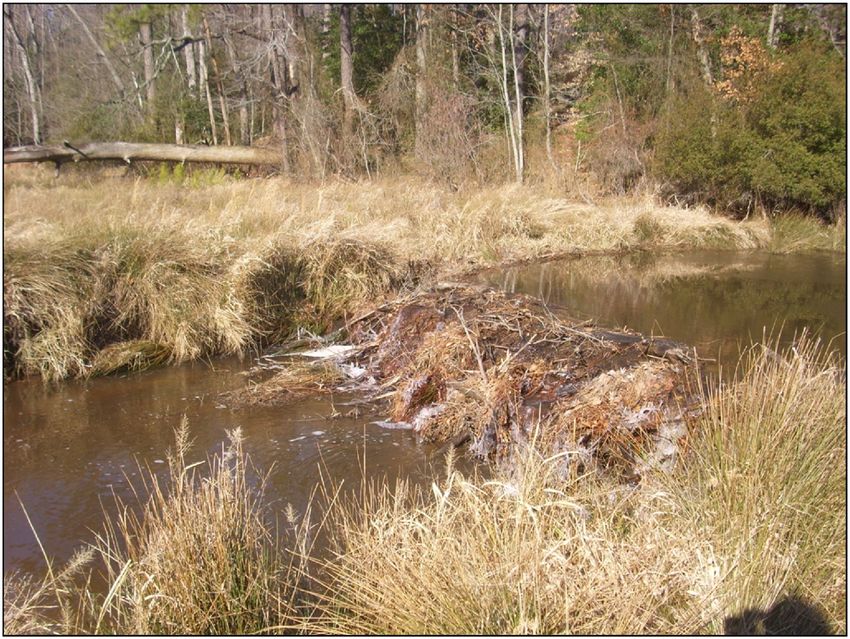
EARTH SURFACE PROCESSES AND LANDFORMS
Earth Surf. Process. Landforms 39, 1236–1244 (2014)
Copyright © 2014 John Wiley & Sons, Ltd.
Published online 16 April 2014 in Wiley Online Library
(wileyonlinelibrary.com) DOI: 10.1002/esp.3576

The impact of beaver dams on the morphology of a
river in the eastern United States with implications
for river restoration
Joanna Crowe Curran1* and Kristen M. Cannatelli1,2
1
  Department of Civil and Environmental Engineering, University of Virginia, Charlottesville, VA USA
2
  Interfluve Environmental, Cambridge, MA USA

Received 12 March 2013; Revised 15 March 2014; Accepted 20 March 2014

*Correspondence to: Joanna Crowe Curran, Department of Civil and Environmental Engineering, University of Virginia, PO Box 400742, Charlottesville, VA 22904, USA.
E-mail: curran@virginia.edu

ABSTRACT: Restoration projects in the United States typically have among the stated goals those of increasing channel stability
and sediment storage within the reach. Increased interest in ecologically based restoration techniques has led to the consideration
of introducing beavers to degraded channels with the hope that the construction of beaver dams will aggrade the channel. Most
research on beaver dam modification to channels has focused on the long-term effects of beavers on the landscape with data primarily
from rivers in the western United States. This study illustrated that a role exists for beavers in the restoration of fine-grained, low
gradient channels.
   A channel on the Atlantic Coastal Plain was analyzed before, during, and after beaver dams were constructed to evaluate the lasting
impact of the beaver on channel morphology. The channel was actively evolving in a former reservoir area upstream of a dam break.
Colonization by the beaver focused the flow into the channel, allowed for deposition along the channel banks, and reduced the chan-
nel width such that when the beaver dams were destroyed in a flood, there was no channel migration and net sediment storage in the
reach had increased. However, the majority of the deposition occurred at the channel banks, narrowing the channel width, while the
channel incised between sequential beaver dams. The study indicated that where channels are unstable laterally and bank erosion is a
concern, the introduction of beavers can be a useful restoration tool. However, because of the likelihood of increased channel bed
erosion in a reach with multiple beaver dams, they may not be the best solution where aggradation of an incised channel bed is
the desired result. Copyright © 2014 John Wiley & Sons, Ltd.
KEYWORDS: beaver dam; restoration; bank stability

Introduction                                                                        (Palmer et al., 2009; Burchsted et al., 2010). Potential applica-
                                                                                    tion of beavers has focused on incised rivers in the western
A purpose of many stream restoration projects is to raise the                       United States, as evidenced by a recent short course in Utah
longitudinal profile of a degraded channel bed and to reconnect                     (www.beaver.joewheaton.org). However, the beaver population
the active channel to its floodplain (e.g. Palmer et al., 2005).                    in the eastern United States has been growing (Harrelson, 1998;
These are channels that have eroded vertically, incising into                       Burchsted and Daniels, 2014), making the wide-spread applica-
their beds as a consequence of hydromodification in the                             tion of beaver to a broader range of river restoration projects
contributing area. One popular restoration method has been                          possible.
to install a series of low head check dams which reduce                                Dam removal has become a part of many river restoration
hydrograph peaks and induce deposition upstream of each                             projects, particularly where the dams are low-head mill dams
dam (e.g. Wilcox et al., 2001). Channel spanning beaver dams                        that no longer serve a purpose, are structurally unsound, and
can affect channel morphology in much the same manner as                            represent a local flooding hazard. Removing a low-head dam
engineered check dams. Ponding upstream of beaver dams                              remains controversial due to uncertainties regarding the antici-
increases the local water depth, reduces flow velocities, and                       pated export of accumulated fine sediment from the reservoir
dissipates stream energy which in turn induces deposition of                        area as the impoundment reverts to a channel. Because fine
suspended sediment and channel aggradation upstream of the                          sediments are building components of beaver dams along with
dams (Naiman et al., 1986; Butler and Malanson, 1995; Pollock                       wood and stones (Gurnell, 1998), beavers have promise in the
et al., 2007; Green and Westbrook, 2009). The ability of beaver                     restoration of these river systems. Beavers have the potential to
dams to affect aggradation of an incised stream channel                             construct temporary dams that may help stabilize the channel
has made them an attractive option for restoration that is                          forming in the former reservoir area and limit the export of fine
ecologically based and requiring minimal human intervention                         sediment. Thus, the addition of beaver dams may provide a
IMPACT OF BEAVER DAMS 1237
natural way to enhance emergent channel stability so that Jones, 1995; Jones et al., 1997). There have been a limited
structurally unsound dams may be removed. number of attempts to reintroduce beavers in specific locations
Despite increases in beaver population and the potential for with the intention that the beavers would modify the existing
application of beaver in the restoration of Atlantic Coastal Plain landscape by aggrading a degraded river and improving the
channels, data from this region remains limited. For the beaver riparian ecosystem. Both the North American Beaver (Castor
to become a widely viable restoration option, the impact canadensis) and the European Beaver (Castor fiber) have been
of beaver dams on sedimentation rates, channel morphology, introduced to landscapes for restoration purposes (Gorshkov
and channel stability needs to be quantified across a diversity et al., 1999; Nyssen et al., 2011). The use of beavers as part
of study areas. This paper presents a case study of the impacts of channel stabilization and riparian restoration efforts in North
of beaver dams on a low gradient, fine-grained alluvial channel America dates to the 1930s when 500–600 beavers were
on the Atlantic Coastal Plain. A human-built dam on a river in released into areas where Civilian Conservation Corps workers
eastern Virginia was breached. As a channel developed in the had built initial dam structures in Idaho, Utah, Oregon,
former reservoir area, beaver inhabited the area and built a Washington, and Wyoming (Ruedemann and Schoonmaker,
series of dams. Channel morphology was measured before, 1938). More recently, beavers were introduced to 14 different
during, and after the beaver dams were present, enabling an streams in Wyoming to improve habitats for waterfowl, and
analysis of the impacts of beaver dams on channel morphology within one year of their introduction, they had created 31
and sediment retention in the former reservoir and an evalua- ponds (McKinstry and Anderson, 2002). Three to five years af-
tion of the applicability of existing models of sediment aggrada- ter the introduction of 23 beavers in seven riparian rehabilita-
tion at beaver dams. This study contributes to the assessment of tion areas in New Mexico, increases in water table levels and
beavers as a restoration option by presenting data from a low riparian vegetation were measured and attributed to the pres-
gradient system following dam removal. We evaluate the con- ence of beaver dams (Albert and Trimble, 2000). Recent studies
tribution of beaver dams to channel stability and sediment re- have linked beaver dam characteristics with changes in chan-
tention, two common goals in river restoration. nel flows. In western Colorado, the ponds formed upstream of
high-head (greater than 1.2 m) beaver dams had a morphology
that led to cool bottom waters. The ponds were deep but with a
Background small surface area, and water leaving the ponds reduced tem-
peratures in the downstream channel and also in shallow
Beaver dams built within the main channel punctuate the lon- groundwater flowpaths (Fuller and Peckarsky, 2011). This find-
gitudinal river profile and cause the channel to flow through a ing contributed to defining the appropriate use of beavers to
series of impoundments joined by free flowing reaches enhance stream cooling for trout habitat (Collen and Gibson,
(Burchsted et al., 2010). Multiple dams of different heights are 2001; Fuller and Peckarsky, 2011). The rise in groundwater
often built on a single river channel, creating a range of tables around beaver dams has led to suggestions that for broad
impounded water levels to accommodate multiple beaver recovery of riparian willow stands in Yellowstone National Park,
lodge entrances (Gurnell, 1998). Backwater upstream from the beaver must re-colonize the area (Marshall et al., 2013).
beaver dams can increase groundwater levels and create suit- The desired time frame for beaver dam use in channel resto-
able environments for emergent vegetation (Collen and Gibson, ration is in part a function of the aggradation rate in the ponds.
2001; Westbrook et al., 2006). As vegetation establishes in Widespread prescribed use of beavers to aggrade an incised
beaver impoundments, accumulating sediment is stabilized in river channel requires predictive models of beaver induced ag-
place. Reduced reservoir space in beaver impoundments in- gradation rates and volumes. Beaver dams can aid in channel
creases the rate of overbank flooding, re-routing the flow into bed aggradation and riparian area regeneration during a resto-
multiple canals and channels (Woo and Waddington, 1990; ration project but be undesirable over the long term because of
Burchsted et al., 2010; Westbrook et al., 2011). Overbank flows the possibility of channel avulsions and multi-thread channel
may lead to main channel avulsions, the formation of diversion formation. Most studies that have estimated sedimentation vol-
channels on floodplains, and stable multi-thread channel sys- umes and rates associated with beaver ponds have focused on
tems with vegetation occupying the areas between the channel the historical alteration to the landscape as a consequence of
threads (Woo and Waddington, 1990). Floodplains develop di- beaver removal. The result has been widely divergent estimates
versity in vegetation and channel morphology, creating hetero- of the sediment volumes retained by beaver dams in the past.
geneity in the physical and biological components of the For example, sediment accumulation prior to the removal of
riparian corridor (Townsend and Butler, 1996; Burchsted and 18 beaver dams in the Purcell Mountains in south-eastern
Daniels, 2014). Through this process, landscapes with active British Columbia in the 1980s was estimated to be between
beaver populations can be transformed into beaver meadows 290 m3 and 406 m3 over a 3 km reach (Green and Westbrook,
comprised of multi-thread channels in low gradient valleys 2009). By extrapolating from measured sediment depths at six
(Ruedemann and Schoonmaker, 1938; Ives, 1942; Naiman beaver dams in Nebraska, 1450 m3 of sediment was estimated
et al., 1988; Hay, 2010; Westbrook et al., 2011; Polvi and Wohl, as having been stored over 736 km of river channel
2012). The multi-thread channel structure characteristic of (McCullough et al., 2004). Sedimentation rates from eastern
these meadows is maintained by the presence of multiple bea- North America are available only for the boreal forest areas of
ver dams and the planform stability of these channels has been sub-arctic Quebec (Naiman et al., 1986; Naiman et al., 1988),
attributed to the presence of the beaver dams (Townsend and where the surface areas of the beaver ponds were used as an
Butler, 1996). After beaver dams were removed from an area indication of sediment volume in the pond. The average esti-
in British Columbia, the meadow landscape adjusted to a nar- mate was an accumulation of 1000 m3 of sediment per beaver
row, single thread channel (Green and Westbrook, 2009). An pond from which the authors extrapolated that under the his-
alteration in landscape upon loss of active beavers has also toric beaver population sediment retention in the watershed
been related to decreases in groundwater levels and the subse- was equal to a depth of 42 cm over the watershed area.
quent loss of robust willow populations (Marshall et al., 2013). Existing empirical models that predict aggradation rate were
The ability to modify the physical characteristics and species developed using data from channels in the mid-western
richness of a habitat around its needs has led to the characteri- (Naiman et al., 1986) and western United States (Butler and
zation of the beaver as an ‘ecosystem engineer’ (Lawton and Malanson, 1995; Pollock et al., 2007). Butler and Malanson (1995)
Copyright © 2014 John Wiley & Sons, Ltd. Earth Surf. Process. Landforms, Vol. 39, 1236–1244 (2014)1238 J. C. CURRAN AND K. M. CANNATELLI
compared measurements of aggradation at beaver dams to sed- Coastal Plain, where rivers are dominated by fine-grained
imentation volumes at eight ponds in Montana. They found that alluvial and have low gradients (Meade, 1982; Hupp, 2000).
channel bed slope had a strong influence on pond sedimenta- Sediments in the study reach were predominantly fine-grained
tion rates, reflecting the importance of beaver dam height and with median particle sizes between 0.2 and 0.5 mm. The median
shape for sediment accretion. Combining their measured sedi- channel slope was 0.002 m/m.
mentation data with estimates of beaver dam age, the authors Kimages creek was dammed in 1927 when a 3 m high, 50 m
developed Equation (1) to predict the average sedimentation wide earthen dam was built to create a 72.4 ha impoundment
rate using the age of the pond, where AR is the aggradation rate to increase fishing and recreation opportunities in the area
in centimeters per year and age is measured in years. (Dougherty, 2008). The dam remained in place for 79 years un-
til the left side was breached following a large storm in October
lnðAR Þ ¼ 2:99 0:71 lnðage Þ (1) 2006. As the reservoir drained, new reaches of Kimages Creek
evolved in the former impoundment. In late July or early August
Using aggradation rates and volumes measured upstream of 2008, beaver dams were constructed in the channel at loca-
13 beaver dams in the Columbia River Valley in Oregon that tions B105, B170, and B185 downstream from the uppermost
ranged in age from one to six years, Pollock et al. (2007) devel- extent of the former reservoir (Figure 1). The beaver dams
oped a similar empirical model to relate the age of the dam to varied in height between 0.5 and 2.1 m and all extended across
the rate of sedimentation in the upstream pond: the channel width, as illustrated by the dam at B105 m
(Figure 2). The beavers were not introduced to the area, and
lnðAR Þ ¼ 0:96 0:9093 lnðage Þ (2) the dams were constructed without any outside intervention.
The beaver dams remained in place until being destroyed by
where AR is the aggradation rate in meters per year and age is a two-year return interval storm event on November 15, 2009
measured in years. We present the Pollock model in a similar that was accompanied by a number of smaller events such that
format as Equation (1) to illustrate the similarity in the models. the area was inundated for approximately a month. Flow rates
Both models predict maximum sedimentation rates immedi- on Kimages Creek were correlated to flows measured at the
ately after dam formation with rates decreasing with time. Chickahominy gage, which is the closest US Geographical
Survey (USGS) gage to the study site and provided a continuous
flow record from 1942 to present (Figure 3).
Study Site
Kimages Creek is a second-order tributary to the James River in Methods
eastern Virginia (Figure 1). The Creek drains an area of 10.55 km2
where land cover is a mix of forest (70%), shrub vegetation Channel morphology was evaluated from July 2007 and Janu-
(11%), wetlands (12%) and cultivation/development (7%) ary 2010 through cross-section surveys at 104 m, 142 m, 172
(NOAA Coastal Services Center, 2009). Undisturbed forests m, and 198 m (Figure 1). Cross-sections were measured using
and agricultural fields are immediately adjacent to the study a Topcon Total Station GTS-230W or a level and stadia rod. A
reach, which has not experienced significant land-use change polyvinylchloride (PVC) marker was placed at each cross-section
in the past 100 years. Kimages Creek is typical of the Eastern to aid in identifying repeat survey locations between field
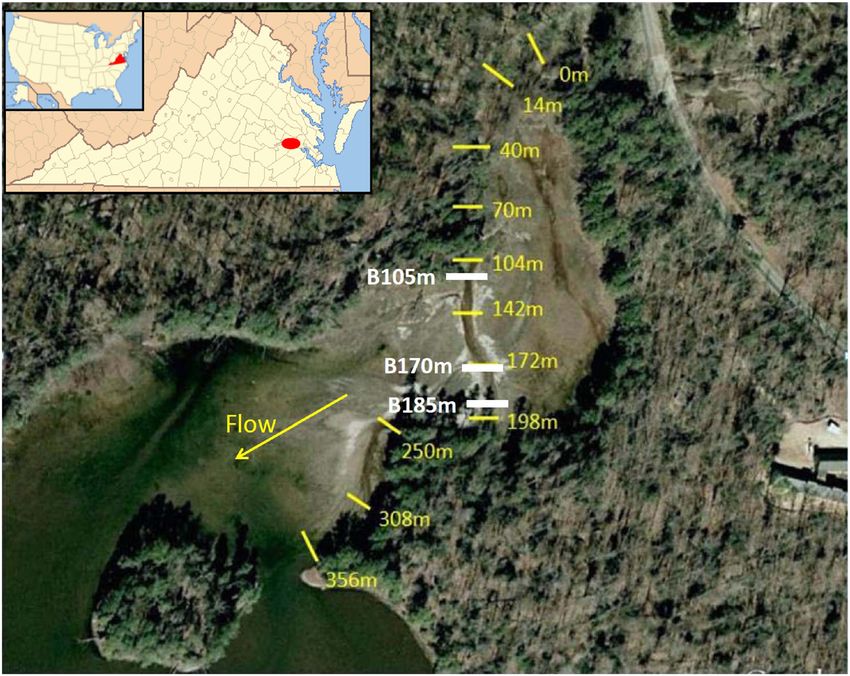
Figure 1. Study area with locations of permanent cross-sections marked by thin yellow lines and cross-section labels to the right of the marker.
Beaver dam locations are marked by thick white lines and labels to the left of the lines. The beaver dam sites are labeled with the letter B at the
beginning of each identifier. The man built dam is approximately 1300 m downstream of the area shown. The inset in the upper left shows the location
of the study area in Virginia. The base image is from the Virginia Geographic Information Network, courtesy of the Commonwealth of Virginia, and the
inset of the state of Virginia was created from the ESRI database. Kimages Creek is located at 37°20’11.91"N; 77°12’24.47"W. This figure is available in
colour online at wileyonlinelibrary.com/journal/espl
Copyright © 2014 John Wiley & Sons, Ltd. Earth Surf. Process. Landforms, Vol. 39, 1236–1244 (2014)IMPACT OF BEAVER DAMS 1239
Results
The impact of a beaver dam on the upstream channel area was
measured at the 104 m cross-section. The beaver dam built in
July 2008 at B105 was 2.1 m high and 7.62 m wide, spanning
the channel and increasing the height of the left bank by over
half a meter. This was the largest of the beaver dams in the
study reach. Within the first months of dam formation, there
was spatially even aggradation of the channel bed as fine sed-
iments traveling downstream were deposited in the newly
formed beaver pond (Figure 4a; Table I). The bankfull area
was only slightly reduced by channel aggradation because de-
position on the channel bed was offset by an increase in bank
height. Channel bed aggradation continued upstream of the
dam at B105, but was spatially uneven between the October
2008 and January 2009 surveys (Figure 4a). The left side of
the channel bed aggraded more than the right, indicating the
Figure 2. Photograph of the beaver dam at B105. Cross-section 104 beginning of channel narrowing and deepening. Sediments
was measured just upstream in the beaver pond. The beaver dam was
continued to deposit on the left side of the channel, reducing
7.6 m wide and 1.3 m high (photograph taken on January 9, 2009]. This
figure is available in colour online at wileyonlinelibrary.com/journal/espl overall channel width by almost 2 m and increasing the median
grain sizes of the channel bed and banks (Table I), until the bea-
ver dam was broken in November 2009. The final cross-section
campaigns. Data collected prior to August 2008 illustrated the
morphology measured in January 2010 was of a deep, narrow
channel morphology before beaver dam formation and have
channel with an adjacent, shallower overflow channel. The
been described in Cannatelli and Curran (2012). Later surveys
measured the impact of the beaver dams on the channel form. bankfull area of the main channel was greatly reduced by a
The locations of the cross-sections with respect to the beaver net accumulation of 0.14 m2 of sediment (Table I). The cross-
dams enabled an evaluation of channel changes immediately up- section did not migrate laterally and the bank locations
stream of the dam at B105 m, immediately downstream of the remained stable throughout the study period.
dam at B170, at a location approximately equidistant between Cross-section 142 was located on a fairly straight reach of the
dams at B105 and B170, and 13 m downstream of the dam se- channel, mid-way between the beaver dams at B105 and B170
quence (Table I). Cross-section surveys from January 2010 were (Figure 1). Thus, it was between the expected effects of a re-
measured two months after dam destruction and documented duced sediment supply downstream of the upstream dam and
the lasting impacts of beaver colonization on the channel. Bulk the backwater ponding effects from the downstream dam.
streambed and bank grain size samples were collected in 2008 Changes in cross-section morphology between initial beaver
and 2010 (Table I). A minimum sample size of 100 g was col- dam construction in July 2008 and the survey in October
lected at each site (Rice and Church, 1996). All samples were 2008 were limited to right bank erosion with minimal changes
returned to the laboratory, dried, and sieved into 0.5 Φ size frac- in overall bankfull area (Figure 4b; Table I). By January 2009,
tions. In 2008 additional sediment samples were collected and approximately six months after beaver dam construction, there
analyzed from a part of the Kimages Creek upstream of the back- had been a measurable increase in channel depth and lateral
water created by the dam. shift in the location of the channel thalweg, which identifies
The measured cross-sections were used to quantify changes the deepest point in the channel. The thalweg returned to its
in channel morphology between survey dates. Channel bed original location after the beaver dams were destroyed, during
and bank aggradation and erosion were evaluated by compar- which time there was also general bed degradation and fining.
ing total widths and depths as well as bankfull areas between Channel bank sediments became courser while the amount of
successive surveys (Table I). Bankfull was determined for the silt and clay fraction decreased (Table I). The January 2010 sur-
evolving channel cross-sections as the elevation of the lower vey showed cross-section 142 had developed a narrow, deep
channel bank at sites where a defined floodplain had not yet channel with stable banks and experienced a net loss of 1.63 m2
developed. Because the sediment was not evenly distributed of sediment, increasing in bankfull area (Table I).
longitudinally over the channel reach, we did not attempt to The downstream effects of beaver dam formation were mea-
extrapolate the measured sediment areas into volumes. sured at cross-section 172, located 2 m downstream of the
0.25
0.20
Discharge (cms)
0.15
0.10
0.05
0.00
Jan-06 May-06 Aug-06 Dec-06 Apr-07 Aug-07 Dec-07 Apr-08 Aug-08 Dec-08 Apr-09 Aug-09 Dec-09 Apr-10
Date
Figure 3. Hydrograph of flows through Kimages Creek from 2006 through April 2010. Field campaign dates are marked with x’s on the hydrograph.
Copyright © 2014 John Wiley & Sons, Ltd. Earth Surf. Process. Landforms, Vol. 39, 1236–1244 (2014)1240
Copyright © 2014 John Wiley & Sons, Ltd.
Table I. Details at measured cross-sections. All beaver dams were built in July 2008 and destroyed in November 2009
Thalweg Rate of change Aggradation rate Aggradation rate
Cross-section Location relative Survey Thalweg aggradation Bankfull in bankfull Channel bed Channel banks Per cent sediment predicted by predicted by
2 2
location to beaver dams dates depth (m) rate (m/yr) area (m ) area (m /yr) D50 (mm) D50 (mm) less than 0.062 mm Equation (1) (m/yr) Equation (2) (m/yr)
104 m Upstream of beaver 7.2008 1.30 8.28 0.21 0.12 9.3
dam at 105 m 8.2008 1.07 5.32 7.47 9.74 1.16 3.67
10.2008 1.51 1.74 8.74 7.65 0.53 1.35
1.2009 1.22 0.96 6.39 9.41 0.33 0.72
1.2010 0.98 0.63 2.66 3.74 0.28 0.20 10.0 0.15 0.27
142 m Between beaver dams 7.2008 0.35 1.20
at 105 m and 170 m 8.2008 0.65 0.48 0.88 3.84 0.48 0.09 20.4 1.16 3.67
10.2008 0.69 0.84 1.07 1.15 0.53 1.35
1.2009 0.83 1.72 2.06 3.97 0.33 0.72
1.2010 1.26 0.85 4.16 2.09 0.22 0.22 4.7 0.15 0.27
172 m Downstream of beaver 7.2008 0.41 1.32
dam at 170 m 8.2008 0.39 1.08 1.32 0.07 0.40 0.09 11.7 1.16 3.67
10.2008 0.48 0.30 1.65 1.97 0.53 1.35
1.2009 0.43 1.96 1.89 0.33 0.72
J. C. CURRAN AND K. M. CANNATELLI
0.98
1.2010 0.92 0.08 2.81 0.91 0.22 0.22 4.2 0.15 0.27
198 m 13 m downstream of 7.2008 1.00 3.50
beaver dam sequence 8.2008 0.63 0.12 2.21 15.54 0.08 0.10 27.5 1.16 3.67
10.2008 0.64 2.76 1.06 6.86 0.53 1.35
1.2009 1.10 2.08 1.87 3.23 0.33 0.72
1.2010 0.58 0.58 1.07 0.80 0.26 0.32 1.8 0.15 0.27
Earth Surf. Process. Landforms, Vol. 39, 1236–1244 (2014)IMPACT OF BEAVER DAMS 1241
104m 142m
16.0 a 15.5 b
15.8 15.3
elevation above msl (m)
elevation above msl (m)
15.6 15.1
15.4 14.9
15.2 Jul-08 14.7 Apr-08
15.0 Aug-08 14.5 Aug-08
14.8 Oct-08 14.3 Oct-08
14.6 Jan-09 14.1 Jan-09
14.4 Jan-10 13.9 Jan-10
14.2 13.7
14.0 13.5
0 5 10 15 0 2 4 6 8 10
lateral distance across channel (m) lateral distance across channel (m)
172m 198m
15.0 c 15.4 d
15.2
elevation above msl (m)
elevation above msl (m)
14.8
15.0
14.6 14.8
Apr-08 Jul-08
14.6
14.4 Aug-08 Aug-08
14.4
Oct-08 Oct-08
14.2 14.2
Jan-09 Jan-09
14.0
14.0 Jan-10 Jan-10
13.8
13.8 13.6
4 5 6 7 8 9 10 6 7 8 9 10 11
lateral distance across channel (m) lateral distance across channel (m)
Figure 4. Surveyed channel cross-sections. (a) 104 m, immediately upstream of dam B105; (b) 142 m, mid-distant between dams at B105 and B170;
(c) 172 m, immediately downstream of dam B170; (d) 198 m, 13 m downstream of the dam sequence. All dams were removed during a flood in No-
vember 2009. This figure is available in colour online at wileyonlinelibrary.com/journal/espl
second beaver dam. Within the first months of dam construc- deposited within the channel aggraded the bed by 0.6 m, making
tion in July 2008 the channel area eroded by 0.424 m2 which the channel depth equal to what it was in October 2008 (Table I).
shifted the location of the thalweg by approximately 1 m The reduction in bankfull area and aggradation of the channel
(Figure 4c; Table I). This initial erosion was attributed to beaver bed are attributed in part to the deposition of sediment previously
activity during dam building as beavers often utilize fine- stored behind the upstream beaver dam sequence. Channel bed
grained sediments in dam construction, and the erosion was and bank D50 values were measurably coarser in 2010 when
focused on the bank and not the channel bed as would have compared to the 2008 samples, indicating the influx of material
been the case if the erosion had resulted from bed scour. Depo- from upstream (Table I).
sition of 0.424 m2 returned the cross-section to its original size We used the thalweg data measured on Kimages Creek to
and shape by the October 2008 survey (Figure 4c). However, evaluate the applicability of available models of aggradation
between October 2008 and January 2009, the channel thalweg around beaver dams. Aggradation rates using Equation (1) (Butler
migrated laterally such that the channel location was similar to and Malanson, 1995) and Equation (2) (Pollock et al., 2007) were
that measured in August 2008 immediately following dam compared to measured rates of aggradation or erosion at each
construction. This was a temporary change in channel location cross-section (Table I). Both models calculated aggradation rate
and accompanied an increase in bankfull area. The survey in using the age of the beaver dam, and because all dams in
January 2010, after the removal of the beaver dams, showed Kimages Creek existed for the same time frame, the predicted
the channel had returned to its original position and the bed aggradation was constant across the cross-sections in both
had degraded by 0.5 m. Changes in the grain sizes of the bed models. Equation (2) predicted a total thalweg aggradation of
and banks were similar to those measured at cross-section 6.01 m at each cross-section which was approximately four
142. The bed experienced overall fining while the banks times the prediction of 2.17 m of thalweg aggradation using
coarsened. The final cross-section morphology had a bankfull Equation (1). In contrast, field measurements documented fluc-
area 0.38 m2 larger than prior to beaver dam presence and a tuations in thalweg depths with both aggradation and erosion at
smaller median grain size (Table I). each cross-section. The net change in channel thalweg eleva-
The downstream effects of the beaver dam sequence on tion over the time period of beaver dam presence ranged from
channel morphology were measured at cross-section 198, which maximum thalweg erosion of 0.42 m at cross-section 198 to
was 13 m downstream of the final beaver dam in the study reach. maximum thalweg aggradation of 0.91 m at cross-section 142.
The channel at this location was broad and flat prior to beaver Changes in thalweg elevation were more varied than either
dams construction, making identification of a bankfull area in model could predict as each cross-section experienced different
August 2008 difficult (Figure 4d; Table I). By the October survey, rates of aggradation and erosion between surveys.
after the upstream beaver dams had been in place for approxi-
mately three months, the channel at 198 m had experienced
aggradation and developed a measureable channel area Discussion
(Figure 4d). The channel subsequently eroded by 0.72 m2 and
increased in bankfull area while the beaver dams were in place. The dams built on Kimages Creek remained in place for less than
However, after the beaver dams were destroyed in November two years, which recent studies have shown to be a common
2009, the channel area was measurably smaller as sediment length of time for the existence of a beaver dam on a modern
Copyright © 2014 John Wiley & Sons, Ltd. Earth Surf. Process. Landforms, Vol. 39, 1236–1244 (2014)1242 J. C. CURRAN AND K. M. CANNATELLI day channel (Bunte et al., 2011; Burchsted and Daniels, 2014; Channel grain size data indicate the accumulation of reser- Levine and Meyer, 2014). Although the channel was in place voir sediment on the channel bed within Kimages Creek was when the beaver dams were built, it had not formed a stable mor- temporary while the dams were in place. Grain size measure- phology as it had recently emerged from the reservoir backwater ments from a free flowing reach of Kimages Creek upstream (Cannatelli and Curran, 2012). Unconstrained channel formation of the reservoir backwater had an average D50 of 0.37 mm on in former reservoirs has been characterized by bank failures and the channel bed and an average D50 of 0.35 mm on the chan- frequent lateral channel migrations which have resulted in nel banks. Cross-sections 104, 142, and 172 had average bed erosion of former reservoir sediments (Doyle et al., 2003). At and bank grain sizes near these values in July 2008, prior to Kimages Creek beaver dams aided in stabilizing the channel form or immediately following beaver dam formation. While the by minimizing channel migration and allowing for aggradation at dams were in place, fine-grained reservoir sediment accumu- the banks, as evidenced by measured channel narrowing at all lated in the beaver ponds and over the reaches between dams. the cross-sections as sediment deposited onto the banks. The The same cross-sections experienced bed fining and increased stabilizing effect on channel morphology is also illustrated by similarity between bed and bank grain sizes as sediments from the decrease in cross-sectional bankfull area at 198 m (Table I) the former reservoir deposited within the reach. When the and the temporary nature of the lateral shift in channel thalweg dams broke, the accumulated sediments were transported position at cross-sections 142 and 172. downstream of the beaver dam sequence. The average grain The changes to Kimages Creek morphology were more size at cross-section 198 was much finer than the upstream varied than the scenario of beaver pond sedimentation leading cross-section initially but increased after the dams broke to be to channel avulsions, formation of multi-thread channels, and closer to the values measured upstream. Where channel sedi- eventual landscape aggradation that has been suggested by a ments have included cohesives, bed incision has been more number of studies of historic beaver populations (e.g. Woo common than channel widening following beaver dam re- and Waddington, 1990; Wright et al., 2002; Polvi and Wohl, moval (Burchsted and Daniels, 2014). Sediments in Kimages 2012). Morphology changes in Kimages Creek also showed Creek included silt and clay size fractions, although the propor- much more variability than model predictions of overall chan- tions decreased with the removal of the beaver dams. Channel nel aggradation by deposition of between 2.17 and 6.01 m at incision was documented and quantified by the changes in the beaver ponds. When the measured changes in the reach cross-sectional shape during and after beaver dam presence were summed, there was 1.18 m2 of net sediment storage in in Kimages Creek. Kimages Creek while the beaver dams were in place and The contribution of temporary beaver dams to stabilize bank 2.43 m2 of net storage after they broke. Part of the poor model locations and maintain channel morphology provides an indi- fit may be a consequence of model dependence on thalweg cation and evaluation of the potential for the use of beavers elevation. The models predicted thalweg aggradation without in river restoration projects, particularly those in former reser- considering the dynamic state of the channel morphology voir impoundments where the soils are fine-grained. Previous which included changes to channel width and bankfull area speculation on the use of beaver dams in river restoration that varied spatially over the reach. Net channel aggradation projects has focused on channels with a stable width that have in Kimages Creek occurred at the upper and lower most incised following hydromodification in the contributing area cross-sections (104 and 198 m) while the sites between beaver (McCullough et al., 2004; Pollock et al., 2007) and illustrated dams (142 and 172 m) increased in bankfull area through chan- the potential use of beaver dams through case studies. After nel bed degradation. These morphology changes suggest that beaver dams had been present on streams in the Columbia channel bank stability increased while the beaver dams were River valley, Pollock et al. (2007) reported that deposition on in place such that after flooding removed the beaver dams, ero- the channel bed had reduced the channel slope by an average sion was almost entirely through bed incision and not channel of 1.3%. With this result the authors suggested that incised migration. The impact of beaver colonization on Kimages channels do not need to widen prior to bed aggradation if bea- Creek was channel narrowing and enhanced morphologic def- ver dams were introduced into the channel evolution pathway. inition as the banks stabilized through aggradation. In Nebraska, McCullough et al. (2004) compared aggradation Our measurements from Kimages Creek add quantitative in a channel with beaver dams to that achieved by a nearby support for a recent hypothesis emphasizing a limited impact river restoration. After 12 years the channel with beaver dams of beaver dams on landscapes (Persico and Meyer, 2013; had aggraded an average of 0.65 m. The lasting impact of the Burchsted and Daniels, 2014; Levine and Meyer, 2014). Previ- beaver dams on Kimages Creek was not broad channel aggra- ous studies of beaver dams have indicated the long-term dation or a change in bed slope. Instead the beaver dams impact on channel morphology (Butler, 2012; Polvi and Wohl, advanced formation of a stable morphology in the emerging 2012) included bed aggradation and a decrease in bankfull channel. Prior to beaver dam formation, the downstream por- area, particularly in ponds upstream of beaver dams (Naiman tion of the study reach had been unstable in its channel mor- et al., 1988; Butler and Malanson, 1995). However, where bea- phology in response to storm flows smaller than the two-year ver dam breaching has been included in a study time frame, flow, leading to lateral migrations and large amounts of sedi- channel bed erosion has been documented. Re-examination ment transport (Cannatelli and Curran, 2012). While the beaver of Holocene era pond sedimentation has led to a finding that dams were in place, fluctuations in channel thalweg location net aggradation of channel beds was not a cause of major land- decreased, and during the two-year storm that removed the scape aggradation in Yellowstone National Park in Wyoming beaver dams the channel maintained the narrowed channel (Persico and Meyer, 2013). A study in Oregon of channels width and thalweg path established while the dams were in subject to beaver dam building and destruction over a recent place. The channel morphology stabilized such that when 17-year period showed a similar lack of channel bed aggrada- the flow rate and flow velocities increased, erosion was almost tion (Levine and Meyer, 2014), as did a comparison study of entirely through incision of the channel bed. The channel reaches with and without beaver dams in north-eastern maintained its planform morphology despite beaver dam Connecticut (Burchsted and Daniels, 2014). These studies removal occurring in the winter when vegetation was dormant found that although sediment did accumulate in the ponds and would not have contributed to bank stability. Our findings while the dams were in place, the accumulated sediment was indicate a role for beavers in the restoration of fine-grained, low eroded downstream once the dams breached. gradient channels. Where channels are unstable and bank Copyright © 2014 John Wiley & Sons, Ltd. Earth Surf. Process. Landforms, Vol. 39, 1236–1244 (2014)
IMPACT OF BEAVER DAMS                                                                 1243

erosion is a concern, a beaver dam can help provide lateral                  Butler DR, Malanson GP. 1995. Sedimentation rates and patterns in
stability and allow for bank aggradation. However, the                          beaver ponds in a mountain environment. Geomorphology 13:
potential for vertical channel incision within a beaver dam                     255–269. DOI: 10.1016/0169-555X(95)00031-Y
sequence may limit general application of beaver dams in                     Cannatelli KM, Curran JC. 2012. Importance of hydrology on channel
restoration projects.                                                           evolution following dam removal case study and conceptual model.
                                                                                Journal of Hydraulic Engineering 138(5): 377–390.
                                                                             Collen P, Gibson RJ. 2001. The general ecology of beavers (Castor
                                                                                spp.), as related to their influence on stream ecosystems and riparian
Conclusions                                                                     habitats, and the subsequent effects on fish – a review. Reviews in
                                                                                Fish Biology and Fisheries 10: 439–461.
This study of Kimages Creek demonstrates the potential for bea-              Dougherty ME. 2008. Lake Charles Drawdown and Stream Restoration:
ver to be a part of channel restoration projects in low gradient,               Impact on Structure and Function of Kimages Creek, PhD Thesis.
fine-grained streams. Kimages Creek was actively eroding,                       Virginia Commonwealth University, Richmond, VA.
aggrading, and migrating laterally as a consequence of the                   Doyle MW, Stanley EH, Selle AR, Stofleth JM, Harbor JM. 2003. Predicting the
breaching of a downstream dam when beavers colonized the                        depth of erosion in reservoirs following dam removal using bank stability
area. The addition of beaver dams focused the flow into a de-                   analysis. International Journal of Sediment Research 18: 115–121.
fined channel, allowed for deposition along the channel banks,               Fuller MR, Peckarsky BL. 2011. Ecosystem engineering by beavers
and reduced the channel width such that when the beaver                         affects mayfly life histories. Freshwater Biology 56: 969–979. DOI:
dams were destroyed in a flood, there was no channel migra-                     10.1111/j.1365-2427.2010.02548.x
tion. Net sediment storage increased in the reach with the                   Gorshkov YA, Easter-Pilcher AL, Pilcher BK, Gorshkov D. 1999. Ecological
majority of the deposition at the channel banks, narrowing                      restoration by harnessing the work of beavers. In Beaver Protection,
                                                                                Management, and Utilization in Europe and North America, Busher
the channel width between sequential beaver dams. Thus, the
                                                                                PE, Dzieciolowsk RM (eds). Kluwer Academic/Plenum Publishers:
overall channel response to the beaver dams in Kimages Creek                    New York; 67–76.
was to stabilize the channel cross-section laterally, indicating             Green KC, Westbrook CJ. 2009. Changes in riparian area structure,
the utility of beaver dams to river restorations where lateral                  channel hydraulics, and sediment yield following loss of beaver
channel stability is a primary goal. The occurrence of channel                  dams. BC Journal of Ecosystems and Management 10: 68–79.
bed incision between sequential beaver dams cautions against                 Gurnell AM. 1998. The hydrogeomorphological effects of beaver dam-
broad application of beaver dams to applications where broad                    building activity. Progress in Physical Geography 22: 167–189.
channel aggradation or a change in bed slope are not desired.                Harrelson D. 1998. Beavers making a slow comeback. Loundoun Wild-
   Our findings indicate a useful role for beavers in the restora-              life Conservancy 3(2): 1–2.
tion of fine-grained, low gradient stream systems and also                   Hay KG. 2010. Succession of beaver ponds in Colorado 50 years after
where dam removals are a part of the restoration efforts. The                   beaver removal. The Journal of Wildlife Management 74: 1732–1736.
majority of previous studies of the impact of beaver dams on                    DOI: 10.2193/2009-055
channel reaches have been focused on incised channels in                     Hupp CR. 2000. Hydrology, geomorphology and vegetation of Coastal
western states and little has been quantified about how beavers                 Plain Rivers in the south-eastern USA. Hydrological Processes 14(16–17):
                                                                                2991–3010.
may impact coastal plain rivers. This case study has demon-
                                                                             Ives RL. 1942. The beaver-meadow complex. Journal of Geomorphology
strated the potential use of beavers over short timescales to
                                                                                5(3): 191–203.
aid in the stabilization of a forming channel following a dam re-            Jones CG, Lawton JH, Shachak M. 1997. Positive and negative effects of
moval. Where channels are unstable laterally and bank erosion                   organisms as physical ecosystem engineers. Ecology 78: 1946–1957.
is a concern, as is often the case of a forming channel in a                 Lawton JH, Jones CG. 1995. Linking Species and Ecosystems: Organ-
former reservoir area following dam removal, the beaver dam                     isms as Ecosystem Engineers. Springer: Berlin; 141–150.
can be a useful tool. However, because of the likelihood of                  Levine R, Meyer GA. 2014. Beaver dams and channel sediment dy-
increased channel bed erosion in a reach with multiple beaver                   namics on Odell Creek, Centennial Valley, Montana, USA. Geomor-
dams, they would not be the best solution where aggradation of                  phology 205: 51–64. DOI: 10.1016/j.geomorph.2013.04.035
an incised channel bed is the desired result.                                Marshall KN, Hobbs NT, Cooper DJ. 2013. Stream hydrology limits recovery
                                                                                of riparian ecosystems after wolf reintroduction. Proceedings of the Royal
Acknowledgements—The authors are grateful for the support provided              Society – Biological Sciences. 280: 1–7. DOI: 10.1098/rspb.2012.2977
by the VCU Rice Center, where the study site was located. The authors        McCullough MC, Harper JL, Eisenhauer DE, Dosskey MG. 2004. Chan-
thank Celine Heckel-Jones and Alison Stevens for their help with the            nel aggradation by beaver dams on a small agricultural stream in
field data and manuscript suggestions. They also thank the reviewers            Eastern Nebraska. In Self-Sustaining Solutions for Streams, Wetlands,
for the time they spent with the manuscript. Support for this research          and Watersheds, A’Ambrosio JL (ed.), Proceedings of the ASAE
was provided by NSF CBET Proposal 0967918.                                      Conference, 12–15 September 2004, 701P0904; 1–7.
                                                                             McKinstry MC, Anderson SH. 2002. Survival, fates, and success of
                                                                                transplanted beavers, Castor canadensis, in Wyoming. Canadian
                                                                                Field – Naturalist 116(1): 60–68.
References                                                                   Meade RH. 1982. Sources, sinks, and storage of river sediment in the Atlantic
Albert S, Trimble T. 2000. Beavers are partners in riparian restoration on      drainage of the United States. Journal of Geology 90(3): 235–252.
  the Zuni Indian Reservation. Ecological Restoration 18(2): 87–92.          Naiman RJ, Johnston CA, Kelley JC. 1988. Alteration of North American
Bunte K, Swingle K, Potyondy J, Abt S. 2011. Beaver Dam Effects on              streams by beaver. Bioscience 38(11): 753–762.
  Gravel Transport Patterns – a Case Study, AGU Fall Meeting Abstracts       Naiman RJ, Melilo JM, Hobbie JE. 1986. Ecosystem alteration of boreal
  1, 0711. American Geophysical Union: Washington, DC.                          forest streams by beaver. Ecology 67(5): 1254–1269.
Burchsted D, Daniels M, Thorson R, Vokoun J. 2010. The river                 NOAA Coastal Services Center. 2009. Land Cover Analysis - Coastal Change
  discontinuum: applying beaver modifications to baseline conditions            Analysis Program. Available at http://www.csc.noaa.gov/crs/lca/ccap.html.
  for restoration of forested headwaters. Bioscience 60(11): 908–922.        Nyssen J, Pontzeele J, Billi P. 2011. Effect of beaver dams on the hydrol-
Burchsted D, Daniels MD. 2014. Classification of the alterations of beaver      ogy of small mountain streams: example from the Chevral in the
  dams to headwater streams in northeastern Connecticut, U.S.A.                 Ourthe Orientale basin, Ardennes, Belgium. Journal of Hydrology
  Geomorphology 205: 36–50. DOI: 10.1016/j.geomorph.2012.12.029                 402: 92–102. DOI: 10.1016/j.jhydrol.2011.03.008
Butler DR. 2012. Characteristics of beaver ponds on deltas in a mountain     Palmer MA, Lettenmaier DP, Poff NL, Postel SL, Richter B, Warner R.
  environment. Earth Surface Processes and Landforms 37: 876–882.               2009. Climate change and river ecosystems: protection and adapta-
  DOI: 10.1002/esp.3218                                                         tion options. Environmental Management 44: 1053–1068.

Copyright © 2014 John Wiley & Sons, Ltd.                                                         Earth Surf. Process. Landforms, Vol. 39, 1236–1244 (2014)
1244 J. C. CURRAN AND K. M. CANNATELLI Palmer MA, Bernhardt ES, Allan JD, Lake PS, Alexander G, Brooks S, Ruedemann R, Schoonmaker WJ. 1938. Beaver-dams as geologic Carr J, Clayton S, Dahm CN, Follstad Shah J, Galat DL, Loss SG, agents. Science 88(2292): 535–525. Goodwin P, Hart DD, Hassett B, Jenkinson R, Kondolf GM, Lave R, Meyer Townsend PA, Butler DR. 1996. Patterns of landscape use by beaver on JL, O’Donnell TK, Pagano L, Suddeth E. 2005. Standards for ecologically the lower Roanoke River floodplain, North Carolina. Physical successful river restoration. Journal of Applied Ecology 42: 208–217. Geography 17(3): 253–269. DOI: 10.1111/j.1365-2664.2005.01004.x Westbrook CJ, Cooper DJ, Baker BW. 2006. Beaver dams and overbank Persico L, Meyer G. 2013. Natural and historical variability in fluvial floods influence groundwater–surface water interactions of a Rocky processes, beaver activity, and climate in the Greater Yellowstone mountain riparian area. Water Resources Research 42: 1–12. Ecosystem. Earth Surface Processes and Landforms 38: 728–750. Westbrook CJ, Cooper DJ, Baker BW. 2011. Beaver assisted river valley DOI: 10.1002/esp.3349 formation. River Research and Applications 27: 247–256. DOI: Pollock MM, Beechie TJ, Jordan CE. 2007. Geomorphic changes 10.1002/rra.1359 upstream of beaver dams in Bridge Creek, an incised stream channel Wilcox J, Benoit T, Mink L. 2001. Evaluation of Geomorphic Restora- in the interior Columbia River basin, Eastern Oregon. Earth Surface tion Techniques Applied to Fluvial Systems. Feather River Resource Processes and Landforms 32: 1178–1185. Management Group. www.feather-river-river-crm.org/project-files/ Polvi LE, Wohl E. 2012. The beaver meadow complex revisited ? the georest/cover.html role of beavers in post-glacial floodplain development. Earth Surface Woo M, Waddington JM. 1990. Effects of beaver dams on subarctic Processes and Landforms 37: 332–346. DOI: 10.1002/esp.2261 wetland hydrology. Arctic 34(3): 223–230. Rice S, Church M. 1996. Sampling surficial fluvial gravels: the precision of Wright JP, Jones CG, Flecker AS. 2002. An ecosystem engineer, the bea- size distribution percentile estimates. Journal of Sedimentary Research ver, increases species richness at the landscape scale. Oecologia 66: 654–665. 132: 96–101. Copyright © 2014 John Wiley & Sons, Ltd. Earth Surf. Process. Landforms, Vol. 39, 1236–1244 (2014) View publication stats
You can also read