A BIOME CLASSIFICATION OF CHINA BASED ON PLANT FUNCTIONAL TYPES AND THE BIOME3 MODEL
←
→
Page content transcription
If your browser does not render page correctly, please read the page content below
Folia Geobotanica 36: 113-129, 2001

A BIOME CLASSIFICATION OF CHINA BASED ON PLANT
FUNCTIONAL TYPES AND THE BIOME3 MODEL

Jian Ni
Laboratory of Quantitative Vegetation Ecology, Institute of Botany, Chinese Academy of Sciences,
Xiangshan Nanxincun 20, 100093 Beijing, China; tel. +86 10 6259 1431 ext. 6273, fax +86 10 6259 0833,
e-mail nijian@public.east.cn.net; Present address: Global Ecology Group, Max Planck Institute for
Biogeochemistry, P.O. Box 10 01 64, D-07701 Jena, Germany; tel. +49 3641 64 3743,
fax +49 3641 64 3775, e-mail jni@bgc-jena.mpg.de

Keywords: Desert, Ecoregion, Environmental attributes, Forest, Global change, Grassland, Vegetation
classification

Abstract: A biome classification for China was established based on plant functional types (PFTs) using the
BIOME3 model to include 16 biomes. In the eastern part of China, the PFTs of trees determine mostly the
physiognomy of landscape. Biomes range from boreal deciduous coniferous forest/woodland, boreal mixed
forest/woodland, temperate mixed forest, temperate broad-leaved deciduous forest, warm-temperate
broad-leaved evergreen/mixed forest, warm-temperate/cool-temperate evergreen coniferous forest, xeric
woodland/scrub, to tropical seasonal and rain forest, and tropical deciduous forest from north to south. In the
northern and western part of China, grass is the dominant PFT. From northeast to west and southwest the
biomes range from moist savannas, tall grassland, short grassland, dry savannas, arid shrubland/steppe, desert,
to alpine tundra/ice/polar desert. Comparisons between the classification introduced here and the four
classifications which were established over the past two decades, i.e. the vegetation classification, the vegetation
division, the physical ecoregion, and the initial biome classification have showed that the different aims of
biome classifications have resulted in different biome schemes each with its own unique characteristics and
disadvantages for global change study. The new biome classification relies not only on climatic variables, but
also on soil factor, vegetation functional variables, ecophysiological parameters and competition among the
PFTs. It is a comprehensive classification that using multivariables better expresses the vegetation distribution
and can be compared with world biome classifications. It can be easily used in the response study of Chinese
biomes to global change, regionally and globally.

INTRODUCTION
   Biome, a physiognomic class of a set of ecosystems, describes a set of ecosystems within
a geographical region exposed to the same climatic conditions and having dominant species
with a similar life cycle, climatic adaptations, and physical structure (STOLZ et al. 1989). The
set of ecosystems includes not only plants, but also animals. Generally, plant communities
cover most areas of the ecosystems. Vegetation mapping, therefore, can be used as a surrogate
for biome mapping.
   Biome classification has long been investigated by ecologists at regional and global scales.
The best-known schemes are those of the life-zone classification system (HOLDRIDGE 1967),
world biogeographical biomes (UDVARDY 1975), world ecosystems (OLSON et al. 1983), main
types of the world ecosystems (MATTHEWS 1983), continental ecoregions (BAILEY 1989),
terrestrial biomes (STOLZ et al. 1989), and the ecozones of the world (SCHULTZ 1995). Past
and future changes in atmospheric composition, climate and human land-use can exert large
114                                                                                            J. Ni

effects on the distribution and functioning of terrestrial vegetation (MELILLO et al. 1996).
Biomes based on the transcontinental correspondence between geographic patterns of
vegetation and climate become an important concept in the study of global change. Biomes
have been used to predict broad physiognomic vegetation types by biogeography,
biogeochemistry and dynamic global vegetation models (e.g. W OODWARD & WILLIAMS 1987,
PRENTICE et al. 1992, NEILSON 1995, WOODWARD et al. 1995, HAXELTINE & PRENTICE 1996,
BOX 1995, 1996, FOLEY et al. 1996, BEERLING et al. 1997). However, for a global change
study no obvious choice for a vegetation map exists in the world (HAXELTINE & PRENTICE
1996). The few available global vegetation maps are inconsistent with one another, both in
their choice of biome definitions and in the areas assigned to a biome on which they agree.
Not one of these maps is accepted as being superior to another. More detailed and authoritative
maps are available for specific continents or countries, but there are major inconsistencies
between the biome definitions used in different countries (PRENTICE & WEBB 1998). A great
deal of effort seems to have gone unrewarded in vegetation mapping and description because
the categories used by existing vegetation schemes are vague and often unsuited to the tasks
for which the data will be used (ADAMS 1996). Furthermore, the vegetation schemes used in
different countries and by different scientist are usually incompatible with one another. The
categories in regionally-focused schemes also do not tend to nest easily into any broader-scale
categories, so it is impossible to get any meaningful overview of the changing ecology of
regions or of the world as a whole (ADAMS 1996).
   Recently, plant functional types (PFTs) has become a highly-used phrase in the study of
global change. PFTs are functionally similar plant types which can be used in global ecological
modeling (BOX 1996). The easiest approach to classifying PFTs may be a structural-functional
one, since it permits the use of visible structural attributes as surrogates for functional patterns
(BOX 1996). Namely, these functional types are related to the physiognomy of plants
(WOODWARD & CRAMER 1996). Other approaches which are more strictly in relation to the
function, include a physiological emphasis (BOX 1996), indicating those processes by which
the plant carried out its activities, e.g. the different processes of photosynthetic CO2-fixation
C3, C4 and CAM (WOODWARD & CRAMER 1996). The definition of PFTs is closely related
to spatial scale, i.e., there are different PFTs at different scales such as local, regional and
global levels. Some practical criteria for world sets of PFTs (BOX 1995, 1996), needed for
global ecological modeling, can be suggested: (1) The PFTs should represent the worlds most
important terrestrial plant types, i.e. major elements in natural (and perhaps some secondary)
vegetation and ecosystems. (2) Such plant types must be characterized through their functional
behavior and attributes. (3) The set of PFTs should, as a whole, provide complete,
geographically-representative coverage of the main vegetation types of the worlds land areas.
For a current global change study, PFT is an important concept to maximize our potential to
predict accurately the responses of real vegetation to global change with real species diversity
(SMITH et al. 1997). However, the use of PFTs for biome classification has not been reported
so far.
   China covers about 10% of the total world area and has abundant vegetation types including
most of the world vegetation types which range from the boreal coniferous forest in the north
east to the tropical rain forest in the south, from the temperate steppe in the central north to
the desert in the west, and special alpine and subalpine vegetation on the western mountains,
especially on the Tibetan plateau (EDITORIAL COMMITTEE FOR VEGETATION OF CHINA 1980).
Chinese ecologists have studied vegetation or biome classification in China since the 1950s
Biome classification of China                                                              115

and have formed a set of vegetation or biome schemes such as the vegetation map (HOU et
al. 1982), the vegetation division (EDITORIAL COMMITTEE FOR VEGETATION OF CHINA 1980),
the physical ecoregion (HOU 1988) and the biome scheme (NI et al. 1998). However, the
present vegetation or biome classification has different research aims and has different
schemes. These classifications are not suitable for the study of global climate change which
has been caused by human activities and has important impacts on terrestrial ecosystems
(HOUGHTON et al. 1996), although the vegetation map and the vegetation division have been
used in the climate change study of China (ZHANG & YANG 1990, 1993, NI et al. 2000). This
is due to the fact that existing schemes used in different periods and established by different
ecologists are usually difficult to compare and can cause confusion. In order to best understand
climate and vegetation changes, therefore, there is an urgent need to design an improved
biome classification in China, which will clear up the confusion and suit the present and
future study of global change. Additionally, the existing classifications were made by
investigating vegetation and by expert experience. Although a biome classification of China
for a biodiversity study has been attempted using a statistic model and multi-ecological data
(NI et al. 1998), biome classification based on PFTs and an ecological prognostic model has
not been reported for China.
    Building on this thought, a biome classification of China is established based upon PFTs
and BIOME3, a coupled biogeography and biogeochemistry model which has been well tested
in the world (HAXELTINE & PRENTICE 1996) and in China (NI et al. 2000). The biome scheme
is then compared with the existing vegetation scheme (HOU et al. 1982), the vegetation division
scheme (EDITORIAL COMMITTEE FOR VEGETATION OF CHINA 1980), the physical ecoregion
scheme (HOU 1988) and the initial biome scheme (NI et al. 1998).

MATERIAL AND METHODS
   The equilibrium terrestrial biosphere model, BIOME3 (HAXELTINE & PRENTICE 1996),
represents an attempt to combine the biogeography and biogeochemistry modeling approaches
within a single global framework, to simulate vegetation distribution and biogeochemistry,
and to couple vegetation distribution directly to biogeochemistry. First, BIOME3 selects from
a global set of PFTs the subset that may potentially be present in a particular grid cell on the
basis of a small number of ecophysiological constraints. Using a coupled carbon and water
flux model (HAXELTINE et al. 1996) and an optimization algorithm, BIOME3 then calculates
the maximum sustainable leaf area index (LAI) and net primary production (NPP) for each
PFT. The PFT with the highest NPP is selected as the dominant plant type, except where
grasses have been excluded. Competition between PFTs is simulated using the optimal NPP
of each PFT as an index of competitiveness, with additional rules to approximate the dynamic
equilibrium between natural disturbance and succession driven by light competition. Canopy
conductance is treated as a function of the calculated optimal photosynthetic rate and water
stress. Regional evapotranspiration is calculated as a function of the canopy conductance, the
equilibrium evapotranspiration rate, and the soil moisture using a simple planetary boundary
layer parameterization (HAXELTINE & PRENTICE 1996).
   A comparison with the mapped distribution of global vegetation showed that the model
successfully reproduced the broad-scale patterns in potential natural vegetation distribution
(HAXELTINE & PRENTICE 1996). A successful use of BIOME3 at a regional scale in China
has been performed by NI et al. (2000). The results showed a good simulation of potential
116 J. Ni vegetation of China by BIOME3 and their responses to climate change and CO 2 enrichment (NI et al. 2000). Based on the BIOME3 prediction of Chinese vegetation at present (NI et al. 2000), a new biome classification is presented. In this paper, the result of NI et al. (2000) was used. Therefore, data on climate, soil and vegetation are the same as NI et al. (2000). Climate data (monthly mean temperature, precipitation and percent of sunshine hours) are in a 10′ latitude/ /longitude grid interpolated from 841 standard weather stations between 1951 and 1980 in China (CHINESE CENTRAL METEOROLOGICAL AGENCY 1984) by the smoothing spline method (W. CRAMER, Potsdam, pers. comm.). A soil-texture data set of China at the same spatial resolution was constructed based on the textural information digitized from XIONG & LI (1987). A digital vegetation map, which consists of 103 vegetation type units digitized from the Vegetation Map of the People’s Republic of China at 1 : 4,000,000 scale (HOU et al. 1982) was used by NI et al. (2000) by assigning these units to the 18 BIOME3 categories (Fig. 1, see p. 129). RESULTS The biome distribution of China which potentially could be used for global change study (NI et al. 2000) was modeled using BIOME3 (HAXELTINE & PRENTICE 1996) and more accurate climate and soil data as stated above. The simulated distribution of biomes (Fig. 1b in NI et al. 2000) was in general in good agreement with the potential natural vegetation (Fig. 1, HOU et al. 1982) based on a numerical comparison of DeltaV statistics (SYKES et al. 1999) between the two maps (NI et al. 2000). According to this simulation, a new biome classification of China (Fig. 2) was established for use in a global change study by drawing the boundary line along each biome. The total numer of biomes is sixteen. In the eastern part of China, the PFT of trees determine mostly the physiognomy of landscape. The biomes range from boreal deciduous coniferous forest/woodland, boreal mixed forest/woodland, temperate mixed forest, temperate broad-leaved deciduous forest, warm-temperate broad-leaved evergreen/mixed forest, warm-temperate/cool-temperate evergreen coniferous forest, xeric woodland/scrub, to tropical seasonal and rain forest, and tropical deciduous forest from north to south. In the northern and western part of China, grass is the dominant PFT. From northeast to west and southwest the biomes range from moist savanna, tall grassland, short grassland, dry savanna, arid shrubland/steppe, desert, to alpine tundra/ice/polar desert. The boreal deciduous coniferous forest/woodland (I) dominated by a PFT of boreal summergreen trees (Larix, Betula and Populus) and by a secondary PFT of boreal evergreen conifer (Picea and Abies) occurs in the northeasternmost and northwesternmost part of China, which is the southernmost Eurasian taiga zone in the area of Daxingan and the Altai Mountains. The boreal mixed forest/woodland (II) exists in areas of the Changbai and Xiaoxingan Mountains in northeastern China where boreal evergreen conifers (Picea, Abies and Pinus koraiensis) and temperate summergreen trees (Acer, Tilia and Fraxinus) are dominants. The temperate mixed forest (III) dominated by temperate summergreen trees (Quercus) and temperate evergreen conifers (Pinus) occupies the hills and mid-mountains around the northern Bohai Sea. The temperate broad-leaved deciduous forest (IV) occurs in areas of central eastern and northeastern China where mostly temperate cultivated vegetation exist. The potential dominant
Biome classification of China                                                              117

PFTs are temperate summergreen trees (Quercus, Cotinus and Pistacia) and temperate
evergreen conifers (Pinus).
   The warm-temperate broad-leaved evergreen/mixed forest (V) where warm-temperate
evergreen trees, whether broad-leaved (Cyclobalanopsis, Castanopsis, Lithocarpus, Schima,
and evergreen Quercus) or needle-leaved (Pinus, Cunninghamia and Cupressus), are
dominants, occurs over large areas including southern and southwestern China, and the
northern part of Taiwan.
   The temperate coniferous forest was well predicted by BIOME3 (NI et al. 2000), but is
not present in this scheme because it is not a zoned biome and its distribution accompanies
the deciduous broad-leaved forest and the evergreen broad-leaved forest in eastern and central
China (HOU et al. 1982).
   The warm temperate/cool temperate evergreen coniferous forest (IX) is around the
southeastern periphery of the Tibetan Plateau between warm-temperate evergreen
broad-leaved forest and alpine tundra. The dominant PFTs are temperate evergreen conifers
(Tsuga) and boreal evergreen conifers (Picea and Abies).
   The xeric woodland/scrub (VIII) is mainly found in the river valley of southwestern China.
It includes subtropical and tropical savannas with thorny scrubs dominated by temperate
evergreen trees (e.g. Schima) and warm-temperate grasses (Melastoma and Aporosa).
   The biome of tropical seasonal and rain forest (VI) was assigned by two biomes, i.e. tropical
seasonal forest and tropical rain forest in BIOME3, because of their mosaic distribution in
several disjunct areas: western and southernmost Taiwan, Hainan Island, southeastern coastal
areas, southwesternmost areas and scattered areas on the southern slope of the Himalayas.
The dominant PFTs are tropical broad-leaved evergreen and raingreen trees (Vatica,
Dipterocarpus, Gironniera, Castanopsis, Schima, and Ficus).
   The tropical deciduous forest (VII) dominated by tropical deciduous trees (Scaevala and
Pisonia) covers a very small area on the islands of the South China Sea. It is a special biome
on some coral reef islands.
   Moist savannas (X) occur in the northern China and some semiarid areas of central China
along with the western boundary of boreal mixed forest, temperate mixed forest and temperate
broad-leaved deciduous forest where there lies an ecotone between forest and grassland.
Temperate summergreen trees (Ulmus) and cool-temperate grasses (Bothriochloa and
Themeda) are dominant PFTs.
   Dry savannas (XI), sparse in northern China, are mixed in three biomes: grassland, steppe
and desert. They are mainly distributed between grassland and steppe dominated by temperate
summergreen trees (Populus) and cool-temperate grasses in arid areas.
   The tall grassland (XII) dominated by cool-steppe grasses (Filifolium, Stipa and Leymus)
is found on the edge of boreal biomes and moist savannas in northern China. The short
grassland (XIII) which is dominated by cool steppe grasses and shrubs (Stipa, Festuca,
Artemisia, Ajania and Caragana) is distributed near tall grasslands in northern China.
   The arid shrubland/steppe (XIV) dominated by cool-temperate grasses and shrubs
(Sympegma, Anabasis, Reaumuria and Nitraria) occurs in the temperate arid areas of
northwestern China.
   The desert (XV) dominated by cool-temperate grasses (e.g. Calligonum and Haloxylon)
and some shrubs occurs in temperate areas of western China between the Tian Mountains
and the Tibetan Plateau and includes the bare Gobi, rocky hill, wandering sanddune and salt
crust.
118                                                                                                  J. Ni

Fig. 2. Biome classification of China based on plant functional types and the BIOME3 model. I − Boreal
deciduous coniferous forest/woodland; II − Boreal mixed forest/woodland; III − Temperate mixed forest; IV
− Temperate broad-leaved deciduous forest; V − Warm-temperate broad-leaved evergreen/mixed forest; VI −
Tropical seasonal and rain forest; VII − Tropical deciduous forest; VIII − Xeric woodland/scrub; IX − Warm
temperate/cool temperate evergreen coniferous forest; X − Moist savannas; XI − Dry savannas; XII − Tall
grassland; XIII − Short grassland; XIV − Arid shrubland/steppe; XV − Desert; XVI − Alpine tundra/ice/polar
desert.

   The alpine tundra/ice/polar desert (XVI) occurs in the Altai and Tian Mountains and in
the Tibetan Plateau. The dominant PFTs are cool-alpine grasses (Festuca, Stipa, Poa and
Kobresia) with alpine scrubs (Ceratoides, Salix, Vaccinium and Dasiphora).

DISCUSSION
   In the last two decades, four well-known vegetation or biome classifications were popularly
used for vegetation science and global change study in China, i.e. the vegetation classification
(HOU et al. 1982), the vegetation division (EDITORIAL COMMITTEE FOR VEGETATION OF CHINA
1980), the physical ecoregion (HOU 1988) and the initial biome classification (NI et al. 1998).
   The vegetation classification of China established by HOU et al. (1982) based on the field
investigations was done between the 1950’s and 1970’s. A total of 103 vegetation types and
178 subtypes were listed on the map (HOU et al. 1982). The real vegetation map reflected
not only the characteristics of primary natural vegetation in north western China and the
Tibetan Plateau, but also the secondary vegetation and anthropic influences, mainly
agricultural, in eastern China (HOU et al. 1982, EDITORIAL COMMITTEE FOR VEGETATION OF
CHINA 1980).
   The advantage of the vegetation classification is that it is detailed enough for mapping and
for monitoring vegetation distribution at a local or regional scale. It showed the actual pattern
of vegetation distribution in China before the 1980’s, especially in those places of East China
Biome classification of China                                                                         119

Fig. 3. Vegetation division of China (EDITORIAL COMMITTEE FOR VEGETATION OF CHINA 1980). I −
Cold-temperate coniferous forest zone; II − Temperate mixed coniferous-broad-leaved forest zone: IIa −
Northern subzone, IIb − Southern subzone; III − Warm-temperate deciduous broad-leaved forest zone: IIIa −
Northern subzone, IIIb − Southern subzone; IV − Subtropical evergreen broad-leaved forest zone: IVa −
Northern subzone, IVb − Intermediate northern subzone, IVc − Intermediate southern subzone, IVd − Southern
subzone, IVe − Middle western subzone, IVf − South-western subzone; V − Tropical rain forest and monsoon
forest zone: Va − Northern subzone, Vb − Southern subzone, Vc − Atoll in the South China Sea, Vd − Western
subzone; VI − Temperate steppe zone: VIa − Northern subzone, VIb − Southern subzone, VIc − Western
subzone; VII − Temperate desert zone: VIIa − Northern subzone, VIIb − Western subzone, VIIc − Eastern
subzone, VIId − Extreme desert subzone; VIII − Tibetan Plateau alpine vegetation district: VIIIa − Montane
coniferous forest zone, VIIIb − Alpine shrub-meadow plateau zone, VIIIc − Alpine steppe plateau zone, VIIId
− Temperate steppe plateau zone, VIIIe − Alpine desert plateau zone, VIIIf − Temperate desert plateau zone.

where human activities have completely changed natural landscape. Ecologists can grasp
some information about Chinese land use and land cover through this classification, but the
real vegetation distribution is too mosaic to easily obtain the main information for the responses
of vegetation to global change at a larger scale, such as continental and global scales.
Furthermore, a lot of vegetation types cannot be represented by mapping at large scale and
also by modeling by using general biogeography or biogeochemistry models. In a global
change study, a combination of vegetation types should be made.
   This vegetation map was digitized by the Laboratory of Quantitative Vegetation Ecology
(LQVE), Institute of Botany, Chinese Academy of Sciences in Beijing. Fig. 1 (see p. 129)
only shows the vegetation map of China for 18 categories used in N I et al. (2000) for
comparison to the predicted vegetation map.
   The EDITORIAL COMMITTEE FOR VEGETATION OF CHINA (1980) divided the vegetation of
China into 8 vegetation regions and 26 zones (Fig. 3) based on field investigations and analyses
of ecological factors. This is the second vegetation classification. The division relied on the
120                                                                                                        J. Ni

Fig. 4. Physical ecoregion of China (HOU 1988). I − Cold-temperate coniferous forest ecoregion; II − Temperate
mixed coniferous and deciduous broad-leaved forest ecoregion; III − Temperate forest steppe ecoregion; IV −
Temperate forest steppe, caespitose grass steppe ecoregion; V − Temperate dwarf semi-tree desert ecoregion;
VI − Northern warm-temperate deciduous broad-leaved forest ecoregion; VII − Southern warm-temperate
deciduous broad-leaved forest ecoregion; VIII − Warm-temperate forest steppe, caespitose grass steppe
ecoregion; IX − Warm-temperate semi-desert, semi-shrub desert ecoregion; X − Warm-temperate shrub desert,
wandering sanddune, Gobi ecoregion; XI − Warm-temperate shrub desert, salt crust ecoregion; XII − Subtropical
transitional deciduous evergreen broad-leaved mixed forest ecoregion; XIII − Eastern subtropical evergreen
broad-leaved forest ecoregion; XIV − Western subtropical xeric evergreen broad-leaved forest ecoregion; XV
− Eastern transitional tropical rainforestry evergreen broad-leaved forest ecoregion; XVI − Western transitional
tropical, tropical seasonal rainforest and rain forest ecoregion; XVII − Tropical seasonal rainforest, rainforest
ecoregion; XVIII − High-cold forest meadow, meadow ecoregion; XIX − High-cold steppe ecoregion; XX −
High-cold desert ecoregion.

zoned vegetation types, major floristics, basic characteristics of topography, zoned soil type,
general circulation system and some climatic factors such as annual mean temperature, mean
monthly temperature of coldest and warmest months, accumulated temperature on 10 °C base,
days of non-frost, annual precipitation, aridity index and seasonality. This division basically
reflected the potential characteristics of Chinese vegetation, which is more suitable to and
has been used in a global change study of China (ZHANG & YANG 1990, 1993).
   This potential vegetation distribution showed patterns of dominant vegetation types or
biomes controlled by the macroclimate in China. It is easy to use in a global change study,
but a few shortcomings thin out its advantage. The most obvious one is that the classification
is a reflection of vegetation science research in China for many years and by lots of vegetation
ecologists. It is a mixed scheme reflecting different viewpoints of different ecological schools
and individual ecologists. Namely, the classification is partly intuitive. The definition of the
boundary between vegetation types is not completely accurate and correct (still arguing) and
involves the opinions of ecologists. Although the boundary better reflects the difference of
Biome classification of China                                                                                 121

Fig. 5. Initial biome classification of China for biodiversity study (NI et al. 1998). I − Boreal forest biodomain:
IA − Eurasian boreal forest subbiodomain: IA1 − Southern Taiga mountain cold-temperate coniferous forest
biome, IA2 − North Asian mixed coniferous-broad-leaved forest biome; II − Northern steppe and desert
biodomain: IIB − Eurasian steppe subbiodomain: IIB1 − Inner Asian temperate grass steppe biome, IIB2 −
Loess Plateau warm-temperate forest/shrub steppe biome, IIC − Asia-Africa desert subbiodomain: IIC1 −
Mid-Asian temperate desert biome, IIC2 − Mongolian/Inner Asian temperate desert biome; III − East Asian
biodomain: IIID − East Asian deciduous broad-leaved forest subbiodomain: IIID1 − East Asian deciduous
broad-leaved forest biome, IIIE − East Asian evergreen broad-leaved forest subbiodomain: IIIE1 − East Asian
mixed deciduous-evergreen broad-leaved forest biome, IIIE2 − East Asian evergreen broad-leaved forest biome,
IIIE3 − East Asian monsoon evergreen broad-leaved forest biome, IIIE4 − Western East Asian mountain
evergreen broad-leaved forest biome; IV − Palaeotropical biodomain: IVF − India-Malaysian tropical forest
subbiodomain: IVF1 − Northern tropical rain forest/seasonal rain forest biome, IVF2 − Tropical island coral
reef vegetation biome; V − Asian plateau biodomain: VG − Tibetan Plateau subbiodomain: VG1 − Tibetan
alpine high-cold shrub meadow biome, VG2 − Tibetan alpine high-cold steppe biome, VG3 − Tibetan alpine
high-cold desert biome, VG4 − Tibetan alpine temperate steppe biome, VG5 − Tibetan alpine temperate desert
biome.

major climatic and geographical characteristics between two vegetation types, despite the
existing disadvantages, the vegetation division is a better scheme for use on a global change
study on a larger scale.
   The third is the physical ecoregion of China established by HOU (1988) based on the field
investigation from 1978 to 1986 (Fig. 4). The classification aimed at the development of
macro-agriculture including plant and animal productions. It reflected characteristics of
a micro-ecosystem (biogeographical community) and macro-ecosystem (agriculture, forestry,
pasture and fishery) in an ecoregion. The independence of ecotone, impacts of monsoons and
comprehension of physical region were also considered (HOU 1988).
   The different aims for vegetation regionalization result in different vegetation
classifications. The physical ecoregion emphasized the aim of macro-agricultural
development; therefore it should rely on some variables such as climate, soil, flora, fauna
122
Table 1. Comparison of biome classifications in China.

Biome (this study)              Vegetation division (EDITORIAL             Physical ecoregion (HOU 1988)              Initial biome (NI et al. 1998)
                                COMMITTEE FOR VEGETATION OF CHINA
                                1980)

I − Boreal deciduous            I − Cold-temperate coniferous forest       I − Cold-temperate coniferous forest       IA1 − Southern Taiga mountain
coniferous                      zone VI − Temperate steppe zone: VIc −     ecoregion and northern part of V −         cold-temperate coniferous forest biome
forest/woodland                 Western subzone                            Temperate dwarf semi-tree desert           and western part of IIB1 − Inner Asian
                                                                           ecoregion                                  temperate grass steppe biome

                                II − Temperate mixed                       II − Temperate mixed coniferous and        IA2 − North Asian mixed
II − Boreal mixed forest/       coniferous-broad-leaved forest zone: IIa   deciduous broad-leaved forest ecoregion    coniferous-broad-leaved forest biome
/woodland                       − Northern subzone and IIb − Southern
                                subzone

                                Northern part of III − Warm-temperate      Northern part of VI − Northern             Northern part of IIID1 − East Asian
III − Temperate mixed forest    deciduous broad-leaved forest zone: IIIa   warm-temperate deciduous broad-leaved      deciduous broad-leaved forest biome
                                − Northern subzone                         forest ecoregion

                                III − Warm-temperate deciduous             VI − Northern warm-temperate               IIID1 − East Asian deciduous
IV − Temperate broad-           broad-leaved forest zone: IIIa −           deciduous broad-leaved forest ecoregion    broad-leaved forest biome
-leaved deciduous forest        Northern subzone and IIIb − Southern       and VII − Southern warm-temperate
                                subzone                                    deciduous broad-leaved forest ecoregion

                                IV − Subtropical evergreen broad-leaved    XII − Subtropical transitional deciduous   IIIE1 − East Asian mixed
V− Warm-temperate               forest zone: IVa − Northern subzone,       evergreen broad-leaved mixed forest        deciduous-evergreen broad-leaved forest
broad-leaved evergreen/         IVb − Intermediate northern subzone,       ecoregion, XIII − Eastern subtropical      biome
/mixed forest                   IVc − Intermediate southern subzone,       evergreen broad-leaved forest ecoregion    IIIE2 − East Asian evergreen
                                IVd − Southern subzone, IVe − Middle       and XIV − Western subtropical xeric        broad-leaved forest biome and IIIE3 −
                                western subzone, and IVf −                 evergreen broad-leaved forest ecoregion    East Asian monsoon evergreen
                                South-western subzone                                                                 broad-leaved forest biome

                                                                                                                                                                J. Ni
Biome classification of China
V − Tropical rain forest and monsoon XV − Eastern transitional tropical IVF1 − Northern tropical rain
VI − Tropical seasonal and forest zone: Va − Northern subzone, Vb − rainforestry evergreen broad-leaved forest forest/seasonal rain forest biome
rain forest Southern subzone and Vd − Western ecoregion, XVI − Western transitional
subzone tropical, tropical seasonal rainforest and
rain forest ecoregion and XVII − Tropical
seasonal rainforest, rainforest ecoregion
V − Tropical rain forest and monsoon Southern part of XVII − Tropical seasonal IVF2 − Tropical island coral reef
VII − Tropical deciduous forest zone: Vc − Atoll in the South China rainforest, rainforest ecoregion vegetation biome
forest Sea
Western corner of IV − Subtropical Central part of XIV − Western subtropical Eastern corner of IIIE4 − Western East
VIII − Xeric woodland/ evergreen broad-leaved forest zone: IVe − xeric evergreen broad-leaved forest Asian mountain evergreen broad-leaved
/scrub Middle western subzone ecoregion forest biome
VIII − Tibetan Plateau alpine vegetation Eastern part of XVIII − High-cold forest IIIE4 − Western East Asian mountain
IX − Warm/cool-temperate district: VIIIa − Montane conifer meadow, meadow ecoregion evergreen broad-leaved forest biome
evergreen coniferous forest forest zone
Eastern part of VI − Temperate steppe Eastern part of III − Temperate forest Eastern part of IIB1 − Inner Asian
X − Moist savannas zone: VIa − Northern subzone and VIb − steppe ecoregion, IV − Temperate forest temperate grass steppe biome and IIB2 −
Southern subzone steppe, caespitose grass steppe ecoregion Loess Plateau warm-temperate forest/shrub
and VIII − Warm-temperate forest steppe, steppe biome
caespitose grass steppe ecoregion
Western part of VI − Temperate steppe Western part of IV − Temperate forest Western part of IIB1 − Inner Asian
XI − Dry savannas zone: VIa − Northern subzone and VIb − steppe, caespitose grass steppe ecoregion temperate grass steppe biome and IIB2 −
Southern subzone and VIII − Warm-temperate forest steppe, Loess Plateau warm-temperate forest/shrub
caespitose grass steppe ecoregion steppe biome
Mid-eastern part of VI − Temperate steppe Mid-eastern part of III − Temperate forest Mid-eastern part of IIB1 − Inner Asian
XII − Tall grassland zone: VIa Northern subzone and VIb − steppe ecoregion and IV − Temperate forest temperate grass steppe biome and IIB2 −
Southern subzone steppe, caespitose grass steppe ecoregion Loess Plateau warm-temperate forest/shrub
steppe biome
123124
Table 1. − cont.
Vegetation division (EDITORIAL Physical ecoregion (HOU 1988) Initial biome (NI et al. 1998)
Biome (this study) COMMITTEE FOR VEGETATION OF CHINA
1980)
Mid-western part of VI − Temperate steppe Mid-western part of IV − Temperate forest Mid-western part of IIB1 − Inner Asian
XIII − Short grassland zone: VIa Northern subzone and VIb − steppe, caespitose grass steppe ecoregion temperate grass steppe biome and IIB2 −
Southern subzone and VIII − Warm-temperate forest steppe, Loess Plateau warm-temperate forest/shrub
caespitose grass steppe ecoregion steppe biome
VII − Temperate desert zone: VIIa − V − Temperate dwarf semi-tree desert IIC1 − Mid-Asian temperate desert biome
XIV − Arid shrubland/ Northern subzone, VIIb − Western subzone ecoregion, IX − Warm-temperate and eastern part of IIC2 − Mongolian/
/steppe and central part of VIIc − Eastern subzone semi-desert, semi-shrub desert ecoregion /Inner Asian temperate desert biome
and central part of X − Warm-temperate
shrub desert, wandering sanddune, Gobi
ecoregion
VII − Temperate desert zone: eastern part Eastern part of X − Warm-temperate shrub Mid-western part of IIC2 − Mongolian/
XV − Desert of VIIc − Eastern subzone and western part desert, wandering sanddune, Gobi /Inner Asian temperate desert biome
of VIId − Extreme desert subzone ecoregion and XI − Warm-temperate shrub
desert, salt crust ecoregion
VII − Temperate desert zone: western part Eastern part of X − Warm-temperate shrub Western part of IIC2 − Mongolian/Inner
XVI − Alpine tundra/ of VIIc − Eastern subzone, eastern part of desert, wandering sanddune, Gobi Asian temperate desert biome, VG1 −
/ice/polar desert VIId − Extreme desert subzone, VIII − ecoregion, eastern part of XVIII − Tibetan alpine high-cold shrub meadow
Tibetan Plateau alpine vegetation district, High-cold forest meadow, meadow biome, VG2 − Tibetan alpine high-cold
VIIIb − Alpine shrub-meadow plateau zone, ecoregion, XIX − High-cold steppe steppe biome, VG3 − Tibetan alpine
VIIIc − Alpine steppe plateau zone, VIIId − ecoregion, and XX − High-cold desert high-cold desert biome, VG4 − Tibetan
Temperate steppe plateau zone, VIIIe − ecoregion alpine temperate steppe biome, and VG5 −
Alpine desert plateau zone, and VIIIf − Tibetan alpine temperate desert biome
Temperate desert plateau zone
J. NiBiome classification of China 125 and their relationships, and also agriculture, forestry, pasture, fishery and relationships among them. Because of this, such classification is not a common scheme for a global change study. The fourth is the initial biome classification of China for biodiversity study (NI et al. 1998) using a multivariate analysis (fuzzy clustering and principal components analysis) and the Ecological Information System (EIS) technique. This classification relied on some ecological and geographical attributes controlling the distribution of plants and vegetation. These attributes include climatic factors, such as minimum temperature, mean temperature of the coldest and warmest months, annual mean temperature, precipitation of the coldest and warmest months, annual precipitation, seasonality of precipitation; biological factors including vegetation types, vegetation division, NPP, flora, fauna, abundance of plant species and genera and endemic genera; soil factors including soil types and soil pH; and topographical factors including longitude, latitude and altitude. Five biodomains, seven subbiodomains and eighteen biomes were ascertained for China (Fig. 5). Some environmental attributes which control the distribution of plants and vegetation are good variables for biome modeling in the world (e.g., WOODWARD & WILLIAMS 1987, PRENTICE et al. 1992, HAXELTINE & PRENTICE 1996). The problem is that which attribute or combination of some attributes is the best. Additionally, variables for biodiversity are difficult to measure so that there is no better methodology for modeling biodiversity in the world (WOODWARD & ROCHEFORT 1991). The method of fuzzy clustering used in the initial biome classification was only an attempt (NI et al. 1998). On the other hand, the classification used climatic data at more than 800 weather stations and then scaled up the site-based classification to a larger spatial scale. The procedure is slightly unfavorable for defining a boundary between biomes and thus resulted in the problem of inaccurate boundaries. The classification also over-depended upon the floristic characteristics rather than PFTs. The new biome classification presented in this paper (Fig. 2) relied not only on climatic variables, but also on soil factor, and vegetation functional variables and ecophysiological parameters such as NPP, LAI, photosynthesis and competition among PFTs. It is a comprehensive classification that expresses better control of vegetation distribution by environmental variables and can be compared with worldwide biome classifications. It better characterizes Chinese vegetation in terms of PFTs. The vegetation division (Fig. 3) and the physical ecoregion (Fig. 4) also used climate and soil factors, but these two classifications were based on expert system but not on the objective analyses and modeling. The boundary of each classification was intuitive (EDITORIAL COMMITTEE FOR VEGETATION OF CHINA 1980, HOU et al. 1988) rather than objective. The initial biome classification (Fig. 5) used environmental variables such as climate, vegetation, soil, floristic and also NPP (NI et al. 1998), but it did not involve all of these variables in a prognostic model like BIOME3. It just used the multivariate analysis and statistic model (NI et al. 1998). On the other hand, biome mapping in a grid cell at a finer resolution was beneficial for the definition of biome boundaries which are completely controlled by ecophysiological constraints, resource availability and competition among PFTs. This is the big difference between this scheme and the other three classifications. Additionally, about twenty to thirty categories for the world’s vegetation will probably be required (ADAMS 1996). The uncomplicated biome categories for China can easily be used to study the responses of biomes to global change, regionally and globally. Although different vegetation or biome classifications have their unique characteristics and also disadvantages for global change study, they can be compared (Tab. 1). Comparisons of
126                                                                                          J. Ni

the new biome classification to the vegetation division, physical ecoregion and the initial
biome classification showed that good agreement occurred in the boreal deciduous coniferous
forest/woodland, boreal mixed forest/woodland, temperate broad-leaved deciduous forest,
warm-temperate broad-leaved evergreen/mixed forest, tropical seasonal and rain forest,
tropical deciduous forest, warm-temperate/cool-temperate evergreen coniferous forest, desert
and alpine tundra/ice/polar desert, and fair agreement for the temperate mixed forest, xeric
woodland/scrub, moist savannas, dry savannas, tall grassland, short grassland and arid
shrubland/steppe.
   The boreal deciduous coniferous forest/woodland is generally in good agreement with
other classifications for the northeasternmost part of China. In the northwesternmost part of
China it is classified as steppe by the vegetation-division method (Fig. 3) and the initial biome
classification (Fig. 5) and as semi-tree desert by the physical ecoregion (Fig. 4). Indeed, this
is a special biome in West China. The Altai Mountains are included in this region. Larix
forest with Picea and Abies trees is distributed in the area of higher altitudes and steppe with
shrub distributed in the area of lower altitudes. Annual precipitation of this area is higher
than that of desert and steppe south and east to the area. The temperate mixed forest in the
new biome classification is not present in other classifications (Tab. 1). This is due to the
fact that the coniferous Pinus sylvestris var. mongolica mixes with oak species in the biome.
It can certainly be assigned to the temperate broad-leaved deciduous forest as it was in other
classifications. The tropical deciduous forest is a special biome in the reef of the South China
Sea. The physical ecoregion does not include this biome (Tab. 1). Also, xeric woodland/scrub
is a very special biome which occurs in the very hot and very dry river valley in a small area
of Southwestern China. The other three classifications did not separate it from the
warm-temperate broad-leaved evergreen forest (Tab. 1). The moist savannas, dry savannas,
tall grassland and short grassland in the new biome classification are equal to the temperate
steppe in other classifications (Tab. 1). In fact the temperate steppe includes some forest
steppe, desert steppe, meadow and grassland in North China. The arid shrubland/steppe in
the new biome classification partly includes the temperate desert in other classifications. This
reflects the different definition of shrubland/steppe and desert between China and the rest of
the world. Similarly, the alpine tundra/ice/polar desert was divided into several biomes in the
other three classifications such as alpine shrub/meadow, alpine steppe and alpine desert
(Tab. 1). This is due to the influence of the Tibetan Plateau. The alpine tundra/ice/polar desert
can be used at regional and global scales, but at a local scale it should be refined down (NI
2000).
   Structural-physiognomic characters such as height, cover and deciduousness, and especially
well-known PFTs such as photosynthesis pathway and life forms are easy to recognize in the
field and at a distance, making mapping easier. In contrast, floristic criteria are often vague
and, because of the chance elements of evolutionary history, cannot be applied in a useful
way on anything broader than the regional scale (ADAMS 1996). Climatological classifications
of vegetation alone are always to some extent inaccurate as predictors of “actual” vegetation,
and cannot allow for the possibility of future shifts in climate that could invalidate those links
which do occur (ADAMS 1996). Thus, the more the classification relies on structural characters,
especially PFTs, the better this will be for vegetation science in general in a global change
study.
   Ecosystems are essentially dimensionless, and the boundaries of the biomes in question
can be defined according to the convenience of the researcher. It is important to find an
Biome classification of China                                                                            127

objective to define the boundaries of biomes that will correspond to our current knowledge.
Therefore, the attempt to classify biomes will continue to explore a common scheme, which
both at local, regional and global scales, will be very useful for those working at all scales
and everywhere in the world.

Acknowledgements: I would like to thank Prof. Xin-Shi Zhang for his useful discussion and comments on
the draft. The research was funded by the National Natural Science Foundation of China (NSFC No. 39970154
and No. 49731020) and the Chinese Ministry of Science and Technology (G1999043507).

REFERENCES
ADAMS J.M. (1996): Towards a better vegetation scheme for global mapping and monitoring. Global Ecol.
   Biogeogr. Lett. 5: 3−6.
BAILEY R.G. (1989): Ecoregions of the continents. Department of Agriculture, Forest Service, Washington.
BEERLING D.J., WOODWARD F.I., LOMAS M. & JENKINS A.J. (1997): Testing the responses of a dynamic
   global vegetation model to environmental change: a comparison of observations and predictions. Global
   Ecol. Biogeogr. Lett. 6: 439−450.
BOX E.O. (1995): Factors determining distributions of tree species and plant functional types. Vegetatio 121:
   101−116.
BOX E.O. (1996): Plant functional types and climate at the global scale. J. Veg. Sci. 7: 309−320.
CHINESE CENTRAL METEOROLOGICAL OFFICE (1984): Climatological data of China. China Meteorology Press,
   Beijing.
EDITORIAL COMMITTEE FOR VEGETATION OF CHINA (1980): Vegetation of China. Science Press, Beijing.
FOLEY J.A., PRENTICE I.C., RAMANKUTTY N., LEVIS S., POLLARD D., SITCH S. & HAXELTINE A. (1996): An
   integrated biosphere model of land surface processes, terrestrial carbon balance, and vegetation dynamics.
   Global Biogeochem. Cycles 10: 603−628.
HAXELTINE A. & PRENTICE I.C. (1996): BIOME3: An equilibrium terrestrial biosphere model based on
   ecophysiological constraints, resource availability and competition among plant functional types. Global
   Biogeochem. Cycles 10: 693−709.
HAXELTINE A., PRENTICE I.C. & CRESWELL I.D. (1996): A coupled carbon and water flux model to predict
   vegetation structure. J. Veg. Sci. 7: 651−666.
HOLDRIDGE L R. (1967): Life zone ecology. Tropical Science Center, San Jose.
HOU X.Y., SUN S.Z., ZHANG J.W., HE M.G., WANG Y.F., KONG D.Z. & WANG S.Q. (1982): Vegetation map
   of the People’s Republic of China. Map Press of China, Beijing.
HOU X.Y. (1988): Physical ecoregion of China and mega-agricultural development. Bull. Chin. Acad. Sci. 1:
   28−37, 2: 137−152.
HOUGHTON J.T., MEIRA FILHO L.G., CALLENDER B.A., HARRIS N., KATTENBERG A. & MASKELL K. (1996):
   Climate change 1995: the science of climate change. Cambridge University Press, New York.
MATTHEWS E. (1983): Global vegetation and land use: new high-resolution data bases for climate studies.
   J. Climate Appl. Meteorol. 22: 474−487.
MELILLO J., PRENTICE I.C., SCHULZE E.-D., FARQUHAR G. & SALA O. (1996): Terrestrial biotic responses to
   environmental change and feedbacks to climate. In: HOUGHTON J.T., MEIRA FILHO L.G., CALLENDER B.A.,
   HARRIS N., KATTENBERG A. & MASKELL K. (eds.), Climate change 1995: the science of climate change,
   Cambridge University Press, New York, pp. 445−482.
NEILSON R.P. (1995): A model for predicting continental scale vegetation distribution and water balance. Ecol.
   Appl. 5: 362−386.
NI J. (2000): A simulation of biomes on the Tibetan Plateau and their responses to global climate change.
   Mountain Res. Developm. 20: 80−89.
NI J., CHEN Z.X., DONG M., CHEN X.D. & ZHANG X.S. (1998): An ecogeographical regionalization for
   biodiversity in China. Acta Bot. Sin. 40: 370−382.
NI J., SYKES M.T., PRENTICE I.C. & CRAMER W. (2000): Modelling the vegetation of China using the
   process-based equilibrium terrestrial biosphere model BIOME3. Global Ecol. Biogeogr. 9: 463−479.
OLSON J.S., WATTS J.A. & ALLISON L.J. (1983): Carbon in live vegetation of major world ecosystems. Oak
   Ridge National Laboratory, Oak Ridge.
128                                                                                                  J. Ni

PRENTICE I.C., CRAMER W., HARRISON S.P., LEEMANS R., MONSERUD R.A. & SOLOMON A.M. (1992):
  A global biome model based on plant physiology and dominance, soil properties and climate. J. Biogeogr.
  19: 117−134.
PRENTICE I.C. & WEBB III T. (1998): BIOME 6000: reconstructing global mid-Holocene vegetation patterns
  from palaeoecological records. J. Biogeogr. 25: 997−1005.
SCHULTZ J. (1995): The ecozones of the world: the ecological divisions of the geosphere. Springer-Verlag,
  Berlin.
SMITH T.M., SHUGART H.H. & WOODWARD F.I. (1997): Plant functional types: their relevance to ecosystem
  properties and global change. Cambridge University Press, Cambridge.
STOLZ J.F., BOTKIN D.B. & DASTOOR M.N. (1989): The integral biosphere. In: RAMBLER M.B., MARGULIS
  I. & FESTER R. (eds.), Global ecology: towards a science of the biosphere, Academic Press, San Diego,
  pp. 36−37.
SYKES M.T., PRENTICE I.C. & LAARIF F. (1999): Quantifying the impact of global climate change on potential
  natural vegetation. Climatic Change 41: 37−52.
UDVARDY M.D.F. (1975): A classification of the biogeographical provinces of the world. IUCN Occasional
  Paper No. 18, IUCN, Morges.
WOODWARD F.I. & WILLIAMS B.G. (1987): Climate and distribution at global and local scales. Vegetatio 69:
  189−197.
WOODWARD F.I & ROCHEFORT L. (1991): Sensitivity analysis of vegetation diversity to environmental change.
  Global Ecol. Biogeogr. Lett. 1: 7−23.
WOODWARD F.I., SMITH T.M. & EMANUEL W.R. (1995): A global land primary productivity and
  phytogeography model. Global Biogeochem. Cycles 9: 471−490.
WOODWARD F.I. & CRAMER W. (1996): Plant functional types and climatic change: introduction. J. Veg. Sci.
  7: 306−308.
XIONG Y. & LI Q.K. (1987): Soils of China. Ed. 2. Science Press, Beijing.
ZHANG X.S. & YANG D.A. (1990): The radiative dryness index and potential productivity of vegetation in
  China. J. Environm. Sci. (China) 2: 95−109.
ZHANG X.S. & YANG D.A. (1993): A study on climate-vegetation interaction in China: the ecological model
  for global change. Coenoses 8: 105−119.

Received 16 June 1999, revision received 13 March 2000, final revision received 25 September 2000, accepted
10 October 2000
Encl. Fig. 1, p. 129
Biome classification of China 129
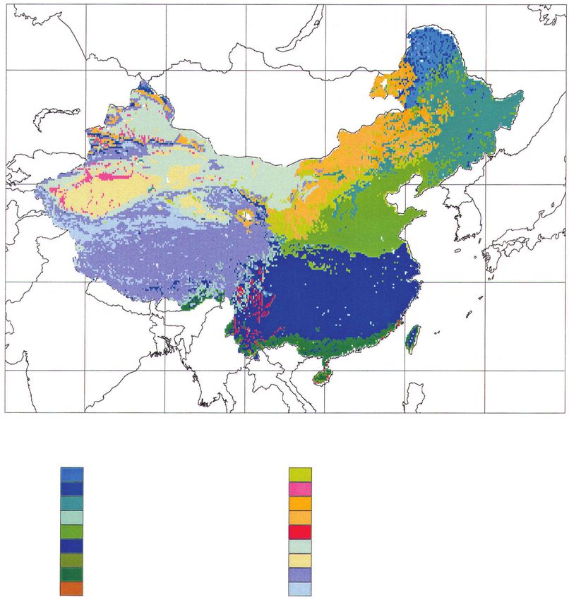
Vegetation Map of China
50
40
30
20
70 80 90 100 110 120 130 140
Vegetation
Boreal Deciduous Forest/Woodland Moist Savannas
Boreal Conifer Forest/Woodland Dry Savannas
Temperate/Boreal Mixed Forest Tall Grassland
Temperate Conifer Forest Short Grassland
Temperate Deciduous Forest Xeric Woodlands/Scrub
Temperate Broadleaved Evergreen Forest Arid Shrubland/Steppe
Tropical Seasonal Forest Desert
Tropical Rain Forest Arctic/Alpine Tundra
Tropical Deciduous Forest Ice/Polar Desert
Fig. 1. Vegetation map of China (HOU et al. 1982) which was used in the BIOME3 model (NI et al. 2000).
103 vegetation types were assigned to 18 biomes (NI et al. 2000).You can also read