Appendix C: Statement of Work ***Update from Modification 9
←
→
Page content transcription
If your browser does not render page correctly, please read the page content below
Good Neighbor Supplemental Project Agreement 1 – Modification 10

                              Agreement No. 15-GN-11091300-1096

      Groundwater and Geological Resource Inventory and Investigations
                                 Phase 2

                        Appendix C: Statement of Work
                       ***Update from Modification 9***
I. Project Description: Conduct groundwater and geological resource inventories and
investigations of identified groundwater/surface water management issues within the
Chequamegon-Nicolet National Forest (CNNF). Prepare reports and maps and make this
information available to the Forest Service and public.

Phase 2 includes two years of work starting in FY2022. A separate statement of work will be
provided for future phases.

II. Forest Service Shall:
    1. Coordinate with WGNHS on project activities to support field work and deliverables.
    2. Provide peer review for draft reports.

III. State Shall:
Complete the proposed project activities for three projects: 1) Drummond area water level
investigation, 2) Investigation of hydrogeology near the Bend deposit in Taylor County, and 3)
Groundwater level monitoring. See below for study tasks and timeline. The projected project end
date for this phase of the work is June 2023.

IV. Goals:
    1. Seepage lakes near Drummond WI, including Pigeon Lake, have historically fluctuated
       widely and currently are at a record high. The goals of this study are to improve our
       understanding of the groundwater-surface water system to manage and protect the water
       resource.
    2. The Bend copper-gold ore deposit, located in Taylor County, is a potentially viable
       deposit for mining in an area with fairly little hydrogeologic data. An improved
       understanding of the local hydrogeology and surface water-groundwater interactions will
       improve the effectiveness of future management and protection of water resources in this
       region. The goals of this project are to collect baseline data and characterize the
       hydrogeology near the Bend ore deposit to contribute to the existing body of knowledge
       of hydrogeology in Northern Wisconsin and to inform management decisions and future
       environmental assessments should a mine be proposed.
    3. Measure, report, and archive groundwater levels in monitoring wells; TA-217 and nested
       piezometers PR-088 and PR-089 (deep bedrock well).
    4. Protect and manage the groundwater/surface water resource and associated ecosystems.

V. Objectives:
    1. For the Drummond area seepage lakes: Characterize the hydrogeologic system around
       Pigeon Lake and evaluate potential future water level conditions. The deliverable for this
       phase is an interim project report.
Estimated Start: In Progress
Estimated Completion: June 2023                                                        Page 1 | 4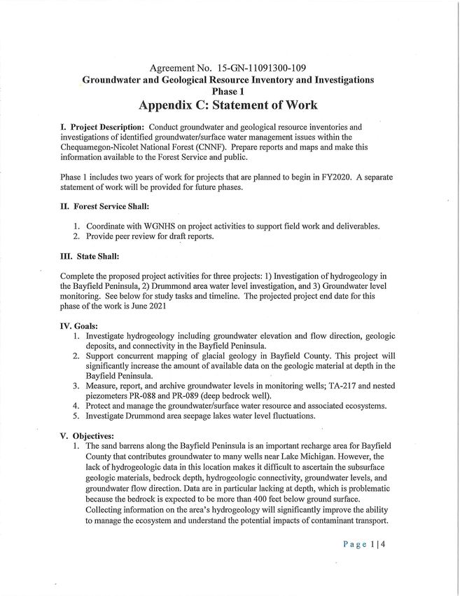
Good Neighbor Supplemental Project Agreement 1 – Modification 10

   2. For the Bend deposit study: 1) Characterize the groundwater and surface water system
      near the Bend deposit to inform the protection of water resources in this area, with a
      focus on characteristics relevant to a potential future mine; 2) collect and publish baseline
      water chemistry, water table, and stream flow data; and 3) contribute to our
      understanding of groundwater-surface water interactions in this part of the state where
      there is little hydrogeologic data. This is planned to be a 3-year project. The project
      deliverables will consist of an interim summary of work (included in this phase) and a
      final report in the following phase (year 3). A stream gage installed as part of this project
      is intended to continue with funding from GNA in future years.
   3. Continue funding for US Geological Survey to measure, report, and archive groundwater
      levels in monitoring wells; TA-217 (Bend well) in the Medford Unit, Taylor County, and
      nested piezometers PR-088 and PR-089 (deep bedrock well) in the Park Falls Unit, Price
      County. The water level data will be published on the statewide monitoring level network
      website.

VI. Tasks and Timeline:
The tasks and general timeline are as follows.

State FY 2021 – FY2022 (April 1, 2021 – June 30, 2022): Total Budget $209,913

   1. Bend hydrogeology (year 1 of 3): Budget $134,696 (includes approximately $25K
      installation and $15.5K annual maintenance and reporting for stream gage)
          a. Install 3-4 water-table monitoring wells in the glacial deposits overlying and near
              the Bend ore body. Monitor water levels and temperature in the wells.
          b. Install long-term streamflow gaging station on the Yellow River at FR112/Yellow
              River Rd (completed by USGS). Real-time precipitation and discharge will be
              recorded on USGS website.
          c. Monitor stream stage and temperature both at gaging station and at second
              location on the river. Collect periodic streamflow measurements at second
              location.
          d. Collect baseline water quality data for both groundwater and surface water.
          e. If Aquila plans more exploratory drillholes, coordinate with them to collect
              geophysical logs, packer tests, and flow logging.
   2. Drummond area water level investigation: Budget $70,228
          a. Continue to monitor groundwater wells and sample water quality
          b. Conduct geophysical surveys to evaluate bedrock depth and subsurface changes in
              key locations
          c. Evaluate lake water balance
          d. Prepare interim project report for USFS
   3. Bayfield Peninsula: Budget $4,989
          a. Continue to monitor groundwater wells and precipitation
          b. Interpret water quality samples and collected data

Estimated Start: In Progress
Estimated Completion: June 2023                                                          Page 2 | 4
Good Neighbor Supplemental Project Agreement 1 – Modification 10

   4. Groundwater level monitoring: Budget included in Task 2
         a. USGS will continue to monitor TA-217 (Bend well) in the Medford Unit, Taylor
            County, and nested piezometers PR-088 and PR-089 (deep bedrock well) in the
            Park Falls Unit, Price County from July 2021 to June 2023.

State FY 2023: Total budget $150,822

   1. Bend hydrogeology (year 2 of 3): Budget $81,147 (includes approximately $15.5K
      annual maintenance and reporting for stream gage)
         a. Continue monitoring
                  i. Water levels and temperature in the groundwater wells.
                 ii. Real-time precipitation and discharge (completed by USGS).
                iii. Stream stage and temperature both at gaging station and at second location
                     on the river. Collect periodic streamflow measurements at second location.
                iv. Baseline water quality data for both groundwater and surface water
                     (quarterly sampling).
         b. Evaluate groundwater interactions with the North Fork Yellow River using mini-
             piezometers, seepage meters, or similar instruments.
         c. If river is accessible, collect spatially-dense stream data via canoe.
         d. Conduct pumping tests in the groundwater wells to investigate hydraulic
             properties.
         e. Provide an interim summary of data and work to USFS. This will consist
             primarily of monitoring data and a summary of the conceptual hydrogeologic
             model of the groundwater and stream system. A final report will be completed in
             the following phase.
   2. Drummond area water level investigation: Budget $69,675
         a. Continue to monitor groundwater wells
         b. Evaluate patterns in precipitation and lake levels with respect to future conditions
             through water balance analysis
         c. Continue to analyze results of data collection
   3. Groundwater level monitoring: Budget included in Task 2
         a. USGS will continue to monitor TA-217 (Bend well) in the Medford Unit, Taylor
             County, and nested piezometers PR-088 and PR-089 (deep bedrock well) in the
             Park Falls Unit, Price County from July 2021 to June 2023.
         b. Add Bayfield Peninsula wells to monitoring network.

For context, the below table inserts the above specific tasks with the tasks expected to be
completed during the full lifetime of the project.

    Time                                        Description                                   Phase
                Bayfield Peninsula hydrogeology field data collection core drilling and
                cross section as part of WGNHS Pleistocene geologic mapping                     1
                inventory for Bayfield County.
  FY 2020       Drummond area seepage lakes investigation of water level fluctuations.
                                                                                                1
  Projects      Install piezometers, collect data.
                Continue annual funding for US Geological Survey to measure, report,
                                                                                                1
                and archive groundwater levels in monitoring wells; TA-217 (Bend
Estimated Start: In Progress
Estimated Completion: June 2023                                                           Page 3 | 4
Good Neighbor Supplemental Project Agreement 1 – Modification 10

              well) in the Medford Unit, Taylor County, and nested piezometers PR-
              088 and PR-089 (deep bedrock well) in the Park Falls Unit, Price
              County. The water quality/level data will be published on the statewide
              monitoring level network website.
              2nd year Bayfield Peninsula hydrogeology data analysis bore hole(s) and
              cross section as part of WGNHS Pleistocene geologic mapping                1
              inventory for Bayfield County.
  FY 2021     2nd year Drummond area seepage lakes investigation water level
                                                                                         1
  Projects    fluctuations.
              Measure, report, archive monitoring wells; TA-217, PR-088 and PR-
                                                                                         1
              089.
              Begin Bend site groundwater baseline study (April 2021).                   2
              Measure, report, archive monitoring wells; Two Bayfield Highlands
                                                                                         2
              wells (names TBD), TA-217, PR-088 and PR-089.
  FY 2022     3rd year Bayfield Peninsula hydrogeology data collection                   2
  Projects    3rd year Drummond area seepage lakes investigation water level
                                                                                         2
              fluctuations.
              1st (full) year Bend Site groundwater baseline study.                      2
              Measure, report, archive monitoring wells; TA-217, PR-088 and PR-
                                                                                         2
              089, and Bayfield Peninsula well(s).
  FY 2023
              4th year Drummond area seepage lakes investigation water level
  Projects                                                                               2
              fluctuations.
              2nd year Bend Site groundwater baseline study.                             2
              Measure, report, archive monitoring wells; TA-217, PR-088 and PR-
              089, and Bayfield Peninsula well(s).
              5th year Drummond area seepage lakes investigation water level
  FY 2024     fluctuations.
  Projects    3rd year Bend site groundwater baseline study
              Begin investigation of surface water/groundwater interactions in the
              Elvoy and Brule creeks watershed located within the Eagle
              River/Florence Ranger District in Vilas and Forest Counties.
              Measure, report, archive monitoring wells; TA-217, PR-088 and PR-
              089, and Bayfield Peninsula well(s).
              Measure, report, archive Yellow River stream gage.
  FY 2025     6th year Drummond area seepage lakes investigation water level
  Projects    fluctuations.
              2 year investigation of surface water/groundwater interactions in the
              Elvoy and Brule creeks watershed located within the Eagle
              River/Florence Ranger District in Vilas and Forest Counties.

IV. Point of Contacts:
       Forest Service: Greg Knight, 715-748-4875, greg.knight3@usda.gov
       Wisconsin DNR: Rebecca Diebel, 608-444-5774, Rebecca.diebel@wisconsin.gov
       Wisconsin Geological and Natural History Survey: Anna Fehling,
       anna.fehling@wisc.edu

Estimated Start: In Progress
Estimated Completion: June 2023                                                    Page 4 | 4
Good Neighbor Supplemental Project Agreement 1 - Modification 9
Agreement No. 15-GN-11091300-109
Groundwater and Geological Resource Inventory and Investigations
Phase 1
APPENDIX C: Statement of Work
***Update from Modification 8***
I. Project Description:
Conduct groundwater and geological resource inventories and investigations of identified
groundwater/surface water management issues within the Chequamegon-Nicolet National Forest
(CNNF). Prepare reports and maps and make this information available to the Forest Service
and public.
Phase 1 includes two years of work for projects that begin in FY2020. A separate statement of
work will be provided for future phases.
II. Forest Service Shall:
1. Coordinate with WGNHS on project activities to support field work and deliverables.
2. Provide peer review for draft reports.
III. State Shall:
Complete the proposed project activities for three projects: 1) Investigation of hydrogeology in
the Bayfield Peninsula, 2) Drummond area water level investigation, and 3) Groundwater level
monitoring. See below for study tasks and timeline. The projected project end date for this
phase of the work is June 2021
IV. Goals:
1. Investigate hydrogeology including groundwater elevation and flow direction, geologic
deposits, and connectivity in the Bayfield Peninsula.
2. Support concurrent mapping of glacial geology in Bayfield County. This project will
significantly increase the amount of available data on the geologic material at depth in the
Bayfield Peninsula.
3. Measure, report, and archive groundwater levels in monitoring wells; TA-217 and nested
piezometers PR-088 and PR-089 (deep bedrock well).
4. Protect and manage the groundwater/surface water resource and associated ecosystems.
5. Investigate Drummond area seepage lakes water level fluctuations.
V. Objectives:
1. The sand barrens along the Bayfield Peninsula is an important recharge area for Bayfield
County that contributes groundwater to many wells near Lake Michigan. However, the
lack of hydrogeologic data in this location makes it difficult to ascertain the subsurface
geologic materials, bedrock depth, hydrogeologic connectivity, groundwater levels, and
groundwater flow direction. Data are in particular lacking at depth, which is problematic
C-1
Estimated Start: In Progress
Estimated Completion: June 2021Good Neighbor Supplemental Project Agreement 1 - Modification 9
because the bedrock is expected to be more than 400 feet below ground surface.
Collecting information on the area’s hydrogeology will significantly improve the ability
to manage the ecosystem and understand the potential impacts of contaminant transport.
2. Continue funding for US Geological Survey to measure, report, and archive groundwater
levels in monitoring wells; TA-217 (Bend well) in the Medford Unit, Taylor County, and
nested piezometers PR-088 and PR-089 (deep bedrock well) in the Park Falls Unit, Price
County. The water quality/level data will be published on the statewide monitoring level
network website.
3. Drummond area seepage lakes investigation of the wide fluctuation in lake levels from
apparent wide fluctuation in groundwater levels in response to extreme precipitation
events. Record high water levels in Pigeon lake and area lakes caused historic flooding
and damage to road infrastructure and private residences.
VI. Tasks and Timeline:
The tasks and general timeline are as follows.
State FY 2020 (Begin July 2019): Total Budget $191,000
1. Bayfield Peninsula Hydrogeology (year 1 of 2): Budget $149,000
a. Drill up to two rotosonic cores in the Bayfield Peninsula to approximately 200
feet depth. A single, deeper core may be drilled if the water level is deeper than
anticipated.
b. Complete geophysical logging in both of these locations.
c. Install nested monitoring wells in both of these locations and monitor water
levels.
d. Sample groundwater for isotopes and water quality.
e. Log and interpret the core.
f. Complete grain size analysis.
2. Drummond area water level investigation: Budget $40,000 (includes Task 3)
a. Install Drummond area lakes piezometers
b. Monitor piezometers
3. Groundwater level monitoring: Budget $2,000 (included in Task 2, total)
a. USGS will continue to monitor TA-217 (Bend well) in the Medford Unit, Taylor
County, and nested piezometers PR-088 and PR-089 (deep bedrock well) in the
Park Falls Unit, Price County from January to June 2020 (already funded through
December 2019).
State FY 2021: Total budget $131,000 (updated to account for anticipated extra costs for
drilling and well installation, as well as installing an air line at Horseshoe Lake well)
1. Bayfield Peninsula Hydrogeology (year 2 of 2): Budget $108,000
a. Use data from rotosonic cores to inform 1:100,000 scale Pleistocene mapping. A
map and accompanying report will be completed and published as part of a
separate project.
b. Install air line at Horseshoe Lake well.
C-2
Estimated Start: In Progress
Estimated Completion: June 2021Good Neighbor Supplemental Project Agreement 1 - Modification 9
c. Evaluate hydrogeology in the vicinity of the two wells, such as horizontal and
vertical gradient, baseline water chemistry, findings from geophysical logging,
and type and consistency of glacial deposits.
d. Publish a technical report of findings. Draft reports will be provided to USFS for
peer review.
2. Drummond area water level investigation: Budget $19,000 (Includes Task 3)
a. Continue monitoring water levels in Drummond area
3. Groundwater level monitoring: Budget $4,000 (included in Task 2 total)
a. USGS to monitor TA-217 and nested piezometers PR-088 and PR-089 for fiscal
year.
For context, the below table inserts the above specific tasks with the tasks expected to be
completed during the full lifetime of the project.
Time Description Phase
Bayfield Peninsula hydrogeology field data collection core drilling and
cross section as part of WGNHS Pleistocene geologic mapping 1
inventory for Bayfield County.
Drummond area seepage lakes investigation of water level fluctuations.
1
Install piezometers, collect data.
FY 2020 Continue annual funding for US Geological Survey to measure, report,
Projects and archive groundwater levels in monitoring wells; TA-217 (Bend
well) in the Medford Unit, Taylor County, and nested piezometers PR-
1
088 and PR-089 (deep bedrock well) in the Park Falls Unit, Price
County. The water quality/level data will be published on the statewide
monitoring level network website.
2nd year Bayfield Peninsula hydrogeology data analysis bore hole(s) and
cross section as part of WGNHS Pleistocene geologic mapping 1
inventory for Bayfield County.
2nd year Drummond area seepage lakes investigation water level
FY 2021 1
fluctuations.
Projects
Measure, report, archive monitoring wells; TA-217, PR-088 and PR-
1
089.
Measure, report, archive monitoring wells; TA-217, PR-088 and PR-
089.
FY 2022
3rd year Drummond area seepage lakes investigation water level
Projects
fluctuations.
Bend Site groundwater baseline study.
Measure, report, archive monitoring wells; TA-217, PR-088 and PR-
089.
FY 2023
4th year Drummond area seepage lakes investigation water level
Projects
fluctuations.
2nd year Bend Site groundwater baseline study.
Measure, report, archive monitoring wells; TA-217, PR-088 and PR-
089.
FY 2024
5th year Drummond area seepage lakes investigation water level
Projects
fluctuations.
3rd year Bend Site groundwater baseline study.
C-3
Estimated Start: In Progress
Estimated Completion: June 2021Good Neighbor Supplemental Project Agreement 1 - Modification 9
Begin investigation of surface water/groundwater interactions in the
Elvoy and Brule creeks watershed located within the Eagle
River/Florence Ranger District in Vilas and Forest Counties.
Measure, report, archive monitoring wells; TA-217, PR-088 and PR-
089.
FY 2025
Investigate surface water/groundwater interactions in the Elvoy and
Projects
Brule creeks watershed located within the Eagle River/Florence Ranger
District in Vilas and Forest Counties.
IV. Point of Contacts:
x Forest Service: Greg Knight, 715-748-4875, greg.knight3@usda.gov
x Wisconsin DNR: Rebecca Diebel, 608-444-5774, Rebecca.diebel@wisconsin.gov
x Wisconsin Geological and Natural History Survey: Anna Fehling,
anna.fehling@wisc.edu
C-4
Estimated Start: In Progress
Estimated Completion: June 2021Good Neighbor Supplemental Project Agreement 1 - Modification 8
Agreement No. 15-GN-11091300-109
Groundwater and Geological Resource Inventory and Investigations
Phase 1
Appendix C: Statement of Work
I. Project Description: Conduct groundwater and geological resource inventories and
investigations of identified groundwater/surface water management issues within the
Chequamegon-Nicolet National Forest (CNNF). Prepare reports and maps and make this
information available to the Forest Service and public.
Phase 1 includes two years of work for projects that are planned to begin in FY2020. A separate
statement of work will be provided for future phases.
II. Forest Service Shall:
1. Coordinate with WGNHS on project activities to supp01t field work and deliverables.
2. Provide peer review for draft reports.
III. State Shall:
Complete the proposed project activities for three projects: 1) Investigation of hydrogeology in
the Bayfield Peninsula, 2) Drummond area water level investigation, and 3) Groundwater level
monitoring. See below for study tasks and timeline. The projected project end date for this
phase of the work is June 2021
IV. Goals:
1. Investigate hydrogeology including groundwater elevation and flow direction, geologic
deposits, and connectivity in the Bayfield Peninsula.
2. Supp01t concurrent mapping of glacial geology in Bayfield County. This project will
significantly increase the amount of available data on the geologic material at depth in the
Bayfield Peninsula.
3. Measure, report, and archive groundwater levels in monitoring wells; TA-217 and nested
piezometers PR-088 and PR-089 (deep bedrock well).
4. Protect and manage the groundwater/surface water resource and associated ecosystems.
5. Investigate Drummond area seepage lakes water level fluctuations.
V. Objectives:
1. The sand barrens along the Bayfield Peninsula is an important recharge area for Bayfield
County that contributes groundwater to many wells near Lake Michigan. However, the
lack of hydro geologic data in this location makes it difficult to ascertain the subsurface
geologic materials, bedrock depth, hydrogeologic connectivity, groundwater levels, and
groundwater flow direction. Data are in pmticular lacking at depth, which is problematic
because the bedrock is expected to be more than 400 feet below ground surface.
Collecting information on the area's hydrogeology will significantly improve the ability
to manage the ecosystem and understand the potential impacts of contaminant transp01t.
P ag e 114
Estimated Start: July 2019
Estimated Completion: June 2021Good Neighbor Supplemental Project Agreement 1 - Modification 8
2. Continue funding for US Geological Survey to measure, report, and archive groundwater
levels in monitoring wells; TA-217 (Bend well) in the Medford Unit, Taylor County, and
nested piezometers PR-088 and PR-089 (deep bedrock well) in the Park Falls Unit, Price
County. The water quality/level data will be published on the statewide monitoring level
network website.
3. Drummond area seepage lakes investigation of the wide fluctuation in lake levels from
apparent wide fluctuation in groundwater levels in response to extreme precipitation
events. Record high water levels in Pigeon lake and area lakes caused historic flooding
and damage to road infrastructure and private residences.
VI. Tasks and Timeline:
The tasks and general timeline are as follows.
State FY 2020 (Begin July 2019): Total Budget $187,288
1. Bayfield Peninsula Hydrogeology (year 1 of 2): Budget $148,776
a. Drill up to two rotosonic cores in the Bayfield Peninsula to approximately 200
feet depth. A single, deeper core may be drilled if the water level is deeper than
anticipated.
b. Complete geophysical logging in both of these locations.
c. Install nested monitoring wells in both of these locations and monitor water
levels.
d. Sample groundwater for isotopes and water quality.
e. Log and interpret the core.
f. Complete grain size analysis.
2. Drummond area water level investigation: Budget $38,512 (includes Task 3)
a. Install Drummond area lakes piezometers
b. Monitor piezometers
3. Groundwater level monitoring: Budget $1,550 (included in Task 2, total)
a. USGS will continue to monitor TA-217 (Bend well) in the Medford Unit, Taylor
County, and nested piezometers PR-088 and PR-089 (deep bedrock well) in the
Park Falls Unit, Price County from January to June 2020 (already funded through
December 2019).
State FY 2021: Total budget $91,955
1. Bayfield Peninsula Hydrogeology (year 2 of 2): Budget $74,053
a. Use data from rotosonic cores to inform 1: 100,000 scale Pleistocene mapping. A
map and accompanying report will be completed and published as pait of a
separate project.
b. Evaluate hydrogeology in the vicinity of the two wells, such as horizontal and
vertical gradient, baseline water chemistry, findings from geophysical logging,
and type and consistency of glacial deposits.
c. Publish a technical report of findings. Draft repmts will be provided to USFS for
peer review.
Pag e 214
Estimated Start: July 2019
Estimated Completion: June 2021Good Neighbor Supplemental Project Agreement 1 - Modification 8
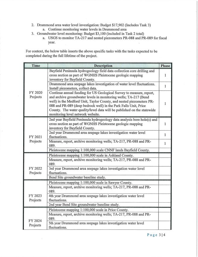
2. Drummond area water level investigation: Budget $17,902 (Includes Task 3)
a. Continue monitoring water levels in Drummond area
3. Groundwater level monitoring: Budget $3,100 (included in Task 2 total)
a. USGS to monitor TA-217 and nested piezometers PR-088 and PR-089 for fiscal
year.
For context, the below table inserts the above specific tasks with the tasks expected to be
completed during the full lifetime of the project.
Time Description Phase
Bayfield Peninsula hydro geology field data collection core drilling and
cross section as part of WGNHS Pleistocene geologic mapping 1
inventory for Bayfield County.
Drummond area seepage lakes investigation of water level fluctuations.
1
Install piezometers, collect data.
FY 2020 Continue annual funding for US Geological Survey to measure, report,
Projects and archive groundwater levels in monitoring wells; TA-217 (Bend
well) in the Medford Unit, Taylor County, and nested piezometers PR-
1
088 and PR-089 (deep bedrock well) in the Park Falls Unit, Price
County. The water quality/level data will be published on the statewide
monitoring level network website.
2nd year Bayfield Peninsula hydrogeology data analysis bore hole(s) and
cross section as part of WGNHS Pleistocene geologic mapping 1
inventory for Bayfield County.
2nd year Drummond area seepage lakes investigation water level
1
FY 2021 fluctuations.
Projects Measure, report, archive monitoring wells; TA-217, PR-088 and PR-
1
089.
Pleistocene mapping 1:100,000 scale CNNF lands Bayfield County.
Pleistocene mapping 1: 100,000 scale in Ashland County.
Measure, report, archive monitoring wells; TA-217, PR-088 and PR-
089.
FY2022 3rd year Drummond area seepage lakes investigation water level
Projects fluctuations.
Bend Site groundwater baseline study.
Pleistocene mapping 1: 100,000 scale in Sawyer County.
Measure, report, archive monitoring wells; TA-217, PR-088 and PR-
089.
FY2023 4th year Drummond area seepage lakes investigation water level
Projects fluctuations.
2nd year Bend Site groundwater baseline study.
Pleistocene mapping 1: 100,000 scale in Price County.
Measure, report, archive monitoring wells; TA-217, PR-088 and PR-
089.
FY2024
5th year Drummond area seepage lakes investigation water level
Projects
fluctuations.
Page 314
Estimated Start: July 2019
Estimated Completion: June 2021Good Neighbor Supplemental Project Agreement 1 - Modification 8
3rd year Bend Site groundwater baseline study.
Begin investigation of surface water/groundwater interactions in the
Elvoy and Brule creeks watershed located within the Eagle
River/Florence Ranger District in Vilas and Forest Counties.
Pleistocene mapping I: I 00,000 scale in Price County.
Measure, repo1t, archive monitoring wells; TA-217, PR-088 and PR-
089.
FY2025
2 year investigation of surface water/groundwater interactions in the
Projects
Elvoy and Brule creeks watershed located within the Eagle
River/Florence Ranger District in Vilas and Forest Counties.
IV. Point of Contacts:
• Forest Service: Greg Knight, 715-748-4875, greg.knight3@usda.gov
• Wisconsin DNR: Rebecca Diebel, 608-444-5774, Rebecca.diebel@wisconsin.gov
• Wisconsin Geological and Natural History Survey: Anna Fehling,
anna.fehling@wisc.edu
Page 4J4
Estimated Start: July 2019
Estimated Completion: June 2021You can also read