Beyond Newgrange: Brú na B oinne in the later Neolithic
←
→
Page content transcription
If your browser does not render page correctly, please read the page content below
Proceedings of the Prehistoric Society 2021, page 1 of 30 © The Author(s), 2021. Published by Cambridge
          University Press on behalf of The Prehistoric Society. This is an Open Access article, distributed under the terms
          of the Creative Commons Attribution licence (http://creativecommons.org/licenses/by/4.0/), which permits
          unrestricted re-use, distribution, and reproduction in any medium, provided the original work is properly cited.
          doi:10.1017/ppr.2021.6

              Beyond Newgrange: Brú na Bóinne in the later Neolithic

                                                               By STEPHEN DAVIS1 and             KNUT RASSMANN2

          The Brú na Bóinne World Heritage Site, Ireland is best known for its megalithic monuments, in particular the great
          developed passage tombs of Knowth, Dowth, and Newgrange, and its abundance of megalithic art. However, our
          understanding of the wider Brú na Bóinne landscape has changed beyond all recognition in the last decade owing to
          the application of modern, non-invasive survey technologies – in particular LiDAR and large-scale geophysical survey
          – and most recently as a result of the hot, dry summer of 2018 which revealed a series of remarkable cropmarks
          between Newgrange and the River Boyne. Despite a lack of excavation it can be argued, based on their morphological
          characteristics, that many of the structures revealed belong within the corpus of late Neolithic ritual/ceremonial struc-
          tures, including earthen henges, square-in-circle monuments, palisaded enclosures, and pit/post-alignments. These
          display both extraordinary diversity, yet also commonality of design and architecture, both as a group and with
          the passage tombs that preceded them. This paper provides an up-to-date survey of the late Neolithic and presumed
          late Neolithic landscape of Brú na Bóinne. It provides new evidence and new insights from ongoing survey campaigns,
          suggesting parallels within the British Neolithic but also insular development within some monument classes.
          Keywords: Brú na Bóinne, Newgrange, Knowth, geophysical survey, LiDAR, Neolithic landscape

          The unusually dry summer of 2018 brought exceptional                                 hampered by the lack of excavation of Irish henge monu-
          conditions for aerial archaeology across Britain and                                 ments in recent decades (cf. Smyth 2009, 91). Much of
          Ireland. Arguably, some of the most striking discoveries                             the information presented here can therefore only be
          of this drought came from Ireland and, in particular,                                based upon analogies with excavated sites in Ireland
          from the Brú na Bóinne World Heritage site, revealing                               and elsewhere and interpretations are likely to be subject
          a series of cropmark enclosures including some of                                    to change with any future excavation and dating of
          unusual design (Condit & Keegan 2018). In parallel                                   archaeological features.
          to these remarkable aerial discoveries, many other previ-
          ously unidentified archaeological features have been
          revealed by an ongoing programme of large-scale geo-                                     THE ARCHAEOLOGICAL ENSEMBLE OF THE BEND
          magnetic survey, covering c. 350 ha of the World                                               IN THE BOYNE (BRÚ NA BÓINNE)
          Heritage Site core area and buffer zones since 2014.                                 Brú na Bóinne is one of only two UNESCO World
          These discoveries provided the initial impetus for this                              Heritage Sites in the Republic of Ireland and one of
          review, the main objective of which is to provide an                                 the most significant prehistoric archaeological land-
          up-to-date survey of the late Neolithic monumentality                                scapes in Europe. The ‘Bend in the Boyne’ occupies a
          of Brú na Bóinne and to place some of these recent dis-                             broad, rock-cut meander in the river, bounded to the
          coveries in a regional context. It must be stressed at the                           north by a second, smaller river, the Mattock (Lewis
          outset that any synthesis of these sites is severely                                 et al. 2017). The area is best known for its Neolithic
                                                                                               passage tombs, especially the large developed tombs
          1
                                                                                               of Knowth, Dowth, and Newgrange, which were con-
           UCD School of Archaeology, Belfield, Dublin 4. stephen.                             structed towards the end of the 4th millennium BC (see
          davis@ucd.ie
          2
           Römisch-Germanische Kommission, Palmengartenstraße                                  dates summarised in Smyth 2009; Eogan & Cleary
          10-12. 60325 Frankfurt a. M. knut.rassmann@dainst.de                                 2017), and for the remarkable corpus of megalithic

                                                                                           1

Downloaded from https://www.cambridge.org/core. IP address: 46.4.80.155, on 03 Nov 2021 at 20:35:39, subject to the Cambridge Core terms of use, available at
https://www.cambridge.org/core/terms. https://doi.org/10.1017/ppr.2021.6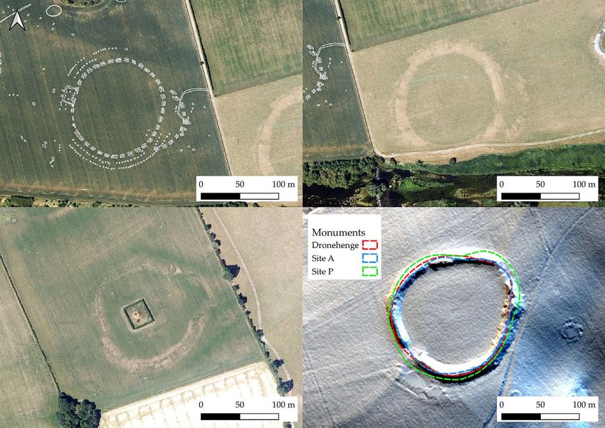
THE PREHISTORIC SOCIETY

                  art within the necropolis (c. 400 decorated stones at                                so they are primarily referred to using the unique
                  Knowth alone; O’Sullivan 2006).                                                      Irish Sites and Monuments Record (SMR) number.1
                     In addition to the middle Neolithic tombs, for                                    Most of the potential archaeological sites identified
                  which it is justifiably famous (Herity 1975; Eogan                                   by the ongoing campaign of geomagnetic survey have
                  1986; Eogan & Doyle 2010), Brú na Bóinne preserves                                  not yet been included in the SMR database and have
                  a remarkable collection of probable late Neolithic                                   each been assigned a unique identifier within the sur-
                  monuments that are especially concentrated in the                                    vey GIS, comprising a two or three-letter townland
                  area between Newgrange and the River Boyne.                                          abbreviation and a site number. These are summarised
                  These comprise an increasingly diverse group of                                      in Table 1 and Figure 1, which also identifies the
                  earthen and timber monuments, most likely dating                                     means by which more recently discovered sites have
                  to the early–middle 3rd millennium BC. They include                                  been identified. Additionally, within Brú na Boinne
                  ‘embanked enclosures’ (see Stout 1991) or henge                                      there remain issues of classification regarding some
                  monuments (see below), circular/sub-circular enclo-                                  site types. Some sites that are almost certainly passage
                  sures incorporating a central four-post setting                                      tombs and have been discussed as such within the
                  (‘square-in-circle’ monuments or ‘four-post structures’ –                            literature (eg, the Ballinacrad tombs; Cooney 2000,
                  eg, Bradley 2007, 119; Noble et al. 2012; Carlin &                                   154) are recorded within the SMR and RMP as
                  Cooney 2017), and timber structures, including                                       mound barrows and/or mounds. Similarly, the classi-
                  palisades and post alignments. This monumental com-                                  fications ‘henge’ and ‘embanked enclosure’ are
                  plex has seen relatively little ground-based research                                used interchangeably and seemingly arbitrarily. For
                  and has largely been discovered in recent years through                              the purposes of this paper, henges and embanked
                  aerial photography, satellite imagery, analysis of                                   enclosures are regarded as indistinguishable. Passage
                  LiDAR data, and large-scale geomagnetic surveys                                      tombs, mound barrows, and mounds within Brú na
                  (Davis et al. 2013; Megarry & Davis 2013 Condit &                                    Bóinne are more problematic and have tended to be
                  Keegan 2018; Davis 2018; Leigh et al. 2018;                                          treated as ‘known unknowns’ – sites that are widely
                  Rassmann et al. 2019; see Fig. 1 & Table 1). Along                                   known and accepted as passage tombs (eg, Herity
                  with chance discoveries of late Neolithic material                                   1975) but are not classified as such within the Irish
                  during excavations in the vicinity of Knowth and                                     RMP or SMR.
                  Newgrange these sites, many of which have little or
                  no surface expression, are crucial to our understanding
                  of Brú na Bóinne in the period following passage tomb                                             EXCAVATION AND CHRONOLOGY
                  construction.                                                                        As already stated, there has been little excavation of
                                                                                                       henge monuments or timber circles within Brú na
                                                                                                       Bóinne in recent decades and no earthen henge monu-
                  A note on site names in Brú na Bóinne                                               ment has been excavated here since the partial
                  Historically, sites within Brú na Bóinne were assigned                              excavations at Monknewtown (Sweetman 1971;
                  single letter identifiers, first by Coffey (1912) with sub-                          1976). Both O’Kelly et al. (1983) and Sweetman
                  sequent revision by Claire O’Kelly (1978); while                                     et al. (1985) excavated elements of the Newgrange
                  initially useful, this led to an inevitable shortage once                            Pit Circle, with further excavations undertaken at
                  the end of the alphabet was reached with Tomb Z                                      the possible Western Circle (Sweetman et al. 1987)
                  (O’Kelly et al. 1978). This has in turn led to a more                                and the Knowth four-post structure (Eogan &
                  ad hoc naming of sites in recent years, such as the sites                            Roche 1997; 1999). In this context, the test excavation
                  regrettably identified by one of the authors as Sites                                of part of the ‘Great Rectangular Palisade’ in 2018
                  LP1 and LP2 (LP = Low Profile; Davis et al. 2013)                                    (Leigh et al. 2018; 2019) represents the most
                  and the more recent descriptive names assigned by                                    significant recent excavation within the Brú na
                  Condit and Keegan (2018) such as ‘The Great                                          Bóinne late Neolithic complex. While the dates from
                  Palisade’, ‘The Geometric Henge’ and the ‘Great                                      the Knowth four-post structure, possible Western
                  Rectangular Palisade Enclosure’. Clearly the naming                                  Circle, and Newgrange Pit Circle cluster in the
                  of these sites is long overdue for revision. In the cur-                             early–middle 3rd millennium BC, those from the
                  rent paper O’Kelly’s (1978) identifiers are used where                               Monknewtown Henge remain highly problematic,
                  possible; however, ‘new’ sites are lacking these and                                 ranging from the middle Neolithic through to the early

                                                                                                   2

Downloaded from https://www.cambridge.org/core. IP address: 46.4.80.155, on 03 Nov 2021 at 20:35:39, subject to the Cambridge Core terms of use, available at
https://www.cambridge.org/core/terms. https://doi.org/10.1017/ppr.2021.6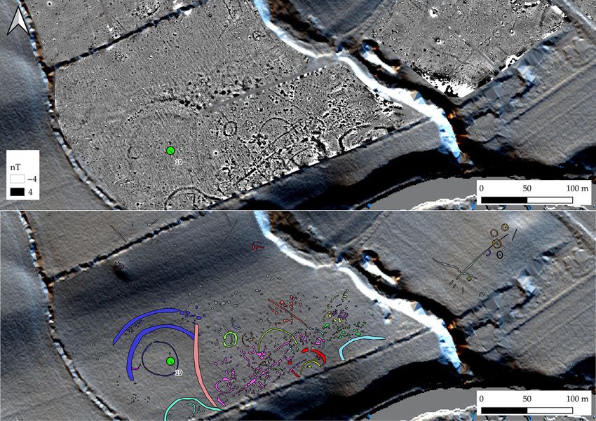
S. Davis & K. Rassmann.                 BEYOND NEWGRANGE: BRÚ NA BÓINNE IN THE LATER NEOLITHIC

                                                                   Fig. 1.
             LiDAR-based 32-direction hillshade showing potential late Neolithic sites. Passage tomb and probable passage tomb
            locations also marked. Elevation data over 32-direction hillshade. For key see Table 1 (LiDAR data courtesy of Meath
                                                               County Council)

          medieval period. These dates are summarised in Smyth                                    In her comprehensive (for the time) review of the
          (2009, appendix iv).                                                                 Boyne embanked enclosures, Stout (1991) suggested
                                                                                               that these monuments did not have internal ditches
                                                                                               as in classic British henge monuments but were,
                    THE ‘EMBANKED ENCLOSURES’ OR HENGES                                        instead, formed by scarping out an area internal to
                              OF BRÚ NA BÓINNE                                                 the line of the bank in order to create material for
          The class of monuments known in Ireland as                                           bank construction. This ditchless form has become
          ‘embanked enclosures’ are generally considered to                                    widely accepted as normal for Ireland (eg, Harding
          be analogous to British henge monuments (Stout                                       2003, 19) and has led to comparison with British sites
          1991; Condit & Simpson 1998; O’Sullivan et al.                                       lacking a ditch such as Mayburgh, Cumbria (Topping
          2012). In form these mostly comprise large                                           1992). While this does appear to be the case in
          (140–200 m), saucer-shaped earthen enclosures,                                       some Irish sites (eg, Ballynahatty, Co. Down and
          most of which are greatly denuded with surviving                                     Fourknocks, Co. Meath), geophysical survey (eg,
          banks significantly less than 1 m in height. They are                                Davis 2013; Davis et al. 2013, and unpublished data),
          predominantly located on the lower terraces of the                                   aerial photography (Condit & Keegan 2018), and
          Boyne and incorporate a gentle to moderate slope,                                    limited excavation (eg, Danaher 2005; 2007;
          often facing towards water (cf. Richards 1996).                                      Ó Donnchadha & Grogan 2010) have, in recent years,

                                                                                           3

Downloaded from https://www.cambridge.org/core. IP address: 46.4.80.155, on 03 Nov 2021 at 20:35:39, subject to the Cambridge Core terms of use, available at
https://www.cambridge.org/core/terms. https://doi.org/10.1017/ppr.2021.6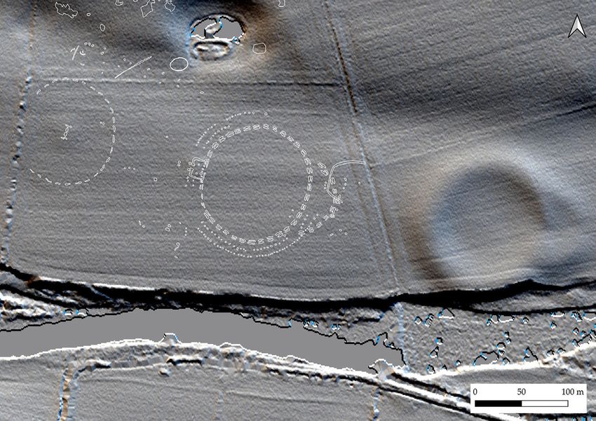
https://www.cambridge.org/core/terms. https://doi.org/10.1017/ppr.2021.6
Downloaded from https://www.cambridge.org/core. IP address: 46.4.80.155, on 03 Nov 2021 at 20:35:39, subject to the Cambridge Core terms of use, available at
TABLE 1: SITES MARKED IN FIG. 1
Site no. Usual name Site type Alternative name Means of discovery Easting (ING) Northing (ING) Elevation m OD
1 Site P H ME026-006 AP 300777 271961 11.63
2 NG16 4P G 300404 272689 42.81
3 NG10 4P G 300185 272799 42.97
4 Small enclosure1 H AP 301517 272254 6.52
5 Site A12 H ALS 301071 272415 22.95
6 Dowth Henge H Site Q; ME020-010 Historic 303423 274176 57.98
7 ME019-129 PA Great Rectangular Palisade1 G 300666 272446 27.53
8 ME020-083 H G 303144 274120 65.94
9 DOW19 OT Dowth rectangular structure G 303111 274019 69.11
10 Site A H ME019-049002 Historic 301121 272312 21.47
11 Knowth four-post structure 4P ME019-030033 E 299738 273429 66.54
12 Monknewtown Pond H ME019-015 Historic 300433 275204 29.51
13 Monknewtown Henge H ME019-016001 Historic 300726 275526 32.79
THE PREHISTORIC SOCIETY
14 Newgrange pit circle OT ME019-044002 E 300845 272715 48.05
15 ME026-033 H Dronehenge; Geometric Henge1 AP 300522 272006 14.1
16 ME019-094 H Site LP22; Univallate Henge1 ALS 300312 272054 15.46
17 ME019-058002 H Site B1 enclosure ALS 301458 272124 6.69
18 ME019-067002 4P AP 274176 274176 24.81
4
19 ME019-103 H Site LP12 ALS 272446 272446 20.4
20 Riverside Henge1 H AP 274120 274120 7.11
21 Great Palisade1 OT AP 274019 274019 23.3
22 Hidden Henge1 H AP 300397 271974 13.36
23 NG39 4P G 300108 272563 30.53
24 DOW61 4P G 301489 273039 35.41
25 OLD12 PA G 304372 273854 92.02
26 DOW16 PA G 303147 274027 68.24
27 NG51 OT G 300127 272153 18.23
28 DOW62 OT G 301545 273032 34.23
29 ME019-046005 4P Newgrange Western Circle E 300673 272704 54.3
30 Newgrange cursus OT ME019-044001 Historic 300912 272776 46.48
31 Pit circle avenue PA G 300892 272690 47.57
Means of discovery: AP = aerial photography; G = geophysics; E = excavation; ALS = airborne laser scanning (LiDAR). Other sites were recorded
historically.
Site type: H = henge; 4P = four-post structure; PA = post alignment; OT = other.
1
Site name after Condit & Keegan (2018).
2
Site name after Davis et al. (2013).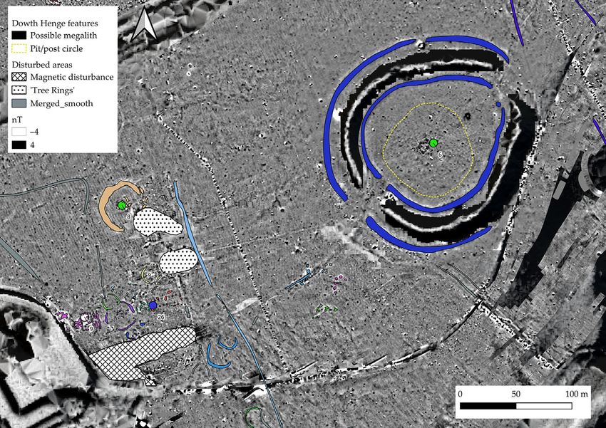
S. Davis & K. Rassmann.                 BEYOND NEWGRANGE: BRÚ NA BÓINNE IN THE LATER NEOLITHIC

          shown the situation to be much more complex with a                                   O’Sullivan et al. 2012; Davis et al. 2013). Site A
          number of sites now shown to have at least internal                                  encloses a substantial mound, most likely a passage
          and, in some cases, external ditches.                                                tomb, but interpretation of the site is hampered by sig-
             Most Irish sites appear to possess only a single                                  nificant damage that occurred in the 1960s (O’Kelly
          opening; however, both Dowth Henge and                                               et al. 1978, 50). While Dowth Henge is also flattened
          Newgrange Site P have indications of dual opposing                                   to one side (the south-west) it is substantively different
          entrances. The lack of any obvious opening in many                                   from the other recorded Boyne sites, both in terms of
          of these sites is problematic but may indicate that                                  its landscape position and gross morphology: it is sit-
          the original entrance was relatively unelaborated, per-                              uated in an elevated position above the Boyne and has
          haps just a narrow break in the bank as appears to be                                substantial, well-preserved banks, dual opposing
          the case in the west of Newgrange Site P. Similarly, at                              entrances and clear evidence of internal scarping.
          Tonafortes, Co. Sligo, Danaher (2007, 46) describes                                  Arguably, however, the eccentric ovoid form seen at
          the entrance as comprising ‘an 8.2m-wide undug                                       Dowth Henge is equivalent to the primary phase of
          causeway : : : [with] no other associated features’. It                              Sites A and P (and of site ME026-033 – see below),
          is also possible that the lack of obvious entrance fea-                              representing the outline of the enclosure plus
          tures is indicative of deliberate ‘blocking’ of entrances                            annex (Fig. 2).
          as sites fell from use (cf. Brophy & Noble 2012). The                                   LiDAR analysis in 2010 identified a further four
          status of these monuments in Ireland is far from clear,                              possible henge monuments (Table 1; Fig 1: Sites 8,
          with a wide-ranging review by Condit and Simpson                                     9, 13 & 19) between Newgrange and the River
          (1998) identifying a very broad spectrum of potential                                Boyne (O’Sullivan et al. 2012; Davis et al. 2013), some
          ‘hengiform’ sites; to some extent this emphasises the                                of which have subsequently been confirmed by aerial
          point eloquently made by Alex Gibson (2012): that                                    photography (Condit & Keegan 2018). The same pro-
          archaeologists can no longer clearly define what a                                   gramme of research also identified a fifth site of this
          henge actually is.                                                                   type at Carranstown, Co. Meath, a further 6 km
                                                                                               south-east of Newgrange, midway between the cluster
                                                                                               of sites in Brú na Bóinne and a second group of at least
            ARCHAEOLOGICAL PROSPECTION IN BRÚ NA BÓINNE:                                       three henge monuments associated with the passage
                     LIDAR AND AERIAL SURVEY                                                   tomb cemetery at Fourknocks, Co. Meath (Stout
          Prior to 2010 there were four recorded embanked                                      1991; O’Sullivan et al. 2012).
          enclosures/henge monuments in the wider Brú na                                          Aerial photography has contributed significantly to
          Bóinne landscape: the Monknewtown Henge, par-                                       our understanding of the construction of these monu-
          tially excavated by Sweetman (1971; 1976) and                                        ments, especially in the context of Collins’s (1957)
          subsequently largely destroyed; Sites A and P between                                excavations at the Giant’s Ring, Ballynahatty, Co.
          Newgrange and the Boyne; and Dowth Henge (more                                       Down. Collins proposed a three-phase bank construc-
          rarely referred to as Site Q) to the east. The anomalous                             tion: an outer gravel ‘guide’ enclosure (most likely an
          ‘ritual pond’ at Monknewtown is also a developed                                     early construction phase), insubstantial but defining
          monument of this class, comprising a high enclosing                                  the periphery of the bank; the main body of the bank
          bank surrounding a sunken, water-retaining central                                   made from earth and stone; and a boulder revetment
          area. A radiocarbon date of 2847–2469 cal BC was                                     placed on the inner shoulder of the monument (Fig. 3).
          obtained from a core through the waterlogged exter-                                  Elements of this phased construction are apparent in
          nal ditch fill (Beta-288747; 4050±40 BP: Davis et al.                                aerial images of Site P taken over several decades.
          2010; recalibrated using IntCal20: Reimer et al.                                     While the main body of the bank is visible as a sub-
          2020). Sites A and P are similar in gross morphology,                                stantial parchmark, an outer parchmark enclosure
          both being shallow and dish-shaped with no topo-                                     can also be seen in dry years (eg, 2018; Fig. 3). At
          graphic evidence of either an inner or outer ditch or                                Site P, the eastern annex, rather than being continuous
          of internal scarping. They are flattened to their west-                              with the main bank, is instead an extension of
          ern side, possess broad, low banks, and each also                                    the outer enclosure. The irregular nature of the
          includes an unusual annex to the eastern side, creating                              parchmark, especially in the annex, may suggest a seg-
          an additional defined space between the main                                         mented construction technique, also argued by Condit
          enclosure and an apparent entrance (Stout 1991;                                      and Keegan (2018, 85–9) for Site A. Aerial imagery

                                                                                           5

Downloaded from https://www.cambridge.org/core. IP address: 46.4.80.155, on 03 Nov 2021 at 20:35:39, subject to the Cambridge Core terms of use, available at
https://www.cambridge.org/core/terms. https://doi.org/10.1017/ppr.2021.6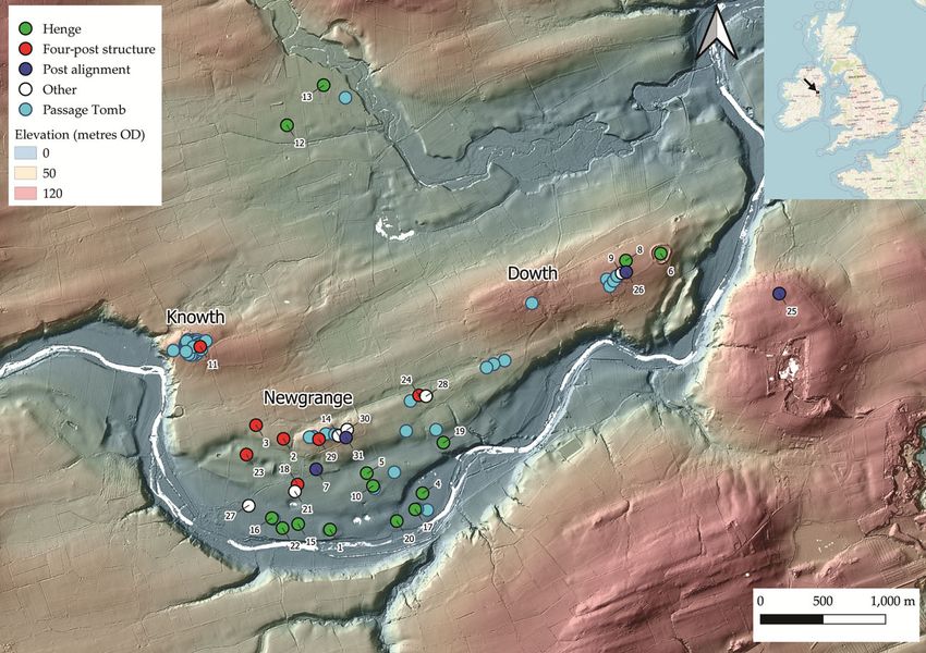
THE PREHISTORIC SOCIETY

                                                                            Fig. 2.
                  Henges/embanked enclosures in Brú na Bóinne: top left: ME026-033 (‘Dronehenge’); transcribed from aerial photography;
                  top right: Site P; bottom left: Site A; bottom right: Dowth Henge; 32-direction LiDAR hillshade overlain with outlines of
                  henge Sites A, P and ME026-033 plus annexes (aerial photography © BlueSky 2018; LiDAR data courtesy of Meath County
                                                                            Council)

                  also suggests the presence of an opposing, unelabo-                                  Murphy and Ken Williams. The site has subsequently
                  rated narrow western entrance at Site P, present as                                  been alternatively called the ‘Geometric Henge’ by
                  a break in the parchmark of the main bank (Stout                                     Condit and Keegan (2018) but is referred to here by
                  1991, 247), and an internal ditch, neither of which                                  its SMR number, ME026-033 (Figs 2, 4 & 5). It pos-
                  are evident in the LiDAR survey.                                                     sesses remarkable similarities to Site P (Fig. 5) and to
                     Aerial photography from 2018 (Condit &                                            ME019-094, the two sites located directly to its east
                  Keegan 2018; Ken Williams pers. comm.) has led to                                    and west (Fig. 4). The most unexpected new feature
                  substantially more detail being visible for                                          visible at both ME019-094 and ME026-033 is the seg-
                  ME019-094 (Site LP2: Davis et al. 2013) in addition                                  mented form of the main ditch circuits. In the case of
                  to the identification of at least one, and up to four, pre-                          ME019-094 (see further discussion below) the ditch
                  viously unidentified monuments probably in this class.                               comprises a single segmented circuit with suggestions
                     The most striking of these new discoveries has                                    of an external parchmark representing the low bank
                  become colloquially known as ‘Dronehenge’                                            previously observed with LiDAR and most likely anal-
                  (Murphy 2019) owing to it being first identified in                                  ogous to Collins’ gravel enclosure; however, in
                  drone imagery by local photographers Anthony                                         ME026-033 these ditch sections are doubled, resulting

                                                                                                   6

Downloaded from https://www.cambridge.org/core. IP address: 46.4.80.155, on 03 Nov 2021 at 20:35:39, subject to the Cambridge Core terms of use, available at
https://www.cambridge.org/core/terms. https://doi.org/10.1017/ppr.2021.6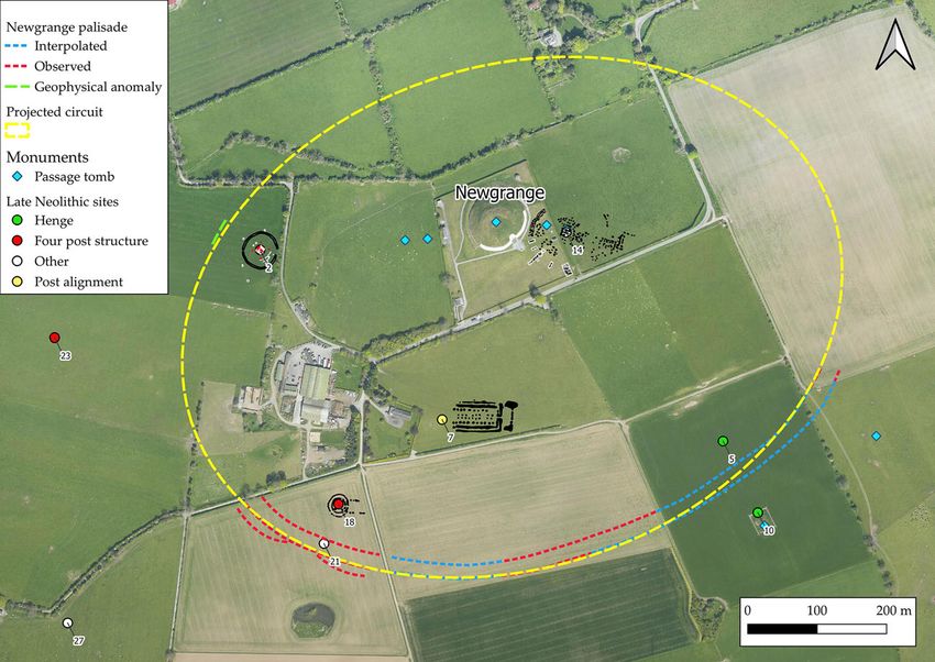
S. Davis & K. Rassmann. BEYOND NEWGRANGE: BRÚ NA BÓINNE IN THE LATER NEOLITHIC
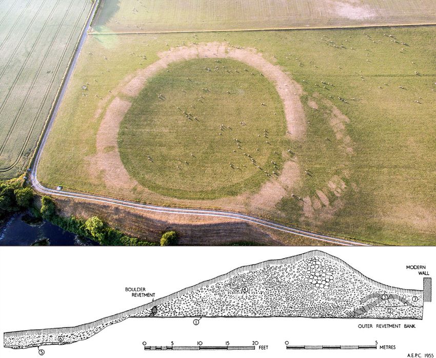
Fig. 3.
Top: Newgrange Site P, July 2018 (aerial photograph courtesy of Anthony Murphy); bottom: Section through bank at the
Giant’s Ring, Ballynahatty (after Collins 1957).
in a unique segmented double ditch form. As in Site which form one side of a rectangular ditched structure
P and Site A, an eastern annex is also evident at with a narrow, extended entrance feature on the west-
ME026-033, in this case as a separate section of seg- ern side. Two large internal post-holes constitute
mented ditch using the same architectural motif as the possible roof supports and suggest this represents
main enclosure. The entrance into the annex is flanked a roofed building. The series of six pits/post-holes cor-
by additional ditch sections, so that here there are responds with a low mound previously identified
three rather than two segments, with substantial pits through LiDAR survey (Davis et al. 2010) and is evi-
or post-holes positioned either side, perhaps forming dent as a parchmark in the 2018 data. This suggests a
a façade. possible low bank at this point only, perhaps as an
Directly opposite the annex, in the position that in anchor for a substantial post setting. Outside the main
Site P is occupied by the narrow second entrance, is a segmented ditch are located two concentric pit/post
rectangular structure. The inner (henge) side of this circles which continue, at least partly, within the east-
comprises a series of six substantial pits or post-holes ern annex. A series of less distinct anomalies present to
7
Downloaded from https://www.cambridge.org/core. IP address: 46.4.80.155, on 03 Nov 2021 at 20:35:39, subject to the Cambridge Core terms of use, available at
https://www.cambridge.org/core/terms. https://doi.org/10.1017/ppr.2021.6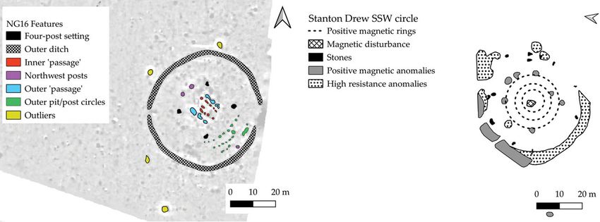
THE PREHISTORIC SOCIETY

                                                                            Fig. 4.
                  Brú na Bóinne henges: left: ME026-094 (Site LP2; Davis et al. 2013; ‘The Univallate Henge’; Condit & Keegan 2018); centre:
                  ME026-033 (‘Dronehenge’); right: Site P. River Boyne to south of image (LiDAR 32-direction hillshade courtesy of Meath
                                                                      County Council).

                  the west of ME026-033 has been named by Condit                                       Site P: this is the largest of all the Brú na Bóinne
                  and Keegan (2018, 58–62; figs 53–7) as ‘the Hidden                                   enclosures identified to date, with an internal diameter
                  Henge’; they consider these to form part of another                                  of 154 m. This site displays no evidence of any bank in
                  large post-built enclosure. However, the exact nature                                aerial survey. A smaller enclosure (prosaically named
                  of these features remains unclear and fragmentary.                                   ‘The Small Enclosure’ by Condit & Keegan 2018) is
                     Another cluster of sites has been identified c. 400 m                             also visible as a cropmark north-north-east of
                  to the east of Site P, adjacent to the probable passage                              ME019-058002, where the LiDAR survey shows it
                  tomb of Site B (Fig. 6). The low mound of Site B1 is                                 to be adjacent to a slight mound. This enclosure is
                  located off-centre within a very low-profile embanked                                anomalously small for an Irish henge monument
                  enclosure, first identified from LiDAR in 2010 (Davis                                and may represent the external ditch of a barrow, a
                  et al. 2013). A clear enclosure ditch is evident at this                             number of which have been identified in geomagnetic
                  site in the 2018 aerial imagery, positioned external to                              survey further east along the river (unpublished data).
                  the previously identified bank. An additional large                                  This close spatial arrangement of an internally
                  circular enclosure (‘The Riverside Henge’: Condit &                                  embanked site together with an apparently un-
                  Keegan 2018) is visible as a cropmark directly                                       embanked enclosure2 offers a striking parallel to the
                  south-west of ME019-058002 and 400 m west of                                         Welsh sites of Llandegai A and B (Houlder 1968;

                                                                                                   8

Downloaded from https://www.cambridge.org/core. IP address: 46.4.80.155, on 03 Nov 2021 at 20:35:39, subject to the Cambridge Core terms of use, available at
https://www.cambridge.org/core/terms. https://doi.org/10.1017/ppr.2021.6
S. Davis & K. Rassmann. BEYOND NEWGRANGE: BRÚ NA BÓINNE IN THE LATER NEOLITHIC
Fig. 5.
Left: ME026-033, otherwise known as ‘The Geometric Henge’ (Condit & Keegan 2018) or ‘Dronehenge’ (Murphy 2019)
(transcribed from aerial imagery © BlueSky 2018 & from orthophotography provided by Ken Williams); right: Transcribed
outline of ME026-033 overlain on Site P, rotation 10.8o anticlockwise. Scale identical
Lynch & Musson 2004; Gibson 2012a), the former of At ME019-094 the slightly flattened ditch outline is
which is potentially early in date (Harding 2003, 15. clearly evident in the geomagnetic survey (Davis et al.
NPL-221; 4420±140 BP, 2675–3515 cal BC; median 2013, 230), although the segmented form that is
probability 3110 BC; recalibrated with IntCal20: apparent in the aerial imagery is not clearly visible,
Stuiver et al. 2020). Both ME019-058002 and the but hinted at with the benefit of hindsight (Fig. 7).
Riverside Henge could be considered atypical henges, The most striking feature here is a NNE–SSW oriented
with Harding (2003) suggesting some of these stylistic linear anomaly within a central high resistance area.
traits (eg, external rather than internal bank as at This is likely to represent a cut feature within the foot-
Llandegai A) are likely to be early in the typological ings of a central mound. Given parallels with ME019-
sequence of British and Irish henges. 058002 and with Site A where probable passage
tombs are enclosed by henge monuments this may rep-
resent the remains of a denuded passage tomb.
HENGE MONUMENTS IN BRÚ NA BÓINNE: A further enclosure, ME019-103, initially described
GEOPHYSICAL SURVEYS as Site LP1 (Davis et al. 2013; Fig. 1, Site 19; Fig. 8) is
To date only three of the embanked enclosures/ located c. 500 m north-east of Site B. Here, geophys-
henge monuments within Brú na Bóinne have been ical survey revealed weakly magnetic ditches both
subject to geophysical survey using modern methods: internal and external to the broad bank. These are
ME019-094 (Site LP2; ‘Univallate Henge’), ME019-103 not visible to the south where they may have been
(Site LP1), and Dowth Henge (Davis et al. 2012; destroyed. To the east the monument is partly
Davis 2013), with additional survey also covering overbuilt by a small circular enclosure, which forms
the area of the Newgrange Pit Circle. The ‘Pit Circle’, part of a substantial complex of probable later prehis-
excavated in part by O’Kelly et al. (1983) and toric features that extends east-north-east from here
Sweetman et al. (1985), has been interpreted by for almost a kilometre. This mirrors the situation
Sweetman (1997) as comparable to British henge noted by Gibson (2010, 245) at Dyffryn Lane,
monuments, despite its perimeter being comprised Pembrokeshire where the site remains a focus for rit-
entirely of pits/post-holes. Geophysical surveys ual activity even after the construction of its closing
within Stout’s (1991) review, while innovative at central mound.
the time, are not of sufficient spatial resolution to At Dowth Henge, multiple phases of geomagnetic
provide useful archaeological information. survey have identified broad ditches both inside and
9
Downloaded from https://www.cambridge.org/core. IP address: 46.4.80.155, on 03 Nov 2021 at 20:35:39, subject to the Cambridge Core terms of use, available at
https://www.cambridge.org/core/terms. https://doi.org/10.1017/ppr.2021.6THE PREHISTORIC SOCIETY
Fig. 6.
Presumed passage tomb of Site B, with mound and enclosure of Site B1 (ME019-058002) to west, ‘Small Enclosure’ to north
and ‘Riverside Henge’ to south-west. Sites numbered after Table 1 (transcribed from aerial imagery © BlueSky 2018;
Anthony Murphy 2020; 32-direction LiDAR hillshade, courtesy of Meath County Council)
outside the main enclosure (Davis 2013; Fig. 9). These Also central within Dowth Henge is a complex
appear to show clear interruption at both entrances, collection of elongated pits which may represent the
suggesting that these are both original features. footings of a demolished passage tomb similar to
Some confusion has arisen because of the construction that centrally located within the Giant’s Ring at
of an ornamental 18th century ‘tree ring’ blocking the Ballynahatty, Co. Down (cf. Hartwell 1991; 1998;
north-eastern entrance, the removal of which has 2002; Rassmann et al. 2019).
caused extensive disturbance. The geomagnetic data A second possible henge, ME020-083 (recorded in
shows berms both inside and outside the henge bank. the SMR as a ring barrow), measuring 46 m in dia-
For most of the perimeter the internal and external meter with a broad internal ditch has been identified
berms are comparatively narrow (c. 5 m); however, at Dowth, 200 m west of Dowth Henge adjacent to
the external berm broadens to 12 m approaching a complex of enclosures of unknown date. The most
the south-western entrance/egress (Davis 2013). striking aspect of these associated features is a small
Within the henge enclosure, in addition to at least rectangular structure, one side of which comprises a
one roughly circular central pit or post arrangement, row of large post-holes, the other, two ‘C’-shaped
a pair of large pits or post-holes spaced 4.5 m apart magnetic anomalies which are likely to represent
is located directly in line with the south-west entrance. heavily burned features (Fig. 10). This has obvious
10
Downloaded from https://www.cambridge.org/core. IP address: 46.4.80.155, on 03 Nov 2021 at 20:35:39, subject to the Cambridge Core terms of use, available at
https://www.cambridge.org/core/terms. https://doi.org/10.1017/ppr.2021.6S. Davis & K. Rassmann. BEYOND NEWGRANGE: BRÚ NA BÓINNE IN THE LATER NEOLITHIC
Fig. 7.
ME019-094 (Site LP2) Transcribed geomagnetic data (with white outline) overlying transcribed 2018 aerial imagery. Central
shaded area represents limits of high resistance anomaly (geomagnetic survey, Kevin Barton; aerial imagery © BlueSky 2018,
red channel only)
similarities to the structure identified by aerial photog- tradition of irregular segmented ditches into the
raphy at the western entrance of ME026-033. late Neolithic. There is still some debate as to the
validity of ‘formative henge’ as a site type, in particu-
lar with the chronological implications of the
Regional parallels: ME026-033 word ‘formative’ – implying that these pre-date con-
Segmented-ditch or causewayed enclosures are ventional henge monuments (Gibson 2012). Given
well-known in the early Neolithic period in Britain this lack of clarity it might be more prudent to describe
(Palmer 1976; Oswald 2001), with ‘formative henges’ these as ‘atypical henges’.
(Harding 2003; Burrow 2010) such as Flagstones, A number of the Boyne monuments likely belong
Dorset (Woodward 1988; Healy 1997) and in this atypical group. The extreme regularity and
Stonehenge Phase 1 (Darvill 2006, 97; Darvill et al. uniformity of the short double ditch segments of
2012) sharing a similar construction technique with ME026-033 finds no clear parallels in either the
these earlier monuments. Similarly, some large henge British or Irish Neolithic, aside from its neighbour
enclosures such as the Ring of Brodgar (Downes ME019-094, which has single regular segments of
et al. 2013, 110) and Mount Pleasant (Linford et al. the same form. The angular form to the north of
2019; Greaney et al. 2020) appear to continue this ME026-033 may argue for the ditches having been
11
Downloaded from https://www.cambridge.org/core. IP address: 46.4.80.155, on 03 Nov 2021 at 20:35:39, subject to the Cambridge Core terms of use, available at
https://www.cambridge.org/core/terms. https://doi.org/10.1017/ppr.2021.6THE PREHISTORIC SOCIETY
Fig. 8.
ME019-103 (Site LP1), transcribed geomagnetic survey showing internal and external ditches, absent to south. Complex of
enclosures obscuring eastern perimeter (LiDAR 32-direction hillshade, data courtesy of Meath County Council)
dug in gangs rather than as a single unified project, as include Meini Gwyr, Carmarthenshire (cf. Darvill &
has been suggested in causewayed enclosures (Startin Wainwright 2003, 36–8) where geophysical survey
& Bradley 1981). revealed a series of pits/post-holes described by the
There are many parallels for henge monuments authors as ‘more or less under the centre of the bank’
enclosing either stone or timber settings; however, (ibid., 29) and Blackshouse Burn, Lanarkshire where
the motif of a ditch within a palisade is unusual the largely stone bank overlay and incorporated
(Gibson 2004), although a timber circle was con- a timber palisade, dating to the later Neolithic
structed around the small henge at Forteviot (GU-1983; 4035±55 BP; 2864–2410 cal BC; Lelong &
(Henge 1; Brophy & Noble 2012) and Milfield Pollard 1998; recalibrated using IntCal20; Stuiver
North was surrounded by a ring of pits (Harding et al. 2020). Recent research at Durrington Walls
1981). If the palisade at ME026-033 is viewed as a (Gaffney et al. 2018, 264–6) has also demonstrated
precursor to bank construction, mirroring as it that an earlier monument comprising a series of
does the position of the earthen bank at Site P, then substantial post-holes was overbuilt by and perhaps
parallels could also be drawn with British sites where formalised by the construction of the later earthen
sub-bank enclosures have been identified. These henge enclosure.
12
Downloaded from https://www.cambridge.org/core. IP address: 46.4.80.155, on 03 Nov 2021 at 20:35:39, subject to the Cambridge Core terms of use, available at
https://www.cambridge.org/core/terms. https://doi.org/10.1017/ppr.2021.6S. Davis & K. Rassmann. BEYOND NEWGRANGE: BRÚ NA BÓINNE IN THE LATER NEOLITHIC
Fig. 9.
Dowth Henge and wider area, transcribed geomagnetic data. ME020-083 visible to west of henge (LiDAR 32-direction
hillshade courtesy of Meath County Council overlain by Local Relief Model, courtesy of Ralf Hesse)
Fig. 10.
Left: Dowth rectangular structure (Fig. 9; transcribed geomagnetic data); right: rectangular structure at western side of
ME026-033, same scale (aerial imagery ©BlueSky 2018)
13
Downloaded from https://www.cambridge.org/core. IP address: 46.4.80.155, on 03 Nov 2021 at 20:35:39, subject to the Cambridge Core terms of use, available at
https://www.cambridge.org/core/terms. https://doi.org/10.1017/ppr.2021.6THE PREHISTORIC SOCIETY
EMBANKED ENCLOSURES & STRUCTURAL Dowth Henge has undergone significant modification
DEVELOPMENT and embellishment since its original construction.
From the range of earthworks preserved and evidence As regards formal access to the interior of these
from aerial and geophysical survey it is possible that enclosures, at the Newgrange Pit Circle, Site P,
some of the enclosures in Brú na Bóinne were only ME026-033 and at Dowth Henge, there are clearly
ever surrounded by low banks and that the raising formalised points of access/egress. At Sites P and
of banks to form substantial earthworks was limited Dowth Henge there are two apparent openings;
to only a few monuments. However, once again exca- however, in some cases the boundaries are essentially
vation is required to understand fully the sequence of permeable at any point without palisading and
development at these sites. planking. It may be that, as at the western opening
At Site ME019-094 (Site LP2; Fig. 7) geophysical of Site P, these formal access points exist but are unela-
survey and aerial photography imply the monument borated and potentially very narrow, or that they
had very insubstantial banks only, the external parch- have been deliberately blocked upon the site’s
mark suggesting a bank width of c. 6.5 m, comparable abandonment (cf. Brophy & Noble 2012).
to the outermost parchmark at Site P. At ME026-033 From currently available data it is impossible to say
there is no evidence that the monument was ever how many of the Brú na Bóinne henges were in con-
embanked; the same is true of the ‘Riverside Henge’. current use (or indeed, what or when that use might
It is suggested that where banks did occur they existed have been); however, the large number of these sites
at most in the form of Collins’s (1957) outer gravel in close proximity suggests that perhaps each was used
‘guide enclosure’, most likely representing an early for a limited period only rather than them all being
structural phase. While these enclosures are clearly constructed and in use simultaneously. In terms of
delimiting space, they are unlikely for the most part, palisaded structures, these would have had a finite
to be controlling any visual aspect of the landscape lifespan. The frequently-cited estimate of Wainwright
nor could they have done so without significant addi- and Longworth (1971, 224–5) of a rate of wastage of
tional timber construction. An exception to this is 15 years per inch for oak posts means that without
Dowth Henge which, owing to its elevated position replacement of posts it is likely that an enclosure of
and substantial banks, offers a truly enclosed space, this type would be in substantial disrepair within a
visually isolated from the outside world. few centuries at most. Beyond this lifespan perhaps
Site P and ME026-033 possess a remarkable degree some of these monuments were further commemo-
of similarity to one another (Fig. 5) and differ princi- rated by the raising of significant earthen banks,
pally in that Site P is enclosed by at least two phases of emphasising the line of the former palisade.
earthen bank while ME026-033 is likely to have
instead been enclosed by timber uprights, perhaps
planked or connected with screens. It is also possible TIMBER ARCHITECTURE: LATE NEOLITHIC/EARLY
that the segmented ditches at this site could have held BRONZE AGE FOUR-POSTER STRUCTURES
short lengths of palisade or planking. The bank at Site Aerial and geophysical surveys to date have
P may effectively be formalising the double post enclo- identified at least six four-poster or ‘square-in-circle’
sure seen at ME026-033. The principal difference is monuments within Brú na Bóinne (Fig. 11), in addi-
with the structure of the annex: at Site P this is pre- tion to the ones excavated at Knowth (Eogan &
served as an earthen rampart while at ME026-033 Roche 1994) and possibly at Newgrange (Sweetman
the post circuits run within the segmented ditch which et al. 1987). One of these has recently been identified
defines the innermost boundary of the annex. Dowth through aerial survey (ME019-067002; K. Williams
Henge sees still further elaboration in the form of pers. comm.; Condit & Keegan 2018, 25–32), with
more significant internal and external ditches, the other five identified through large-scale geomag-
two clear and opposing entrances, and substantial netic survey. Most of these monuments are in the
raised banks. This may imply that it falls late in the area between Knowth and Newgrange and all are
construction sequence of henges in Brú na Bóinne, aligned in an easterly or south-easterly direction
in keeping with generally accepted dating evidence (Table 2). These have been referred to as possible
within a British context (Gibson 2012a, 13–20), or that mortuary enclosures (eg, Hartwell 1991, 11;
14
Downloaded from https://www.cambridge.org/core. IP address: 46.4.80.155, on 03 Nov 2021 at 20:35:39, subject to the Cambridge Core terms of use, available at
https://www.cambridge.org/core/terms. https://doi.org/10.1017/ppr.2021.6S. Davis & K. Rassmann. BEYOND NEWGRANGE: BRÚ NA BÓINNE IN THE LATER NEOLITHIC
Fig. 11.
Brú na Bóinne four-poster structures drawn to same scale. 1. Knowth four-post structure, excavated outline (redrawn after
Eogan & Roche 1994); 2. ME019-067002 (transcribed from aerial image); 3. DOW61; 4. NG39; 5. NG10; 6. NG16
(transcribed from geomagnetic data)
Condit & Keegan 2018, 25) although interpretation on one side, usually including a pair of post-holes or
of them is still very much a matter for debate (see pits and possibly reflecting an entrance arrangement.
discussion in Carlin & Cooney 2017). In the excavated example at Knowth, this comprises
In addition to the common motif of a central rect- an eastern post-built ‘porch’ (Eogan & Roche 1994)
angular setting that would have comprised four or embellished façade, with ME019-067002 and
substantial posts, all display a degree of enhancement NG10 also showing evidence of extended entrance
15
Downloaded from https://www.cambridge.org/core. IP address: 46.4.80.155, on 03 Nov 2021 at 20:35:39, subject to the Cambridge Core terms of use, available at
https://www.cambridge.org/core/terms. https://doi.org/10.1017/ppr.2021.6THE PREHISTORIC SOCIETY
TABLE 2: APPROXIMATE DIMENSIONS AND AZIMUTH OF FOUR-POST STRUCTURES IN BRÚ NA BÓINNE
Site no. Site name Length Width Azimuth
2 NG16 16.5 18.2 137.5
3 NG10 5.2 6.9 143.4
11 Knowth 4-post structure 3.5 3.9 91.5
18 ME019-067002 10.4 11.7 95.5
23 NG39 7.3 8.6 115.8
24 DOW61 7.2 9.5 92.8
In all cases the central four-post setting is laterally compressed.
ME019-046005 excluded as it is not possible to determine dimensions of either four-post setting or azimuth.
Fig. 12.
Left: Knowth four-post structure (redrawn from Eogan & Roche 1994); right: ME026-033 – eastern annex (transcribed
from aerial photography)
avenues to the east and south-east respectively. incorporated into its fill, as at Ballynahatty
Elsewhere in Ireland such aggrandisement of the (Hartwell 1998). This is also the case at the partially
eastern and south-eastern sides of monuments excavated Western Circle at Newgrange (Sweetman
of this period has also been noted (eg, Ballynahatty; et al. 1987, 291), where none of the outer (Group
Hartwell 1998; 2002; Balgatheran, Co. Louth; 4) post-holes included packing stones or larger pieces
Ó Drisceoil 2009). The enhancement of entrance fea- of charcoal. As at ME019-067002, DOW61 appears
tures seen at these sites could be considered to be set within a larger enclosure and possesses traces
analogous with the annex structures seen at Site A, Site of an unusual ‘double-ditched entrance’ feature (see
P and ME026-033 (Fig. 12). Fig 17), discussed further below.
In ME019-067002 the post-circle is doubled, with a The final example of these four-post structures
parchmark between the two circuits suggesting the (NG16) represents a greatly embellished form. This
presence of a bank. This monument appears to be large, circular enclosure appears to be open to the east,
enclosed by a closely-spaced oval palisade c. 95 m facing towards Newgrange (Figs 11 & 13) and may
in diameter (Condit & Keegan 2018, 29). DOW61 have an opposing entrance to the west (Rassmann
and NG39 also appear to possess a double circuit of et al. 2019). The central area comprises two parallel
posts although only the façade is visible in geomag- short settings of pits or post-holes, oriented in a
netic survey. This suggests the inner post-ring may north-west to south-east direction and enclosing a sec-
have been burned or have burned material ondary arrangement of smaller pits/post-holes. To the
16
Downloaded from https://www.cambridge.org/core. IP address: 46.4.80.155, on 03 Nov 2021 at 20:35:39, subject to the Cambridge Core terms of use, available at
https://www.cambridge.org/core/terms. https://doi.org/10.1017/ppr.2021.6S. Davis & K. Rassmann. BEYOND NEWGRANGE: BRÚ NA BÓINNE IN THE LATER NEOLITHIC
Fig. 13.
Newgrange Site NG16 (transcribed geomagnetic data) compared with SSW circle at Stanton Drew; identical scale (redrawn
after David et al. 2004)
north-west of these lie two large pits or post-holes, Regional parallels: Newgrange Site NG16
mirrored at Balgatheran Building 3 among other sites The architectural motif of squares within circles
(see Ó Drisceoil 2009, 94; Smyth 2014, 88) which, has been elaborated upon in detail elsewhere (eg,
along with the central setting, create a defined axis Pollard 2012, 100–2). Likewise, late Neolithic four-
of symmetry. To the south-east are traces of up to post structures have been reviewed elsewhere in both
three concentric rings of pits or post-holes, flattened Scotland (Noble et al. 2012) and in Ireland (in Brophy
to this direction. This is paralleled in ME019- 2016, 217–20; Smyth 2014; Carlin & Cooney 2017,
067002 and also at BHN6 at Ballynahatty where 42–6).
the excavated post-holes towards the entrance area The scale and complexity of the Newgrange site
were packed with burned material and charcoal sets it apart from other four-post structures thus far
(Hartwell 1998). The four-post arrangement at recorded within Ireland and Scotland. However,
NG16 measures 18.2 × 16.5 m, approximately 1.5 geophysical survey at the SSW circle at Stanton
times the size of any other similar structure in Drew (David et al. 2004; Linford et al. 2018) provides
Ireland. Externally NG16 is surrounded by several a close parallel. Here, the outer stone circle (c. 44 m
highly magnetic anomalies, perhaps large post-holes diameter) encloses three concentric rings of magnetic
or stone sockets, similar to outliers in a stone circle. anomalies, interpreted as pits filled with ‘magnetically
This ‘lithicisation’ of timber settings has also been enhanced material’ (Fig. 13; David et al. 2004, 350).
noted at Stanton Drew SSW (Fig. 13; David et al. The Stanton Drew enclosure incorporates a series of
2004), Machrie Moor (Haggarty 1991), and on a larger anomalies on the boundary of the outermost
smaller scale at Knowth (Eogan & Roche 1997, ring, four of which form a large square setting with
103). Preliminary archaeo-astronomical assessment sides measuring c. 17 m in length. Further anomalies
(Frank Prendergast pers. comm.) suggests the central to the north-east create an axis of symmetry, as seen in
setting of NG16 is, like Newgrange, aligned on the some Irish four-post structures (see Smyth 2014, 88).
winter solstice sunrise. While the east–west orientation Another possible parallel can be seen at Coneybury
of the external ditch is shared with the ‘Great Linear Henge, Wessex (Richards 1990, 123–58; 259; Pollard
Palisade’ (see below) and, as noted by Leigh et al. 2012, 102). Here, a central linear setting of six post-
(2018), closely aligns on the spring and summer equi- holes and associated shallow features was excavated,
nox sunrises, this may be a consequence of its position with an additional two, more closely spaced post-holes
relative to Newgrange as opposed to a deliberate apparently ‘flanking the axis of symmetry’ of the
astronomical trait (cf. Ruggles 1997). central setting (Richards 1990, 137), in this case
17
Downloaded from https://www.cambridge.org/core. IP address: 46.4.80.155, on 03 Nov 2021 at 20:35:39, subject to the Cambridge Core terms of use, available at
https://www.cambridge.org/core/terms. https://doi.org/10.1017/ppr.2021.6THE PREHISTORIC SOCIETY
Fig. 14.
Newgrange and the ‘Great Palisade’. Circuit marked in red is recorded within aerial imagery; blue interpolated; green section
visible in geomagnetic survey. Dashed yellow line is a projection of potential entre circuit (aerial imagery ©BlueSky 2018)
directly aligned with the entrance of the enclosure to Condit and Keegan (2018, 33) ‘The Great Palisade’,
the east. The central setting at Coneybury was sur- they suggest this could form a triple-palisaded enclo-
rounded by a ring of shallow post-holes. Based on sure approximately 900 m on its long axis with a
ceramic evidence, Ellison (1990, 149) suggests that post spacing of 1.5–2 m. A short section of palisade
the enclosure at Coneybury post-dates the central with similarly spaced magnetic anomalies is visible
setting. It is notable that these two parallels belong due west of Newgrange, potentially encompassing site
not to the Irish or Scottish corpus, but to southern NG16. The visibility of some sections of this palisade
England. within the geomagnetic survey perhaps echoes the
situation at Mount Pleasant where some portions of
the palisade were destroyed by fire (Wainwright
TIMBER ARCHITECTURE IN BRÚ NA BÓINNE: 1979, 240).
PALISADED ENCLOSURES While Neolithic palisaded enclosures are well-docu-
As well as the earthen enclosures identified or con- mented from Britain (Whittle 1997; Gibson 1998a;
firmed by aerial survey in 2018 perhaps the most 1998b; 2004; Hale et al. 2009; Noble & Brophy
remarkable discovery was an enormous palisaded 2011; Millican 2016, 47–52) and to a lesser extent
enclosure that appears to enclose a large part of the Ireland (Grogan & Roche 2002), the scale of this mon-
Newgrange precinct (Figs 14 & 15). Dubbed by ument is exceptional. Again, detailed discussion is
18
Downloaded from https://www.cambridge.org/core. IP address: 46.4.80.155, on 03 Nov 2021 at 20:35:39, subject to the Cambridge Core terms of use, available at
https://www.cambridge.org/core/terms. https://doi.org/10.1017/ppr.2021.6S. Davis & K. Rassmann. BEYOND NEWGRANGE: BRÚ NA BÓINNE IN THE LATER NEOLITHIC
Fig. 15.
Detail of the ‘Great Palisade’ showing three palisade circuits (aerial image courtesy of Anthony Murphy, May 2020)
hampered by a lack of excavation and hence chrono- assuming this was an important part of their function.
logical control: in scale and complexity the only other This would require further significant timber resour-
parallels in Ireland are the Iron Age earthworks of ces. The origin of such prodigious quantities of
The Dorsey and the Black Pig’s Dyke, gigantic pali- timber remains unclear but it is unlikely to have been
saded earthworks, the function of which remains available from within the immediate area of Brú na
enigmatic (Lynn 1977; Hurl & McSparron 2004). Bóinne (Davis 2017). As such, its felling, splitting,
While the focus of the Newgrange palisade on so sig- and transport to site may well have been as monumen-
nificant a Neolithic complex might argue for a late tal a task as that of quarrying and moving orthostats
Neolithic date, there is considerable evidence of and kerbstones in previous generations.
Iron Age activity within Brú na Bóinne (eg, Eogan The closest parallels to the massive Newgrange
1968, 365–73; 1974, 68–87; 2012; Carson & enclosures in the Irish Neolithic are the timber struc-
O’Kelly 1977; Bendry et al. 2013) and the idea that tures at Ballynahatty, Co. Down (Hartwell 1998);
monuments might have been either modified or these incorporate some features that closely resemble
constructed during this period can certainly not be those evident at Newgrange albeit on a far smaller
discounted. scale. The large, double-circuit four-post timber
The only Neolithic palisaded enclosure of compara- enclosure of Ballynahatty BHN6 is mirrored by the
ble size across Britain and Ireland is Hindwell in similar, although larger structure ME019-067002 at
Wales, with approximate dimensions of 880 m Newgrange. At Ballynahatty, this lies off-centre within
east–west by 540 m north–south and enclosing an the double oval timber palisade of BHN5, in the same
approximate area of 34 ha (Gibson 1998a). It is signif- manner that ME019-067002 lies off-centre within the
icantly smaller than the projected area of the likely circuit of the Newgrange palisades. The pro-
Newgrange enclosure (55 ha). Considering that jected triple-palisaded enclosure, while incorporating
Hindwell itself is perhaps four times the size of its Newgrange and ME019-067002 apparently intersects
nearest rival (ibid., 76), this represents timber both the henge at Site A and the Newgrange cursus.
monumentality on a massive scale and complexity. It is possible that the point of intersection with Site
At Hindwell, for a single circuit of palisade, Gibson A is responsible for the scarping of this enclosure
(1999, 154) estimates construction materials in the noted to the north-west by Davis et al. (2013).
order of 1410 posts and 6300 tonnes of oak. He also While Hale et al. (2009, 286) highlight that in many
suggests that enclosures of this type, where posts are cases palisaded enclosures are overlooked by large
not contiguous, are likely to have been planked in Neolithic mounds, in this case it would seem possible
order to effectively manage access to the interior, that the triple palisade extends to actually enclose the
19
Downloaded from https://www.cambridge.org/core. IP address: 46.4.80.155, on 03 Nov 2021 at 20:35:39, subject to the Cambridge Core terms of use, available at
https://www.cambridge.org/core/terms. https://doi.org/10.1017/ppr.2021.6THE PREHISTORIC SOCIETY
mound of Newgrange in addition to a substantial area 95–7) and bears a striking similarity to the undated
around the tomb. Elsewhere within Brú na Bóinne the Scottish free-standing timber avenues reviewed by
enclosure of passage tombs is a common motif but the Millican (2016, 41–3).
palisade here would enclose not just a single tomb but The most remarkable of these linear structures was
an entire precinct, potentially delimiting an enormous discovered through geophysical survey in 2015,
ceremonial space between Newgrange and the river. extending for almost 200 m east–west on a low ridge
This idea is possibly echoed in the enclosing ramparts beneath the main shale outcrop on which Newgrange
described by Bergh (2000) at Knocknarea, Co. Sligo, stands (Leigh et al. 2018; Fig. 16). Briefly, the struc-
where the entire plateau appears to have been ture comprises two parallel rows of regularly spaced
enclosed by earth and stone banks. Similar large pre- pits or post-holes, larger ones to the outside (5–7 m
cincts appear to have been defined at some Irish apart), smaller to the interior (4.5–5 m apart),
‘Royal’ sites, in particular at Rathcroghan, Co. enclosed within a regular double rectilinear enclosure.
Roscommon (Waddell et al. 2009) and Uisneach, A narrow entrance feature, c. 3 m across is located to
Co. Westmeath (Schot 2011), again unexcavated the east. A second probable post-built linear feature
and undated, but associated with probable later pre- runs north–south, perpendicular to the long axis of
historic landscapes. the structure and perhaps controlling access to the
entrance. Recent test excavations yielded a prelimi-
nary date of 2829–2468 cal BC from oak charcoal
TIMBER ARCHITECTURE IN BRÚ NA BÓINNE: (heartwood) recovered from the basal fill of the outer
LINEAR POST ALIGNMENTS ditch (UBA-38707; 4034±33 BP; Leigh et al. 2019;
At least four linear post alignments have now been recalibrated using IntCal20; Stuiver et al. 2020);
recorded in the wider area, including one each at two further radiocarbon dates on animal bone were
Dowth and Oldbridge to the south side of the river attempted but failed owing to poor collagen preserva-
and two examples at Newgrange (Fig. 16). While pub- tion (Matthew Stout pers. comm.). Given the nature
lished in a preliminary form (Smyth 2009, 22), no of the material available for selection this date
high-quality image of the geomagnetic survey from should obviously be treated with a degree of caution.
the Newgrange Pit Circle/cursus area is currently Although this monument has been described as a
available for analysis. The pit circle itself is not clearly ‘hybrid cursus’ (Leigh et al. 2019), the late Neolithic
visible in the available geomagnetic data; however, a date and internal partitioning make it unlike other cur-
double pit or post-alignment is evident running in a sus monuments. While cursus monuments in Ireland
north-west to south-east direction and terminating are very much under-researched (Corlett 2014;
to the south-east in a perpendicular double pit or post Kenny 2014) and unexcavated, none of those so far
row. At the north-west end of the post alignment are identified has evidence for internal pits, double
two short parallel pit or post-rows, potentially with ditches, or a façade.
some indications of burning. Part of a possible fifth These post alignments most likely represent ceremo-
post alignment was partially excavated by O’Kelly nial avenues: both the Dowth example and that
south-west of Newgrange (O’Kelly et al. 1983), associated with the Newgrange Pit Circle are closely
although the location of this at the western limit of associated with both passage tombs (Site Z; the
his excavation area and the lack of dating evidence recently discovered tombs at Dowth Hall) and henge
hampers detailed interpretation. monuments (eg, Dowth Henge) or henge-like struc-
The Oldbridge alignment occupies an elevated posi- tures (the Newgrange Pit Circle). Post alignments
tion on the south side of the Boyne. It comprises two are recorded within a number of significant late
parallel rows of regularly spaced pits or post-holes Neolithic landscapes in Britain and Ireland; however,
which extend for c. 40 m in a north-west to south-east in some ways they mirror discussion of henge monu-
direction. The central pits/post-holes are enclosed ments in that the one thing that is agreed upon is that
within a weakly magnetic rectilinear feature. This they are ‘extremely heterogeneous’ (Waddington
alignment has clear similarities with those identified 1997, 22) and are associated with ‘a range of features
at Newgrange and Dowth. It may also be analogous of varying date’ (ibid., 24). The earliest dated exam-
with an undated structure excavated at Ballingowan, ples, like the Newgrange site, date from the late
Co. Kerry (Moloney 2013; Long et al. 2020, 39–42, Neolithic and appear to be associated with Grooved
20
Downloaded from https://www.cambridge.org/core. IP address: 46.4.80.155, on 03 Nov 2021 at 20:35:39, subject to the Cambridge Core terms of use, available at
https://www.cambridge.org/core/terms. https://doi.org/10.1017/ppr.2021.6You can also read