CHILDA - Czech Historical Landslide Database - Natural ...
←
→
Page content transcription
If your browser does not render page correctly, please read the page content below
Nat. Hazards Earth Syst. Sci., 21, 2581–2596, 2021
https://doi.org/10.5194/nhess-21-2581-2021
© Author(s) 2021. This work is distributed under
the Creative Commons Attribution 4.0 License.

CHILDA – Czech Historical Landslide Database
Michal Bíl1 , Pavel Raška2 , Lukáš Dolák3,4 , and Jan Kubeček1
1 CDV  – Transport Research Centre, Brno, 636 00, Czechia
2 Department of Geography, J. E. Purkyně University, Ústí nad Labem, Czechia
3 Department of Geography, Masaryk University, Brno, Czechia
4 Global Change Research Institute of the Czech Academy of Sciences, Brno, Czechia

Correspondence: Michal Bíl (michal.bil@cdv.cz)

Received: 12 April 2021 – Discussion started: 14 April 2021
Revised: 15 July 2021 – Accepted: 28 July 2021 – Published: 26 August 2021

Abstract. National and regional historical landslide             ley, 2018), these databases also make it possible to identify
databases are increasingly viewed as providing empirical ev-     changes in hotspots of landslide occurrence and the charac-
idence for the geomorphic effects of ongoing environmental       ter of their impacts (Salvati et al., 2015; Klose et al., 2016).
change and for supporting adaptive territorial planning. In      In both these respects, the historical databases complement
this work, we present the design and current content of the      current landslide inventories that can be used to trace the
Czech Historical Landslide Database (CHILDA), the first of       spatial patterns in landslide occurrence and their causative
its kind for the territory of Czechia (the Czech Republic).      factors (Van Den Eeckhaut and Hervás, 2012; Herrera et al.,
We outline the CHILDA system, its functionality, and             2018; Marc et al., 2018). Within the landslide hazard and
technical solution. The database was established by merging      risk assessments, the historical landslide databases provide
and extending the fragmented regional datasets for highly        evidence as it is generally assumed that past landslide occur-
landslide-prone areas in Czechia. Currently, the database in-    rence frequencies may be used to describe the probabilities
cludes 699 records (619 landslides, 75 rockfalls, and 5 other    of landslide occurrence in the near future (Remondo et al.,
movement types) encompassing the period from the oldest          2008; Van Den Eeckhaut et al., 2009; Wu and Yeh, 2020).
determined records (1132) up to 1989, which represents an           Connecting these directions, increasing attention has been
important cultural, political, and socioeconomic divide.         also paid to revealing the vulnerabilities and adaptive be-
                                                                 haviours of past societies regarding landslides (Tropeano and
                                                                 Turconi, 2004; Caloiero et al., 2014; Klose et al., 2016;
                                                                 Raška, 2019; Rossi et al., 2019; Klimeš et al., 2020). These
1   Introduction                                                 studies argue that historical landslide databases – if ap-
                                                                 proached critically – may inform current efforts for adap-
Historical landslide inventories and databases are among the     tive management of landslide risks (Klose et al., 2016; Raška
key challenges within landslide risk reduction efforts as they   and Dubišar, 2017). Historical landslide databases have been
fill the gap between, on the one hand, the landslide occur-      recently established for various countries and regions, for
rence in the past environments studied with the use of vari-     instance, in Italy (Guzzetti et al., 1994; Piacentini et al.,
ous documentary proxies and, on the other, the present-day       2018), Nicaragua (Devoli et al., 2007), USA (Elliott and
landslides, for which different monitoring and mapping tech-     Kirschbaum, 2007), Norway (Hermanns et al., 2013), the
niques may be used (e.g. Glade et al., 2001; Raška et al.,       UK (Taylor et al., 2015), Germany (Damm and Klose, 2015),
2015; Piacentini et al., 2018). In light of the recent global    and Portugal (Pereira et al., 2014), most of them covering ca.
climate change, the historical landslide databases contribute    the last 150 years but some databases also including scarce
a better understanding to changes in various meteorologi-        records dating back as early as the twelfth century.
cal triggers of landslides in different environmental settings      The aim of this work is to present the Czech Histori-
(Gariano and Guzzetti, 2016; Caracciolo et al., 2017). Given     cal Landslide Database (CHILDA), a project that unified
the severe impacts of landslides on society (Froude and Pet-

Published by Copernicus Publications on behalf of the European Geosciences Union.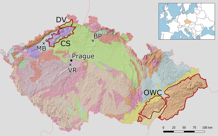
2582                                                           M. Bíl et al.: CHILDA – Czech Historical Landslide Database

and significantly extended the fragmented existing regional        the 1997 landslide period as many as 3700 individual land-
databases and established an open-access and concurrently          slides were mapped in that region (Krejčí et al., 2002). High
updated map inventory of historical landslides in Czechia.         numbers of reactivated landslides were also further iden-
The presented database thus further fills in the gap of miss-      tified during the periods of intense landsliding which fol-
ing historical databases for central European mid-mountain         lowed, specifically in 2006 (Bíl and Müller, 2008), and 2010
environments (Damm and Klose, 2015). Within this paper,            (Pánek et al., 2011). The Registry of Slope Deformations of
landsliding is used as a generic term covering all major types     the Czech Geological Survey (2012a, http://www.geology.cz,
of rapid mass movements (cf. Hungr et al., 2014) that are          last access: 18 August 2021) contains in all approximately
usually recorded in the documentary data. Slow slope de-           14 500 landslides in this area of the Czech part of the OWC
formations are not studied here since they usually did not         (7200 km2 ), which was 82 % of all the landslides registered
cause rapid harm to society and have not been registered by        within Czechia (Bíl et al., 2016).
past societies. For CHILDA (2021) content, we only differ-             In NW Czechia, two major areas display high landslide
entiate between the three following groups according to ma-        susceptibility: (i) the České středohoří Mts (CS) built by
jor mechanisms: (a) landslides sensu stricto (also including       Neogene volcanic rocks underlain by Mesozoic weak sed-
spreading and flows) and (b) rockfalls (including topples) in      iments (Cajz, 1999) with a susceptibility to landsliding
solid bedrock, while (c) all remaining mass movements are          (Hroch et al., 2002; Raška et al., 2014a; CHMI, 2021) and
grouped as “other”. This rough classification is used since the    (ii) the Děčínská highland (DV) built by uplifted and dis-
documentary data often do not allow for detailed and reliable      sected Mesozoic sandstones, which are prone to rockfalls and
identification of the mass movement type.                          toppling (Kalvoda and Balatka, 1995; Zvelebil et al., 2005).
   In the following sections, we will first review the previ-          Other parts of Czechia are not as susceptible to landslid-
ous studies on historical landslides in Czechia with empha-        ing to an extent comparable to the above-mentioned three
sis given to attempts to establish systematic historical land-     primary landslide areas (OWC, CS, DV). Landslide activity
slide databases. We will then outline the availability of the      has been long recorded in the Neogene and Quaternary sedi-
documentary sources and present a design of CHILDA. Fi-            ments of the Most basin (MB, see Fig. 1), along the banks of
nally, the current content of this database and its complete-      the Ohře/Eger River, and in the anthropogenic landscape at
ness will be presented in a comparative perspective along          the edges of the open-pit brown coal mines (e.g. Burda et al.,
with discussion of its future directions. Although CHILDA is       2013). Another area prone to landslides is in central–eastern
an open database, the last analysed year was set to 1989 for       Czechia in the Mesozoic sandstones of the Bohemian Par-
the purpose of this study. The year is considered an impor-        adise (BP), which form steep elevations and rockfall-prone
tant cultural, political, and socioeconomic divide in the re-      areas (e.g. Forczek, 2008). Rockfalls occur along a num-
cent history of Czechia, turning the country into a democratic     ber of deeply incised valleys in the Bohemian Massif (e.g.
regime. For the landslide research this shift implies important    along the Vltava/Moldau River valley south of Prague – VR:
change in public data availability as well as in approaches to     concentration of rockfalls along the Vltava River) as well as
scientific inquiry regarding landslides. While CHILDA re-          some transportation corridors, particularly along rail tracks
mains open for newer records after 1989, its main objective        (as documented in a database of road and railway blockages
is to collect and present the data on historical landsliding be-   due to natural processes, http://www.rupok.cz, last access:
fore this date and known only from documentary data.               19 August 2021, Bíl et al., 2017).

                                                                   2.2     Historical landslide research in Czechia
2     Landslides in Czechia
                                                                   2.2.1    The beginning of landslide research in Czechia
2.1    Landslide predispositions in Czechia
                                                                   The first works on landsliding in Czechia are dated to the
Despite the fact that Czechia can be generally considered          eighteenth century (e.g. Strnad, 1790), followed by works
a low-risk country, given the relatively low landslide fre-        emerging as of the end of the nineteenth century (Zahálka,
quencies and impacts (Klimeš et al., 2017), the country dis-       1890; Dědina, 1896; Woldřich, 1899) and at the beginning of
plays high spatial variability in landslide occurrence with        the twentieth century (Čermák, 1912; Dědina, 1916). More
some highly landslide-prone regions due to their predispo-         systematic landslide research started, however, in the 1920s
sition and presence of causative factors. Among the areas the      with the work of Záruba (1922, 1923, 1926, 1938). Partic-
most affected by landslides are the Outer Western Carpathi-        ular attention was paid to landslide areas in the Pavlovské
ans (OWC), NW Czechia (České středohoří Mts, Děčínská         vrchy situated in OWC (Jüttner 1931, 1937; Stejskal, 1931;
vrchovina), and several of the scattered spatially limited ar-     Woldřich and Stejskal, 1934). Záruba and Myslivec (1942)
eas across the country (see Fig. 1).                               documented landslides related to transportation infrastruc-
   The eastern part of Czechia, OWC, is particularly sus-          ture in OWC. Landsliding in the broader area of the city of
ceptible to landsliding. As a consequence, for example, of         Zlín (OWC) was described by Krejčí (1943). The first Czech

Nat. Hazards Earth Syst. Sci., 21, 2581–2596, 2021                                 https://doi.org/10.5194/nhess-21-2581-2021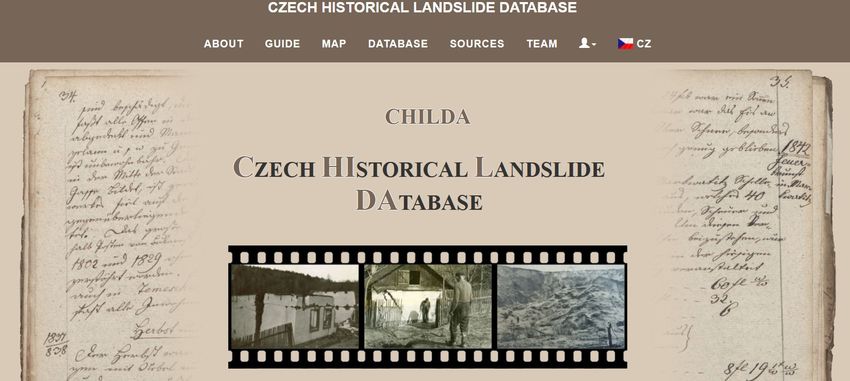
M. Bíl et al.: CHILDA – Czech Historical Landslide Database                                                                        2583

Figure 1. Delimitation of the primary areas where landsliding concentrates in Czechia. Neogene volcanic rocks (CS – České středohoří
Mts), Mesozoic sandstones (DV – Děčínská vrchovina), Neogene and Quaternary sediments (MB – Most Basin) on the west, Mesozoic
sandstones in central parts of Czechia (BP – Bohemian Paradise sandstones), and Mesozoic and Tertiary flysch belt (OWC – Outer Western
Carpathians) in the east of Czechia represent the most susceptible parts to landsliding. VR – concentration of rockfalls along the Vltava
River; https://mapy.geology.cz/arcgis/rest/services/Inspire/GM2_5mil/MapServer (last access: 19 August 2021; Czech Geological Survey
Map Server, 2012b). © Czech Geological Survey.

modern landslide classification was published by Záruba and               For the Outer Western Carpathians, Bíl et al. (2014) stud-
Mencl (1954).                                                          ied historical landsliding in an area around the village of
                                                                       Halenkovice (central part of OWC). They analysed docu-
2.2.2   Systematic works describing landslide occurrence               mentary data and chronicles and interviewed eyewitnesses.
        based on historical data                                       They determined dates for 120 individual landslides. The
                                                                       oldest records were found in local chronicles and described
We present here an overview of works from Czechia which                landsliding in two villages (Jankovice and Košíky) in the
created at least a regional landslide chronology based on              close vicinity of Halenkovice in 1915. Bíl et al. (2020) cre-
documentary data analyses. The only systematic studies of              ated an overview of the chronology of landsliding in the
landslide occurrence, based on a range of historical sources           Pavlovské vrchy, an area at the Czech–Austria border be-
in Czechia, were conducted by Špůrek (1967, 1972, 1985).              longing to the Western Carpathian Flysch Belt. They deter-
These studies were mainly based on the investigation of arti-          mined dates for 30 historical landslides. The first written re-
cles published in national newspapers covering the territory           source relates to a landslide record dating back to 1663.
of former Czechoslovakia (and also mentioning landsliding                 In NW Czechia, Raška et al. (2015) established a regional
all over the world). The recorded information includes each            historical landslide database which was compared with the
landslide date, location, type, and amount of damage as well           central part of OWC in respect to the data availability and
as the bibliographic source.                                           content. The multi-hazard database for the latter half of the
   There have not been any other attempts to prepare an                nineteenth century (Raška and Dubišar, 2017) allowed for
overview of dated landslides for all of Czechia which would            an exploration of the relative direct impacts of landslides on
follow up on Špůrek’s work from 1970 onwards. Concern-                society. Finally, Raška (2019) used the landslide database
ing debris flows, which are only located in the highest parts          to suggest five phases in the evolution of community-based
of Czechia, Pilous (1973) presented their overview from the            landslide risk reduction and the various approaches and
Krkonoše mountains. The efforts have been re-established               mechanisms employed in landslide mitigation measures.
since the 2000s and have focused on the major Czech areas                 Apart from these works, several studies have been pub-
prone to landsliding.                                                  lished which used historical data to understand current local

https://doi.org/10.5194/nhess-21-2581-2021                                    Nat. Hazards Earth Syst. Sci., 21, 2581–2596, 2021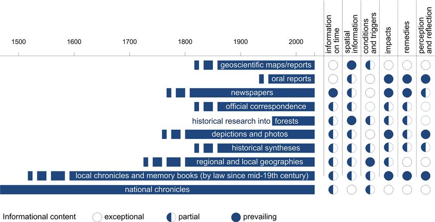
2584                                                            M. Bíl et al.: CHILDA – Czech Historical Landslide Database

Figure 2. An overview of available documentary data applicable for historical landslide research in Czechia with respect to their time
coverage and informational content.

landslide hazards (Krejčí et al., 2017) and which explored          while some were found in private collections. The primary
the availability of documentary sources (Kozák and Rybář,           documentary data were also complemented by a search in
2003).                                                               secondary (published) literature (e.g. newspapers, historical
                                                                     synthesis, historical research into forests) and in some areas
                                                                     also with oral inquiry. Within the data search, the lower time
3     Design of the CHILDA database                                  boundary for the database has not been set. The upper (re-
                                                                     cent) boundary, for the aim of the analysis in this work, was
3.1    Data availability
                                                                     set at 1989. We have allowed, however, the database to re-
Czechia has at its disposition an extremely diverse and exten-       main open in order to allow users to add new landslides as
sive range of documentary data that may be explored to build         well.
historical landslide inventories. The number of these sources
                                                                     3.2   Database structure
have been, however, subjected to academic scrutiny mostly in
historical climatology and hydrology (Kjeldsen et al., 2014;         The database structure reflects the specific nature of doc-
Brázdil et al., 2018a). Similarly, Bíl et al. (2020) combined        umentary data, which usually do not allow to distinguish
different documentary and archaeological data to compile a           details of movement types, magnitudes, or velocities. For
chronology of landsliding in the Pavlovské vrchy (Czechia,           the individual attributes, we considered the existing classi-
OWC) and described the basic historical landslide terminol-          fications of movement types (Hungr et al., 2014), tempo-
ogy. The conceptual differences in hydrometeorological and           ral dimensions of landsliding (Flageollet 1996), and land-
geomorphologic hazards do not allow for uncritical transpo-          slide impacts (Alimohammadlou et al., 2013), and where
sition of the climatological insights into the historical land-      possible, the attributes were designed to allow comparabil-
slide research and therefore call for new insights into the po-      ity with these classification schemes. Attributes related to
tential of the documentary data (Crozier and Glade, 1999;            each database record are presented in Table 1. Some of the
Raška et al., 2014b).                                                attributes are added by users via a form. The items with an
   The present landslide database is based on a systematic           asterisk are mandatory and the items which are not part of the
data search in documentary data (both written and icono-             input form are underlined. They are processed automatically,
graphic) of several types with varying content, coverage, and        within the system.
availability. All the data used along with their characteris-
tics are shown in Fig. 2. Most of these data are available in
local archives in a printed or handwritten form (e.g. munic-
ipal and school chronicles, official correspondence, photos),

Nat. Hazards Earth Syst. Sci., 21, 2581–2596, 2021                                   https://doi.org/10.5194/nhess-21-2581-2021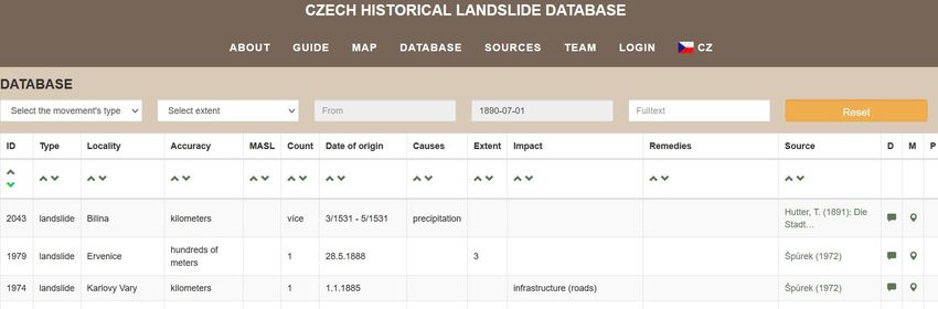
M. Bíl et al.: CHILDA – Czech Historical Landslide Database 2585
Table 1. Structure of records in CHILDA.
Field name∗ Description Field type
ID Unique identifier of a landslide Number
Type∗ Determination of kind of landsliding List: landslide; rockfall; earthflow; debris flow; human-
induced landslide
Position∗ Latitude and longitude of the record inserted via a click on WGS 84 coordinates
the map
Locality∗ Description of the locality String
Accuracy∗ Describes the spatial precision of landslide localisation by List: metres; tens of metres; hundreds of metres; kilometres
DB (database) user (not a precision in an original source)
MASL Height above mean sea level – Metres
landslide highest point elevation
Count The number of landslides related to the particular location, String
given its accuracy; default value 1
Start∗ The earliest possible date for the beginning of landsliding Date
indicated by a record
End∗ The latest possible date for the beginning of landsliding as Date
indicated by a record
Period Shows an interval during which the landslide originated. It String; an exact day or and interval, e.g. September 1941–
is computed as End–Start. May 1942
Causes Description of landslide cause; more causes can be selected List: earthquake; lithology; flooding; precipitation; mining;
snow thaw; storm; artificial cause
Extent Extent of landsliding List: small: less than 100 m2 , volume up to 100 m3 ;
medium: up to 1 ha, volume up to 1000 m3 ; large: more than
1 ha, volumes larger than 1000 m3
Impact List of elements at risk and losses caused by landsliding; List: human fatality; human injury; buildings; transport in-
more impacts can be selected frastructure; other infrastructure (mine, water tower, utili-
ties, etc.); landscape including old mines, etc.
Remedies Kind of remediation if applied String
Source∗ Full citation of the source of the landslide record String
Details Additional information and original data availability and ac- String
cessibility (e.g. museum, archive, private collection)
Notes Other relevant information about landsliding String
Photo More than one graphics file can be attributed to a record, Graphics file, pdf
e.g. photo, map, a copy of a written source
∗ Mandatory attributes.
Note: the attributes which are bold are automatically added by the system and are not part of the user form for data entering.
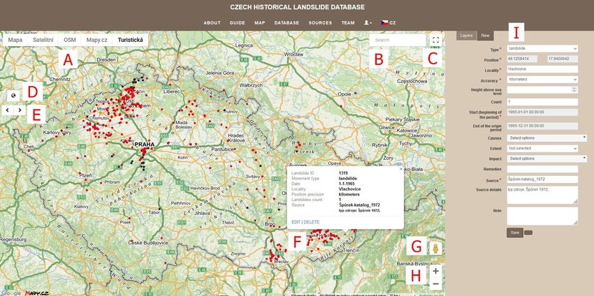
3.3 Web-map application CHILDA users can select a background map (see Fig. 4,
A). There are the following possibilities: base map, or-
The database can be accessed through a web-map application thophoto, Open Street Map, Mapy.cz map, and a hiking map.
at https://childa.cz/ (last access: 19 August 2021) (Fig. 3). A municipality or other geographical feature with a conven-
CHILDA is administrated and hosted on the CDV – Trans- tional name (mountains, etc.) can be selected via a form (B).
port Research Centre servers. The software requirement is The full-screen mode is launched when a user clicks on the
as follows: PostgreSql/PostGIS, php, php NetteFramework, icon (C). Standard map control features such as full extent
HTML, CSS, JQuery. (D), backward and forward screen (E), Google Street View
(G), and zoom in/out (H) are also available here. A detailed
landslide description is shown in the pop-up window after
https://doi.org/10.5194/nhess-21-2581-2021 Nat. Hazards Earth Syst. Sci., 21, 2581–2596, 2021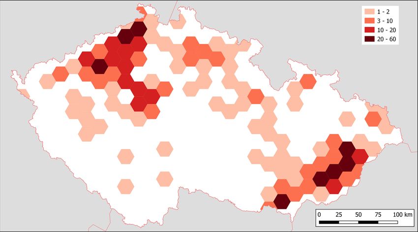
2586                                                               M. Bíl et al.: CHILDA – Czech Historical Landslide Database

Figure 3. Title page of CHILDA (https://childa.cz/?lang=en, last access: 19 August 2021).

Figure 4. Additional information on a landslide record can be obtained after clicking on a point in the map view. A new landslide can be added
through the form (right side). A – background map; B – municipality; C – full-screen mode; D – full extent control; E – backward/forward
screen; F – landslide description; G – Google Street View; H – zoom in/out; I – new landslide button. ©Mapy.cz.

clicking on the landslide map symbol (F). A new landslide                pop-up window in the map or in the database after log in.
record can be added through a form (I). This panel contains              There is currently no automatic validation of data entered by
two bookmarks. In the Layer, the symbology and the time fil-             users to have the app as accessible and user friendly as pos-
ter can be seen. In New, a new landslide record can be added             sible. Three roles of users are defined: non-registered users,
or an existing one can be edited. Only registered users can              registered users (who are allowed to edit, delete their own
edit their own landslides. The edit button is visible in the             data), and administrators (editing, deleting all data).

Nat. Hazards Earth Syst. Sci., 21, 2581–2596, 2021                                        https://doi.org/10.5194/nhess-21-2581-2021
M. Bíl et al.: CHILDA – Czech Historical Landslide Database                                                                          2587

Figure 5. A database table visualises information on landslides and allows for filtering data according to a number of parameters.

Table 2. Database completeness on the basis of particular non-           tres (mostly between 1–2 km, exceptionally up to 5 km in the
mandatory fields.                                                        mountain terrains of Czechia).
                                                                            Table 2 presents database completeness that was deter-
       Filed name        Number              Relative                    mined based on several non-mandatory fields (cause of land-
                         of records          number [%]                  sliding, extent, impact, etc.). The relative number [%] of par-
       Cause of          120                 17.2                        ticular fields always refers to all records in CHILDA (i.e.
       landsliding                                                       a proportion of 100 %). The average number of database
       Extent            181                 25.9                        completeness amounted to 33 %. An increase, however, in
       Impact            354                 50.6                        database completeness in the next years, based on the incor-
       Remedies          38                  5.4                         poration of new results arising from future research, is as-
       Source details    645                 92.3                        sumed.
       Photo             53                  7.6                            Our data can also be compared to the previous land-
                                                                         slide chronology compiled by Špůrek (1972) for the area of
                                                                         Czechia. Špůrek’s last data on landsliding come from 1970.
    The landslide database is also accessible via a table                Our comparison consequently also ends this year. As for
(Fig. 5). Three filters are available: (i) movement type, (ii)           1970, CHILDA currently (April 2021) contains 667 records.
extent, and (iii) time period. Full text searching is also possi-        In total, 359 of these records were also part of Špůrek’s
ble. The given filter is kept when the map is selected unless            overview. This indicates that our new investigation consti-
it is reset by the user.                                                 tutes almost 50 % of new records in the database, i.e. records,
                                                                         which were not previously covered by Špůrek’s catalogue.
                                                                         A major source of Špůrek’s information about landsliding
                                                                         was newspapers. However, apart from newspapers, in our re-
4     Results
                                                                         search, we also focused on the primary documentary data
                                                                         available in archives (e.g. chronicles, memory books, offi-
4.1    Landslide records in CHILDA
                                                                         cial correspondence). This approach has huge potential for
                                                                         revealing new and unique past landslide events during the
We present below an overview of data contained in CHILDA
                                                                         ongoing research.
for the 1132–1989 period. The database contains 699
                                                                            As Fig. 6 indicates, the highest density of historical land-
records, 619 of them categorised as landslides, 75 as rock-
                                                                         slide records in Czechia in the studied period concentrates
falls, and 5 as “other” kind of mass movements (earth flow,
                                                                         on three primary landslide areas (OWC, CS, DV). Tens of
rockslide, or human-induced landslide). As regards tempo-
                                                                         landslide records come, however, from the area of the cap-
ral accuracy (see Table 1 for explanation), 231 records were
                                                                         ital, Prague (VR) represented mainly by rockfalls. A higher
determined exactly at single-day precision, 17 records are
                                                                         occurrence of records is also typical for Bohemian Paradise
known with a weekly and 88 with a monthly precision. In
                                                                         sandstones (BP).
total, 363 records were only attributed to a given year. Con-
                                                                            While landslide records come from all three core landslide
cerning the location accuracy, 111 records were localised
                                                                         areas, the rockfall records were typical for the west part of
precisely, 71 records with a precision of “tens of metres”,
260 records to “hundreds of metres”, and 478 to kilome-

https://doi.org/10.5194/nhess-21-2581-2021                                      Nat. Hazards Earth Syst. Sci., 21, 2581–2596, 2021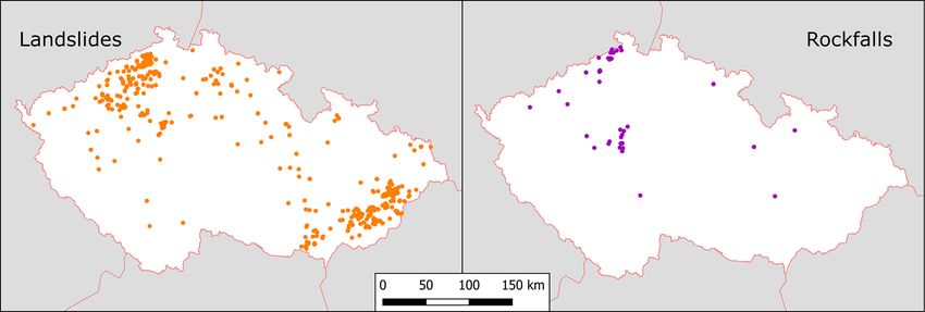
2588                                                          M. Bíl et al.: CHILDA – Czech Historical Landslide Database

Figure 6. Landslide density across Czechia.

Figure 7. Landslide and rockfall distribution.

Czechia (DV area) and along the Vltava/Moldau river valley        ing in 1761. The records in the period 1761–1989 represent
(VR) south of Prague (Fig. 7).                                    98 % of all records in CHILDA (Fig. 8). The highest numbers
   The temporal variability of the landslide records, repre-      of records were registered during the decade of 1891–1900
sented by their numbers within centuries in the whole stud-       (19 %) followed by the decades of 1931–1940 (14 %) and
ied period, is shown in Table 3. The only one (and at the         1961–1970 (14 %). No records were detected, however, be-
same time the oldest) record is known from the twelfth cen-       tween 1791–1810. A significant rise in the number of records
tury (19 January 1132, see Sect. 4.2). No reports were de-        is apparent from the decade of 1891–1900 onwards and the
tected between the thirteenth and fifteenth centuries, and only   course over the rest of the twentieth century is more or less
five and two reports were recorded in the sixteenth and sev-      variable. The variability has been in all probability influenced
enteenth centuries, respectively. While only 8 records were       by important rainfall and/or snow thaw events.
found between the twelfth and seventeenth centuries and 30           The earliest important landslide year occurred in 1770. A
records in the eighteenth century, the majority of the records    minimal number of landslide records to determine a partic-
are evidenced in the last 2 centuries. Landslide records cov-     ular year as the most important landslide year was set at 10
ering the nineteenth century account for 27.8 %, whereas          reports. From 1770, 15 such years were revealed encompass-
records from the twentieth century encompass 66.8 % of all        ing 55 % of all records on mass movements (385 out of 699)
reports.                                                          (Table 4). The highest number of landslide records was found
   Due to a rapid increase in landslide records after 1770,       in 1900 (61), 1941 (51), and 1939 (46), representing 15.8 %,
a decadal frequency of landslide records was created start-

Nat. Hazards Earth Syst. Sci., 21, 2581–2596, 2021                               https://doi.org/10.5194/nhess-21-2581-2021
M. Bíl et al.: CHILDA – Czech Historical Landslide Database                                                                       2589

Table 3. The number of landslide records within centuries in Czechia between the twelfth and twentieth centuries.

                              Century       12th      13th   14th   15th   16th   17th   18th   19th   20th∗
                              n             1         0      0      0      5      2      30     194    467
                            ∗ up to and including 1989.

Figure 8. Decadal frequency of landslide records in Czechia between 1761–1989.

13.2, and 11.9 % of the most important 15 landslide years,                    The oldest known written report describes a rock-
respectively.                                                              fall in Prague–Chuchle (VR area) on 19 January 1132
                                                                           (Strnad, 1790). More detailed information about three land-
4.2   The oldest records on landsliding                                    slide events in spring 1531 is described by chroniclers from
                                                                           Litoměřice and Bílina (CS area). Landsliding was reported
The issue of the precise determination of dates of landslide               from the beginning of April until the middle of May and
activity becomes more important when we look back in his-                  affected Radobýl Hill near Litomeřice and Holý vrch near
tory. The oldest records describing landslides in Czechia suf-             Zahořany village. Vineyards planted on the hills and slopes
fer from spatiotemporal inhomogeneity. CHILDA currently                    slid and two great parts of Radobýl Hill slipped down, in-
contains 14 reports of mass movements which took place be-                 cluding trees and plants. Similarly, a large portion of Holý
fore 1770, the first most important landslide year (see Ta-                vrch slid at that time and a series of other landslides were
ble 4). It is important to mention that in 50 % of all recorded            observed (Smetana, 1978). In the wet spring of 1531, several
cases, citations referring to historical landslides in this study          landslides also occurred in the surroundings of the nearby
came from the Špůrek landslide catalogue (1972). Because of               Bílina River after a flood (Hutter, 1891).
our efforts at maximum authenticity, we took over these ci-                   A day before Christmas Eve of 1595 a landslide occurred
tations although we were not able to study some referenced                 near Vraclav–Domoradice village (Špůrek, 1967). Accord-
citations personally in certain cases.                                     ing to Kárník et al. (1957), seismic activity preceded this
                                                                           event. In March 1599, extraordinary damage was described

https://doi.org/10.5194/nhess-21-2581-2021                                        Nat. Hazards Earth Syst. Sci., 21, 2581–2596, 2021
2590 M. Bíl et al.: CHILDA – Czech Historical Landslide Database
Table 4. The most important 15 landslide years (1770–1989) when at least 10 records were found.
Year 1770 1898 1899 1900 1915 1919 1926 1937
n 17 39 13 61 10 10 32 10
Year 1938 1939 1940 1941 1965 1967 1970
n 11 46 19 51 38 14 14
in Litoměřice (CS area) as a consequence of a great deal of of recorded events over time. First, the sole oldest record
snow and wet weather (Brázdil et al., 2013.b). The chronicler dated to 1132 extends the span by 4 centuries as further
described the situation as follows: “A piece of town wall near records are only dated to 1531. Second, the majority of
St. Laurentius [church] fell and collapsed ... On 16 March ... records (93 %) relates landsliding that occurred since 1850.
at the cemetery ... a huge section slipped down too so the In contrast, and unlike the other databases, CHILDA also
graves opened and the dead bodies were thrown out .... That records only a few increased landslide frequencies in the pre-
same year, in the month of March, extensive damage to vine- industrial periods, namely the 1770 landslide year (17 land-
yards was experienced by many [people], the walls caved slides) resulting from the central European adverse climate
in and one vineyard after another slid and all of this was (Raška et al., 2016) and 1817 (with five landslides) possibly
happening due to great wetness”. In addition, a number of influenced by the Tambora eruption in 1815 (Brázdil et al.,
springs appeared on the surface, the cellars were full of wa- 2016b).
ter which had to be pumped out, and one house even slipped
away (Smetana, 1978). 5.2 Limitations of the CHILDA database
The oldest landslide report from OWC, based on a writ-
ten record, occurred in the Pavlovské vrchy in Pavlov village
As with similar databases which focus on historical records
in 1663 (Maca, 1994; Kryčer). In contrast to previous mass
and therefore depend on availability, accessibility, and reli-
movement events, continuing landsliding was also recorded
ability of original sources, CHILDA also has certain limita-
on the same street in 1667 (Štefková-Vajayová, 2001), 1715,
tions that may be grouped in the following kinds of uncer-
1730, and 1763 (Maca, 1994; Kryčer). A detailed description
tainties.
of landslide damage before 1763 is missing, but the particu-
(a) Uncertainty is usually related to a description of events
lar landslide consequences in the area of the Pavlovské vrchy
as landslides (mass movements in general) in the documen-
in the following years were described by Bíl et al. (2020).
tary records which were named differently. The termino-
A brief report of landslide occurrence comes from Dečín–
logical inconsistency, closely connected with exploiting the
Chrochvice (DV area) in 1736 (Mauder, 1931). This event
wide range of documentary data, lasted at least until the
was the first one from a series of consequent landslides in
twentieth century and persists in media reports up until re-
1823, 1850, and 1914 which affected an area of 16 ha and
cent days. This inconsistency was caused by gaps in scien-
damaged buildings and local infrastructure (Špůrek, 1972).
tific knowledge in the first Czech modern landslide classi-
A similar lack of information relates to a landslide in Ústí
fication published in 1954 (Záruba and Mencl, 1954; com-
nad Labem (DV area) in 1767 (Špůrek, 1972). In contrast the
pared with much earlier attempts in English listed in Cruden,
collapse of a parish cellar in Líbeznice village in 1769 is rel-
2003) and by cultural and resulting language diversity in the
atively well described by Třebízský (1885), who mentioned
Czech Lands up until 1945 (i.e. Czech and German culture
great wetness and surfeit of water this year.
realms). Raška et al. (2015) analysed historical landslides in
two Czech regions and found seven different terms referring
5 Discussion to landslides and three for rockfalls. In total, five German
different terms were used to describe the landslides in the
5.1 CHILDA and other historical landslide databases Pavlovské vrchy (OWC) between the middle of the seven-
teenth to the twentieth centuries (Bíl et al., 2020).
We presented an overview of the CHILDA database where (b) Moreover, documentary evidence was not continuous,
as many as possible records on historical landsliding, which sometimes only depending on concrete persons. Chroniclers
took part in the area of modern Czechia, were collected. This were often not interested in this phenomenon as there were
database currently contains 699 records (between 1132 and more dangerous ones in this area, such as floods (Brázdil
1989) and can be compared to other similar databases which et al., 2011; Elleder et al., 2020), strong winds (Brázdil et al.,
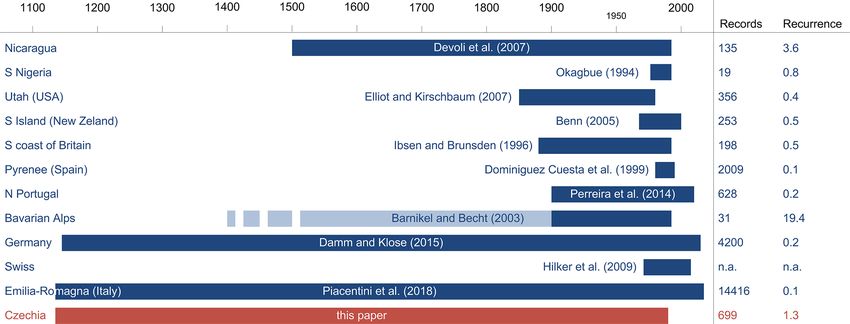
have been completed in other countries (Fig. 9). 2004, 2017, 2018b), and episodes of drought (Brázdil et al.,
It should be noted, however, that similarly to other 2013a; Dolák et al., 2015; Řezníčková et al., 2015; Brázdil
databases CHILDA displays high asymmetry in the number et al., 2016a, 2019). There is obviously also a significant
Nat. Hazards Earth Syst. Sci., 21, 2581–2596, 2021 https://doi.org/10.5194/nhess-21-2581-2021M. Bíl et al.: CHILDA – Czech Historical Landslide Database 2591 Figure 9. Comparison of CHILDA and other existing historical landslide databases in terms of the number of records and recurrence. Note: dark-blue stripes mark the periods under study. In the case of compound (multi-hazard) databases, light-blue marks complete the studied period for which geohazards other than landslides have been found, whereas dark-blue stands for landsliding. Dashed stripes represent an unspecified beginning (e.g. since the fifteenth century without explicit dating of the oldest record). growth of available sources especially since the nineteenth data reliability based on comparison among more sources or century, which may distort the represented landslide frequen- field research is not always possible and reliable, and there- cies over time. The availability of sources also displays a dis- fore any database must always be considered a catalogue of tinct geographical variation due to different historical devel- records rather than events themselves. In the case of the cat- opments in individual regions. Several smaller uncertainties alogue of event utilisation, these uncertainties relate to, e.g., related to historical landslides have thus appeared, e.g. a lack the example of 12 records in CHILDA that describe more of narrative sources before 1920 and in the Czech border ar- than one event, but the real number is not known. Such events eas after 1945 (Bíl et al., 2020) or difficulties with recog- could therefore present events with higher intensities than nition of landslides and scoured slopes during the floods in other events where only single landslides were reported. early documentary records. As regards the Czech border ar- In addition, any quantification of landslide extents and eas, chronicles were lost or carried away mainly by German their impact is also complicated. We therefore decided to inhabitants displaced after 1945. This occurred, along with only select from a few attributes generally describing im- other regions, in the landslide-prone areas of the Pavlovské pacts. Reactivations of landslide at the same place could also vrchy or parts of NW Czechia (CS and DV). Only some of not be determined exactly. Sometimes, as documented in Bíl the lost information from the chronicles became available et al. (2014) from the village of Halenkovice, villagers from again via a historical synthesis published in the second half of landslide-prone areas were used to seeing the landslides often the twentieth century (Bíl et al., 2020). In addition, keeping and as a result did not pay attention to them. In contrast, rare memory books was recommended by the state in 1836 and landsliding in other areas attracted the attention of the locals. chronicles were made mandatory from 1920 onward; there- Construction work, related to the first railways across OWC, fore any older events are either missing in these sources or also both found and caused some landslides (e.g. Záruba, were recorded retrospectively with some risk of misinterpre- 1938). The apparent lack of documented landslides before tation. 1920 in the Carpathians (except for the Pavlovské vrchy) (c) Additional problems include uncertainties resulting was attributed by Bíl et al. (2014) to dispersed settlements from difficult to identify duplicities in records of different built primarily from wood, the majority of unpaved roads, coverage (i.e. the issue of upscaling and downscaling) and and relatively sparse inhabitation in the area. Limited spatial from false frequency peaks caused by a combination of con- accuracies of historical records often influence any reliable tinual (regularly published) and stationary (published once as evaluation regarding the possible structural or anthropogenic a collection of records) data (Raška et al., 2014b). Both these triggers. issues may result in false peaks and gaps in the landslide Despite all these uncertainties, documentary evidence time series. Also, it cannot be ruled out that certain records stands as a valuable and indispensable source of data de- on landsliding in the past, albeit once existing, were sub- scribing the occurrence and the consequences of landslides sequently lost. Verification of data through checking of the in Czechia during the last 5 centuries. https://doi.org/10.5194/nhess-21-2581-2021 Nat. Hazards Earth Syst. Sci., 21, 2581–2596, 2021
2592                                                             M. Bíl et al.: CHILDA – Czech Historical Landslide Database

5.3    Further applications and development of the                   Data availability. Data are available for free via the CHILDA web-
       database                                                      site (https://childa.cz; CHILDA, 2021) in the form of a table and
                                                                     map. The website also includes guidelines for data use and refer-
Data currently contained in CHILDA can be further anal-              encing.
ysed in order to delineate and explain their temporal and
spatial concentration. While the spatial extent of landsliding
can easily be understood as an apparent relation to lithol-          Author contributions. MB, PR and LD collaborated on the concep-
ogy, temporal distribution has been influenced by important          tualisation of the study and empirical research; JK programmed the
rainfall and/or snow thaw events. Information on landslides          CHILDA and processed landslide data. All authors assisted with
                                                                     writing the draft and the final version of the manuscript.
with known dates of activities, which is the case for CHILDA
records, can therefore be used in such a determination of re-
gional rainfall or total water content triggers. Bíl et al. (2016)
                                                                     Competing interests. The authors declare that they have no conflict
have, for example, already utilised the information on land-
                                                                     of interest.
slide periods, defined for an area in the central part of OWC,
to determine rainfall thresholds for this area. Further appli-
cations of the data will include analyses of the long-term           Disclaimer. Publisher’s note: Copernicus Publications remains
changes in landslide risk reduction approaches, their effec-         neutral with regard to jurisdictional claims in published maps and
tiveness, and efficiency (Caloireo et al., 2014; Klose et al.,       institutional affiliations.
2016) framed by disaster risk reduction strategies (DRR)
(Bíl et al., 2014; UNDRR, 2015). Analysis of community
responses to landslide risk in individual landslide-prone ar-        Acknowledgements. Thanks go to Vojtěch Cícha for help with the
eas has already been published by Raška (2019) and Klimeš            preparation of figures, Vilém Zábranský and Jiří Riezner for sug-
et al. (2020) and allowed for an exploration of both formal          gesting new data sources that included records on landsliding, and
(planning, DRR administration) and informal (community               David Livingstone for assistance with language editing.
help, mobilisation of local knowledge) mechanisms in land-
slide risk reduction.
                                                                     Financial support. Michal Bíl and Jan Kubeček worked with the
                                                                     financial support of the Ministry of Transport of the Czech Re-
6     Conclusions                                                    public within the programme of long-term conceptual develop-
                                                                     ment of research institutions. Pavel Raska was supported by
We presented the online landslide database CHILDA (Czech             the project Smart City – Smart Region – Smart Community
Historical Landslide Database), which summarises informa-            (CZ.02.1.01/0.0/0.0/17_048/0007435) within the Operational Pro-
tion about landslides which took place in the area of Czechia        gram Research, Development and Education of the Czech Repub-
(the Czech Republic). The database is freely accessible via          lic. Lukáš Dolák was supported by SustES – Adaptation strategies
                                                                     for sustainable ecosystem services and food security under adverse
the http://childa.cz/ (last access: 19 August 2021) website
                                                                     environmental conditions (CZ.02.1.01/0.0/0.0/16_019/0000797).
and currently includes 699 records (spanning the 1132–1989
period). The oldest record relates to a rockfall which took
place in 1132. In total, the database doubled the number             Review statement. This paper was edited by Paola Reichenbach
of records known from the previous historical database in            and reviewed by two anonymous referees.
Czechia. We further described in detail another eight of the
oldest records (1531 to 1730) and analysed centennial and
decadal frequencies of landslide records. It was demonstrated
that 55 % of all recorded landslide events occurred only
within 15 years of the extreme landslide incidence. Finally,         References
the limitations of the documentary data sources have been
                                                                     Alimohammadlou, Y., Najafi, A., and Yalcin, A. Landslide process
summarised pointing at uncertainties within the database.
                                                                        and impacts: A proposed classification method. CATENA, 104,
The future research direction should focus on analysing his-            219–232, https://doi.org/10.1016/j.catena.2012.11.013, 2013.
torical landslide triggers and their thresholds, on changes in       Bíl, M. and Müller, I.: The origin of shallow landslides in Moravia
spatiotemporal patterns of landslide impacts on society, and            (Czech Republic) in the spring of 2006, Geomorphology,
on narratives of societal adaptive management to landslide              99, 246–253, https://doi.org/10.1016/j.geomorph.2007.11.004,
risk.                                                                   2008.
                                                                     Bíl, M., Krejčí, O., Bílová, M., Kubeček, J., Sedoník, J., and Kre-
                                                                        jčí, V.: A Chronology of landsliding and its impactss on the vil-
                                                                        lage of Halenkovice, Outer Western Carpathians, Geografie, 119,
                                                                        342–363,       https://doi.org/10.37040/geografie2014119040342,
                                                                        2014.

Nat. Hazards Earth Syst. Sci., 21, 2581–2596, 2021                                    https://doi.org/10.5194/nhess-21-2581-2021
M. Bíl et al.: CHILDA – Czech Historical Landslide Database 2593 Bíl, M., Andrášik, R., Zahradníček, P., Kubeček, J., Sedoník, J., the Czech Lands in the pre-instrumental period, Clim. Past, 15, and Štěpánek, P.: Total water content thresholds for shallow 124, https://doi.org/10.5194/cp-15-1-2019, 2019. landslides, Outer Western Carpathians, Landslides, 13, 337–347, Burda, J., Hartvich, F., Valenta, J., Smítka, V., and Rybář, J.: https://doi.org/10.1007/s10346-015-0570-9, 2016. Climate-induced landslide reactivation at the edge of the Bíl, M., Andrášik, R., Kubeček, J., Křivánková, Z., and Vodák, R.: Most Basin (Czech Republic) – progress towards better land- RUPOK: An Online Landslide Risk Tool for Road Networks, slide prediction, Nat. Hazards Earth Syst. Sci., 13, 361–374, Advancing Culture of Living with Landslides, Vol 5: Landslides https://doi.org/10.5194/nhess-13-361-2013, 2013. in Different Environments, edited by: Mikoš, M., Vilímek, V., Cajz, V.: The České středohoří Mts.: volcanostratigraphy and geo- Yin, Y., and Sassa, K., Springer International Publishing Ag, chemistry, Geolines, 9, 21–28, 1999. Cham, 19–26 pp., 2017. Caloiero, T., Pasqua, A. A., and Petrucci, O.: Damaging Hydro- Bíl, M., Krejčí, O., Dolák, L., Krejčí, V., Martínek, J., and geological Events: A Procedure for the Assessment of Severity Svoboda, J.: A chronology of landsliding based on ar- Levels and an Application to Calabria (Southern Italy), Water, 6, chaeological and documentary data: Pavlovské vrchy Hills, 3652–3670, https://doi.org/10.3390/w6123652 2014. Western Carpathian Flysch Belt, Sci. Rep.-UK, 10, 976, Caracciolo, D., Arnone, E., Conti, F. L., and Noto, L. V.: Exploiting https://doi.org/10.1038/s41598-020-57551-4, 2020. historical rainfall and landslide data in a spatial database for the Brázdil, R., Dobrovolný, P., Štekl, J., Kotyza, O., Valášek, H., and derivation of critical rainfall thresholds, Environ. Earth Sci.,76, Jež, J.: History of weather and climate in the Czech Lands. VI, 222, https://doi.org/10.1007/s12665-017-6545-5 2017. Strong winds, 1st published edn., History of Weather and Cli- Crozier, M. J. and Glade, T.: Frequency and magnitude of landslid- mate in the Czech Lands, Masaryk University, Brno, 377 pp., ing: Fundamental research issues, Z. Geomorphol. Supp., 115, 2004. 141–155, https://doi.org/10.1127/zfgsuppl/115/1999/141, 1999. Brázdil, R., Řezníčková, L., Valášek, H., Havlíček, M., Dobro- Cruden, D. M.: The First Classification of Landslides?, En- volný, P., Soukalová, E., Řehánek, T., and Skokanová, H.: vironmental and Engineering Geoscience, 9, 197–200, Fluctuations of floods of the River Morava (Czech Re- https://doi.org/10.2113/9.3.197, 2003. public) in the 1691–2009 period: interactions of natural Čermák, J.: Sesutí stráně a hrazené jezero u Mladotic: předběžná and anthropogenic factors, Hydrolog. Sci. J., 56, 468–485, zpráva [Landslide and the landslide-dammed lake of Mladotice: https://doi.org/10.1080/02626667.2011.564175, 2011. a preliminary report], Sborník České společnosti zeměvědné, 18, Brázdil, R., Dobrovolný, P., Trnka, M., Kotyza, O., Řezníčková, L., 19–23, 1912. Valášek, H., Zahrádníček, P., and Štěpánek, P.: Droughts in CHILDA – Czech Historical Landslide Database: available at: the Czech Lands, 1090–2012 AD, Clim. Past, 9, 1985–2002, https://childa.cz, last access: 9 April 2021. https://doi.org/10.5194/cp-9-1985-2013, 2013a. CHMI – Czech Hydrometeorological Institute: available at: http: Brázdil, R., Kotyza, O., Dobrovolný, P., Řezníčková, L., and //www.chmi.cz, last access: 9 April 2021. Valášek, H.: Climate of the Sixteenth Century in the Czech Czech Geological Survey: available at: http://www.geology.cz (last Lands, History of Weather and Climate in the Czech Lands, access: 8 February 2021), 2012a. Masaryk University, Brno, 286 pp., 2013b. Czech Geological Survey Map Server: available at: Brázdil, R., Raška, P., Trnka, M., Zahradníček, P., Valášek, H., Do- https://mapy.geology.cz/arcgis/rest/services/Inspire/GM2_ brovolný, P., Řezníčková, L., Treml, P., and Stachoň, Z.: The 5mil/MapServer?f=jsapi (last access: 5 March 2021), 2012b. Central European drought of 1947: causes and consequences, Damm, B. and Klose, M.: The landslide database for Germany: with particular reference to the Czech Lands, Clim. Res., 70, Closing the gap at national level, Geomorphology, 249, 82–93, 161–178, https://doi.org/10.3354/cr01387, 2016a. https://doi.org/10.1016/j.geomorph.2015.03.021, 2015. Brázdil, R., Řezníčková, L., Valášek, H., Dolák, L., and Ko- Dědina, V.: Sesouvání stráně na Chlomku u Ml. Boleslavě [Land- tyza, O.: Climatic effects and impacts of the 1815 eruption of sliding at Chloumek by Ml. Boleslav town], Sborník České Mount Tambora in the Czech Lands, Clim. Past, 12, 1361–1374, společnosti zeměvědné, 2, 40–41, 1896. https://doi.org/10.5194/cp-12-1361-2016, 2016b. Dědina, V.: Sesutí půdy pod Chlomkem u Ml. Boleslavi [Land- Brázdil, R., Szabó, P., Dobrovolný, P., Řezníčková, L., Kotyza, O., slide of earth at Chloumek by Ml. Boleslav town], Sborník České Suchánková, S., and Valášek, H.: Windstorm of the eighteenth společnosti zeměvědné, 22, 160–166, 1916. century in the Czech Lands: course, extent, impacts, Theor. Devoli, G., Morales, A., and Høeg, K.: Historical landslides in Appl. Climatol., 129, 623–632, https://doi.org/10.1007/s00704- Nicaragua – collection and analysis of data, Landslides, 4, 5–18, 016-1806-x, 2017. https://doi.org/10.1007/s10346-006-0048-x, 2007. Brázdil, R., Kiss, A., Luterbacher, J., Nash, D. J., and Dolák, L., Brázdil, R., Řezníčková, L., and Valášek, H.: Se- Řezníčková, L.: Documentary data and the study of past lected drought impacts in South Moravia in the 18th and 20th droughts: a global state of the art, Clim. Past, 14, 1915–1960, centuries based on documentary evidence, In: Otmar Urban, https://doi.org/10.5194/cp-14-1915-2018, 2018a. Mirka Šprtová, Karel Klem. Global Change: A Complex Chal- Brázdil, R., Stucki, P., Szabó, P., Řezníčková, L., Dolák, L., lenge. Conference Proceedings. Global Change Research Cen- Dobrovolný, P., Tolasz, R., Kotyza, O., Chromá, K., and tre, The Czech Academy of Sciences, v.v.i., Brno, 30–33 pp., Suchánková, S.: Windstorms and forest disturbances in the 23–24 March 2015, 2015. Czech Lands: 1801–2015, Agr. Forest Meteorol., 250, 47–63, Elleder, L., Krejčí, J., Racko, S., Daňhelka, J., Šírová, J., and https://doi.org/10.1016/j.agrformet.2017.11.036, 2018b. Kašpárek, L.: Reliability check of flash-flood in Central Bo- Brázdil, R., Dobrovolný, P., Trnka, M., Řezníčková, L., Dolák, L., hemia on 25 May 1872, Global Planet. Change, 187, 103094, and Kotyza, O.: Extreme droughts and human responses to them: https://doi.org/10.1016/j.gloplacha.2019.103094, 2020. https://doi.org/10.5194/nhess-21-2581-2021 Nat. Hazards Earth Syst. Sci., 21, 2581–2596, 2021
2594                                                                  M. Bíl et al.: CHILDA – Czech Historical Landslide Database

Elliott, A. and Kirschbaum, M.: The preliminary landslide history         Kalvoda, J. and Balatka, B.: Chronodynamics of the Labe River an-
   database of Utah, 1850–1978, Utah Geological Survey, 514, 5,             tecedence in the Děčínská vrchovina Highland, Czech Republic,
   2007.                                                                    Acta Montana IRSM AS CR Series A, 8, 43–60, 1995.
Forczek, I.: Destruction of marginal parts of sandstone plateaus in       Kárník, V., Michal, E., and Molnár, A.: Erdbebenkatalog der Tsche-
   the protected landscape area Bohemian Paradise, Acta Geodyn.             choslowakei bis zum Jahre 1956, Travaux Géophysiques, 69,
   Geomater., 5, 267–274, 2008.                                             411–598, 1957.
Froude, M. J. and Petley, D. N.: Global fatal landslide occurrence        Kjeldsen, T. R., Macdonald, N., Lang, M., Mediero, L., Al-
   from 2004 to 2016, Nat. Hazards Earth Syst. Sci., 18, 2161–2181,         buquerque, T., Bogdanowicz, E., Brázdil, R., Castellarin, A.,
   https://doi.org/10.5194/nhess-18-2161-2018, 2018.                        David, V., Fleig, A., Gul, G. O., Kriauciuniene, J., Kohnová, S.,
Flageollet, J.-C.: The time dimension in the study of                       Merz, B., Nicholson, O., Roald, L. A., Salinas, J. L.,
   mass      movements.        Geomorphology,        15,     185–190,       Sarauskiene, D., Šraj, M., Strupczewski, W., Szolgay, J.,
   https://doi.org/10.1016/0169-555X(95)00069-H, 1996.                      Toumazis, A., Vanneuville, W., Veijalainen, N., and Wilson, D.:
Gariano, S. L. and Guzzetti, F.: Landslides in a                            Documentary evidence of past floods in Europe and their util-
   changing climate, Earth-Sci. Rev., 162, 227–252,                         ity in flood frequency estimation, J. Hydrol., 517, 963–973,
   https://doi.org/10.1016/j.earscirev.2016.08.011, 2016.                   https://doi.org/10.1016/j.jhydrol.2014.06.038, 2014.
Glade, T., Albini, P., and Frances, F.: An introduction to the use        Klimeš, J., Stemberk, J., Blahut, J., Krejčí, V., Krejčí, O.,
   of historical data in natural hazard assessments, Use of Histor-         Hartvich, F., and Kycl, P.: Challenges for landslide hazard
   ical Data in Natural Hazard Assessments, edited by: Glade, T.,           and risk management in “low-risk” regions, Czech Republic-
   Albini, P., and Frances, F., Springer, Dordrecht, 2001.                  landslide occurrences and related costs (IPL project no. 197),
Guzzetti, F., Cardinali, M., and Reichenbach, P.: The AVI                   Landslides, 14, 771–780, https://doi.org/10.1007/s10346-017-
   project: A bibliographical and archive inventory of land-                0798-7, 2017.
   slides and floods in Italy, Environ. Manage., 18, 623–633,             Klimeš, J., Müllerová, H., Woitsch, J., Bíl, M., and Křížová, B.:
   https://doi.org/10.1007/BF02400865, 1994.                                Century-long history of rural community landslide
Hermanns, R., Hansen, L., Sletten, K., Böhme, M., Bunkholt, H.,             risk reduction, Int. J. Disast. Risk. Re., 51, 101756,
   Dehls, J., Eilertsen, R., Fischer, L., L’Heureux, J.-S., Høgaas, F.,     https://doi.org/10.1016/j.ijdrr.2020.101756, 2020.
   Nordahl, B., Oppikofer, T., Rubensdotter, L., Solberg, I.-L.,          Klose, M., Maurischat, P., and Damm, B.: Landslide impacts in Ger-
   Stalsberg, K., and Yugsi Molina, F. X.: Systematic geological            many: A historical and socioeconomic perspective, Landslides,
   mapping for landslide understanding in the Norwegian context,            13, 183–199, https://doi.org/10.1007/s10346-015-0643-9 2016.
   in: Landslide and engineered slopes: protecting society through        Kozák, J. and Rybář, J.: Special Contribution: Pictorial Series of
   improved understanding, edited by: Eberhardt, E., Froese, C.,            the Manifestations of the Dynamics of the Earth: 3. Historical
   Turner, A. K., and Leroueil, S., Taylor and Francis Group, Lon-          Images of Landslides and Rock Falls, Stud. Geophys. Geod., 47,
   don, 265–271, 2013.                                                      221–232, https://doi.org/10.1023/A:1022220126463, 2003.
Herrera, G., Mateos, R. M., García-Davalillo, J. C., Grandjean, G.,       Krejčí, J.: Sesuvná území na Zlínsku [Landslide areas in the Zlín
   Poyiadji, E., Maftei, R., Filipciuc, T.-C., Jemec Auflič, M.,           region], Práce Moravské přírodovědecké společnosti, 15, F156,
   Jež, J., Podolszki, L., Trigila, A., Iadanza, C., Raetzo, H., Ko-        1943.
   ciu, A., Przyłucka, M., Kułak, M., Sheehy, M., Pellicer, X. M.,        Krejčí, O., Krejčí, V., Kycl, P., Paleček, M., and Rybář, J.:
   McKeown, C., Ryan, G., Kopačková, V., Frei, M., Kuhn, D.,               Bohyně in Děčín district – the largest landslide area in the
   Hermanns, R. L., Koulermou, N., Smith, C. A., Engdahl, M.,               Czech Republic, Geoscience Research Reports, 50, 227–234,
   Buxó, P., Gonzalez, M., Dashwood, C., Reeves, H., Cigna, F.,             https://doi.org/10.3140/zpravy.geol.2017.38 2017.
   Liščák, P., Pauditš, P., Mikulėnas, V., Demir, V., Raha, M.,         Krejčí, O., Baroň, I., Bíl, M., Hubatka, F., Jurová, Z., and Kirch-
   Quental, L., Sandić, C., Fusi, B., and Jensen, O. A.: Landslide         ner, K.: Slope movements in the Flysch Carpathians of East-
   databases in the Geological Surveys of Europe, Landslides, 15,           ern Czech Republic triggered by extreme rainfalls in 1997:
   359–379, https://doi.org/10.1007/s10346-017-0902-z, 2018.                a case study, Phys. Chem. Earth, Pt. A/B/C, 27, 1567–1576,
Hroch, Z., Kycl, P., and Šebesta, J.: Landslide hazards in North Bo-        https://doi.org/10.1016/S1474-7065(02)00178-X, 2002.
   hemia, in: Landslides: Proceedings of the First European Confer-       Kryčer, R.: Dějiny obcí Bavory, Bulhary, Klentnice, Mušov, Pavlov,
   ence on Landslides, edited by: Rybář, J., Stemberk, J., and Wag-        Perná, Sedlec, Dolní Věstonice, Horní Věstonice [Histories of
   ner, P., Swets and Zeitlinger, Lisse, 207–212, 24–26 June 2002,          the municipalities of Bavory, Bulhary, Klentnice, Mušov, Pavlov,
   2002.                                                                    Perná, Sedlec, Dolní Věstonice and Horní Věstonice], The State
Hungr, O., Leroueil, S., and Picarelli, L.: The Varnes classifica-          District Archive in Břeclav, (undated document).
   tion of landslide types, an update, Landslides, 11, 167–194,           Maca, J.: Pollauer Heimatbuch: 1334–1946: Geschichte und
   https://doi.org/10.1007/s10346-013-0436-y, 2014.                         Schicksal einer deutschen Gemeinde in Südmähren, Selbstver-
Hutter, T.: Die Stadt Bilin und ihre Geschichte von der ältesten            lag, Wien, 551 pp., 1994.
   Zeit bis auf unsere Tage (1890), Verlag des Bürgermeisteramtes,        Marc, O., Stumpf, A., Malet, J.-P., Gosset, M., Uchida, T., and Chi-
   Bilin, 168 pp., 1891.                                                    ang, S.-H.: Initial insights from a global database of rainfall-
Jüttner, K.: Die Rutschgebiete an den Hängen der Pollauer Berge,            induced landslide inventories: the weak influence of slope and
   Firgenwald, 4, 108–121, 1931.                                            strong influence of total storm rainfall, Earth Surf. Dynam., 6,
Jüttner, K.: Die erdgeschichtliche Entwicklung des Bodens der               903–922, https://doi.org/10.5194/esurf-6-903-2018, 2018.
   Gemeinde Pollau, Deutsch-mähr.-schles. Heimat, 11/12, 23, 1–           Mauder, E.: Chronik von Bodenbach, Verlag der Stadtgemeinde,
   6, 1937.                                                                 Tetschen-Bodenbach, 445 pp., 1931.

Nat. Hazards Earth Syst. Sci., 21, 2581–2596, 2021                                         https://doi.org/10.5194/nhess-21-2581-2021
You can also read