COASTWATCH SURVEY GUIDE NOTES 2021 - Coastwatch Europe
←
→
Page content transcription
If your browser does not render page correctly, please read the page content below
COASTWATCH SURVEY GUIDE NOTES 2021
The Coastwatch Survey 2019 is taking place from the Baltic and the Mediterranean to the Atlantic. The survey was
started on the island of Ireland in 1987. It was tried internationally in 1988 and carried out as a first proper international
survey in 1989.

 It involves walking a chosen survey unit of sea shore (500m) once around low tide, eyes peeled for lots of information
 set out in the survey questionnaire and noting down your observations. Water quality tests may be used. Individual
 snapshot surveys are then put together like a huge jigsaw of our shore. Much of this citizen science work can be
 compared with or used to augment official data to better monitor our shores and seas and take action where needed.

 A survey unit (s.u. for short) is a stretch of shore approx. 500 m long, as measured along mean high tide mark. On the
 Coastwatch map online it’s any one of the blue or white sections you see along the coast. If you click on one, the colour
 changes to turquoise and the unique survey unit code pops up. That is the code for your survey form question A1.

                                                                                          Spring (extreme) high-tide
  HINTERLAND
                                                                                         Normal high-tide (MHWM)
                           SPLASH
                                                                                          Normal low-tide (MLWM)
                            ZONE
                                               INTERTIDAL

The width covers the sea shore from Spring High Tide Mark (= start of hinterland) down to shallow water when the tide
is fully out. The intertidal may be over a kilometre in estuaries with sand and mudflats, or reduced to a narrow strip
along steeply sloping shores or a wall. In spring tides (on a full and new moon) you find the widest intertidal. On a half-
moon the neap tides show least difference in low and high tide mark. In the Black sea, Mediterranean and Baltic, the
width becomes negligible unless wind blows the shallow water away to create temporary ‘Windwatt’.
We ask about the width of the splash zone in survey question C1 and the intertidal in survey question D1.
If there is a harbour or pier in your survey unit, please download the extra questions on harbour waste management
and waste reception facilities. The micro litter app is particularly useful for use in harbours.
An EU Directive on single use plastic and fishing/aquaculture litter has now passed into law – see https://eur-
lex.europa.eu/eli/dir/2019/904/oj Coastwatch coordination contributed summaries of your data and comments along
the way. We welcome parts and are not so sure about the effectiveness of others. Now your survey data is extra
valuable to track marine litter old and new, improvements and issues which could be addressed by national legislation.
Survey Section                                    Covering Guidance on:                                     Page

                                                Survey context, preparation and Materials                            1-2

                                                   Choosing a survey area & Map notes                                 3

                                                 Book your survey area & Plan and Survey                              4

            A                                     Survey sites, Shore Transect and tides                              5

            B                                   Hinterland, Inflows & water quality testing                         6-7-8

           C, D                                 Splash Zone, Intertidal, Animals and Plants                         9-10

           E,F                                   Litter, General observations and Threats                            11

          Extras                             (Irl & UK) Biodiversity, Harvesting and shore use                       12

                                              Data Return: Input form & Pictures and videos                          13

MATERIALS
MUST HAVE’S
1.    Coastwatch survey questionnaire: download or get hardcopy to complete when out on your 500m survey unit.
2.    Guide notes: read and print the core bits, or download to your phone to consult in the field.
3.    Detailed map with survey area(s): I photograph the screen, once I have chosen a s.u. on the computer. But you can
      also take a phone screen shot, or print hard copy -see ‘Map note’ P 3. http://coastwatch.org/europe/map/
4.    Biro(s): a spare in different colour allows you to tackle an extra s.u. on the same form to safe paper.
USEFUL TO HAVE
5.    A phone and/or camera: fully charged and with enough space and a coin for size when photographing
6.    Micro litter app for micro litter found anywhere on the shore to be captured and put up on a map for you to see - go to
      www.coastwatch.org/europe/microlitter for instructions. The river obstacle app is also useful to share a photo of weirs and
      other fish hurdles you might see on a stream entering the shore (https://www.catchments.ie/help-map-river-obstacles/)
7.    A clipboard, with plastic cover or bag in case of rain to cover your survey materials.
8.    A container: like a washed Greek yogurt container with lid and handle for seashells or other finds.
9.    A shoulder bag or light rucksack to keep your hands free and materials together.
EXTRAS – applicable or not depending on your survey area
1. Fresh water inflow nitrate test kits to test inflow water (Question B 2) for nutrients coming from land. Available from
Coastwatch, posted out to you with instructions and colour chart if you are doing more than 1 s.u.
2. Thermometer and/or pH sticks. Mainly for educators taking out groups for checking inflow temperature and pH.
(stocked in some gardening and aquarium shops, pharmacies and school supply or even Euro shops).
3. A small measuring tape handy if you come across something you want to describe accurately or, if photographing, to
put in the tape in the photo.
4. ID posters printed or downloaded – some are drafts.
     (i) Biodiversity poster. in our hard copy version its included inside the cover (Ulster Wildlife have a tick sheet)
     (ii) Jellyfish ID poster with ‘Coastwatch pilot stingometer’
     (iii) Seashells: The poster contains over 40 Dublin area species, most of which are found elsewhere in Ireland and UK
     too. We also have seashell teaching materials available on request.
     (iv) IAS - Invasive Alien Species poster of key riverbank/shore species. Download, any feedback welcome.
4. Seaweeds select species ID and measurements. We also have a select Seaweeds species ID and ed module which can
    be done at any time. During the Coastwatch Survey you may identify a super site to do it.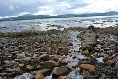
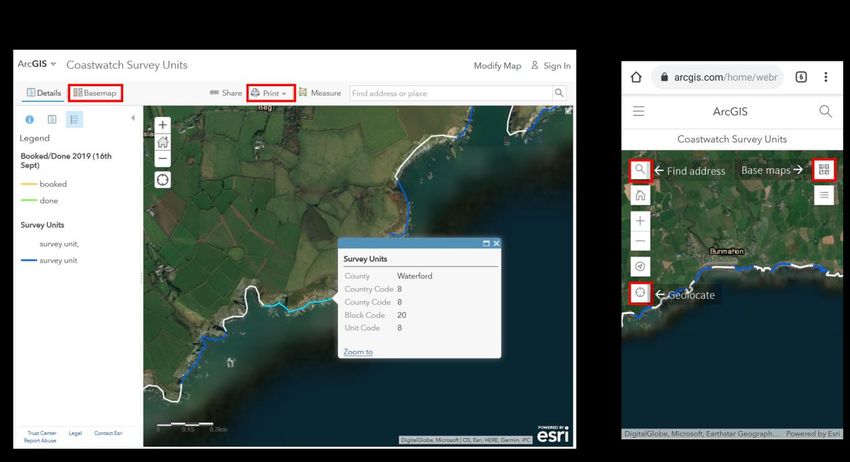
INSTRUCTIONS
1. CHOOSE YOUR SURVEY AREA. There are 2 ways to do this:

A) Go to www.coastwatch.org/europe/map, zoom in on a potential survey area and click on any of the blue or white
coloured lines (each one being a 500m survey unit) to get code. Note this code in Question A1 of the survey form.

   MAP NOTE
   You can access the Coastwatch map with a smart phone when you are in the field. The first page of the survey
   questionnaire carries a QR code. If you scan the QR code with any QR reader app the map will come up (but only
   if there is internet!). So, it is wiser to prepare where you know you can get on line.
   In both the desktop and mobile versions you’ll have a base map selector, a geolocate feature and an address
   search bar.

   Getting a good map of your survey area
   Three options to prepare a survey unit map for use on the shore, (e.g. to identify start/finish of your s.u.): While
   you have internet access select your survey area on the Coastwatch Map, in ‘satellite view’, then either (1) take a
   screenshot which you print to take out with you, or (2) photograph the map on the computer screen using your
   phone, which you can then consult when out on the shore. Its good for zooming in on the photo while out
   surveying, or (3) If you have a smartphone, find the map on your phone and take a screenshot to consult later.
   HINT: include a few s.u., so you can survey the next one, if it’s a great day for roaming around the shore.
   If you don’t have internet access a map of your area can be printed out and sent to you by post. Contact your
   regional or national coordinator (see option b below)
   If you experience any problems with the maps please contact survey@coastwatch.org

B) Contact your Coastwatch (regional) coordinator to have an area allocated, or to join a group of surveyors. The
   regional coordinator or group will provide you with the survey area code and its location.
   www.coastwatch.org/europe/survey Karin Dubsky - +353 (0)86 811 1684 - KDubsky@Coastwatch.org
2. BOOK YOUR SURVEY AREA. There are 2 options to choose from:

A) Book your survey area using our online booking form: http://coastwatch.org/europe/survey/booking/
B)     Contact      your     regional/national      coordinator       and     let   him/her      know      the     area    you        chose.
http://coastwatch.org/europe/wp-content/uploads/2019/09/Regional_Coordinators_2019_14th_Sept.pdf

Booked areas and watching progress
We plan to update the Coastwatch map every 2 days during the survey, so there is some lag between bookings and
those s.u. appearing booked on the map (booked s.u. will be marked in yellow, done s.u. will be marked in green). NOTE:
You can just go out on the spur of the moment as you happen to be on a shore and can get internet access to identify
the survey unit. But if you jump the booking step then please input your findings immediately so we mark the survey
units as done. Most people plan, book and order fresh water quality test kits before surveying. Several reports for the
same s.u. are run as validation checks and so are still valuable.

3. PLAN AND SURVEY

SURVEY PLANNING HINTS

Try to start about 1.5 hours before low tide. Check a tide table, go to www.bit.do/easytide or google ‘low tide and place
or nearest harbour’.

For Groups or school classes sharing a survey unit or a longer stretch of coast
• If a group is doing the same survey unit, we suggest dividing the questions between them at the planning stage – e.g. Some take
   section B (Land/ Inflows), some C&D, while others do (E). All contribute to A, F and extra questions.
• Section (E) lends itself well to splitting between surveyors who are working in pairs (see page 11)
• A master set of all posters should be downloaded or in hard copy with the group leader. Ensure each surveyor (group) has (i)
   the required survey form or page, (ii) at least the basic biodiversity ID poster. (iii) survey area map and those working on litter
   have (iv)downloaded the micro litter app. (v) contact details of another surveyor. (vi) If distributing water test kits make sure
   everyone also has the colour chart to compare nitrate test strip colour with the chart, or give them containers to collect water
   and test on return. Nb - ID Posters can be laminated to be used again.
• Organise group transport logistics. Also don’t forget pickups and a meeting point after the survey. Add time to share findings,
   input data and discuss immediate follow up if needed. Most people are hungry and thirsty on return so a treat is great.
• Photos: get permission to include group members in photos before you go out as that adds to the range of photos and fun.
     NB - You might have devised lots of other clever ways of planning a group survey. We’d be delighted if you were to share this.

SITES TO SURVEY
The more continuous the Coastwatch survey returns in an area – e.g. for a whole 5 km ‘block’, or even 2 adjacent survey
units - the more reliable some of our conclusions may be. If we just pick cleaned beaches, we will get a bias in litter
and in other categories. If it’s possible, choose or include a 500m survey unit you know, as you can provide extra
background information. There are some 80 priority sites which have been surveyed most years. Seasoned priority site
surveyors are notified by email to repeat these or help us find someone else so we keep long time lines.
Accessibility: If a whole survey block is booked, part may be inaccessible. No problem. Please just complete the first
page and make any comments and return that form. ‘No access’ is also important.
TIMING
15th Sept to 15th Oct. survey period. (an overrun is possible in case of bad weather or to avail of a good spring tide)
22nd October: Deadline for your survey results to be submitted online. If posting forms please do so as soon as possible
to allow others to input your data on time. Post to Coastwatch, Civil Eng. TCD, Dublin 2 by Friday 18th Oct.
First result highlight and follow up planning event is either last week of Nov or first in December. All surveyors are invited
to the results highlight launch and workshop. Date and detail to be announced.
International results due in December. And international results exhibition in Brussels in May 2020.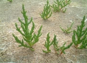
NOTES ON QUESTIONS
A    Background information
A1   The unique code for each 500m survey unit needs to be filled in as provided on the survey map
     http://worldmap.harvard.edu/maps/cwsurveyunits and follow instructions. Please alert Ángel Duarte
     angel88dc@gmail.com if you notice any map or code problems. Some islands and countries are not coded using
     this online system yet but can be done.

A6   Please answer whether you think the area here is designated from previous or present knowledge or from
     posters/signs seen near the shore. This question is to gauge present knowledge and public information not
     research. Research is welcome in A7.

A7   The first column lists most important international and national nature designations. There is super information
     on the sites: google more detail on http://www.unesco.org/new/en/natural-sciences/environment/ecological-
     sciences/biosphere-reserves/ or for Ireland            http://www.dublinbaybiosphere.ie . For Ramsar see
     https://www.ramsar.org and find EU designations with maps on www.natura2000.eea.europa.eu/ for all EU
     countries. For Ireland see www.npws.ie/protectedsites.
      ‘Other’      Nature      designations     includes      regional     ones      like    the       OSPAR       MPAs
     https://www.npws.ie/sites/default/files/general/OSPAR%20MPAs.pdf. In the Rep of Ireland case coastal MPAs
     are all Natura 2000 sites with an extra OSPAR designation label. Designation of further MPAs under the MSFD is
     in progress in most EU countries. Some were identified with citizen participation in N. Ireland and are now
     designated. Legislation to enable MPA designation is to be published in the Rep. of Ireland. Surveyors who know
     an area biodiversity rich and special (e.g. a rich seaweed area, or seagrass meadow and fish nursery not yet
     protected under other legislation) could collect data for proposing such sites as soon as the legislation to do so is
     in place. Coastwatch is hoping to work on this internationally.

     The 2nd column is a mix of human uses and human use designations. If the area is officially designated as Bathing
     water, there are public information requirements to be met and quality standards apply. See
     ec.europa.eu/environment/water/index_en.htm for the EU. There is a public proposal to designate a bathing
     water opportunity. In Ireland the EPA and local authorities have an informative website www.beaches.ie.

     Shellfish Production Areas (Used to be called Shellfish Waters when first designated under the Shellfish Water
     Directive) are officially designated and monitored to ensure the quality of commercial farmed or wild collected
     edible shellfish is fit for human consumption. That Directive has now been brought into the Water framework
     Directive. To see which areas are designated still google ‘designated shellfish water and your country. For Rep of
     Ireland areas see https://data.gov.ie/dataset/register-of-protected-areas-shellfish-areas, for designated sites in
     NI see http://bit.ly/nishellfish.

     ‘Other’ includes shore uses and permits to use, not just designations. So include areas used traditionally for
     seaweed harvesting (whether or not licensed), as well as permits e.g. aquaculture license, seaweed harvest
     license. Evidence of popular bathing and evidence of aquaculture being practised where not designated or
     licensed are also included here. This information is useful for Maritime Spatial Plans (MSP) which are being drawn
     up by EU member states. The first draft MSP for the RoI is due to be published on October 1st

A8   Direct access from hinterland can influence how the shore is used and how a pollution incident may be addressed.
     Think of ‘accessible’ questions as by car, or average wheelchair, or family/group walking with minor climbs, not
     mountain goats!
     If survey unit access is difficult or impossible directly from the hinterland then tick that box, but if it can be
     accessed via other survey units, go ahead and survey ‘from next door’. If you surveyed using boat access tell us
     in A7.
     If your survey unit cannot be reached even from other sites, please tick ‘no access my survey ends here’ and
     return your report. If you have extra notes– e.g. there used to be a road or path but it has eroded, add in A7.
     NB – when you return the form, the area will be marked as surveyed on the master map; we don’t have a
     different colour for ‘inaccessible to survey’. But later in result presentations we plan to map these areas as
     ‘inaccessible and therefore not surveyed’ or’ no direct access, but surveyors accessed and surveyed via other
     units.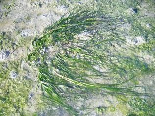
B    Land and inflows
B1   The hinterland and shore are linked, one affects the other. Look out for immediate land use for the first 500 m or
     so above your shore. A good photo can be added. Sea banks which aren’t grazed should be mark as ‘other’ and
     noted in the space provided.

B2   Describe each inflow from land to sea at time of survey as you encounter them walking along your su. There is
     space for 4 inflows to be described (4 columns) If you don’t have enough time concentrate on the biggest one or
     one which needs attention. There is a special focus on small streams as these can be really important as
     biodiversity connectors between land and sea. Some fish get up the smallest streams to spawn, feed or hide. Irish
     surveyors: Look up https://www.catchments.ie if you want to see whether the inflow you see: (1)Officially exists
     and as what (2)Whether it is monitored officially yet (if not your data may be of special value) (3) Whether there
     are any licensed discharges upstream which might effect quality. If you are not sure how to find your way around
     this EPA website, or want to do more on a stream, recent experience from a FLAG project and Irish EPA support
     allows us to provide extra training. Ask Coastwatch coordination to provide it.

     Inflow type
     Inflow types are sometimes difficult to differentiate. Write the first letter of what you think the inflow is in the
     survey form column:

     P - A pipe can be small like a drain from a wall, medium like the one in the picture or a sewage storm water
     overflow which may be dry on day of your survey but should still be recorded as present and the shore below it
     checked for recent sanitary litter indicators.
     S – Seepage is where the water comes out of the ground or bank or wall without a clear source. A pipe could be
     hidden under sand but water emerges as seepage. Also look out for seepage appearing half way down a shore in
     the intertidal as ground water held in a dune may be ‘leaking out’ here.
     D – A drain is usually a small man made cut or ditch to take water from fields. It may be dry except after rain.
     R – Rivers and streams are more natural and larger. Most are carrying water year round in N. Europe but may be
     dry for part of the year in southern countries. NB - If a drain or river passes under a sea road, it will require a
     bridge or a very large pipe culvert. Record the inflow as an R rather than a Pipe. then photograph its mouth.
     Now imagine you were afish trying to enter. Is it easy or is there a weir or step or river obstacle. Try using the
     river obstacles app to record it. Ballymoney stream Co Wexford had its obstacle - a defunct sewer casing removed
     in summer 2019. Lots more can follow. PLEASE ADD STREAM NAME IF KNOWN IN THE TYPE box.

               P                            S                               D                             R

     Size
     Small (S)– medium (M) – large (L) size indication. Think of letting someone know what to look out for if they were
     to find that inflow.
     Quality Indicators

     Animal life: look for both fresh water and sea life. Juvenile fish move up and down. Spend a few minutes on
     searching if it’s a promising stream. A pond dip net can be great. Are there lots of shrimp? If you have a spoon or
     similar implement you might dig into the bank where small eels or lampreys may be hiding. If you lift stones put
     them back. We are not asking for detail in the survey form but.
     Smell: A bad smell might be natural – if seaweeds are decaying in the stream mouth, after a storm. Or you might
     pick up a distinct pollutant sewage, slurry, chemical, or oil smell. Add comment.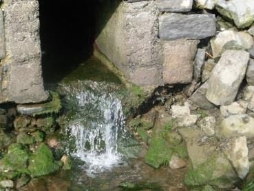
Colour/froth: Tick all discoloration –whether natural brown humic acid rich water from a bog which is natural, or
discoloration after heavy rain. Iron bacteria may also stain the base of a drain or pipe. That isn’t a health hazard
but can look alarming with rust coloured slime. Occasionally you might get industrial source of discoloration.
Photograph if the colour is strange or there is a notable Scum froth.
Dead fish: are quite rare and if you see one please do photograph. If you see several add a count in F6 and contact
relevant authority & Coastwatch. In Ro Ireland report to IFI Phone: (01) 884 2600
Dumped waste and waste washed down an inflow but not sewage related: Bridges are favourite places for rogue
waste disposal, so look out for waste dumped on the seaward or landward side of a stream entering. Photo and
report.
Sewage and sewage related litter: Note that sewage litter from storm water overflows may contain long strings
of wet wipes which started as baby wipes and are now used widely in countries like Ireland. Some are described
as flushable on packaging. Please photograph and count in Litter E 2. This litter leads to sewerage system
blockages and treatment plant breakdowns and hence shore pollution. So it’s on our top list to tackle.
Grey/brown filamentous algae and sewage fungus are in one category, as these have been too difficult to tell
apart. Neither of these are found in a healthy stream. A matt or blanket of these covering the stream bed flags a
problem. So please take a photo. NB – if you see tufts of green filamentous algae this should not be ticked.
Sewage fungus is a soft brownish grey filamentous covering of the inflow floor, or it can float like long dirty grey
hair. Occasionally other colours are mixed in. It is usually slimy and smells of sewage. Sewage fungus is never
green and never has roots. Please add in comments (bottom of page) if you see other issues, especially:
     - a mass of decaying brown seaweeds lodged in the stream channel or lagoon at its mouth. As that rots, it
     uses up the oxygen and becomes a problem for stream life. The water or edge may turn grey white.
     - a layer of fine peat which may cover the inflow floor in areas with peat cutting and inadequate silt traps.
     Peat ‘chokes’ the river bed and is harmful to fish which lay their eggs in the stream bed. In this case could
     you take a sample as evidence, note it in comments and contact us. In Co Meath one Coastwatcher did just
     that and the source was identified by the EPA and addressed.
Oil and look-a-likes: A fine oily film on still fresh water, pooling as it gets into the sea, may be innocent as caused
by iron bacteria. To check, dip a stick into the film and watch what happens: if its iron bacteria, the film breaks
like thin glass, while if its oil, the typical swirls will be seen. Oil pollution is a serious threat! If found please take
photos and if you have a container then a sample. Contact the relevant body to find the source and stop it. Note
the location within the su. and report immediately to local authority and Coastwatch.
Invasive Alien Species: may be seen on the bank of the inflow, at the water’s edge or in the water such as stream
bed. Check our poster www.coastwatch.org/europe/survey and for Ireland www.invasivespeciesireland.com.

Water Quality Tests:
Test Kits are valuable, but expensive and hard work to fundraise. So if you have some, please use them correctly
and ensure you return results!
The most common issue in our freshwater inflows is nutrient enrichment: nitrates and phosphates are nutrients,
which plants need to grow. But too much creates problems and water bodies become eutrophic. Apart from tests
which give the nutrient concentration that second, look out for stream eutrophication indicators (i) brown-grey
filamentous blanket on the stream bed and (ii) super green lush water cress in the water and lush nettles on the
banks.
A typical shore eutrophication indicator is abundant sea lettuce and other green algae on the shore in summer
(it dies off in winter).
As field Nitrate tests are cheaper than phosphate tests and nitrates tend to be the main problem in coastal waters,
we are testing for these in our survey.

Key nutrient sources are septic tanks, leaking sewer pipes, fertiliser and slurry. Our survey takes place when the
slurry spreading season is still open in most areas. Slurry is spread to get nutrients back onto land, not into water
courses. Agricultural pollution controls are in the EU Nitrate directive http://bit.ly/nitratedir and national laws to
implement that EU law. e.g. the Irish nitrate regulations on http://bit.ly/ienitrate.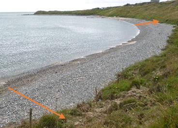
Nitrate/nitrite Test kits

     Each metal strip contains just one test which can only be used once. Make sure you keep strips cool 4-10 C0 and
     dry until you use them and please report back your findings. The colour chart can reused assuming you don’t
     get colour from the test strip all over it. When ready to test:

     1. Open the metallic wrapper at the fine line and pull the test strip out, with the reactive pads area like a lolly
        pop.
     2. Wet the pads by briefly (1 sec) dipping them into the water you are testing. Shake off any excess liquid
        and wait.
     3. After 1 minute (in very cold weather 2 min), compare the colour of the pads with the colour scale (see
        picture) and read off the nitrate concentration. You cannot wait more than 5 min to read, so if you don’t
        have a colour chart with you, take a water sample instead and test later. Photograph the result.
     4. Write down the results in the Question B2 table against the right inflow. If very high you might look is there
        a possible source?
     5. The second pad, closer to your hand, is to pick up Nitrite. This is highly unusual as it quickly degrades to
        nitrate. If you do get a positive nitrite please photograph.

     The pH is a measure how acidic or basic your inflow water is. Most of our run off and stream inflows are about
     neutral (pH of 7) with animals and plants adapted to this. Water is acid - down to pH 4.5 in peat bog areas; often
     with natural brown humic acid discoloration - or alkaline around pH 8 in limestone areas. Seawater is around 8
     pH units.
     The pH scale is logarithmic, so each whole pH value below 7 is ten times more acidic than the next whole value.
     E.g - pH 5 is ten times as acidic as pH 6. For industrial discharges, pH limits may be stipulated in the license. Look
     up catchments.ie and see whether there is a license and get detail.
     Temperature: It must be taken while at the site. Dip the thermometer into the inflow wearing a glove and wait
     long enough.
B3   Sewage pollution may be coming from outside your survey unit, or from a source within it. Sometime a very small
     source can cause nasty localised pollution. It might be raw, or part treated. If ‘seasonal’ it is usually summer and
     it may not be active when you arrive to do the Coastwatch survey. But there may be signs of recent activity. If
     sewage pollution is associated with heavy rain storm water overflows, you might see what you think came from
     a toilet on the base or sides of the inflow. Photograph such sanitary litter. SAMPLES: We do not want water
     samples!!!! as they ‘go off’ quickly and need special storage in cool conditions.

     You can add notes on B2 and B3 in the comments at the bottom of that page.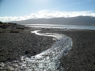
C Splash Zone
C1 The splash zone, also known as ‘supra-tidal’, is the extreme upper limit the sea reaches in highest spring tides. So
look between land and tide lines with washed up material and seaweeds. On rocky shores it may be splashed by
waves, on soft shores specialised habitats can form – see C2.
C2 Saltmarsh and reed beds are valuable wetland soft coast splash zone types, while drift line vegetation or eroding
dune might mark the splash zone of a sandy beach. These are habitats, protected under the EU Habitats Directive
and national law. Building can be a bridge, or harbour wall. ‘Hard erosion control’ is varied from groynes (poles
or rocks built at an angle from the shore to catch sand drifting past, to wire mesh gabions filled with stones,
hugging the edge. If this is an old sea wall, you might check is it being undermined or has stones missing which
isn’t obvious from the landward side. If so a photograph with location is very useful for authorities who are trying
to protect the land behind the sea wall. Get onto your local authority as first port of call. If not responsible they
may know who is. Cc Coastwatch in to your notification.
Builder’s rubble and construction waste are illegal hard erosion controls and also ways to reclaim land. Tick here
and in E1 large waste. Please take photos and notes.
D Intertidal
The D section only applies to tidal areas. So omit in the Baltic and Black Sea. If not familiar with the plants or the
names used (locally these may differ) look at a plant guide, or on the web. A good NW Atlantic seashore guide is
www.marlin.ac.uk/wwf
D3 HIGHER PLANTS
Spartina is a knee-high rigid grass, likely to have seed heads now in autumn. It favours
sand/mudflats, or saltmarsh channels where it can stand like a growing island. One variety
introduced to Europe to reclaim land over 100 years ago, unexpectedly hybridised with a local
species. This hybrid spread around the coast of Ireland and the UK.
While Spartina swards can form rich habitats, this hybrid is invasive taking over valuable open
mudflat habitats and seagrass (Zostera) beds. Reports from new areas, where it was not seen
before and noticeable change in area previously occupied on the shore are of particular
interest.
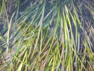
Zostera are silky grasses which live in the sea. Figure1
The little Z. noltii looks like a wet thin grass lawn which is ready for a cut, lying
on the sand/mudflats when the tide is out. It may be patchy as in fig 1. It’s the
most favoured Brent geese food, so watch out where you see geese grazing.
The rarer Zostera marina, has two forms: one (phenotype) grows in wet areas
of the intertidal and pools fig (2) and is easy to identify as a strong up to knee
high grass. If the water is fully out it also lies down. The second phenotype grows
Figure2
from low water down to 10m depth, depending on water transparency and
other factors. It can be a meter or more long and is an important feeding,
shelter and habitat for fish, molluscs, shrimps, sea horses etc. Zostera beds are
threatened and if you find one it’s a real treasure! You might find Zostera plants
floating on the water or dislodged blades washed up. ThIs indicates its growing
in the area. The blades turn shiny black like old tape on the tideline as it dries.
In pollution or anaerobic conditions it might turn white. In the Mediterranean
Posidonia is the dominant seagrass species.
Glasswort or Golden Samphire, Salicornia is listed in the EU habitat directive as
‘Salicornia sward’. Several similar looking fleshy hand high species, grow from
seed in spring on the lower saltmarsh, or upper mud flats. There is also a very
rare perennial one. Salicornia turns red-orange-yellow (hence Golden
Samphire) before shedding seeds in autumn. Some are edible. Snails and
flounders nibble on them too.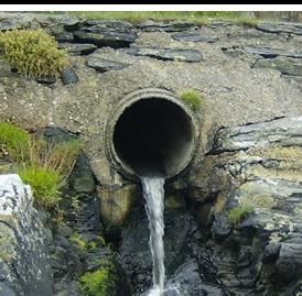
SEAWEEDS:
       The same areas as Spartina and Zostera can be occupied by seaweeds.
       ‘Green algae’ i.e. seaweeds can look similar to Zostera. On closer examination though they do not have the typical
       grass blades with veins, but have bubbly or homogeneous bright green tissue like strands. The other big
       difference is that grass has proper roots which go into the mud or sand, while green seaweeds only have small
       holdfasts to cling to something. NB - Many greens die off in autumn while sea grasses don’t.
       Brown and red algae are what many traditionally call ‘seaweeds’. Most brown seaweeds in the intertidal, are
       leathery and need to hold onto something firm like a stone with their ‘holdfast’. Seaweeds don’t have roots. Kelps
       are like forests of the sea, exposed only at spring tides in the lowest intertidal. See www.seaweed.ie to be amazed
       by the diversity and help you identify a few seaweeds. A new Coastwatch seaweed ID, information on measuring
       and where the growth points are is in preparation and will be uploaded on our website.
D4      Invasive Alien Species are animals and plants that are introduced accidently or deliberately into a natural
       environment where they are not normally found, with serious negative consequences for their new environment.
       They represent a major threat to native plants and animals in Europe, causing damage worth billions of euros to
       the European economy every year. EC Brochure on Invasive Alien Species For work All Ireland see
       http://invasives.biodiversityireland.ie. The Regulation 1143/2014 on invasive alien species entered into force on
       1 January 2015. This Regulation seeks to address the problem of invasive alien species in a comprehensive manner
       so as to protect native biodiversity and ecosystem services, as well as to minimize and mitigate the human health
       or economic impacts that these species can have. The Regulation foresees three types of interventions;
       prevention, early detection and rapid eradication, and management. A list of invasive alien species of Union
       concern has been adopted. Commission Implementing Regulation 2016/1141 adopting a list of invasive alien
       species of Union concern The list was drawn up and managed together with the Member States using risk
       assessments and scientific evidence. The underlying risk assessments are available here.
       Meanwhile we have more species which we need to:           an eye out for,      an eye on and/or actively control!
       Coastwatchers we prepared a draft poster with select IAS which surveyors reported seeing in the last 3 surveys
       on immediate hinterland, on the shore or in shallow water. Download the poster from our website from
       September 15th. We also have a 5 min. video on one of the species New Zealand flax. Phormium tenax. for family
       or school use this puts a different view to the glowing term descriptions for use of this IAS in coastal gardens–
       see this gardening website consulted on Aug 31st 2016:
       https://www.gardenia.net/plant/Phormium-Tenax-New-Zealand-Flax

D5     Discover the biodiversity of your shore! Species groups which most should find if present on the shore are in
       question D5. More detailed information is sought in extra questions – for Ireland and the UK on back page of the
       questionnaire. The biodiversity poster has photos of both D 5 species and extra page to quickly check in the field
       (page 2 of the Irish and UK hard copy forms). When you move seaweed or turn a rock to find animals or their
       eggs, ALWAYS put them back, and do so gently. A little wedge helps avoid squashing life.
       Some common queries and a sting warning:
       ▪ Black shiny blobs stuck on rocks: Likely to be sea anemone with tentacle retracted waiting for the sea to cover
       them again so they can take tentacles out and start feeding.
       ▪ Limpets and Barnacles have the same Irish name but are totally different animals. The limpet is a vegetarian
       mollusc which moves around like your garden snail once the tide comes in to graze on the seaweed film on rocks.
       Barnacles are like tiny grey or whitish volcanoes which cannot move once they are attached to rocks or other
       surfaces. They feed by opening trap doors at the top of their shell.
       ▪ Some jellyfish like the lion’s mane sting badly even when swept up and dead. See Coastwatch jellyfish poster in
       survey materials.
       ▪ If you find one dead or an oiled bird, look around to see if there are more. Can you identify it/them? Is a foot
       ringed? If yes, please take off and note down number and contact BirdWatch/RSPB. Or contact Coastwatch and
       we pass the information on. Please note any dead or injured animals especially if any were entangled in nets or
       litter. Take photos and note location in s.u.
•    Grey seals start pupping in September. If you see a white baby seal, don’t go too close. It cant swim. If possible
     watch from far away whether the mother returns. In storms they can loose their mother. More information from
     http://www.sealrescueireland.org in Courtown or www.irishsealsanctuary.org in Dublin.
E E’s are the litter, waste and pollution questions, which link to the MARPOL Convention for ships and the Marine
Directive (MSFD) which uses litter in our seas as one of eleven sea quality ‘ Descriptors’.
E1 This section is to record large litter items, or piles of smaller ones. For household rubbish, make sure you include
only dumped bin, bag or box loads. Enter individual items of such litter in E2 and 3, not here. The same goes for
dumped crops. A lonely onion does not qualify! We have reintroduced a tyre count. Watch out for used tyres on
the shore to catch peeler crabs. If you see a long line of seaweed mid shore - check it out; it’s probably old tyres.
There is both EU and national law that used tyres must be disposed of in an approved manner. This isn’t one of
them. You pay an eco-tax to the garage on each tyre to ensure it is disposed of correctly.
E2 Drinks container counts are listed on the survey form to cover all forms of containers. Most plastic drinks
containers are bottles, metal ones are cans, glass are bottles. ’Paper outer’ covers tetra-packs etc. with paper
outer and layers of other materials inside. Single use cups were introduced in the form this year due to public
demand Hint: Keep a tally of counts by making notches on the line in groups of 5 - IIII which you later add up.
NB -If several of you are surveying together divide counts of most frequent items between you (cans, bottles..)
Wet wipe count is newly introduced to help tackle this recent problematic litter. Look on the tide mark, shore
corners and around sewer overflows. If wet wipes have formed ropes then count wet wipe ropes and add photos
and comment. Bag counts - plastic shopping bags only not the bigger animal feed or coal bags.
Other counts: Chose what you see as either most common or damaging. Some types of litter are known to be
threats to wildlife - here are a few: Balloons have been found to suffocate sea turtles, packing straps, nets,
aquaculture closure loops and other tangle gear have been found to trap animals, tiny polystyrene and hard
plastic beads are ingested by birds. And larger polystyrene pieces are very likely to disintegrate into beads. If
picking up litter, prioritise the ‘baddies’ for removal.
E3 In E3 no count is required, just tick if present, leave blank if not seen. If walking your shore up and back, it check
one shore level on the way out and another on your way return. Focus on a dirty corner to quickly tick almost
everything. Then that’s done. Most on the first column is some sort of plastic, while the second column tends to
be other materials – except for GEOTEXTLIE added in the 2nd column category, to separate this building material,
used in rock armour, road and other construction. This is becoming increasingly common on our shores and after
review in 2016 is separated out from the wearable textile category.
The ‘hard plastic containers’ include buckets, oil, shampoo, and other bottles, but excludes plastic drinks bottles,
as these are already covered in your count of E2. The ‘other plastics’ is only for plastic not covered in any other
category e.g. twine, fertiliser sacks … . Extra notes are welcome.
E4 Micro litter: Look out for it on the tide mark, in deposition areas and in shallow water. Note what you found.
Micro litter is recognised as a major ingestion and health problem for wildlife and humans. Our research on micro
litter for the new Marine Directive has now moved on from taking samples to using our NEW MICRO LITTER APP
with questions informed by our earlier sample analyses and your comments. Download from
www.coastwatch.org/europe/microlitter and follow the instructions.
If you see something unusual or micro litter of one kind you want us to highlight send us a sample. Make sure
you add the location s.u. code and your name and hand in or post these well wrapped back to us. Results will be
analysed for you and may also be used with your permission in the results exhibition.
E5 Give an impression of where the waste and litter is settling on the shore (also relevant to planning a clean-up)
F
F1 This is to record shore and immediate hinterland changes you have noticed, or know are planned, no matter
whether you think these are good or bad. Look out for gradual change too – like deepening of trampling paths
on dunes. Larger changes may include a new building, erosion control or wind turbines…
F4 This question seeks to pick up threats to your coastal zone. That might be related to the change you already
noted in F3 above, or something which is proposed – such as planning application for something you feel would
threaten the present quality or integrity of your coast. It can also be an on-going pressure or problem. We are
including the threat of Invasive Alien Species (IAS) as an option. Put fire threats under ‘other’. Loss of biodiversity
can be caused by many subtle changes like over harvesting, or change in the way something is harvested. Also
consider cumulative effects.
F5 After all that critic and counts of waste, we hope you can refocus on the special and beautiful elements of your
shore and answer this question on what you like.
F6 Comments can be extended if submitting survey forms on line or on an extra page.NOTES ON EXTRA BIODIVERSITY AND HARVESTING QUESTIONS
Coastwatchers in different seas and countries have developed blocks of extra questions. Those for Ireland and the UK
2018 are included as final page in your survey form. Here an overview of these extras: The ID pictures in the questions
can be downloaded from the web as poster (page 2 of the survey form), or hard copy requested.
Code Extra Questions on: Complete if:
G Biodiversity You are interested in taking a closer look at the animals on your shore. Ideally you are already
reasonably knowledgeable or can get help to find and report on some select worms, molluscs
and fish. The biodiversity poster is a quick reminder of what the species look like.
H Harvesting from the You see or know of aquaculture or harvesting of seaweed or other resources from the shore,
wild and aquaculture or inshore waters in front of your survey unit.
BIODIVERSITY
These extra questions are just picking up a tiny bit of our enormous shore biodiversity. We focus here on 3 worms, 6
native seashells and 2 invasive molluscs. Select a mixed shore with bits of mud, sand, boulders, or rock outcrop to
maximise your chances of finding all. If you are in a rocky shore area and are in a group or school class, you might do a
whole shore project with transect or plan a shore treasure hunt including much more. Use or adapt the Ulster Wildlife
tick posters to do that. You learn a lot about your shore, it’s fun and you can share that information with others. Your
results may highlight special fragile life which needs to be taken into account next time an activity is planned for this
area.
WORMS: Lug worms live in U shaped burrows under the sandy mud flats. Their presence is given away by the squiggles
on the shore. The larger the squiggle, the larger the worm. You might find a nursery area dotted with tiny squiggles high
on the shore, while the old guys live lower down.
Honeycomb worms create s c reefs are only found in a few areas. In one survey, a Wexford county council surveyor
found the longest known intertidal honeycomb reef in Ireland. With our ~7000 km of coast and very few scientists
working on it, your information is really valuable.
Sand masons live buried in the sandy mud sediment but their little tentacle tops stick out and look like tiny dead forests
with whitish branches.
Find more information about Ireland’s biological diversity at http://maps.biodiversityireland.ie/#/Map
SEA SHELLS: There are many species. Those listed in the form are on Poster page 2. See separate seashell posters to
download or ask for hard copy if you have a great diversity on your shore. INVASIVE ALIEN SPECIES: Please report Gigas
Oysters stuck to rocks and Slipper limpets right away.
FISH AND FISH EGG CASES: Many marine fish have juvenile stages which might be picked up in stream mouth. These
can be very difficult to identify. But the general shape does tell us something. If you do have more knowledge please
share. A second place to look is under intertidal rocks where only a few fish live and similar for rock pools. Egg cases
(empty mermaids purses) can be collected and kept for years. You might collect some to ID at home after soaking in
water.
HARVESTING FROM THE SEA:
If you know of use intensity or method changes- e.g. increase/decrease in aquaculture area, bait digging, razor shell
dredging - then do put this into comments. These results will not be published by location. If very unusual, your
consent is sought for any mention of it. If follow up work is needed please shout as we may be able to help or put
you together with others who share this problem. Our aim is to protect our shores and help protect traditional
sustainable uses too. Re fishing and landing animals in Ireland, look at the new SFPA website and booklet with
information on minimum sizes and other rules at http://www.sfpa.ie/
MARITIME SPATIAL PLAN
Local knowledge of traditional rights, archaeology and even who harvests what and when on our shores is important
information and should be considered to be included in our first Maritime Spatial Plan (MSP) which is now being
drafted and due to be published around October 1st. We will update you.Data Return (back at home) INPUT FORM Input your results using our online input form(s) http://coastwatch.org/europe/input-form/ If you can’t send your results online you can post your survey forms for volunteers in HQ to input your data. NOTE ▪ You must complete 1 form per 500m survey unit (it should take 5 to 8 min. to input each form) ▪ If you are submitting data for several survey sites you don’t have to fill in your personal details every time, only the first time (address, telephone, email), for the following submissions just give your full name. ▪ If you haven’t completed the mandatory fields (*) you will not be allowed to submit (survey codes, name, date..) PICTURES AND VIDEOS This year we have a new feature for sending photos from the website. Following this link you’ll be able to upload files directly from your computer, phone or tablet. http://coastwatch.org/europe/send-your-pictures/ You can also email pictures, video clips or any other extra to survey@coastwatch.org Or, if you prefer it, you can post hardcopies or CD to Civil & Environmental Engineering, Trinity College Dublin, College Green, Dublin 2 Categories of video or photo are particularly useful for our Coastwatch survey: 1. Special: fish in a stream, otter footprint, a honeycomb worm reef, sea grass, an amazing patchwork of habitats etc. Catch these with photos or short video(s), upload and add any extra information. Purpose: 1. Celebrate the richness of our shores 2. Inform shore users to prevent damage. 2. Action needed: structural damage to a sea wall, a raw sewage discharge, oil pollution, a dump or infill, defunct materials in the intertidal, a spot where the sea has pooled litter… Your images assist planning the logistics of action. 3. Litter and waste: the large, common and strange and the micro-litter little pieces and pellets you might find. A picture for our exhibition & for feedback on the marine directive (Add object to help gauge scale for small items). 4. You the Surveyors: One nice surveyor shot, with names would be great for exhibition and use in credits collage. 5. Baseline: e.g. - stand on a vantage point and photograph down the splashzone and shore to low water. Then repeat in the opposite direction, standing at low water and taking a shot back to show the shore up as far as the vantage point or higher. A third may cover shore users and signs of use like tracks of humans and of wildlife. Future surveyors can repeat the exercise and view changes in land and shore use. 6. ID: not sure what you found? Carefully video or photograph the animal, plant, feature or object and a marker to locate it again. Use for strange containers & ammunition.
You can also read