Hydrogeomorphic processes and torrent control works on a large alluvial fan in the eastern Italian Alps
←
→
Page content transcription
If your browser does not render page correctly, please read the page content below
Nat. Hazards Earth Syst. Sci., 10, 547–558, 2010
www.nat-hazards-earth-syst-sci.net/10/547/2010/                                                   Natural Hazards
© Author(s) 2010. This work is distributed under                                                        and Earth
the Creative Commons Attribution 3.0 License.                                                    System Sciences

Hydrogeomorphic processes and torrent control works on a large
alluvial fan in the eastern Italian Alps
L. Marchi1 , M. Cavalli1 , and V. D’Agostino2
1 Consiglio   Nazionale delle Ricerche – Istituto di Ricerca per la Protezione Idrogeologica (CNR IRPI), Padova, Italy
2 Dipartimento   Territorio e Sistemi Agroforestali, Università di Padova, Legnaro (Padova), Italy
Received: 17 November 2009 – Revised: 26 February 2010 – Accepted: 8 March 2010 – Published: 23 March 2010

Abstract. Alluvial fans are often present at the outlet of         1    Introduction
small drainage basins in alpine valleys; their formation is
due to sediment transport associated with flash floods and         Alluvial fans at the outlet of small, high-gradient drainage
debris flows. Alluvial fans are preferred sites for human set-     basins are a common feature of alpine valleys. Although de-
tlements and are frequently crossed by transport routes. In        bris flows commonly dominate the formation and develop-
order to reduce the risk for economic activities located on or     ment of these alluvial fans, also bedload and hyperconcen-
near the fan and prevent loss of lives due to floods and de-       trated flows contribute to the transfer of sediment from the
bris flows, torrent control works have been extensively car-       drainage basin to the alluvial fan and its distribution on the
ried out on many alpine alluvial fans. Hazard management           fan surface. These flow processes result in major risk when
on alluvial fans in alpine regions is dependent upon reliable      they encroach settlements and transport routes, which are of-
procedures to evaluate variations in the frequency and sever-      ten present on the alluvial fans of the European Alps. To cope
ity of hydrogeomorphic processes and the long-term perfor-         with flow processes and to reduce their hazard, torrent con-
mance of the torrent training works. An integrated approach        trol works have been built on many alpine alluvial fans. As a
to the analysis of hydrogeomorphic processes and their inter-      consequence, the study of contemporary hydrogeomorphic
actions with torrent control works has been applied to a large     processes must take into account the interactions between
alluvial fan in the southern Carnic Alps (northeastern Italy).     natural phenomena and the control works implemented to re-
Study methods encompass field observations, interpretation         duce the risks on human activities.
of aerial photographs, analysis of historical documents, and          Three steps can be highlighted in the hazard assessment
numerical modelling of debris flows. The overall perfor-           on alpine alluvial fans:
mance of control works implemented in the early decades of
20th century was satisfactory, and a reduction of hazardous            – recognition of the type of sediment transport processes;
events was recognised from features observed in the field and
                                                                       – reconstruction of the frequency and magnitude of haz-
in aerial photographs, as well as from the analysis of histor-
                                                                         ardous events;
ical records. The 2-D simulation of debris flows confirms
these findings, indicating that debris flow deposition would           – runout analysis and mapping of the hazardous areas.
not affect urban areas or main roads, even in the case of a
high-magnitude event. Present issues in the management of          The identification of the type of sediment transport processes
the studied alluvial fan are representative of situations fre-     occurring on alluvial fans, with particular regard to the basic
quently found in the European Alps and deal with the need          differentiation between bedload and debris flows, is a pre-
for maintenance of the control structures and the pressures        liminary step in hazard assessment. The prevailing flow pro-
for land use changes aimed at the economic exploitation of         cesses can be assessed through the recognition of morpho-
the fan surface.                                                   logical and sedimentological evidences (Aulitzky, 1982), or
                                                                   based on morphometric parameters of the drainage basin and
                                                                   the alluvial fan (Jackson et al., 1987; Marchi et al., 1993;
                      Correspondence to: L. Marchi                 Bovis and Jakob, 1999; Wilford et al., 2004; De Scally and
                      (lorenzo.marchi@irpi.cnr.it)                 Owens, 2004).

Published by Copernicus Publications on behalf of the European Geosciences Union.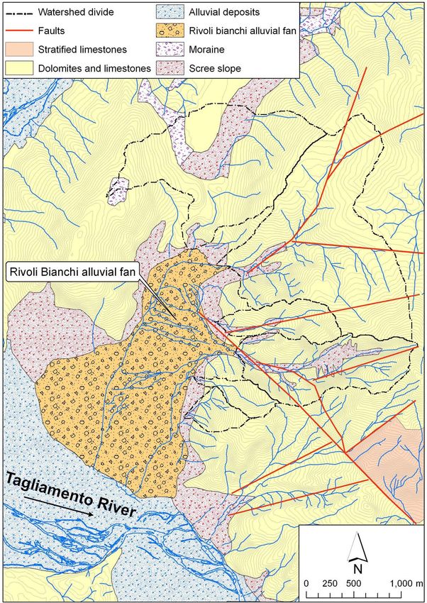
548                                                       L. Marchi et al.: Hydrogeomorphic processes and torrent control works

   The most common approaches in the reconstruction of              the evolution of the vegetation and to identify changes in the
the frequency of sedimentary events on alpine alluvial fans         degree of hydrogeomorphic activity of the alluvial fan. Field
have tended to be the application of dendrogeochronologi-           observations of deposits and channel network were under-
cal methods and the use of historical archival documentation.       taken with the objective of recognising the flow processes
The dating of the events through dendrogeochronology is ap-         (debris flows, floods with bedload) and to evaluate their ac-
plicable on alluvial fans with forests in relatively natural con-   tivity in the various parts of the alluvial fan.
dition. In the European Alps, this requirement is often met on         Numerical modelling of debris-flow propagation and de-
alluvial fans covered by protection forests in the upper val-       position on the alluvial fan was carried out using the FLO-2D
leys (Strunk, 1992; Baumann and Kaiser, 1999; Stefanini and         model (O’Brien et al., 1993). FLO-2D is a two-dimensional
Ribolini, 2003; Bollschweiler and Stoffel, 2007), whereas           flood routing code able to simulate inundation area of mud
farming and urban areas often occupy alluvial fans located at       flows spreading on a floodplain and/or on a channel net-
lower elevations along the lower valleys. The reconstruction        work. FLO-2D follows an explicit finite-difference scheme,
of the frequency of past events from historical archives is par-    which distributes a bulked sediment-graph over a Digital El-
ticularly fruitful where human activities are present and there     evation Model (DEM) of selected square cells by means of
is therefore documentation of the damage caused to buildings        the Saint-Venant equations. The dynamic equation is applied
and land by floods and debris flows (Guzzetti et al., 1994;         for each time step to the eight possible flow directions re-
Barnikel, 2004; Marchi and Cavalli, 2007). Depending on             spect to the central cell and it is combined with the continuity
availability and quality of historical information and topo-        equation for unsteady flow. The inflow volume is described
graphic data of deposits, also the magnitude of past hydro-         by an entering water hydrograph coupled to a time depen-
geomorphic events can be estimated, thus permitting to es-          dent sediment-concentration graph. The model estimates the
tablish magnitude-frequency relations (Brochot et al., 2002;        energy dissipation caused by the mixture motion by means
Helsen et al., 2002; Stoffel, 2010).                                of the rheological model proposed by O’Brien et al. (1993).
   The methods for the zonation of hazard areas on allu-            This model is also known as quadratic model, because the
vial fans can be subdivided into three classes: historical-         total shear stress results by adding to the classic Bingham
geomorphological (Aulitzky, 1972, 1994), empirical and              model the product of a constant by the quadratic shear rate.
semi-empirical (Hungr et al., 1987; Ikeya, 1989) and 2-D            The choice of FLO-2D was suggested by the satisfactory
numerical models (e.g. O’Brien et al., 1993; Liu and Huang,         applications carried out in the Italian Alps under different
2006; Rickenmann et al., 2006). Numerical models have a             lithological conditions and for various debris-flow typologies
relatively large data requirement: their application necessi-       (D’Agostino and Tecca, 2006; Sosio et al., 2006). Model ap-
tates the assessment of debris-flow volumes and peak dis-           plication was intended to assess the deposition zones for a
charges, a sound choice of rheological parameters, and a de-        debris flow of high magnitude. It provided a further test,
tailed representation of the topography of propagation and          alongside the historical approach, based on records of past
deposition areas. Valuable characteristics of numerical mod-        events and aerial photo interpretation, of the effectiveness of
els are the spatially distributed assessment of important vari-     torrent training works.
ables, such as flow depth and velocity, and the possibility of
considering different scenarios of event magnitude and rhe-         3     Study area
ology.
   This paper proposes an integrated approach for the ana-          3.1    Drainage basin and alluvial fan
lysis of hydrogeomorphic processes on alpine alluvial fans,
with particular regard to the assessment of the performance         The Rivoli Bianchi (“White Rills”) alluvial fan is a complex
of torrent control works. Sections 2 and 3 describe, respec-        system of coalescing alluvial fans in the Southern Carnic
tively, methods and study area; Sects. 4 and 5 describe and         Alps (northeastern Italy) (Fig. 1). The alluvial fan covers
discuss the results. Finally, Sect. 6 summarises the main out-      an area of 2.71 km2 , ranges in elevation from 285 to 570 m
comes of the research.                                              and has a mean slope of 6.6◦ . Alluvial fan slope displays
                                                                    a marked variability, ranging from 10◦ –11◦ at the proximal
2     Methods                                                       part to 2◦ –3◦ in the lower areas in the northern and south-
                                                                    western zones.
Study methods include field observations, interpretation of           Six small drainage basins, covering a total area of
aerial photographs, collection and analysis of historical doc-      6.03 km2 , contributed to build the Rivoli Bianchi alluvial fan
uments and numerical modelling of debris-flow propagation           (Fig. 1). These basins are drained by ephemeral streams, on
and deposition. The analysis of published and unpublished           which sediment transport only occurs during intense runoff
historical documents made it possible to reconstruct the oc-        events. One stream, the Rio Citate, was responsible for build-
currence of past floods and debris flows, and the develop-          ing the majority of the alluvial fan. The Rio Citate drains
ment of torrent training works. The interpretation of aerial        a basin of 1.02 km2 , with a range in elevation from 570 to
photographs taken from 1954 to 2003 permitted analysis of           1825 m and an average slope of 49◦ .

Nat. Hazards Earth Syst. Sci., 10, 547–558, 2010                                www.nat-hazards-earth-syst-sci.net/10/547/2010/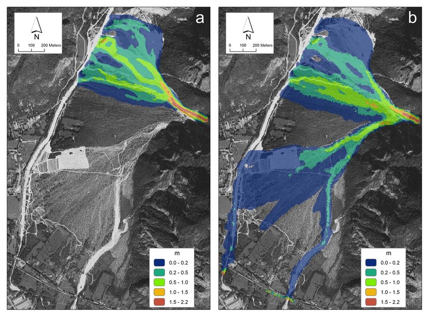
L. Marchi et al.: Hydrogeomorphic processes and torrent control works                                                             549

Fig. 1. Topographic map of the Rivoli Bianchi alluvial fan and up-   Fig. 2. Geological settings of the study area.
slope drainage basins.

                                                                     caused the falling of rock blocks in the drainage basin of the
   Solid bedrock in the study area consists of carbonate rocks       Rio Citate. No quantitative data are available on the vol-
(dolomite and limestone); scree slopes are common at the             umes of debris supplied by the earthquakes to the channel
foot of the rock slopes; the distal part of the alluvial fan         network. However, the sources cited above outline that in
merges into the alluvial deposits of the main river (Taglia-         the time span of concern in this study, which covers the last
mento River) (Fig. 2).                                               100 years, at least two earthquakes caused rock instability in
   The study area is located in a seismically active region          the feeder basin of the Rivoli Bianchi alluvial fan, thus in-
(Boschi et al., 2000; Carulli and Slejko, 2005). On 27 March         creasing the availability of mobilisable debris. The assess-
1928, an earthquake with a maximum intensity IX of the               ment of the role of neotectonics on the long-term evolution
Mercalli-Cancani-Sieberg scale, and whose epicentre was              of the Rivoli Bianchi alluvial fan is beyond the scope and
approximately 6 km southwest of the study area (Boschi et            aims of this paper.
al., 2000), caused a large rockfall in the basin of the Rio             Figure 3 shows the relationship between alluvial fan area
Citate (Gortani, 1928). The most recent strong earthquake            and basin area for a sample of 62 alluvial fans in the east-
occurred in 1976: a shock of 6.4 magnitude on 6 May                  ern Italian Alps. The wide scatter in the relationship is due
was followed by a long seismic sequence with three fur-              to the heterogeneous geolithological and geomorphological
ther strong shocks on 11 and 15 September (magnitude from            conditions in this region. The Rivoli Bianchi alluvial fan lies
5.8 to 6.1). The epicentres of the 1976 earthquakes were             in the upper part of the scatterplot, regardless if the entire al-
at a distance of approximately 10 to 15 km from the study            luvial fan or only the section of it formed by the Rio Citate
area. Widespread landslides (mostly rockfall) triggered by           is considered. The large alluvial fan area is due to abundant
the 1976 earthquakes were described and mapped by Govi               sediment supply from the drainage basins, which in turn is
and Sorzana (1977) and Govi (1977). The map of Govi                  caused by steep slopes, active seismicity and a high degree
and Sorzana (1977) shows that the seismic shocks of 1976             of rock fracturation.

www.nat-hazards-earth-syst-sci.net/10/547/2010/                                  Nat. Hazards Earth Syst. Sci., 10, 547–558, 2010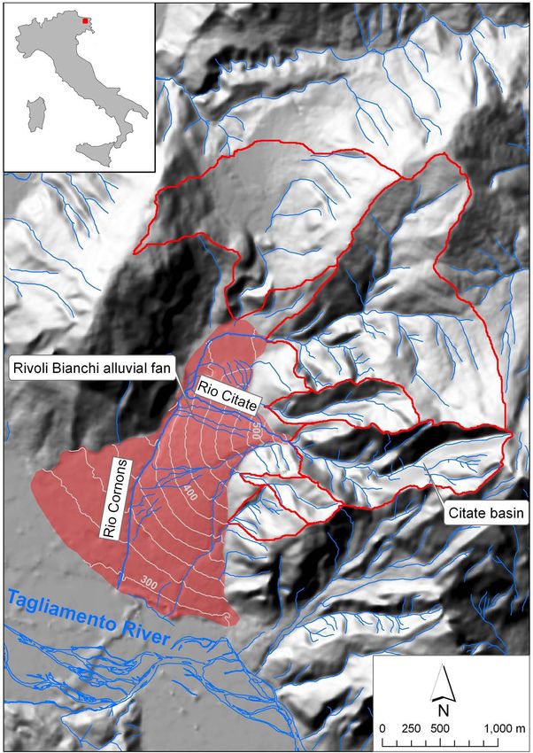
550                                                         L. Marchi et al.: Hydrogeomorphic processes and torrent control works

Fig. 3. Relationship between fan area and basin area in the eastern   Fig. 4. Torrent control structures. (a) Check dam on the Rio Citate
Italian Alps.                                                         close to the fan apex; the wings of the dam (arrow) were raised in
                                                                      1985; (b) Deflection dike (built in 1930s and raised in 1985), (c)
                                                                      check dams on the Rio Cornons in the recession phase of a flood
                                                                      (photo by Simona Scarsini).
   Climatic conditions are typical of the easternmost part
of the Italian Alps, with abundant precipitation throughout
the year: mean annual precipitation amounts to 2000 mm                constructed in the lower part of the left sector and on the
with maximum in November (approximately 250 mm) and                   Rio Cornons, which borders the alluvial fan of the Rio Citate
minima in January and February (approximately 115 mm);                (Fig. 4c).
the average temperature of the warmest and the coldest
months, is 20.1 ◦ C (July) and 0.6 ◦ C (January), respectively.       4     Results
                                                                      4.1    Hydrogeomorphic processes
3.2   Torrent control structures
                                                                      The hydrogeomorphic processes affecting the Rivoli Bianchi
Risk to agricultural areas and transport routes, induced by           alluvial fan and their evolution in the last century were anal-
floods and debris flows in the lower part of the alluvial fan,        ysed by means of historical documents, aerial photos and
has led to the implementation of works aimed at controlling           field surveys.
sedimentary processes.                                                   Scientific papers and documents from historical archives
   Early works, constructed in the 19th century, consisted of         (technical reports, newspaper articles, and written communi-
the construction of an embankment at the western limit of the         cations from local authorities to governmental offices) made
alluvial fan of the Rio Citate along the confluence with the          it possible to reconstruct the occurrence of the most intense
Rio Cornons. In the early 20th century, an attempt was made           alluvial events on the fan, and provided descriptions of the
to channelise the flow in the southern sector of the fan. A           phenomenology.
debris flow that occurred in November 1904 (Gortani, 1906)               Table 1 presents the record of main hydrogeomorphic
caused major damage to these works, showing their inade-              events on the Rivoli Bianchi alluvial fan since the second half
quacy.                                                                of the 19th century. Documents reporting on floods and de-
   More systematic hydraulic works were built in the 1920s–           bris flows regard major events, which have resulted in dam-
1930s (Bonicelli, 1928), with repairs and additions made in           age to properties and transportation routes. Minor events
the following years and decades (Stefanini, 1982). Stone              have not been found in the available documentation, there-
masonry grade-control dams were built within the drainage             fore meaning that the actual frequency of hydrogeomorphic
basin of the Rio Citate and at the fan apex, with the objec-          processes on the Rivoli Bianchi alluvial fan is likely higher
tive of stabilising the channel through the reduction of slope        than that arising from Table 1. The most common damage
(Fig. 4a). A diversion dike was built on the left bank of the         regards the embankment at the western limit of the alluvial
Rio Citate starting from the fan apex, with a length of about         fan; whereas damage to embankments and check dams re-
300 m (Fig. 4b). This structure was intended to direct the            ported after the 1933 and 1935 events indicate that the con-
flow to the right part of the alluvial fan, preventing flood-         trol constructions were already providing some degree of
ing of the left (southern) sector, where at-risk elements (na-        torrent bed stabilisation. Since the 1970s, thanks to the in-
tional road, railway) were located. More check dams were              creased attention of natural hazards and better conservation

Nat. Hazards Earth Syst. Sci., 10, 547–558, 2010                                  www.nat-hazards-earth-syst-sci.net/10/547/2010/
L. Marchi et al.: Hydrogeomorphic processes and torrent control works 551
Table 1. Main hydrogeomorphic events on the Rivoli Bianchi alluvial fan.
Date Damage
7 Oct 1857 Damage to the embankment at the western limit of the alluvial fan.
1 Oct 1893 Damage to the embankment at the western limit of the alluvial fan, flooding of cultivated areas.
23–24 Nov 1904 Widespread flooding of the alluvial fan with deposition of large boulders on the upper part.
Damage to the embankment at the western limit of the alluvial fan,
sediment deposition on cultivated areas, sediment obstruction of bridges.
20–21 Sep 1920 Damage to the embankment at the western limit of the alluvial fan.
9 Oct 1933 Damage to the embankment at the western limit of the alluvial fan. Damage to check dams.
16 May 1935 Damage to the embankment at the western limit of the alluvial fan. Damage to check dams.
Bridges on the National Road and railway clogged by sediment.
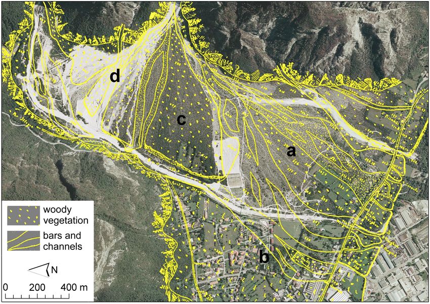
Fig. 5. Historical map of the Rivoli Bianchi fan (Gortani, 1912) overlapped onto an orthophoto taken in 2003. (a) Area characterised by
active hydrogeomorphic processes and major hazard before the implementation of training works. (b) Urban expansion. (c) Central sector
of the fan, already partly vegetated in the early years of 20th century. (d) The northern part of the fan, formerly less active, serves now as
debris deposition area.
of documents, some information is also available for minor typical features of debris flows:
events, which did not cause damage to properties and trans- “. . . the phenomenon of mass transport of gravel along the
port routes (e.g. Querini, 1986). channels occurs, even if the presence of water flowing on
Old documents and papers, when viewed from the mod- surface appears very limited”.
ern perspective, usually contain imprecise terminologies for
A paper by Gortani (1912) presented a topographic map on
the classification of sedimentary processes. However, the de-
the scale of 1:15 000 of the Rivoli Bianchi alluvial fan. This
scription of phenomena often provides elements useful for
map was georeferenced and overlapped onto an orthophoto
the recognition of flow processes. As an example, Boni-
taken in 2003 (Fig. 5). The comparison of these two pictures
celli (1928) provided an effective description of sediment
makes it possible to evaluate the main changes that occurred
transport on the alluvial fan of Rivoli Bianchi, which outlines
in almost 100 years on the alluvial fan. In the Gortani’s
www.nat-hazards-earth-syst-sci.net/10/547/2010/ Nat. Hazards Earth Syst. Sci., 10, 547–558, 2010552 L. Marchi et al.: Hydrogeomorphic processes and torrent control works
Fig. 6. Aerial photographs of the Rivoli Bianchi alluvial fan taken in 1954 (a) and 1993 (b). The arrow indicates a channel that is still active
in the distal part of the fan.
southernmost part of the alluvial fan, indicated by an arrow
in Fig. 6b. The presence of this channel in the lower part
of the fan is due to the inflows from two tributaries located
south of the Rio Citate basin (Fig. 1), and probably also to
saturation overland flow caused by the rise of groundwater
after long-lasting rainfall. Sediment transport processes in
this channel occurs as bedload, and can involve particles up
to the size of pebbles.
Fig. 7. (a) Clast to matrix supported debris-flow deposits close to Field observation allowed identification of sediment trans-
the apex of the alluvial fan. The recession stage of the event caused port and deposition processes currently active on the alluvial
erosion of the deposits, with the formation of different terraces. fan. Sediment transfer from the drainage basin to the alluvial
(b) Bedload deposits in the distal part of the alluvial fan. fan occurs both as debris flows and water floods with bed-
load and suspended load. Deposits ascribed to debris flows
are observed in the upper part of the alluvial fan (Fig. 7a),
map (1912), the most active areas were in the southern and whereas the distal parts are mostly affected by bedload and
southwestern parts of the fan, which were crossed by multi- suspended load transport (Fig. 7b). Debris-flow deposits con-
ple channels. This area is now more stable, and the flow con- sist of angular to subangular, clast to matrix-supported gravel
fined to narrow and well-defined channels. It is also worth and pebbles with scattered boulders; the debris-flow matrix
noting the urban expansion in the southwestern sector of is composed of granules and coarse to silty sand. Over-
the fan, formerly used for agriculture and partially occupied all, these features of debris-flow deposits are consistent with
by active channels (b in Fig. 5). Relatively minor changes those generated from other catchments with dolomite rocks
have occurred in the central part of the fan, which was al- (Moscariello et al., 2002).
ready partly vegetated in the early years of 20th century (c in Historical documents and papers permit reconstructing the
Fig. 5). The northern part of the fan (d in Fig. 5) now serves occurrence of major hydrogeomorphic events on the Rivoli
as a debris storage area. Bianchi alluvial fan, but do not provide data on their magni-
Aerial photographs make it possible to focus on changes in tude. However, the Gortani’s map (Fig. 5) offers elements for
fan surface that occurred since the 1950s. Figure 6 presents an approximate estimation of areas and sediment volumes in-
two photographs of the fan, taken in 1954 and in 1993. In volved in the large hydrogeomorphic events that occurred at
1954, torrent training works had already moved the Rio Ci- the end of 19th century and in the first decades of 20th cen-
tate towards the northern sector of the fan. The most appar- tury. The active sectors of the alluvial fan, which correspond
ent change between 1954 and 1993 is the development of to unvegetated areas on the Gortani’s map, cover 0.76 km2 .
woody vegetation in the southern sector of the fan; where Active areas, occupied by fresh deposits and active channels,
only sparse woody vegetation formerly existed. Woody veg- include both debris-flow deposits and bedload channels and
etation on the Rivoli Bianchi alluvial fan mostly consists of deposits: the occurrence of different flow processes makes
open stands of Mountain pine (Pinus montana) and Austrian it difficult the estimate of sediment volumes. Moreover, the
Pine (Pinus nigra); some trees and shrubs close to old chan- Gortani’s map (1912) does not refer to one specific event: it
nels show evidence of burial by sediment. The development is likely that one event does not affect all active areas. We
of vegetation indicates the relative stability of the fan sur- focus on the debris flows of the Rio Citate, which are the
face. This notwithstanding, a channel is still active in the most hazardous processes on the Rivoli Bianchi alluvial fan.
Nat. Hazards Earth Syst. Sci., 10, 547–558, 2010 www.nat-hazards-earth-syst-sci.net/10/547/2010/L. Marchi et al.: Hydrogeomorphic processes and torrent control works 553
Fig. 8. Maximum annual rainfall and linear trends for durations from 1 to 24 h (a) and from 1 to 5 days (b). Rainfall was recorded at a
raingauge located approximately 3 km from the study area.
Observations of the deposits on the fan surface indicate that the large availability of mobilisable debris in the catchment
the debris-flows deposits of the Rio Citate are present in the make it possible to assess debris-flow discharge from water
central part of the alluvial fan, corresponding to an area of flood according to the volumetric method proposed by Taka-
approximately 0.125 km2 on the Gortani’s map. Assuming a hashi (1978). The sediment concentration by volume (Cv )
mean thickness of the deposits of 1.0 m, we obtain a debris- was supposed linearly increasing and decreasing during the
flow volume of 125 000 m3 . This value of debris-flow mag- rising and falling stage of the hydrograph respectively, and
nitude is affected by approximations in mapping and in the to reach its maximum value at the flood peak (D’Agostino
estimation of the thickness of the deposits and should be con- and Marchi, 2003). It is important to note that the volu-
sidered as a roughly approximate estimate. metric method is not mass conservative, as it implies that
Trends in the time series of intense precipitation have been a water discharge is generated by the failure of the saturated
investigated through the analysis of maximum annual rainfall stream bed and then is added to the triggering discharge dur-
of durations of 1, 3, 6, 12, 24 h and 1 to 5 days, recorded from ing debris-flow formation (D’Agostino, 2006). The FLO-2D
1922 to 1995 at a nearby raingauge. Figure 8 presents the model evaluates the bulked (total water plus sediment) flow
values of maximum annual precipitation and the Sen’s linear rate (Costa, 1984) by means of Eq. (1):
model for the trend (Sen, 1968; Salmi et al., 2002). The Qd = Q0 /(1 − Cv ) (1)
application of the Mann-Kendall test (Hipel and McLeod,
1994) has shown no trend in the time series concerned for where Qd is debris-flow bulked discharge and Q0 is water
most of the durations. However, at a level of significance of discharge. Therefore, when setting up the numerical simula-
0.05, a decreasing trend has been observed for the longest tion, it was decided to scale up the hydrologic flood hydro-
rainfall durations (3, 4 and 5 days). graph by adding the water discharge released from channel-
bed failure. This procedure allowed not to underestimate the
maximum Qd and to save the physical meaning of the sedi-
4.2 Debris-flow modelling ment concentration (maximum Cv value has been set to 0.70;
Table 2).
The FLO-2D model was applied to assess the area flooded by The rainfall-runoff analysis for the computation of the
a high-magnitude debris flow of the Rio Citate on the Rivoli flood hydrograph required by the FLO-2D model was done
Bianchi alluvial fan. The simulation was intended to test the by means of a distributed kinematic hydrological model
performance of control structures in containing debris-flow based on the USDA-SCS method (Chow et al., 1988). The
expansion for a high-magnitude event. Although both debris flood was generated by a hyetograph with 100 years return
flows and floods with bedload occur on the Rivoli Bianchi period, computed from the maximum annual data recorded
alluvial fan, numerical simulation focuses on a debris flow at a raingauge approximately 3 km from the Rio Citate basin.
because debris flows are the main process of sediment trans- The rainfall scenario lasts for 45 min with increasing inten-
fer from the drainage basin to the alluvial fan and display a sity. Table 2 summarises the main characteristics of the sim-
higher hazard than bedload. ulated event.
Debris flows in the Rio Citate originate from erosion and The method adopted for the assessment of debris-flow
entrainment of loose debris from channel bed and banks and volume and hydrograph in the Rio Citate has the advan-
shallow failures of the side slopes. This initiation process and tage of combining geomorphological observations, related to
www.nat-hazards-earth-syst-sci.net/10/547/2010/ Nat. Hazards Earth Syst. Sci., 10, 547–558, 2010554 L. Marchi et al.: Hydrogeomorphic processes and torrent control works
Table 2. Summary parameters of hydrological simulation and as-
sessment of debris-flow event in the Rio Citate.
Rainfall duration (return period of 100 years) [h] 0.75
Cumulated rainfall [mm] 64
Direct runoff [mm] 29
Volume of the hydrologic water hydrograph [m3 ] 29 700
Hydrologic water discharge at the peak [m3 /s] 12.3
Minimum – maximum sediment concentration by volume [–] 0.12–0.70
Bulked and scaled up water plus sediment volume [m3 ] 96 000
Debris-flow peak discharge [m3 /s] 123.0
the recognition of erodible volumes, with the hydrological
assessment of water runoff, i.e. the agent of debris erosion
and entrainment. However, since the assessment of debris-
flow magnitude is affected by relevant uncertainties, a con-
Fig. 9. Comparison of the debris flow of the Rio Citate used for
sistency check with historical data recorded in the same re-
model simulation with a sample of debris-flow volumes recorded
gion is advisable. Figure 9 compares the debris-flow vo-
in the eastern Italian Alps (modified from Marchi and D’Agostino,
lume estimated in the Rio Citate with a sample of 125 de- 2004).
bris flows that occurred in northeastern Italy since late 19th
century (Marchi and D’Agostino, 2004). The debris-flow vo-
lume computed for the Rio Citate lies in the upper part of the
scatterplot of debris-flow volumes versus basin area. This
and Tecca, 2006). Maximum values of flow depths (Fig. 10a)
ensures that the debris flow devised for FLO-2D simulation
and mean flow velocities along the channel – just upstream
represents a challenging event for evaluating the performance
of fan apex – are equal to 1.8–2.2 m and 4.0–4.2 m/s, respec-
of control structures. The estimated debris-flow volume, al-
tively. Such values match well with the channel size and the
though somewhat smaller, has the same order of magnitude
capability of the diverting dike to bear the related maximum
of the volume computed on the Gortani’s map (Sect. 4.1).
pressures.
The large volume of the debris flow is consistent with the
The results of both simulations demonstrate that the
characteristics of the catchment, which is characterised by
flooded fan area (0.19 km2 with Aspen Pit 1 rheology, and
large availability of erodible debris and steep slopes.
0.34 km2 with Kang and Zhang rheology) does not involve
The alluvial fan DEM (10 m grid size) was derived by
the southern part of the alluvial fan. Figure 10a presents the
interpolating elevation data extracted from the topographic
map of maximum flow depths for the Kang and Zhang rheol-
maps of the Friuli Venezia Giulia Region (scale 1:5000; con-
ogy, which computes the largest flooded area. It is possible
tour lines equidistance equal to 5 m). The DEM of the allu-
to note that the longitudinal dike contains the maximum flow
vial fan, including in it the depressions of the incised chan-
depth, and no avulsion occurs to the left banks. The deci-
nels, represented the FLO-2D domain of computation. The
sive role of the diverting dike on the left bank in preventing
FLO-2D levee component was used to describe more accu-
the flooding of the southern sector of the alluvial fan is con-
rately the longitudinal pattern and the top height of the diver-
firmed by model simulation of the same debris flow (Kang
sion dike on the left bank of the Rio Citate (Fig. 4b). The hy-
and Zhang rheology) after removing the dike (Fig. 10b). The
draulic roughness was estimated according to land use on the
channel reach where maximum flow depths occur shortens
fan; the followings values of the Manning coefficient were
(Fig. 10b), but maximum depths do not change (Fig. 10a and
selected: 0.07 for channels and bare debris, 0.10 for sparse
b). Maximum flow velocities are reduced by 10%. Total
shrubs areas, and 0.14 for dense shrubs and trees.
flooded area rises to 0.6 km2 , and the absence of the diversion
Two sets of rheological parameters were used in the analy-
dike causes large areas of the southern sector of the alluvial
sis. The first rheology, named “Aspen Pit 1” in O’Brien and
fan to be inundated, although generally with shallow flow
Julien (1988, p. 882), considers a flow with high values of
depth. It is also possible to observe that the flooded areas
viscosity and yield strength. The second scenario assumes
in Fig. 10b agree well with the active areas of the historical
the “Kang and Zhang” rheology (in O’Brien and Julien,
map by Gortani (1912) presented in Fig. 5: this supports the
1988, p. 882–883), which represents a flow with a medium-
choice of the Kang and Zhang rheology in the simulation of
low shear stress. The “Kang and Zhang” rheology proved
the debris flows of the Rio Citate.
to produce reliable flooded areas for debris flows genera-
ted from dolomite rocks, whose characteristics are similar
to those of the debris flows in the studied area (D’Agostino
Nat. Hazards Earth Syst. Sci., 10, 547–558, 2010 www.nat-hazards-earth-syst-sci.net/10/547/2010/L. Marchi et al.: Hydrogeomorphic processes and torrent control works 555
Fig. 10. Application of the FLO-2D model: map of the maximum flow depths. (a) Actual topography, including the presence of the diverting
dike on the left bank of the channel. (b) Simulation without the diverting dike.
5 Discussion sent a possible concomitant cause, but not the only explana-
tion, for the lack of major hydrogeomorphic events in recent
The lack of major damage from floods and debris flows in decades.
recent decades, as well as the development of vegetation in Control works influence the hydrogeomorphic processes
previously bare areas and the narrowing of the channels in on the alluvial fan both through the decrease of sediment
the southern part of the alluvial fan (Figs. 5 and 6) could transfer from the drainage basin to the alluvial fan, achieved
be ascribed to a variety of causes: the depletion of sediment through the use of check dams on the Rio Citate, and the di-
sources within the drainage basins, rainfall conditions less version of the channel of the Rio Citate toward the northern
favourable to flood and debris flow occurrence, and the effect sector of the alluvial fan. Although it is difficult to discrim-
of the control works. inate the relative importance of the two effects, we note that
Field observations and aerial photo interpretation show grade control structures built in the basin of the Rio Citate
that the availability of mobilisable debris in the drainage do not prevent the flooding of the northern sector of the fan.
basin of the Rio Citate, which dominates the Rivoli Bianchi The diverting dike thus seems to have played a key role in
alluvial fan, is not a limiting factor for the occurrence of de- stabilising the southern sector of the fan, by disconnecting
bris flows. that area from the sediment transport events of the Rio Ci-
The analysis of intense precipitation presented in the tate. This is indicated by the expansion of vegetation onto
Sect. 4.1 is not fully exhaustive because also rainstorms areas formerly almost bare (Fig. 6) or crossed by multiple
that do not correspond to annual maxima may trigger de- active channel (cf. the historical map of Fig. 5). The posi-
bris flows. However, the absence of a significant decreas- tive verification which was conducted through the numerical
ing trend in the most intense rainfall for a wide range of model makes stronger the conclusion (Fig. 10). Neverthe-
durations, including the shortest ones, which are usually as- less a cautionary note is appropriate: the soundness of a spe-
sociated to debris-flow triggering in the region under study, cific application has not to legitimate the dogmatic use of this
suggests that the observed decrease in debris-flow activity mathematical tool to assess debris-flow hazard. Actually, a
could hardly be referred to an attenuation of intense rain- number of physical processes (self-formation of levees, bank
fall. The decrease of rainfall amounts for the durations and bed erosion, flow-state-dependent rheology, multi-phase
from 3 to 5 days could be responsible for an attenuation of flow) are not considered by the model, whose results should
long-lasting floods with sediment transport and could repre- be treated with caution.
www.nat-hazards-earth-syst-sci.net/10/547/2010/ Nat. Hazards Earth Syst. Sci., 10, 547–558, 2010556 L. Marchi et al.: Hydrogeomorphic processes and torrent control works
The reduction of hazard achieved by torrent control struc- built in past decades is of major importance to ensure their
tures, often leads to political pressures to remove land use effectiveness in controlling hazards on alluvial fans. The
limitations. This happens also in the Rivoli Bianchi alluvial long time elapsed from early extensive implementation of
fan, where the stabilisation of the fan surface occurring in torrent regulation works in the Alps has urged studies aimed
recent decades has resulted in an increased pressure for its at evaluating their efficiency, and possible need for mainte-
economic exploitation (farming and cattle-breeding). When nance (Garitte and Lahousse, 2002; Mazzorana, 2008). In
considering these requests, the original objective of torrent the Rivoli Bianchi area, the check dams of the Rio Cornons
control works should be taken into account. With regard to and those built on the left sector of the alluvial fan recently
the case study in this paper, the training works on the Rivoli underwent maintenance works.
Bianchi alluvial fan were intended to protect the road and the
railway located at the southern end of the fan, rather than to Acknowledgements. This research is partially funded by the
achieve a complete stabilisation of the fan surface. These as- European Commission (Sixth Framework Programme, HYDRATE
pects are particularly relevant when the requests for land use Project, Contract No. GOCE-037024) and PRIN 2007 Project
changes do not relate to the use of alluvial fans for agricul- – Italian Ministry MIUR, Dept. TeSAF. The authors wish to
thank Simona Scarsini of the Servizio gestione territorio rurale
ture, as for the Rivoli Bianchi alluvial fan, but the expansion
ed irrigazione of Friuli Venezia Giulia Region for providing the
of urban areas, as often occurs in other alpine areas. geographical data of the study area, and Lucy Clarke for revising
an earlier version of the English text. The comments of two
reviewers (Marcel Hürlimann and Brian McArdell) have permitted
6 Conclusions
to improve the paper.
This study has demonstrated the suitability of a comprehen- Edited by: J. M. Vilaplana
sive approach, based on analysis of historical documents, Reviewed by: M. Hürlimann and B. W. McArdell
aerial photo interpretation, field observations and numerical
modelling of debris flows, for enabling recognition of con-
temporary hydrogeomorphic processes and evaluation of the References
long-term effect of torrent control works on alluvial fans.
Although geomorphic processes causing sediment supply Aulitzky, H.: Vorläufige Wildbach-Gefährlichkeits-Klassifikation
from basin slopes to the channels are still active, and there für Schwemmkegel, Österreichische Wasserwirtschaft, 24, 1–3,
are no evidences of a reduction in intensity of rainstorms, 1972 (in German).
no debris flows with relevant damage have been recorded in Aulitzky, H.: Preliminary two-fold classification of torrents, Mit-
the last decades. The absence of hazardous events since the teilungen der Forstlichen Bundesversuchsanstalt, 144, 243–256,
1982.
late 1930s, which differs from repeated debris-flow damage
Aulitzky, H.: Hazard mapping and zoning in Austria: methods and
observed in the previous decades (Table 1), can thus be as- legal implications, Mt. Res. Dev., 14(4), 307–313, 1994.
cribed to the effectiveness of control works implemented on Barnikel, F.: The value of historical documents for hazard zone
the Rivoli Bianchi alluvial fan. The results of the 2-D nu- mapping, Nat. Hazards Earth Syst. Sci., 4, 599–613, 2004,
merical simulation of a high-magnitude debris flow, carried http://www.nat-hazards-earth-syst-sci.net/4/599/2004/.
out taking into account the control works built on the fan, Baumann, F. and Kaiser, K. F.: The Muletta debris fan, eastern
confirm that flow propagation does not affect areas with el- Swiss Alps: A 500-year debris flow chronology, Arct. Antarct.
ements at risk. Current management considerations of the Alp. Res., 31(2), 128–134, 1999.
Rivoli Bianchi alluvial fan are listed below: Bollschweiler, M. and Stoffel, M.: Debris flows on forested cones -
reconstruction and comparison of frequencies in two catchments
– although control structures have produced a reduction in Val Ferret, Switzerland, Nat. Hazards Earth Syst. Sci., 7, 207–
of hazards, high-magnitude debris flows can still deposit 218, 2007,
considerable amounts of debris on the alluvial fan; http://www.nat-hazards-earth-syst-sci.net/7/207/2007/.
Boschi, E., Guidoboni, E., Ferrari, G., Mariotti, D., Valensise, G.,
– in order to keep the torrent control structures effective, and Gasperini, P.: Catalogue of strong Italian earthquakes from
they must undergo periodical maintenance; 461 B.C. to 1997, Version 3 of the Catalogo dei forti terremoti in
Italia, Ann. Geofis., 43(4), 609–868, 2000.
– the pressures for permitting cattle breeding on the allu- Bonicelli, G.: La sistemazione dei “Rivoli Bianchi” di Tolmezzo,
vial fan raise concerns for the stability of a fragile envi- Annali dei Lavori Pubblici, 66, 23–32, 1928 (in Italian).
ronment and the possible risk of groundwater pollution. Bovis, M. J. and Jakob, M.: The role of debris supply conditions in
predicting debris flow activity, Earth Surf. Proc. Land., 24(11),
These issues and the associated implications are common to 1039–1054, 1999.
many alluvial fans in alpine valleys, in which the decrease Brochot, S., Marchi, L., and Lang, M.: L’estimation des volumes
of frequency and severity of debris flows, achieved thanks des laves torrentielles: méthodes disponibles et application au
to hydraulic works, leads to disregard the persistency of re- torrent du Poucet (Savoie), B. Eng. Geol. Environ., 61(4), 389–
sidual hazards. The maintenance of torrent control works 402, 2002 (in French).
Nat. Hazards Earth Syst. Sci., 10, 547–558, 2010 www.nat-hazards-earth-syst-sci.net/10/547/2010/L. Marchi et al.: Hydrogeomorphic processes and torrent control works 557 Carulli, G. B. and Slejko, D.: The 1976 Friuli (NE Italy) earthquake, Process, Recognition, and Mitigation, edited by: Costa, J. E. and Giornale di Geologia Applicata, 1, 147–156, 2005. Wieczorek, G. F., Geological Society of America, Reviews in Chow, V. T., Maidment, D. R., and Mays, L. W.: Applied Hydrol- Engineering Geology, 7, 201–222, 1987. ogy – International edition, Mc-Graw-Hill, New York, 572 pp., Jackson, L. E., Kostaschuck, R. A., and MacDonald, G. M.: Iden- 1988. tification of debris flow hazard on alluvial fans in the Cana- Costa, J. E.: Physical geomorphologhy of debris flow, in: Develop- dian Rocky Mountains, in: Debris Flows/Avalanches: Process, ments and Applications of Geomorphology, edited by: Costa, J. Recognition, and Mitigation, edited by: Costa, J. E. and Wiec- E. and Fleisher, P. J., Springer-Verlag, Berlin Heidelberg, 268– zorek, G. F., Geological Society of America, Reviews in Engi- 317, 1984. neering Geology, 7, 115–124, 1987. D’Agostino, V.: Le opere di idraulica torrentizia per il controllo dei Ikeya, H.: Debris flow and its countermeasures in Japan, Bulletin sedimenti, Quaderni di Idronomia Montana, 26, 231–250, 2006 of the International Association of Engineering Geology, 40(1), (in Italian). 15–33, 1989. D’Agostino, V. and Marchi, L.: Geomorphological estimation of Liu, K. F. and Huang, M. C.: Numerical simulation of debris flow debris-flow volumes in alpine basins, in: Debris-flow Hazards with application on hazard area mapping, Computat. Geosci., Mitigation: Mechanics, Prediction, and Assessment, edited by: 10(2), 221–240, 2006. Rickenmann, D. and Chen, C., Proceedings of the Third Inter- Marchi, L., Pasuto, A., and Tecca, P. R.: Flow processes on alluvial national Conference on Debris-flow Hazards Mitigation, Davos, fans in the Eastern Italian Alps, Z. Geomorphol., 37(4), 447–458, Switzerland, Millpress, Rotterdam, 1097–1106, 10–12 Septem- 1993. ber 2003. Marchi, L. and D’Agostino, V.: Estimation of debris-flow magni- D’Agostino, V. and Tecca, P. R.: Some considerations on the appli- tude in the Eastern Italian Alps, Earth Surf. Proc. Land., 29(2), cation of the FLO-2D model for debris flow hazard assessment. 207–220, 2004. in: Monitoring, simulation, prevention and remediation of dense Marchi, L. and Cavalli, M.: Procedures for the Documentation of and debris flow, edited by: Lorenzini, G., Brebbia, C. A., and Historical Debris Flows: Application to the Chieppena Torrent Emmanouloudis, D. E., WIT Transactions on Ecology and the (Italian Alps), Environ. Manage., 40(3), 493–503, 2007. Environment, 90, 159–170, 2006. Mazzorana, B.: Das EF30forward Konzept ein Hinweisinstrument De Scally, F. A. and Owens, I. F.: Morphometric controls and geo- zur Ermittlung der Zuverlässigkeit und Funktionseffizienz von morphic responses on fans in the Southern Alps, New Zealand, Wasserschutzbauten, in: Interpraevent 2008 Conference Pro- Earth Surf. Proc. Land., 29(3), 311–322, 2004. ceedings, Dornbirn–Austria, 1, 415–424, 26–30 May 2008 (in Garitte, G. and Lahousse, Ph.: Contribution à l’évaluation de German). l’aléa torrentiel dans le bassin versant du Riou Chanal (Alpes- Moscariello, A., Marchi, L., Maraga, F., and Mortara, G.: Alluvial de-Haute-Provence, France), Géomorphologie: relief, processus, fans in the Italian Alps: sedimentary facies and processes, in: environnement, 8(1), 61–70, 2002 (in French). Flood & Megaflood Processes and Deposits – Recent and An- Gortani, M.: I Rivoli Bianchi di Tolmezzo, Giornale di Geologia cient Examples, edited by: Martini, P., Baker, V. R, and Garzon, Pratica, 4(1), 37–45 1906 (in Italian). G., Blackwell Science, Oxford, UK, 141–166, 2002. Gortani, M.: Materiali per lo studio delle forme di accumulamento. O’Brien, J. S. and Julien, P. Y.: Laboratory analysis of mudflows Falde di detrito e coni di deiezione nella valle del Tagliamento, properties, J. Hydraul. Eng.-ASCE, 114(8), 877–887, 1988. Memorie Geografiche, 20, 339–433, 1912 (in Italian). O’Brien, J. S., Julien, P. Y., and Fullerton, W. T.: Two-dimensional Gortani, M.: Il terremoto del 27 marzo 1928 nelle Prealpi water flood and mudflow simulation, J. Hydraul. Eng.-ASCE, dell’Arzino (Friuli), L’universo, 9(12), 1155–1210, 1928 (in Ital- 119(2), 244–261, 1993. ian). Querini, R.: Le lave torrentizie nelle Alpi e Prealpi Carniche e Govi, M.: Photo-interpretation and mapping of the landslides trig- Giulie: nuovi contributi e conoscenze, L’Italia Forestale e Mon- gered by the Friuli earthquake (1976), Bulletin of the Interna- tana, 41(5), 279–300, 1986 (in Italian). tional Association of Engineering Geology, 15, 67–72, 1977. Rickenmann, D., Laigle, D., McArdell, B. W., and Hübl J.: Com- Govi, M. and Sorzana, P. F.: Effetti Geologici del Terremoto: frane, parison of 2D debris-flow simulation models with field events, in: Studio Geologico dell’area maggiormente colpita dal terre- Computat. Geosci., 10(2), 241–264, 2006. moto friulano del 1976, edited by: Martinis, B., Rivista Italiana Salmi, T., Maata, A., Antilla, P., Ruoho-Airola, T., and Amnell, T.: di Paleontologia e Stratigrafia, 83(2), 329–368, 1977 (in Italian). Detecting trends of annual values of atmospheric pollutants by Guzzetti, F., Cardinali, M., and Reichenbach, P.: The AVI Project: the Mann-Kendall test and Sen’s slope estimates – the Excel tem- A bibliographical and archive inventory of landslides and floods plate application MAKESENS, Finnish Meteorological Institute, in Italy, Environ. Manage., 18(4), 623–633, 1994. Publications on Air Quality No. 31, 35 pp., 2002. Helsen, M. M., Koop, P. J. M., and Van Steijn, H.: Magnitude- Sen, P. K.: Estimates of the regression coefficient based on frequency relationship for debris flows on the fan of the Chalance Kendall’s Tau, J. Am. Stat. Assoc., 63, 1379–1389, 1968. torrent, Valgaudemar (French Alps), Earth Surf. Proc. Land., Sosio, R., Crosta, G. B., and Frattini, P.: Field observations, rheo- 27(12), 1299–1307, 2002. logical testing and numerical modelling of a debris flow event, Hipel, K. W. and McLeod, A. I.: Time series modelling of wa- Earth Surf. Proc. Land., 32(2), 290–306, 2006. ter resources and environmental systems, Elsevier, Amsterdam, Stefanini, S.: Le sistemazioni idraulico-forestali nella Carnia (ba- 1013 pp., 1994. cino montano del Fiume Tagliamento), Regione Autonoma Friuli Hungr, O., Morgan, G. C., Van Dine, D. F., and Lister, R. D.: Debris – Venezia Giulia, Comunità Montana della Carnia, Tolmezzo, flow defenses in British Columbia, in: Debris Flows/Avalanches: 233 pp., 1982 (in Italian). www.nat-hazards-earth-syst-sci.net/10/547/2010/ Nat. Hazards Earth Syst. Sci., 10, 547–558, 2010
558                                                         L. Marchi et al.: Hydrogeomorphic processes and torrent control works

Stefanini, M. C. and Ribolini, A.: Dendrogeomorphological inves-      Strunk, H.: Reconstructing debris-flow frequency in the southern
   tigations of debris-flow occurrence in the Maritime Alps (north-      Alps back to AD 1500 using dendrogeomorphological analysis,
   western Italy), in: Debris-Flow Hazards Mitigation: Mechan-           in: Erosion, Debris Flows and Environment in Mountain Re-
   ics, Prediction, and Assessment, edited by; Rickenmann, D. and        gions, edited by: Walling, D. E., Davies, T. R, and Hasholt,
   Chen C. (Eds.), Proceedings of the Third International Confer-        B., Proceedings of the Chengdu Symposium, Chengdu, China,
   ence on Debris-flow Hazards Mitigation, Davos, Switzerland,           IAHS publ. no. 209, 299–306, 5–9 July 1992.
   Millpress, Rotterdam, 231–242, 10–12 September 2003.               Takahashi, T.: Mechanical characteristics of debris flow,Journal of
Stoffel, M.: Magnitude-frequency relationships of debris flows – A       the Hydraulics Division, ASCE, 104(HY8), 1153–1169, 1978.
   case study based on field surveys and tree-ring records, Geomor-   Wilford, D. J., Sakals, M. E., Innes, J. L., Sidle, R. C., and Bergerud,
   phology, 116(1–2), 67–76, 2010.                                       W. A.: Recognition of debris flow, debris flood and flood haz-
                                                                         ard through watershed morphometrics, Landslides, 1(1), 61–66,
                                                                         2004.

Nat. Hazards Earth Syst. Sci., 10, 547–558, 2010                                   www.nat-hazards-earth-syst-sci.net/10/547/2010/
You can also read