INTEGRATION OF BIM AND ENVIRONMENTAL PLANNING: THE CITYGML ENVPLAN ADE - ÜBERSCHRIFT1
←
→
Page content transcription
If your browser does not render page correctly, please read the page content below
332                                                                                            Full Paper

Integration of BIM and Environmental Planning:
The CityGML EnvPlan ADE
Laura Wilhelm1, Andreas Donaubauer2, Thomas H. Kolbe2
1Chair   of Geoinformatics, Technical University of Munich/Germany · laura_wilhelm@outlook.com
2Chair   of Geoinformatics, Technical University of Munich/Germany

Abstract: While disciplines such as architecture, structural design or technical building equipment have
already integrated their processes, data structures and tools well into Building Information Modeling
(BIM), this has not yet been sufficiently achieved in environmental planning and landscape architecture.
Problems that make integration difficult arise from differences in the scope and scale of the models
needed for building construction on the one hand and environmental planning on the other: while build-
ing construction models focus mainly on the structure itself, environmental planning also considers
natural objects such as habitats and protected areas within a larger radius of the structure. Data about
such objects are typically maintained in GIS, so the integration of BIM and environmental planning is
a matter of BIM-GIS integration. Based on a requirements analysis and an evaluation of existing stand-
ardized information models, this paper presents CityGML EnvPlan ADE, a new 3D information model
for integrating BIM and environmental planning. As a proof of concept, the information model is tested
in a real railroad construction project.
Keywords: Environmental planning, BIM, LIM, 3D GIS, CityGML, spatial-temporal modeling

1        Introduction
Building Information Modelling (BIM) has become mandatory in construction processes in
many countries. BIM pursues the goal of integrating all disciplines working in a construction
process in an overall integrated data environment. While disciplines such as architecture,
structural design or technical building services have already integrated their processes, data
structures and tools well into the BIM process, this is not yet sufficiently achieved in envi-
ronmental planning and landscape architecture (FRITSCH et al. 2019, JUPP 2017, PETERS &
THON 2019). This paper presents a novel approach to integrate BIM and environmental plan-
ning on the level of information models.
In the context of this paper, the term environmental planning serves as a collective term for
the development and implementation of spatially related objectives of environmental poli-
cies. Based on geospatial data, such as protected sites and the mapping of species and bio-
topes, conflicts with planned technical constructions like buildings or infrastructure works
are identified and environmental measures are derived. The results of this process are docu-
mented and visualized on plans, that describe all conflicts and measures related to a specific
construction project.
Consequently, integrating environmental planning into the BIM process means to integrate
digital representations of planned buildings or infrastructure work and the digital representa-
tion of their environmental context. Whereas the construction data originates from BIM au-
thoring tools, the environmental context including environmental conflicts and planned en-
vironmental measures is maintained using Geographic Information Systems (GIS). A major
characteristic of the BIM method is that planning is carried out at least in 3D with time and
cost as two additional dimensions. For environmental planning this leads to a shift from 2D-

Journal of Digital Landscape Architecture, 6-2021, pp. 332-343. © Wichmann Verlag, VDE VERLAG GMBH ·
Berlin · Offenbach. ISBN 978-3-87907-705-2, ISSN 2367-4253, e-ISSN 2511-624X, doi:10.14627/537705030.
This article is an open access article distributed under the terms and conditions of the Creative Commons
Attribution license (http://creativecommons.org/licenses/by-nd/4.0/).
L. Wilhelm et al.: Integration of BIM and Environmental Planning                           333

planning to a multidimensional planning approach, which has to be reflected by an appropri-
ate information model. In general, the construction process requires data at different levels
of detail. Environmental data in GIS is mainly represented at the macro level whereas the
building data in BIM is at the micro level. Therefore, information models from these two
domains have been developed independently and the respective standards differ strongly in
their structure as BIM and GIS are treated as two separate scopes (ZADEH et al. 2019, KOLBE
& PLÜMER 2004). Topographic 3D GIS data can be represented using the City Geography
Markup Language (CityGML), a standardized information model for semantic 3D City and
Landscape models. BIM models can be standardized via the Industry Foundation Classes
(IFC). Since the two standards were developed for different purposes, they have different
structures. IFC comprehensively maps the building structure, CityGML focuses on the 3D
and semantic representation of topography and thus includes thematic domains such as ter-
rain, buildings, streets, vegetation or water bodies (KOLBE & DONAUBAUER 2021, OPEN
GEOSPATIAL CONSORTIUM & BUILDINGSMART INTERNATIONAL 2020, STOUFFS et al. 2018).
Taking into account the information requirements of environmental planning, our investiga-
tions show that neither CityGML nor IFC is capable to represent all the information required
and produced in the environmental planning process.
However, as many tools, data sets and digital methods in environmental planning are based
on GIS, the aim of the integration concept presented in this paper is to use a model from the
geospatial domain as integration platform. Furthermore, there is a wide range of software for
BIM and GIS. So the second aim of the integration concept is to enable a solution, which is
defined independently of a specific software platform. By the standardization of the infor-
mation model, interfaces can be created, which facilitate and simplify the subsequent man-
agement and processing of the data in their respective authoring systems. Consequently, the
integration approach is designed on the level of a standardized, comprehensive information
model.

2     Related Work
2.1   General BIM GIS Integration Research
There are different ways to integrate BIM and GIS. WANG et al. (2019) distinguishes three
typical types: (1) BIM leads and GIS supports, (2) GIS leads and BIM supports, (3) BIM and
GIS are equivalent. HIJAZI and DONAUBAUER (2017) identify four main approaches for inte-
grating BIM/GIS at the standardization level: converting IFC to CityGML, CityGML/GIS to
IFC, a unified model, or linking BIM and Urban Information Model (UIM). BECK et al.
(2020) call for a differentiation between integration efforts in the field of “BIM-GIS Integra-
tion”, as this term serves as an umbrella term. The authors introduce three main categories,
“information characteristic”, “solution characteristics” and “purpose”, the integration ap-
proaches can be differentiated according to their challenge and purpose. A CityGML appli-
cation domain extension (ADE) – i. e. an extension of the standardized CityGML information
model – for example, is located under the “solution characteristics” with sub category “inte-
gration method” and “extension”.
Several studies show that data exchange between GIS and BIM can be useful for both sides
(e. g. CHOGNARD et al. 2018). In the field of automatic conversion from CityGML to IFC a
workflow for the conversion of the different properties for representing real world entities of
334                                           Journal of Digital Landscape Architecture · 6-2021

both standards (semantics, geometry, topology, encoding, georeferencing) has been devel-
oped (SALHEB et al. 2020). Integration of BIM and GIS can also be achieved with generic
triple graph grammar: TAUSCHER (2020) introduces workflows for the generation of IFC and
CityGML metamodels specified as ECore. The workflow for the creation of integration rules
allows its application to future schema extensions, too. LIM et al. (2020) developed a Web-
based viewer, which is able to visualize CityGML ADE-enabled files, as several ADEs for
the BIM to CityGML conversion have been developed.

2.2   BIM GIS Integration in the Environmental Planning Domain
Several integration concepts in the discipline of landscape architecture and landscape plan-
ning are based on the further development of IFC (BRÜCKNER et al. 2019, PETERS & THON
2019, SHILTON 2018, WIK et al. 2018). The Norwegian BIM for Landscape Initiative has
developed a set of definitions, parameters and code lists to represent 44 landscape objects.
The goal is to thereby obtain a uniform standard for landscape objects (WIK et al. 2018). The
UK is developing a BIM for Landscape at the Landscape Institute with Product Data Tem-
plates (PDT) to provide uniform product information. The BIM in Landscape Architecture
Section of the German Chapter of buildingSMART is currently discussing an Information
Delivery Manual for plants and paved surfaces. For example, the PDT will integrate plant
metadata, planting instructions, service life, and process engineering and maintenance
(PETERS & THON 2019, SHILTON 2018). In addition, an Activity Proposal IFC for Site, Land-
scape, and Urban Planning by Jeffrey Ouellette proposes the extension of the IFC schema for
Site, Landscape, and Urban Planning (BRÜCKNER et al. 2019).
The literature emphasizes the importance of 4D-BIM for environmental planning. JUPP (2017)
highlights two interlocking processes for a 4D platform to improve environmental planning
and management. On the one hand, the cooperation of all disciplines of environmental plan-
ning and environmental management must be ensured and on the other hand it must be pos-
sible to monitor the environmental impact on site. In order to meet both requirements, a 4D
model must guarantee five prerequisites: “scheduling and simulation, environmental equip-
ment modeling, construction site layout modeling, environmental impact significance mod-
eling and visualization, rule-checking capability”. SHEINA et al. (2019) also proposes a 4D
BIM for engineering and environmental planning. The technical model should be integrated
into a map displayed using a GIS software. SCHALLER et al. (2016) extended the phases in
the life cycle of a building with environmental planning as BIM-GIS-Cycle. They emphasize
the required data transfer and data exchange at certain points in time during the lifecycle of
a building. For a holistic model, the interfaces between BIM and GIS are seen as a require-
ment. EGGER (2020) sees semantic 3D City and Landscape Models based on CityGML as
basis for an integrated planning model. All relevant geodata are mapped onto the CityGML
data model. The BIM planning is carried out in the imported GIS environment and then in-
tegrated in the CityGML overall model. The work presented in this paper extends this ap-
proach focusing on the specific requirements of environmental planning, which are not fully
covered by the related work described above.
L. Wilhelm et al.: Integration of BIM and Environmental Planning 335
3 Requirements and Existing Information Models
3.1 Requirements for the Integration of BIM and Environmental Planning
The first step in developing a comprehensive information model based on existing standards
was to analyze the general requirements for integrating BIM and environmental planning.
Both literature research and discussion with environmental planning experts from the major
German railway company “Deutsche Bahn" led to the following main requirements:
1. Fundamental geospatial data such as protected sites, project specific data, such as surveys
of vegetation and species, environmental conflicts and measures as well as planned objects
from BIM with their attributes/properties need to be represented.
2. The following use cases in environmental planning should be supported:
environmental impact assessment of the planned building and the construction works,
clash detection and visualization of conflicts between construction and environment,
compensation calculation taking into account the BIM data,
monitoring the construction process from an ecological planning perspective,
monitoring the environmental impact during the operation and maintenance phase of the
building or construction.
3. Special attention must be paid to adequately represent temporal aspects. Four different
temporal domains in environmental planning should be represented in the model: (1) time
spans with fixed absolute start and end time (e. g. important during construction for a fixed
date), (2) recurring regulation time period (e. g. legal time period for clearing woods and
scrubs), (3) date/time period with dependencies on actual/planned construction time (e. g.
continuous ecological functionality (CEF)-measures have to be implemented before con-
struction start), (4) task depending on predecessor task (e. g. construction of a substitute hab-
itat before the relocation of specific species).
3.2 Assessment of Existing Information Models
In a second step, various standards were examined for their ability to meet the requirements
of integrating BIM and environmental planning as described in section 3.1. Six standards
were identified to be suitable for modelling environmental planning as they fulfil parts of the
listed requirements: CityGML, INSPIRE (Infrastructure for Spatial Information in Europe)
and LandInfra (Land and Infrastructure) as international standards, XPlanung and OKSTRA
(Objektkatalog für das Straßen- und Verkehrswesen) as German national standards. Further-
more, IFC as BIM standard and approaches to extending IFC by landscape objects were eval-
uated. The result of the comparison is found in table 1: “++” means that the standard fully
fulfills the requirements, “+” means some requirements are fulfilled and “-“ means none of
the listed requirements were fulfilled. For the specific requirements of environmental plan-
ning, CityGML offers a good foundation with the support of vegetation, water and different
land use (GRÖGER et al. 2012). IFC as construction standard could map technical components
used in environmental planning such as protection fences. Landscape objects could be repre-
sented using generic object types like IFC_Proxy or (mis-)using other classes like IFC_Wall,
but the semantics would not be explicitly clear. IFC does not include the mapping of objects,
which are important for the definition of project specific environmental data, e. g. protection
sites or environmental measures. OKSTRA allows the mapping of landscape planning ob-336 Journal of Digital Landscape Architecture · 6-2021
jects (landscape, conflict, measure) (HEINS & PIETSCH 2010), but the representation of dy-
namics is not possible. In XPlanung the core “Landscape planning” (BRENNER 2019) is fo-
cused on representing legal landscape plans as part of the zoning of a municipality and is
therefore not detailed enough for representing environmental planning of an individual con-
struction project. The INSPIRE data specifications are not specifically adapted to environ-
mental planning, apart from representing protected sites (INSPIRE THEMATIC WORKING
GROUP PROTECTED SITES 2010), and, apart from buildings and DTM, 3D objects are not
supported. LandInfra covers a few aspects of environmental planning, e. g. vegetation, but
not sufficiently, for example regarding the representation of temporal aspects. In relation to
the temporal representation, CityGML supports both the static time component (GRÖGER et
al. 2012) and dynamics, with the Dynamizer ADE (CHATURVEDI & KOLBE 2016). The com-
prehensive time representation of IFC (BUILDINGSMART 2020) is inconvenient for environ-
mental planning due to the separate handling of the work calendar (IfcWorkCalender), as
temporal information should be directly added to the specific object. INSPIRE, LandInfra
and XPlanung only support basic static representations of time, which are not sufficient
enough for environmental planning. For example the INSPIRE data specification “species
distribution” (INSPIRE THEMATIC WORKING GROUP SPECIES DISTRIBUTION 2013) defines
no activity period for a species. OKSTRA defines temporal properties for environmental
measures (BUNDESANSTALT FÜR STRAßENWESEN 2019), but the specification of time periods
is missing.
Table 1: Comparison of different standards according to their integration of requirements
regarding BIM and environmental planning
CityGML IFC 4 INSPIRE LandInfra XPlanung OKSTRA
2.0
construction data + ++ – – + +
fundamental geospatial data + + + + + +
project specific environmental data + – + + + +
environmental conflict – – – – – ++
environmental measure – – – – + ++
impact assesment ++ + – – – –
ecological construction supervision – – – – – –
monitoring environmental impact + + + - – –
time: static + ++ + + + ++
time: dynamic ++* + – – – –
3D ++ ++ + ++ – ++
extensibility ++ + + + ++ +
*Dynamizer ADE, a CityGML extension to support time dynamic property values
++ comprehensive*, + basic*, – not included*; *according to personal assessment
The comparison in table 1 reveals that none of the selected information models is fully match-
ing the requirements. However, CityGML was chosen as the basis for developing a compre-
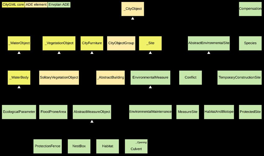
hensive information model for the integration of BIM and environmental planning for theL. Wilhelm et al.: Integration of BIM and Environmental Planning 337 following reasons: First, the semantic model of CityGML is able to represent many required objects (these are already represented in 3D, as required by the BIM process). Second, CityGML provides the Application Domain Extension (ADE) mechanism, which allows for extending the information model according to the requirements of an application domain. This is a unique property of CityGML compared to the other standards mentioned above, besides XPlanung, which also uses the ADE mechanism, but only supports 2D. For example, IFC can easily be extended by application specific attributes (property sets), however, it is not possible to add new classes to the IFC information model without running through a formal buildingSMART process that involves user consensus and validation. We applied the CityGML ADE mechanism for developing the Environmental Planning ADE (EnvPlan ADE), a comprehensive information model for integrating environmental planning and BIM. 4 The CityGML EnvPlan Application Domain Extension Figure 1 gives an overview of the CityGML EnvPlan ADE, which was developed based on the requirements described in section 3.1. The extended classes of the CityGML core module are marked yellow. Existing CityGML classes that are extended by attributes are marked in orange. The newly created classes of the EnvPlan ADE are highlighted in green. Concepts of existing CityGML modules as well as from the other standards described in section 3 have been reused wherever possible in order to facilitate data integration from existing data sources. New attributes are assigned to the classes AbstractCityObject, AbstractBuilding and Soli- taryVegetationObject, for example in order to represent the cost of environmental measures as well as the construction cost for the new buildings or infrastructure works. New classes are derived from AbstractSite, AbstractBuilding, CityFurniture and AbstractWaterObject. AbstractEnvironmentalSite and Species are specializations of AbstractCityObject. Abstract- EnvironmentalSite is a container of common properties of sites where environmental measures are planned for (MeasureSite), mapped habitats and biotopes (HabitatAndBiotope), sites un- der environmental protection (ProtectedSite, reused from INSPIRE) and construction site fa- cilities, that are removed after construction is completed (TemporaryConstructionSite). Information without geometric representation is modelled as specializations of the CityGML class AbstractSite: these are measures (EnvironmentalMeasure, aligned with OKSTRA), their maintenance (EnvironmentalMaintenance, aligned with OKSTRA) and Conflicts (aligned with OKSTRA). These objects get a spatial representation when they are actually imple- mented, which is expressed by relating them to measure areas (MeasureSite) or measure ob- jects (AbstractMeasureObject). AbstractMeasureObject is derived from the CityGML class CityFurniture, as measure objects like protection fences or nest boxes are immovable objects and can be geometrically represented by prototypes (e. g. 3D geometries from an object li- brary). The class Compensation has an association with the class AbstractCityObject, which allows to assign environmental compensation values (see use case in section 5.2) to each object causing an environmental impact.
338                                           Journal of Digital Landscape Architecture · 6-2021

Fig. 1: Structure of the Environmental Planning Application Domain Extension
        (EnvPlan ADE) for CityGML as a UML class diagram

Fig. 2: Implementation of the four different temporal domains in the EnvPlan ADE

The requirements related to the four different temporal domains used in environmental plan-
ning were taken into account, for example, by adding a temporal reference to the class Envi-
ronmentalMeasure (see Fig. 2). The specific temporal attributes are implemented according
to the mentioned prerequisites. Besides the data type “date” for specific start and end times
L. Wilhelm et al.: Integration of BIM and Environmental Planning 339
(case 1 of the temporal requirements defined in section 3.1), the depending time periods are
represented. Recurring periods (case 2) are implemented as RegulationPeriodValue. Since
the duration of the construction project can last several years, the object constraint language
(OCL) rules shown in the UML diagram ensure that no year is specified for the periods and
that the start time is before the end time. The dependence on the construction time (case 3) is
modelled as RealisationSchedule. Regarding the actual construction time, the number of days
before, during or after construction start/end has to be added. The case of a predecessor meas-
ure (case 4) is solved by using a reflexive association and the number of days between both
measures.
The UML model EnvPlan ADE is converted into an XML Schema using the software
ShapeChange 1. The UML model, as well as the XML Schema files, are provided on GitHub 2.
5 Proof of Concept
The EnvPlan ADE was tested using BIM and GIS data from a railway project – the refur-
bishment of a train station and the extension of a train platform, located in Bavaria, Germany.
5.1 Implementation of the EnvPlan ADE as a Spatially Extended Relational
Database Schema
The conceptual model as described in section 4 was implemented as a spatially extended
relational database schema using the tools provided by the open source project 3DCityDB
(YAO et al. 2018). This allows to automatically derive the database schema for any CityGML
ADE from the UML model. 3DCityDB is based on the database management systems Post-
greSQL with PostGIS extension or ORACLE. In our implementation, PostgreSQL was used.
The queries and analyses described in section 5.3 can then be defined using SQL statements.
5.2 Data Integration Workflow
The construction model was exported from the BIM authoring tool Autodesk Revit to the
IFC format. For the environmental planning data, different sources were used: fundamental
geospatial data from a public Web Feature Service, project related data (format: Shapefiles)
and information from the conflict and measure plan (formats: Shapefiles, DWG). The GIS
data of the environmental planning and BIM data of the construction planning were trans-
formed into the CityGML EnvPlan ADE using the tool FME (Feature Manipulation Engine,
Safe Software). The transformation included a process to lift the 2D environmental planning
data to 3D and the data import into the PostgreSQL database with 3DCityDB schema. In this
process, fundamental geospatial data, such as protected sites were transformed to planar pol-
ygons or line strings floating at a specific height level (the reference height of the construction
project). Project specific environmental data, such as measure sites and objects, were draped
over the digital terrain model, which results in high resolution triangulated geometries for
these objects. All project relevant data from construction and environmental planning was
visualized as an overall model (see Fig. 3). The test proved that all relevant planning data can
1 https://shapechange.net
2 https://github.com/tum-gis/CityGML-EnvPlan-ADE340 Journal of Digital Landscape Architecture · 6-2021
be successfully transformed to CityGML EnvPlan ADE and thus an integrated data environ-
ment for BIM and environmental planning can be realized.
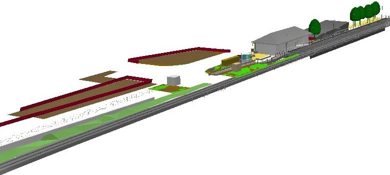
Fig. 3: Overall model showing objects from construction and environmental planning; the
construction objects are visualized in grey; the colored features are environmental
measure sites and objects
5.3 Queries and Analyses Based on the Information Model
In the following, two use cases based on the information model are described as examples.
The first use case shows clash detection and visualization of conflicts between construction
and environment. To find space for temporary construction areas, spatial-temporal queries
can be performed. These queries check whether this is possible on the start day of the con-
struction period (in the railway project: construction period from 2021-02-01 until 2021-08-
31). The query shows which environmental measure affects the areas and whether there are
time restrictions related to the start day of construction (2021-02-01). The result of this spatio
temporal clash detection is shown in table 2. The temporary construction areas are spatially
intersected with the environmental measure areas. The column “possible” shows that the con-
struction site cannot be set up on the 1st of February as environmental measure specifies a
time regulation for tree cutting from 1st October until 28th of February.
Table 2: Clash detection of the date for the setting up of temporary construction site
measureid measuredescription startday startmonth endday endmonth possible
002_VA clearing woods 1 10 28 2 FALSE
The second use case is about an automatic compensation analysis. By law 3, any intervention
in the environment must be compensated. This calculation is an important part of environ-
3 The used railway project takes place in a city in Bavaria, Germany, so the regulation of the state of
Bavaria was applied: https://www.lfu.bayern.de/natur/kompensationsverordnung/index.htm.L. Wilhelm et al.: Integration of BIM and Environmental Planning 341
mental planning and is represented in the EnvPlan ADE by the class compensation. The com-
pensation calculation is integrated into the data integration workflow as described in section
5.2 above and therefore carried out using FME, but it could also be implemented using any
GIS software, that is able to connect to a PostGIS database or directly in PostGIS using as a
set of database queries.
In our railway project, the newly built and thus sealed areas, the temporary construction areas
and the cut trees have to be compensated. For calculating the compensation value, a formula
specified by law³ is used. Using this formula, the compensation value is calculated as im-
pacted area times value of the underlying biotope times a factor depending on the type of
impact (sealing, planting, construction, operation). To determine the impacted area, the areas
affected by the construction (objects of classes Building and TemporaryConstructionSite) are
spatially intersected with the mapped biotopes (objects of class HabitatAndBiotope and Sol-
itaryVegetationObject). The values of the underlying biotopes are derived from attributes of
the class HabitatAndBiotope, the type of impact is derived from the type of the object causing
the impact (Building sealing, TemporaryConstructionSite construction). The result of
this calculation is represented as an object of the class Compensation.
The use cases and their implementation are described in greater detail in the master thesis by
WILHELM (2020).
6 Conclusions and Outlook
The EnvPlan ADE supports the integration of environmental planning with BIM regarding
the following aspects:
Common standards-based information model and data format including relevant data
from different disciplines involved in the BIM process: This enables standardization of
interfaces and still being able to use different software tools from the respective domains.
In our approach CityGML is used as a comprehensive model combining construction
data and environmental data on one platform.
Combining the requirements of environmental planning for BIM-integration in a com-
prehensive information model: BIM projects are still lacking environmental context in-
formation and the EnvPlan ADE can be used to standardize the required environmental
data.
Spatio-temporal representation: The EnvPlan ADE allows a 4D-BIM for environmental
planning. This supports e. g. the generation of construction time tables and spatio-tem-
poral clash detection between construction and environmental planning.
The EnvPlan-ADE extends CityGML and defines a specialized model for environmental
planning. Future work will focus on the one hand on testing the ADE with further real world
projects and use cases. On the other hand, the round trip BIM authoring tool CityGML
EnvPlan ADE BIM authoring tool will be investigated.
References
BECK, F., BORRMANN, A. & KOLBE, T. H. (2020), The need for a differentiation between
heterogeneous information integration approaches in the field of “BIM-GIS Integration”:342 Journal of Digital Landscape Architecture · 6-2021 a literature review. Proceedings of the 3rd International BIM GIS Integration Workshop (ISPRS Annals of the Photogrammetry, Remote Sensing and Spatial Information Sci- ences). BRENNER, J. (2019), XPlanung. Struktur und Konzepte. http://www.xplanungwiki.de/upload/XPlanGML/5.0/XPlanInfoDoc.pdf (10.01.2021). BRÜCKNER, I., MAßLING, N., WOZNIAK, M. & THIEME-HACK, M. (2019), How to develop a BIM-Workflow for landscape architecture: A practical approach. Journal of Digital Land- scape Architecture, 4-2019, 122-130. BUILDINGSMART (2020), Industry Foundation Classes 4.0.2.1. Version 4.0 – Addendum 2 – Technical Corrigendum 1. buildingSMART International Limited. https://standards.buildingsmart.org/IFC/RELEASE/IFC4/ADD2_TC1/HTML/ (10.01.2021). BUNDESANSTALT FÜR STRAßENWESEN (2019), OKSTRA 2.029. http://www.okstra.de/docs/2019/html/index.htm (10.01.2021). CHATURVEDI, K. & KOLBE, T. H. (2016), Integrating dynamic data and sensors with semantic 3D city models in the context of Smart Cities. ISPRS Ann Photogramm Remote Sens Spatial Inf Sci. 4, 31-38. CHOGNARD, S., DUBOIS, A., BENMANSOUR, Y., TORRI, E. & DOMER, B. (2018), Digital con- struction permit: A round trip between GIS and IFC. Workshop of the European Group for Intelligent Computing in Engineering, 287-306. Springer, Berlin/Heidelberg. https://doi.org/10.1007/978-3-319-91638-5_16 (10.01.2021). EGGER, F. (2020), 3D-CityGML-Stadtmodelle als Planungsinstrument für BIM-Infrastruk- turprojekte am Beispiel der U4-Netzerweiterung auf die Horner Geest in Hamburg. In: DVW E. V. & RUNDER TISCH GIS E. V. (Eds.), Leitfaden Geodäsie und BIM. Version 2.1, 184-186. Bühl, München, Germany. https://rundertischgis.de/images/download_leitfaden_c4.php (10.01.2021). FRITSCH, M., CLEMEN, C. & KADEN, R. (2019), 3D landscape objects for Building Infor- mation Models (BIM). ISPRS Ann. Photogramm. Remote Sens. Spatial Inf. Sci., IV- 4/W8, 67-74. https://doi.org/10.5194/isprs-annals-IV-4-W8-67-2019 (10.01.2021). GRÖGER, G., KOLBE, T. H. NAGEL, C. & HÄFELE, K. (2012), OGC city geography markup language (CityGML) encoding standard. HEINS, M. & PIETSCH, M. (2010), Fachtechnische Standards für die vorhabenbezogene Land- schaftsplanung. In: Edition Hochschule Anhalt, Selbstverlag, 125. HIJAZI, I. & DONAUBAUER, A. (2017), Integration of building and urban information mode- ling-opportunities and integration approaches. In: KOLBE, T. H., BILL, R., DONAUBAUER, A. (Eds.), Geoinformationssysteme 2017. Beiträge zur 4. Münchner GI-Runde. Wich- mann, Berlin/Offenbach. INSPIRE THEMATIC WORKING GROUP PROTECTED SITES (Ed.) (2010), D2.8.I.9 INSPIRE Data Specification on Protected Sites – Guidelines. http://inspire.jrc.ec.europa.eu/docu- ments/Data_Specifications/INSPIRE_DataSpecification_PS_v3.1.pdf (10.01.2021). INSPIRE THEMATIC WORKING GROUP SPECIES DISTRIBUTION (2013), D2.8.III.19 Data Specification on Species Distribution – Technical Guidelines. European Commission Joint Research Centre (Ed.). https://inspire.ec.europa.eu/file/1526/download?token=agVvUHPi (10.01.2021). JUPP, J. (2017), 4D BIM for environmental planning and management. Procedia engineering, 180, 190-201. KOLBE, T. H. & DONAUBAUER, A. (2021), Semantic 3D City Modeling and BIM. In: SHI, W., GOODCHILD, M., BATTY, M. et al. (Eds.), Urban Informatics. Springer, Singapore.
L. Wilhelm et al.: Integration of BIM and Environmental Planning                        343

KOLBE T. H. & PLÜMER, L. (2004), Bridging the gap between GIS and CAAD: Geometry,
   referencing, representations, standards and semantic modelling. In: GIM International,
   18, 12-15.
LIM, J., JANSSEN, P. & BILJECKI, F. (2020), Visualising detailed CityGML and ADE at the
   building scale. Int. Arch. Photogramm. Remote Sens. Spatial Inf. Sci., XLIV-4/W1-2020,
   83-90. https://doi.org/10.5194/isprs-archives-XLIV-4-W1-2020-83-2020.
OPEN GEOSPATIAL CONSORTIUM & BUILDINGSMART INTERNATIONAL (2020), Built envi-
   ronment data standards and their integration: an analysis of IFC, CityGML and LandInfra.
   Version 1.0. OGC Document 19-091r1. https://www.ogc.org/docs/discussion-papers
   (Download) (25.03.2021).
PETERS, A. & THON, A. (2019), Best practices and first steps of implementing BIM in land-
   scape architecture and its reflection of necessary workflows and working processes. Jour-
   nal of Digital Landscape Architecture, 4-2019, 106-113.
SALHEB, N. (2020), Automatic Conversion of CityGML to IFC. Int. Arch. Photogramm. Re-
   mote Sens. Spatial Inf. Sci., XLIV-4/W1-2020, 127-134.
   https://doi.org/10.5194/isprs-archives-XLIV-4-W1-2020-127-2020 (25.03.2021).
SCHALLER, J., GNAEDINGER, J., REITH, L., FRELLER, S. & WEIZENEGGER, M. (2016), GeoDe-
   sign. Konzept zur Integration von BIM und GIS in der Umweltplanung. In: ERNST &
   SOHN, BIM-Building Information Modeling. Ernst & Sohn, Berlin, Germany.
SHEINA, S., SERAYA, E., KRIKUNOV, V. & SALTYKOV, N. (2019), 4D BIM for construction
   planning and environmental planning. E3S Web Conf., 110 (47), 1012.
   doi:10.1051/e3sconf/201911001012.
SHILTON, M. (2018), Digital Futures – BIM in landscape design: A UK perspective. Journal
   of Digital Landscape Architecture, 3-2018, 236-240.
STOUFFS R, TAUSCHER H & BILJECKI F (2018), Achieving complete and near-lossless con-
   version from IFC to CityGML. ISPRS International Journal of Geo-Information, 7 (9),
   355.
TAUSCHER, H. (2020), Towards a generic mapping for IFC-CityGML data integration. Int.
   Arch. Photogramm. Remote Sens. Spatial Inf. Sci., XLIV-4/W1-2020, 151-158.
   https://doi.org/10.5194/isprs-archives-XLIV-4-W1-2020-151-2020.
WANG, H., PAN, Y. & LUO, X. (2019), Integration of BIM and GIS in sustainable built envi-
   ronment: A review and bibliometric analysis. Automation in Construction, 103, 41-52.
WIK, K. H., SEKSE, M., ENEBO, B. A. & THORVALDSEN, J. (2018), BIM for landscape: A Nor-
   wegian standardization project. Journal of Digital Landscape Architecture, 3-2018, 241-
   248.
WILHELM, L (2020), Integration von BIM und Umweltplanung am Beispiel der Deutschen
   Bahn. Masterarbeit, Technische Universität München, Lehrstuhl für Geoinformatik.
   https://mediatum.ub.tum.de/node?id=1554543 (05.02.2021).
YAO, Z., NAGEL, C., KUNDE, F., HUDRA, G., WILLKOMM, P., DONAUBAUER, A., ADOLPHI, T.
   & KOLBE, T. H. (2018), 3DCityDB – a 3D geodatabase solution for the management,
   analysis, and visualization of semantic 3D city models based on CityGML. Open Geo-
   spatial Data, Software and Standards, 3 (5), 1-26.
ZADEH, P. A., WEI, L. DEE, A., POTTINGER, R. & STAUB-FRENCH, S. (2019), BIM-CITYGML
   data integration for modern urban challenges. Journal of Information Technology in Con-
   struction (ITcon), 24 (17), 318-340.
You can also read