Marin-Sonoma Narrows (MSN) HOV Widening Project
←
→
Page content transcription
If your browser does not render page correctly, please read the page content below
VOLUME 1

 Marin-Sonoma Narrows (MSN) HOV Widening Project
                      Final Environmental Impact Report/
                     Final Environmental Impact Statement

Along US 101, project begins 0.5 km (0.3 mi) south of the Route 37 interchange in the City of Novato (Marin County),
    and ends 0.5 km (0.3 mi) north of the Corona Road Overcrossing in the City of Petaluma (Sonoma County).

                                                  US 101
                                 KP 30.0/44.5 (PM 18.6/27.7) in Marin County
                                 KP 0.0/11.5 (PM 0.0/7.1) in Sonoma County
                                                    July 2009

                                               SCH#2001042115
                                                 EA 264000
For individuals with sensory disabilities, this document can be made available in Braille, large
print, on audiocassette, or on computer disk. To obtain a copy in one of these alternate formats,
please call or write to Melanie Brent, Office Chief, Division of Environmental Planning &
Engineering, California Department of Transportation, 111 Grand Avenue, Mail Station 8B,
Oakland, CA 94612 Department of Transportation, (510) 286-5231 (Voice); or use the California
Relay Service 1 (800) 735-2929 (TTY), 1 (800) 735-2929 (Voice) or 711.

Summary

 1   Summary
 2   S.1    What has been proposed?
 3          US 101 is the principal route in the coastal northwest region between the San
 4          Francisco Bay Area and Oregon, and provides a continuous north/south route
 5          through Marin and Sonoma Counties. As a result, long distance intercity traffic
 6          and even shorter intracity traffic use the freeway to get around. In the stretch
 7          around the City of Novato in northern Marin County (see Segment A in
 8          Figure S-1), US 101 consists of six travel lanes, three serving northbound traffic
 9          and three serving southbound traffic. North of the City of Novato to the Petaluma
10          River in the City of Petaluma (Sonoma County), US 101 narrows to four lanes
11          and traverses a rural, largely undeveloped area locally known as the “Novato
12          Narrows” (see Segment B in Figure S-1). Most of US 101 is a freeway with
13          controlled access, where travelers can get on or off at selected interchanges.
14          However, the Novato Narrows is an expressway with a number of at-grade
15          intersections and driveways that connect directly onto US 101. North of the
16          Petaluma River and through the City of Petaluma, US 101 reverts to a four-lane
17          freeway, with controlled access (see Segment C in Figure S-1).

18          In 1998, the California Department of Transportation (Caltrans) developed a
19          Statewide System Management Plan which noted that US 101 in Marin and
20          Sonoma counties could not handle projected traffic growth and that solutions
21          were needed. One of the projects intended to implement congestion relief along
22          US 101 is the Marin-Sonoma Narrows (MSN) Project. The MSN Project
23          extends 26.0 kilometers (km), or 16.1 miles (mi), between State Route 37 (SR 37)
24          in Novato and ends just north of the Corona Overcrossing in the City of Petaluma.

25          The proposed project would widen US 101 along the access-controlled southern
26          and northern freeway portions (Segments A and C, respectively). This widening
27          would occur primarily in the existing freeway median. The proposed project also
28          includes widening and realigning the roadway in the central portion (Segment B),
29          and upgrading the US 101 facility along its entire length. The various
30          improvements that are being proposed include:

31          •   Adding northbound and southbound High Occupancy Vehicle (HOV) lanes
32              the entire project length of 26.0 km (16.1 mi) that would be restricted to
33              vehicles carrying two or more people per vehicle (also referred to as carpool

     Marin-Sonoma Narrows HOV Widening Project FEIR/S                                       S-1
Summary

34   Figure S-1   Location Map and Project Segments

35

     Marin-Sonoma Narrows HOV Widening Project FEIR/S       S-2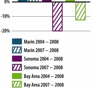
Summary

36              lanes). These HOV lanes would be installed in the median of US 101 and
37              directly connect to proposed HOV lanes south of the project limits near the
38              SR 37 Interchange and to proposed HOV lanes to the north beginning at Old
39              Redwood Highway in the City of Petaluma;

40          •   Widening and realigning US 101 in Segment B (the Central Segment) along
41              the Novato Narrows, which makes up 13.1 km (8.1 mi) of the entire project
42              boundaries. This would result in converting the existing expressway to an
43              access-controlled freeway. Access would be available through new
44              interchanges and existing local roads, which would be reconfigured to connect
45              to new interchanges in this segment.

46          •   Replacing bridges and constructing new bridges across San Antonio Creek
47              and replacing the Petaluma River Bridge;

48          •   Constructing soundwalls along Segment A (the Southern Segment) and
49              Segment C (the Northern Segment);

50          •   Constructing bicycle and pedestrian paths within the Central Segment to
51              replace bicycle access that currently exists along the expressway shoulder; and

52          •   Upgrading drainage facilities.

53          Together, these improvements comprise the proposed project. The project is
54          discussed as three segments because each has distinctive land use and
55          environmental settings. Specific transportation improvements also correspond to
56          these different segments (see Figure S-1):

57          •   Segment A (the Southern Segment) extends from just south of SR 37 to north
58              of Atherton Avenue in the City of Novato;

59          •   Segment B (the Central Segment) extends from Atherton Avenue Interchange
60              to south of SR 116 (East), crossing the Marin-Sonoma county line; and

61          •   Segment C (the Northern Segment) covers SR 116 (East) to north of the
62              Corona Overcrossing in the City of Petaluma.

63   S.2    Why is this project needed?
64          The need to make improvements to US 101 has been documented in many
65          transportation plans and studies by Marin and Sonoma counties individually, and

     Marin-Sonoma Narrows HOV Widening Project FEIR/S                                       S-3
Summary

 66          by regional and state agencies such as the Metropolitan Transportation
 67          Commission (MTC) and Caltrans. In establishing the project boundaries, Caltrans
 68          defined rational, logical starting and ending points and ensured that the
 69          improvements would stand on their own and provide benefits to the public (see
 70          Chapter 1 for further details about the project boundaries). In other words, the
 71          improvements do not depend on other modifications to US 101 to offer
 72          congestion relief and operational improvements along this stretch of US 101.

 73          A number of circumstances underscore the need for the MSN Project. Highlighted
 74          below are the principal reasons why this project is being proposed.

 75          Existing Congestion. Recent monitoring by Caltrans reveals travel delays
 76          experienced by daily commuters along this stretch of US 101. Over the last 15
 77          years, significant commercial and
 78          residential growth, along with           Figure S-2 Change in Vehicles Hours
                                                              of Delay on Freeway
 79          expansion of the tourism industry,
 80          has led to a dramatic increase in
 81          travel demand along the corridor.
 82          US 101 is a crucial link for
 83          commuters and commerce,
 84          connecting the vital business
 85          centers of San Francisco and the
 86          East Bay with Marin, Sonoma, and
 87          the North Coast. According to
 88          MTC’s Transportation 2030 Plan
 89          for the San Francisco Bay Area
 90          (2005), the narrow segment
 91          between Marin and Sonoma
 92          counties is one of the longest,
 93          continuously congested bottlenecks
 94          for truck traffic in the entire Bay
 95          Area.

 96          The following discussion is based
 97          upon the Daily (Morning and
 98          Evening Peak-Period) Freeway
 99          Delay by Bay Area County, 2004-
100          2008 that can be found at

      Marin-Sonoma Narrows HOV Widening Project FEIR/S                                       S-4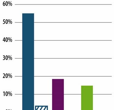
Summary
101 www.mtc.ca.gov/news/congestion/: There is an upward trend in vehicle hours of
102 delay (VHD) in the Bay Area that is more pronounced in Marin and Sonoma
103 counties. For instance, VHD increased in the Bay Area by 30 percent between
104 2004 and 2007. In Marin during this same period, VHD increased by 51 percent
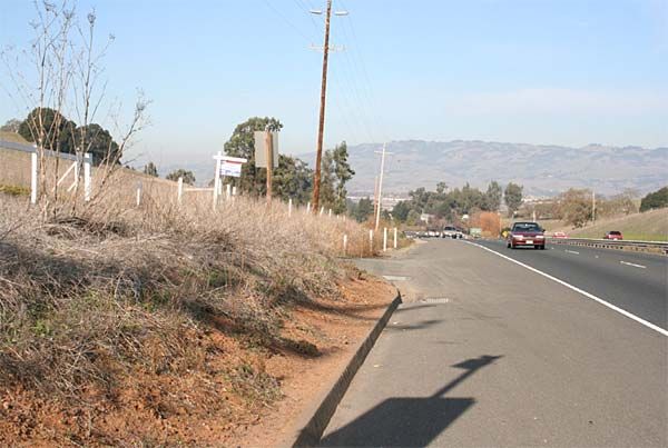
105 and by 49 percent in Sonoma.
106 More recently, the monitoring data shows that from 2007-2008 VHD was
107 reduced, attributable to the economic downturn. Despite decreases of 12 percent
108 for the Bay Area and 20 percent in Sonoma County, Marin County recorded a
109 3 percent increase (Figure S-2).
110 These decreases mute the effect of two major segments of the MSN Project limits
111 that were among the top 50 most congested freeway locations in 2008 according
112 to MTC. Number 21 was Sonoma 101 southbound from East Washington to
113 Kastania Road in the AM peak period with 1880 VHD. Number 47 was Marin
114 101 northbound from De Long to South of Petaluma during PM peak period with
115 960 VHD (Top 50 Congested Locations 2008—Ordered by Rank, Caltrans and
116 MTC).
117 Despite the economic downturn, the Bay Area, Marin, and Sonoma counties have
118 experienced increases in VHD of 15, 55, and 19 percent, respectively, between
119 2004-2008 (Figure S-2). Reported decreases in VHD have been attributed to
120 lowered employment (California Employment Development Department,
121 Caltrans, MTC, Vehicle Hours of Delay vs. Employment San Francisco Bay
122 Area, 1999-2008). The strong relationship between employment and VHD is
123 evidence that congestion reduction would be even more dire once the economy
124 and employment rebound.
125 Future Congestion. With congestion and hours of vehicle delay already
126 substantial, future conditions are projected to become even worse. According to
127 Caltrans, vehicle delays on US 101 in the southbound direction during the A.M.
128 (morning) peak period are projected to increase about 50 percent between 2010
129 and 2030. In the northbound direction during the P.M. (afternoon/evening) peak
130 period, vehicle delays are projected to increase similarly over the same period
131 (Caltrans, 2005).
132 Operational Deficiencies. Similar to the Southern and Northern Segments, the
133 Central Segment is also congested during peak travel demand periods. However,
134 existing operational deficiencies along this the expressway facility worsen
Marin-Sonoma Narrows HOV Widening Project FEIR/S S-5Summary
135 congested conditions. Examples of these deficiencies are illustrated in Figure S-3
136 and described below:
137 • Local traffic movements compete with mainline commuter traffic to cross
138 US 101 along Segment B to access residential postal boxes or other low-
139 density land uses. Existing at-grade intersections and driveways with direct
140 access on either side of US 101 result in merging and exiting local traffic
141 during peak demand periods. The current expressway makes it difficult to
142 serve both mainline and local circulation needs;
143 • Shoulder widths do not meet current design standards and thus do not provide
144 adequate pull-out areas for disabled vehicles; and
145 • Upgrading roadway features, such as horizontal curves (turning radii) and
146 vertical curves (rate of incline and decline) would increase distant visibility of
147 upcoming hazards or changing traffic conditions.
148 • Portions of US 101 historically flood, because existing culverts are undersized
149 to handle current and predicted runoff during large storms.
150 Local Initiatives. A number of actions by public agencies have signaled support
151 for the MSN Project. Sonoma County elected to direct local funds, including
152 portions of its local sales tax measure (Measure M) passed in 2004, to support the
153 project. A chief directive by the local voters in the passage of these tax initiatives
154 was to improve mobility and reduce local congestion for everyone who lives or
155 works in the counties by providing a variety of high quality transportation options
156 designed to meet local needs. The support shown by each of these counties, in
157 part, resulted in the recommendation by the MTC to include this project as one of
158 the improvements that would enhance connectivity and safety. As a result, the
159 MSN Project was awarded funding through the Corridor Mobility Improvement
160 Account (CMIA) of the Highway Safety, Traffic Reduction, Air Quality, and Port
161 Security Bond Act of 2006 (Proposition 1B) that was passed by the California
162 voters in the November 2006 election.
163 S.3 Who has proposed this project?
164 The MSN Project is a joint project by Caltrans, District 4 and the Federal
165 Highway Administration (FHWA), and their local partners in Marin and
166 Sonoma counties. The local partner in Marin County, the Transportation
Marin-Sonoma Narrows HOV Widening Project FEIR/S S-6Summary
167 Figure S-3 Access Problems in the MSN Project Central Segment
168
169 Aerial view of open median
170
171 At-grade connection to US 101
172
173 At-grade connection to US 101
Marin-Sonoma Narrows HOV Widening Project FEIR/S S-7Summary
174 Authority of Marin (TAM), was created to administer the county’s local sales
175 tax Measure A, approved by the voters to support transportation projects in the
176 county. The local partner in Sonoma County, the Sonoma County
177 Transportation Authority (SCTA), was created to serve as the countywide
178 planning and programming agency for transportation-related issues. Each of these
179 local partners has collaborated with Caltrans and FHWA throughout the
180 development of the project, sought funding for the project, and been vocal project
181 advocates in their roles as transportation experts and spokespersons within the
182 counties. Subsequent to a letter dated November 27, 2007, from the US Coast
183 Guard (USCG) requesting to serve as a cooperating agency on the environmental
184 document, FHWA has agreed to the agency’s participation in this role
185 (Appendix B). FHWA followed up with a letter formalizing the request on May
186 13, 2008 (see Appendix Q). On June 29, 2009, Melanie Brent communicated with
187 USCG to confirm their acceptance of cooperating agency status (personal
188 conversation Carl Hauser, USCG, Eleventh Coast Guard District, 6/29/09). This
189 role will help to streamline the permit process for the Petaluma River Bridge over
190 which the USCG has jurisdiction.
191 S.4 What is an EIR/EIS?
192 An Environmental Impact Report (EIR) is a document prepared pursuant to the
193 California Environmental Quality Act (CEQA). Under CEQA, an EIR describes:
194 • the proposed project;
195 • the possible impacts of the project (particularly those considered
196 “significant”) on the physical environment;
197 • measures to reduce or eliminate identified significant impacts; and
198 • possible alternatives that could achieve the project’s objectives and minimize
199 some of the significant impacts.
200 The “lead agency” (the public agency with primary approval responsibility for the
201 project) preparing the EIR for the MSN Project is Caltrans.
202 An Environmental Impact Statement (EIS) is a document prepared pursuant to
203 the National Environmental Policy Act (NEPA). NEPA applies when a federal
204 action is proposed. Such actions include federal funding, building on federal land,
205 or issuing a federal permit. The EIS, like the EIR, is intended to describe:
Marin-Sonoma Narrows HOV Widening Project FEIR/S S-8Summary
206 • the proposed action and possible alternatives;
207 • the consequences of those alternatives on the biological, physical, and
208 socioeconomic environments; and
209 • measures to reduce or eliminate the impacts.
210 The federal lead agency preparing the EIS for the MSN Project is the FHWA.
211 Because the MSN Project is a joint project by Caltrans and FHWA, it is subject to
212 both state and federal environmental review requirements. Accordingly, the
213 environmental analysis and documentation has been prepared in compliance with
214 both CEQA and NEPA.
215 The Draft Environmental Impact Report/Environmental Impact Statement
216 (DEIR/S) was available for public review from October 16 to December 14, 2007.
217 Caltrans and FHWA have collected, reviewed, and responded to comments
218 submitted on the DEIR/S. These comments and responses are reported in
219 Volume 3 of this Final Environmental Impact Report/Final Environmental Impact
220 Statement (FEIR/S).
221 Caltrans and FHWA have also identified a Preferred Alternative. These efforts are
222 disclosed in this FEIR/S. Caltrans and FHWA have also coordinated and
223 consulted with state and federal agencies concerning the Preferred Alternative.
224 S.5 Who will use the FEIR/S?
225 Decision Makers. The lead agencies and their sponsoring partners must consider
226 the impacts identified in the FEIR/S prior to acting on the project. It may be that,
227 upon review of the FEIR/S, lead agencies decide to alter the proposed project or
228 to identify an alternative.
229 The Public. In addition, the FEIR/S is prepared for public review and comment.
230 In deliberating on the proposed project, the lead agencies will consider the
231 opinion and concerns about the desirability of a project and its consequences.
232 Thus, the FEIR/S allows the public to become more engaged in the review
233 process and to offer more informed comments on the project to the lead agencies.
234 Public Agencies with Review, Approval, and Permit Responsibilities. There
235 are a number of federal, state, regional, and local public agencies that have
Marin-Sonoma Narrows HOV Widening Project FEIR/S S-9Summary
236 jurisdiction over resources that may be affected by the MSN Project. These
237 agencies, listed below, will review the FEIR/S and use the analyses to understand
238 the potential impacts on the resources they oversee, to make discretionary
239 decisions on the project, or to exercise their review and permit authority over the
240 project. All of the permits and regulatory reviews must be completed prior to
241 construction.
242 • United States Fish and Wildlife Service (USFWS) – will review impacts of
243 sensitive biological species and habitats, in accordance with the federal
244 Endangered Species Act;
245 • California Department of Fish and Game (CDFG) – will review impacts on
246 streambed alteration, in accordance with Fish and Game Code, Section 1602;
247 and on sensitive biological species and habitats, in accordance with the
248 California Endangered Species Act;
249 • United States Army Corps of Engineers (USACE) – will review impacts on
250 fill or discharge to wetlands or waters of the U.S, in accordance with
251 Section 404 of the Clean Water Act (CWA) and Section 10 of the Rivers and
252 Harbors Appropriation Act of 1899. This project is being reviewed under the
253 NEPA/404 “Integration Memorandum of Understanding that seeks to
254 streamline the NEPA and Section 404 Clean Water Act Processes. Part of this
255 process is to determine the project’s “Least Environmentally Damaging
256 Practicable Alternative” (please see Chapter 6 Summary of Public/Agency
257 Involvement Process/Tribal Coordination for more information on this topic);
258 • Regional Water Quality Control Board (RWQCB) – will review impacts on
259 water quality standards, in accordance with Section 401 of the Clean Water
260 Act;
261 • California Public Utilities Commission (CPUC) – will review potential of
262 environmental impacts associated with the relocation of utility facilities
263 necessary for project construction;
264 • National Oceanic and Atmospheric Administration, Fisheries (NOAA
265 Fisheries) – will review effects on fish species and habitat, in accordance with
266 the Endangered Species Act;
Marin-Sonoma Narrows HOV Widening Project FEIR/S S-10Summary
267 • State Historic Preservation Officer (SHPO) – will review effects on historic
268 and prehistoric cultural resources, in accordance with the National Historic
269 Preservation Act (NHPA);
270 • State Lands Commission (SLC) – will review impacts on lands under the
271 public trust; and
272 • United States Coast Guard (USCG) – will review impacts on navigation and
273 safety, in accordance with the General Bridge Act of 1946, as amended. A
274 Clean Water Act Section 401 water quality certification must be issued or
275 waived before the USCG can issue a permit for the bridge.
276 S.6 Are there different ways of fixing the problems?
277 Prior to preparing the DEIR/S, Caltrans completed a study in May 2000, referred
278 to as Route 101 Marin-Sonoma Counties Major Investment Study,1 which
279 examined a range of alternatives to relieve congestion in the US 101 North Bay
280 Corridor. Subsequently, TAM and SCTA requested that Caltrans conduct more
281 detailed “Project Study Reports” to assist with programming and funding
282 improvements in the corridor. The Project Study Reports investigated widening
283 the existing facility for additional lanes, installing median barriers, widening
284 interchange ramps, installing ramp metering equipment, adding new interchanges,
285 correcting existing operational deficiencies, constructing access roads with
286 bicycle and pedestrian paths, and widening bridges. Each of these individual
287 improvements was important in fashioning the alternative packages of
288 improvements that are studied in this FEIR/S (as explained further below).
289 The MSN Project is included in the MTC’s Regional Transportation Plan (RTP),
290 Transportation 2030 Plan for the San Francisco Bay Area (2005), which looks at
291 multi-modal transportation improvement options throughout the bay area region.
292 The EIR created for the RTP (2005) determined that the Transportation 2030 Plan
293 should be selected over the No Build Alternative or the TRANSDEF Smart
1
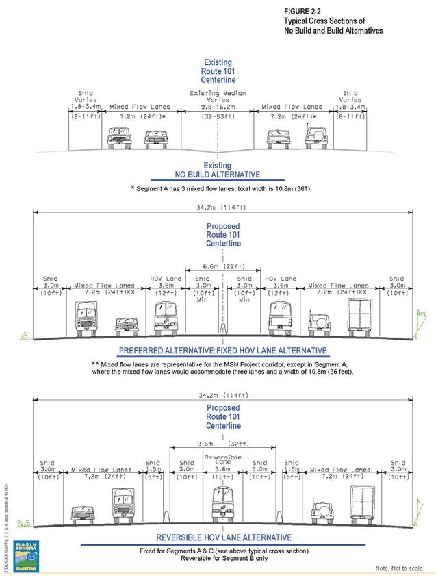
A Major Investment Study (MIS) is a comprehensive transportation planning study designed to identify
and address the mobility needs in a particular corridor. It is used when there is a potential for major
investment involving federal funds in the study area. The MIS proposes alternative sets of solutions;
screens out solutions deemed infeasible; requires that technical analyses be performed on remaining
solutions to determine their viability; and selects a preferred set of solutions. The MIS is an internal
document and not circulated to the public. For additional information, please refer to Volume 3,
Section 2.6.
Marin-Sonoma Narrows HOV Widening Project FEIR/S S-11Summary
294 Growth Alternative, as neither could provide the full transportation benefits that
295 would be achieved through the range of projects proposed in the Transportation
296 2030 Plan.
297 S.7 Who helped suggest ways to fix the problems?
298 Caltrans has conducted public outreach through public scoping meetings and by
299 forming a Policy Advisory Group to help develop alternatives that could be
300 studied as part of the FEIR/S. Public input was solicited during early scoping
301 meetings and through responses to public notices about Caltrans’ intent to prepare
302 an FEIR/S. The Mineta Transportation Institute convened a Regional
303 Transportation Hot Spot Forum dedicated to the Marin/Sonoma 101 Corridor in
304 April 2003. Representatives from the local jurisdictions, plus members of the
305 public, brainstormed on ideas and actions to relieve congestion. These ideas
306 further formed the solutions that Caltrans, its local partners, and the Policy
307 Advisory Group were discussing.
308 The Policy Advisory Group, composed of local city and county officials, served
309 as an advisory body to Caltrans, FHWA, TAM, and SCTA. In addition to policy
310 guidance, Caltrans obtained technical guidance from groups such as the local
311 public works officials; state and federal regulatory agencies; the Golden Gate
312 Bridge, Highway, and Transportation District; the California Highway Patrol; the
313 Sonoma Marin Area Rail Transit District; and a coalition of bicycle and
314 pedestrian groups.
315 S.8 What alternatives are studied in the FEIR/S?
316 As noted earlier, the package of improvements varies by each segment. For
317 Segments A and C, there are only two alternatives: “Build” or “No Build.” These
318 segments are already built to freeway standards, so the needed improvements are
319 not as extensive as in Segment B (Central Segment), which is currently built to
320 expressway standards and needs much more work. For Segment B, there are two
321 build alternatives, as well as four freeway access options under consideration. The
322 access options would work with either of the build alternatives. The alternatives
323 are generally described below and detailed in Chapter 2.
324 No Build Alternative. The No Build Alternative is the no-action alternative. The
325 No Build Alternative proposes no modifications to US 101 within the project
Marin-Sonoma Narrows HOV Widening Project FEIR/S S-12Summary
326 boundaries, other than routine maintenance and rehabilitation to support the
327 continuing operations of the existing roadway when needed.
328 Fixed HOV Lane Alternative. Under this alternative, two HOV lanes, one in
329 each direction, would be constructed in the median of US 101 for the length of the
330 MSN Project (26.0 km, or 16.1 mi). The HOV lanes would be restricted to
331 vehicles carrying two or more people during specific hours, usually during the
332 peak commute periods. Outside of these specified hours, the HOV lanes would be
333 available to all vehicles, regardless of the number of passengers.
334 The HOV lanes would have a standard width of 3.6 meters (m), or 12 feet (ft),
335 plus shoulders in the median that would allow vehicles to pull over if disabled or
336 to let an emergency vehicle pass. A median barrier would be installed to separate
337 the northbound and southbound lanes of traffic.
338 Reversible HOV Lane Alternative. This alternative is exactly the same as the
339 previously described alternative for Segment A (from SR 37 to north of Atherton
340 Avenue in Marin County) and Segment C (from SR 116 (East) to north of the
341 Corona Overcrossing in the City of Petaluma (Sonoma County); i.e., there would
342 be fixed HOV lanes, one in each direction in the median of US 101. Within
343 Segment B (the Central Segment), a single reversible HOV lane would be
344 constructed in the median of US 101. The US 101 median within this segment
345 would be 9.6 m (32 ft) wide, which would provide sufficient room for the 3.6 m
346 (12 ft) reversible HOV lane and shoulders. On either side of this HOV lane,
347 barriers would separate the HOV lane from the existing “mixed flow” lanes. This
348 HOV lane would be 10.5 km (6.5 mi) in length.
349 The key difference with this “reversible” alternative is that the HOV lane in this
350 segment would only allow traffic in one direction, depending on the time of day.
351 During the A.M. peak period, only southbound traffic could use the HOV lane;
352 during the P.M. peak period, only northbound traffic could use the HOV lane.
353 This “reversible” concept allows the HOV lane to accommodate traffic flow
354 based on the predominant travel direction during the peak commute periods.
355 Figure S-4 shows a typical cross section across US 101 and highlights the
356 differences among the three alternatives. It is noted that the width of the cross
357 sections for the Fixed HOV Lane Alternative and the Reversible HOV Lane
358 Alternative are the same at 114 ft and have the same alignments.
Marin-Sonoma Narrows HOV Widening Project FEIR/S S-13Summary
359 Figure S-4 Typical Cross Sections of No Build and Build Alternatives
360
Marin-Sonoma Narrows HOV Widening Project FEIR/S S-14Summary
361 Other Improvements Common to the Build Alternatives. In addition to
362 widening the US 101 median to accommodate the HOV lanes that would enable
363 HOV traffic to flow continuously through the project boundaries, there are a
364 number of other improvements that would be constructed as part of either build
365 alternative. These features are noted below by segment.
366 • Segment A (the Southern Segment)
367 − Ramp metering and retaining walls at SR 37
368 − HOV bypass lanes at existing on-ramps
369 − Bridge widenings
370 − Sound walls and retaining walls
371 − Upgraded drainage facilities
372 − Speed changing lanes (aka auxiliary lanes)
373 • Segment B (the Central Segment)
374 − Roadway realignment
375 − Modifications to US 101 access roads (described separately below)
376 − Bicycle/pedestrian path
377 − Retaining walls
378 • Segment C (the Northern Segment)
379 − Ramp metering
380 − HOV bypass lane at existing on-ramps
381 − Bridge widening
382 − Soundwalls
383 − Retaining walls
384 − Upgraded drainage facilities
385 − Speed changing lanes (aka auxiliary lanes)
386 Access Options in Segment B (Central Segment). In addition to the roadway
387 realignment, the proposed freeway upgrade in Segment B (Central Segment)
388 would eliminate direct at-grade access to US 101. During the alternative
389 development phase, Caltrans identified 15 different packages of improvements to
390 maintain access to property owners in this segment, to serve Olompali State
391 Historic Park, to allow construction of a bicycle/pedestrian path, and to control
392 access to US 101 through construction of new interchanges.
393 These different options were evaluated, considering a variety of factors, and
394 ranked. The top four ranked access options are included in this FEIR/S. The
Marin-Sonoma Narrows HOV Widening Project FEIR/S S-15Summary
395 access options vary in their proposals for the Redwood Landfill Road
396 Overcrossing, a potential new interchange near the existing southerly San Antonio
397 Road intersection, and the location and extent of new access roads on either side
398 of US 101.
399 S.9 Identification of the Preferred Alternative for Marin-Sonoma Narrows
400 (MSN) HOV Widening Project
401 Caltrans and FHWA have identified the Fixed HOV Lane Alternative as the
402 Preferred Alternative. The following is a summary of the reasons behind
403 identifying this alternative.
404 • While both alternatives are projected to provide similar throughput (the
405 number of vehicles passing through a given stretch of road) in the
406 predominant peak direction (a.m. southbound and p.m. northbound), the Fixed
407 HOV Lane Alternative would be available during all periods, while the
408 Reversible HOV Lane would be closed during off-peak periods. The Fixed
409 HOV Lane Alternative would be compatible with Marin County’s city-
410 centered corridor and Sonoma County’s city-centered growth policies.
411 • The Fixed HOV Lane Alternative would be more efficient than retrofitting the
412 Reversible HOV Lane to a Fixed HOV Lane in the future. Availability during
413 off-peak periods would be important for potential job and population growth
414 within Marin and Sonoma counties, which would be available with the Fixed
415 HOV Lane Alternative.
416 • The Reversible HOV Lane would require switching devices, safety devices,
417 and message signs. More monitoring and staff would be needed to operate the
418 Reversible HOV Lane Alternative, making it a more costly system to operate
419 and maintain.
420 • Removing disabled vehicles from the HOV Lane and providing emergency
421 vehicle access along US 101 would be more difficult with the Reversible
422 HOV Lane Alternative because of the limited access to the center HOV Lane.
423 • The Fixed HOV Lane Alternative at $429.7 would be more cost effective.
424 According to the MSN Project Report, the total estimated construction cost for
425 the Fixed HOV Lane Alternative would be $2.4 million less than the
426 Reversible HOV Lane Alternative million (not including support costs). The
Marin-Sonoma Narrows HOV Widening Project FEIR/S S-16Summary
427 totals displayed reflect the total estimated costs with the preferred Access
428 Option 12b; which is discussed in the following paragraphs.
429 Although any of the Access Options would be compatible with either mainline
430 alternative, Caltrans and FHWA have identified Access Option 12b. The
431 following is a summary of the reasons behind identifying Access Option 12b over
432 the others:
433 • Although all the access options would result in similar adverse visual impacts
434 to motorists, bicyclists, and pedestrians, Access Option 12b will be less
435 visually intrusive because of the utilization of existing interchanges rather
436 than building new larger interchanges. Thus, a high level of visual quality will
437 be maintained with Access Option 12b; in which scenic view corridors of
438 hillsides will provide a predominantly natural visual appearance.
439 • Access Option 12b will also take advantage of existing interchanges reducing
440 the projects footprint and conserving more right-of-way over the other
441 proposals.
442 • Access Option 12b would provide direct access to US 101 from the Redwood
443 Landfill, which generates more traffic compared to the other surrounding low-
444 density land uses.
445 • According to Caltrans Project Report, the total estimated construction cost of
446 the Access Options all within 5 percent of each other. Therefore, cost was not
447 as important compared to other considerations.
448 At its meeting on February 18, 2008, the Project Advisory Group (PAG) and the
449 Project Leadership Team (PLT), which includes Transportation Authority of
450 Marin (TAM) and Sonoma County Transportation Authority (SCTA), accepted
451 the recommendation of the Fixed HOV Lane Alternative with Access Option 12b
452 as the Preferred Alternative. Caltrans and FHWA have also identified this
453 Preferred Alternative as the Preliminary Least Environmentally Damaging
454 Preferred Alternative (LEDPA). Caltrans and FHWA have also received
455 concurrence from the participating NEPA/404 regulatory agencies on the
456 identification of the Fixed HOV Lane Alternative as the Preliminary LEDPA.
Marin-Sonoma Narrows HOV Widening Project FEIR/S S-17Summary
457 S.10 What are the consequences of building this project?
458 This FEIR/S describes the potential impacts associated with each of the
459 alternatives. It should be noted that there are differences between CEQA and
460 NEPA. A key distinction is in determining the “magnitude,” or severity, of an
461 impact. NEPA acknowledges adverse effects and recommends consideration of
462 mitigation measures to reduce the effects. CEQA emphasizes adverse effects that
463 are considered “significant” or “substantial” in that they exceed defined criteria.
464 If an impact is declared significant under CEQA, mitigation measures must be
465 identified.
466 During the scoping and alternatives development process, concerns arose
467 regarding the environmental sensitivity of the corridor, particularly in relation to
468 Segment B. Figures S-5a-d provides an overview to some of the major biological
469 resources in the MSN Project area. During the Access Options evaluation process
470 in Segment B, the Caltrans sought to avoid impacts to various environmental
471 resources. Nevertheless, some of these resources would be impacted should the
472 project be constructed, and these potential impacts are highlighted in Table S-3 at
473 the end of the Summary.
474 It is important to note that the widths of the cross sections for the two Build
475 Alternatives and their alignments are the same. Therefore the area taken up by the
476 freeway improvements (also known as the “footprints”) are the same.
477 Consequently, the impacts of the Build Alternatives on resources like cultural,
478 geology, and hydrology do not differ. Similarly, exposure to potential hazards like
479 noise, air emissions, and hazardous materials would also be identical. However,
480 the primary difference between the two Build Alternatives is their effect on traffic
481 and circulation. In contrast, there are more differences in impacts among the
482 Access Options associated with the expressway to freeway upgrade proposed in
483 Segment B.
484 Table S-2, at the end of this Summary, describes the impacts for each of the
485 alternatives, as well as the mitigation measures proposed to minimize adverse
486 impacts. Some of the key impacts are noted below by alternative.
487 No Build Alternative. The No Build Alternative proposes no modifications to
488 US 101 within the project boundaries other than routine maintenance and
489 rehabilitation to support the continuing operations of the existing freeway when
Marin-Sonoma Narrows HOV Widening Project FEIR/S S-18FIGURE S-5a
END OF SEGMENT A Biological Resources in the MSN Project Area
US 101 SEGMENT A: The Southern Segment
PETALUMA MARSH
WILDLIFE PRESERVE
SAN MARIN DR. RUSH CREEK LEGEND
Waters of the U.S.
ATHERTON AVE. (including wetlands)
RUSH CREEK Wildlife preserve and ponds
OPEN SPACE
PRESERVE
REDWOOD BLVD. Bay-oak woodlands
Waterways
Low-quality habitat; predominantly
urbanized
Medium-quality habitat; partially urbanized
with portions/stretches of natural habitat
DE LONG AVE.
High-quality habitat; predominantly natural
Fish habitat
Pickleweed
NOVATO
COMMUNITY
HOSPITAL
NOVATO CREEK
ROWLAND BLVD.
VINTAGE OAKS
SHOPPING CENTER
SCOTTSDALE POND
EHRETH POND
WILDLIFE PRESERVE
SMART LINE
REDWOOD BLVD.
SR 37
BEGIN PROJECT
TB042006002BAO_MSN_basemaps_BiologicalResources.indd 10-11-07
Note: Not to ScaleFIGURE S-5b
SAN ANTONIO CREEK Biological Resources in the MSN Project Area
SEGMENT B: The Central Segment
MATCHLINE (to County line)
SONOMA
COUNTY LINE
MARIN
COUNTY LINE
SAN ANTONIO
RD.
NOVATO RD.
REDWOOD LANDFILL RD.
BLIND-ENDED
DAIRY TIDAL CHANNEL
REDWOOD
LEGEND LANDFILL
Waters of the U.S. SMART LINE
(including wetlands)
Wildlife preserve and ponds
Bay-oak woodlands
OLOMPALI STATE
HISTORIC PARK
Waterways MIRA MONTE
MARINA RD.
Low-quality habitat; predominantly
urbanized
Medium-quality habitat; partially urbanized
with portions/stretches of natural habitat
High-quality habitat; predominantly natural
Fish habitat
Pickleweed
AIRPORT
BLVD.
BIRKENSTOCK WAREHOUSE
REDWOOD BLVD.
BINFORD
TB042006002BAO_MSN_basemaps.indd 10-09-07
RD.
BEGIN SEGMENT B
US 101
Note: Not to ScaleFIGURE S-5c
Biological Resources in the MSN Project Area
SEGMENT B: The Central Segment
(from County line)
PETALUMA MARINA
BEGIN SEGMENT C
PETALUMA RIVER
S. PETALUMA BLVD.
QUARRY
SMART LINE
LEGEND
Waters of the U.S. KASTANIA RD.
(including wetlands)
Wildlife preserve and ponds
GAMBINI RD.
Bay-oak woodlands
Waterways
Low-quality habitat; predominantly
urbanized
Medium-quality habitat; partially urbanized
with portions/stretches of natural habitat
High-quality habitat; predominantly natural
Fish habitat CLOUD (GUNN) LN.
Heron and Egret Rookery
Pickleweed
Riparian areas SKINNER RD.
SAN ANTONIO CREEK
TB042006002BAO_MSN_basemaps_BiologicalResources.indd 12-29-08
MATCHLINE
SAN ANTONIO RD.
SONOMA COUNTY LINE
MARIN COUNTY LINE
US 101
Note: Not to ScaleFIGURE S-5d
Biological Resources in the MSN Project Area
SEGMENT C: The Northern Segment
PETALUMA RIVER
END PROJECT
US 101
CORONA RD.
CORONA CREEK
N. McDOWELL BLVD.
CAPRI CREEK
SMART LINE
N. PETALUMA RD.
LYNCH CREEK
PETALUMA
FACTORY
OUTLET
E. WASHINGTON ST.
PETALUMA RIVER
LEGEND
E. WASHINGTON CREEK
Waters of the U.S.
(including wetlands)
Wildlife preserve and ponds
SONOMA-MARIN
Bay-oak woodlands FAIRGROUNDS
Waterways
CAULFIELD LN.
Low-quality habitat; predominantly
urbanized
Medium-quality habitat; partially urbanized
with portions/stretches of natural habitat
High-quality habitat; predominantly natural SMART LINE
Fish habitat
TB042006002BAO_MSN_basemaps_BiologicalResources.indd 10-11-07
Pickleweed BEGIN SEGMENT C
US 101
SR 116 / LAKEVILLE HIGHWAY
Note: Not to ScaleSummary
498 needed. As such, this alternative would produce no immediate environmental
499 impacts; and, consequently, no mitigation measures would be required.
500 Build Alternatives. Both the Fixed HOV Lane Alternative and the Reversible
501 HOV Lane Alternative involve impacts to the physical environment. During the
502 alternatives development process, Caltrans and FHWA sought to avoid or
503 minimize potential impacts as much as possible. However, complete avoidance of
504 impacts was not possible. Some of the impacts, including temporary impacts, for
505 both Build Alternatives are identified below. A complete listing of impacts is
506 contained in Table S-2:
507 • displacement of one residential unit because of the additional right-of-way
508 required;
509 • conversion of agricultural lands because of the additional right-of-way and
510 realignment of the roadway through Segment B;
511 • disturbance to archeological resources because of roadway and bridge
512 construction;
513 • disturbance to biological resources including trees and bird habitat, wetlands,
514 other Waters of the US, and habitat of sensitive wildlife and rare plant species
515 known to occur in the area, because of additional right-of-way and
516 realignment of the roadway through Segment B;
517 • alteration to the visual setting because of the increased views of roadways and
518 soundwalls, modifications to major landforms, and vegetation removal;
519 • light and glare on nearby residents because of vegetation removal;
520 • increased runoff and potential water quality degradation because of additional
521 impervious surfaces and stormwater pollutant loading on the roadway
522 surfaces; and
523 • construction impacts including traffic delays, temporary detours to the
524 Olompali SHP entrance, relocation of utility lines in the Caltrans right-of-way,
525 temporary closure of parking facilities, temporary disruption to transit
526 services, prolonged views of unsightly construction equipment, increased
527 erosion and sedimentation, exposure to hazardous materials or contaminated
Marin-Sonoma Narrows HOV Widening Project FEIR/S S-23Summary
528 soils or ground water, air and noise emissions, and disturbance to biological
529 resources and habitats.
530 The MSN Project will provide the following positive benefits to traffic,
531 infrastructure and energy efficiency, air quality, and the environment:
532 Traffic:
533 • Reduces congestion along US 101; thereby improving mobility for motorists
534 who use US 101 for home-to-work trips, tourism and recreational trips;
535 • Improves mobility for goods movement to support the region’s economic
536 vitality.
537 • Improves efficiency of system to provide less incentive for traffic to bypass
538 US 101 via local streets and roads.
539 • Increases highway system reliability for all users, including express bus
540 services and carpoolers, providing incentives for alternatives to Single
541 Occupancy Vehicle (SOV) commuting.
542 Infrastructure and Energy Efficiency:
543 • Standardizes horizontal and vertical curves, sight distances, and roadway
544 shoulders, thereby improving overall traffic operations, particularly during
545 peak travel demand;
546 • Corrects existing drainage problems and reduce roadway flooding,
547 • Improves efficient use of the existing roadway system without adding
548 substantial new capacity, which is in conformity with the local general plans;
549 • Upgrades Segment B (the Novato Narrows) from expressway to full freeway,
550 conforming to freeways in Segments A and C.
551 • Will retain and incorporate large portions of the existing US 101 roadway,
552 optimizing right of way and reducing land use conversion.
553 • Reduces vehicles miles traveled (VMT) and promote more efficient energy
554 consumption through system reliability.
Marin-Sonoma Narrows HOV Widening Project FEIR/S S-24Summary
555 Air Quality:
556 • In conformity with the Metropolitan Transportation Commission’s 2035
557 Regional Transportation Plan, implements the State Implementation Plan for
558 improving regional air quality and meets project-level attainment
559 requirements for CO, NO2, O3, and particulate matter.
560 • Implements construction of carpool/express bus lanes on freeways, also
561 known as Transportation Control Measure 8 of the Bay Area Air Quality
562 Management District 2000 Clean Air Plan to achieve air quality standards.
563 Environmental:
564 • Provides Class 1 and 2 bicycle lanes from northern Novato to southern
565 Petaluma.
566 • Provides freespan bridge structures over waterways to reduce structural
567 intrusions in fish and wildlife habitat areas.
568 • Provides up to 5 decibels in noise abatement to 168 homes within the project
569 area.
570 • Increases storm water treatment for freeway runoff.
571 • In conformity with city and county land use and growth policies, limits
572 frontage road construction.
573 The analysis of impacts, which is contained in Chapter 3 of this FEIR/S, also
574 describes the varying effects of the four Access Options. A summary of some of
575 the impacts by Access Option is provided in Table S-3.
576 S.11 Are there ways to reduce these adverse consequences?
577 The FEIR/S is required to identify measures to minimize or reduce impacts that
578 would result from building a project. The proposed measures in this FEIR/S
579 would minimize or reduce identified adverse impacts, and, in some cases, replace
580 disturbed resources.
581 During the construction period, there are a number of existing regulations that
582 define standard practices, procedures, and “best management practices” (BMPs).
583 These regulations and a menu of standard practices are effective at minimizing the
584 effects of air emissions, erosion and sedimentation, noise, disturbance to cultural
Marin-Sonoma Narrows HOV Widening Project FEIR/S S-25Summary
585 and biological resources, geologic hazards, and exposure to hazardous materials
586 from construction activities. In addition, there are established management plans
587 that Caltrans prepares to ensure that traffic disruption and safety hazards are
588 minimized during the construction of roadway and bridge improvements. Such
589 plans address traffic detours, signage, hours of construction, and other practices
590 and procedures to ensure the safety of the construction workers and the public and
591 to minimize the amount and duration of disruption to circulation and access.
592 For permanent impacts that may result from the Build Alternatives, there are other
593 measures that can reduce the severity of the potential impacts. For example:
594 • for displacement of homes, there are state and federal programs to assist with
595 relocation;
596 • for loss of archeological resources, there are requirements of the SHPO that
597 define methods for data recovery and recordation;
598 • for loss of biological resources, there are requirements and permits that define
599 compensation for harm under the supervision of USFWS, USACE, NOAA,
600 CDFG, and other agencies;
601 • for noise, soundwalls can be constructed to protect residential areas, and other
602 sensitive noise receptors; and
603 • for excessive light and glare, landscaping and screening can shield viewers.
604 With the implementation of these measures, it is anticipated that all adverse
605 effects would be sufficiently addressed, except for the alteration to the visual
606 setting. In other words, in spite of all avoidance, minimization and mitigation
607 measures, construction of the Build Alternatives could result in substantial
608 permanent visual effects.
609 S.12 Is there any controversy over building the project?
610 The MSN Project would involve disturbance to a number of sensitive
611 environmental resources, some of which are illustrated in Figures S-5a-d. The
612 Policy Advisory Group, the public, and the resource agencies have expressed
613 concern over disturbance to archeological resources, potential loss of wetlands
614 and habitat for threatened and endangered species, and trees. Similarly, the Hot
615 Spot Forum that was sponsored by the Mineta Institute echoed concerns over
Marin-Sonoma Narrows HOV Widening Project FEIR/S S-26Summary
616 disturbance to the natural resources. The overarching recommendation emerging
617 from the forum was the need to take a “modest approach that protects baylands,”
618 rather than a buildout solution that would transform the unique neighboring
619 communities to look like other communities, with access roads on either side and
620 multiple interchanges.
621 Changes to the visual setting, particularly in the Central Segment, which is largely
622 rural and undeveloped, are a cause for concern. The construction of roadways,
623 interchanges, and retaining walls could diminish open space sceneries and views
624 of major landforms and trees.
625 In the urban areas of the project, issues over the likelihood of increased noise
626 pollution have been raised. Nearby residents have requested the construction of
627 soundwalls, in addition to the ones currently proposed.
628 Realignment of the US 101 mainline the Central Segment would involve the
629 construction of new interchanges and overcrossings. The controlled access
630 provided at selected locations in this stretch of US 101 raises concerns about
631 growth inducement and attracting new, more urbanized land uses, not reflective of
632 the predominantly rural land use character of the Central Segment.
633 The disturbance to natural resources, the loss of the natural rural setting, and the
634 fear of unwanted growth are all concerns that have been raised by the public. As a
635 result, there have been calls for traffic congestion relief solutions that rely less on
636 roads and more on transit opportunities. Specifically, there is a belief among some
637 groups that public funds would be better invested in transit and commuter rail
638 services.
639 The inclusion of pedestrian/bicycle access ways in the project has been mentioned
640 in reference to pedestrian and bicyclist safety concerns. With the addition of bike
641 paths throughout the Central Segment, maintaining pedestrian and bicyclist safety
642 is a main concern and ties into issues of maintenance, access and separation from
643 traffic.
644 In light of the above, a resolution has been made as to which alternative and
645 which Access Option would best accomplish the project purpose and satisfy the
646 identified needs in this portion of the US 101 corridor. Also, as noted earlier in
647 the description of how this joint document will be used, there are other public
648 agencies that will use this report to make regulatory and permitting
Marin-Sonoma Narrows HOV Widening Project FEIR/S S-27Summary
649 determinations. Caltrans and FHWA have taken the public’s and regulator’s
650 comments into consideration in the identification of a Preferred Alternative.
651 S.13 Are there other transportation projects underway?
652 The MSN Project is one of a number of transportation improvements that are
653 under consideration or construction in the project area. These related projects are
654 shown in Figure S-6 and summarized from south to north in Table S-1.
655 S.14 What are the next steps?
656 There are several key steps to complete the environmental review process, and.
657 these steps are summarized below.
658 Public Review and Comment. In accordance with CEQA and NEPA, Caltrans
659 and FHWA distributed the DEIR/S and received public comments from October
660 16, 2007, to December 14, 2007, from many public agencies, interested
661 organizations, and interested members of the public. Additionally, meetings were
662 held where the public could ask questions, view design display boards and visual
663 simulations, and provide comments on the DEIR/S. The public meeting
664 announcement and notices of availability appeared in local newspapers (see
665 Chapter 6 for proofs of publication) and all individuals and organizations on the
666 project mailing list were notified. The comments received and their responses are
667 presented in Volume 3 of this FEIR/S.
668 Some of the Comments addressed include, but are not limited to:
669 • the merits of the alternatives;
670 • preferences for a particular alternative or variant; the accuracy of the
671 description of existing environmental baseline conditions;
672 • the sufficiency of the document at identifying impacts;
673 • suggestions for other impacts to consider;
674 • the adequacy of the identified mitigation measures; and
675 • suggestions for other mitigation measures to consider.
Marin-Sonoma Narrows HOV Widening Project FEIR/S S-28Summary
676 Figure S-6 Related Projects in MSN Study Area
677
Marin-Sonoma Narrows HOV Widening Project FEIR/S S-29Summary
678 In accordance with CEQA, a Notice of Determination will be filed with the State
679 Clearinghouse. Under NEPA, however, FHWA needs to approve the Preferred
680 Alternative through a Record of Decision (ROD) in which the rationale for
681 identifying the Preferred Alternative is discussed and substantive comments are
682 addressed. After approval of the ROD, this project can proceed to final design and
683 construction.
684 Identification of a Preferred Alternative. Based on public comments received
685 on the DEIR/S and federal and state requirements, Caltrans and FHWA identified
686 a Preferred Alternative that is still subject to further design and refinement. In
687 making this decision, FHWA and Caltrans, consulted with regulatory agencies
688 through the NEPA/404 process (see Section 6.3.1), and with its local partners,
689 TAM and SCTA. These consultations led to the determination that the Preferred
690 Alternative would also serve as the Preliminary LEDPA.
691 Preparation of the FEIR/S. Caltrans and FHWA reviewed all of the comments
692 received on the DEIR/S. Responses to these comments have been prepared and
693 are presented in Volume 3 of this FEIR/S. Updates and changes have been made
694 to the environmental document where appropriate. This FEIR/S also identifies the
695 Preferred Alternative.
696 Approval of the FEIR/S. The FEIR/S will be distributed to agencies,
697 organizations, and individuals who commented on the DEIR/S. The FEIR/S will
698 inform those commenting on the DEIR/S how their comments were addressed and
699 what changes may have been made to the project.
700 To complete the FEIR/S documentation, Caltrans would approve or “certify” that
701 the document complies with CEQA and FHWA would approve the document
702 under NEPA.
703 Decision on the Project. Only after formal approval can federal and state
704 agencies take action on the MSN Project. In accordance with CEQA, Caltrans
705 would issue a Notice of Determination (NOD) that identifies the decision to
706 certify the FEIR/S. In accordance with NEPA, FHWA would issue and publish a
707 Record of Decision (ROD) identifying the Preferred Alternative and approving
708 the project. The Preferred Alternative would then advance to the design stage and
709 be constructed based on available funding.
Marin-Sonoma Narrows HOV Widening Project FEIR/S S-30Summary
710 Phase 1 of the Project. Currently, Phase 1 of the project has been identified and
711 construction will begin in late 2010. The scope of work under Phase 1 was
712 constrained by the available funding. The Phase 1 improvements were identified
713 to extend the existing HOV lanes in Novato northward while also addressing the
714 access issues in Segment B. The Phase 1 proposed improvements include
715 constructing a northbound and southbound HOV lane in Segment A between
716 SR 37 and north of Rowland Boulevard, and a northbound HOV lane between
717 north of Rowland to north of Atherton Avenue. Also in Segment A, sound walls
718 will be constructed and the existing on-ramps will be widened for an HOV bypass
719 lane and ramp meters installed. In Segment B, the Petaluma Boulevard South
720 Interchange will be reconstructed and the Redwood Landfill Overcrossing will be
721 converted into an interchange. A portion of US 101 would be reconstructed to
722 correct nonstandard roadway geometry and inadequate drainage. A portion of the
723 proposed frontage road network will be constructed. A continuous bike path
724 through Segment B would also be constructed. The Phase 1 improvements in
725 Segment B will allow the closure of 27 of the existing 37 access points along
726 US 101.
727 Phase 2 of the Project. Phase 2 of the Project would construct a southbound
728 HOV lane in Novato between north of Rowland Boulevard to north of Atherton
729 Avenue by widening the existing median. Between north of Atherton Avenue and
730 north of the North Novato Overhead, a northbound and a southbound HOV lane
731 would be constructed by widening within the existing median. Between north of
732 the North Novato Overhead and the Petaluma River Bridge, US 101 would be
733 widened and realigned to provide an HOV lane in both directions while correcting
734 nonstandard roadway geometry in Segment B. In the City of Petaluma, the
735 Petaluma River Bridge would be replaced with a wider structure and US 101
736 would be widened to provide an HOV lane in each direction. Both inside and
737 outside widening would be done to accommodate the additional lanes. The new
738 HOV lanes would terminate south of the Old Redwood Highway Interchange, or
739 tie into planned HOV lanes to the north, if that project is constructed first. The
740 roadway north and south of the North Petaluma Overhead would be reconstructed
741 to improve sight distance. Existing on-ramps at the SR 116 and East Washington
742 Interchanges would be widened to provide an HOV bypass lane and ramp meters
743 installed. Sound walls would be constructed in Petaluma. Phase 2 will close the
744 remaining uncontrolled access points within the MSN Project boundaries.
Marin-Sonoma Narrows HOV Widening Project FEIR/S S-31You can also read