Maritime Archaeological Survey - EMU 1874 1888 - HERITAGE BRANCH
←
→
Page content transcription
If your browser does not render page correctly, please read the page content below
EMU 1874 - 1888
       Maritime Archaeological Survey
Report into the exposed shipwreck remains located at Crowdy Bay, NSW.

HERITAGE BRANCH
DEPARTMENT OF PLANNING
SYDNEY, 1994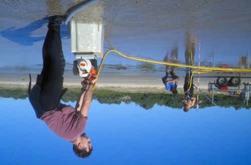
Report prepared by: David Nutley and Tim Smith
CONTENTS
INTRODUCTION...................................................................................................................4
HISTORICAL CONTEXT .......................................................................................................5
Emu Wreck - Construction Details. ....................................................................................8
OBJECTIVES........................................................................................................................9
General..............................................................................................................................9
Specific..............................................................................................................................9
METHODOLOGY ..................................................................................................................9
Wreck Site Location ............................................................................................................11
Wreck Inspection.................................................................................................................12
ENVIRONMENTAL DESCRIPTION.....................................................................................13
Wreck Site Description.....................................................................................................13
ASSESSMENT OF SIGNIFICANCE....................................................................................15
STATEMENT OF SIGNIFICANCE ...................................................................................16
RECOMMENDATIONS .......................................................................................................16
Figure 1: Painting of SS Emu by William Forster.......................................................6
Figure 2: Original photograph of the SS Emu.. ..........................................................8
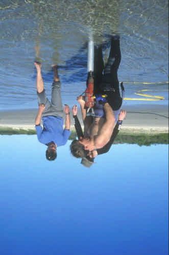
Figure 3: Tim Smith operating water pump for probe survey ...................................10
Figure 4: Extracting core sample of timber from inside aluminium pipe ...................11
Figure 5: Location map showing the position of wreck remains on Crowdy Beach..14
Figure 6: Photograph of exposed engine.................................................................14
Figure 7: Photograph of exposed boiler...................................................................14
Figure 8: Predictive plan showing extent of buried structure.. .................................14
Figure 9: Results of probe survey, showing all probe refusals.................................15
Table 1: Steamer wrecks attributed to crowdy beach ................................................5
Table 2: Sailing vessel wrecks attributed to crowdy beach ........................................6
Cover: Predictive plan showing the exposed remains and the likely extent of
buried structure. Proposed by Mr John Riley. (Drawing by Tim Smith)
Report Prepared: 1994.
© Heritage Branch, Department of Planning, Sydney, AUSTRALIA
The material contained within may be quoted with appropriate attribution.
Disclaimer
Any representation, statement, opinion or advice, expressed or implied in this publication is
made in good faith but on the basis that the State of New South Wales, its agents and
employees are not liable (whether by reason of negligence, lack of care or otherwise) to any
person for any damage or loss whatsoever which has occurred or may occur in relation to
that person taking or not taking (as the case may be) action in respect of any representation,
statement or advice referred to above.
EMU (1874-1888)

                     WRECK INSPECTION REPORT

INTRODUCTION

This report details a survey of a partially buried shipwreck located on the beach
at Crowdy Bay, near Harrington NSW (Figure 1).

The Department of Planning enlisted Manly Hydraulics Laboratory (MHL) to
assist in the survey attempting to reveal the extent of the buried remains.
Periodically exposed during storm activity, the existence of the wreck has largely
been forgotten by the local community.

Much of the buried portion of the wreck site was traced with the aid of a probe
survey. While it has not been possible to fully establish the identity of the
vessel, the results suggest that the remains most likely correspond to the
steamer Emu lost in 1888. This attribution is based on archival records which
described the original wreck event and location, the configuration of the visible
engine and boiler remains, the extent of the wreckage, and the wood species
used in its construction.

Several individuals assisted with historical research. They include:

Mr Paul Elger, Lansdowne;
Mr Jim Riley, Richmond River Historical Society, Lismore;
Ms Esme Smith, Researcher;
Mr John Yeager, Descendant of W.T. Yeager of Coraki.

The site inspection was conducted between 4-7 July, 1994 with the following
personnel:

D. Nutley, Department of Planning, Maritime Archaeologist (Officer in Charge);
T. Smith, Department of Planning, Assistant Maritime Archaeologist;
C. Browne, Manly Hydraulics Laboratory (technical assistance);
P. Clark, Manly Hydraulics Laboratory (technical assistance).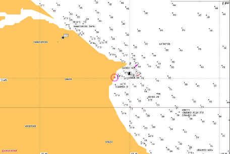
HISTORICAL CONTEXT

The Department of Planning was notified of the shipwreck remains located on
Crowdy Beach by Mr Paul Elger of Lansdowne (requirements of Historic
Shipwrecks Act, 1976; Section 17:1). Mr Elger's father had shown him the
wreck, the existence of which was known to some residents of the area.

A preliminary examination of available historical records indicated that several
coastal vessels have been lost in the Crowdy Bay area. While not always
providing specific details, the contemporary records indicated whether the
vessels were lost on Crowdy Beach, struck the reef areas, or foundered out in
the bay. The following list includes vessels known to have been lost in the
Crowdy Bay area:

Table 1: Steamer wrecks attributed to crowdy beach and north of the Manning River Bar

EMU                  steamer         9.10.1888    Sprung leak, driven ashore Crowdy Bay
                                                  (165t - Blt NZ).

FIRE KING            paddle steamer 30.4.1873     Swamped at Manning Bar, driven onto
                                                  north beach, wrecked (221 t - Blt NSW).

IRON CHIEF           steel steamer   1.4.1928     Total loss in shallows near Diamond
                                                  Head. (2686 tons, Blt 1916).

JUNO                 paddle steamer 24.10.1853    Leak at sea. Driven ashore about 1 mile
                                                  nth of Manning River (621 t - Blt
                                                  Greenock).

KOOROONGABA          paddle steamer -.1.1972      Foundered off Crowdy Head, an obsolete
                                                  Newcastle ferry (542t - Blt 1921).

SAMSON               paddle steamer 24.12.1908    Foundered after being abandoned off
                                                  Crowdy Head (101 t - Blt NSW).

SHELBOURNE           ketch (w)       14.2.1885    Foundered 5 miles off Crowdy Head (Blt
                                                  as a wooden steamship, 61t - Blt NSW)

ULMARRA              paddle steamer 10.10.1872    Driven ashore on North Beach, Manning
                                                  River (50t - Blt NSW)
Table 2: Sailing vessel wrecks attributed to crowdy beach and north of the Manning River Bar
ABBEY schooner (w) 14.2.1868 Wrecked 2 miles north of Crowdy Head
(90 t - Blt UK)
ATLANTA schooner (w) 28.7.1882 Wrecked north Head of Manning Bar (56
t - Blt NSW)
AMY ketch (w) 21.9.1879 Capsised at Manning River Bar, total
wreck on beach imm. nth (26 t - Blt
NSW?).
BARWON brigantine 15.2.1868 Disappeared near Crowdy Head in gale
(56 t - Blt NSW).
BROTHERS schooner (w) -.8.1848 Wrecked ashore at Crowdy Bay (10t - Blt
NSW)
CHEETAH schooner 16.2.1868 Wrecked 3 miles north of Crowdy Head
(119t - Blt UK)
EMILY ANN schooner (w) 27.11.1864 Capsised Manning Bar, wrecked Crowdy
Head (39t - Blt NSW).
GO-A-HEAD ketch (w) 9.3.1875) Wrecked on Nth spit, Manning Bar (29 t -
Blt NSW)
ISABEL schooner 6.5.1898 Wrecked Crowdy Bay (69t)
OCTOROON schooner 22.2.1878 Abandoned off Crowdy Head with leak
(52 t - Blt QLD).
RAVEN brigantine 15.2.1868 Wrecked 2 miles south of Crowdy Head
(1148t - Blt USA).
RESOLUTE ? 24.6.1879 Driven ashore, Crowdy Bay (65t - Blt
NSW).
SUSANNAH schooner 16.6.1868 Driven ashore Crowdy Bay (43t - Blt
NSW)
TRUSTY schooner (w) 8.5.1885 Total wreck imm. nth of Manning Bar (61
t - Blt ?).
Figure 1: Painting of SS Emu by William Forster. Courtesy Mr John Yeager and Ms Esme Smith.As these Tables show, several vessels were known to have been wrecked
between the Manning River Bar and Crowdy Bay. All sailing vessels were
immediately discounted (due to the presence of engines at the Crowdy Bay
site). From the list of known steamer losses, only the Emu was recorded as
lost ashore at the southern end of the Bay. The majority of vessels foundered
out in deeper water and many constituted paddle steamers, vessels with
engines not consistent with those visible on-site.
It was therefore considered likely that the remains constituted those of the Emu,
this view was strengthened with the results of the wreck inspection (below).
Historical details
The Emu, a wooden single screw steamship of 165 tons gross, was built in
Shortland (Auckland) New Zealand by Robert Stone in 1874 (1). The vessel had
a vertical compound steam engine generating 90 horsepower, built by Fraser &
Tinne of Auckland. With an overall length of 120.8 feet, breadth of 22.3 feet and
depth of 7.8 feet, the vessel was schooner rigged.
The original owner of the Emu was C.J. Stone and the vessel was registered in
Auckland (2). By 1879, ownership changed to T. Cowlinshaw and the steamer
became registered in Sydney. Transferred again to F.W. Cook in 1885, the Emu
was finally sold to W.T. Yeager in 1885, and again registered in Sydney.
William Tudor Yeager was an immigrant from the U.S.A (born Lubeck, Canada in
1839) and introduced the first steam drogher to the Richmond River (3).
Expanding into timber milling and other spheres in the region, he later entered
the Sydney-Richmond river passenger trade (c.1890). The Emu joined his early
fleet which comprised the schooner Neptune (221 t), the steamer Amphritrite
(120 t) and the tug Vesta (42 t) (4).
A fine wooden vessel with a "clipper bow" (Figure 1, 2), the Emu was employed
in the coastal trade under command of Norbert James Ivaney. At the time of loss
in 1888, the steamer was on a voyage from the Richmond River laden with
timber for Sydney (5). With nine hands onboard, the voyage went well until near
Seal Rocks when a sleety gale set in. The heavy south-east weather caused the
vessel to spring a leak, lose all sail and seek safety in Crowdy Bay. While riding
at anchor with 60 fathoms (110 meters) of cable out, it parted at 9.30 a.m.,
sending the Emu ashore to become a total wreck. When beached, the sides of
the vessel rapidly broke open, partly due to the heavy load of timber onboard
(6). The Emu was said to be lying "one mile north of Crowdy Head, on the
beach, and full of water". There was no loss of life (7). A Marine Board inquiry
into the disaster found no fault in the captain (8).
NOTES:
(1) British Register of Ships, 21 of 1879. ANMM Library.
Register of Australian And New Zealand Shipping (ANZ),
Merchant Shipping and Underwriters Association Ltd.Melbourne (Mitchell Library).
(2) Parsons, R., 1973, Australian Shipowners and Their
Fleets, vol 2. p.160.
(3) Parsons, R., 1973, Australian Shipowners and Their
Fleets, vol 2. p.163.
(4) S. Dening., nd, A History of Shipping on the Richmond
River (unpublished). Richmond River Historical Society.
p. 7.
(5) Sydney Morning Herald, 10 October, 1888.
Loney, Australian Shipwrecks. Vol 3, 1982. p.186.
(6) The Richmond River Herald, 9 October, 1888.
(7) Sydney Morning Herald, 10 October, 1888.
(8) The Richmond River Herald, 23 October, 1888.
Figure 2: Original photograph of the SS Emu taken in front of W.T. Yeager's home "Oakland
House". Courtesy Mr John Yeager and Ms Esme Smith.
Emu Wreck - Construction Details.
Official number: ON 70183
Built: 20 April, 1874
Where Built: Shortland, Auckland, New Zealand
Builders: Robert Stone
Owner: William T. Yeager (Coraki, Richmond River).
Construction: Wooden hull and framework, one deck, three masts,
schooner rigged.
Dimensions: Length: 120.8, Breadth: 22.3, Depth: 7.8 feet
Tonnage: 165 gross, 131 net
Figurehead: ShieldWrecked: 9 October, 1888. OBJECTIVES General To develop baseline data on the wreck site in relation to its environmental and archaeological characteristics; to develop site interpretation and an assessment of archaeological potential. Specific 1. To re-locate the wreck site and record an accurate position for the remains. 2. To carry out a general survey of the site to ascertain the extent and nature of the archaeological remains; to complete detailed site drawings (where possible) by which to graphically illustrate the above and, to assess the surviving extent of the buried structure. METHODOLOGY The shipwreck remains were known to local resident Paul Elger who notified the Department of Planning in March, 1994. Mr Elger provided photographs of the site and a location map by which to re-locate the area. The Department undertook a preliminary investigation of the site in July, 1994. There was no secure identification of the remains prior to the inspection. The presence of an engine and cylindrical boiler was known to local residents and beach users. There was not, however, widespread knowledge as to what the remains represented. Prior to the site inspection, the Department complied a list of known shipwreck losses in the area (above). Several vessels were known to have been wrecked between the Manning River Bar and Crowdy Bay. All sailing vessels were immediately discounted (due to the presence of engines on-site). Several steamers were known to have been wrecked in Crowdy Bay, however only the Emu was recorded as being lost on the southern end of the Bay, the majority foundering out in deeper water. The Emu's register details indicated that the vessel was fitted with a vertical compound engine. An analysis of the exposed portion of the engine in Crowdy Bay, confirmed that it was also representative of this type. Therefore, prior to the survey there was a strong likelihood that the remains belonged to the coastal steamer Emu. The current survey was conducted over two days (4-5 July, 1994). It was important to establish the extent of the buried portions of the wreck site and to confirm the materials used in the hull's construction. If the hull was found
to be timber, it would further point to the wreck being the Emu. A probe survey
was therefore employed. This had the benefit of minimal intrusion on the wreck
remains and being able to detect wood as opposed to metal refusals. The 3
meter probe could be manually handled with water intake via a hand held
compressor. A theodolite enabled all probes to be plotted and tied into the
Australian mapping grid.

Figure 3: Tim Smith operating water pump for probe survey
Figure 4: Extracting core sample of timber from inside aluminium pipe

Available information on the wreck site was forwarded to shipwreck specialist, Mr
John Riley, prior to the site visit. Mr Riley confirmed that the visible engine was
a vertical compound type consistent with that of the Emu.

Further, it was evident that the boiler had moved from its original position
forward of the high pressure cylinder to a position aft of the low pressure cylinder
(assuming a rear engined vessel - Figure 1,2). Mr Riley believed that the engine
was still attached to the hull (due to remaining in an upright position) and that
the buried portion of the hull probable runs on an axis through the line of the
engine. Apparent damage to the low pressure cylinder of the engine appeared
reminiscent of explosives, perhaps used during salvage work on the wreck. The
cylinder head cover is missing and the cylinder wall is damaged to the rear.

Mr Riley predicted that the buried hull remains would be located some 5 feet
below the upper level of the cylinder casing (Figure 6). This figure was based on
the calculation of the length of the engine's stroke.

It was also intended that a wood sample be removed from the buried hull to
assist with the identification of the site. If the timber could be established as a
New Zealand species, it would help to confirm that the vessel was indeed the
Emu. If however, the hull was constructed from Australian or foreign timbers, the
identification might need to be considered further.

Wreck Site Location
The engine and boiler remains were found to lie in the shallow surf zone of
Crowdy Beach at high tide, and exposed dry at extreme low tide (Figure 3, 7), (E
31o 50’ 02.78" S 152 o 44' 09.72" in WGS84 datum). A white painted wooden
peg marks the location of the wreck. It can be found located against the
vegetation line of the dunal area opposite the site, and approximately 1.3
kilometres north along the beach from the Crowdy Head Surf Life Saving Club.
Emu

                                                                   Crowdy Head

Figure 5: Location map (sources: Manly Hydraulics Laboratory)

Wreck Inspection
Two star pickets were placed to delimit the main search area (comprising
approximately 100 x 50 meters). This search area was obtained by mapping out
the known length and breadth of the Emu in relation to the orientation of the
engine and boiler. Working on the proviso that the vessel was of engine aft
design, this placed the majority of the wreck out from the beach, into the water.

The pickets served as a quick reference mark during the survey. Colin Browne
(MHL) undertook a preliminary probe survey (hand probe) to delimit buried
structure in the immediate vicinity of the engine remains. With the survey area
defined, the three meter probe survey was initiated. With one person operating
the probe, one controlling the pump and another the water intake and recording,
a large area of sand around the exposed remains was inspected. All probes
registering a refusal were plotted using an EDM theodolite. Most hit timber at
approximately 1.5 - 2 meters depth. Some 96 individual probes were completed,
covering an area of approximately 40 x 20 meters.

A timber sample was removed from the site with the aid of a powered drill. The
sample was taken forward of the engine after timbers were encountered using
the 3 meter probe. A metal caisson was lowered through the sand and onto the
buried timber. With the tube jetted free of sand, the drill was employed to
remove a c. 2.5 centimetre square sample of timber. This sample was forwarded
to CSIRO in Melbourne for species identification.
ENVIRONMENTAL DESCRIPTION Wreck Site Description Apart from the vertical compound steam engine and scotch boiler, barely exposed above the current sand levels, there is nothing to indicate the presence of a shipwreck. The probe survey however, confirmed that there is more to the shipwreck remains than those visible. A number of probes met a solid refusal at approximately 1.5 - 2 meter depth. These refusals were compatible with the probe striking timber remains. The majority of refusal were clustered around the engine. This was predicted earlier, as the upright nature of the engine suggested that it was still attached to a solid base. Timbers were encountered for a distance roughly equal on either side of the engine suggesting that the engine was attached centrally within the hull. Approximately 4 meters of the buried hull survives on the port side of the engine, and approximately 2-3 meters on the starboard side. The majority of the timber refusals were found to run in a line consistent with the orientation of the engine. The bulk of refusals were detected around the engine and aft of it (back towards the beach) that is, towards the stern of the vessel (Figure 7). These findings suggest that the bulk of the hull lying forward of the engine room (towards the bow and ocean - some 60-70 feet), has disappeared. This would not come as a surprise, the section of hull directed out towards the deeper water being more prone to direct wave and storm action. With continual buffeting subsequent to the wreck event, this portion of the vessel would have been more likely to quickly break up. The timber and other structure would have been easily carried away by natural forces. The weight of the engine and boiler would have aided the retention of the wooden hull lying under these features. It can be noted that wave action has carried the large boiler and re-located it aft of the engine remains. Upon completion of the survey, the timber sample was forwarded to the CSIRO's Division of Forest Products in Melbourne. The sample was analysed and found to be New Zealand Kauri Pine, a timber well used in shipbuilding. This finding adds strength to the argument that the inspected remains are those of the steamer Emu, a wooden vessel built in New Zealand in 1874.
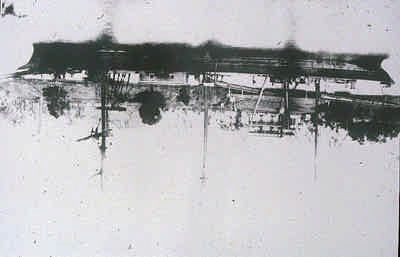
Figure 8: Photograph of exposed boiler
Figure 6: Location map showing the position of
wreck remains located on Crowdy Beach.
(Map: http://maritime.heritage.nsw.gov.au)

Figure 7: Photograph of exposed engine

Figure 9: Predictive plan showing the exposed remains and the likely extent of buried structure.
Proposed by Mr John Riley.
Figure 10: Results of probe survey, showing all probe refusals within the surveyed area.

ASSESSMENT OF SIGNIFICANCE
Significance has been assessed in accordance with the nature and degree of
significance of the site's primary attributes. These include attributes related to
historical, social, archaeological, scientific and interpretative significance.
Historical (Concerned with range of context)
Examination of the sites historical significance presumes that the site is that of
the Emu, 1888.
The Emu is representative of the coastal traders employed in New Zealand and
New South Wales in the latter part of the nineteenth century. Workhorses of the
coastal fleets, these vessels were often poorly recorded due to their common
occurrence.
Archaeological (Concerned with research potential through investigation of
material remains)
The archaeological potential of the wreck site has been reduced by the local
environmental conditions. The surviving remains are badly broken up within the
survey area.
The portion of wooden hull located is unlikely to be of significant archaeological
potential, however it retains the ability to contribute knowledge on New Zealand
wooden shipbuilding technology during the later nineteenth century.
STATEMENT OF SIGNIFICANCE
The limited nature of the remains do not currently provide enough information by
which to positively identify the vessel. The site inspection however, has
provided information to strongly link the wreck remains with the Emu lost in
1888.
Representative of the coastal steamer trade of New Zealand and New South
Wales, the Emu played a common but important role in the trans-shipment of
produce and goods between the developing coastal ports.
The provisions of the Commonwealth's Historic Shipwrecks Act, 1976 continue
to apply to the remains which are protected as an historic shipwreck.

RECOMMENDATIONS
As a result of the historical research, wreck site inspection and subsequent
assessment of significance, it is recommended that:
1. the Department of Planning undertake no further inspection of the site until
   such time as the remains largely buried on Crowdy Beach are again exposed.
   A detailed inspection of these remains may aid the current inspection of the
   shipwreck relics.
2. interested groups or individuals be encouraged, where possible, to undertake
   research into known vessel losses in the Crowdy Bay/Manning River area, in
   an attempt to further identify this site and other shipwreck remains.
You can also read