ORASECOM JOINT BASIN SURVEY(JBS) 3 - Draft Inception Report - GT1049/170621
←
→
Page content transcription
If your browser does not render page correctly, please read the page content below

ORASECOM JOINT BASIN
    SURVEY(JBS) 3

  Draft Inception Report

     GT1049/170621
       June 2021
ORASECOM JBS3
Draft Inception Report
                                                                          2021

Title                               ORASECOM JOINT BASIN SURVEY (JBS) 3

Report Issue                        Inception Report: Draft 1

Consultant Ref Number               GT1049/170621

Prepared by

                                    Kylie Farrell (Pr. Sci. Nat.)

                                    Dr Mark Graham (Pr. Sci. Nat.)

                                    Gary de Winnaar (Pr. Sci. Nat.)
Author(s)
                                    Adrienne Louw

Document Reviewer

Prepared For

© GroundTruth Water, Wetlands and Environmental Engineering                  ii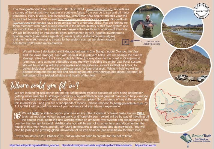
ORASECOM JBS3
Draft Inception Report
                                                                                                 2021

COPYRIGHT

All intellectual property rights and copyright associated with GroundTruth’s services are reserved and
project deliverables may not be modified or incorporated into subsequent reports, in any form or by
any means, without the written consent of the author/s. Similarly, reference should be made to this
report should the results, recommendations or conclusions stated in this report be used in subsequent
documentation. Should this report form a component of an overarching study, it is GroundTruth’s
preference that this report be included in its entirety as a separate section or annexure/appendix to
the main report.

INDEMNITY

The project deliverables, including the reported results, comments, recommendations, and
conclusions, are based on the author’s professional knowledge, as well as available information. The
study is based on assessment techniques and investigations that are limited by time and budgetary
constraints applicable to the type and level of survey undertaken. GroundTruth therefore reserves the
right to modify aspects of the project deliverables if and when new/additional information may
become available from research or further work in the applicable field of practice or pertaining to this
study.

GroundTruth exercises reasonable skill, care, and diligence in the provision of services; however,
GroundTruth accepts no liability or consequential liability for the use of the supplied project
deliverables (in part, or in whole) and any information or material contained therein. The client,
including their agents, by receiving these deliverables, indemnifies GroundTruth (including its
members, employees, and sub-consultants) against any actions, claims, demands, losses, liabilities,
costs, damages and expenses arising directly or indirectly from, or in connection with services
rendered, directly or indirectly, by GroundTruth.

© GroundTruth Water, Wetlands and Environmental Engineering                                           iii
ORASECOM JBS3
Draft Inception Report
                                                                                                                                                  2021

TABLE OF CONTENTS

COPYRIGHT ................................................................................................................................ iii
INDEMNITY ................................................................................................................................ iii
TABLE OF CONTENTS .................................................................................................................. iv
LIST OF FIGURES......................................................................................................................... vi
LIST OF TABLES .......................................................................................................................... vi
LIST OF ACRONYMS................................................................................................................... vii
1.           INTRODUCTION ............................................................................................................1
2.           Study Objectives ...........................................................................................................3
3.           Background ..................................................................................................................3
3.1          Summary of the Previous JBS3 Results.................................................................................. 4
4.           Methods .......................................................................................................................6
4.1          Sampling Teams ..................................................................................................................... 6
4.2          Study Area and Site Selection................................................................................................ 7
4.3          Pre-sampling Expert Refresher Workshop Training and Survey Programme ....................... 9
4.4          Aquatic Ecosystem Health (AEH) Sampling Protocols ........................................................... 9
4.4.1        Aquatic macroinvertebrates .................................................................................................. 9
4.4.2        In situ water quality, microbial and water chemistry.......................................................... 13
4.4.3        Fish....................................................................................................................................... 13
4.4.4        Riparian vegetation ............................................................................................................. 14
4.4.5        Instream and riparian habitat integrity ............................................................................... 14
4.5          Persistent Organic Pollutants (POPs), Metals and Other Compounds ................................ 14
4.5.1        Sediment.............................................................................................................................. 14
4.5.2        Bird eggs .............................................................................................................................. 15
4.5.3        Fish tissue ............................................................................................................................ 15
4.6          Innovative Monitoring Supplements ................................................................................... 15
4.6.1        Benthic diatoms ................................................................................................................... 15
4.6.2        eDNA .................................................................................................................................... 16
4.6.3        Microplastics........................................................................................................................ 16
4.7          Radiological Analyses .......................................................................................................... 17
4.8          Inter-laboratory Benchmarking Protocol/Programme ........................................................ 17
4.9          Data Collation ...................................................................................................................... 19
4.10         Data Interpretation and Reporting ...................................................................................... 19
5.           Groundwater Programme ........................................................................................... 20

© GroundTruth Water, Wetlands and Environmental Engineering                                                                                               iv
ORASECOM JBS3
Draft Inception Report
2021
6. JBS3 Survey Programme.............................................................................................. 21
7. Stakeholder Engagement Programme (Capacity Building and Citizen Science) .............. 22
7.1 Capacity Building ................................................................................................................. 23
7.1.1 In-field surveys and post-field data processing and model developments ......................... 23
7.1.2 Post-field data processing and model developments ......................................................... 23
7.2 Citizen Science ..................................................................................................................... 24
7.2.1 Becoming a Mehloli ea Rona River Scientist for a Day ........................................................ 24
7.2.2 Virtual tours ......................................................................................................................... 25
7.2.3 Learning support resources for Mehloli ea Rona ................................................................ 25
7.2.4 Sub-regional leadership seminars ....................................................................................... 25
7.2.5 The leadership seminar structure ....................................................................................... 26
7.2.6 Supplementary webinar courses ......................................................................................... 26
7.2.7 Biomonitoring and miniSASS ............................................................................................... 27
7.2.8 Learning support materials ................................................................................................. 27
7.2.9 The Joint Basin Challenge .................................................................................................... 27
8. Previous JBS2 Learnings and Solutions for JBS3 ............................................................ 28
8.1 General Timeframes for Administrative Documents .......................................................... 28
8.2 Inter-laboratory Benchmarking (ILB) Program .................................................................... 28
8.3 Persistent Organic Pollutants .............................................................................................. 28
8.4 Water Quality Data .............................................................................................................. 29
8.5 How can ORASECOM help? ................................................................................................. 29
9. JBS3 Limitations and Risks........................................................................................... 30
9.1 Covid-19 ............................................................................................................................... 30
9.2 Aquatic Ecosystem Health monitoring ................................................................................ 30
9.3 Sample delivery ................................................................................................................... 31
9.4 General health and safety ................................................................................................... 31
10. Project Deliverables and Timeframe Schedule ............................................................. 32
11. Key Summary Points ................................................................................................... 37
12. References ................................................................................................................. 38
13. Appendices................................................................................................................. 40
© GroundTruth Water, Wetlands and Environmental Engineering vORASECOM JBS3
Draft Inception Report
2021
LIST OF FIGURES
Figure 3-1 Map representing the AEH sites sampled in JBS2 in the Orange-Senqu River Basin ......... 4
Figure 4-1 Overview of sample site locations within the Vaal, Upper Orange, Lower Orange
and Ephemeral subcatchments .......................................................................................... 8
LIST OF TABLES
Table 4-1 Personnel comprising field teams and key experts/team leaders ..................................... 6
Table 4-2 Additional expert team members ...................................................................................... 6
Table 4-3 Sites selected for the ORASECOM Joint Basine Surevy (JBS) 3 covering the Vaal,
Upper Orange, Lower Orange and Ephemeral subcatchments where various
assessments will be performed at each site including aquatic ecosystem health
(AEH), water quality (WQ), inter-laboratory benchmarking(ILB), persistent organic
pollutants (POPs), metals, microplastics, radiological, eDNA and groundwater ............. 10
Table 4-4 Ecological categories, category names adn assocaited meaning with colour codes used
to interpret Ecological Category ....................................................................................... 19
Table 10-1 Project deliverables associated with the ORASECOM JBS3 (2021) .................................. 33
© GroundTruth Water, Wetlands and Environmental Engineering viORASECOM JBS3
Draft Inception Report
2021
LIST OF ACRONYMS
AEH Aquatic Ecosystem Health
AQC Analytical Quality Control
Cefas Centre foe Environment, Fisheries and Aquaculture Science
CLiP Commonwealth Litter Programme
CS Citizen Science
DEFF Department of Environment, Forestry and Fisheries
DO Dissolved Oxygen
DWA Department of Water Affairs
DWS Department of Water and Sanitation
eDNA Environmental DNA
FPA Fine Particle Application
FRAI Fish Response Assessment Index
GIS Geographic Information System
GSM Gravel, Sand and mud
GW Groundwater
IFR In-stream Flow Requirement
IHI Index of Habitat Integrity
ILB Inter Laboratory Benchmarking
ISO International Organization for Standardization
JBS Joint Basin Survey
LHDA Lesotho Highlands Development Agency
MIRAI Macroinvertebrate Response Assessment Index
NaDEET Namib Desert Environmental Education Trust
NASS2 Namibian Scoring System Version 2
NFEPA National Freshwater Ecosystem Priority Areas
ORASECOM Orange-Senqu River Commission
POPs Persistent Organic Pollutants
PPE Personal Protective Equipment
SABS South African Bureau of Standards
RHP River Health Programme
SADC Southern African Development Community
SASS5 The South African Scoring System Version 5
SE Stakeholder Engagement
SPI Specific Pollution sensitivity Index
TDS Total Dissolved Solids
© GroundTruth Water, Wetlands and Environmental Engineering viiORASECOM JBS3
Draft Inception Report
2021
ToR Terms of Reference
UCT University of Cape Town
VEGRAI Vegetation Response Assessment Index
WMA Water Management Area
WWTW Wastewater Treatment Works
© GroundTruth Water, Wetlands and Environmental Engineering viiiORASECOM JBS3
Draft Inception Report
2021
1. INTRODUCTION
The Orange-Senqu River is a multilateral and multinational river system which holds much importance
both ecologically and economically. The river system is sourced from the mountainous terrain of the
Kingdom of Lesotho, and flows through the semi-arid and arid landscapes of South Africa, Botswana
and southern Namibia, covering an area approximately 1 000 000km2. The Johannesburg economic
hub, the largest Economic hub in the SADC region, depends on this basin for virtually all of its water.
Therefore, it is a valuable river system, although under great pressure, heavily utilised and depended
upon by various activities namely industrial (mining and manufacturing), agriculture, energy,
residential uses, tourism and conservation. Consequently, the impacts emanating from these various
activities include an increase in water demands, decline in water resource quality, changes to the
hydrological regime, land degradation and ultimately changes to the aquatic ecosystem and its biota.
Therefore, if one does not monitor, one cannot manage. Consequently, the Orange-Senqu River
Commission (ORASECOM) was established by the governments of Botswana, Lesotho, Namibia and
South Africa to advise them on water-related issues to ensure equitable and sustainable development
and management of the water resources within the river basin.
Every five (5) years, ORASECOM conducts an aquatic ecosystem health (AEH) Joint Basin Survey (JBS)
of this valuable freshwater aquatic ecosystem from source to sea. The initial purpose of this study was
twofold in that:
1) it was intended to undertake the first baseline monitoring of aquatic ecosystem health (AEH) in
the Orange-Senqu River System against which ORASECOM could monitor impacts/trends of any
basin wide measures taken through future 5 yearly intensive monitoring programmes; and
2) it was used to define appropriate sampling sites, based on sites visits and local knowledge, that
could be used in future surveys.
The JBS SES will be structured and aligned to the Sustainable Development Goals (SDGs). The SDGs
describe a course of action to address poverty, protect the planet and ensure prosperity for all — The
2030 Agenda for Sustainable Development. Sustainable Development Goal 6 is about "clean water
and sanitation for all", and obviously forms a core focus to JBS3, but actively aligned with Target 6.3 –
Water quality and wastewater, aims to achieve the following:
“By 2030, improve water quality by reducing pollution, eliminating dumping and minimizing
release of hazardous chemicals and materials, halving the proportion of untreated
wastewater and substantially increasing recycling and safe reuse globally”
How is this measured within the framework of SDG reporting? Well, indicator 6.3.2 “Proportion of
bodies of water with good ambient water quality” is perfectly aligned with the ethos of what JBS3 is
aiming to do, specifically the indicator tracks the percentage of water bodies (rivers, lakes and
groundwater) in a country with good ambient water quality. “Good” indicates an ambient water
quality that does not damage ecosystem function or human health according to core ambient water
quality parameter groups that are relevant globally. JBS3 obviously takes this further and with more
© GroundTruth Water, Wetlands and Environmental Engineering 1ORASECOM JBS3
Draft Inception Report
2021
detailed analysis and reporting, but is a clear and useful articulation with the SDG goals and which
ORASECOM can report on.
The first survey (JBS1) was conducted in 2010, followed by JBS2 in 2015. GroundTruth Water,
Wetlands and Environmental Engineering (GroundTruth) were appointed to undertake JBS2. Through
this, GroundTruth gained significant experience and understanding of the logistics of the project and
the basin itself. Consequently, GroundTruth have been appointed to conduct the third round of the
five-yearly intensive monitoring programme established for the Basin – JBS3. GroundTruth intends to
build on the strong foundations and recommendations laid out in JBS2, offering significant ecological
and technical insights and appreciations of the challenges previously faced during JBS2 to include
adaptations in JBS3. Furthermore, GroundTruth’s international and local experience with Citizen
Science (CS) tools will enhance and ensure meaningful and innovative informal and formal stakeholder
engagement (SE) across the basin. Overall, GroundTruth aims to enhance JBS3 through further
refinement of protocols and analyses, inclusion of additional parameters, and expansion of the
breadth of interlaboratory benchmarking (ILB).
Using historical data retrieved, experience obtained through previous work in the basin and improved
technology, GroundTruth’s primary aims relating to JBS3 are:
1) to improve on and successfully implement the workplan followed in JBS2; and
2) to include groundwater (GW) and Persistent Organic Pollutants (POPs) specialists to analyse
these parameters, including microplastics.
In addition to the JBS2 workplan, which included the sampling of several key river health and water
resource components, namely AEH and chemical and microbial water quality (including an ILB
programme), as well as GW sampling, the sampling of microplastics, POPs, metals and other
compounds contained within sediment, bird eggs and fish tissue will be conducted, and radiological
analyses undertaken. GroundTruth will also be supplementing JBS3 with additional and innovative
monitoring tools not explicitly requested in the ToR. These additional monitoring tools will include:
• Diatoms
• Environmental DNA (eDNA)
• Additional microplastic sampling
• E.coli swabs
• Radiological analyses
The inclusion of these innovative monitoring tools will allow for additional biological data and
information about important water resources within the basin to be obtained, increase the level of
confidence in collected data, improve analytical capacity and ultimately enhance understanding of the
basin and its water resources. Furthermore, these supplementary innovative monitoring tools will
help achieve the Commission’s mandate of providing technical advice to the Member States (Parties)
on matters relating to the development, utilisation, and conservation of the water resources in the
Orange-Senqu River Basin.
© GroundTruth Water, Wetlands and Environmental Engineering 2ORASECOM JBS3
Draft Inception Report
2021
The specific purpose of this inception report is to outline a detailed work programme for the proposed
sampling to be undertaken as part of JBS3 in 2021/2022. Aspects addressed in this report include:
• The proposed sampling sites for the survey of the AEH;
• The daily work and travel plan for each of the sampling teams;
• The route plan for each sampling team;
• The sampling methodology to be applied at all AEH sites, including the innovative
supplementary sampling;
• The proposed transboundary surface water quality sites and sampling methodology for the ILB;
• Site selection for the groundwater sites;
• Stakeholder engagement (SE), including innovative ways to approach capacity building and
citizen science (CS);
• Summary of previous JBS2 results;
• Previous JBS2 learnings/challenges and identified solutions (ILB approach, costs, logistics and
inter alia sample permits and crossing borders);
• Limitations and risks, including the current COVID-19 pandemic restrictions to achieving some
of the objectives of the JBS3; and
• Project deliverables and work schedule.
2. STUDY OBJECTIVES
The primary objectives of the AEH JBS will be as follows:
• Continue monitoring the baseline AEH which will enable ORASECOM to keep track of the aquatic
health and integrity of the river basin;
• Continue to address and monitor priority environmental concerns, existing and emerging
threats to the water quality throughout the basin, using various monitoring tools.
• Enhance the knowledge, understanding and awareness of the importance of this system
through the following means:
o Capacity building, training initiatives for stakeholders, teachers, students, communities, key
institutions and expert in the basin.
o Assisting and supporting basin wide participating laboratories to improve their water quality
analytical performance testing and confidence, as well as continuation of the interlaboratory
comparison studies previously undertaken in JBS2.
3. BACKGROUND
The field sampling component of the Orange-Senqu River Water Resources Quality Third Joint Bain
Survey (JBS3) is anticipated to be undertaken at some stage between 3rd October 2021 and 23rd
October 2021. The survey will provide the third comprehensive assessment of the chemical, physical,
and ecological condition of the Orange-Senqu River Basin. The JBS3 will draw on the lessons learned
© GroundTruth Water, Wetlands and Environmental Engineering 3ORASECOM JBS3
Draft Inception Report
2021
from JBS2, as well as from the expertise of personnel participating from member states. A summary
of the results obtained from JBS2 are presented below.
3.1 Summary of the Previous JBS3 Results
During JBS2 a total of 39 sites were sampled for AEH and six were sampled for groundwater. Tools
utilised to provide a comprehensive measure of AEH at the sampling sites covered assessments of
macroinvertebrates (SASS5 and MIRAI), water quality, fish (FRAI), diatoms (SPI), riparian vegetation
(VEGRAI) and habitat integrity (IHI). A summary of the integrated AEH results obtained during the
JBS2 survey is provided in the map below.
OSAEH 11_8
OSAEH 11_14
OSAEH 11_3
OSAEH 11_13
OSAEH 11_4
OSAEH 11_1
OSAEH 29_1
OSAEH 11_6
OSAEH 29_2
OSAEH 29_4
OSAEH 11_21
OSAEH 26_1
OSAEH 29_5
OSAEH 28_4 OSAEH 28_1 OSAEH 26_17 OSAEH 26_16
OSAEH 26_3 OSAEH 11_18
OSAEH 28_5 OSAEH 28_3 OSAEH 28_2
OSAEH 26_2
OSAEH 26_10
OSAEH 26_7 OSAEH 26_15
OSAEH 26_4 OSAEH 15_1
OSAEH 11_20
OSAEH 26_8
OSAEH 15_6
OSAEH 26_12
OSAEH 26_14
OSAEH 11_22
OSAEH 15_2
OSAEH 15_5
OSAEH 26_13
OSAEH 26_11
OSAEH 15_3
Figure 3-1 Map representing the AEH sites sampled in JBS2 in the Orange-Senqu River Basin
© GroundTruth Water, Wetlands and Environmental Engineering 4ORASECOM JBS3
Draft Inception Report
2021
Results obtained during JBS2 indicated that much of the Vaal Catchment was in an impacted to highly
impacted condition, C-C/D category, with the Upper Vaal WMA being particularly impacted. The major
impacts driving the conditions at the sites included the presence of a large number of dams, extensive
mining operations and agriculture.
Similar to Vaal Catchment, much of the Upper Orange/Senqu Catchment was also in an impacted to
highly state, C-D category. Surprisingly, sites located within the upper reaches of the Senqu and
Caledon Rivers were in a largely modified condition, likely due to extensive land use change and
agricultural practices. Other impacts driving the condition of sites within the Catchment included
irrigation, hydropower releases from major upstream dams, and WWTW effluent releases.
Results obtained for the Lower Orange revealed that as downstream distance increased, overall
EcoStatus condition improved. Sites in the upper reaches of the system were generally moderately
modified (C category), whilst those in the lower reaches were in a largely natural to moderately
modified condition (B-B/C-C categories). The modified conditions observed in the upper reaches of
the system were likely attributable to the effects of intensive agriculture and upstream dam releases.
Conversely, the largely natural conditions observed in the lower reaches were likely a reflection of less
intensive agriculture in the region, lower population densities and more intact ecological
infrastructure as a result of protected areas and low-density livestock farming.
A comparison between results obtained from JBS1 and those obtained from JBS2 indicated a general
decline in the overall EcoStatus for the sites that were measured in both JBS1 and JBS2. However,
given that only two surveys were available from which to draw data, confidence in the observed trends
is low. Additional data collected during JBS3 will assist in more clearly identifying any trends in AEH.
© GroundTruth Water, Wetlands and Environmental Engineering 5ORASECOM JBS3
Draft Inception Report
2021
4. METHODS
4.1 Sampling Teams
In order to assess the ecosystem characteristics and variation of major lotic ecosystems within the
Orange-Senqu basin on a relatively large spatial scale, monitoring will be performed by three teams
each comprising experts/non-key experts that are competent and capable of sampling the different
AEH components as highlighted in Table 3.1. The plan is to have three field teams with a balance of
expertise to cover the key aspects needing sampling for JBS3 within the various geographic areas. The
three teams will be split to cover the ground efficiently as follows:
• The upper Orange/Senqu;
• The Vaal catchment; and
• The lower Orange.
Field survey teams have been structured in such a way so as to comprise all key and non-key experts,
GW, SE, POPs and microplastics experts with significant international and local profiles, an extensively
published record, and expertise in their respective disciplines, as well as a basin wide network of
contacts to ensure this aspect maximizes the opportunity to profile the JBS3 survey as well as
ORASECOM. The key experts on each team will serve as the team leaders.
Table 4-1 Personnel comprising field teams and key experts/team leaders
Component Team 1-Upper Orange Team 2- Vaal Team 3- Lower Orange
Fish Byron Grant Andrew Husted Dr Mahommed Desai
Macroinvertebrates Juan Tedder Kylie Farrell* Dr Nick Rivers-Moore
Vegetation Dr Mark Graham* Martinus Erasmus Gary de Winnaar*
IHI, Water Quality, Diatoms Ayanda Lepheana Michael Ryan Adrienne Louw
* Team leads
Table 4.2 includes the rest of the expert support team members who will not be involved in the field
sampling directly but will help coordinate the collection and delivery of samples for ILB, interpretation
of various water quality components, as well as the associated reporting thereof, for the purpose and
success of this project.
Table 4-2 Additional expert team members
Component Expert member
Diatoms Dr Jonathan Taylor
Groundwater Dr Digby Gold
POPs Dr Esta van Heerden
Bird Eggs Dr Hanlie Smit-Robinson
Microplastics Prof Peter Ryan
eDNA Dr Vere Ross-Gillespie
© GroundTruth Water, Wetlands and Environmental Engineering 6ORASECOM JBS3
Draft Inception Report
2021
The SE team includes senior members from Lesotho, SA, Botswana and Namibia, and will be led by Dr
Jim Taylor, who has recently published a review of the Post-Covid realities in Africa and India. He will
collaborate with the following expert team members from each SADAC region within the basin:
• South Africa (GroundTruth)
o Ayanda Lepheana; and
o Adrienne Louw
• Lesotho (Department of Science Education (National University of Lesotho):
o Assoc. Professor Dr Tsepo Mokuku;
o Bonang Mosiuoa;
o Thabo Nobala; and
o Dr Lerato Seleteng-Kose (Senior Lecturer, Department of Biology at the National
University of Lesotho -Roma).
• Botswana
o Prof MJ Kethoilwe (Head of Department, Languages and Social Sciences at the
University of Botswana).
• Namibia
o Shirley Behune (Senior Lecturer (Namibia University of Science & Technology);
o Richard Kavari;
o Wayne Handley (Chief Warden, K Tsau //Khaeb (Sperrgebiet) National Park); and
o Viktoria Keding (NaDEET CEO).
4.2 Study Area and Site Selection
The study area covers the entire Orange-Senqu River Basin which is divided into four subcatchments,
namely the Vaal, Upper Orange, Lower Orange, and the Ephemeral Systems (Figure 4-1). Sample sites
were initially selected to meets the requirements of the JBS3 ToR. These were refined and optimised
based on knowledge of the previous JBS1 and JBS 2 studies to ensure that sites covering the various
components (e.g. AEH, POPs, etc.) were aligned as much as possible. In particular, sites selected for
JBS3 maintain congruency with the AEH and POPs studies from JBS2 while ensuring the introduction
of new assessment techniques such as microplastics. In summary, the number of sites include 40
detailed AEH (where all indicators will be sampled, i.e. water quality, benthic diatoms,
macroinvertebrates, fish, riparian vegetation, etc.), eight basic AEH (where only water quality and
benthic diatoms will be sampled), up to 19 POPs (including three bird egg and fish tissue samples), 15
microplastic, eight radiological, six groundwater, and ten eDNA sites. The location of all the sites are
presented in Figure 4-1 according to the core indicators (i.e. AEH, POPs and groundwater).
© GroundTruth Water, Wetlands and Environmental Engineering 7ORASECOM JBS3
Draft Inception Report
2021
Figure 4-1 Overview of sample site locations within the Vaal, Upper Orange, Lower Orange and Ephemeral subcatchments
© GroundTruth Water, Wetlands and Environmental Engineering 8ORASECOM JBS3
Draft Inception Report
2021
4.3 Pre-sampling Expert Refresher Workshop Training and Survey
Programme
The three teams will meet at Rooiport (near Douglas) during the first week of October 2021 where
Professor Victor Wepener (North-West University) will provide them with a one-day expert refresher
workshop training session on the review, familiarisation, and standardisation of all POPs protocols. On
the day following this training session each team will independently conduct sampling at two sites in
the Vaal system near Douglas, after which they will return to Rooiport to discuss problems
encountered (i.e. with equipment, sampling protocol, logistics). The objective of this process is to
standardise sampling protocols and procedures, eliminate technical issues and share information and
lessons learned.
Following the pre-sampling workshop, the three sampling teams will depart from Rooiport to
commence with sampling of the three main river reaches. Team 1 will focus on sampling sites situated
along the upper Orange River, extending east from Rooiport to the Malibamatsu, Lesotho. Team 2
will concentrate on sampling sites situated along the Vaal River and its major tributaries extending
north-east from Rooiport to the Klip River. Team 3 will focus on sites situated along the lower reaches
of the Orange River and its major tributaries, extending west from Rooiport to the Fish River, Namibia.
The teams will work concurrently in the specified areas. It is anticipated that teams will, on average,
sample two sites per day. Sites that require intensive fish sampling (owing to their importance),
however, will require a whole day to be effectively sampled, with nets deployed over-night. Between
10-15 days are thus expected to be required by each sampling team to complete sampling at their
allocated sites.
4.4 Aquatic Ecosystem Health (AEH) Sampling Protocols
The sampling protocols utilised in the survey represent the most up-to-date set of tools that have
been approved, adopted and widely utilised by the South African Department of Water and Sanitation
(DWS), water authorities and consultants across South Africa. The combination and application of
these tools will provide a comprehensive measure of AEH at the selected sampling sites (Figure 4-1)
within the Orange-Senqu River Basin, by performing river health assessments using water quality,
macroinvertebrate, fish, riparian vegetation and habitat integrity indicator tools. Each of these river
health tools will be assessed at 48 sites out of the total 60 sites selected for JBS3 (Figure 4-1 and Table
4-3). These have been closely aligned to the previous JBS1 and JBS2 surveys for trend analysis
purposes, as well as assessment of system drivers.
4.4.1 Aquatic macroinvertebrates
Macroinvertebrate families vary in their pollution tolerances. This makes them ideal indicators of
water quality in freshwater ecosystems. In addition, macroinvertebrates react quickly to pollution
events and are able to colonise previously disturbed/polluted habitats if conditions improve.
Additionally, they integrate water quality conditions over time and account for synergistic and additive
effects of different water quality parameters.
© GroundTruth Water, Wetlands and Environmental Engineering 9ORASECOM JBS3
Draft Inception Report
2021
Table 4-3 Sites selected for the ORASECOM Joint Basine Surevy (JBS) 3 covering the Vaal, Upper Orange, Lower Orange and Ephemeral
subcatchments where various assessments will be performed at each site including aquatic ecosystem health (AEH), water quality (WQ),
inter-laboratory benchmarking(ILB), persistent organic pollutants (POPs), metals, microplastics, radiological, eDNA and groundwater
Detailed* POPs
Site Basic# Micro- Radio- Ground-
Site Code River Latitude Longitude AEH & ILB & eDNA
ID AEH & WQ plastics logical water
WQ Metals
Vaal Catchment
1 OSAEH_11_9 Klip -27.470080 29.600480 Y Y Y
2 OSAEH_11_16 Wilge -27.307000 28.541950 Y
3 OSAEH_11_2 Vaal -27.038200 28.573930 Y Y Y
Vaal River (d/s of
4 Vaal -26.881848 28.111803 Y
Vaal Dam)
5 OSAEH_11_8 Blesbokspruit -26.477589 28.426916 Y Y Y
6 OSAEH_11_14 Suikerbosrand -26.681190 28.049640 Y
7 OSAEH_11_12 Klip -26.549340 28.064350 Y
Vaal River
8 Vaal -26.682234 27.937841 Y Y
(Vereeniging)
9 Vaal River (Parys) Vaal -26.913237 27.391412 Y
10 OSAEH_11_3 Mooi -26.684370 27.099800 Y Y
11 OSAEH_11_6 Renoster -27.040990 26.996380 Y
12 Vaal River (Orkney) Vaal -27.010000 26.680000 Y
13 OSAEH_11_4 Skoonspruit -26.934510 26.664280 Y Y Y
14 OSAEH_11_5 Vals -27.486830 26.813050 Y
15 OSAEH_11_1 Vaal -27.516060 26.209990 Y ? Y Y Y
16 OSAEH_29_3 Vet -27.934120 26.120940 Y
17 Bloemhof Dam Vaal -27.669782 25.645761 Y Y Y
18 OSAEH_29_2 Vaal -28.111800 24.811380 Y Y
19 OSAEH_29_1 Harts -28.379280 24.301780 Y
20 OSAEH_29_4 Vaal -28.703100 24.074280 Y Y
21 OSAEH_11_21 Karonnaspruit -29.085840 26.633841 Y
© GroundTruth Water, Wetlands and Environmental Engineering 10ORASECOM JBS3
Draft Inception Report
2021
Detailed* POPs
Site Basic# Micro- Radio- Ground-
Site Code River Latitude Longitude AEH & ILB & eDNA
ID AEH & WQ plastics logical water
WQ Metals
22 OSAEH_11_18 Modder -29.160670 26.572250 Y
23 OSAEH_11_19 Modder -28.807220 26.106940 Y
24 OSAEH_26_10 Riet -29.575270 25.708050 Y
25 OSAEH_29_5 Riet -29.026963 24.512919 Y
26 OSAEH_26_1 Vaal -29.055032 23.821032 Y Y Y Y Y Y
Upper Orange Catchment
27 OSAEH_15_1 Caledon -28.723127 28.155754 Y Y Y
28 OSAEH_15_6 Caledon -29.371059 27.405291 Y Y Y Y Y
29 OSAEH_11_20 Leeuspruit -29.517692 27.129677 Y
30 OSAEH_15_2 Matsuko -29.234098 28.561823 Y
31 OSAEH_15_3 Renoster -30.065580 28.408956 Y Y
32 OSAEH_15_5 Senqunyane -30.021057 28.182954 Y
33 OSAEH_11_22 Orange -30.504720 27.213977 Y Y
34 OSAEH_26_11 Kraai -30.690069 26.741568 Y
35 OSAEH_26_13 Stormbergspruit -30.650172 26.465164 Y
36 OSAEH_26_14 Orange -30.571418 26.451660 Y Y
37 OSAEH_26_8 Caledon -30.427571 26.305008 Y Y
38 OSAEH_26_15 Orange -30.503784 25.240033 Y Y
39 OSAEH_26_12 Seekoei -30.373578 25.000950 Y
40 OSAEH_26_2 Orange -29.643565 24.215537 Y Y
41 OSAEH_26_3 Orange -29.142069 23.691907 Y Y Y Y Y ?
Lower Orange Catchment
42 OSAEH_26_7 Brak -29.622990 23.016668 Y
43 OSAEH_26_16 Orange -29.655185 22.744638 Y
44 OSAEH_26_17 Orange -28.437353 21.401059 Y Y Y Y
45 OSAEH_26_4 Hartbees -28.857377 20.642833 Y
46 OSAEH_28_2 Orange -28.510598 20.171900 Y Y Y
© GroundTruth Water, Wetlands and Environmental Engineering 11ORASECOM JBS3
Draft Inception Report
2021
Detailed* POPs
Site Basic# Micro- Radio- Ground-
Site Code River Latitude Longitude AEH & ILB & eDNA
ID AEH & WQ plastics logical water
WQ Metals
Molopo River
47 Molopo -28.464097 20.285076 Y
(Riemvasmaak)
48 OSAEH_28_1 Orange -28.958260 19.172805 Y Y
49 OSAEH_28_3 Orange -28.897728 18.391482 Y Y
50 OSAEH_28_4 Orange -28.762038 17.725099 Y
51 OSAEH_26_18 Fish -26.803130 17.789420 Y Y
52 OSAEH_28_5 Orange -28.077724 16.944311 Y Y Y Y Y
53 OSSWQ_28_4 Orange -28.565938 16.504421
54 Molopo Eye Molopo Eye -25.886822 25.025184 Y Y
Ephemeral Systems
51 OSAEH_26_18 Fish -26.803130 17.789420 Y Y
54 Molopo Eye Molopo Eye -25.886822 25.025184 Y Y
GW1 OSGW_1 Wells near Steynsrus -23.647475 18.388726 Y
GW2 OSGW_2 Wells near Tweerivier -24.550110 18.562200 Y
GW3 OSGW_3 Wells near Tsahbong -26.072368 22.374588 Y
Wells near Bokspits
GW4 OSGW_4 Y
Khawa -26.469361 20.617194
Wells near Pioneer
GW5 OSGW_5 Y
(Kuruman) -27.285922 22.488683
GW6 OSGW_6 Wells near Kanye -25.763613 25.226076 Y
* Detailed AEH includes: benthic diatoms, aquatic macroinvertebrates, fish, riparian vegetation, and instream/riparian habitat integrity
# Basic AEH includes only benthic diatoms
© GroundTruth Water, Wetlands and Environmental Engineering 12ORASECOM JBS3
Draft Inception Report
2021
The South African Scoring System version 5 (Dickens and Graham, 2002) was developed as a rapid
technique for determining aquatic ecosystem health using aquatic macroinvertebrates as
bioindicators. The SASS5 technique has been accredited to ISO 17025 standards and forms part of
one of the DWS river eco classification models for EcoStatus determination. In a similar manner NASS2
(Palmer and Taylor, 2004) was developed to account for additional tropical invertebrate taxa that
occur in Northern Namibia.
The disadvantage of the aforementioned methods is that certain instream habitat types must ideally
be present for the method to accurately measure river health. Habitat types include stones (in current
and out of current), GSM (gravel, sand and mud) and vegetation (aquatic and marginal). Reliability of
the results is reduced if one or more of these three key biotopes are absent.
Standard SASS5 and NASS2 sampling procedures will be performed by accredited SASS5 practitioners
at all selected sampling sites. Sampling will be undertaken at the sites dependent on whether
appropriate conditions prevail for sampling (e.g. availability of biotopes, flowing not stagnant water,
not flood conditions, wadeable water depth, etc.). The SASS5 and NASS2 data collected, will then be
used to perform desktop analyses using the DWA EcoStatus tool – MIRAI (Macro-invertebrate
Response Assessment Index) (Thirion, 2008).
4.4.2 In situ water quality, microbial and water chemistry
In line with standard bioassessment protocols and following the recommendations made in the
Orange-Senqu Aquatic Ecosystem Health Monitoring Programme (ORASECOM, 2009a), a suite of
ancillary in situ water quality indicators will be assessed at every site sampled. These will include
dissolved oxygen (DO), pH, conductivity and water temperature. Based on the nature of this particular
project, water clarity (as measured by a water clarity tube) will also be incorporated into the water
quality monitoring. The water clarity tube is a simple device that provides a relatively accurate
measure of suspended sediments in the river, as this may be influenced by several factors, both up
and downstream of the sampling sites.
In addition to the in-situ water quality measurements that will be taken from each site, water
chemistry samples will be collected from all AEH sites as part of the chemical sampling component of
JBS3, including swabs for microbial components. These samples will be analysed at a single SABS
approved water quality laboratory (Talbot). Samples will be couriered daily from accommodation
points used by each of the AEH teams. The same water chemistry determinands will be analysed for
AEH sites as those that will be analysed for inter-laboratory benchmarking. Please refer to Section 4.8
for further detail encompassing the ILB protocol/programme.
4.4.3 Fish
The DWS approved river eco classification model for EcoStatus determination - Fish Response
Assessment Index (FRAI) (Kleynhans, 2008) will be used to model fish responses at each of the selected
sampling sites. In accordance with the procedure, fish populations are sampled using an
electroshocking device, cast nets, fyke nets and seine nets, where applicable, and compared to
reference conditions.
© GroundTruth Water, Wetlands and Environmental Engineering 13ORASECOM JBS3
Draft Inception Report
2021
During the JBS3, reference sites, sites within fish corridors, and those that form part of National
Freshwater Ecosystem Priority Areas (NFEPA) areas, will be ranked with highest importance and a
stratified sampling approach of these sites will be adopted. Thus, as in JBS2, the team will undertake
intensive fish sampling (over-night fyke nets, active cast-and seine-netting, concentrated electro-
shocking) only at ’key ‘selected sites. The remainder of the sites would be sampled using standard
sampling techniques for a period of approximately two hours. Furthermore, at sites where
electroshocking is not possible (e.g. owing to high flows, deep channels), a hybrid sampling approach
will be adopted which will be tailored to best suit the specific conditions present at the sampling sites.
4.4.4 Riparian vegetation
Riparian vegetation performs a critical role in maintaining lotic ecosystem health. The objective of
implementing VEGRAI (Vegetation Response Assessment Index) will be to assess the change in riparian
vegetation condition from reference/natural state. Procedures for assessing riparian vegetation using
VEGRAI as detailed by Kleynhans et al. (2007) will be undertaken at each of the monitoring sites.
Assessments will include the minimum requirements for riparian vegetation assessments in fulfilling
the national RHP as outlined by DWAF (2008). Assessments will therefore include the:
• Condition of different vegetation zones within the riparian zone and the principal drivers of
degradation if any;
• Description of native woody and non-woody vegetation; and
• Determination of introduced/exotic vegetation.
The results from the riparian vegetation surveys will then be used to determine the PES/current
condition of respective sites based on the VEGRAI (Vegetation Response Assessment Index) model.
4.4.5 Instream and riparian habitat integrity
The requirements for assessing habitat integrity are similar to those required for riparian vegetation
assessments; however, habitat integrity surveys will be conducted in order to assess indicators of
instream and riparian habitat modification. This will be done at each site using the Index of Habitat
Integrity (IHI) method as prescribed in Kleynhans et al. (2009). IHI assessments will essentially
consider the deviations/changes of habitat from natural reference state with reference to intensity
and extent of human-induced impacts that have affected habitat integrity within river catchments.
This will be achieved through determining the condition of each site by incorporating biological
responses to driver changes (e.g. hydrological, geomorphological, physic-chemical, etc.) as well as
through an integration of driver state or condition.
4.5 Persistent Organic Pollutants (POPs), Metals and Other Compounds
4.5.1 Sediment
Sediment samples will be collected at selected sites, following standardised protocols (US EPA, 2004)
as prescribed in the 2010 POPs, and Heavy Metal Survey Design Report (Bouwman and Pieters, 2010)
and field survey reports (Bouwman and Pieters, 2011; 2015).
© GroundTruth Water, Wetlands and Environmental Engineering 14ORASECOM JBS3
Draft Inception Report
2021
4.5.2 Bird eggs
In accordance with the tender dossier, three (3) samples of bird eggs will be collected at AEH sites in
close proximity to previously JBS2 sampled sites. The locality of bird breeding colonies will be informed
by previous sampling. However, additional bird egg collections, and over a wider geographical and
species range are also anticipated by our team and based on a proposed collaboration with BirdLife
SA. Dr Hanlie Smit-Robinson from BirdLife SA will collaborate with GroundTruth around this
component of the project. In accordance with Bouwman et al., (2013), there are major concerns with
regards to the negative impacts that POPs have on bird populations and their eggs, and how the
presence and levels of these organic pollutants may contribute to inter alia reduced reproductive
success and eggshell thinning. Consequently, this collaboration will aim to activate the avid bird
watching community and enthusiasts to enhance bird shell collection throughout the basin, following
a training/capacity building session to increase the confidence. This will aim to increase spatial
coverage for egg sampling, and these additional results will be integrated within the study. This will
ultimately assess the various patterns of pollutant profiles, their associated impacts and risks from
high level exposures, and also enhance the SE and profiling perspective of the project.
4.5.3 Fish tissue
Similar to bird egg collection, tissue from fish will also be collected for the assessment of POPs. Fish
tissue contamination is a dependable indicator/tool of bioaccumulation of these persistent pollutants
within the aquatic ecosystem and has been used to estimate contaminant exposure risk to higher
trophic levels (namely, humans and piscivorous wildlife (Lazorchak et al., 2003; Blocksom et al., 2010).
Fish tissue will be collected during the fish AEH survey at selected sites.
4.6 Innovative Monitoring Supplements
In an effort to enhance the understanding of the basin and increase the level of confidence and
analytical capacity in the basin it is proposed that diatom sampling, eDNA sampling and additional
microplastic sampling be included in the JBS3.
4.6.1 Benthic diatoms
Although diatoms were conducted during the JBS2, they were not requested within the tender dossier
for JBS3. However, as diatom ecology provides a vital component in the understanding of ecological
water quality within the basin, this component has been included as an innovative supplement to the
AEH sampling.
Benthic diatoms are present in all watercourses in South Africa. They are generally not limited by
habitat availability because of their microscopic nature. South Africa has a good record of diatom
species and their individual water quality tolerances. This makes them useful for inferring integrated
water quality conditions and river health classes. Diatoms are also useful for determining historical
water quality conditions as their silica frustules (shells) remain behind once they die, leaving a record
of past conditions. Sampling will be done according to prescribed protocols in Taylor et al. (2005). All
analyses, results and data interpretation will be undertaken by an expert, Dr Jonathan Taylor, who is
part of the project team, and arguably Africa’s premier expert on diatom ecology and the curator of
© GroundTruth Water, Wetlands and Environmental Engineering 15ORASECOM JBS3
Draft Inception Report
2021
the Southern African Diatom Collection at the University of the North West. Results from samples will
be interpreted according to the Specific Pollution sensitivity Index (SPI; CEMAGREF, 1982) or South
African Diatom Index (SADI, Harding and Taylor, 2011) to determine river “health status”. The
percentage of pollution tolerant valves (% PTV) is the proportion of pollution tolerant diatoms in the
sample, giving a further indication of water quality conditions. A total of 48 diatom samples will be
collected, where suitable substrate for sampling exists.
Diatom samples along with water chemistry samples will be couriered daily from each of the
accommodation points (used by each of the AEH teams) to the relevant laboratories for analyses.
4.6.2 eDNA
This highly recommended, new cutting-edge technology will be incorporated in the AEH sampling, in
conjunction with conventional fish sampling methods, at 10 strategic key sites (Figure 4-1 and Table
4-3). This technology is a highly efficient supplement for fish sampling. The use of eDNA can provide
cost effective, rapid, objective, high resolution “big data” on the river system (far more taxonomic
groups than are typically covered “in-field” - including mammals, reptiles, birds, amphibians, fish).
Critically, it can act as a quality control/assurance measure for conventional fish sampling efforts in
particular, which can be difficult to undertake, particularly in a large river system. For future
monitoring, eDNA may possibly reduce the need for expensive, labour intensive field surveys.
Furthermore, the genetic baselines can be used to objectively measure biodiversity over time using a
globally accepted method and used to assess progress towards improved transboundary riverine
management. The technology has been adopted and used elsewhere and numerous examples exist
to demonstrate its capabilities. GroundTruth may explore the possibility of sourcing additional funding
to expand on the eDNA application for JBS3.
4.6.3 Microplastics
As an emerging environmental pollution issue on the Orange River system, and likely to have been
exacerbated by the amounts of plastic PPE generated under the CV-19 pandemic, our approach and
analyses will be to i) determine the prevalence of microplastics in the system, and ii) provide some
guidance as to the consequences of this form of pollution.
Microplastic samples will be collected during the AEH survey at 15 strategic locations (Figure 4-1 and
Table 4-3). throughout the system, using the same methodology applied by Bouwman et al., (2018).
Although the Terms of Reference (ToR) of the tender dossier requested five (5) strategic locations for
the collection microplastics GroundTruth are aware that microplastic research and analysis is
expanding in many institutions within SA. As such, GroundTruth propose microplastic sampling be
included in the ILB process to increase the level of confidence and analytical capacity within the basin.
To this end, GroundTruth have also spoken with Dr Yazeed Peterson at DEFF (Department of
Environmental Affairs, Forestry and Fisheries), who is in support of this initiative. Our approach is thus
to collect microplastic samples in-field at 15 identified strategic locations throughout the system.
If approved by ORASECOM, we further will aim to supplement this with various CS initiatives, held
during the ORASECOM webinars, during the innovative and virtual tour opportunities for potential
schools’ involvement and willing members of the numerous angling, fly-fishing and boating clubs, as
well as tour operators, on various sections of the Orange-Senqu system, e.g. African Waters, bespoke
© GroundTruth Water, Wetlands and Environmental Engineering 16ORASECOM JBS3
Draft Inception Report
2021
fishing tours, The Fly Guide, Vaal River Fly Fishing Guides, the Vaal Ski Boat Club, Vanderkloof Boat
Club, Felix Unite tours and Oranjemund Angling Club. This will further link to our SE process and aims
to initiate a school–based CS programme, drawing from the highly successful ‘Plastic Pirates – the Sea
Starts here’ campaign in Germany13 which sought to educate and empower school-goers or Citizen
Scientists to contribute to research on the distribution of macro- and microplastics along German
rivers, through the application of scientific methods including finding, counting and documenting their
findings, which are then analysed further by scientists and experts. In this way, critical data has been
collected to fill important research gaps.
GroundTruth have partnered with internationally recognised expert in this field from UCT, Professor
Peter Ryan, for this aspect of the project. Furthermore, GroundTruth will potentially build on an
existing SA/UK initiative, the Commonwealth Litter Programme (CLiP), which is led by the UK through
the Centre for Environment Fisheries and Aquaculture Science (Cefas), and their linkages to Dr Yazeed
Peterson at the Department of Environment and Fisheries in Cape Town. We consequently hope to
have access to a fast-screening method for microplastics in environmental compartments, which is
now expanding with the micro-FTIR imaging microscope with FPA imaging technology for particle
characterisation for the smaller sized items (below 500 um in size). This machine gives the capability
for the accurate investigation in microplastic concentrations and polymer composition that is essential
to assess their behaviour in the environment and the risks for biota and human health related to
exposure.
We are also aiming to involve various others (e.g. the Sustainable Seas Trust SST, etc.) in this aspect
of the work and maximise the benefits of the field sampling with solid scientific baseline data. The
details on this are yet to be finalised at the time of writing of this Inception Report.
4.7 Radiological Analyses
GroundTruth have applied first principles and a GIS assisted risk-based approach to identify eight (8)
sampling sites for radiological components (Figure 4-1 and Table 4-3). This would make this aspect of
the work more scientifically defensible and meaningful.
4.8 Inter-laboratory Benchmarking Protocol/Programme
As part of the chemical survey, a programme for the ILB exercise will be performed amongst interested
laboratories in the four (4) member states. To ensure the comparability of water quality monitoring
results in the basin, analytical performance testing and the continuation of the interlaboratory
comparison studies are of paramount importance. The objective of the ILB exercise will be to identify
inconsistencies in results between the participating laboratories, and through investigating sources of
error and implementing corrective actions, will continue to improve the overall analytical
performance in the results received from these laboratories. The benchmarking exercise will further
determine which participating laboratories’ analytical performances were satisfactory or which may
require additional capacity building and training. This will aim to improve their analytical
performance/equipment availability, to ensure they contribute towards assisting the Parties achieve
their obligation in the ORASECOM agreement.
© GroundTruth Water, Wetlands and Environmental Engineering 17You can also read