Prepared by: Lorraine Maclauchlan - Province of British Columbia
←
→
Page content transcription
If your browser does not render page correctly, please read the page content below
Prepared by:
                       Lorraine Maclauchlan
Ministry of Forests, Lands, Natural Resource Operations and Rural Development, Kamloops, B.C.
                                1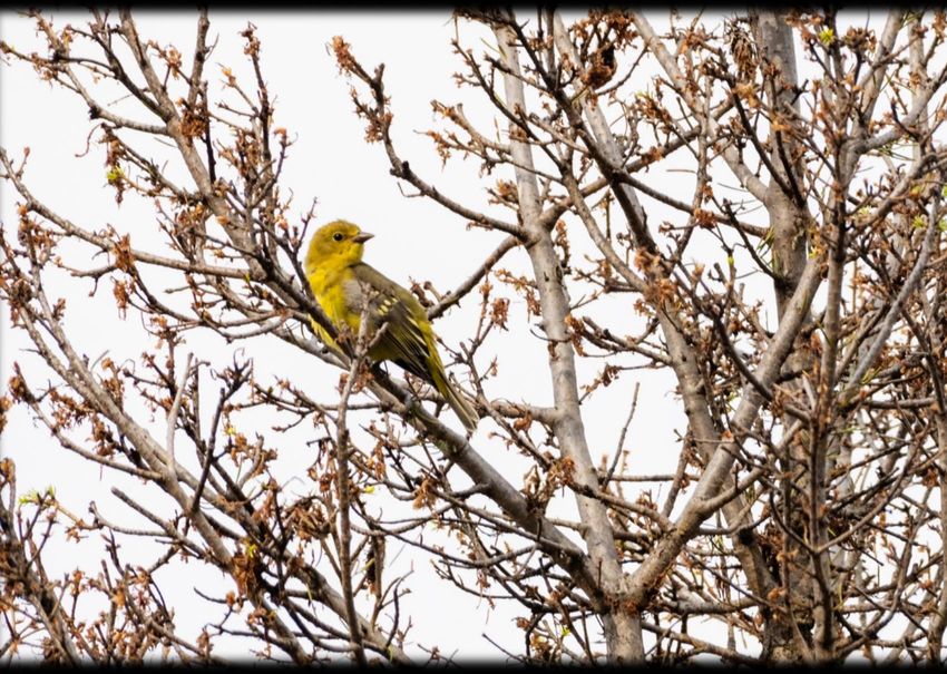
Table of Contents

Introduction......................................................................................................................................3

         Area Summary of Major Disturbance Agents.......................................................................4-8

Southern Interior Overview.............................................................................................................8

         Mountain Pine Beetle................................................................................................................8
         Douglas-fir Beetle....................................................................................................................10
         Spruce Beetle...........................................................................................................................11
         Western Balsam Bark Beetle...................................................................................................11
         Western Pine Beetle.................................................................................................................11
         Insect Defoliators - General.....................................................................................................11
         Western Spruce Budworm.......................................................................................................13
         Douglas-fir Tussock Moth.......................................................................................................21
         Western Hemlock Looper........................................................................................................26
         Gypsy Moth.............................................................................................................................32

Summaries by Timber Supply Area..............................................................................................34

         Kamloops TSA........................................................................................................................34
         Lillooet TSA............................................................................................................................37
         Merritt TSA.............................................................................................................................37
         Okanagan TSA........................................................................................................................38
         100 Mile House TSA...............................................................................................................40
         Quesnel TSA............................................................................................................................41
         Williams Lake TSA.................................................................................................................42
         Selkirk South: Arrow, Boundary, and Kootenay Lake TSAs..................................................44
         Selkirk North: Golden and Revelstoke TSAs..........................................................................45
         Cranbrook and Invermere TSAs..............................................................................................46

Forest Health Special Projects........................................................................................................48

         The Health of Young Stands…………....................................................................................48
         Trends revealed: whitebark pine in the Kootenays..................................................................51
         Studies on pests of young pine in the southern interior – a summary of two
         projects.....................................................................................................................................52
         Re-assessment of western balsam bark beetle permanent sample plots...................................63
         Douglas-fir beetle “lite” lure trapping trial in southeastern British
         Columbia…………………......................................................................................................65
         Southeastern British Columbia spruce beetle semiochemical repellent trapping bioassay….66

                        Ministry of Forests, Lands, Natural Resource Operations and Rural Development, Kamloops, B.C.
                                                                               2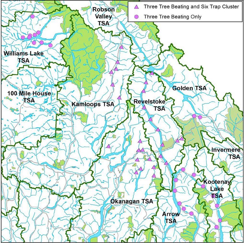
INTRODUCTION
This report summarizes the results of the 2020 Aerial Overview Surveys, forest health operations, and
research projects conducted in the southern interior of British Columbia. The aerial overview survey is
performed annually by the B.C. Ministry of Forests, Lands, Natural Resource Operations and Rural
Development and details forest damage due to bark beetles, defoliators, and other visible forest health
factors, such as foliar diseases and abiotic damage. Surveys were carried out using the standardized
Provincial Aerial Overview Survey protocols (http://www2.gov.bc.ca/gov/content/environment/research-
monitoring-reporting/monitoring/aerial-overview-surveys/methods). Polygons are used to record larger
areas of continuous damage and are assigned severity ratings as described in Table 1. Spots are used to
record small, discrete groups of affected trees.
The 2020 surveys were completed between July 8th and October 3rd. In general, flying conditions were
favorable with clear air quality due to few forest fires, but more wet weather than usual. A total of 268.3
hours of fixed-wing aircraft flying time over 53 days were required to complete the surveys, which
covered all areas within the Cariboo, Thompson Okanagan, and Kootenay Boundary Natural Resource
Regions. These three Regions cover more than 25 million hectares, of which over 15 million hectares are
forested.
The Aerial Overview mapping was conducted by trained contractors in the three Regions as follows:
Region                       Dates flown               Mappers                      Aircraft

Cariboo - south              July 8 - Aug. 1           Barbara Zimonick             Cariboo Air Ltd., C-182
                                                       Karen Baleshta
Cariboo - north              Aug. 19 - Sept. 11        Nathan Atkinson              Cariboo Air Ltd., C-182
                                                       Scott Baker
Kootenay Boundary            July 18 – Oct. 3          Neil Emery                   Babin Air, Cessna 337
                                                       Adam O'Grady
Thompson Okanagan            July 15 – July 27         Janice Hodge                 AC Airways Ltd., Cessna 210
                                                       Kevin Buxton

                  Ministry of Forests, Lands, Natural Resource Operations and Rural Development, Kamloops, B.C.
                                                               3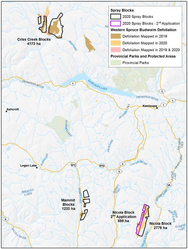
Approximately 608,753 hectares of damage were mapped over 14 TSAs during the 2020 surveys, which
is about 408,240 hectares less than was mapped in the 2019 surveys. Bark beetle infestations (western
balsam bark beetle, Douglas-fir beetle, mountain pine beetle, spruce beetle, western pine beetle, fir
engraver beetle) declined by 173,352 hectares in 2020 to 313,704 hectares, while defoliators decreased by
54% to 164,374 hectares, mainly due to the decline of aspen serpentine leafminer and western spruce
budworm.
Table 1. Severity ratings used in the aerial overview surveys.

Disturbance Type                             Severity Class            Description

Tree mortality                               Trace                     50% total defoliation
Decline Syndromes                            Light                     Decline with no mortality - the first detectable stage,
                                                                       characterized by thin crowns and no individuals
                                                                       without visible foliage

                                             Moderate                  Decline with light to moderate mortality - thin crowns
                                                                       are accompanied by individuals devoid of foliage.
                                                                       Greater than an estimated 50% of individuals have
                                                                       some foliage.
                                             Severe                    Decline with heavy mortality - crowns are very thin
                                                                       and greater than 50% of standing stems are devoid of
                                                                       foliage.
* Serpentine leafminer defoliation is rated according to the percentage of trees in the stand that are affected, based on tree mortality classes.

Abiotic damage was mapped on 89,595 hectares, a 47% decline from 2019.
This damage included foliar effects of drought, post-wildfire mortality, aspen
decline and other minor issues. Drought foliar damage declined significantly
throughout the interior, due to a second year of moist spring-summer
conditions.
Foliar disease activity increased 10-fold in 2020, with the total area mapped
being 31,311 hectares. Pine needle cast was the most prevalent, at 21,239
hectares mapped in seven TSAs, with the heaviest infestations noted in the
Kamloops, Okanagan, Boundary and 100 Mile House TSAs. Larch needle
blight, Dothistroma needle blight and minor amounts of other foliar disease
were also mapped. There were very few wildfires in 2020. Wildfires are
tracked by the B.C. Wildfire Management Branch. Small amounts of bear
damage were mapped in nine TSAs, totaling 280 hectares.

                       Ministry of Forests, Lands, Natural Resource Operations and Rural Development, Kamloops, B.C.
                                                                           4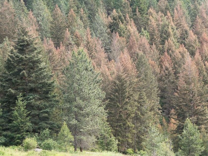
Table 2. Area affected by damaging agents in the southern interior in 2020 (patch and spot).
Timber Supply Area                                  Area of infestation (hectares)
and Damaging Agent           Trace        Light      Moderate         Severe       Very Severe         Total
Douglas-fir beetle
100 Mile House                 8,073         530              57           283                  0        8,944
Quesnel                          269         915             186            53                  0        1,423
Williams Lake                 53,130       3,383             204           365                  0       57,082
Arrow                            687       1,883           1,078           106                  0        3,754
Boundary                         504         581             565            34                  0        1,683
Cranbrook                         23          69              32            42                  0          165
Golden                            62          34             230            48                  0          374
Invermere                        357         763             688           203                  0        2,011
Kootenay Lake                    375         513             309            59                  0        1,257
Revelstoke                         0         170              37             8                  0          214
Kamloops                           3       1,226           2,902         1,601                356        6,088
Lillooet                           0          75              61           111                  2          250
Merritt                            0         240             111            98                  0          448
Okanagan                           0         931             631           403                 47        2,012
Total                         63,483      11,312           7,101         3,414                405       85,715
Spruce beetle
Quesnel                        1,667         691              10            32                  0        2,400
Williams Lake                  9,842       3,736             111            28                  0       13,718
Arrow                              0          86              30             1                  0          117
Boundary                           0          14               0             0                  0           14
Cranbrook                        390         841           1,032           387                  0        2,649
Golden                           110         478           1,089           301                  0        1,977
Invermere                        386         892           1,476           343                175        3,272
Kootenay Lake                      0         628             257             1                  0          885
Revelstoke                         0          29              34             1                  0           64
Kamloops                         877       1,672           1,470           777                233        5,029
Lillooet                           0       1,102           1,681         1,026                142        3,951
Total                         13,272      10,169           7,190         2,896                550       34,078

                 Ministry of Forests, Lands, Natural Resource Operations and Rural Development, Kamloops, B.C.
                                                              5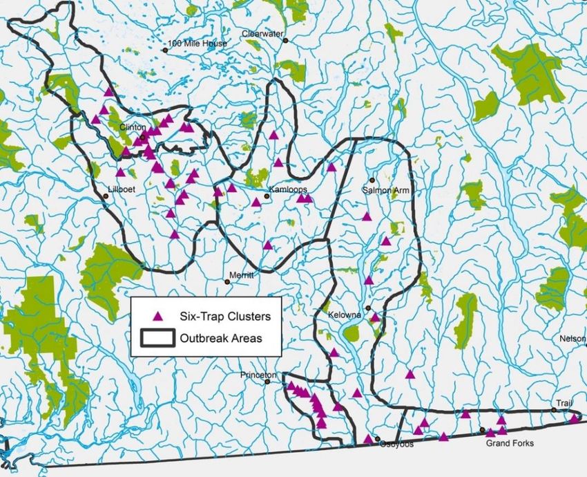
Timber Supply Area                                    Area of infestation (hectares)
and Damaging Agent           Trace        Light       Moderate       Severe     Very Severe                Total
Mountain pine beetle
Williams Lake                 32,096        3,516            1,356           14                    0        36,982
Arrow                             39           96               76           13                    0           225
Boundary                         135           11                0            6                    0           152
Cranbrook                        246          108               40           38                    0           431
Golden                           129           64               51           91                  110           445
Invermere                        997        1,374            2,162          574                  286         5,394
Kootenay Lake                    564          523              838           35                    0         1,960
Revelstoke                         0            8                0            3                    0            11
Kamloops                           0            0                0            1                    0             1
Lillooet                         348        1,633              783           70                    0         2,833
Merritt                           23           45                0            1                    0            69
Okanagan                           0           21                0            1                    0            22
Total                         34,578        7,400            5,305          846                  397        48,526
Western balsam bark beetle
100 Mile House                   632          38                32           15                     0         717
Quesnel                       25,430       3,976               296           55                     0      29,758
Williams Lake                 42,920       6,250               609           57                     0      49,836
Arrow                          1,001         324                 0            5                     0       1,329
Boundary                         298          62                 0            1                     0         361
Cranbrook                      3,150       1,001             1,311           13                     0       5,475
Golden                         5,823       4,385             1,769            8                     0      11,985
Invermere                      6,300       3,639             2,578           14                     0      12,532
Kootenay Lake                  1,717         457               185            7                     0       2,366
Revelstoke                       241         161                 0            0                     0         402
Kamloops                      11,611          89                21           74                     0      11,794
Lillooet                       8,894       2,101                24            0                     0      11,019
Merritt                        2,073           0                 0            0                     0       2,073
Okanagan                       5,551          67                 0            0                     0       5,619
Total                        115,642      22,549             6,825          249                     0     145,266
Western spruce budworm
100 Mile House                       0          7                0            0                     0            7
Williams Lake                        0      3,759            6,053          462                     0       10,274
Kamloops                             0        759              182          148                     0        1,088
Lillooet                             0        221              170            0                     0          391
Merritt                              0      2,056                0            0                     0        2,056
Total                                0      6,801            6,405          610                     0       13,816

                 Ministry of Forests, Lands, Natural Resource Operations and Rural Development, Kamloops, B.C.
                                                              6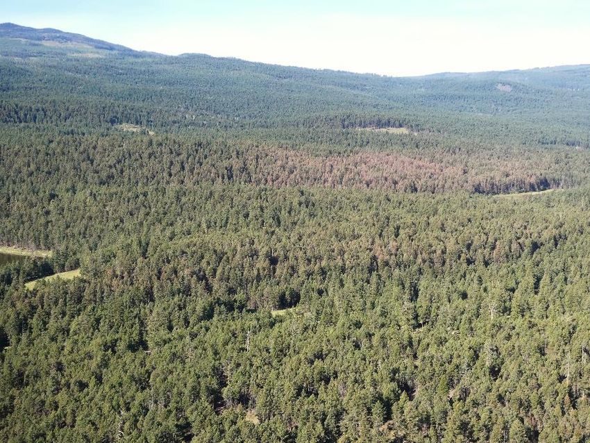
Timber Supply Area                                   Area of infestation (hectares)
and Damaging Agent            Trace        Light      Moderate      Severe     Very Severe              Total
Two-year cycle budworm                          5
100 Mile House                        0        986            215           159                   0       1,360
Quesnel                               0      2,616          3,477             0                   0       6,093
Williams Lake                         0        972            162         1,039                   0       2,173
Kamloops                              0      2,953            212            10                   0       3,174
Total                                 0      7,526          4,066         1,208                   0      12,800
Douglas-fir tussock moth
100 Mile House                        0          0                 0          29                  0           29
Williams Lake                         0          0                 0          28                  0           28
Boundary                              0          0                 0           9                  0            9
Kamloops                              0          5                 5          22                  0           32
Okanagan                              0         23                 0          10                  0           33
Total                                 0         29                 5          96                  0          130
Western hemlock looper
Williams Lake                         0    15,838             727         8,843                   0      25,408
Arrow                                 0       510             638           199                   0       1,347
Golden                                0       658             814             0                   0       1,473
Kootenay Lake                         0       764             421           260                   0       1,446
Revelstoke                            0        72               2             0                   0          74
Merritt                               0         0               4             0                   0           4
Okanagan                              0     3,135              52             0                   0       3,187
Total                                 0    20,977           2,660         9,302                   0      32,939
Aspen serpentine leafminer
100 Mile House                        0    20,329           7,950           127                   0      28,406
Quesnel                               0    15,032          24,989         2,869                   0      42,891
Williams Lake                         0     7,230           1,326           100                   0       8,656
Arrow                                 0     1,860           5,398           161                   0       7,419
Cranbrook                             0       615           2,259            84                   0       2,959
Golden                                0     3,203           3,225           210                   0       6,638
Invermere                             0     2,659           2,672             0                   0       5,332
Kootenay Lake                         0       905           2,091             0                   0       2,996
Revelstoke                            0         0           1,078             0                   0       1,078
Kamloops                              0     3,970           3,887           247                   0       8,105
Okanagan                              0       327             626             0                   0         953
Total                                 0    56,130          55,502         3,799                   0     115,432
Birch leafminer (Fenusa pusilla, Profenusa thomsoni, Lyonetia prunifoliella)
Arrow                              0         0          112          0                            0          112
Cranbrook                          0         0            5          0                            0            5
Kootenay Lake                      0         0          152         24                            0          176
Revelstoke                         0        45            0         21                            0           66
Total                              0        45          270         44                            0          359

                  Ministry of Forests, Lands, Natural Resource Operations and Rural Development, Kamloops, B.C.
                                                               7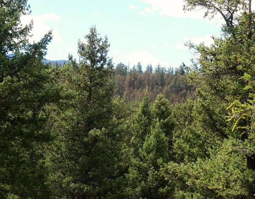
Timber Supply Area Area of infestation (hectares)
and Damaging Agent Trace Light Moderate Severe Very Severe Total
Drought - general, foliage loss
Williams Lake 0 51 50 0 0 101
Kamloops 0 2,419 193 0 0 2,612
Total 0 2,470 193 0 0 2,663
Pine needle cast
100 Mile House 0 905 29 0 0 934
Williams Lake 0 0 9 0 0 9
Boundary 0 897 0 0 0 897
Kamloops 0 9,937 2,724 0 0 12,661
Lillooet 0 340 10 0 0 350
Merritt 0 62 22 0 0 84
Okanagan 0 5,413 858 33 0 6,304
Total 0 17,555 3,652 33 0 21,239
SOUTHERN INTERIOR OVERVIEW
MOUNTAIN PINE BEETLE, DENDROCTONUS PONDEROSAE
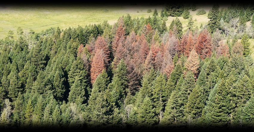
The area affected by mountain pine beetle declined by 14,723 hectares, to 48,526 hectares (Tables 2 and
3; Figures 1 and 2). The decline in area infested was seen in all TSAs except Kamloops and Merritt
where very small increases were observed. The Williams Lake TSA had the most active mountain pine
beetle, at 36,982 hectares. Invermere and Kootenay Lake TSAs still had scattered infestations but fewer
than were mapped in 2019. Seventy-one percent of all attack was trace and 26% was light to moderate.
Many of the higher elevation infestations occurred in whitebark pine or mixed species stands.
Table 3. Area infested, number of polygons, average polygon size, number of spot infestations, and
number of trees killed in spot infestations by mountain pine beetle in the southern interior, 2009-2020.
Area
Number of Average Polygon Number of Spot Number of Trees Killed
Year Infested
Polygons Size (ha) Infestations in Spot Infestations
(ha)
2009 2,342,129 23,493 100 5,745 73,994
2010 558,118 15,127 37 6,573 89,747
2011 161,012 5,999 27 4,526 56,835
2012 109,181 3,484 20 3,515 45,574
2013 63,102 1,707 40 2,905 29,670
2014 51,804 1,350 38 2,062 17,995
2015 40,045 1,180 21 1,615 15,635
2016 54,925 1,413 39 1,410 15,050
2017 25,979 717 36 860 7,960
2018 37,181 981 38 868 77,654
2019 63,249 925 68 1,415 11,771
2020 48,526 530 91 936 8,254
Ministry of Forests, Lands, Natural Resource Operations and Rural Development, Kamloops, B.C.
8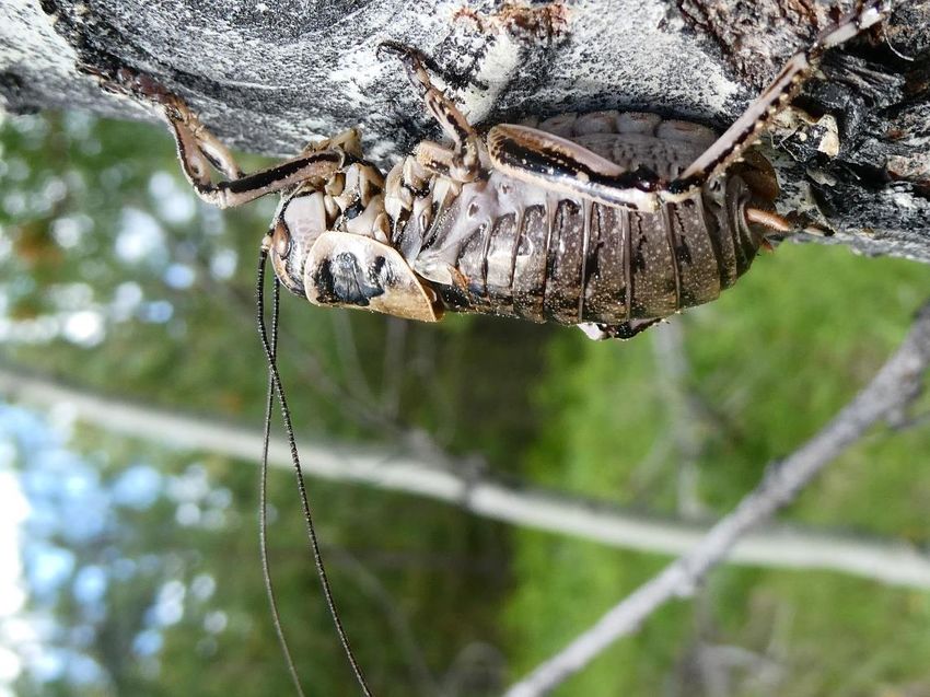
Figure 1. Timber Supply Areas and bark beetle infestations in the southern interior of B.C. in 2020.

Figure 2. Area affected by major bark beetles in the southern interior of B.C. (Cariboo, Kootenay
                 Boundary and Thompson Okanagan Regions) from 2015-2020.

           Ministry of Forests, Lands, Natural Resource Operations and Rural Development, Kamloops, B.C.
                                                        9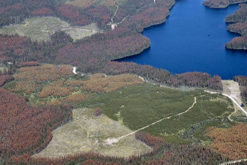
DOUGLAS-FIR BEETLE, DENDROCTONUS PSEUDOTSUGAE
Douglas-fir beetle remained widespread across many areas of southern B.C., particularly in the Cariboo
Region, where 79% of the total area of Douglas-fir beetle attack was mapped. The total area infested
increased 3,525 hectares over 2019, with the most significant increases observed in the Kamloops,
Williams Lake and Arrow TSAs. The 100 Mile House TSA saw a 27% decline with 8,944 hectares
infested in 2020, with more spot infestations and fewer large patches (Table 4). The amount of Douglas-
fir beetle recorded in the Quesnel TSA declined by 45%, yet more than doubled in the Kamloops TSA
with many of the 2020 infestations being mapped around the perimeter of the 2017 Elephant Hill Fire.
Except for the Cranbrook TSA, all others in the Kootenay Boundary Region saw small to moderate
increases in Douglas-fir beetle activity. In the Thompson Okanagan Region, infestations remained low in
the Lillooet and Merritt TSAs and declined slightly in the Okanagan TSA.
Table 4. Douglas-fir beetle infestations in the southern interior of B.C., 2019-2020.
                                Spot infestations                                    Patch infestations
 Timber                    Number              Trees                            Number             Area (ha)
 Supply Area            2019   2020       2019       2020                    2019   2020       2019       2020
 100 Mile House           429     723      2,780      4,412                    119      89      12,272       8,763
 Quesnel                  400     213      3,872      1,320                     34      17       2,582       1,396
 Williams Lake            758  1,286       6,516      8,975                    299     225      54,541     56,756
 Arrow                    272     329      3,328      5,053                    118     157       2,324       3,666
 Boundary                 101      34      1,172      1,594                     59      79       1,101       1,649
 Cranbrook                200     128      2,255      1,630                     34      12         526         132
 Golden                    24      51        383        690                      8      14         174         361
 Invermere                268     319      3,770      4,452                     82      94       1,443       1,926
 Kootenay Lake            184     225      2,064      3,222                     60      63         977       1,198
 Revelstoke                30      27        357        395                     23      12         258         207
 Kamloops                 917  1,305       7,048     11,477                    349   1,871       3,110       5,773
 Lillooet                 314     284      2,325      1,935                     30     317         188         179
 Merritt                  326     382      2,258      2,248                     54      69         407         362
 Okanagan                 950     830      7,803      6,333                    262   1,064       2,288       1,804
 Total                  5,173  6,136      45,931     55,654                  1,531   4,083      82,191     84,172

                  Ministry of Forests, Lands, Natural Resource Operations and Rural Development, Kamloops, B.C.
                                                              10
SPRUCE BEETLE, DENDROCTONUS RUFIPENNIS
The area affected by spruce beetle increased, from 30,391
hectares in 2019, to 34,078 hectares in 2020 (Table 2; Figure 2).
The most notable increases were observed in the Williams Lake
and Lillooet TSAs, with slight increases in the Quesnel,
Boundary, Golden and Kamloops TSAs.
WESTERN BALSAM BARK BEETLE, DRYOCOETES
CONFUSUS
A fifty-three percent decline in area affected by western balsam
bark beetle was recorded across the south area in 2020, impacting
145,266 hectares. All TSAs except the Golden TSA saw a
decline in western balsam bark beetle activity in 2020, although
localized infestations (e.g. Quesnel, Williams Lake, Lillooet
TSAs) are still very aggressive (Figure 2). The most significant
decreases were seen in the Kamloops, Okanagan, Williams Lake
and Quesnel TSAs (Table 2; Figure 2).
WESTERN PINE BEETLE, DENDROCTONUS BREVICOMIS
Western pine beetle activity remained low in 2020 with small patches of attack noted in eight TSAs for a
total of 129 hectares of ponderosa pine affected in the south area. Boundary (59 hectares) and Cranbrook
(28 hectares) TSAs were most affected.
INSECT DEFOLIATORS, GENERAL
Methods used to monitor defoliator populations
There are several methods used to monitor or predict defoliator populations. Brief descriptions of the
most regularly used methods are described below and more detailed information is provided within
separate defoliator sections.
Methods include:
1. Aerial overview and detailed mapping of defoliation – provides the most current information on
extent and severity of defoliation. Detailed aerial surveys are conducted when planning control
programs.
2. Annual trapping with pheromones at permanent sample sites (PSPs) – provides trends in
populations and can predict imminent defoliation. Trapping is conducted annually for Douglas-
fir tussock moth and western hemlock looper.
3. Three-tree beatings – is an assessment of species richness and abundance. This is a technique
conducted annually to collect defoliator larvae at permanent sample sites (often coupled with
trapping). Three-tree beatings are conducted at Douglas-fir tussock moth and western hemlock
looper PSPs throughout the southern interior and at an additional thirteen PSPs established in the
East Kootenays to monitor western spruce budworm and other defoliating insects.
Ministry of Forests, Lands, Natural Resource Operations and Rural Development, Kamloops, B.C.
114. Egg mass surveys – conducted late summer or fall. These surveys provide an estimate of
predicted defoliation (defoliator population) in the next season. Egg mass surveys are most often
conducted for western spruce budworm and Douglas-fir tussock moth, and occasionally western
hemlock looper, as part of the planning process for control programs.
In 2020, there was a 178,816 hectare decrease (>50%) in the area impacted by insect defoliators of
deciduous and coniferous forests in the southern interior of B.C. (Figure 3). The decrease was mostly
due to a sharp decline in deciduous defoliation, with conifer defoliation almost doubling (59,933
hectares mapped in 2020; Figure 3).
350,000
300,000
Area defoliated (hectares)
250,000
200,000
150,000
100,000
50,000
0
Deciduous
Deciduous
Deciduous
Deciduous
Deciduous
Coniferous
Coniferous
Coniferous
Coniferous
Coniferous
2016 2017 2018 2019 2020
Figure 3. Area of deciduous and coniferous defoliation in the southern interior of B.C., 2016-2020.
Three species of deciduous defoliators were observed, with the aspen serpentine leafminer
(Phyllocnistis populiella) being the most prevalent, affecting 115,432 hectares. Defoliation by the aspen
serpentine leafminer declined almost 205,000 hectares from 2019 to 2020 with the most significant
declines of between 20,000 to 80,000 hectares recorded in the 100 Mile House, Williams Lake, Quesnel
and Kamloops TSAs. Slight increases of aspen serpentine leafminer defoliation occurred in the
Cranbrook, Golden and Invermere TSAs. Satin moth (Leucoma salicis) defoliation increased to just over
400 hectares.
Six species of coniferous defoliators were recorded, with western hemlock looper (Lambdina fiscellaria
lugubrosa) being the most widespread, with over 32,900 hectares affected across the southern interior.
There was likely more defoliation by western hemlock looper than was recorded during the 2020 Aerial
Overview Surveys, due to the wet, early summer, causing foliage discoloration from feeding to be
delayed. Some Douglas-fir stands were defoliated by a combination of western hemlock looper and
western false hemlock looper (Nepytia freemani) near Kamloops. The western spruce budworm
(Choristoneura freemani) declined by 43% and was only recorded on 13,816 hectares. Noticeable
western spruce budworm defoliation declined in all TSAs in 2020, with the highest levels of defoliation
mapped in the Kamloops, Merritt and Williams Lake TSAs.
Defoliation of coniferous forests increased by 46%, to over 59,933 hectares affected in 2020, largely due
to the western hemlock looper starting its outbreak cycle and the two-year cycle budworm
Ministry of Forests, Lands, Natural Resource Operations and Rural Development, Kamloops, B.C.
12(Choristoneura biennis) being in its “on” year in the 100 Mile House, Williams Lake, Quesnel and
Kamloops TSAs. The total area mapped for this insect was 12,800 hectares.
Western spruce budworm declined in large part due to the 2020 targeted spray program in the Thompson
Okanagan Region covering large portions of the affected areas in the Kamloops and Merritt TSAs.
However, new populations continue to occur in the Cariboo and Thompson Okanagan Regions. No spray
program was conducted in the Cariboo Region in 2020 and natural declines continued in both 100 Mile
House and Williams Lake TSAs. No defoliation was mapped in the Kootenay Boundary Region in 2020.
The Okanagan TSA was the only area with pine needle sheathminer (Zellaria haimbachi) activity in
2020, with 68 hectares affected.
Douglas-fir tussock moth (Orgyia pseudotsugata) declined significantly throughout the southern
interior, with just scattered spots of defoliation mapped in the Kamloops, Okanagan, Boundary, 100 Mile
House and Williams Lake TSAs for a total of 130 hectares.
Douglas-fir tussock moth defoliation near Chase Douglas-fir tussock moth larva
WESTERN SPRUCE BUDWORM, CHORISTONEURA FREEMANI
Western spruce budworm defoliation of Douglas-fir was mapped in five TSAs in the south area in 2020
compared to seven TSAs in 2019. The total area defoliated was 13,816 hectares, a decrease of almost
10,300 hectares. The most notable decreases were observed in the Williams Lake and Kamloops TSAs
(Table 2). Only 7 hectares of defoliation was recorded in the 100 Mile House TSA, with no visible
defoliation recorded in the Boundary and Kootenay Lake TSAs.
Western hemlock looper and western false hemlock looper were observed in many of the stands where
budworm was active in the Cariboo and Thompson Okanagan Regions. The combination of these
defoliators will likely cause higher levels of defoliation in 2021 in many interior Douglas-fir stands. The
abundance of western hemlock looper coincides with marked increases in trap catches in interior hemlock
stands and the start of the next outbreak cycle (see western hemlock looper section).
The Thompson Okanagan Region sprayed 9,076 hectares of priority areas with the biological insecticide
Foray 48B (Bacillus thuringiensis var. kurstaki; P.C.P. No. 24977) in June 2020 (Figure 4; Table 5). This
targeted spray program significantly reduced the western spruce budworm spread in the Kamloops and
Merritt TSAs.
Seven blocks (Table 5) were treated over two days (June 25 and 26) with B.t.k. at 2.4 litres per hectare.
Western Aerial Applications Ltd. conducted the aerial applications using one 315B Lama helicopter and
Ministry of Forests, Lands, Natural Resource Operations and Rural Development, Kamloops, B.C.
13one Hiller UH12ET helicopter, each equipped with four Beecomist 361A ultra low volume hydraulic
sprayers. The spray operations were conducted from three staging sites where the B.t.k., mobile fuel
trucks and loading crews were positioned. The spray program was planned and implemented by the
Thompson Okanagan Region and contractor support.
Figure 4. Map showing 2020 spray blocks and 2019 and 2020 defoliation in the Thompson Okanagan
Region.
Ministry of Forests, Lands, Natural Resource Operations and Rural Development, Kamloops, B.C.
14Table 5. 2020 western spruce budworm spray blocks in the Thompson Okanagan Region showing the
treated area, litres of B.t.k. applied and date sprayed.
Spray Blocks Hectares sprayed Litres B.t.k. Date sprayed
Criss Creek West-1 257 616 June 25
Criss Creek West-2 844 2,024 June 25
Criss Creek East 3,073 7,376 June 25
Mammit North 412 988 June 26
Mammit Central 392 940 June 26
Mammit South 430 1,033 June 26
Nicola Lake West 2,780 6,671 June 26
Nicola Lake (2nd application) 889 2,134 June 26
Total 9,076 21,782
Hiller at staging site Lama spray swath over trees
Efficacy assessment
Pre- and post-spray larval sampling was done in select locations to determine larval density and B.t.k.
treatment efficacy. Pre-spray sampling was done the day before treatment, and then at 5-7 day intervals
post-spray, until the majority of budworms had pupated or were dead. No pre- or post-spray sampling
was done in the Nicola Lake blocks due to difficult access. Because areas with the highest budworm
populations received treatment, larval density was higher at the pre-spray sampling time within those
spray blocks than within the control sites (Table 6). Larval density ranged from 130 to more than 360
larvae per m2 foliage in the pre-spray sampling, comparable to numbers seen in 2019 in the Cariboo
Region spray program. At treatment, the majority of larvae were 4th instar (pre-spray, Figure 5) which is
the desired life stage for B.t.k. application. There was already some visible defoliation in the Nicola Lake
West block at the time of treatment (Figure 4) because the trees on this block were more open-grown and
feeding was more advanced. However, for about two weeks following the spray, the weather was cool
and wet, which led to reduced feeding by the budworm that somewhat affected the efficacy of the spray
treatments.
Populations declined in both treated and control areas, with the decline far more significant in treated
blocks. Mortality from the B.t.k. treatment ranged from 50% to 86% and was most pronounced in the
Criss Creek South block, where larval densities went from 180 to 22 larvae per m2 foliage (Table 6).
Ministry of Forests, Lands, Natural Resource Operations and Rural Development, Kamloops, B.C.
15Treatment blocks had much higher populations of budworm than control blocks prior to treatment with
B.t.k. Natural mortality was about 40% in the control sites. The B.t.k. spray brought larval density in
treatment blocks down to the same levels as recorded in control sites by the final assessment time.
Western spruce budworm larvae
Abbott’s corrected mortality compares the mortality caused by B.t.k. (percent mortality) to the natural
percent mortality observed in untreated control areas (Table 6). Percent mortality and Abbott’s corrected
mortality are calculated as follows:
% Mortality = (pre-spray density of live insects) - (post-spray density of live insects) x 100
(pre-spray density of live insects)
Abbott’s corrected mortality (%) = (treated % mortality) - (untreated % mortality) x 100
100 - (untreated % mortality)
Table 6. Results of pre- and post-spray larval sampling at several sites in the Thompson Okanagan 2020
spray program.
Larval density % mortality
2
(# larvae per m foliage) Uncorrected Corrected
Sample location Pre-spray 2nd post final post nd
2 post final post nd
2 post final post
Criss Creek North 190.1 104.7 38.1 46.1 73.5 41.9 76.7
Criss Creek South 179.4 90.1 22.4 46.0 86.6 48.0 86.4
Criss Creek control 132.6 72.9 37.4 37.4 39.5
Mammit 367.5 269.5 127.4 40.8 61.4 40.9 50.0
Mammit control 185.4 125.3 107.0 23.3 36.7
Ministry of Forests, Lands, Natural Resource Operations and Rural Development, Kamloops, B.C.
16Figure 5. Graph shows the percent distribution of budworm life stages at five sampling times in the Criss
Creek and Mammit Lake areas. Larval sampling at Criss Creek.
Defoliation predictions for 2021
A key part of determining whether budworm populations require treatment with B.t.k. is fall egg mass
sampling. Current, historic, and predicted defoliation (Table 7 and Figure 6) is also considered when
determining population trends and which areas are most at risk for continuing defoliation and damage.
286 sites were sampled throughout the south area for western spruce budworm egg masses (Table 7). Egg
mass sampling provides an estimate of the defoliation expected in 2021 based upon the density of egg
masses found. Of all sites sampled, 73% predicted no defoliation in 2021 and 26% had predictions of
light defoliation. No sites predicted severe defoliation, with only a few expecting moderate levels (Table
7). In the Thompson Okanagan Region, Kamloops and Merritt TSAs are the key areas where budworm
populations are active, and defoliation is expected in 2021. In the Kamloops TSA, light to moderate
defoliation is expected in the Criss Creek, Deadman and Sabiston areas northeast of Cache Creek; Barnes
Lake (budworm mixed with western hemlock looper and false western hemlock looper); and in the
Campbell-Robbins range area east of Kamloops. In the Merritt TSA, light to moderate defoliation is
expected in the Nicola Lake and Princeton areas. The average number of egg masses per 10m2 foliage
per tree in the Thompson Okanagan Region ranged from 0-55.
Egg mass surveys in the Kootenay Boundary Region are conducted annually in high priority stands that
have a history of defoliation. Eighteen sites were sampled, all in the Boundary TSA. Forty-four percent
of sites sampled yielded no egg masses (8 of 18 sites) and ten sites fell into the light category (Table 7).
The average number of egg masses per 10m2 foliage per tree in the Kootenay Boundary Region ranged
from 0-33.
Eighty-eight sites in the Cariboo Region were sampled for egg masses in the fall of 2020. Most sites
(68%) had no egg masses. Results for twenty-eight sites predicted light defoliation and no sites predicted
moderate or severe defoliation in 2021.
Ministry of Forests, Lands, Natural Resource Operations and Rural Development, Kamloops, B.C.
17Table 7. Results of the fall 2020 western spruce budworm egg mass sampling in the southern interior.
Number of sites indicating nil, light, moderate, severe defoliation in 2021 is listed by TSA with the
average number of egg masses per 10m2 foliage per tree (10 trees sampled per site) by TSA and the
maximum number found at a site. Nil = 0; Light = 1-50 egg masses; Moderate = 51-150 egg masses;
Severe >150 egg masses.
2021 predicted defoliation (No. sites) Total No. egg masses
Region and TSA Nil Light Moderate # sites Avg. Max.
Cariboo
100 Mile House 18 7 0 25 1.1 7
Williams Lake 42 21 0 63 2.5 15
Total 60 28 0 88 1.8 11
Kootenay Boundary
Boundary 8 10 0 18 7.8 33
Thompson Okanagan
Kamloops 118 26 1 145 2.7 53
Merritt 23 11 1 35 8.4 55
Total 141 37 2 180 4.6 55
Total for South Area 209 75 2 286
Proposed B.t.k. treatments for western spruce budworm in 2021 will be targeted and small, primarily
addressing stands that have a combination of budworm and loopers present.
60,000
50,000
40,000
Hectares
30,000
20,000
10,000
0
2014 2015 2016 2017 2018 2019 2020
Area sprayed (ha) Area defoliated (ha)
Figure 6. Area defoliated by western spruce budworm and area sprayed with B.t.k. in B.C. (2014-2020).
Ministry of Forests, Lands, Natural Resource Operations and Rural Development, Kamloops, B.C.
18Three-tree beating
Figure 7. East Kootenay permanent
sample plot distribution in the Rocky
Mountain Trench.
In 2007, thirteen permanent sample plots (PSP) (Table 8) formerly monitored by the Forest Insect and
Disease Survey (FIDS) unit of the Canadian Forest Service were re-established in the East Kootenays to
monitor the incidence of western false hemlock looper, Nepytia freemani and western spruce budworm,
Choristoneura freemani (Figure 7). The East Kootenays do not have history of visible defoliation by
western spruce budworm. It is possible however, that given climate change and Douglas-fir
encroachment throughout the Rocky Mountain Trench, that conditions may become favorable to the
expansion of western spruce budworm populations either from the west, or from the south.
Western spruce budworm populations remained low with one larva recorded at each of 3 sites (Golden,
Elko, and Dutch Creek), versus one larva at 1 site in 2019 (Table 8). False hemlock looper, green-striped
forest looper and western hemlock looper were the most common defoliators noted, found at 6, 4 and 5
sites, respectively. False hemlock looper populations were highest (8) at Dutch Creek. Overall insect
counts in the three-tree beatings increased from 23 larvae in 2019 to 122 larvae in 2020. No defoliation
was noted at any of the sites. Defoliator larval diversity increased, with 13 species recorded, versus 7 in
2019.
Ministry of Forests, Lands, Natural Resource Operations and Rural Development, Kamloops, B.C.
19Table 8. Insect counts from the 2020 three-tree beatings conducted in the East Kootenays.
Semiothisa s. unipunctaria
Dioryctria pseudotsugella
Nematocampa resistaria
Choristoneura freemani
Ectropis crepuscularia
Melanolophia imitata
Lambdina fiscellaria
Eupithecia olivacea
Cladara limitaria
Dichelonyx backi
Caripeta divisata
Nepytia freemani
Anoplonyx spp.
lugubrosa
PSP Location
15 Matthews FSR 2 2 1 6
19 Grasmere Dorr Road nil
21 Elko area 1
37 Norbury Lakes 26 1
39 Wildhorse River FSR 2 11 1 5 3 1
42 Wasa Sheep Creek Rd 1 1
48 Findlay Creek Road 1
50 Dutch Creek 1 2 8 2
51 Mt. Swansea Trailhead 8 2 2 1 1
52 Lillian Lake Rec Site 1 9 1 13 1
55 Horsethief FSR 1 2 1
57 Edgewater South Rd. 1 1
66 Hwy 1 West of Golden 1 2
Total 2 13 22 16 1 1 20 35 5 2 1 3 1
Ministry of Forests, Lands, Natural Resource Operations and Rural Development, Kamloops, B.C.
20DOUGLAS-FIR TUSSOCK MOTH, ORGYIA PSEUDOTSUGATA
In 2019, the Douglas-fir tussock moth began another outbreak cycle in the southern interior, with
numerous single-tree epizootics and patches of defoliation recorded for a total of 2,708 hectares.
However, in 2020, there was a dramatic decline in the total area of active tussock moth defoliation, most
notably in the Williams Lake TSA, where only 28 hectares of defoliation was mapped compared to 1,662
hectares in 2019. Small pockets of defoliation were also recorded in the 100 Mile House, Kamloops,
Okanagan and Boundary TSAs (Table 2). The Okanagan TSA saw a sharp decline in active populations
with only small patches mapped near Vernon, Chase-Falkland Road and Kelowna. The populations in the
south portion of the TSA near Anarchist Mountain collapsed due to the presence of a natural virus in the
population.
Douglas-fir tussock moth larva and defoliated stand at Chase-Falkland Road and Hwy. 1 intersection
The proposed 2020 spray program (20,000 hectares) in the Williams Lake TSA near Dog Creek, using
B.t.k., was cancelled due to very low to nil viable Douglas-fir tussock moth numbers in the spring of
2020. Throughout the spring and early summer of 2020, field assessments were conducted in areas where
tussock moth egg masses were located to monitor for larval hatch and dispersal. Over 4 weeks of
monitoring, no visible hatch was observed from egg masses. Branch clipping and branch beatings were
also conducted to evaluate the abundance, diversity and stage of defoliators present in stands. Most trees
sampled did not produce any tussock moth larvae. Where tussock moth larvae were present, they were in
very low abundance (1-3 per branch beating) and at 3rd instar or larger. At this stage of development,
defoliation should have been visible if insect density was high. Numerous western hemlock looper larvae
were collected from branch beatings.
A helicopter reconnaissance flight conducted in the last week of June to access more remote locations and
to look for signs of defoliation, yielded no defoliation within the area proposed for B.t.k. treatment. Some
very small pockets of defoliation were mapped on private land.
This population collapse was most likely due to virus (nuclear polyhedrosis virus) infection and adverse
climatic conditions (winter kill, cool spring weather). This was the most northerly record of Douglas-fir
tussock moth defoliation in B.C. and although changing, milder climatic conditions may have allowed
this insect to reach outbreak levels, it is still at the edge of its climatic range.
Ministry of Forests, Lands, Natural Resource Operations and Rural Development, Kamloops, B.C.
21Small patches of Douglas-fir tussock moth defoliation were mapped west of Blue Lake near Hwy. 3 and
northeast of the Kelowna airport in the Okanagan TSA. In the Kamloops TSA, small patches were
detected on private land near the Pritchard rodeo grounds, at the junction of Chase-Falkland Road and
Hwy. 1, east of Smith Road in Falkland and near Blackwell Road in the Barnhartvale area.
Annual monitoring with six-trap clusters
The last Douglas-fir tussock moth outbreak collapsed in 2012. From 2012 through 2015, trap catches
declined to very low levels until 2016, when a slight increase in the average number of male moths caught
was observed in all Outbreak Areas. Outbreak periodicity varies by Outbreak Area (geographic location)
and can range from 5 to over 40-year intervals between outbreaks. Typically, in the southern interior, we
experience an outbreak in one or more of the Outbreak Areas every decade. When a consistent upward
trend is found in a stand for 2 to 3 years (average over 10 moths per trap), or if an average of 25 moths or
more per trap has been caught, ground surveys for egg masses are recommended and defoliation may
occur the next summer.
Douglas-fir tussock moth lures from three chemical companies were deployed in 6-trap clusters at each
trapping site between 2016 and 2018, to compare the efficacy of the three lure types in attracting tussock
moth and accurately predicting imminent outbreaks: Scotts® (Solida); WestGreen Global Technologies
(ChemTica); and, Synergy Semiochemicals® (Figure 8). Scotts® is now no longer supplying the same
lure, so only two lures have been used since 2019. All lures have a loading of 5µg pheromone. In 2020,
two lines (one line per lure supplier) of 6 traps each were set at each trapping site in the Thompson
Okanagan (39 sites) and Cariboo (14 sites) Regions. The Kootenay Boundary Region had 14 trapping
sites (an increase from 8 sites) and used only the WestGreen Global Technologies (ChemTica) lure.
There was some variation among average trap catches each year by the ChemTica and Synergy lures, but
both were good at predicting defoliation events and/or increases in tussock moth population in the general
area where traps were placed.
In the Kamloops Outbreak Area, 5 of the 9 trapping sites had a decline in the average number of moths
caught in 2020. The Heffley Creek, Six Mile and Monte Creek trapping sites had an increase over 2019
with high trap catches for two or more consecutive years (Table 9). In the Okanagan Outbreak Area, 5
sites had low or declining moths catches and 3 sites had moderate to high trap catches (Wood Lake,
Kaleden, and Glenmore). Five of the 10 sites in the Similkameen Outbreak Area had lower trap catches
than in 2019 and 4 sites had slight increases. The small outbreaks seen in 2019 in this area collapsed due
to the natural virus. In the West Kamloops Outbreak Area, 6 sites captured fewer moths than in 2019,
while 5 sites had moderate increases in trap catch. Highest trap catches were in the Veasy Lake area,
north of Cache Creek. There may be small patches of defoliation in 2021, but it is unlikely that
significant areas will be affected in the remaining year or so of this outbreak cycle.
Douglas-fir tussock moth and western hemlock looper caught in sticky trap
Ministry of Forests, Lands, Natural Resource Operations and Rural Development, Kamloops, B.C.
22Table 9. Average number of Douglas-fir tussock moths caught per 6-trap
cluster in the Thompson Okanagan and Cariboo Regions (2016-2020). In
the Thompson Okanagan and Cariboo Regions, lures from three suppliers
(Scotts (Solida), ChemTica (WestGreen Global Technologies), and
Synergy Semiochemicals) were compared in 2016-2019. In 2020 Scotts
lures were not available. The Kootenay Boundary Region uses ChemTica
(WestGreen Global Technologies) lures.
Average Douglas-fir tussock moth catch per site*
Site Location (Outbreak Area) 2016 2017 2018 2019 2020
Kamloops (KA)
1 McLure 5.5 8.9 10.9 21.2 6.5
2 Heffley Creek 26.6 26.8 32.4 18.6 40.4
3 Inks Lake 0.1 0.1 0 0.2 0
4 Six Mile 3.4 3.8 9.9 23.1 32.3
9 Stump Lake 0 0.3 0.1 1.3 0
10 Monte Creek 3.8 6.4 7.8 20.1 30.3
11 Chase 1.7 0.3 3.4 5.9 2.0
48 Haywood-Farmer 9.6 20.3 2.6
49 Buse Lake 5.4 14.1 14.5
Average of 9 sites 5.9 6.7 8.8 13.7 14.3
Okanagan (OK)
12 Yankee Flats 3.2 0.5 2.3 1.2 2.4
13 Vernon 1.4 5.3 0.4 0.1
14 Wood Lake 7.6 17 41.3 17 31.2
15 June Springs 0.5 1.1 2.0 2.7 0.1
16 Summerland 0.7 0.9 0.3 1.6 0.1
17 Kaleden 4.9 6.2 4.4 7.5 12.1
18 Blue Lake 11.5 17.3 34.4 18.3 1.7
45 Glenmore 5.3 9.0 25.4 20.1 19.5
Average of 8 sites 4.8 7.1 14.4 8.6 8.4
Similkameen (SIM)
19 Stemwinder Park 8.6 8.2 29.8 - 18.1
32 Olalla 21.2 21.6 40.4 29.1 23.3
33 Red Bridge 8.8 7.4 9.3 9.4 10.9
38 Hwy 3 Bradshaw Creek 17.7 10.3 29.2 36.8 22.1
39 Hwy 3 Winters Creek 7.6 7.6 27.7 17.4 13.8
40 Hwy 3 Nickelplate Road 8.8 9.7 31.3 18.7 21.7
41 Stemwinder 11.4 34.2 26.5 13.0
42 11.8 km Old Hedley Rd 0.3 0.4 2.0 3.8 1.8
43 Pickard Creek Rec Site 5.5 6.8 31.6 14.5 20.2
44 5.7 km Old Hedley Rd 3.9 4.3 20.4 7.6 10.8
Average of 10 sites 9.5 8.8 26.0 18.2 15.6
Ministry of Forests, Lands, Natural Resource Operations and Rural Development, Kamloops, B.C.
23Average Douglas-fir tussock moth catch per site*
Site Location (Outbreak Area) 2016 2017 2018 2019 2020
West Kamloops (WK)
5 Battle Creek 0.3 0.7 0.9 no access no access
6 Barnes Lake 2.5 9.9 7.7 25.4 16.2
8 Pavilion 1.6 7.7 7.1 20.7 4.4
21 Spences Bridge 2.5 7.3 8.6 9.4 10.1
22 Veasy Lake 9.7 burned 1.7 13.7 16.2
24 Veasy Lake 6.2 burned 6.7 25.0 18.6
26 Venables Valley 0 1.4 0.2 4.6 5.9
27 Maiden Creek 0.2 1.0 1.6 6.6 8.1
28 Hwy. 99 2.2 6.1 9.2 28.6 39.9
31 Barnes Lake 0.6 2.1 0.8 9.1 1.4
46 Barnes Lake Road. 2.2 11.2 2.4
47 Stinking Lake 0.3 6.8 0.5
Average of 12 sites 3.5 4.5 3.8 14.6 11.3
Boundary (KT) (14 sites in 2020) 0.6 1.3 2.3 5.0 8.9
Cariboo (CAR) (14 sites in 2020) 1.6 2.4 1.8 5.0 0.5
Figure 8. Location of Douglas-fir tussock moth 6-trap clusters throughout the southern interior.
Ministry of Forests, Lands, Natural Resource Operations and Rural Development, Kamloops, B.C.
24The City of Kamloops monitors Douglas-fir tussock moth populations in five city parks having natural
settings of Douglas-fir throughout the city. All locations except the Peterson Creek Park site had average
trap catches above the threshold. Kenna Cartwright Park, Dallas Barnhartvale Nature Park (Eliza Road),
Juniper Park and Sunrise Mountain Park (Ronde Lane) averaged 28-34 moths per trap per site.
Fourteen permanent trapping sites are monitored in the Kootenay Outbreak Area (Boundary). Four
trapping sites caught over 10 tussock moths per trap in 2020 (Harrison and Johnstone Creek). Overall, an
average of 8.9 moths per 6-trap cluster was caught in 2020, an increase from 2019. Monitoring will
continue but it is unlikely there will be significant defoliation in 2021.
Figure 9. Average number of Douglas-fir tussock moths caught per 6-trap cluster at 8 permanent trapping
sites in the Kootenay Boundary Region (2014-2020).
Three-tree beatings
Three-tree beating is a procedure for sampling defoliating forest insect larvae, which involves beating the
foliage and collecting the fallen insects on a tarpaulin. Three-tree beating provides temporal and spatial
information on the richness and diversity of defoliating insects and is conducted in late June to early July
each year.
In the Thompson Okanagan Region, Douglas-fir tussock moth larvae were found in five sites, similar to
2019 (Table 10), but the average number of larvae per positive site was lower at 2.1, compared to 9.2
larvae/positive site in 2019. Larvae were found near sites that were defoliated in 2019 or 2020 (Heffley,
Barnhartvale, west Kamloops, central Okanagan). All other sites sampled were negative. In the
Kootenay Outbreak Area, no Douglas-fir tussock moth larvae were found at any of the 9 sites (Table 10).
Douglas-fir tussock moth was the most common defoliator found in the Thompson Okanagan, followed
by western hemlock looper, western spruce budworm and an assemblage of other insects. There was a
change in 2020 of the species assemblages in both regions and slightly lower numbers overall. Western
hemlock looper increased in the Kootenay Boundary but decreased in abundance in the Thompson
Okanagan from 2019. Western spruce budworm was only found at one site in 2020 (Johnstone Creek) in
the Kootenay Boundary Region and at two sites in the Thompson Okanagan (Heffley, Chase).
Ministry of Forests, Lands, Natural Resource Operations and Rural Development, Kamloops, B.C.
25Table 10. Dominant insects recorded in the 2020 three-tree beatings in the Kootenay Boundary (9 sites),
Thompson Okanagan (28 sites) and Cariboo (30 sites) Regions. The total number of insects and number
of sites where insects were found is recorded.
Green-striped forest looper
Sawflies (Neodiprion spp.)
Looper (Nepytia freemani)
(Choristoneura freemani)
Western spruce budworm
Douglas-fir tussock moth
Western hemlock looper
Western False Hemlock
(Orgyia pseudotsugata)
(Melanolophia imitata)
(Lambdina fiscellaria
Region
lugubrosa)
Kootenay Boundary
Total insects 1 12 12 16 20 8
No. sites 1 1 4 4 3 4
Thompson Okanagan
Total insects 17 2 34 80 1 11
No. sites 8 2 9 13 1 7
Cariboo
Total insects 2 654 557 0 1 2
No. sites 2 14 27 0 1 1
WESTERN HEMLOCK LOOPER LAMBDINA FISCELLARIA LUGUBROSA
In 2020, defoliation by western hemlock looper was mapped on 32,939 hectares in seven TSAs within the
southern interior (Table 2) an increase of 31,865 hectares over 2019, marking the first year of this new
outbreak cycle. Most defoliation was mapped in the Williams Lake TSA on 25,408 hectares, followed by
the Okanagan TSA with 3,187 hectares mapped. The Arrow, Golden and Kootenay Lake TSAs all had
over 1,300 hectares of defoliation, with Revelstoke TSA at 74 hectares. No defoliation was mapped in
hemlock stands in the Kamloops TSA during the Aerial Overview Survey, but there were reports later in
the summer of visible defoliation in Wells Gray Park near Clearwater Lake. Defoliation by western
hemlock looper was confirmed in the Inks Lake, Beaton Creek and Barnes Lake areas in Douglas-fir
stands. In the Okanagan TSA, defoliation was mapped affecting hemlock in the North Shuswap south of
Pukeashun Park, and near Perry River, Mt. Griffin, Crazy Creek and Josh Mountain. In the Kootenay
Boundary Region, numerous small to moderate size areas of defoliation were recorded near Cummins
River, Kinbasket drainage, Illecillewaet River, Beaver River, Duncan River, Trout Lake and others.
Western hemlock looper and associated defoliators are
monitored annually at permanent sampling sites using a
combination of three-tree beatings and/or moth trapping (six uni-
traps placed per site) (Figure 10). Three-tree beatings and moth
trapping were done at 16 sites in the Thompson Okanagan
Region. In the Kootenay Boundary Region, three-tree beatings
were done at 25 sites, while moth trapping was done at 10 of the
sites. In the Cariboo Region, three-tree beatings were done at 20
sites, while moth trapping was done at 16 sites (Figure 11).
Ministry of Forests, Lands, Natural Resource Operations and Rural Development, Kamloops, B.C.
26Three-tree beatings were done at an additional 10 sites in the Quesnel Lake area. Three-tree beatings were
undertaken in early to mid-July at all sites and traps were placed at this time. A 60 cm x 90 cm drop cloth
and a 2.5 meter pole were used to conduct the tree beatings. Traps were collected late September through
early October 2020. In addition to the trapping and three-tree beatings, fall ground reconnaissance was
conducted in the Kamloops TSA in Interior Douglas-fir sites to estimate moth populations. Of the 107
sites assessed, 35 sites had no evidence of hemlock looper moths, 37 sites had very light populations, 25
sites had light populations and 10 sites had moderate populations. Most of the western hemlock looper
and false hemlock looper populations observed in these surveys were located from Inks Lake west to
Barnes Lake in low to mid-elevation mature Interior Douglas-fir stands.
Western hemlock looper defoliation in Douglas-fir near Inks Lake (left) and hemlock in the North Shuswap (right)
The average number of western hemlock looper moths caught per trap is trending upward (Table 11,
Figure 12) from a 5-year period of minimal catches between 2013 and 2017. Average trap catches per
site increased at 11 sites in the Thompson Okanagan and 13 sites in the Kootenay Boundary (Table 11).
Sites with the highest average moth catch per trap in 2020 include Scotch Creek (844 moths); Crazy
Creek (660 moths); Greenbush Lake (724 moths); Shuswap River (848 moths); and, Adams/Tum Tum
(716 moths) in the Thompson Okanagan. Goldstream River had an average of 1,631 moths; Downie
Creek (2,387 moths); (Begbie Creek (1,283 moths); Kinbasket Lake (967 moths); and Pitt Creek
Recreation Site (1,555 moths) in the Kootenay Boundary Region (Table 11). Defoliation was visible at
several sites in 2020 in both hemlock-dominated and Interior Douglas-fir-dominated stands. Notable
defoliation was recorded in 2018 and 2019 near Baker Lake in Washington State to the south. In the
Cariboo Region, the average number of western hemlock looper moths caught per trap was 137 moths,
ranging from an average of 3 to 828 moths per trap (Figure 11). Three-tree beatings were conducted at 20
sites in the Cariboo Region. All 20 sites yielded western hemlock looper moths (average 15 moths per
site); 14 sites had western spruce budworm and 2 sites had Douglas-fir tussock moth. Trapping for
western hemlock looper has now been conducted through one complete outbreak cycle into the next
cycle. This has provided data to support a reliable early warning system for imminent outbreaks.
Ministry of Forests, Lands, Natural Resource Operations and Rural Development, Kamloops, B.C.
27Figure 10. Locations of western hemlock looper permanent sampling sites in southern British Columbia.
Western false hemlock looper larva and moth Western hemlock looper larva and moth
Ministry of Forests, Lands, Natural Resource Operations and Rural Development, Kamloops, B.C.
28Figure 11. Map showing western hemlock looper trapping results and three-tree
beating sites in the Cariboo Region.
Table 11. Average number of western hemlock looper moths caught per six-trap cluster in the Thompson
Okanagan and Kootenay Boundary Regions, 2012-2020.
Average moth catch per trap
Site # Location 2012 2013 2014 2015 2016 2017 2018 2019 2020
Thompson Okanagan Region
1 Serpentine River 26 3 2 6 1 9 18 38 448
2 Thunder River 79 6 7 34 2 34 146 107 489
3 Mud Lake 52 4 1 13 1 14 294 120 549
4 Murtle Lake 88 8 3 25 3 51 134 316 533
5 Finn Creek 35 5 2 13 0 14 43 237 356
7 Scotch Creek 705 44 11 20 4 34 311 222 844
8 Yard Creek - 175 33 141 17 72 29 145 121
9 Crazy Creek 410 30 21 41 2 32 143 146 660
10 Perry River North 197 59 29 58 10 - 302 197 289
11 Three Valley Gap 240 53 21 50 8 55 234 291 314
12 Perry River South 410 70 29 33 8 30 156 233 128
13 Kingfisher Creek 732 80 43 55 27 50 241 211 260
14 Noisy Creek 450 117 106 107 12 47 128 178 88
15 Shuswap River 411 46 26 49 6 49 161 422 848
16 Greenbush Lake 1,530 83 20 23 11 81 140 515 724
17 Adams River/Tum Tum 501 12 8 41 0 39 84 119 716
Average of sites 391 50 22 44 7 41 160 219 460
Ministry of Forests, Lands, Natural Resource Operations and Rural Development, Kamloops, B.C.
29Average moth catch per trap
Site # Location 2012 2013 2014 2015 2016 2017 2018 2019 2020
Kootenay-Boundary Region
66 Sutherland Falls 222 40 21 2 1 - 72 235 1,195
72 Tangier FSR 390 110 23 19 1 19 98 56 196
73 Martha Creek 281 105 31 3 3 23 86 33 439
74 Goldstream River 597 137 23 2 3 42 55 257 1,631
75 Downie Creek 743 86 24 9 9 9 35 246 2,387
76 Bigmouth Creek 645 38 2 2 1 26 25 88 375
78 Carnes Creek 518 66 7 5 3 15 8 257 766
83 Begbie Creek 557 171 23 11 0 50 97 658 1,283
84 Pitt Creek Rec. Site 865 13 6 4 2 50 60 342 1,555
85 Kinbasket Lake 304 83 4 9 2 20 145 518 967
87 Jumping Creek 201 36 4 3 5 41 68 NA -
Average of sites 484 80 15 6 3 29 68 269 1,079
1000
Average # moths per 6-trap
900
800
700
600
cluster
500
400
300
200
100
0
2003 2005 2007 2009 2011 2013 2015 2017 2019
Figure 12. Average annual western hemlock looper moths per 6-trap cluster site (±Standard Error) in the
Thompson Okanagan Region 2003-2020. Yellow highlights last outbreak cycle.
In the Kootenay Boundary Region western hemlock looper larvae were found in 96% of sites visited in
2020 (23 of 24 sites) up from 92% of sites in 2019. However, the number of western hemlock looper
larvae increases 9-fold in 2020 for a total of 492 insects recorded (Table 12). The highest counts were at
Box Lake, Sutherland Falls, Downie Creek, Begbie Creek and Pitt Creek Recreation Site, ranging from
35 to 84 insects per site (Table 12). The assemblage of insects remained stable but there was also a
significant increase in the number of sawflies found in 2020. In the Thompson Okanagan Region western
hemlock looper larvae were found in 88% of sites visited in 2020 (14 of 16 sites) down from 94% of sites
in 2019. The total number of western hemlock looper larvae recorded overall remained static, with the
highest number recorded at the Three Valley Gap-Wap Creek site (29 insects; Table 12).
2020 marked the first year in another outbreak cycle of western hemlock looper. Spray programs using
B.t.k. are planned for all three southern interior regions in 2021. Approximately 66,000 hectares have
been delineated (TOR=29,000 ha; KBR=7,000 ha; CAR=30,000 ha) for treatment in early July 2021.
Ministry of Forests, Lands, Natural Resource Operations and Rural Development, Kamloops, B.C.
30Most proposed spray blocks are located in mature western hemlock where tree mortality is predicted if
they are not sprayed. In the Thompson Okanagan Region, proposed blocks are in both mature western
hemlock stands and Interior Douglas-fir stands, where a combination of western hemlock looper, western
false hemlock looper and western spruce budworm have been identified.
Table 12. Results from the 2020 three-tree beatings at permanent sample sites located in areas of historic
western hemlock looper defoliation in the Kootenay Boundary and Thompson Okanagan Regions. The
table shows the total number of specimens of the dominant insect species collected.
(Lambdina fiscellaria lugubrosa)
Black-headed budworm (Acleris
Filament Bearer (Nematocampa
Western False Hemlock Looper
Gray Forest Looper (Caripeta
Saddleback Looper (Ectropis
Green-striped forest looper
Western Hemlock Looper
(Melanolophia imitata)
Sawflies (Neodiprion,
(Nepytia freemani)
crepuscularia)
Anoplonyx)
gloverana)
resistaria)
divisata)
Site # Location
Kootenay Boundary
30 Keen Creek 25 4 1 1 3
38 Hills 22 2 9 1 9 3
58 Halfway River 19 15 1
61 Box Lake 46 2 2 3 30 15
62 Kuskanax Creek 19 3 15 13 5
65 Shelter Bay Ferry 10 8 1 1
66 Sutherland Falls 84 15 2
69 Quartz Creek 0
70 Gerrard 9
71 Trout Lake 3
72 Tangier FSR 28
73 Martha Creek 28 10
74 Goldstream River 9 4
75 Downie Creek 35
76 Bigmouth Creek 19 18
78 Carnes Creek 22
79 Lardeau FSR 3 12
80 Meadow Creek 6 12 1
81 Schroeder Creek 5 8 1
82 Beaton 8 2
83 Begbie Creek 38 3
84 Pitt Creek Rec Site 42 10
85 Kinbasket Lake 10
86 Beaver River 2
Total insects 492 7 128 7 45 0 40 18
Ministry of Forests, Lands, Natural Resource Operations and Rural Development, Kamloops, B.C.
31You can also read