Situation analysis of Mukdahan Special Economic Zone
←
→
Page content transcription
If your browser does not render page correctly, please read the page content below
i

 Situation analysis of Mukdahan Special
             Economic Zone

     Submitted to Thailand Environmental Institute

Supported by Urban Climate Resilience in Southeast Asia
     Prepared by Assistant Prof. Dr. Arika Bridhikitti
    Faculty of Environment and Resource Studies,
          Mahasarakham University, Thailand
                    July 15, 2016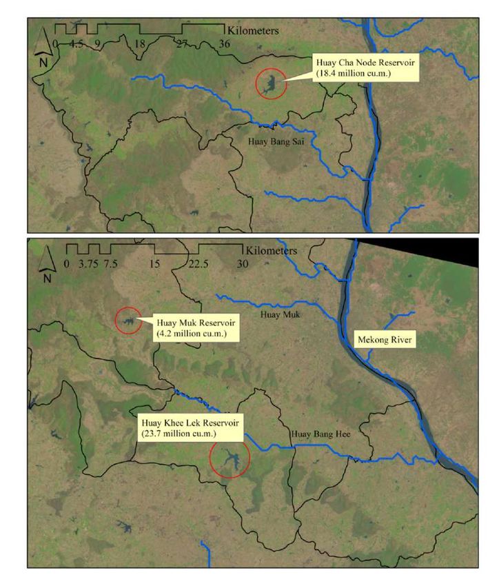
ii
Table of Contents
Chapter 1
Understanding urban system of the Mukdahan Special Economic Zone .................................................................... 1
1.1. Introduction to Mukdahan Special Economic Zone .................................................................................. 1
1.2. Geography and land covers ...................................................................................................................... 2
1.3. Demography and administration .............................................................................................................. 5
1.4. Economics ............................................................................................................................................... 6
1.5. Infrastructure ........................................................................................................................................... 7
1.6. Natural Resources .................................................................................................................................... 9
1.7. Environmental situation ......................................................................................................................... 12
1.8. Security issues ....................................................................................................................................... 13
1.9. Strategic Plans and Policies ................................................................................................................... 13
Mukdahan Development Plan for years 2014 to 2018 ..................................................................................... 13
Provincial Industrial Strategic Plan for 2016 to 2021 ...................................................................................... 14
Provincial Natural Resources and Environmental Management Plan for years 2016 to 2021 .......................... 15
Provincial Agricultural and Cooperative Development Plan for years 2013 to 2016 ....................................... 15
Chapter 2
SWOT analysis for Mukdahan ................................................................................................................................ 16
2.1. Local civilian’s reflection on problems and urgent needs ....................................................................... 16
2.2. SWOT analysis ...................................................................................................................................... 16
Chapter 3
Key Issues of Vulnerability to Climate Change and Adaptive Actions .................................................................... 19
References .............................................................................................................................................................. 26
Appendices
In-depth interviews
SLD gallery
iii

                                                               Table of Figures

Figure 1 Administrative map of Mukdahan Province and MSEZ .............................................................................. 1
Figure 2 Map of EWEC pathway to the South China Sea and major cities along the roadway ................................... 2
Figure 3 Topological map of Mukdahan ................................................................................................................... 2
Figure 4 Existing conserved forests, National Parks, community areas and floodplains in MSEZ ............................. 3
Figure 5 Conceptual framework for MSEZ land use development plan ..................................................................... 4
Figure 6 Proposed land use plan for MSEZ ............................................................................................................... 5
Figure 7 Some tourist attractions in Mukdahan ......................................................................................................... 7
Figure 8 Proposed transportation plan for MSEZ ...................................................................................................... 8
Figure 9 Areas of community forests by district ........................................................................................................ 9
Figure 10 Agricultural land covers by district ......................................................................................................... 10
Figure 11 The Mekong River, its tributaries and major reservoirs ........................................................................... 11
Figure 12 Average rainfall and temperature for Mukdahan ..................................................................................... 12
Figure 13 Kham A-Huan Investment Zone ............................................................................................................. 14
Figure 14 Mukdahan SLD in 24th May, 2016 .......................................................................................................... 20
Figure 15 Significant linear regression of monthly meteorology from 2000 to 2016................................................ 21
Figure 16 Hydrological changes associated with climate change ............................................................................. 22
iv

                                                                    Table of Tables

Table 1 Mukdahan administration ............................................................................................................................. 5
Table 2 Estimated water utilizations in Mukdahan (unit: million m3 year-1) .............................................................. 8
Table 3 Water resources and serviced areas by district ............................................................................................ 10
Table 4 Goals and indicators set in Mukdahan development plan ............................................................................ 13
Table 5 List of urgent needs and key problems reflected by local people in each district in Mukdahan Province ..... 18
Table 6 Summary on Climate change patterns from the SLD .................................................................................. 20
Table 7 Matrix on significance and severity of potential issues of vulnerability in MSEZ ....................................... 23
Table 8 Summary on current actions, obstacles and recommendations of future works ........................................... 24
v

                                          Acknowledgement

                                           กิตติกรรมประกาศ
คณะผู้วิจัยขอขอบคุณเครือข่ายโครงการพันธมิตรเพื่องานวิจัยด้านการรับมือของเมืองในเอเชียตะวันออกเฉียงใต้
ต่อการเปลี่ยนแปลงสภาพภูมิอากาศ (Urban Climate Resilience in Southeast Asia Partnership: UCRSEA)
ที่ให้การสนับสนุนงบประมาณดาเนินงานวิจัยระยะเวลา 5 ปี (พ.ศ.2557-2562) โดยเลือกเขตเศรษฐกิจพิเศษ
มุกดาหารเป็นหนึ่งในเมืองศึกษานาร่องของประเทศไทย กิจกรรมโครงการดัง กล่าวมุ่งเน้นสร้างศักยภาพของ
งานวิจัยด้านการกลายเป็นเมืองที่มีความเชื่อมโยงกันในระดับภูมิภาคและการเปลี่ยนแปลงสภาพภูมิอากาศ เพื่อ
เพิ่มความเข้าใจเรื่องความเปราะบางของคนเมือง และเสริมสร้างการรับมืองของเมือง ในปีที่ 2 นี้ คณะผู้วิจัยได้
ศึกษาบริบทและสถานการณ์ปัจจุบันของเขตเศรษฐกิจพิเศษมุกดาหาร ประกอบด้วยการทาความเข้าใจระบบเมือง
การวิเคราะห์ระบบเมือง และการบ่งชี้ประเด็นความเปราะบางต่อการเปลี่ยนแปลงสภาพภูมิอากาศที่สาคัญ รวมถึง
การศึก ษากิจกรรมการปรับ ตัวต่อประเด็น เปราะบางดั ง กล่าว การศึ กษานี้ มุ่ง เน้ น ศึกษาจากรายงานราชการ
สิ่งพิมพ์ และสื่อ รวมถึงการสัมภาษณ์เชิงลึก และวิเคราะห์ของภาคส่วนที่เกี่ยวข้องผ่านการประชุมเชิงปฏิ บัติการ
ผลที่ได้จากการศึกษานี้จะใช้ต่อยอดและเป็นกรอบการดาเนินการวิจัยในพื้นที่เขตเศรษฐกิจพิเศษมุกดาหารในปี
ต่อไป
ผู้วิจัยขอขอบพระคุณหน่วยงานราชการทุกภาคส่วนในจังหวัดมุกดาหาร โดยเฉพาะอย่างยิ่ง พณท่าน สรสิทธิ์ ฤทธิ์
สรไกร ผู้ว่าราชการจังหวัดมุกดาหาร, คุณไพบูลย์ รัตนะเจริญธรรม ผู้อานวยการสานักงานทรัพยากรธรรมชาติและ
สิ่งแวดล้อม จังหวัดมุกดาร และ คุณกุศล ภูวภรณ์กุล เจ้าหน้าที่สานักงานอุตสาหกรรม จัง หวัดมุกดาหาร ที่ให้
ความอนุเคราะห์ช่วยเหลือและเสนอแนะตลอดระยะเวลาการรวบรวมข้อมูลและดาเนินกิจกรรมปีที่ 2 นี้

                                                      (ผู้ช่วยศาสตราจารย์ ดร เอริกา พฤฒิกิตติ)
                                                ผู้รับผิดชอบโครงการวิจัยเขตเศรษฐกิจพิเศษมุกดาหาร
                                                อาจารย์ประจาคณะสิ่งแวดล้อมและทรัพยากรศาสตร์
1

                                                   Chapter 1
            Understanding urban system of the Mukdahan Special Economic Zone
1.1.    Introduction to Mukdahan Special Economic Zone
The Mukdahan Special Economic Zone (MSEZ) is a section of the Mukdahan province, lying between 16 − 17 oN
latitude and 104 – 105oE longitude in Northeast Thailand. The MSEZ comprises three districts and 11 sub-districts,
covering an area of 578.5 km2 (see Figure 1). The three districts are Muang Mukdahan (5 sub-districts are Sri Boon
Rueng, Mukdahan, Kham A-Huan, Na Sri Nuan and Ban Sai Yai), Don Tan (2 sub-districts are Don Tan and Pho
Sai) and Kwan Yai (4 sub-districts are Kwan Yai, Pong Kham, Ban Sai Noi and Chanode).

                          Figure 1 Administrative map of Mukdahan Province and MSEZ

Due to its location on the border with Lao PDR, Mukdahan has a high potential for investors, both in tourism and in
border trade. Mukdahan is located in the middle of the East−West Economic Corridor (EWEC), connected to
Sawannakhet, Lao PDR by the 2nd Thai-Laos Friendship Bridge. As seen from Figure 2, the EWEC starts in Moh La
Mang city in Myanmar, enters Thailand at Mae Sod city, connects Sawannakhet, Lao PDR at Mukdahan, Thailand,
passes the Sawan-Seno Special Economic Zone, Lao PDR and the Lao Bao Special Economic Zone, Vietnam, and
enters the Southern China Sea at the Da Nang pier, Vietnam. From the Da Nang pier, products can be transferred via
cargo ships to arrive at Hanoi, Vietnam and Southern China. With a population of ~100 million people, Nan Ning,
China is one of the region’s major cities, and could potentially be the key distributor of products from Thailand
(Mukdahan Administration Office, 2016).
There are three dimensions of investment targeted in the MSEZ. The first dimension is to offer support
manufactures of the products potentially for exported, which are computer hardware, vehicle gears, petrol, plastic
wares, etc. The second dimension is to support agricultural-based manufacturing products, including cargoes and
industries relating to rice, sugarcane, cassava and Para rubber. Finally the third dimension is to promote tourism
investment and give support to service sectors, which includes a plan to increase the number of medical centers,
international schools, hotels and housing estates (Mukdahan Administration Office, 2016).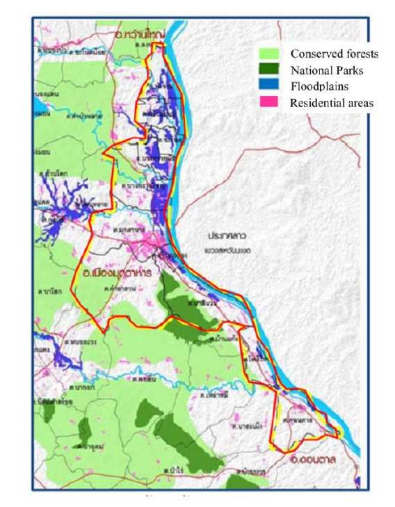
2

           Figure 2 Map of EWEC pathway to the South China Sea and major cities along the roadway

                        Source: Department of Public Works and Town Planning (2016)
1.2.    Geography and land covers
As seen from Figure 1, Mudahan shares its northern border with the province of Nakhon Panom, connects with the
province of Sakon Nakhon to the northwest, and shares its southern border with three provinces of Yasothron,
Amnart Charoen and Roi Et. These parts of Mukdahan province are characterized by flat highland (shown in Figure
3). The Western border, connecting to Kalasin province, is dominated by hilly forests while eastern Mukdahan is
adjacent to the Sawannakhet Province, Lao PDR, where the border is divided by the Mekong River (Mukdahan
Administration Office, 2016).

                                    Figure 3 Topological map of Mukdahan

Proposed by the Department of Public Works and Town Planning (2016), land uses and land covers in the MSEZ
area of 578.5 km2 will consist: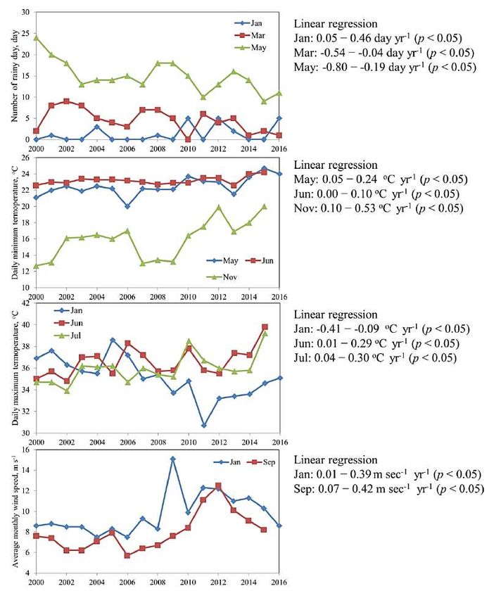
3

    1.   Community areas, mainly growing along road networks,
    2.   National Parks and conserved forests, covering part of both Phu Pha Tupe National Park and Phu Dok Bua
         National Park,
    3.   Water resources, including the Mekong River, Huay Bang Sai, Huay Bang Hee etc.,
    4.   Floodplain areas, exhibiting fertile soil attributed to deposition of river sediment,
    5.   Agricultural areas for rice cultivation, vegetable farms, croplands and fruit plantations.
Within this area, 58.73% of the land have a title deed, 15.53% are in National Parks or conserved forests, 10.42%
are agricultural lands issued by the Agricultural Land Reform Office , 8.66% are in cooperative estates, 3.5% are
state property lands and 3.26% are other public areas (Mukdahan Industrial Office, 2016).

          Figure 4 Existing conserved forests, National Parks, community areas and floodplains in MSEZ
                          Source: Department of Public Works and Town Planning, 2016
The Department of Public Works and Town Planning (2016) delineates conceptual framework for land uses in the
MSEZ as illustrated in Figure 5; the framework is described below:
    1.   Multiple centers to decentralize urbanization from cities to surrounding areas
    2.   Developing new functioning land uses and supporting existing land uses in order to facilitate economic
         development.
    3.   Balance between economic development zones, green areas, cultural preservation areas and high-quality
         agricultural lands.
    4.   Interconnection among community centers and outers.
The Department of Public Works and Town Planning (2016) has also set approaches for urban land use planning for
three districts in MSEZ; Muang Mukdahan District, Don Tan District, and Kwai Yai District. The details are shown
in Figure 6. Muang Mukdahan District aims to be a center of commercial investments, logistics, governance,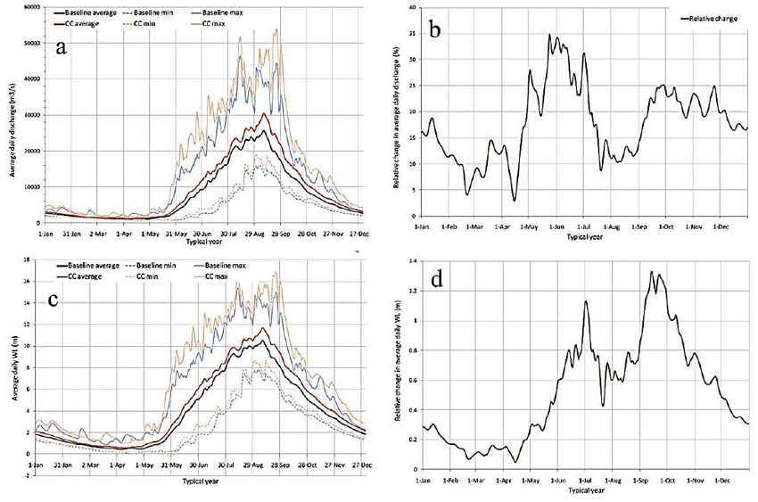
4

training, hotels and services for tourists. Potential functioning land uses in this district are commercial and service
zones, including shopping malls and wholesale and retail stores, hotels and resorts, exhibition centers,
meeting/conference centers, occupational learning centers, public transportation terminals, residential zones, logistic
parks and cargo and eco-industrial centers. Kwan Yai District is potentially a center of logistic and product
distribution, as well as ecotourism communities. Functioning land uses in this district could be new residential
zones, new commercial zones and services, transportation terminals, hotels/resorts/ guesthouses for tourism
purposes, center of fine art and culture, eco-industries and cargo, and retail-sale businesses. Don Tan District is
planned to be centers of agricultural productions, household-scale industries and fine products under the “One
Tambon One Product (OTOP)” brand. Communities in Don Tan District are lower population density and its
functioning land uses are expected to be centers of agricultural products, handicrafts and OTOP, small-scale
agriculture-relating industries, community commerce, local-wisdom learning centers, and agricultural development
centers (Department of Public Works and Town Planning, 2016).

                       Figure 5 Conceptual framework for MSEZ land use development plan
                          Source: Department of Public Works and Town Planning (2016)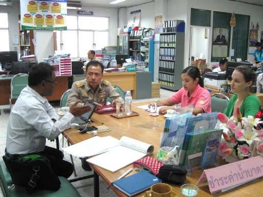
5

                                    Figure 6 Proposed land use plan for MSEZ
                         Source: Department of Public Works and Town Planning (2016)
1.3.    Demography and administration
As updated in December 2015, the total population in Mukdahan is 348,101, comprised of 174,394 males and
173,707 females. Approximately 38% of the total population is living in Muang Mukdahan. Population growth rate
has decreased since 2004, and was at 0.386% as updated in December, 2015. Birth rate is 10.61:1,000 and death rate
is 6.18:1,000. The majority of people in the province are Buddhist (96.8%) and are primarily rooted from 8 tribes;
which are Phu Thai, Thai Yo, Thai Kha, Thai So, Thai Kaloeng, Thai Saek, Thai Kula, and Thai Isaan (Mukdahan
Administration Office, 2016). There are several unique well-known cultural events relating to their faiths both
Buddhist and local tribal customs. Furthermore, there has been a significant increase in the number of Thai of
Vietnamese decent living in Mukdahan since the Vietnamese War, approximately 70 years ago.
6
Major household careers in urban area of Mukdahan are labor (21.66%), followed by trader (17.51%); whereas the
major careers in the suburbs are rice farmer (55.44%) and labor (10.73%). Among three districts in MSEZ, Muang
Mukdahan District has proportionally fewer agricultural sectors (47.7%); whereas both Don Tan District and Kwan
Yai District have agricultural households as the majority (~78%). Average annual income of people in MSEZ is
87,499 baht per capita for those in Muang Mukdahan District, and much lesser in Kwan Yai District (66,136 baht
per capita) and Don Tan District (63,169 baht per capita) (Mukdahan Administration Office, 2016).
Thai governance structure can be divided into two systems, provincial administration and local administration. The
provincial administration includes both province and district, while typical local administration comprises
municipality, sub-district administration organization (SAO) and provincial administration organization (PAO). The
provincial administration of Mukdahan Province is comprised of 7 districts, as detailed in Table 1. The local
administration of Mukdahan Province governs 24 municipalities and 30 SAOs (Mukdahan Industrial Office, 2016).
Table 1 Mukdahan administration
Distance to Population*, Sub-district
Area Town Sub-district
District Town Hall, capita Administration
(km2) Municipality Municipality
km Organization
Khamcha-I 1,235 33 47,289 1 9 3
Dong Luang 377 55 37,259 - 2 6
Don Tan 85 33 42,729 - 2 2
Nikhom Kham Soi 511 28 42,887 - 3 5
Muang Mukdahan 713 3.5 130,077 - 1 9
Nong Sung 410 50 20,771 - 3 2
Kwan Yai 1,076 35 18,824 - 3 3
Total 339,836 1 23 30
Source: Mukdahan Industrial Office (2016)
* updated in September 30, 2011
1.4. Economics
Mukdahan’s economy relies heavily on agricultural-related sectors and the distribution of products/services. The
MSEZ development is currently focusing on both industrial and transportation sectors; whereas tourism and
infrastructure sectors are growing slowly. Gross provincial production (GPP) of Mukdahan is largely from non-
agricultural sectors (75.81% in 2013), including wholesale and retail stores (16.65% in 2013) and that of industries
(15.05%). The key products are wholesale foods and clothes (19.55% in 2013), automobiles (26.85%), petrol
(18.73%) and goods sold in shopping malls (6.66%). The key industrial sectors in 2013 were Para rubber-derived
productions (10.03% in 2013), food and beverage industries (78.78%), including rice mills (28.07%) and sugarcane
production (33.88%). In 2013, the agricultural sectors accounted for 24.19% of the total GPP in Mukdahan, largely
from rice (42.86%), followed by Para rubber (20.81%), cassava (14.81%) and sugarcane (12.40%) (Mukdahan
Industrial Office, 2016). GPP growth in infrastructure sectors (water supply and power) highly fluctuates, depending
upon international power trading policy (Mukdahan Industrial Office, 2016).
In the year 2012, border trade was valued at 109,566.46 million baht, of which 64,336.64 million baht was from
exported products, primarily electronic appliances, computer devices, vehicle gears and petrol. The majority of
imported product was pure copper sheet. In the year 2013, border trade value decreased to 67,790.8 million baht,
resulting from the opening of the 3rd Thai-Laos Friendship Bridge in Nakhon Panom Province. (Mukdahan
Administration Office, 2016). Not only in Mukdahan but also in other provinces located along the national
borderline, local people do not gain much benefit from the border trade since the majority of trading products do not
come from the Northeast Region. The Mukdahan Chamber of Commerce suggests adding value to local agricultural
products, focusing on organic agricultures, and the promoting of cultural-based tourism (PRACHACHART
TURAKIT, 25-28 February, 2016).
Tourism industries, including hotels and restaurants, were only accounting for 1.42% of the GPP (in 2013) and have
been growing slowly. Tourism industries generated 1,811.59 million baht in 2013. Several of the major visiting
spots of the province are historical landmarks (temples and monuments), national parks (the Mekong River, Phu Pha
Tupe National Park, Taad Toon Waterfall, Manopirom Beach, Huay Kee Lek Reservoir, etc.). There are also several
artificial visiting spots, such as the 2nd Thai-Laos friendship bridge, the Indochina market and cultural villages, etc.7
As a part of tourism, each district develops their own signature products under the “One-Tambon-One-Product,
OTOP” brand, which include woven-bamboo products, naturally-dyed scarves, handmade shirts, mud-dyed textile
and plastic-woven baskets. The OTOP however, only accounted for less than 1% of total GPP in 2013 (Mukdahan
Administration Office, 2016).
The 2nd Thai-Lao Friendship Bridge
Figure 7 Some tourist attractions in Mukdahan
Source: http://www.touronthai.com/
1.5. Infrastructure
To meet the set goals for MSEZ, large infrastructure development projects are currently ongoing, such as an
extension of highway No. 12 and a construction of twin-trail train line, linking Khon Kaen (Ban Pai district),
Mahasarakham, Roi Et, Mukdahan and Nakhon Panom. In the long term, the government plans to extend highway
No. 212 from Kwan Yai (Mukdahan) to Nakhon Panom and to improve city road networks, as well as to establish
transportation terminals. The MSEZ transportation plan proposed by the Department of Public Works and Town
Planning (2016) is shown in Figure 8. In years 2015 to 2016, The Thai government aims to spend 1,889 M THB for
the development of transportation systems (806 million THB), checkpoints/customhouses (100 million THB), an
industrial estate (15 million THB) and public utilities (968 million THB). Currently there are two national airports
adjacent to Mukdahan, which are Sakhon Nakhon and Nakhon Panom. Furthermore, Mukdahan Commercial
Chamber is proposing for the renovation of old Leong Nok Tha military airport in Yasothorn Province to become
commercial airport in order to support high population influx and greater economic development (DAILYNEWS,
29th April 2016).8
Figure 8 Proposed transportation plan for MSEZ
Note: dash lines represent proposed road lines and solid lines represent existing road lines
Source: Department of Public Works and Town Planning (2016)
The Electricity Generating Authority of Thailand has currently two high-voltage (22,000 volt) power stations in the
Mukdahan, producing approximately 40 million watt day-1 of which 10 million watt day-1 comes from the biomass
power plant, using biomass residues from the Saharuean sugarcane industry. Power supply in MSEZ is claimed to be
sufficient due to a current surplus of power generation (Mukdahan Administration Office, 2016).
The Provincial Water Work Authority (PAAW) is the major water provider in Mukdahan province, taking the raw
water supply from the Mekong River. Total production rate of the PAAW is 1,070 m3 hr-1,which service to 12,569
peoples (Mukdahan Administration Office, 2016). This water supply is not sufficient for MSEZ development.
PAAW is searching for land of approximately 2.4 ha near the 2 nd Thai-Lao friendship bridge for the construction of9
a new water supply plant, and also has a plan for an expansion of the old water plant in fiscal year 2016 (Mukdahan
Industrial Office, 2016).
There are 18 man-made reservoirs with a total retention volume of 82.42 million m3 and a total surface area of 74.3
km2 (Mukdahan Administration Office, 2016). These reservoirs are servicing approximately 215.25 km2 of irrigated
area. Furthermore, 345 groundwater wells have been registered, 56% of which are located in Muang Mukdahan
District, primarily used for domestic consumption (59%) (Mukdahan Administration Office, 2016). Estimated public
demands for water utilization in Mukdahan are detailed in Table 2.
Table 2 Estimated water utilizations in Mukdahan (unit: million m3 year-1)
Domestic consumption and
Industries Agriculture
tourism
Mekong River and its tributaries
Year Year Year
Year 2011 Year 2025 Year 2011
2025 2011 2025
Mekong River Section 9 1.14 1.31 0.04 0.05 47.60 62.66
Huay Ban Sai 1.75 2.44 0.04 0.05 35.22 55.41
Huay Muk 5.17 5.95 0.42 0.52 41.22 113.64
Huay Bang Hee 2.15 2.45 0.07 0.08 26.98 65.32
Lower Mekong River 5.89 2.27 0.21 0.26 105.79 293.28
Source: Office of National Resources and Environment (2016)
1.6. Natural Resources
Mukdahan province is rich in mountains and forest.
The Phupan Range is in the eastern part of the
province and the West-Southwest is mainly flat
highlands alternating with hilly terrain. These areas
are covered with deciduous and dry dipterocarp
forests (43.75% of the total area), and the area
includes 3 national parks, 13 conserved forests and
other small parks including a wildlife sanctuary, a
botanical garden and a non-hunting area (Mukdahan
Administration Office, 2016). Map of major forest
resources in the MSEZ are illustrated in Figure 9. The
Forestry Cooperative Center, Mukdahan is working
to restore and expand community forests. This type
of forest has a role to play in cultural preservation
and social well-being for the local communities. The
forests are located adjacent to communities and could
be used as foods and fuel resources, as well as
sources of wood for housing construction and
cemetery land.
Sediment soil in Mukdahan province is in the Korat
soil series, comprising of sandstone with minor silt,
clayey and salt layers on the top. Besides this, there
are low-grade copper ore resources scattered over the
area. The majority of top soil texture in Mukdahan is Figure 9 Areas of community forests by district
loam to sandy loam with medium to low nutrients Source: Department of Public Works and Town
(45%), found in the flat highlands. This soil can be Planning (2016)
appropriated for cultivating dry crops. Thirty three
percent is steep hilly terrain, not appropriate for cropping due to a risk of ecosystem deterioration. Twenty percent is
poor drainage soil, suitably used for rice cultivation (Mukdahan Administration Office, 2016). Rice fields and field
croplands; such as corn, sugarcane and cassava, are the primary agricultural land covers in Mukdahan. Agricultural
land proportions are shown in Figure 10. Approximately 75% of the total 4,339.83 km2 of soil found in Mukdahan
Province has been identified as acidic soil, 11.9% of which is in complex steep terrain, and 3.8% being infertile
gravel land, which results in low productive yield (Office of Agriculture and Cooperative, 2016).10
Figure 10 Agricultural land covers by district
Source: Office of Agriculture and Cooperative (2016)
Average rainfall in Mukdahan is 1,740 m3 year-1 and surface runoff is 12.65 to 15.08 l sec -1 km-2 on average. The
Mekong River is the major water supply in Mukdahan, passing three districts; Muang Mukdahan, Kwan Yai and
Don Tan. Its tributaries are Huay Muk, Huay Bang Sai, Huay Bang Hee and Huay Cha Node (see Figure 11). These
water resources are used in agricultural production and domestic consumption, as well as in fisheries, tourism,
transportation, and river sand suction industries. Mukdahan has an abundance of freshwater wetlands, including 539
riverine wetlands, 4 lake wetlands and 229 swamps (Office of National Resources and Environment, 2016). Besides
the natural water resources, there are large agricultural areas receiving irrigation service from artificial reservoirs
and electric pumping stations along the Mekong River. These reservoirs include Huay Khee Lek Reservoir in the
Nikhom Kham Soi District (23.37 million m3), Huay Cha Node Reservior in the Dong Luang District (18.4 million
m3) and Huay Muk Reservior in the Khamcha-I District (4.2 million m3). There are also 21 small reservoirs and
check dams, and 33 water pumping stations functioning as agricultural irrigation. A summary of these water
resources and areas are detailed in Table 3.
Table 3 Water resources and serviced areas by district
Irrigated areas under serviced by artificial
Natural water water resources, km2
District
land cover, km2 Reservoirs and Electrical water
Check Dams pumping stations
Khamcha-I 0.968 3.690 -
Dong Luang 5.461 48.400 2.080
Don Tan 3.294 1.920 22.688
Nikhom Kham Soi 1.451 16.040 -
Muang Mukdahan 3.323 6.880 19.216
Nong Sung 0.550 - -
Kwan Yai 0.157 - 24.544
15.204 76.930 68.528
Source: Office of Agriculture and Cooperative (2016)11
Figure 11 The Mekong River, its tributaries and major reservoirs
Mukdahan's climate is classified as tropical wet and dry or savanna climate (Aw), based on the Kӧppen climate
classification system. These climates have a pronounced dry season, with the driest month having precipitation less
than 60 mm and less than 1/25 of the total annual precipitation. Its summer season starts anywhere from mid-
February to mid-May while the rainy season is from mid-May to mid-October, and the winter season is from mid-
October to mid-February. The average annual temperature here is 26.3 °C. Annual precipitation averages 1,456 mm
(Climate-Data.org, 2016). The driest month in Mukdahan is December, having average rainfall of 2 mm and the
wettest month is August (316 mm) (Climate-Data.org, 2016).12
Figure 12 Average rainfall and temperature for Mukdahan
Adapted from Climate-Data.org (2016)
1.7. Environmental situation
Average solid waste produced by Mukdahan’s households is 0.6 kg person-1 day-1, and the total solid waste
generation is approximately 212.2 ton day-1. These solid wastes comprise of organic waste (60%), paper (9.4%),
plastic (9.4%), glass (3.0%), metals (5.4%) and other. In Mukdahan Province, there is only one sanitary landfill at
Sri Pattana community, Mukdahan Sub-District, Muang Mukhahan District, approximately 5 km from the city
center (see Figure 5). Only 30 tons of solid waste per day from Muang Mukdahan District and five municipalities is
disposed into this sanitary landfill. Other municipalities are either burning wastes in open fields (14 municipalities)
or sending wastes to non-sanitary landfills (4 municipalities) (Office of Natural Resources and Environment, 2016).
Furthermore, Mukdahan is currently searching for a new sanitary landfill to dispose of solid waste, the amount of
which has been significantly increasing along with MSEZ development (Mukdahan Administration Office, 2016).
The Office of Natural Resources and Environment (Mukdahan), together with the Regional Environment Office in
Ubonratchathani, is responsible for natural water and air quality monitoring. The water quality (reported in 2014) in
the Mekong River, Huay Cha Node, Huay Bang Hee, Huay Bang Sai was classified as Type 3 freshwater,
appropriately used as raw water for domestic water supply. However, water quality in the Huay Muk and Huay
Khee, receiving wastewater from Muang Mukdahan’s communities, has been classified as poor to very poor quality
(Type 4−5 freshwater), exhibiting low levels of dissolve oxygen ( 4,000 MPN
per 100 ml) and high ammonia (> 0.5 mg l-1). These poor water qualities result from direct discharge of domestic
wastewater from communities and lack of public knowledge on water quality management. Currently, there is one
wastewater treatment plant (using a stabilization pond system) located in Muang Mukdahan District. The wastewater
collection grid, however, does not cover the entirety of Muang Mukdahan. The air quality in Mukdahan is within
acceptable levels. Traffic emissions are the major source of air pollution in the city of Mukdahan, while open
biomass burning is the major contributor from the agricultural zones (Office of Natural Resources and Environment,
2016).
Significant problems for environment and natural resources in Mukdahan are broken into four major fields, which
are 1) soil and land uses, 2) forest resources, 3) solid waste and 4) water resource (Office of Natural Resources and
Environment, 2016). Problems resulting from soil and land uses are infertile soil, soil erosion along riverbanks, and
contamination of toxic agricultural chemicals into the soil. These problems are predominant in agricultural lands and
in the Mekong River’s bank in Muang Mukdahan, Kwan Yai and Don Tan Districts. Problems affecting forest
resources include forest degradation, deforestation, cutting of trees, forest land conversion, forest fires, and illegal
hunting of wildlife animals and the harvesting of wild plants. Affected forest areas are found in 13 national
conserved forests, 3 national parks, Phu Sri Than Wildlife Sanctuary, Pha Nam Thip Cave Non-Hunting Area, Dong
Bang Hee Forest Park, Dong Bang Hee Botanical Garden, as well as in community forests. Solid waste problems are
found at all municipality scales. The problems include high solid waste generation and accumulation, non-sanitary
solid waste disposal systems, public objection to construction of a solid waste disposal plant, poor public13
participation in solid waste management, and inappropriate disposal of infected wastes. Problems affecting water
resources include degradation of surface water quality, insufficient water for domestic consumption and agriculture,
flood resulting from a poor drainage system, lack of public participation, and ineffective water management.
1.8. Security issues
Drug use is one of the major security issues present in Mukdahan. In 2011, there are 1,792 suspects involved in
cases of drug use (35.2% of all on-going cases), and 2,796 suspects involved in the cases during 2011 (40%). Drug
use prevention and drug control became the first priority in the provincial security plan. Implementation programs
include empowerment of communities, medicating of drug-addicted victims, prevention of drugs in schools,
enforcement of drug-related regulations, and collaboration with Lao PDR to control the trans-boundary drug trades.
(Mukdahan Administration Office, 2016).
The illegal trans-boundary trade between Mukdahan and Sawannakhet in Lao PDR comprises mainly of agricultural
products, such as garlic and onion from China. Due to the long borderline (72 km) along the Mekong River and
many unofficial piers, it is difficult to control the illegal trade across the country boundary (Mukdahan
Administration Office, 2016).
Due to limited labor forces in Mukdahan, alien labor is in high demand. As updated in July 2013, the total number
of registered alien laborers in Mukdahan is 746, of which 640 are from Lao PDR, 33 from Myanmar and 1 from
Cambodia. There are also, however, a significant number of illegal laborers entering Thailand from both Lao PDR
and Myanmar. Some of these alien laborers were also victims of human trafficking (Mukdahan Administration
Office, 2016).
1.9. Strategic Plans and Policies
Mukdahan Development Plan for years 2014 to 2018
Mukdahan’s governor envisioned the latest development plan of Mukdahan as one that would see it becomes “the
city of commerce, agriculture and Mekong’s tourism, connecting with ASEAN” and three key goals have been
defined as follow;
1. to promote economic growth by increasing competencies in agriculture, border trade and tourism,
2. to improve quality of life by reinforcing social security along the borderline, and
3. to conserve and restore natural resources and environment and promote power security.
The following table outlines the goals with the set indicators for year 2019 (Mukdahan Administration Office,
2016).
Table 4 Goals and indicators set in Mukdahan development plan
Goals Indicators (by year 2019)
To promote economic growth by GPP increase of 20%
increasing competencies in GPP from agricultural sector increased by 20%
agriculture, border trade and International trade value increase of 28% (7% per year)
tourism Tourism income increase of 20% (5% per year)
Deprivation ratio decreased to 7%
Average academic achievement increased to 10 years of
To improve quality of life by schooling
reinforcing social security along Average O-NET score increased to 50% and up for all
the borderline levels
Death rate for firstborn baby decreased to < 4 per 1000
babies
To conserve and restore natural
resources and environment and Forest cover increased by at least 1%
promote power security
The following strategies are defined to assisting in achieve the goals:
1. Development of agriculture and agriculture-based industries14
2. Commercial gate connecting ASEAN to worldwide markets
3. Development of tourism business to promote community incomes
4. Human and social development to improve quality of life
5. Natural resource protection nd environmental management
6. Reinforcement of social security
Provincial Industrial Strategic Plan for 2016 to 2021
Mukdahan’s industrial plan is currently looking towards green industries, sustainability and the targeting of ASEAN
Plus markets (ASEAN countries + China, Japan, and South Korea). The plan aims to increase the capabilities and
competencies of medium-and small-scale industries, as well as community-based industries, and to boost
investments in concordance with industrial developments in the neighboring AEC countries (Mukdahan Industrial
Office, 2016). High land selling prices of approximately 7 to 10 million baht per rai (1rai = 0.0016 km2) results in
lower attraction to investors and be one of the major obstacles for MSEZ development. To resolve this problem,
central government will establish an investment zone in Kham A-Huan Sub-district, Muang District, covering an
area of 1.736 km2 (1,085.5 rai).
Figure 13 Kham A-Huan Investment Zone
Source: Rhitsorakhai (2015)
The Broad of Investment (BOI) envisions the MSEZ as a“Center of wholesale and retail stores, and logistics,” and
has set for the MSEZ 10 BOI-targeted industries. These are 1) agriculture, animal foods and fisheries, 2) electrical
appliances and electronics, 3) industrial estates, 4) logistic services (including cargo, terminal and vehicle), 5)
metals-based structures for construction or industries, 6) construction devices, equipment, and reinforced concrete
products for public works (excluding ceramic products), 7) printing services, 8) cosmetics and body-care products,
9) plastic wares for households and 10) pulp-derived products. Under the MSEZ development plan, government will
provide essential infrastructure in the MSEZ, including roads, train lines, airport, truck terminals, power grid and
supply, water supply and treatment, public works, communication facilities, custom checkpoints, borderline
infrastructure, environmental management, and city landscape and tourism spots. Furthermore, the BOI offers
several advantages for those investors and industries settling in MSEZ. The advantages include the granting of tax
subsidies, and tax exemptions, the skilled labor registration for aliens, and land and property rights.
Department of Industrial Works (2016) is currently conducting a study for an “MSEZ Eco-Industrial Park Master
Plan.” The results of this study show two prerequisites needed for the Eco-Industry. The first requirement is a
gathering database, which are in accordance with Eco-Industry regulations for conducting material and energy mass
balances. The second requirement is a defining of spatial-specific business models and conducted activities or
projects carried out in response to the Eco-Industrial Development Indicators. The working committees in charge of
the “MSEZ Eco-Industrial Park Master Plan” have primarily agreed to drive forward on 6 strategies under the Eco-
Industrial Park Master Plan (Department of Industrial Works, 2016).
1. Conduct surveys of appropriate land uses/city layouts for different areas (which are dense industrial area,
developing industrial area and special economic zone).
2. Improve essential infrastructure to support socio-economic development
3. Improve environmental management and safety15
4. Development of connection between community bases and industries in the area
5. Improve social and public well-being
6. Develop systems for knowledge dissemination and human resource development
Provincial Natural Resources and Environmental Management Plan for years 2016 to 2021
Mukdahan’s plan for natural resource and environmental management is divided into three major sectors, which are
the 1) natural resource sector, 2) inland water resource sector and 3) environmental problem sector. For natural
resources, the forest resource is the most important in terms of severity and urgent requirements for execution,
followed by soil and land uses, wildlife, biodiversity and wetlands. For the inland water sector, the most important
problem is degradation of the freshwater ecosystem, followed by that of insufficient water for domestic consumption
and agriculture. For environmental problems, the most important issues are solid wastes, followed by hazardous
wastes, poor water quality and air pollution, respectively.
There are several governmental agencies tackling these problems in MSEZ.
The Forestry Cooperative Center, Mukdahan, and the Office of Forest Resource Management (Region 7, Khon
Kaen) are responsible for multiple afforestation projects in MSEZ public areas, including those in urban zones
and community forests. These projects aim to increase green spaces, improve public well-being and raise public
awareness on the topic of forest resource conservation.
Among the eleven Sub-District Municipalities in MSEZ, Na Sri Nuan Sub-district Municipality (in Muang
Mukdahan District) and Kwan Yai Sub-District Municipality (in Kwan Yai District) play vital roles in
conserving community forests and water resources in their areas of responsibility. The Na Sri Nuan Sub-District
Municipality leads projects on dissemination of forest conservation knowledge, afforestation in areas of
degraded forests, and training for fire-fighting volunteers. The Municipality also plans to promote bio-friendly
agriculture to minimize chemical use and also spend budget for new solid waste incineration technology and a
wastewater collection system. Similar forest conservation projects have been conducted in Kwan Yai Sub-
District under the Royal initiative of Her Majesty the Queen. The Kwan Yai Sub-District also leads several
urban green projects, including improving green landscapes and integrated solid waste management, focusing
on public participation. Biogas technology is one of the solid waste management options in the realm of the
Municipality’s projects. Furthermore, the Kwan Yai Sub-District Municipality is also interested in using wind
power as an alternative energy for agricultural water translocation.
The Office of Natural Resources and Environment, Mukdahan, and the Office of Environment Region 12 have
been responsible for several projects, collaborating among multiple stakeholders, such as schools, navy, and all
Sub-District Municipalities. The project activities include 1) long-term water quality monitoring, focusing in the
Mekong River and its tributaries, 2) long-term air pollution monitoring in the Muang Mukdahan District, 3)
Raising public awareness on global warming and 4) long-term monitoring on effects of in-river sand suction
businesses.
Provincial Agricultural and Cooperative Development Plan for years 2013 to 2016
Mukdahan has set its vision on provincial agricultural development, aspiring towards “self-reliant farmers, quality
production, safe foods, and the ASEAN market.” To achieve these goals, four strategies have been implemented.
First strategy involves strengthening farmers and farmer organizations to become smart farmers by means of
knowledge dissemination, hygienic foods promotion, and the assisting of local farmer organizations. The second
strategy is to increase efficiency in agricultural production, focus on the increasing number of quality-approved
farms, and maximize productive yields. Developing approaches under this strategy are the promoting of green and
organic products, development of logistic systems for agricultural product distribution, promotion of agricultural
ecotourism, and the arranging of exhibitions for Thai agricultural products both in the country and abroad. The third
strategy is to build up market-driving agricultural production, which would add value to local agricultural products,
as well as minimize wastes from production excess of market demand. The last strategy involves an increased focus
on the development of is agricultural resources for ultimate productivity and sustainability. Goals under this strategy
include the improvement of agricultural soil quality, expansion of irrigated areas, the minimizing of chemical use in
farming, and an increased capacity in production of organic fertilizers. (Office of Agriculture and Cooperative,
2016).16
Chapter 2
SWOT analysis for Mukdahan
Source: Mukdahan Administration Office (2016), Mukdahan Industrial Office (2016) and Office of Agriculture and
Cooperative (2016)
2.1. Local civilian’s reflection on problems and urgent needs
From the people’s reflections concerning urgent needs and key problems (listed in Table 1), the major concerns in
this province are those of insufficient water supply for consumption, a poor local transportation network, and a poor
system of irrigation. With the planned development of the MSEZ and an extension of the transportation network, it
is undeniable that Mukdahan will be experiencing an influx in population.
2.2. SWOT analysis
Strengths
Location in East-West Economic Corridor and closing proximity to the 2nd Thai-Lao Friendship Bridge,
give ease of accessibility to foreign markets
Abundance of agricultural supplies which are; rice, cassava, Para rubber, sugarcane, livestock, and
freshwater aquatic life
Variety of potential visiting sites, ideal for growth in tourism
Unique and varied culture combining local art and wisdom
High economic growth rate. Its Gross Provincial Product (GPP) is the second highest in the country, which
has been attributed to an expansion of border trade
Potential to be a major distribution center, Indo-China market is well-known to both investors and tourists
Strong cooperation exists between government sectors and people sector, used to drive eco-
industries/business towards sustainability of environment and resources
Weakness
Insufficient infrastructure, especially in terms of transportation, including poor community roads
Lack of confidence in the ability to properly manage resources with an increasing rate of deforestation
Lack of efficient management for solid waste management, water resources and relevant institutions
Lack of agricultural technology/innovation and integrated agricultural industries. The ratio of certified
farms (43.67%) is below the national average (45.1%)
Lack of systematic product distribution center/hub
Security problems associated with illegal laborers, human trafficking and smuggled goods.
Poor accessibility to information technology
Inefficient public health service (only one certified hospital and only 4.9% of population is in the health
insurance system) and limited access to education past elementary school
Insufficient skilled labor as the majority of the local labor works in the agricultural sector
No local academic institution that would supply the job market with engineers
Lack of information and advisory centers that would help investors by informing them the laws and
regulations of the neighboring countries
Lack of packaging development for community products, i.e. OTOP.
Poor land zoning administration17
High land prices
No Generalized System of Preferences (GSP) rights from USA and EU. This is not advantageous for
exporters as compared to those products from Lao PDR.
Opportunities
Historically, Mukdahan has had a close relationship with the people of Sawannakhet, Lao PDR, as both
groups derive from same ethnicity and share similar traditions. Mukdahan also established a memorandum
of understanding with Sawannakhet, Lao PDR (since 2004), Kwang Tri, Vietnam (since 2008) and Tong
Juan, Nan Ning, China (since 2011) to fortify their relationships (Mukdahan Administration Office, 2016).
Government policy to support and promote interlinks with neighboring countries in the Great Mekong Sub-
Region (GMS), Ayeyawady-Chao Phraya-Mekong Economic Cooperation Strategy (ACMECS) and
ASEAN+ (including ASEAN countries, China, Japan and South Korea).
Economic Community (AEC) policy
Government policy on infrastructure development
Government policy on MSEZ
Government policy on safe and organic agriculture
Similar culture and language among communities on both sides of the Mekong River.
Strong reputation among neighboring countries regarding Thailand’s high-quality products
Threats to Success
Different laws and regulations among ASEAN countries
Severe natural disasters attributed to climate changes
Effects from regional and global economics
High competition with low-cost products from China and neighboring countries18
Table 5 List of urgent needs and key problems identified through research which involved local people in each district in Mukdahan
Significance Mukdahan districts
order Muang Mukdahan Khamcha-I Nikhom Kham Soi Don Tan Dong Luang Nong Sung Kwan Yai
Scarcity of water Scarcity of and poor
Scarcity of water Poor service in Scarcity of water supply Scarcity of water
supply for public quality water supply for Poor road
1 supply for public delivering water for for public consumption supply for public
consumption during public consumption conditions
consumption public consumption during dry season consumption
dry season during dry season
Poor road conditions,
Insufficient water Oversupply of
Shallow waterways, resulting in Insufficient irrigation
Lack of waterways for resources and Shallow waterways, low agricultural
2 low water retention transportation infrastructure, especially
irrigation waterways for water retention capacity products to
capacity problems and waterways and dams
agriculture market
accidents
Insufficient water Lack of water resources
Households require
resources for Poor road conditions, for agriculture and
Shallow waterways and the certificate of Illegal loans,
3 agriculture due to Illegal loans, debts resulting in transportation insufficient irrigation
reservoirs ownership on their debts
improper water problems and accidents infrastructure, especially
lands
resource development waterways and dams
Poor road conditions, Poor road conditions,
Lack of market resulting in resulting in Poor road conditions,
4 management skill and transportation problems Low agricultural yields transportation resulting in transportation
no investment money and accidents, especially problems and problems and accidents
during rainy season accidents
Unsatisfactory
Lack of careers Insufficient road Insufficient power supply
community water supply
5 available for new Illegal loans, Debts networks in to some remote
systems and lack of raw
pundits agricultural lands agricultural villages
water
No sports programs
available at technical Low agricultural
No secondary school and
6 schools or the yields and costly
university/college
undergraduate levels fertilizers
of university
Risk of disease
7 Widespread use of drugs Illegal loans, debts
outbreaks
Lack of investment
Dengue outbreak during
8 Deforestation money for secondary
rainy season
incomes
Power inaccessibility in High unemployment
9
remote areas rate for new pundits
Widespread use of
10
drugs
Lack of knowledge
11 on issues of public
health
Source: Mukdahan Administration Office (2016)19
Chapter 3
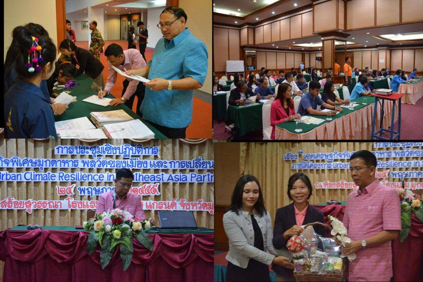
Key Issues of Vulnerability to Climate Change and Adaptive Actions
Shared Learning Dialogues (SLD) have been recommended by Thailand Environment Institute (TEI) to access in-
depth information on urban systems. This approach had been used in this study to assess climate-change patterns
experienced by local people in MSEZ. There were 43 representatives from 24 organizations participating in the SLD
which took place on s 24 May, 2016. The following is a list of these organizations in attendance:
1. Kwan Yai District Office
2. The Association of Tourism Industry, Mukdahan
3. Office of Tourism and Sports, Mukdahan
4. Office of Agriculture, Mukdahan
5. The Federation of Industries, Mukdahan
6. Office of Treasury, Mukdahan
7. Office of Labor, Mukdahan
8. Huay Khee Lover Group
9. Office of Natural Resources and Environment, Mukdahan
10 Office of Transportation, Mukdahan
11. Office of Energy, Mukdahan
12. Office of Meteorological Department, Mukdahan
13. Office of Commerce, Mukdahan
14. Chamber of Commerce, Mukdahan
15. Mukdahan Industrial Office, Mukdahan
16. Natural Resources and Environmental Protection Volunteer, Muang Mukdahan District, Mukdahan
17. District-Chief Officer (Muang Mukdahan )
18. Provincial Administration Organization
19. Office of Local Administration Promotion, Mukdahan
20. Phu Pha Tupe National Park, Mukdahan
21. Forestry Cooperative Center, Mukdahan
22. Provincial Water Work Authority, Mukdahan
23. Office of Public Works and Town Planning, Mukdahan
24. Mukdahan Media Presses
From the SLD, participants described and forecasted climate change patterns as summarized in Table 6. The public
opinion was well in agreement with the results obtained from long-term meteorological data analysis. Linear
regression analysis (shown in Figure 15) reveals significant (p < 0.05) declines in number of rainy days in the early
summer monsoon (March and May); whereas there is an increase in rainy days in winter season (January). Air
temperature during monsoon season also tends to be warmer. Minimum temperature is increasing in May, June and
November and maximum temperature is also increasing in June and July. Strong winds are subject to be found
anywhere between the months of January and September. Furthermore, from the study of International Centre for
Environmental Management (ICEM), shown in Figure 16, on changes in hydrological pattern associated with the
projected climate change in the Lower Mekong River, the result shows relatively increasing water level and flow
rate of the Mekong River at Mukdahan station due to the impact of climate change (ICEM, 2016). These findings20
could imply that climate and hydrological change in MSEZ are developing and its impacts potentially exacerbate in
the future.
Figure 14 Mukdahan SLD in 24th May, 2016
Table 6 Summary on Climate change patterns from the SLD
Past (30 year ago) Current Future (30 year ago)
Season shift and the Mekong
Season changed periodically More severe weather
River’s hydrological changes
with predictable pattern
are unpredictable
Hydrological pattern of the
Summer: unbearable heat,
Mekong River periodically
severe summer storms
changed with predictable pattern
Winter: short-term, found with
Summer: could live with air
rainy and warm days
conditioning
Rainy: unpredictable, severe
Rainy: flooding was
winter storms
experienced repeatedly due to
poor drainage system21 Figure 15 Significant linear regression of monthly meteorology from years 2000 to 2016 Source: Meteorological data acquired from Thailand Meteorological Department
22

Figure 16 Hydrological changes associated with climate change (CC) in average daily discharge (a) and water level
       (c) in the Lower Mekong River at Mukdahan station and their relative changes (b and d, respectively)
                                               Source: ICEM (2016)
Potential issues of vulnerability and their associated levels of significance and severity were discussed among SLD
participants. Key issues of vulnerability to climate change were assessed using a score-based analysis. The levels of
significance and severity each range from 0 (low) to 10 (high), judged by the agreement of all group members. Both
current severity and future severity were estimated. The scores were then estimated by multiplying the level of
significance with the level of severity. Key issues of vulnerability were chosen from those exhibiting high
significance and severity. Based on this assessment, a list of the key issues of vulnerability obtained from three SLD
groups is detailed in the following Table 7. In summary, three key issues of vulnerability were agreed upon the SLD
groups, which are 1) deforestation and forest land conversion, 2) outspreads of drug use and related crime, 3)
degraded water ecosystems and insufficient raw water during dry season.
23
Table 7 Matrix on significance and severity of potential issues of vulnerability in MSEZ
Future
Significance Significance
Current severity
Significance × Current × Future
Potential issues of vulnerability severity under
(10) severity severity
(10) climate
(100) (100)
changes(10)
SLD Group 1
1. Shallow natural waterways due to
10 10 10 100 100
estate development
2. Degraded water quality due to toxic
10 10 10 100 100
substance contamination
3. Deforestation 10 10 10 100 100
4. Outspread of drug use, especially in
10 10 10 100 100
labor sector
5. Burglary 10 8 10 80 100
6. Chemical contamination in
10 10 10 100 100
ecosystem
7. Insufficient traffic volume 8 8 10 64 80
8. Flooding due to poor drainage
8 8 8 64 64
system
9. Poor road conditions 5 5 7 25 35
10. Reduced agricultural areas due to
8 8 10 64 80
conversion to community area
11. Poor waste collection system 10 8 9 80 90
12. No space for landfill extension 10 5 9 50 90
13. Construction works block
8 8 10 64 80
waterways
14. Odor problem from industries 5 5 7 25 35
15. Noise pollution from night clubs 5 5 5 25 25
16. Relocation in search of higher
8 5 5 40 40
education
17. Poor traffic light system 7 7 8 35 56
SLD Group 2
1. Insufficient water for agriculture 10 5 8 50 80
2. Deforestation, Forest conversion 10 7 8 70 80
3. Crime relating to influxes of alien
8 4 8 32 64
laborers
SLD Group 3
1. Traffic jam 10 6 8 60 80
2. Solid waste overload 10 6 8 60 80
3. Crime/Increased drug use 10 7 8 70 80
4. Rising land price 10 5 10 50 100
5. High market competition 10 8 10 80 100
6. High living cost/ Debt 10 10 10 100 100
Participants were further consulted on current actions, obstacles and expected actions in responding to these key
issues of vulnerability. The details are described in Table 8.You can also read